GLENN LUKOS ASSOCIATES
|
|
|
- Bertram Crawford
- 5 years ago
- Views:
Transcription
1 GLENN LUKOS ASSOCIATES Regulatory Services May 15, 2014 Mr. Jason Keller Stratford Ranch Investors, LLC 4100 Newport Place Suite 400 Newport Beach, California SUBJECT: Results of a Pre-Construction Burrowing Owl Survey Conducted for the Stratford Ranch Alternative 2 Development Project, an Acre Property Located in the City of Perris, Riverside County, California. Dear Mr. Keller: This letter report documents the results of Glenn Lukos Associates (GLA) May 13, 2014 preconstruction burrowing owl (Athene cunicularia) survey for the Stratford Ranch Alternative 2 Development Project, an acre property located in the City of Perris, Riverside County, California. The burrowing owl pre-construction survey was conducted in accordance with the County of Riverside Burrowing Owl Survey Instructions for the Western Riverside Multiple Species Habitat Conservation Plan (MSHCP) Area, dated March 29, 2006, for the Project Site. The pre-construction burrowing owl survey satisfies the species-specific objective 6 of the MSHCP burrowing owl survey guidelines for the burrowing owl. This report complies with the County of Riverside Environmental Programs Department (EPD) and City of Perris MSHCP 30- day pre-construction burrowing owl survey report format. SITE LOCATION AND DESCRIPTION The Project comprises approximately acres of land, and is located within Assessor's Parcel Numbers , , , , , , , , , , , , , , , , , , , , , , , , , , , , , , , , , , and The Project site is located at Latitude and Longitude within Section 5, Township 4 South, and Range 3 West. The Project is
2 Mr. Jason Keller Stratford Ranch Investors, LLC May 15, 2014 Page 2 bounded by a residential development to the north, Ramona expressway (approximately 1250 feet to the south), Evans Road to the east, and the Perris Valley Storm Drain to the west, within the City of Perris, Riverside County, California [Exhibit 1]. The Project site contains one covered reservoir (as depicted on the U.S. Geological Survey [USGS] topographic map Perris, California [dated 1967 and photorevised in 1979] [Exhibit 2]. The Project site consists of vacant rural land that has been disturbed as a result of past human activities. The majority of the site has been disked, leaving behind trace evidence of trash and vegetation. In some areas disking was avoided, resulting in raised berms and denser vegetative growth. The Project site is dominated by non-native species and disturbed fields. Two moderately-sized man-made basins occur in the central and southern portions of the site, supporting cattails, willows, and other emergent vegetation. Common plant species that occurred in the disturbed fields include Russian thistle (Salsola tragus), African brass buttons (Cotula coronopifolia), and ripgut grass (Bromus diandrus). Plant species that occurred around the man-made basins included broad-leaved cat-tail (Typha latifolia), arroyo willow (Salix lasiolepis), mulefat (Baccharis salicifolia), duckweed (Lemna sp), and ragweed (Ambrosia psilostachya). METHODOLOGY On May 13, 2014, GLA biologist David Smith surveyed the Project Site for the burrowing owl. All avian, mammal, and representative plant species were documented. The survey was conducted between 07:00 and 10:00 hours. Weather conditions consisted of clear skies, with temperatures ranging between 52 o F to 89 o F, and wind speeds ranging from nine to twenty-six miles per hour. Burrowing Owl Survey The pre-construction burrowing owl presence/absence survey was conducted following the Burrowing Owl Survey Instructions for the Western Riverside County MSHCP. Upon arrival at the site, the surveying biologist scanned the site using binoculars to generally observe for burrowing owls on fence posts, debris piles, berms, etc. Following the initial site scan, the biologist walked the entire project site to survey for burrowing owls (see Burrowing Owl Transect Map, Exhibit 3). The survey was conducted by thoroughly traversing the site on foot to identify all diagnostic signs that are used to identify the presence/absence of the burrowing owl (e.g., burrowing owl, its molted feathers, cast pellets, prey remains, or excrement at or near a burrow entrance). Linear
3 Mr. Jason Keller Stratford Ranch Investors, LLC May 15, 2014 Page 3 transects were walked to allow for comprehensive coverage of the site. The pedestrian surveys followed adequately spaced transects to allow 100 percent visual coverage of the ground surface. The distance between the transect centerlines generally did not exceed 30 meters in width (approx 100 feet). 1 Transects were spaced appropriately to account for vegetation density and ground surface visibility. In addition, areas within 152 meters (500 feet) of the Project site boundary that had the potential to support the burrowing owl were scanned with binoculars. Exhibit 3 provides the approximate location of pedestrian transects. RESULTS No burrowing owls, or any evidence of burrowing owl occupation (i.e., diagnostic sign), were identified within the Project Site during the pre-construction survey. California ground squirrels (Otospermophilus beecheyi) were observed and several ground squirrel burrows were detected within the survey area throughout the site. However, none of the burrows exhibited any burrowing owl diagnostic sign. Birds identified on site during the pre-construction surveys included Common raven (Corvus corvax), American kestrel (Falco sparverius), killdeer (Charadrius vociferus), western meadowlark (Sturnella neglecta), European starling (Sturnus vulgaris), red-winged blackbird (Agelaius phoeniceus), cliff swallow (Petrochelidon pyrrhonota), barn swallow (Hirundo rustica), Say s phoebe (Sayornis saya), great blue heron (Ardea herodias), house finch (Carpodacus mexicanus), white-crowned sparrow (Zonotrichia leucophrys), mourning dove (Zenaida macroura), red-tailed hawk (Buteo jamaicensis), and American crow (Corvus brachyrhynchos). Mammals identified on site during the pre-construction survey included Audobon s cottontail (Sylvilagus audubonii) and California ground squirrel (Otospermophilus beecheyi). No reptile or amphibian species were detected on site during the burrowing owl pre-construction survey. Should you have questions, please contact Martin Rasnick at (949) , Ext The spacing of the pedestrian transects closely follows the Burrowing Owl Survey Instructions for the Western Riverside County MSHCP (March 29, 2006).
4 Mr. Jason Keller Stratford Ranch Investors, LLC May 15, 2014 Page 4 I hereby certify that the statements furnished above and in the attached exhibits present data and information required for this biological evaluation, and that the facts, statements, and information presented are true and correct to the best of my knowledge and belief. Signed: Date: May 15, 2014 s: a.burrowingowl.doc
5 Exhibit 1 Regional Map


, Esri")
6 Source: ESRI World Street Map ^ ± PROJECT LOCATION Miles STRATFORD RANCH ALTERNATIVE 2 DEVELOPMENT PROJECT Regional Map Sources: Esri, DeLorme, NAVTEQ, USGS, Intermap, ipc, NRCAN, Esri Japan, METI, Esri China (Hong Kong), Esri (Thailand), TomTom, 2013 Exhibit 1
7 Exhibit 2 Vicinity Map


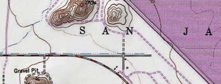


8 Adapted from USGS Perris, CA quadrangle ± PROJECT LOCATION 0 1,000 2,000 4,000 Feet STRATFORD RANCH ALTERNATIVE 2 DEVELOPMENT PROJECT Vicinity Map Copyright: 2013 National Geographic Society, i-cubed Exhibit 2
9 Exhibit 3 Burrowing Owl Transect Map


10 Source: Esri, DigitalGlobe, GeoEye, i-cubed, USDA, USGS, AEX, Getmapping, Aerogrid, IGN, IGP, swisstopo, and the GIS User Community Legend ± Project Boundary Burrowing Owl Transects (30 feet) Burrowing Owl Survey Buffer (500 feet) STRATFORD RANCH ALTERNATIVE 2 DEVELOPMENT PROJECT 700 Burrowing Owl Transect Map Feet Exhibit 3 X:\1100 AFTER THE REST\ OWL\1136-1_GIS\1136-1Transects.mxd
Nest Survey Report for Dana Point Harbor (Areas 1-16), City of Dana Point, Orange County, California
, City of Dana Point, Orange County, California") September 26, 2011 David Rocha OC Dana Point Harbor 24650 Dana Point Harbor Drive Dana Point, California 92629 Bakersfield 661.334.2755 Fresno 559.497.0310 Irvine 714.508.4100 Subject: Nest Survey Report
September 26, 2011 David Rocha OC Dana Point Harbor 24650 Dana Point Harbor Drive Dana Point, California 92629 Bakersfield 661.334.2755 Fresno 559.497.0310 Irvine 714.508.4100 Subject: Nest Survey Report
TEL FAX
 1500 IOWA AVENUE, SUITE 200 RIVERSIDE, CALIFORNIA 92507 951.781.9310 TEL 951.781.4277 FAX BERKELEY CARLSBAD FRESNO IRVINE PALM SPRINGS PT. RICHMOND ROCKLIN SAN LUIS OBISPO April 11, 2016 Mr. Rod Jones
Appendix C-2. Nesting Bird Survey
 Appendix C-2 April 27, 2014 Rincon Project Number: 14-00929 Glassell Park, LLC Attn: Nancy Johns 23622 Calabasas Road, Suite 220 Calabasas, California 91302 Via Email: wildflowerdevelopment@yahoo.com Subject:
Re: Coastal California Gnatcatcher Focused Survey Results for the Sunrise Gardens Property, City of San Marcos, San Diego County, California
 April 2 nd, 2006 Mr. John Westermeier Kleinfelder, Inc. 1370 Valley Vista Drive, Suite 150 Diamond Bar, CA 91765 Re: Coastal California Gnatcatcher Focused Survey Results for the Sunrise Gardens Property,
Northern Colorado Area Plan 230kV Transmission/Substation Project. Appendix D 2017 Biological Resources Report
 Northern Colorado Area Plan 230kV Transmission/Substation Project Appendix D 2017 Biological Resources Report December 14, 2017 Erin Degutis Xcel Energy Senior Agent, Siting and Land Rights 1800 Larimer
DANIEL EDELSTEIN, AVIAN BIOLOGIST
 Avian Biologist For 1 Kingfisher Court 415-3-17 (Office & FAX) The Environmental Consulting Field Novato, CA 94949 edelstein@earthlink.net, www.warblerwatch.com DANIEL EDELSTEIN, AVIAN BIOLOGIST April
Final Environmental Assessment
 Final Environmental Assessment For the National Foreign Affairs Training Center (NFATC) 2017 Master Plan Update Prepared by: The U.S. General Services Administration April 2017 65 NFATC 2017 Master Plan
Least Bell's Vireo & Western Burrowing Owl Surveys
 I - 15 CORRIDOR CAMPUS MASTER PLAN DRAFT EIR MT. SAN JACINTO COMMUNITY COLLEGE DISTRICT Appendices Appendix D5 Least Bell's Vireo & Western Burrowing Owl Surveys August 2017 I - 15 CORRIDOR CAMPUS MASTER
Attachment D: Nesting Bird Survey
 Attachment D: Nesting Bird Survey MONK & ASSOCIATES Environmental Consultants June 23, 2010 Lamphier-Gregory 1944 Embarcadero Oakland, California 94606 Attention: Ms. Rebecca Gorton RE: Preconstruction
The Quail Valley study area is located in the hills surrounding Railroad Canyon Reservoir, approximately 4 miles east of Lake Elsinore.
 County of Riverside - PSEC Project General Habitat Assessment Appendix A Quail Valley Quail Valley The Quail Valley study area is located in the hills surrounding Railroad Canyon Reservoir, approximately
Work Plan for Pre-Construction Avian and Bat Surveys
 Work Plan for Pre-Construction Avian and Bat Surveys, Steuben County, New York Prepared For: EverPower Wind Holdings, Inc. 1251 Waterfront Place, 3rd Floor Pittsburgh, PA 15222 Prepared By: Stantec Consulting
INFORMATION SUMMARY. D. APN#s: , , , and
 INFORMATION SUMMARY A. Report Date: April 28 th, 2015 B. Report Title: MSHCP Focused Burrowing Owl Surveys for the 37.08 Acre Decker Parcels I Project Site, Unincorporated Western Riverside County, California
SUBJECT: Scoped Environmental Impact Statement to Evaluate Species at Risk Potential on the Avalon West Property
 MEMORANDUM TO: Jocelyn Peloquin, Minto Communities Inc. FROM: Alex Zeller, Project Manager, Dillon Consulting Limited DATE: July 10, 2013 FILENO: 13-7777 SUBJECT: Scoped Environmental Impact Statement
DANIEL EDELSTEIN, AVIAN BIOLOGIST
 Avian Biologist For 12 Kingfisher Court 415-382-1827 (Office & FA) The Environmental Consulting Field Novato, CA 94949 edelstein@earthlink.net, www.warblerwatch.com DANIEL EDELSTEIN, AVIAN BIOLOGIST April
WORLAND COMMUNITY MARKERS
 APPENDIX A MAPS 1. Worland Community Markers 2. 2014 Jurisdictional Boundary 3. Current Land Use Map with Graph 4. Main Street Overlay 5. 2014 Street Functional Classification 6. Trail Master Plan Map
Eagle Observation Surveys Arkwright Summit Wind Project Chautauqua County, New York
 Eagle Observation Surveys Arkwright Summit Wind Project Chautauqua County, New York Final Report May August 2013 Prepared for: EDP Renewables 52 James Street 4 th Floor Albany, New York 12207 Prepared
Bob Powers Gateway Preserve. Alkali Mariposa Lily Survey
 Bob Powers Gateway Preserve Alkali Mariposa Lily Survey Prepared for: Kern River Valley Heritage Foundation P.O. Box 1249 Lake Isabella, California 93240 Field Work Conducted by: JayAnna Miller & Emily
An Employee-Owned Company
 1927 Fifth Avenue 2033 East Grant Road 5951 Encina Road, Suite 104 San Diego, CA 92101 Tucson, AZ 85719 Goleta, CA 93117 P 619.308.9333 P 520.325.9977 P 805.928.7907 F 619.308.9334 F 520.293.3051 www.reconenvironmental.com
Nesting bird and sensitive-species surveys of sites along the Los Angeles River and tributaries: Long Beach area
 MEMO Client: Attn: Cooper Ecological Monitoring, Inc. EIN 72-1598095 Daniel S. Cooper, President 255 Satinwood ave. oak park, ca 91377 (323) 397-3562 dan@cooperecological.com Friends of the Los Angeles
Appendix G. Burrowing Owl Survey Report
 Appendix G. BURROWING OWL SURVEY REPORT for the LIBERTY XXIII RENEWABLE ENERGY POWER PLANT PROJECT City of Banning Electric Utility Department 176 E. Lincoln Street Banning, CA 92220 Prepared by: Aspen
The Audubon Alaska WatchList 2017 Common species suspected to be declining
 The Audubon Alaska WatchList 2017 Common species suspected to be declining The WatchList identifies Alaska birds that are declining or vulnerable, therefore warranting special conservation attention. We
To: EverPower From: Stantec Consulting Services Inc. NYSDEC. 30 Park Drive Topsham, ME File: Date: February 11, 2014
 Memo To: From: Stantec Consulting Services Inc. NYSDEC 30 Park Drive Topsham, ME File: 195600883 Date: February 11, 2014 Reference: Cassadaga Wind Project Habitat Assessment INTRODUCTION Following the
FIELD DATA COLLECTION USING SMART PHONES, TABLETS, AND GPS DEVICES: A CASE STUDY. By Wende Mix & Mary Perrelli SUNY Buffalo State College
 FIELD DATA COLLECTION USING SMART PHONES, TABLETS, AND GPS DEVICES: A CASE STUDY By Wende Mix & Mary Perrelli SUNY Buffalo State College Outline Research Question Methodology Results Summary Research Question
Rick Sun, Los Angeles County Department of Public Works. Final Daily Biological Monitoring for the Oxford Retention Basin Multiuse Enhancement Project
 Memorandum To: From: Rick Sun, Los Angeles County Department of Public Works Matt Petty, CDM Smith Date: June 15, 2015 Subject: Final Daily Biological Monitoring for the Oxford Retention Basin Multiuse
Census 2010 Map Book. Conway Township
 Census Map Book Griswold Street, Suite, Detroit, Michigan Phone () -, Fax () - www.semcog.org Copyright: SEMCOG, Sources: Esri, DeLorme, NAVTEQ, TomTom, Intermap, AND, USGS, NRCAN, Kadaster NL, IGN, and
Santa Clara Valley Habitat Plan
 Santa Clara Valley Habitat Plan Joint Governing & Implementation Board Meeting Burrowing Owl Survey Summary and Fee Map January 15, 2015 29 1 Agenda Brief Overview of the Key Aspects of the Burrowing Owl
Rick Sun, Los Angeles County Department of Public Works. Final Daily Biological Monitoring for the Oxford Retention Basin Multiuse Enhancement Project
 Memorandum To: From: Rick Sun, Los Angeles County Department of Public Works Wendy Katagi, CDM Smith Harrison Kirner, SWCA Environmental Consultants Date: September 14, 2015 Subject: Final Daily Biological
Escondido Creek Conservation Parcels Bird Survey Report. prepared for San Elijo Lagoon Conservancy. by Maryanne Bache.
 Escondido Creek Conservation Parcels Bird Survey Report prepared for San Elijo Lagoon Conservancy by Maryanne Bache August 3, 2009 INTRODUCTION This report summarizes the results of a bird monitoring study
RAPTOR SURVEYS CONDUCTED AT NEAR WEST 2013 RESOLUTION COPPER MINING
 RAPTOR SURVEYS CONDUCTED AT NEAR WEST 2013 RESOLUTION COPPER MINING Prepared for: 102 Magma Heights PO Box 1944 Superior, Arizona 85173 Prepared by: 4001 E Paradise Falls Drive Tucson, Arizona 85712 April
C.4 Avian Study Summary of Results
 C.4 Avian Study Summary of Results Avian Baseline Studies for the Alta-Oak Creek Mojave Wind-Energy Project Kern County, California Summary of Results February 4 July 11, 2009 Prepared for: CH2M HILL Prepared
The Western Section of The Wildlife Society and Wildlife Research Institute Western Raptor Symposium February 8-9, 2011 Riverside, California
 The Western Section of The Wildlife Society and Wildlife Research Institute Western Raptor Symposium February 8-9, 2011 Riverside, California Symposium Sponsors February 9 08:55-09:15 am Session: Raptor
Wildlife observations at the Olentangy River Wetland Research Park in 1998
 Wildlife 155 Wildlife observations at the Olentangy River Wetland Research Park in 1998 Sarah K. Harter School of Natural Resources The Ohio State University Introduction The abundance and diversity of
Chokecherry and Sierra Madre Wind Energy Project
 Chokecherry and Sierra Madre Wind Energy Project Intensive Avian Protection Planning Avian Protection Summary In 2010, PCW initiated a collaborative process with BLM, USFWS, and Wyoming Game and Fish Department
RE: Biological Assessment Letter Report for the Fuel Tank Demolition Project located at 3300 Panorama Drive, Morro Bay, California (APN: )
") June 27, 2016 Chris Mathys Rhine LP and Morro 94 LLC 2141 Tuolomne Street Fresno, CA 93721 RE: Biological Assessment Letter Report for the Fuel Tank Demolition Project located at 3300 Panorama Drive, Morro
June 27, 2016 Chris Mathys Rhine LP and Morro 94 LLC 2141 Tuolomne Street Fresno, CA 93721 RE: Biological Assessment Letter Report for the Fuel Tank Demolition Project located at 3300 Panorama Drive, Morro
August 2, Dear Ms. Cruz:
 August 2, 2011 Jemellee Cruz, P.E. Flood Maintenance Division County of Los Angeles Department of Public Works 900 South Fremont Avenue Alhambra, CA 91803-1331 Subject: Pre-Construction Nesting Bird Survey
APPENDIX G. Biological Resources Reports
 APPENDIX G Biological Resources Reports November 9, 2009 David Geiser Merlone Geier Management, LLC 3580 Carmel Mountain Rd., Suite 260 San Diego, California 92130 RE: Neighborhood at Deer Creek, Petaluma,
LOCATION OF SHARP-TAILED GROUSE AND GREATER PRAIRIE-CHICKEN DISPLAY GROUNDS IN RELATION TO NPPD AINSWORTH WIND ENERGY FACILITY
 LOCATION OF SHARP-TAILED GROUSE AND GREATER PRAIRIE-CHICKEN DISPLAY GROUNDS IN RELATION TO NPPD AINSWORTH WIND ENERGY FACILITY 2006-2011 NEBRASKA GAME AND PARKS COMMISSION Bill Vodehnal, District Manager,
Field Guide. to Birds, Mammals & Wildflowers. Los Vaqueros. Reservoir & Watershed.
 Field Guide to Birds, Mammals & Wildflowers Reservoir & Watershed www.ccwater.com/losvaqueros Contents Guide to Birds 2 Guide to Mammals 6 Guide to Wildflowers 10 The Watershed The Watershed protects nearly
") ") ") ")")") ") ") ") ") ")80. Prepared by Sustainable Jersey for the Township of Middle, August Miles STATE HIGHWAY 49 STATE HIGHWAY 50
 ) ) ))) ) ) ) ) )80. Prepared by Sustainable Jersey for the Township of Middle, August Miles STATE HIGHWAY 49 STATE HIGHWAY 50") 54 21 80 STATE HIGHWAY 347 8 2 41 73 7 43 33 17 5 28 24 20 69 26 53 55 6 62 30 27 4 49 51 63 56 57 66 71 18 78 42 70 31 38 36 32 1 29 76 40 47 61 25 68 COUNTY ROAD 633 STATE HIGHWAY 49 COUNTY ROAD 557
54 21 80 STATE HIGHWAY 347 8 2 41 73 7 43 33 17 5 28 24 20 69 26 53 55 6 62 30 27 4 49 51 63 56 57 66 71 18 78 42 70 31 38 36 32 1 29 76 40 47 61 25 68 COUNTY ROAD 633 STATE HIGHWAY 49 COUNTY ROAD 557
2003 ANALYSIS OF AVIAN GUILD SPECIES DIVERSITY IN THE CARMEL RIVER RIPARIAN CORRIDOR. Twelfth Annual Report
 2003 ANALYSIS OF AVIAN GUILD SPECIES DIVERSITY IN THE CARMEL RIVER RIPARIAN CORRIDOR Twelfth Annual Report Prepared for the Monterey Peninsula Water Management District Monterey Peninsula Water Supply
PDX Wildlife Program. January 15 th, Nick Atwell Aviation Wildlife Manager
 PDX Wildlife Program January 15 th, 2014 Nick Atwell Aviation Wildlife Manager 1 Overview Program Background Eco-regional Context Four Pillars of the Wildlife Hazard Management Program Short-term Research
Supplemental Biological Resources Assessment for the RE Columbia Two Solar Project Site and Generation Tie-Line near Mojave, Kern County, California
 March 4, 2013 Attn: Ms. Charity Wagner Recurrent Energy 300 California Street, 8 th Floor San Francisco, CA 94104 Via email: charity.wagner@recurrentenergy.com Subject: for the RE Columbia Two Solar Project
STATEMENT OF QUALIFICATIONS
 STATEMENT OF QUALIFICATIONS Southern Nevada Environmental, Inc. (SNEI) is a certified Women and Minority-owned Small Business Enterprise, with offices in Las Vegas NV, and Victorville CA. SNEI is recognized
McLane Center and Silk Farm Sanctuary Comprehensive Environmental Education Guide
 New Hampshire Audubon McLane Center 84 Silk Farm Road Concord, NH 03301 McLane Center and Silk Farm Sanctuary Comprehensive Environmental Education Guide New Hampshire Audubon, a nonprofit statewide membership
45-day Summary Report of Focused Presence/Absence Surveys for the Coastal California Gnatcatcher
 I - 15 CORRIDOR CAMPUS MASTER PLAN DRAFT EIR MT. SAN JACINTO COMMUNITY COLLEGE DISTRICT Appendices Appendix D2 45-day Summary Report of Focused Presence/Absence Surveys for the Coastal California Gnatcatcher
Peregrine Falcon Falco peregrinus
 Plant Composition and Density Mosaic Distance to Water Prey Populations Cliff Properties Minimum Patch Size Recommended Patch Size Home Range Photo by Christy Klinger Habitat Use Profile Habitats Used
W W W. S M I T H D E L I V E R S. C O M
 December 31, 2012 Smith Environmental & Engineering Delivering Smart Solutions for Planning, Permitting, & Design Kathryn Bergh, P.E. CIP Project Manager City and County of Broomfield 1 DesCombes Drive
Skillbuilder 2: ID That Bird! Using Field Guides
 Bioblitz Skillbuilders: Learning and Applying the Skills of a Naturalist Skillbuilder 2: ID That Bird! Using Field Guides Key Question How can we use field guides to identify common birds? Objectives Students
FAWCETT ENVIRONMENTAL CONSULTING P.O. BOX 385 BODEGA, CA TELEPHONE: 707/ FAX: 707/
 FAWCETT ENVIRONMENTAL CONSULTING P.O. BOX 385 BODEGA, CA 94922 TELEPHONE: 707/876-3450 FAX: 707/876-3451 MHFAWCETT@AOL.COM SITE ASSESSMENT FOR CALIFORNIA TIGER SALAMANDER AT 3800 FINLEY AVENUE, SANTA ROSA,
FOCUSED BREEDING SEASON BURROWING OWL HABITAT ASSESSMENT AND SURVEY FOR THE ZANDERSON PLAZA PROJECT, CITY OF HEMET, CALIFORNIA
 FOCUSED BREEDING SEASON BURROWING OWL HABITAT ASSESSMENT AND SURVEY FOR THE ZANDERSON PLAZA PROJECT, CITY OF HEMET, CALIFORNIA ±8.67 Acre Property, ±8.67 Acres Surveyed APN 444-100-016, City of Hemet,
PRELIMINARY ECOLOGICAL ASSESSMENT REPORT Lake Hamilton Parcels: Polk County, Florida
 PRELIMINARY ECOLOGICAL ASSESSMENT REPORT Lake Hamilton Parcels: 272817829501000010 272817829503000040 272817829503000030 Polk County, Florida PREPARED BY: INWOOD CONSULTING ENGINEERS, INC. 3000 Dovera
Forde Biological Consultants, Burrowing Owl Survey, Vista Canyon Ranch, Los Angeles County, California
 Forde Biological Consultants, Burrowing Owl Survey, Vista Canyon Ranch, Los Angeles County, California Burrowing Owl Survey Vista Canyon Ranch, Los Angeles Counfy, California Prepared by: CAMARTLLo, CA
Snake River Float Project Summary of Observations 2013
 We thank Anya Tyson for stepping in to organize the Nature Mapping volunteers and to compile the data for 2013. She kept the project afloat for the year. Below is Anya s report. Snake River Float Project
Re: Environmental Review for Proposed Palmer Solar Project in El Paso County
 Southeast Region, Area 14 4255 Sinton Road Colorado Springs, CO 80907 P 719.227.5200 F 719.227.5223 May 21, 2018 juwi Inc. 1710 29 th Street, Suite 1068 Boulder, CO 80301 Re: Environmental Review for Proposed
NATURAL RESOURCES ASSESSMENT, INC.
 Panorama Properties Development Assessor s Parcel Map 437-360-009 San Jacinto, California Prepared for: Panorama Properties, Inc. 2005 Winston Court Upland, CA 91786 Prepared by: Natural Resources Assessment,
Appendix N. Haile Gold Mine EIS Supporting Information and Analysis for Visual Resources Assessment
 Appendix N Supporting Information and Analysis for Visual Resources Assessment This page is left blank intentionally. Table of Contents Page N. Methodology for Identification of Key Observation Points
State of Washington Department of Fish and Wildlife
 18 February 2015 Mr. Jon McAninch Cedarville Farms 15 White Oak Lane Oakville, WA 98568 Ph: (360) 273-9277 E-mail: cedarvillefarms@aol.com Dear Mr. McAninch: This letter is to provide you and Cedarville
Count Summary Report
 Count Name: Las Cruces Count Code: NMLC Count Date: 12/17/2011 Organizations & Mesilla Valley Sponsors: Audubon Society # of Party Hours: 112.65 Species reported on 117 count date: Compiler(s) First Name
Ronald Reagan Washington National Airport. Assessment of Measured Aircraft Noise Levels
 Ronald Reagan Washington National Airport Assessment of Measured Aircraft Noise Levels Presentation Outline Methodology Summary of Data Assessed High-Level Overview Focused Review of Selected Sites General
Bird Observations. Date Range: For. 1 of 5 2/29/2016 8:36 AM. Home About Submit Observations Explore Data My ebird Help
 1 of 5 2/29/2016 8:36 AM Home About Submit Observations Explore Data My ebird Help Hello Steve Lombardi (brycesteve) Preferences Sign Out Language «Hotspot Explorer Bird Observations For [ Mt. Diablo SP--Mitchell
Results of Nesting Bird Survey in Support of Fiscalini Ranch Forest Test Plots, Cambria, California
 May 26, 2016 Carlos Mendoza Cambria Community Services District 1316 Tamsen Drive, Suite 201 Cambria, California 93428 RE: Results of Nesting Bird Survey in Support of Fiscalini Ranch Forest Test Plots,
APPENDIX G. MCO East Airfield - Wildlife Data Review (Jan 9, 2015)
") APPENDIX G MCO East Airfield - Wildlife Data Review (Jan 9, 2015) MCO East Airfield - Wildlife Data Review Date: January 9, 2015 Subject: Project No: East Airfield Environmental Assessment Wildlife Analysis
APPENDIX G MCO East Airfield - Wildlife Data Review (Jan 9, 2015) MCO East Airfield - Wildlife Data Review Date: January 9, 2015 Subject: Project No: East Airfield Environmental Assessment Wildlife Analysis
KELLEY RESIDENCE PORCH ADDITION
 KELLEY RESIDENCE PORCH ADDITION 834 South Cassingham Road Steven Elbert Architect Ltd 2491 Sherwood Road (614) 338-1973 stevenelbert@gmail.com www.stevenelbert.com PRELIMINARY REVIEW SET FOR CITY OF BEXLEY
Ronald Reagan Washington National Airport. Assessment of Measured Aircraft Noise Levels [Appended] February 16, 2017
![Ronald Reagan Washington National Airport. Assessment of Measured Aircraft Noise Levels [Appended] February 16, 2017](/thumbs/95/122735742.jpg "Ronald Reagan Washington National Airport. Assessment of Measured Aircraft Noise Levels [Appended] February 16, 2017") Ronald Reagan Washington National Airport Assessment of Measured Aircraft Noise Levels [Appended] February 16, 2017 Presentation Outline Methodology Summary of Data Assessed High-Level Overview Focused
Ronald Reagan Washington National Airport Assessment of Measured Aircraft Noise Levels [Appended] February 16, 2017 Presentation Outline Methodology Summary of Data Assessed High-Level Overview Focused
Click on column heading to sort by that category.
 1 of 3 9/11/2018, 11:18 AM Navigation Tools Perform Another Search Show All Records Sort by Field Card Order Sort by Taxonomic Order View 1985 Data Block 6051A Summary Total Species: 66 Possible: 8 Probable:
12 March Terra Nova Planning and Research 400 S. Farrell Drive, Suite B-205 Palm Springs, CA (760) (FAX)
 (FAX)") 12 March 2010 Terra Nova Planning and Research 400 S. Farrell Drive, Suite B-205 Palm Springs, CA 92262 (760) 320-9040 (FAX) 322-2760 ATTN: John Criste RE: Altamira (TT 18255) Update to April 2007 Report
12 March 2010 Terra Nova Planning and Research 400 S. Farrell Drive, Suite B-205 Palm Springs, CA 92262 (760) 320-9040 (FAX) 322-2760 ATTN: John Criste RE: Altamira (TT 18255) Update to April 2007 Report
Sea & Sage Audubon Southern Sierra Spring Trip May 16-19, 2014 Bob Barnes, Trip Leader
 MAY 16: Butterbredt Spring (6:15 9:00 AM) 70-84 Eurasian Collared-Dove 1 Yellow Warbler 2 Mourning Dove 11 Townsend s Warbler 1 hummingbird sp. 1 Wilson s Warbler 3 Ladder-backed Woodpecker 1 Yellow-breasted
Birds Foraging on Jerusalem Crickets, with Recent Observations in the Central Valley, California
 Birds Foraging on Jerusalem Crickets, with Recent Observations in the Central Valley, California Gary Woods, Fresno Audubon Society, P. O. Box 9324, Fresno, CA 93791, woodshots@earthlink.net Hannah Nadel,
Appendix C Kern Water Bank Bird Survey Report: October mid April 2012
 Appendix C Kern Water Bank Bird Survey Report: ober mid April 212 Great Egret (Ardea alba) This page intentionally left blank. Woodland C A 95695 Phone: 53 98-3836 E-Mail: jst erling@w avecable.com Web:
VIRGINIA WORKING LANDSCAPES
 VIRGINIA WORKING LANDSCAPES Lazy Dog Farm 2017 Biodiversity Survey Results INTRODUCTION At Virginia Working Landscapes (VWL), our mission is to promote sustainable land use and conservation of native biodiversity
Survey Requirements. Design Guidelines and Standards. June Office of the University Architect
 Design Guidelines and Standards Survey Requirements June 2004 Office of the University Architect Construction Management P.O. Box 210181 Cincinnati, Ohio 45221-0181 Table of Contents Survey Requirements
APPENDIX 5F BIRD AND WILDLIFE POINT COUNTS AND AREA SEARCH SURVEYS BY HABITAT TYPE
 APPENDIX 5F BIRD AND WILDLIFE POINT COUNTS AND AREA SEARCH SURVEYS BY HABITAT TYPE Terrestrial Resources FTR Appendix 5F.doc Appendix Table 5F-1. Total numbers of birds detected during 2002 avian plot
R. Griswold Snowy Plover/Least Tern Monitoring Project 2009
 R. Griswold Snowy Plover/Least Tern Monitoring Project 2009 Identification California Least Tern Endangered 9-10 Nests in colonies Dives from air for fish Parents feed young Nesting colony can be fenced
Appendix B. Environmental Report
 A JOINT VENTURE BURLEY MUNICIPAL AIRPORT Project No. AIP No. 3 16 0006 08 Appendix B Environmental Report Site Selection Study Page B 1 EXCUTIVE SUMMARY This environmental site analysis report documents
Relicensing Study 3.5.1
 Relicensing Study 3.5.1 BASELINE INVENTORY OF WETLAND, RIPARIAN AND LITTORAL HABITAT IN THE TURNERS FALLS IMPOUNDMENT, AND ASSESSMENT OF OPERATIONAL IMPACTS ON SPECIAL-STATUS SPECIES Updated Study Report
Grassland Bird Survey Protocol Sauvie Island Wildlife Area
 Grassland Bird Survey Protocol Sauvie Island Wildlife Area Project Objective: Help determine if native grassland bird species are benefiting from restoration of grassland/pasture habitats at the Sauvie
APPENDIX F. Species Lists
 APPENDIX F Species Lists Breeding Bird Atlas Block 5557A 1 Mile Scale is approximately 1:25,000, but may vary on your printer. Breeding Bird Atlas Block 5557B 1 Mile Scale is approximately 1:25,000, but
Point Grey Tidal Marsh Project Standwatch Surveys February 20, 2014 to March 26, 2014
 Suite 250 1380 Burrard Street Vancouver, BC V6Z 2H3 T: 604.669.0424 F: 604.669.0430 hemmera.com Point Grey Tidal Marsh Project Standwatch Surveys February 20, 2014 to March 26, 2014 Report Date July 22,
City of Palmetto Florida
 Date Submitted: City of Palmetto Florida General Development/ Construction/ Final Site Plan Application For Planned Developments nly) PRJECT NAME: TYPE F APPRVAL DESIRED: See fee schedule below) Small
Preliminary Environmental Site Assessment Report
 Science Working For You Preliminary Environmental Site Assessment Report Wetland and Wildlife Survey Volusia County Parcel 06-19-32-00-00-0030 Prepared for: Orange Blossom Trail Orlando LLC 8650-12 Old
Section E NSPS MODEL STANDARDS FOR TOPOGRAPHIC SURVEYS Approved 3/12/02
 Section E NSPS MODEL STANDARDS FOR TOPOGRAPHIC SURVEYS Approved 3/12/02 1. INTRODUCTION This standard is written to provide the professional surveyor (Surveyor) and the client with a guideline for producing
NEST BOX TRAIL HISTORY
 NEST BOX TRAIL HISTORY 1985-2016 by KEITH EVANS and JACK RENSEL INTRODUCTION In August of 1984, members of the Wasatch Audubon Society (Ogden, Utah) held a workshop to construct bluebird nesting boxes.
Skillbuilder 2: ID That Bird! Using Field Guides
 Bioblitz Skillbuilders: Learning and Applying the Skills of a Naturalist Skillbuilder 2: ID That Bird! Using Field Guides Key Question How can we use field guides to identify common birds? Objectives Students
ZELLWOOD BIRD COUNTS JUNE, 2016
 ZELLWOOD BIRD COUNTS JUNE, 2016 June is often one of the quiet months but it does have the habit of turning up the unexpected so read on. There were four Roseate Spoonbills on the 21 st with an adult staying
SPECIAL PUBLIC NOTICE
 SPECIAL PUBLIC NOTICE Draft Map and Drawing Standards for the South Pacific Division Regulatory Program March 5, 2012 Comment period: ends April 5, 2012 Corps contact: Thomas Cavanaugh (415) 503-6574 (Thomas.J.Cavanaugh@usace.army.mil)
Application Submittal Checklist for a BASIC USE PERMIT (BUP) Planning & Development Department Planning Division
 Planning & Development Department Planning Division") Application Submittal Checklist for a BASIC USE PERMIT (BUP) APPLICABILITY. This checklist should be used when submitting an application for a Basic Use Permit. When is a Basic Use Permit required? Section
Application Submittal Checklist for a BASIC USE PERMIT (BUP) APPLICABILITY. This checklist should be used when submitting an application for a Basic Use Permit. When is a Basic Use Permit required? Section
Raptor Nest Field Survey Technical Memorandum for the North Meadows Extension to US 85 and Interstate 25
 for the North Meadows Extension to US 85 and Interstate 25 December 2007 Prepared for: Town of Castle Rock Douglas County Colorado Department of Transportation Federal Highway Administration Prepared by:
Checklist of birds on Nebraska farms
 1 Checklist of birds on Nebraska farms This checklist is based largely on observations of birds made, with permission, on Nebraska farms since the mid-1990s, as part of research conducted through the University
Masters College CAGN Report
 Masters College CAGN Report June 4, 2007 Mr. Greg Ainsworth Impact Sciences, Inc. 803 Camarillo Springs Road Suite A Camarillo, CA 93012 Subject: Results of Focused Coastal California Gnatcatcher Surveys;
Say s Phoebe Sayornis saya Conservation Profile
 Ed Harper Habitat Use Profile Habitats Used in California Grasslands, 1,2 open areas with bare ground, 3 agricultural areas 1 Key Habitat Parameters Plant Composition No plant affinities known. Plant Density
VIRGINIA WORKING LANDSCAPES
 VIRGINIA WORKING LANDSCAPES Marriott Ranch 2016 Biodiversity Survey Results INTRODUCTION At Virginia Working Landscapes (VWL) our mission is to promote sustainable land use and conservation of native biodiversity
Marsh Monitoring Program - Contact and Route Information
 Marsh Monitoring Program - Contact and Route Information Please complete and return original but keep a photocopy for your own reference. Year 2 0 Marsh (choose only one) Fresh water Brackish water Salt
CASSADAGA WIND PROJECT BIRD AND BAT SURVEY REPORT, Appendix A. Migration Survey Data Tables
 Appendix A Migration Survey Data Tables 51 Appendix A Table 1. number of species and individuals detected and distance from observer at 14 point count locations during 4 survey periods, Cassadaga Wind
California Least Tern & Western Snowy Plover Monitoring Project. Huntington State Beach Least Tern Natural Preserve A Partnership Since 2005
 California Least Tern & Western Snowy Plover Monitoring Project Huntington State Beach Least Tern Natural Preserve A Partnership Since 2005 Identification California Least Tern - CLTE Endangered 9-10 Nests
MAKE YOUR GARDEN A HOME FOR BIRDS, BUTTERFLIES, & OTHER CRITTERS. Quita Sheehan, Conservation Specialist, Vilas County Land & Water Conservation
 MAKE YOUR GARDEN A HOME FOR BIRDS, BUTTERFLIES, & OTHER CRITTERS Quita Sheehan, Conservation Specialist, Vilas County Land & Water Conservation TALK OUTLINE Structural & plant components of wildlife habitat
SAND CREEK MASSACRE NATIONAL HISTORIC SITE BIRD INVENTORY FINAL REPORT
 SAND CREEK MASSACRE NATIONAL HISTORIC SITE BIRD INVENTORY FINAL REPORT Tony Leukering Submitted by: David Hanni Monitoring Division, Director Rocky Mountain Bird Observatory Submitted to: Dusty Perkins
Site Plan/Building Permit Review
 Part 6 Site Plan/Building Permit Review 1.6.01 When Site Plan Review Applies 1.6.02 Optional Pre- Application Site Plan/Building Permit Review (hereafter referred to as Site Plan Review) shall be required
Appendix D-8. Avian Baseline Studies 2011
 Appendix D-8 Avian Baseline Studies 2011 Avian Baseline Studies at the Alta East Wind Resource Area Kern County, California Final Report July 10, 2010 June 1, 2011 Prepared for: CH2M HILL 155 Grand Avenue
FINAL BIOLOGICAL HAZARD ABATEMENT PLAN FOR NON-TIME-CRITICAL REMOVAL ACTION FOR POLYCHLORINATED BIPHENYL (PCB) CONTAMINATION
 CONTAMINATION") FINAL BIOLOGICAL HAZARD ABATEMENT PLAN FOR NON-TIME-CRITICAL REMOVAL ACTION FOR POLYCHLORINATED BIPHENYL (PCB) CONTAMINATION AT Installation Restoration (IR) Site 29, Hangar 1 Former Naval Air Station
FINAL BIOLOGICAL HAZARD ABATEMENT PLAN FOR NON-TIME-CRITICAL REMOVAL ACTION FOR POLYCHLORINATED BIPHENYL (PCB) CONTAMINATION AT Installation Restoration (IR) Site 29, Hangar 1 Former Naval Air Station
Wings N Wetlands Bird List
 Wings N Wetlands Bird List - 2015 The following list represents the species of birds seen on April 24 April 25, 2015 at Cheyenne Bottoms and Quivira National Wildlife Refuge during the Wings N Wetlands