HIGH-ACCURACY GYROCOMPASS
|
|
|
- Robyn James
- 5 years ago
- Views:
Transcription


1 HIGH-ACCURACY GYROCOMPASS and INERTIAL NAVIGATION PRODUCTS NAVAL NAVIGATION LAND NAVIGATION & POINTING AIR NAVIGATION COMMERCIAL & INDUSTRIAL
2 GEM elettronica is a leading European supplier in the design, development and manufacturing of Navigation Systems in service with customers worldwide. GEM elettronica has developed an extensive portfolio of Advanced Fiber Optic Guidance and Navigation Products featuring state-of-the-art technologies and innovative designs. Inertial Measurement Unit (IMU) is the heart of GEM elettronica Inertial Systems composed of motion and speed sensors. IMU is able to accurately measure rotation rates and accelerations of the platform on which is installed. Attitude and Heading Reference System (AHRS) consists of sensors on three axes that provide Heading and Attitude information for vehicle, including Roll, Pitch and Yaw. Inertial Navigation System (INS) Coupling its state of the art Inertial Measurement Units with advanced Kalman filtering, GEM elettronica developed a wide family of high performance Inertial Navigation Systems. INS provides position, orientation, direction and speed of a moving vehicle with no need of external references. GEM Quality Management System Certifications Company Quality Assurance System Appraisal Methodology for Process Improvement Scientific and Technological Research ISO9001:2008 GEM Award Italian Physical Society GEM Product Certifications GL
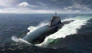
3 NAVAL NAVIGATION GEM elettronica is specialized in the design, development and manufacturing of a wide range of high-performance solutions based on Fiber-Optic technology. Gyrocompasses and Inertial Navigation Systems are fundamental in today Naval Defense for supporting worldwide marine and submarine missions. LAND NAVIGATION & POINTING GEM elettronica develops Inertial Navigation Systems specifically for Stabilization, Aiming and Land Navigation. Localix INS are selected by trusted Defense Industries as their main navigation solution in advanced armored vehicle programs. AIR NAVIGATION GEM elettronica provides high-performance inertial Navigation Systems in avionics dynamic situations. Our Inertial Solutions offer Orientation, Attitude and Georeferencing information also in GNSS-denied environments. COMMERCIAL & INDUSTRIAL GEM elettronica is committed to provide innovative Inertial solutions for the most demanding needs of Commercial Industry. Our products are used in a wide range of critical applications generating significant benefits for the ownship.

4

5 ADVANCED ATTITUDE/HEADING AND INERTIAL NAVIGATION SYSTEMS FOR WORLDWIDE NAVIES NAVAL NAVIGATION Polaris FOG family GEM elettronica POLARIS FOGs are high-accuracy and high-reliability Gyrocompasses and Inertial Navigation Systems for maritime and naval applications, where accurate navigation and performances are required. POLARIS FOG family is IMO Type Approved and provides accurate heading, attitude, velocity, depth, heave and position information for a complete navigation solution with no need of external references. SURF FOG family Designed for worldwide navies, SURF-100 and SURF-200 are the ultimate solution for compact and precise inertial navigation featuring high accuracy and low settling time. SURF family is the top of the line Inertial Navigation System specifically designed to provide a superior Inertial Navigation solution on both Surface Warship and Submarines. FGU Stabilization System The FGU-200 is a rugged, reliable and very compact dual axis gyro system realized with state-of-the-art closed loop Fiber Optic Gyroscopes (FOG) that provides exceptional stabilization and tracking capabilities. GEM elettronica FGU-200 gyros provide superior performance with a very low noise, low latency with hight resolution, wide measuring range and bandwidth.

 Heading Alignment Type Approval 0.4 0.1 > 100,000 h N.A. < 10 min IMO/IMO HSC")
6 NAVAL NAVIGATION Polaris FOG-50 GYROCOMPASS & MOTION SENSOR Mature Fiber-Optic Technology Maintenance Free Fast Settling Time Surface Gyrocompassing Ideal For Fast Patrol Boat Coastal Defense ships Heading Accuracy no GPS aiding (Sec Lat RMS) Roll/Pitch Accuracy (RMS) MTBF Position Accuracy no aiding, no GPS (TRMS) Heading Alignment Type Approval > 100,000 h N.A. < 10 min IMO/IMO HSC

 Heave (real time) MTBF Position Accuracy (TRMS) Heading Alignment ITAR Components")
 1.")
7 Polaris FOG-100/INS SURFACE AHRS / INS High Reliability Strapdown FOG technology Unattainable Service Life Surface Navigation and Positioning Ideal For Large Patrol Vessels Amphibious Assault ships Heading Accuracy (Sec Lat RMS) Roll/Pitch Accuracy (RMS) Heave (real time) MTBF Position Accuracy (TRMS) Heading Alignment ITAR Components Type Approval % or 5 m whichever is greater > 100,000 h 3 m CEP (GPS signal available) 1.8 NM / 12h CEP (with LOG aiding) 3.5 NM / 12h CEP (full inertial) < 10 min NO IMO/IMO HSC

 1 NM / 12 h CEP (with LOG aiding) 2 NM / 12 h CEP (full inertial) < 10 min NO")
8 NAVAL NAVIGATION Polaris FOG-200/INS SURFACE AHRS / INS High Performances without external aiding Advanced Positioning Algorithm High Dinamic accuracy Surface Gyrocompassing and Positioning Mini-sub Navigation and Positioning systems Target acquisition systems Ideal For Corvettes Frigates Heading Accuracy no GPS aiding (Sec Lat RMS) Roll/Pitch Accuracy (RMS) Heave (real time) MTBF Position Accuracy (TRMS) Heading Alignment ITAR Components Type Approval % or 5 m whichever is greater > 100,000 h 3 m CEP (GPS signal available) 1 NM / 12 h CEP (with LOG aiding) 2 NM / 12 h CEP (full inertial) < 10 min NO IMO/IMO HSC

 Heading Alignment ITAR Components Type Approval 0.05 0.")
9 SURF-100 HIGH ACCURACY SYSTEM FOR WARSHIPS NAVIGATION Very High INS Performances Strapdown FOG Technology MIL/IMO approved standard Warships Military Submarines Ideal For Aircraft Carriers Destroyers Cruisers Heading Accuracy no GPS aiding (Sec Lat RMS) Roll/Pitch Accuracy (RMS) MTBF Position Accuracy no aiding, no GPS (TRMS) Heading Alignment ITAR Components Type Approval > 100,000 h 1 NM / 12 h < 5 min NO IMO/IMO HSC

 Heading Alignment ITAR Components 0.01 0.")
10 NAVAL NAVIGATION SURF-200 HIGH ACCURACY SYSTEM FOR UNDERWATER NAVIGATION Strategic Grade Fiber Optic sensors Extremely high resolution Ultimate Dead reckoning performances MilSpecs qualified Military Submarines Warships Ideal For Attack Submarines Ballistic missile submarines Cruise missile submarines Heading Accuracy no GPS aiding (Sec LatRMS) Roll/Pitch Accuracy (RMS) MTBF Position Accuracy no aiding, no GPS (TRMS) Heading Alignment ITAR Components >100,000 h 1 NM / 72 h < 5 min NO

 Input voltage Operating Temperature Weight < 5 sec 0.12 / h 3.5 /h (1σ) 1.")
11 FGU-200 FOG DUAL AXIS STABILIZATION SYSTEM No moving parts Compact and light Low Latency, Low Noise Very Low Start-up Time Extremely High Bandwidth Gun turret stabilization EO/FLIR stabilization Radar antenna stabilization Precision Pointing Line-of-sight tracking Start-up time Angle Random Walk Bias repeatability (day to day) Bias instability (In run) Scale Factor Error (Over temperature) Dynamic Range (Angular Rate) Input voltage Operating Temperature Weight < 5 sec 0.12 / h 3.5 /h (1σ) 1.8 /h (1σ) 100 ppm/ C ± 500 /s VDC - 40 C / + 70 C 1.89 kg

12

13 INERTIAL LAND NAVIGATION, POSITIONING & POINTING SYSTEMS LAND NAVIGATION & POINTING Localix Land Defence Inertial Navigation & Pointing Systems LOCALIX INS is GEM elettronica Land Navigation family specifically designed for the tactical land navigation market. Thanks to innovative fusion between ITAR-Free sensors and proprietary inertial algorithms, LOCALIX family represents the ideal support providing high-accuracy inertial data to Armored Vehicles. LOCALIX INS provides real time highest-performances even when GPS data are not available due to mission natural scenario or interferences. Through its high accuracy and fast alignment, LOCALIX is often applied even in artillery pointing. FGU Stabilization System The FGU-200 is a rugged, reliable and very compact dual axis gyro system realized with state-of-the-art closed loop Fiber Optic Gyroscopes that provide exceptional stabilization and tracking capabilities. FGU-200 is a solid state sensor containing no moving parts, it has mechanical enhancements to work in extreme environmental conditions, resisting the effects of dust, water and electromagnetic interference and can also withstand the shock and vibration of military vehicles. FGU-200 does not require any maintenance or calibration, its MTBF is more than 50,000 hours.

 Start-up Time Valid Data (s) GPS not Available < 3% DT GPS Available Depend on GPS receiver performances optional < 3 min 30 sec <")
14 LAND NAVIGATION & POINTING Localix M-3 MEMS BASED INERTIAL NAVIGATION SYSTEM (INS) Compact Low weight Easy to Integrate with any external sensor Fast real-time navigation data High stability MEMS architecture Advanced Navigation Kalman filter Land Navigation and orientation Unmanned Surface vehicles Mobile Mapping Ideal For Light Multi-role Wheeled Vehicles Navigation Accuracy no aiding, no GPS (RMS) Embedded GPS receiver Setup Time Fast Setup Time (Stored Data) Start-up Time Valid Data (s) GPS not Available < 3% DT GPS Available Depend on GPS receiver performances optional < 3 min 30 sec < 5 s
")
 Start-up Time Valid Data ITAR Components 8 mils < 2 mils 0,3% DT > 80,000 h Optional < 10 min 30 s < 5 s")
15 Localix 120 TACTICAL GRADE FOG INS Strapdown FOG Technology Proven Robustness Easy to install and operate Robust to GNSS outages Low consumption Land Navigation and Positioning Ideal For Wheeled & Tracked Vehicles GPS denied operations Heading Accuracy (RMS) Roll/Pitch Accuracy (RMS) Position Accuracy (VMS only) Horizontal Position (CEP) MTBF Embedded GPS Fully Accuracy Setup Time Fast Setup Time (Stored Data) Start-up Time Valid Data ITAR Components 8 mils < 2 mils 0,3% DT > 80,000 h Optional < 10 min 30 s < 5 s NO

 Horizontal Position (CEP) MTBF Embedded GPS Setup Time Fast Setup Time (Stored Data) Start-up Time Valid Data ITAR")
16 LAND NAVIGATION & POINTING Localix 100 Localix 200 HIGH-GRADE FOG INS Solid State FOG technology Autonomous Navigation in GPS denied environment Extreme shock endurance Superior reliability Easy system integration Land Navigation and Positioning Artillery Pointing Ideal For Wheeled & Tracked Vehicles GNSS denied operations Heading Accuracy (RMS) Roll/Pitch Accuracy (RMS) 5 mils < 2 mils 1 mils < 0.35 mils Position Accuracy (VMS only) Horizontal Position (CEP) MTBF Embedded GPS Setup Time Fast Setup Time (Stored Data) Start-up Time Valid Data ITAR Components 0.2% DT 0.1% DT > 80,000 h Optional < 10 min 30 s < 5 s NO

 Input voltage Operating Temperature Weight < 5 sec 0.12 / h 3.5 /h (1σ) 1.")
17 Localix FGU-200 FOG DUAL AXIS ARTILLERY STABILIZATION Consistent performance under extreme conditions Compact and rugged package Low power consumption Superior dynamic range Wide range thermal performance Gun turret stabilization EO/FLIR stabilization Radar antenna stabilization Precision Pointing Line-of-sight tracking Start-up time Angle Random Walk Bias repeatability (day to day) Bias instability (In run) Scale Factor Error (Over temperature) Dynamic Range (Angular Rate) Input voltage Operating Temperature Weight < 5 sec 0.12 / h 3.5 /h (1σ) 1.8 /h (1σ) 100 ppm/ C ± 500 /s VDC - 40 C / + 70 C 1.89 kg

18

19 AIRBONE NAVIGATION & GUIDANCE SYSTEMS AIR NAVIGATION MBI-100: Guidance & Stabilization System MBI-100 is the full inertial solution proposed by GEM elettronica in order to meet the stringent demands for Guidance and Stabilization Systems, even in GNSS-denied environments. MBI-100 takes advantage of GEM elettronica s innovative sensor fusion algorithm and provides continuous precision positioning and attitude data in all conditions. With its outstanding reliability and stable performances, MBI-100 is designed for both civil and military applications and represents a fundamental support for real-time navigation, guidance and flight control of Unmanned Aircraft Systems. AIRFOG Navigation Family GEM elettronica FOG Solution for Airborne Navigation represents the most advanced Flight Control System. Thanks to in-house Fiber-Optic Technology, AIRFOG family provides an instant and continuous Navigation Solution in all avionics dynamic environments. Inertial Measurement Unit Inertial Measurement Units: GEM elettronica designs and manufactures a wide range of Customizable Inertial Measurement Units able to meet the specific client's requirements. Fields of application for the IMU can range from camera or antenna stabilization up to terrestrial, air, sea or subsea inertial navigation, with accuracy ranging from tactical grade to strategic grade.

 < 75 m for 5 minutes after GPS outage < 0.4 m/s for 5 minutes after GPS outage < 0.5 Pitch & Roll dynamic accuracy (1σ) < 0.4 < 1.5 < 3.")
20 AIR NAVIGATION MBI-100 GNSS AIDED MEMS INERTIAL NAVIGATION SOLUTION High stability MEMS architecture 72 channel advanced GNSS receiver Static and dynamic air pressure sensors Innovative sensor fusion technology All-in-one self contained navigation solution Lightweight and compact rugged enclosure Tightly coupled navigation solution Easy to integrate with all software suites UAV Guidance and Navigation Control Parameters Position (CEP) Velocity (1σ) Pitch & Roll static accuracy (1σ) GPS/INS < 2.5 m < 0.1 m/s < 0.2 Only Baro (no GPS) < 0.3 Fully inertial (no Baro & GPS) < 75 m for 5 minutes after GPS outage < 0.4 m/s for 5 minutes after GPS outage < 0.5 Pitch & Roll dynamic accuracy (1σ) < 0.4 < 1.5 < 3.0 Heading dynamic accuracy (1σ) Altitude < 1 < 10 m < 1.5 for 5 min outage < 20 m

 Position Accuracy no aiding, no GPS (TRMS)")

21 AIRFOG AIRBORNE NAVIGATION SYSTEM High update range Real time stable flight parameters Sensor fusion algorithms Highly Configurable Drones guidance Airborne survey Corridor mapping LIDAR Heading Accuracy (Sec Lat RMS) Roll/Pitch Accuracy (RMS) Position Accuracy no aiding, no GPS (TRMS) Position Accuracy GPS aided (CEP50): - P(Y) Position Code - Coarse/Acquisition code - DGPS Ground Alignment Time Embedded GPS nmi/h 5 m 10 m 2 m 4 min Option
")

22 AIR NAVIGATION AIRFOG-ADV HIGH-ACCURACY AIRBORNE NAVIGATION SYSTEM Space-grade FOG sensors High update range Advanced INS solution Highly Configurable Aircraft Navigation Airborne Survey Heading Accuracy (Sec Lat RMS) Roll/Pitch Accuracy (RMS) Position Accuracy no aiding, no GPS (TRMS) Position Accuracy GPS aided (CEP50): - P(Y) Position Code - Coarse/Acquisition code - DGPS Ground Alignment Time Embedded GPS nmi/h 5 m 10 m 2 m 4 min Optional


23 INERTIAL MEASUREMENT UNIT IMU FIBER OPTIC BASED TECHNOLOGY State of the Art Fiber Optic Gyroscopes Sensors accuracy ranging from tactical grade to strategic grade High customizable housing, performances and interfaces High Performances over extreme shock, temperature and vibration IMU-3000 IMU-1000 IMU-500 IMU-250 Gyro Dynamic Range ± 40 /s ± 240 /s ± 480 /s ± 960 /s Gyro ARW 7 x 10⁻⁴ / h 2 x 10⁻³ / h 3 x 10⁻³ / h 7 x 10⁻³ / h Accel. Range ± 30 G ± 30 G ± 5 G ± 5 G Accel. Bias Instability < 40 µg < 1000 µg < 3750 µg < 3750 µg Output Rate 2000 Hz 2000 Hz 2000 Hz 2000 Hz

24

25 NAVIGATION AND CONTROL SOLUTIONS FOR CIVIL MARINE AND INDUSTRIAL APPLICATIONS COMMERCIAL & INDUSTRIAL Navigation Polaris Family POLARIS Family Systems include a wide range of Surface and Underwater Navigation Solutions for civil marine industry. Civil Engineering, Drilling & Mining GEM elettronica developed specific Tools for Surface and Underground Projects in the field of Mining and Civil Engineering. Orient and Orient Plus meet the most demanding industrial engineers requirements removing human setup errors. Wireless Connectivity makes these products easily controllable and maneuverable by a single technician, improving productivity and safety. Thanks to the absence of moving parts and high reliability technology, the system does not require any maintenance or recalibration and ensures long life in extreme environments. Command and control device options GEM elettronica Navigation & Control Systems are supplied with an intuitive and fully configurable Graphic User Interface. The End-User can choose the best solution between the Touch Screen Control Display Unit and the Application GUI software. Option A: Control Display Unit Option B: GUI Software Suite

 Velocity accuracy (1σ) Pitch & Roll static accuracy (1σ) Pitch & Roll dynamic")

26 COMMERCIAL & INDUSTRIAL Polaris M-10 GNSS-AIDED MEMS INERTIAL NAVIGATION SYSTEM Calibrated MEMS sensors GNSS/INS Integrated solution Multi-GNSS receiver embedded Positioning data with limited GNSS visibility Compact and versatile Search And Rescue (SAR) Small Workboats Heading dynamic accuracy (1σ) GNSS-aiding Position accuracy (CEP) Velocity accuracy (1σ) Pitch & Roll static accuracy (1σ) Pitch & Roll dynamic accuracy (1σ) Time to first position fix Time to first heading fix < 1 < 2.5 m < 2 m (SBAS) < 0.1 m/s < 0.2 < s (Cold start) 1 s (Hot start) 30 s (Coarse magnetic aligment), 300 s (Fine alignment) after GPS fix

 Heading Alignment Type Approval 0.4 0.1 > 100,000 h N.A. < 10 min IMO/IMO HSC")
27 Polaris FOG-50 IMO-STANDARD MARINE GYROCOMPASS SYSTEM Reliable Fiber Optic Tecnology Type Approved No Preventive Maintenance Quick and flexible Installation Maritime Gyrocompassing Ideal for Cargoes Oil Tankers Super Yachts Ferry Boats Heading Accuracy (Sec Lat RMS) Roll/Pitch Accuracy (RMS) MTBF Position Accuracy no aiding, no GPS (TRMS) Heading Alignment Type Approval > 100,000 h N.A. < 10 min IMO/IMO HSC


")
 Heading Alignment Type Approval 0.")
28 COMMERCIAL & INDUSTRIAL Polaris FOG-100 SURFACE GYROCOMPASS & MOTION SENSOR Solid State Technology Calibrated for life Fast Settling Time Plug and Play Configuration Maritime Gyrocompassing Stabilization System Dynamic Positioning Ideal for Commercial and Shipping Vessels Heading Accuracy (Sec Lat RMS) Roll/Pitch Accuracy (RMS) MTBF Position Accuracy no aiding, no GPS (TRMS) Heading Alignment Type Approval > 100,000 h N.A. < 10 min IMO/IMO HSC

 Roll/Pitch Accuracy (RMS) Heave (real time) MTBF")
 1 NM / 12 h CEP (with LOG")
29 ORACLE TEAM USA official supplier Polaris FOG-200/INS SURFACE AND UNDERWATER GYROCOMPASS & INERTIAL NAVIGATION Calibration Free Strapdown Technology Maritime Gyrocompassing Inertial Navigation Dynamic Positioning Ideal for Manned and unmanned surface and underwater vehicles Oceanographic and hydrographic operations Heading Accuracy (Sec Lat RMS) Roll/Pitch Accuracy (RMS) Heave (real time) MTBF Position Accuracy (TRMS) Heading Alignment Type Approval % or 5 m whichever is greater > 100,000 h 3 m CEP (GPS signal available) 1 NM / 12 h CEP (with LOG aiding) 2 NM / 12 h CEP (full inertial) < 10 min IMO/IMO HSC


 MTBF Position Accuracy no aiding, no GPS (TRMS)")
30 COMMERCIAL & INDUSTRIAL ORIENT STABILIZATION AND GEOREFERENCING SYSTEM FOR CONSTRUCTION INDUSTRY Fast SettlingTime High Reliability Quick installation Unaffected by magnetic field Wireless Connectivity Underground & Surface Drilling Ground Engineering applications Platform Monitoring & Stabilization Azimuth Accuracy (Sec Lat RMS) Roll/Pitch Accuracy (RMS) MTBF Position Accuracy no aiding, no GPS (TRMS) > 100,000 h Optional

 Roll/Pitch Accuracy (RMS) MTBF Position Accuracy no aiding, no GPS (TRMS) 0.1 0.")
31 ORIENT PLUS TRUE NORTH ALIGNER AND GEOREFERENCING SYSTEM NO Maintenance Real time measurement Military grade technology High Reliability High-speed Wireless connectivity Underground & Surface Drilling Ground Engineering applications Mobile mapping Unmanned vehicles guidance and stabilization Azimuth Accuracy (Sec Lat RMS) Roll/Pitch Accuracy (RMS) MTBF Position Accuracy no aiding, no GPS (TRMS) > 100,000 h Optional
32 FIND YOUR INERTIAL PRODUCT Gyrocompassing Surface Navigation Underwater Navigation ROV / AUV Guidance GNSS-Aided Navigation Hydrographic Survey Stabilization Land Navigation Alignment / Pointing Airborne / UAV Guidance Polaris M-10 Polaris FOG-50 Polaris FOG-100 Polaris FOG-200 SURF-100 SURF-200 FGU-200 MBI-100 AIRFOG AIRFOG-ADV Localix M-3 Localix 120 Localix 100 Localix 200 Orient Orient Plus inertial@gemrad.com This brochure should not be considered a contractual offer to sell. The specifications given herein may be changed by the manufacturer, GEM elettronica S.r.l., without notice. May 17, 2018
Inertial Systems. Ekinox Series TACTICAL GRADE MEMS. Motion Sensing & Navigation IMU AHRS MRU INS VG
 Ekinox Series TACTICAL GRADE MEMS Inertial Systems IMU AHRS MRU INS VG ITAR Free 0.05 RMS Motion Sensing & Navigation AEROSPACE GROUND MARINE EKINOX SERIES R&D specialists usually compromise between high
Inertial Navigation System
 Apogee Marine Series ULTIMATE ACCURACY MEMS Inertial Navigation System INS MRU AHRS ITAR Free 0.005 RMS Navigation, Motion & Heave Sensing APOGEE SERIES makes high accuracy affordable for all surveying
CODEVINTEC. Miniature and accurate IMU, AHRS, INS/GNSS Attitude and Heading Reference Systems
 45 27 39.384 N 9 07 30.145 E Miniature and accurate IMU, AHRS, INS/GNSS Attitude and Heading Reference Systems Aerospace Land/Automotive Marine Subsea Miniature inertial sensors 0.1 Ellipse Series New
MARINS Series. Very high performance inertial navigation system
 MARINS Series Very high performance inertial navigation system MARINS M-Series Very high-performance inertial navigation system MARINS M-Series is a family of state-of-the-art naval inertial navigation
Inertial Sensors. Ellipse Series MINIATURE HIGH PERFORMANCE. Navigation, Motion & Heave Sensing IMU AHRS MRU INS VG
 Ellipse Series MINIATURE HIGH PERFORMANCE Inertial Sensors IMU AHRS MRU INS VG ITAR Free 0.1 RMS Navigation, Motion & Heave Sensing ELLIPSE SERIES sets up new standard for miniature and cost-effective
Inertial Sensors. Ellipse 2 Series MINIATURE HIGH PERFORMANCE. Navigation, Motion & Heave Sensing IMU AHRS MRU INS VG
 Ellipse 2 Series MINIATURE HIGH PERFORMANCE Inertial Sensors IMU AHRS MRU INS VG ITAR Free 0.1 RMS Navigation, Motion & Heave Sensing ELLIPSE SERIES sets up new standard for miniature and cost-effective
Inertial Systems. Ekinox 2 Series TACTICAL GRADE MEMS. Motion Sensing & Navigation IMU AHRS MRU INS VG
 Ekinox 2 Series TACTICAL GRADE MEMS Inertial Systems IMU AHRS MRU INS VG ITAR Free 0.02 RMS Motion Sensing & Navigation AEROSPACE GROUND MARINE EKINOX 2 SERIES R&D specialists usually compromise between
Inertial Sensors. Ellipse 2 Series MINIATURE HIGH PERFORMANCE. Navigation, Motion & Heave Sensing IMU AHRS MRU INS VG
 Ellipse 2 Series MINIATURE HIGH PERFORMANCE Inertial Sensors IMU AHRS MRU INS VG ITAR Free 0.1 RMS Navigation, Motion & Heave Sensing ELLIPSE SERIES sets up new standard for miniature and cost-effective
Inertial Sensors. Ellipse Series MINIATURE HIGH PERFORMANCE. Navigation, Motion & Heave Sensing IMU AHRS MRU INS VG
 Ellipse Series MINIATURE HIGH PERFORMANCE Inertial Sensors IMU AHRS MRU INS VG ITAR Free 0.2 RMS Navigation, Motion & Heave Sensing ELLIPSE SERIES sets up new standard for miniature and cost-effective
Inertial Systems. Ekinox 2 Series TACTICAL GRADE MEMS. Motion Sensing & Navigation IMU AHRS MRU INS VG
 Ekinox 2 Series TACTICAL GRADE MEMS Inertial Systems IMU AHRS MRU INS VG ITAR Free 0.02 RMS Motion Sensing & Navigation AEROSPACE GROUND MARINE EKINOX 2 SERIES R&D specialists usually compromise between
GPS-Aided INS Datasheet Rev. 3.0
 1 GPS-Aided INS The Inertial Labs Single and Dual Antenna GPS-Aided Inertial Navigation System INS is new generation of fully-integrated, combined GPS, GLONASS, GALILEO, QZSS, BEIDOU and L-Band navigation
GPS-Aided INS Datasheet Rev. 2.6
 GPS-Aided INS 1 GPS-Aided INS The Inertial Labs Single and Dual Antenna GPS-Aided Inertial Navigation System INS is new generation of fully-integrated, combined GPS, GLONASS, GALILEO and BEIDOU navigation
GPS-Aided INS Datasheet Rev. 2.7
 1 The Inertial Labs Single and Dual Antenna GPS-Aided Inertial Navigation System INS is new generation of fully-integrated, combined GPS, GLONASS, GALILEO, QZSS and BEIDOU navigation and highperformance
Inertial Navigation System
 Apogee Series ULTIMATE ACCURACY MEMS Inertial Navigation System INS MRU AHRS ITAR Free 0.005 RMS Motion Sensing & Georeferencing APOGEE SERIES makes high accuracy affordable for all surveying companies.
High Performance Advanced MEMS Industrial & Tactical Grade Inertial Measurement Units
 High Performance Advanced MEMS Industrial & Tactical Grade Inertial Measurement Units ITAR-free Small size, low weight, low cost 1 deg/hr Gyro Bias in-run stability Datasheet Rev.2.0 5 μg Accelerometers
GPS-Aided INS Datasheet Rev. 2.3
 GPS-Aided INS 1 The Inertial Labs Single and Dual Antenna GPS-Aided Inertial Navigation System INS is new generation of fully-integrated, combined L1 & L2 GPS, GLONASS, GALILEO and BEIDOU navigation and
NovAtel SPAN and Waypoint GNSS + INS Technology
 NovAtel SPAN and Waypoint GNSS + INS Technology SPAN Technology SPAN provides real-time positioning and attitude determination where traditional GNSS receivers have difficulties; in urban canyons or heavily
NovAtel SPAN and Waypoint. GNSS + INS Technology
 NovAtel SPAN and Waypoint GNSS + INS Technology SPAN Technology SPAN provides continual 3D positioning, velocity and attitude determination anywhere satellite reception may be compromised. SPAN uses NovAtel
ELECTRONICS & DEFENSE LAND INERTIAL NAVIGATION SYSTEMS
 ELECTRONICS & DEFENSE LAND INERTIAL NAVIGATION SYSTEMS Highly reliable navigation and precision strikes under any conditions HIGH PRECISION FOR SUCCESSFUL MISSIONS ALL YOUR MISSIONS require precision navigation
Motion & Navigation Solution
 Navsight Land & Air Solution Motion & Navigation Solution FOR SURVEYING APPLICATIONS Motion, Navigation, and Geo-referencing NAVSIGHT LAND/AIR SOLUTION is a full high performance inertial navigation solution
Gyrocompass and motion sensor. octans. navigation and positioning
 Gyrocompass and motion sensor octans navigation and positioning the best in fog technology The technological heart of is the Fibre-Optic Gyroscope (FOG), the only truly-solid-state answer to rotation sensing.
SERIES VECTORNAV TACTICAL SERIES VN-110 IMU/AHRS VN-210 GNSS/INS VN-310 DUAL GNSS/INS
 TACTICAL VECTORNAV SERIES TACTICAL SERIES VN110 IMU/AHRS VN210 GNSS/INS VN310 DUAL GNSS/INS VectorNav introduces the Tactical Series, a nextgeneration, MEMS inertial navigation platform that features highperformance
Motion Reference Units
 Motion Reference Units MRU Datasheet Rev. 1.3 IP-67 sealed 5% / 5 cm Heave accuracy 0.03 m/sec Velocity accuracy 0.05 deg Pitch and Roll accuracy 0.005 m/sec2 Acceleration accuracy 0.0002 deg/sec Angular
Quartz Accelerometer AI-Q-710 Datasheet
 Quartz Accelerometer AI-Q-710 General description The InnaLabs AI-Q-710 tactical grade accelerometer is an ideal, ITAR-Free choice for aerospace, defence, industrial, transport, and civil engineering applications.
If you want to use an inertial measurement system...
 If you want to use an inertial measurement system...... which technical data you should analyse and compare before making your decision by Dr.-Ing. E. v. Hinueber, imar Navigation GmbH Keywords: inertial
SPAN Tightly Coupled GNSS+INS Technology Performance for Exceptional 3D, Continuous Position, Velocity & Attitude
 SPAN Tightly Coupled GNSSINS Technology Performance for Exceptional 3D, Continuous Position, Velocity & Attitude SPAN Technology NOVATEL S SPAN TECHNOLOGY PROVIDES CONTINUOUS 3D POSITIONING, VELOCITY AND
TACTICAL SERIES VECTORNAV INDUSTRIAL SERIES. Key Benefits Miniaturized surface mount & Rugged packaging. < 30 grams. Embedded Navigation Solutions
 TACTICAL SERIES VECTORNAV INDUSTRIAL SERIES VN100 IMU/AH AHRS VN200 GPS/INS VN300 DUAL GNSS/INS Key Benefits Miniaturized surface mount & Rugged packaging < 30 grams Embedded Navigation Solutions THE INDUSTRIAL
MTi 100-series The most accurate and complete MEMS AHRS and GPS/INS
 Orientation. Position. Xsens. MTi 100-series The most accurate and complete MEMS AHRS and GPS/INS The 4th generation MTi sets the new industry standard for reliable MEMS based INS s, AHRS s, VRU s and
FLCS V2.1. AHRS, Autopilot, Gyro Stabilized Gimbals Control, Ground Control Station
 AHRS, Autopilot, Gyro Stabilized Gimbals Control, Ground Control Station The platform provides a high performance basis for electromechanical system control. Originally designed for autonomous aerial vehicle
Motion Reference Units
 Motion Reference Units MRU IP-67 sealed 5% / 5 cm Heave accuracy 0.03 m/sec Velocity accuracy 0.05 deg Pitch and Roll accuracy 0.005 m/sec 2 Acceleration accuracy 0.0002 deg/sec Angular rate accuracy NMEA
3DM-GX4-45 LORD DATASHEET. GPS-Aided Inertial Navigation System (GPS/INS) Product Highlights. Features and Benefits. Applications
 Product Highlights. Features and Benefits. Applications") LORD DATASHEET 3DM-GX4-45 GPS-Aided Inertial Navigation System (GPS/INS) Product Highlights High performance integd GPS receiver and MEMS sensor technology provide direct and computed PVA outputs in a
LORD DATASHEET 3DM-GX4-45 GPS-Aided Inertial Navigation System (GPS/INS) Product Highlights High performance integd GPS receiver and MEMS sensor technology provide direct and computed PVA outputs in a
ATLANS-C. mobile mapping position and orientation solution
 mobile mapping position and orientation solution mobile mapping position and orientation solution THE SMALLEST ATLANS-C is a high performance all-in-one position and orientation solution for both land
MTi 100-series The most accurate and complete MEMS AHRS and GPS/INS
 Orientation. Position. Xsens. MTi 100-series The most accurate and complete MEMS AHRS and GPS/INS The 4th generation MTi sets the new industry standard for reliable MEMS based INSs AHRSs, VRUs and IMUs.
The human touch in technology. Maintenance free Fiber Optic Gyro compass ALPHAFIBERCOURSE
 The human touch in technology Maintenance free Fiber Optic Gyro compass ALPHAFIBERCOURSE ALPHAFIBERCOURSE GYRO COMPASS STATE OF THE ART FOG (FIBER OPTIC) STRAPDOWN TECHNOLOGY HEADING, ROLL, PITCH AND RATE
ADMA. Automotive Dynamic Motion Analyzer with 1000 Hz. ADMA Applications. State of the art: ADMA GPS/Inertial System for vehicle dynamics testing
 ADMA Automotive Dynamic Motion Analyzer with 1000 Hz State of the art: ADMA GPS/Inertial System for vehicle dynamics testing ADMA Applications The strap-down technology ensures that the ADMA is stable
HALS-H1 Ground Surveillance & Targeting Helicopter
 ARATOS-SWISS Homeland Security AG & SMA PROGRESS, LLC HALS-H1 Ground Surveillance & Targeting Helicopter Defense, Emergency, Homeland Security (Border Patrol, Pipeline Monitoring)... Automatic detection
PHINS, An All-In-One Sensor for DP Applications
 DYNAMIC POSITIONING CONFERENCE September 28-30, 2004 Sensors PHINS, An All-In-One Sensor for DP Applications Yves PATUREL IXSea (Marly le Roi, France) ABSTRACT DP positioning sensors are mainly GPS receivers
Integration of Inertial Measurements with GNSS -NovAtel SPAN Architecture-
 Integration of Inertial Measurements with GNSS -NovAtel SPAN Architecture- Sandy Kennedy, Jason Hamilton NovAtel Inc., Canada Edgar v. Hinueber imar GmbH, Germany ABSTRACT As a GNSS system manufacturer,
NAVIGAT Fiber-Optic Gyrocompass and Attitude Reference System. Sperry Marine. The Dynamic Solution for a Demanding Challenge
 NAVIGAT 2100 Fiber-Optic Gyrocompass and Attitude Reference System Sperry Marine The Dynamic Solution for a Demanding Challenge NAVIGAT 2100 Fiber-Optic Gyrocompass and Attitude Fiber-Optic Sensor Unit
ASC IMU 7.X.Y. Inertial Measurement Unit (IMU) Description.
 Description.") Inertial Measurement Unit (IMU) 6-axis MEMS mini-imu Acceleration & Angular Rotation analog output 12-pin connector with detachable cable Aluminium housing Made in Germany Features Acceleration rate: ±2g
Inertial Measurement Unit (IMU) 6-axis MEMS mini-imu Acceleration & Angular Rotation analog output 12-pin connector with detachable cable Aluminium housing Made in Germany Features Acceleration rate: ±2g
OS3D-FG MINIATURE ATTITUDE & HEADING REFERENCE SYSTEM MINIATURE 3D ORIENTATION SENSOR OS3D-P. Datasheet Rev OS3D-FG Datasheet rev. 2.
 OS3D-FG OS3D-FG MINIATURE ATTITUDE & HEADING REFERENCE SYSTEM MINIATURE 3D ORIENTATION SENSOR OS3D-P Datasheet Rev. 2.0 1 The Inertial Labs OS3D-FG is a multi-purpose miniature 3D orientation sensor Attitude
If you want to use an inertial measurement system...
 If you want to use an inertial measurement system...... which technical data you should analyse and compare before making your decision by Dr.-Ing. Edgar v. Hinüber, CEO imar Navigation GmbH Keywords:
CATEGORY 7 - NAVIGATION AND AVIONICS A. SYSTEMS, EQUIPMENT AND COMPONENTS
 Commerce Control List Supplement No. 1 to Part 774 Category 7 page 1 CATEGORY 7 - NAVIGATION AND AVIONICS A. SYSTEMS, EQUIPMENT AND COMPONENTS N.B.1: For automatic pilots for underwater vehicles, see Category
SERIES VECTORNAV INDUSTRIAL SERIES VN-100 IMU/AHRS VN-200 GPS/INS VN-300 DUAL GNSS/INS
 TACTICAL VECTORNAV SERIES INDUSTRIAL SERIES VN100 IMU/AHRS VN200 GPS/INS VN300 DUAL GNSS/INS VectorNav presents the Industrial Series, a complete line of MEMSbased, industrialgrade inertial navigation
HG4930 INERTIAL MEASUREMENT UNIT (IMU) Performance and Environmental Information
 Performance and Environmental Information") HG493 INERTIAL MEASUREMENT UNIT () Performance and Environmental Information HG493 Performance and Environmental Information aerospace.honeywell.com/hg493 2 Table of Contents 4 4 5 5 6 7 8 9 9 9 Honeywell
HG493 INERTIAL MEASUREMENT UNIT () Performance and Environmental Information HG493 Performance and Environmental Information aerospace.honeywell.com/hg493 2 Table of Contents 4 4 5 5 6 7 8 9 9 9 Honeywell
3DM -CV5-10 LORD DATASHEET. Inertial Measurement Unit (IMU) Product Highlights. Features and Benefits. Applications. Best in Class Performance
 Product Highlights. Features and Benefits. Applications. Best in Class Performance") LORD DATASHEET 3DM -CV5-10 Inertial Measurement Unit (IMU) Product Highlights Triaxial accelerometer, gyroscope, and sensors achieve the optimal combination of measurement qualities Smallest, lightest,
LORD DATASHEET 3DM -CV5-10 Inertial Measurement Unit (IMU) Product Highlights Triaxial accelerometer, gyroscope, and sensors achieve the optimal combination of measurement qualities Smallest, lightest,
Acoustic INS aiding NASNet & PHINS
 NAUTRONIX MARINE TECHNOLOGY SOLUTIONS Acoustic INS aiding NASNet & PHINS Sam Hanton Aberdeen Houston Rio Positioning Options Satellites GPS, GLONASS, COMPASS Acoustics LBL, SBL, USBL Relative sensors Laser
INERTIAL LABS SUBMINIATURE 3D ORIENTATION SENSOR OS3DM
 Datasheet Rev..5 INERTIAL LABS SUBMINIATURE D ORIENTATION SENSOR TM Inertial Labs, Inc Address: 9959 Catoctin Ridge Street, Paeonian Springs, VA 2029 U.S.A. Tel: + (70) 880-4222, Fax: + (70) 95-877 Website:
Integrating SAASM GPS and Inertial Navigation: What to Know
 Integrating SAASM GPS and Inertial Navigation: What to Know At any moment, a mission could be threatened with potentially severe consequences because of jamming and spoofing aimed at global navigation
IMU60 Inertial Measurement Unit
 Precision 6 DoF MEMS Inertial Measurement Unit Range: acc ±2g, gyro ±300 /s, (ODM supported) Acc Bias Instability: ±70mg, Gyro Bias Instability: 24 /h Data Update Rate: 100Hz Wide Input Power Range: 5~18VDC
NovAtel s. Performance Analysis October Abstract. SPAN on OEM6. SPAN on OEM6. Enhancements
 NovAtel s SPAN on OEM6 Performance Analysis October 2012 Abstract SPAN, NovAtel s GNSS/INS solution, is now available on the OEM6 receiver platform. In addition to rapid GNSS signal reacquisition performance,
global acoustic positioning system GAPS usbl acoustic with integrated INS positioning system Ixsea Oceano GAPS page 1
 global acoustic positioning system usbl acoustic positioning system with integrated INS positioning system page 1 THE MERGER OF INERTIAL AND UNDERWATER ACOUSTIC TECHNOLOGIES is a unique Global Acoustic
SAFE TO SEA (S2S) FOR THE SAFETY OF NAVIGTION.
 FOR THE SAFETY OF NAVIGTION.") SAFE TO SEA (S2S) FOR THE SAFETY OF NAVIGTION. GRAFINTA.S.A. Company founded in 1964 and located in Madrid. With 11 people on our payroll from which 8 are engineers specialized in new technologies and
SAFE TO SEA (S2S) FOR THE SAFETY OF NAVIGTION. GRAFINTA.S.A. Company founded in 1964 and located in Madrid. With 11 people on our payroll from which 8 are engineers specialized in new technologies and
BW-IMU200 Serials. Low-cost Inertial Measurement Unit. Technical Manual
 Serials Low-cost Inertial Measurement Unit Technical Manual Introduction As a low-cost inertial measurement sensor, the BW-IMU200 measures the attitude parameters of the motion carrier (roll angle, pitch
Integrated Targeting and Steer-to Navigation for the Digital Battlefield
 Integrated Targeting and Steer-to Navigation for the Digital Battlefield KVH Industries A Proven Systems Provider KVH Industries is a leading supplier of tactical navigation systems for use on armored
TECHNICAL PAPER: Performance Analysis of Next-Generation GNSS/INS System from KVH and NovAtel
 TECHNICAL PAPER: Performance Analysis of Next-Generation GNSS/INS System from KVH and NovAtel KVH Industries, Inc. 50 Enterprise Center Middletown, RI 02842 USA KVH Contact Information Phone: +1 401-847-3327
SAAB SEA POWER CAPABILITIES FOR MALAYSIA AND APAC LIMA Robert Hewson Vice President Head of Communications, Saab Asia Pacific
 1 SAAB SEA POWER CAPABILITIES FOR MALAYSIA AND APAC LIMA 2017 Robert Hewson Vice President Head of Communications, Saab Asia Pacific This document and the information contained herein is the property of
MARKSMAN DP-INS DYNAMIC POSITIONING INERTIAL REFERENCE SYSTEM
 cc MARKSMAN DP-INS DYNAMIC POSITIONING INERTIAL REFERENCE SYSTEM Sonardyne s Marksman DP-INS is an advanced navigation-based Position Measuring Equipment (PME) source for dynamically positioned (DP) rigs.
SENLUTION Miniature Angular & Heading Reference System The World s Smallest Mini-AHRS
 SENLUTION Miniature Angular & Heading Reference System The World s Smallest Mini-AHRS MotionCore, the smallest size AHRS in the world, is an ultra-small form factor, highly accurate inertia system based
POSITION & ORIENTATION SYSTEMS FOR MARINE VESSELS
 POSITION & ORIENTATION SYSTEMS FOR MARINE VESSELS Applanix POS MV is the marine-survey industry s most accurate, robust, and reliable position and orientation solution available today. Representing the
Sperry Marine Northrop Grumman
 Sperry Marine 2005 Northrop Grumman Table of Contents CHAPTER 1: CHAPTER 2: CHAPTER 3: CHAPTER 4: CHAPTER 5: CHAPTER 6: WHERE ARE YOU GOING? TRANSMITTING HEADING DEVICES DETERMINING HEADING BY SATELLITE
Revisions Revision Date By Changes A 11 Feb 2013 MHA Initial release , Xsens Technologies B.V. All rights reserved. Information in this docum
 MTi 10-series and MTi 100-series Document MT0503P, Revision 0 (DRAFT), 11 Feb 2013 Xsens Technologies B.V. Pantheon 6a P.O. Box 559 7500 AN Enschede The Netherlands phone +31 (0)88 973 67 00 fax +31 (0)88
Integrated Navigation System
 Integrated Navigation System Adhika Lie adhika@aem.umn.edu AEM 5333: Design, Build, Model, Simulate, Test and Fly Small Uninhabited Aerial Vehicles Feb 14, 2013 1 Navigation System Where am I? Position,
Surveillanca & Security DIGITAL DUAL BAND ARPA RADAR SYSTEM
 Surveillanca & Security DIGITAL DUAL BAND ARPA RADAR SYSTEM X-band K a -band GEMINI-DB digital dual-band ARPA radar offers operational advantages and flexibility of operations thanks to the simultaneous
High Precision GNSS in Automotive
 High Precision GNSS in Automotive Jonathan Auld, VP Engineering and Safety 6, March, 2018 2 Global OEM Positioning Solutions and Services for Land, Sea, and Air. GNSS in Automotive Today Today the primary
Combined USBL and Inertial Navigation
 SENSORS Combined USBL and Inertial Navigation Mikael Bliksted Larsen Sonardyne International October 13-14, 2009 Return to Session Directory Combined USBL and Inertial Navigation - an alternative and improved
xoem500 Hardware Integration Manual Inertial and GNSS measurement system Confidently. Accurately.
 xoem500 xf Inertial and GNSS measurement system Hardware Integration Manual Confidently. Accurately. Table of contents Introduction 5 Related documents 6 Precautions 7 Compliance testing 7 Hardware description
ENHANCEMENTS IN UAV FLIGHT CONTROL AND SENSOR ORIENTATION
 Heinz Jürgen Przybilla Manfred Bäumker, Alexander Zurhorst ENHANCEMENTS IN UAV FLIGHT CONTROL AND SENSOR ORIENTATION Content Introduction Precise Positioning GNSS sensors and software Inertial and augmentation
Cooperative navigation: outline
 Positioning and Navigation in GPS-challenged Environments: Cooperative Navigation Concept Dorota A Grejner-Brzezinska, Charles K Toth, Jong-Ki Lee and Xiankun Wang Satellite Positioning and Inertial Navigation
NavShoe Pedestrian Inertial Navigation Technology Brief
 NavShoe Pedestrian Inertial Navigation Technology Brief Eric Foxlin Aug. 8, 2006 WPI Workshop on Precision Indoor Personnel Location and Tracking for Emergency Responders The Problem GPS doesn t work indoors
Engtek SubSea Systems
 Engtek SubSea Systems A Division of Engtek Manoeuvra Systems Pte Ltd SubSea Propulsion Technology AUV Propulsion and Maneuvering Modules Engtek SubSea Systems A Division of Engtek Manoeuvra Systems Pte
Company Profile Amertec Systems is a leading private manufacturer of electronic systems for the defense sector, having more than 20 years of experienc
 Company Profile Amertec Systems is a leading private manufacturer of electronic systems for the defense sector, having more than 20 years of experience in system engineering, mechanical and electronic
Meridian Gyrocompasses
 TELEDYNE TSS WORLD LEADERS IN MARINE INSTRUMENTATION Meridian Gyrocompasses MARINE NAVIGATION SYSTEMS Highly accurate performance with low cost of ownership. The Meridian gyrocompass product range is suitable
360 compass card and digital display Performance Settle point error 0.25 secant latitude 0.10 secant latitude
 Meridian GYROCOMPASSES TECHNICAL SPECIFICATIONS Display Standard 360 compass card and digital display Surveyor Performance Settle point error 0.25 secant latitude 0.10 secant latitude Settle point repeatability
Micro-Technology for Positioning, Navigation and Timing
 Micro-Technology for Positioning, Navigation and Timing (µpnt) Dr. Program Manager DARPA/MTO Aggregation Overall goal: Enable self-contained chip-scale inertial navigation Reduce SWaP of existing Inertial
SPAN Technology System Characteristics and Performance
 SPAN Technology System Characteristics and Performance NovAtel Inc. ABSTRACT The addition of inertial technology to a GPS system provides multiple benefits, including the availability of attitude output
MG100 Single Axis MEMS Gyro
 Cost Effective Z Axis MEMS Gyro Heading: diverging 0.1 /hour Range: gyro ±300 /s, (ODM supported) Wide Input Power Range: 6~14VDC Compact and Lightweight - 50 x 45 x 21 (mm), 70g Wide Working Temperature:
BW-VG525 Serials. High Precision CAN bus Dynamic Inclination Sensor. Technical Manual
 Serials High Precision CAN bus Dynamic Inclination Sensor Technical Manual Introduction The Dynamic Inclination Sensor is a high precision inertial measurement device that measures the attitude parameters
Radar Systems.
 www.aselsan.com.tr Radar Systems With extensive radar heritage exceeding 20 years, ASELSAN is a new generation manufacturer of indigenous, state-ofthe-art radar systems. ASELSAN s radar product portfolio
MGA103 Single Axis MEMS Gyro with Triaxial Accelerometer
 Cost Effective Z Axis MEMS Gyro with 3 Accelerometers Heading: diverging 0.1 /hour Range: acc ±2g, gyro ±300 /s, (ODM supported) Wide Input Power Range: 6~14VDC Compact and Lightweight - 50 x 45 x 21 (mm),
USER GUIDE OCTANS III & POSITIONING NAVIGATION II. PART 2 : OCTANS III SURFACE USER GUIDE
 USER GUIDE OCTANS III NAVIGATION & POSITIONING II. PART 2 : OCTANS III SURFACE USER GUIDE TABLE OF CONTENTS II.1 OCTANS Technical description... II-5 II.1.1 Performances... II-6 II.1.1.1 Gyrocompass Technical
Enclosures PwrPak7D COMPACT DUAL ANTENNA ENCLOSURE DELIVERS SCALABLE POSITIONING PERFORMANCE WITH INTERNAL STORAGE FEATURES
 Enclosures PwrPak7D COMPACT DUAL ANTENNA ENCLOSURE DELIVERS SCALABLE POSITIONING PERFORMANCE WITH INTERNAL STORAGE FUTURE PROOFED SCALABILITY Capable of tracking all present and upcoming Global Navigation
Sensor set stabilization system for miniature UAV
 Sensor set stabilization system for miniature UAV Wojciech Komorniczak 1, Tomasz Górski, Adam Kawalec, Jerzy Pietrasiński Military University of Technology, Institute of Radioelectronics, Warsaw, POLAND
LOCALIZATION WITH GPS UNAVAILABLE
 LOCALIZATION WITH GPS UNAVAILABLE ARES SWIEE MEETING - ROME, SEPT. 26 2014 TOR VERGATA UNIVERSITY Summary Introduction Technology State of art Application Scenarios vs. Technology Advanced Research in
Mission Solution 300
 Mission Solution 300 Standard configuration for point defence Member of the Thales Mission Solution family Standard configuration of integrated sensors, effectors, CMS, communication system and navigation
Dynamic Angle Estimation
 Dynamic Angle Estimation with Inertial MEMS Analog Devices Bob Scannell Mark Looney Agenda Sensor to angle basics Accelerometer basics Accelerometer behaviors Gyroscope basics Gyroscope behaviors Key factors
Module 2: Lecture 4 Flight Control System
 26 Guidance of Missiles/NPTEL/2012/D.Ghose Module 2: Lecture 4 Flight Control System eywords. Roll, Pitch, Yaw, Lateral Autopilot, Roll Autopilot, Gain Scheduling 3.2 Flight Control System The flight control
Maritime assault, patrol and insertion craft
 Maritime assault, patrol and insertion craft Rockwell Collins expertise in surface platforms also extends into the maritime domain. We offer a variety of products and systems that meet the needs of fast
Design of Accurate Navigation System by Integrating INS and GPS using Extended Kalman Filter
 Design of Accurate Navigation System by Integrating INS and GPS using Extended Kalman Filter Santhosh Kumar S. A 1, 1 M.Tech student, Digital Electronics and Communication Systems, PES institute of technology,
Applications of iusbl Technology overview
 Applications of iusbl Technology overview Tom Bennetts Project Manager Summary 1. What is iusbl and its target applications 2. Advantages of iusbl and sample data 3. Technical hurdles and Calibration methods
Cooperative navigation (part II)
") Cooperative navigation (part II) An example using foot-mounted INS and UWB-transceivers Jouni Rantakokko Aim Increased accuracy during long-term operations in GNSS-challenged environments for - First responders
Cooperative navigation (part II) An example using foot-mounted INS and UWB-transceivers Jouni Rantakokko Aim Increased accuracy during long-term operations in GNSS-challenged environments for - First responders
Defense Technical Information Center Compilation Part Notice
 UNCLASSIFIED Defense Technical Information Center Compilation Part Notice ADPO10954 TITLE: INS/GPS for Strike Warfare Beyond the Year 2000 DISTRIBUTION: Approved for public release, distribution unlimited
Design and Implementation of Inertial Navigation System
 Design and Implementation of Inertial Navigation System Ms. Pooja M Asangi PG Student, Digital Communicatiom Department of Telecommunication CMRIT College Bangalore, India Mrs. Sujatha S Associate Professor
Tactical grade MEMS accelerometer
 Tactical grade MEMS accelerometer S.Gonseth 1, R.Brisson 1, D Balmain 1, M. Di-Gisi 1 1 SAFRAN COLIBRYS SA Av. des Sciences 13 1400 Yverdons-les-Bains Switzerland Inertial Sensors and Systems 2017 Karlsruhe,
Adaptation and Application of Aerospace and Defense Industry Technologies to the Oil and Gas Industry
 ELTA Systems Group & Subsidiary of ISRAEL AEROSPACE INDUSTRIES Adaptation and Application of Aerospace and Defense Industry Technologies to the Oil and Gas Industry Dr. Nathan Weiss Israel Aerospace Industries
EIS - Electronics Instrumentation Systems for Marine Applications
 Coordinating unit: Teaching unit: Academic year: Degree: ECTS credits: 2015 230 - ETSETB - Barcelona School of Telecommunications Engineering 710 - EEL - Department of Electronic Engineering MASTER'S DEGREE
Improved Pedestrian Navigation Based on Drift-Reduced NavChip MEMS IMU
 Improved Pedestrian Navigation Based on Drift-Reduced NavChip MEMS IMU Eric Foxlin Aug. 3, 2009 WPI Workshop on Precision Indoor Personnel Location and Tracking for Emergency Responders Outline Summary
I. PART 1 : INTRODUCTION
 USER GUIDE OCTANS III NAVIGATION & POSITIONING I. PART 1 : INTRODUCTION TABLE OF CONTENTS I.1 Overview of OCTANS User Guide... I-5 I.2 OCTANS Technology... I-7 I.2.1 OCTANS system overview... I-7 I.2.2
Unmanned Air Systems. Naval Unmanned Combat. Precision Navigation for Critical Operations. DEFENSE Precision Navigation
 NAVAIR Public Release 2012-152. Distribution Statement A - Approved for public release; distribution is unlimited. FIGURE 1 Autonomous air refuleing operational view. Unmanned Air Systems Precision Navigation
Applanix Products and Solutions for Hydrographic Survey & Marine Applications Maximize Your Productivity!
 Applanix Products and Solutions for Hydrographic Survey & Marine Applications Maximize Your Productivity! Applanix technology and support gives you the advantage: lower costs of deployment, faster times