Expanding the Global Sensor Web with Cubesats
|
|
|
- Philip Whitehead
- 5 years ago
- Views:
Transcription


1 Expanding the Global Sensor Web with Cubesats Chad R. Frost Chief, Mission Design Division NASA Ames Research Center Cal Poly Cubesat Developers Workshop April 23-25, 2014 San Luis Obispo, California
2 A Networked Web of Sensors An increasing number of ever-more-capable Cubesats are being deployed on Earth observation missions Our diverse, open and supportive Cubesat community is uniquely positioned to embrace and benefit from large-scale sharing What do we need to do to make that happen?

3 This is not a new idea! Scott Delin, Charles Norton, Karen Moe, and many others have described the possibilities of a sensor web

4 Some example Sensorweb benefits: - Increased understanding of geophysical processes - Disaster early-warning and response - Measurement of phenomena at global scale Tropical Cyclone Ita Just Off-Shore Near Cape Flattery, Queensland, Australia Credit: NOAA Environmental Visualization Laboratory,
 orbit Motivation Image credit: Fairchild Camera & Instrument Corp,")
5 Science, data, disasters Recent developments Moore s Law progression of capabilities Comm links becoming robust and continuous Number of cubesats in (or going to) orbit Motivation Image credit: Fairchild Camera & Instrument Corp, 1964
6 Concept of sensorweb Conflation with internet of things (IoT) and Smart Grid e.g. sensor networks Often: A system in which sensor readings in one system are used to modify the behavior of another system Distinct from a network of sensors, in which data is simply collected

7 Key Properties It is a distributed system, interconnected through communications links, that functions as a larger instrument than the individual nodes of which it is comprised.
8 May have higher-level autonomy Dynamic response to emerging phenomena Need and opportunity exists for simpler sensorwebs too E.g. Virtual Instruments I have a sensor, but I need measurements to complement it
9


10


11 Potential Benefits New architectures CYGNSS EDSN Fractionated Dynamic Now vs. the Future What can we do today, with the assets and capabilities at hand?
12 Some Examples JPL Volcano Sensorweb Low-res MODIS imagery MODVOLC volcanic activity of interest EO-1 tasking higher-res hyperspectral imagery


13 Image credit: Jeff Schmaltz, MODIS Rapid Response Team at NASA GSFC. Image credit: NASA/JPL/EO-1 Mission/GSFC/Ashley Davies
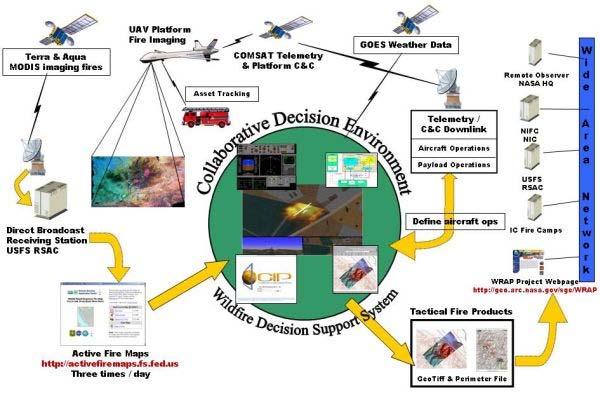
14 Intelligent Mission Management + Wildfire Research Applications Partnership Low-res MODIS thermal/fire products UAS mission planning high-res multi-spectral UAS on-board-products delivered in real time to ground forces
15

16 Image credit: NASA/MODIS Rapid Response
17 Standards As we know from the Cubesat standard, standards enable and allow communities to form! Open Geospatial Consortium s Sensor Web Enablement (SWE) initiative ( Defines a set of services and standards Some have a reference implementation 52 North ( has an active development community and implementations
18 Implementation This is a good topic for community discussion! Public vs. Private? Open, Community-driven vs. Closed? Advantages and disadvantages to each approach They re not mutually exclusive Really, someone just needs to go first, so we can all learn from the experience
19 What is needed? Key enabling piece is a catalog or repository of spacecraft sensor capabilities Enables discovery of what s available, and how to contact / interact / make requests Part of the OGC SWE initiative
20 Path Forward We need to bring together a group of likeminded Cubesat developers/operators, Then implement a shared registry, And start testing!
21 Conclusion While the concept of many spacecraft participating in a sensorweb is not new, the capabilities and number of Cubesats now make it an exciting proposition. The Cubesat community stands to collectively benefit from participation in such a sensorweb. Use of standards, and instantiation of a sensor repository/catalog, are the key steps forward.

22 Thank you Questions?
Dr. Charles Watt. Educational Advancement & Innovation
 Dr. Charles Watt Educational Advancement & Innovation 1 21st Century Education What are the critical skills our undergraduate students need? Technical depth in a particular field Creativity and innovation
Innovative Uses of the Canisterized Satellite Dispenser (CSD)
") Innovative Uses of the Canisterized Satellite Dispenser (CSD) By Walter Holemans (PSC), Ryan Williams (PSC), Andrew Kalman (Pumpkin), Robert Twiggs (Moorehead State University), Rex Ridenoure (Ecliptic
Innovative Uses of the Canisterized Satellite Dispenser (CSD) By Walter Holemans (PSC), Ryan Williams (PSC), Andrew Kalman (Pumpkin), Robert Twiggs (Moorehead State University), Rex Ridenoure (Ecliptic
Achieving Science with CubeSats: Thinking Inside the Box
 SPACE STUDIES BOARD WATER SCIENCE AND TECHNOLOGY BOARD Achieving Science with CubeSats: Thinking Inside the Box Robyn Millan and the Committee on Achieving Science Goals with Cubesats Committee Chair:
Disruptive technologies and future trends of small satellites
 2016 SSTL Disruptive technologies and future trends of small satellites Luis Gomes Director of EO & science Surrey Satellite Technology Limited Radio Communication June 1978 2016 SSTL The DMC and RapidEye
GSAW 2014 Session 11C Current and Future Ground Systems for CubeSats Working Group
 Approved for Public Release GSAW 2014 Session 11C Current and Future Ground Systems for CubeSats Working Group Catherine Venturini, The Aerospace Corporation Thom McVittie, NASA/JPL-CalTech 21 January
The EO-1 Autonomous Sciencecraft
 The EO-1 Autonomous Sciencecraft Rob Sherwood, Steve Chien, Daniel Tran, Benjamin Cichy, Rebecca Castano, Ashley Davies, Gregg Rabideau August 16, 2007 Outline Spacecraft Autonomy Prototyping a Smart Sensor
Cyber-Physical Systems
 Cyber-Physical Systems Cody Kinneer Slides used with permission from: Dr. Sebastian J. I. Herzig Jet Propulsion Laboratory, California Institute of Technology Oct 2, 2017 The cost information contained
INTERNET OF THINGS IN SPACE
 INTERNET OF THINGS IN SPACE IWDK IoT Trends 3 May 2018, DOKK1, Aarhus 3 MAY 2018 ASSOCIATE PROFESSOR 2 2 / 0 5 / 2 0 1 THE INVENTION OF THE INTERNET 1957, the Soviet Union launched the world s first manmade
Platform Independent Launch Vehicle Avionics
 Platform Independent Launch Vehicle Avionics Small Satellite Conference Logan, Utah August 5 th, 2014 Company Introduction Founded in 2011 The Co-Founders blend Academia and Commercial Experience ~20 Employees
A Standardized Geometry For Space Access Ports
 A Standardized Geometry For Space Access Ports A New Standard for 6 and 12U CubeSat Components 21 APRIL 2016 DOV JELEN, PUMPKIN, INC 1 History : Early Standards CubeSat Design Specification (CDS) from
Space Technology Mission Directorate. NASA's Role in Small Spacecraft Technologies: Today and in the Future
 National Aeronautics and Space Administration Space Technology Mission Directorate NASA's Role in Small Spacecraft Technologies: Today and in the Future Presented by: Jim Reuter Deputy Associate Administrator
Highly-Integrated Design Approach for High-Performance CubeSats
 Highly-Integrated Design Approach for High-Performance CubeSats Austin Williams Tyvak Nano-Satellite Systems CubeSat Workshop San Luis Obispo, CA April 19 th, 2012 Commercial Electronics Evolution In last
CubeSat Standard Updates
 CubeSat Standard Updates Justin Carnahan California Polytechnic State University April 25, 2013 CubeSat Developers Workshop Agenda The CubeSat Standard CDS Rev. 12 to Rev. 13 Changes The 6U CubeSat Design
Ground Systems Department
 Current and Emerging Ground System Technologies Ground Systems Department Dr. E.G. Howard (NOAA, National Satellites and Information Services) Dr. S.R. Turner (The Aerospace Corporation, Engineering Technology
On Discriminating CubeSats Launched Together
 On Discriminating CubeSats Launched Together Michael Cousins SRI International 2008 CubeSat Developer s Workshop San Luis Obispo, California 1 CubeSat Discrimination Scope: Discuss and explore the problem
Space Challenges Preparing the next generation of explorers. The Program
 Space Challenges Preparing the next generation of explorers Space Challenges is the biggest free educational program in the field of space science and high technologies in the Balkans - http://spaceedu.net
CubeSat Proximity Operations Demonstration (CPOD) Mission Update Cal Poly CubeSat Workshop San Luis Obispo, CA
 Mission Update Cal Poly CubeSat Workshop San Luis Obispo, CA") CubeSat Proximity Operations Demonstration (CPOD) Mission Update Cal Poly CubeSat Workshop San Luis Obispo, CA 04-22-2015 Austin Williams VP, Space Vehicles ConOps Overview - Designed to Maximize Mission
CubeSat Proximity Operations Demonstration (CPOD) Mission Update Cal Poly CubeSat Workshop San Luis Obispo, CA 04-22-2015 Austin Williams VP, Space Vehicles ConOps Overview - Designed to Maximize Mission
KUTESat. Pathfinder. Presented by: Marco Villa KUTESat Project Manager. Kansas Universities Technology Evaluation Satellite
 KUTESat Kansas Universities Technology Evaluation Satellite Pathfinder Presented by: Marco Villa KUTESat Project Manager Cubesat Developers' Workshop - San Luis Obispo, CA - April 8-10, 2004 SUMMARY Objectives
Iridium NEXT SensorPODs: Global Access For Your Scientific Payloads
 Iridium NEXT SensorPODs: Global Access For Your Scientific Payloads 25 th Annual AIAA/USU Conference on Small Satellites August 9th 2011 Dr. Om P. Gupta Iridium Satellite LLC, McLean, VA, USA Iridium 1750
HICO Status and Operations
 HICO Status and Operations HICO Users Group 7-8 May 2014 Mary Kappus, HICO Facility Manager Naval Research Laboratory Washington, DC HICO Transition to NASA Tech Demo Phase 1 In September 2009 HICO began
Customer Showcase > Defense and Intelligence
 Customer Showcase Skyline TerraExplorer is a critical visualization technology broadly deployed in defense and intelligence, public safety and security, 3D geoportals, and urban planning markets. It fuses
NASA s Earth Science Technology Office CubeSats for Technology Maturation
 NASA s Earth Science Technology Office CubeSats for Technology Maturation Charles D. Norton NASA HQ Earth Science Technology Office (ESTO) Jet Propulsion Laboratory, California Institute of Technology
Beyond CubeSats: Operational, Responsive, Nanosatellite Missions. 9th annual CubeSat Developers Workshop
 Beyond CubeSats: Operational, Responsive, Nanosatellite Missions 9th annual CubeSat Developers Workshop Jeroen Rotteveel Nanosatellite Applications Nanosatellite Market growing rapidly Cubesats: Conception
The COVE Payload A Reconfigurable FPGA-Based Processor for CubeSats
 The COVE Payload A Reconfigurable FPGA-Based Processor for CubeSats Paula Pingree Dmitriy Bekker Thomas Werne Thor Wilson Brian Franklin Jet Propulsion Laboratory August 8, 2010 Small Satellite Conference
Using Freely Available. Remote Sensing to Create a More Powerful GIS
 Using Freely Available Government Data and Remote Sensing to Create a More Powerful GIS All rights reserved. ENVI, E3De, IAS, and IDL are trademarks of Exelis, Inc. All other marks are the property of
1 Introduction. Autonomous Response in an Autonomous Earth Observing Sensorweb
 Autonomous Response in an Autonomous Earth Observing Sensorweb Steve Chien, Ben Cichy, Ashley Davies, Daniel Tran, Gregg Rabideau, Rebecca Castano, Rob Sherwood, Son Nghiem Jet Propulsion Laboratory, California
NOAA Satellite Observing System Architecture (NSOSA) Study Update
 Study Update") NOAA Satellite Observing System Architecture (NSOSA) Study Update Dr. Karen St. Germain Director NOAA/NESDIS Office of System Architecture and Advanced Planning (OSAAP) Spring 2017 Meeting of the Committee
NOAA Satellite Observing System Architecture (NSOSA) Study Update Dr. Karen St. Germain Director NOAA/NESDIS Office of System Architecture and Advanced Planning (OSAAP) Spring 2017 Meeting of the Committee
NASA Mission to MARS Program Innovative DC Microgrid Proof of Concept for Spacecraft
 NASA Mission to MARS Program Innovative DC Microgrid Proof of Concept for Spacecraft Bob Stuart Masoud Nazari i-pcgrid Conference San Francisco March 25, 2015 Space Grid Management for Human Deep Exploration
UNCLASSIFIED. InnoVision Overview. Theron Anders 16 April 2008 Precision Strike Annual Programs Review UNCLASSIFIED
 InnoVision Overview Theron Anders 16 April 2008 Precision Strike Annual Programs Review 1 Functional Manager for NSG RDT&E InnoVision is the Functional Manager for the National System for Geospatial Intelligence
NASA s X2000 Program - an Institutional Approach to Enabling Smaller Spacecraft
 NASA s X2000 Program - an Institutional Approach to Enabling Smaller Spacecraft Dr. Leslie J. Deutsch and Chris Salvo Advanced Flight Systems Program Jet Propulsion Laboratory California Institute of Technology
Automated Damage Analysis from Overhead Imagery
 Automated Damage Analysis from Overhead Imagery EVAN JONES ANDRE COLEMAN SHARI MATZNER Pacific Northwest National Laboratory 1 PNNL FY2015 at a Glance $955 million in R&D expenditures 4,400 scientists,
Interplanetary CubeSat Launch Opportunities and Payload Accommodations
 Interplanetary CubeSat Launch Opportunities and Payload Accommodations Roland Coelho, VP Launch Services Tyvak Nano-Satellite Systems Inc. +1(805) 704-9756 roland@tyvak.com Partnered with California Polytechnic
JPL Does Cubesats. Tony Freeman* Manager, Innova1on Foundry. April 2013
 JPL Does Cubesats Tony Freeman* Manager, Innova1on Foundry April 2013 With a lot of help from the Cubesat Kitchen Cabinet: C. Norton (3X/8X), J. Baker (4X/6X), A. Gray (7X), L. Deutsch (9X) Explorer 1
FLIGHT SUMMARY REPORT
 FLIGHT SUMMARY REPORT Flight Number: 97-011 Calendar/Julian Date: 23 October 1996 297 Sensor Package: Area(s) Covered: Wild-Heerbrugg RC-10 Airborne Visible and Infrared Imaging Spectrometer (AVIRIS) Southern
The Evolution of Nano-Satellite Proximity Operations In-Space Inspection Workshop 2017
 The Evolution of Nano-Satellite Proximity Operations 02-01-2017 In-Space Inspection Workshop 2017 Tyvak Introduction We develop miniaturized custom spacecraft, launch solutions, and aerospace technologies
SPACE DOMAIN AWARENESS: A GLOBAL CHALLENGE. Konichiwa and thank you Yoshitomi-San for that very kind
 SPACE DOMAIN AWARENESS: A GLOBAL CHALLENGE Konichiwa and thank you Yoshitomi-San for that very kind introduction. It is great to be back in Japan and I look forward to the opportunity of seeing many great
Wide-area Motion Imagery for Multi-INT Situational Awareness
 Wide-area Motion Imagery for Multi-INT Situational Awareness Bernard V. Brower Jason Baker Brian Wenink Harris Corporation TABLE OF CONTENTS ABSTRACT... 3 INTRODUCTION WAMI HISTORY... 4 WAMI Capabilities
Developing a CubeSat Model-Based System Engineering (MBSE) Reference Model Interim Status #3
 Reference Model Interim Status #3") Developing a CubeSat Model-Based System Engineering (MBSE) Reference Model Interim Status #3 David Kaslow Consultant Berwyn, PA 19312 610-405-6685 david.kaslow@gmail.com Laura Hart The MITRE Corporation
Developing a CubeSat Model-Based System Engineering (MBSE) Reference Model Interim Status #3 David Kaslow Consultant Berwyn, PA 19312 610-405-6685 david.kaslow@gmail.com Laura Hart The MITRE Corporation
CPE/CSC 580: Intelligent Agents
 CPE/CSC 580: Intelligent Agents Franz J. Kurfess Computer Science Department California Polytechnic State University San Luis Obispo, CA, U.S.A. 1 Course Overview Introduction Intelligent Agent, Multi-Agent
The Moderate Resolution Imaging Spectroradiometer (MODIS): Potential Applications for Climate Change and Modeling Studies
: Potential Applications for Climate Change and Modeling Studies") The Moderate Resolution Imaging Spectroradiometer (MODIS): Potential Applications for Climate Change and Modeling Studies Menas Kafatos, CEOSR, George Mason University Jim McManus, CEOSR, GMU and GES DISC
The Moderate Resolution Imaging Spectroradiometer (MODIS): Potential Applications for Climate Change and Modeling Studies Menas Kafatos, CEOSR, George Mason University Jim McManus, CEOSR, GMU and GES DISC
PolySat Launch and Operations
 PolySat Launch and Operations Cubesat Developers Summer Workshop Logan, Utah 12 August 2007 PolySat Objective: Engineering Education Objective: Provide a reliable bus system to allow for flight qualification
A High-Speed Data Downlink for Wide-Bandwidth CubeSat Payloads
 A High-Speed Data Downlink for Wide-Bandwidth CubeSat Payloads John Buonocore 12 th Annual Developer s Workshop 22 April 2015 Cal Poly San Luis Obispo High Speed Data Downlink The need for wider bandwidth
The M-Cubed/COVE Mission
 The M-Cubed/COVE Mission Matt Bennett 1, Andrew Bertino 2, James Cutler 2, Charles Norton 1, Paula Pingree 1, John Springmann 2, Scott Tripp 2 CubeSat Developers Workshop April 18, 2012 1 Jet Propulsion
Validation and Verification of MBSE-compliant CubeSat Reference Model
 15 th Annual Conference on Systems Engineering Research Disciplinary Convergence: Implications for Systems Engineering Research Eds.: Azad M. Madni, Barry Boehm Daniel A. Erwin, Roger Ghanem; University
RAX: The Radio Aurora explorer
 RAX: Matt Bennett University of Michigan CubeSat Workshop Cal Poly, San Luis Obispo April 22 nd, 2009 Background Sponsored by National Science Foundation University of Michigan and SRI International Collaboration
THE ROLE OF UNIVERSITIES IN SMALL SATELLITE RESEARCH
 THE ROLE OF UNIVERSITIES IN SMALL SATELLITE RESEARCH Michael A. Swartwout * Space Systems Development Laboratory 250 Durand Building Stanford University, CA 94305-4035 USA http://aa.stanford.edu/~ssdl/
Microwave Radiometers for Small Satellites
 Microwave Radiometers for Small Satellites Gregory Allan, Ayesha Hein, Zachary Lee, Weston Marlow, Kerri Cahoy MIT STAR Laboratory Daniel Cousins, William J. Blackwell MIT Lincoln Laboratory This work
Fundamentals of Remote Sensing
 Climate Variability, Hydrology, and Flooding Fundamentals of Remote Sensing May 19-22, 2015 GEO-Latin American & Caribbean Water Cycle Capacity Building Workshop Cartagena, Colombia 1 Objective To provide
Making it Small. April 22-24, 24, Cal Poly Developers Workshop California State Polytechnic University San Luis Obispo, CA
 Making it Small April 22-24, 24, 2009 2009 Cal Poly Developers Workshop California State Polytechnic University San Luis Obispo, CA Prof. Bob Twiggs Bob.Twiggs@Stanford.Edu What started the miniaturization
Scientific Data e-infrastructures in the European Capacities Programme
 Scientific Data e-infrastructures in the European Capacities Programme PV 2009 1 December 2009, Madrid Krystyna Marek European Commission "The views expressed in this presentation are those of the author
Wide-Area Motion Imagery for Multi-INT Situational Awareness
 Bernard V. Brower (U.S.) Jason Baker (U.S.) Brian Wenink (U.S.) Harris Corporation Harris Corporation Harris Corporation bbrower@harris.com JBAKER27@harris.com bwenink@harris.com 332 Initiative Drive 800
Littoral Operations Center Overview. OpTech East 1 December 2015
 Littoral Operations Center Overview OpTech East 1 December 2015 While staying grounded in tactics and operations, the LOC: Seeks to apply science and technology to better enable littoral operations in
Deep Space cubesats a nanosats at JPL. Tony Freeman Jet Propulsion Laboratory, California Institute of Technology
 Deep Space cubesats a nanosats at JPL Tony Freeman Jet Propulsion Laboratory, California Institute of Technology Cubesats and Nanosats at JPL Overview JPL is known for its flagship missions to explore
The Hawaii Space Flight Laboratory and the LEONIDAS Program
 The Hawaii Space Flight Laboratory and the LEONIDAS Program Program Summary and Goals Reaching for the Stars: NextGen Aviation and Space Launch August 21, 2008 Dr. Luke Flynn Director: HSFL & HSGC Luke.Flynn@hsfl.hawaii.edu
Detection and Monitoring Through Remote Sensing....The Need For A New Remote Sensing Platform
 WILDFIRES Detection and Monitoring Through Remote Sensing...The Need For A New Remote Sensing Platform Peter Kimball ASEN 5235 Atmospheric Remote Sensing 5/1/03 1. Abstract This paper investigates the
CubeSat Integration into the Space Situational Awareness Architecture
 CubeSat Integration into the Space Situational Awareness Architecture Keith Morris, Chris Rice, Mark Wolfson Lockheed Martin Space Systems Company 12257 S. Wadsworth Blvd. Mailstop S6040 Littleton, CO
A Failure Analysis of the ExoCube CubSat. 13 th Annual Cubesat Workshop San Luis Obispo, CA Wednesday, April 20 th, 2016
 A Failure Analysis of the ExoCube CubSat 13 th Annual Cubesat Workshop San Luis Obispo, CA Wednesday, April 20 th, 2016 1 Background To characterize Hydrogen, Helium, Nitrogen and Oxygen, ions and neutrals
Autonomous Control for Unmanned
 Autonomous Control for Unmanned Surface Vehicles December 8, 2016 Carl Conti, CAPT, USN (Ret) Spatial Integrated Systems, Inc. SIS Corporate Profile Small Business founded in 1997, focusing on Research,
CubeSat Developers Workshop 2014
 CubeSat Developers Workshop 2014 IPEX Intelligent Payload EXperiment Eric Baumgarten 4/23/14 CubeSat Workshop 2014 1 IPEX Mission Summary 1U Cubesat in collaboration with JPL Cal Poly s PolySat constructed
PASSIVE MICROWAVE PROTECTION
 PASSIVE MICROWAVE PROTECTION RESULTS OF WRC-07 DISASTER MANGEMENT FUTURE WORK FOR WRC-11, RFI INTERFERENCE ON SATELLITE PASSIVE OBSERVATIONS Jean PLA CNES, Toulouse, France Frequency manager 1 Agenda items
Textbook, Chapter 15 Textbook, Chapter 10 (only 10.6)
") AGOG 484/584/ APLN 551 Fall 2018 Concept definition Applications Instruments and platforms Techniques to process hyperspectral data A problem of mixed pixels and spectral unmixing Reading Textbook, Chapter
AGOG 484/584/ APLN 551 Fall 2018 Concept definition Applications Instruments and platforms Techniques to process hyperspectral data A problem of mixed pixels and spectral unmixing Reading Textbook, Chapter
Onboard Mission Planning on the Intelligent Payload Experiment (IPEX) Cubesat Mission
 Cubesat Mission") Appears in Proc. International Workshop on Planning and Scheduling for Space, Moffett Field, CA, March 2013. Onboard Mission Planning on the Intelligent Payload Experiment (IPEX) Cubesat Mission Steve
Appears in Proc. International Workshop on Planning and Scheduling for Space, Moffett Field, CA, March 2013. Onboard Mission Planning on the Intelligent Payload Experiment (IPEX) Cubesat Mission Steve
Satellite Advances in New Mexico
 Satellite Advances in New Mexico Dr. Steve Suddarth Director (505) 803-2684 Director@fpgamac.org Prof. Christos Christodoulou Chief Research Officer (505) 277-6580 Christos@ece.unm.edu Craig Kief Deputy
New Technologies for Future EO Instrumentation Mick Johnson
 New Technologies for Future EO Instrumentation Mick Johnson Director of CEOI Monitoring the Earth from Space What data do EO satellites provide? Earth Observation science Operational services Weather,
Hyperspectral Imagery: A New Tool For Wetlands Monitoring/Analyses
 WRP Technical Note WG-SW-2.3 ~- Hyperspectral Imagery: A New Tool For Wetlands Monitoring/Analyses PURPOSE: This technical note demribea the spectral and spatial characteristics of hyperspectral data and
Strategies for Successful CubeSat Development. Jordi Puig-Suari Aerospace Engineering Department Cal Poly, San Luis Obispo CEDAR Workshop July, 2009
 Strategies for Successful CubeSat Development Jordi Puig-Suari Aerospace Engineering Department Cal Poly, San Luis Obispo CEDAR Workshop July, 2009 1 Some CubeSat Facts Over 100 Developers Worldwide Including
Introduction. digitalsupercluster.ca
 Introduction digitalsupercluster.ca Government of Canada s Innovation Supercluster Initiative Federal government investing $950MM into superclusters to drive growth, prosperity, jobs and global leadership.
The Space Portal A Framework for Exploration and Development
 The Space Portal A Framework for Exploration and Development Daniel J. Rasky, PhD Chief Space Portal Office Partnerships Directorate Daniel.J.Rasky@nasa.gov August 17, 2016 1 A New Entrepreneurial Paradigm
Durham Research Online
 Durham Research Online Deposited in DRO: 29 August 2017 Version of attached le: Accepted Version Peer-review status of attached le: Not peer-reviewed Citation for published item: Chiu, Wei-Yu and Sun,
Multispectral Scanners for Wildland Fire Assessment NASA Ames Research Center Earth Science Division. Bruce Coffland U.C.
 Multispectral Scanners for Wildland Fire Assessment NASA Earth Science Division Bruce Coffland U.C. Santa Cruz Slide Fire Burn Area (MASTER/B200) R 2.2um G 0.87um B 0.65um Airborne Science & Technology
KNOWLEDGE ASSOCIATES INTERNATIONAL
 KNOWLEDGE ASSOCIATES INTERNATIONAL ST JOHN S INNOVATION CENTRE, CAMBRIDGE, UK EUROPE. ASIA. USA. RUSSIA MOVING FORWARD WITH GLOBAL KNOWLEDGE SOUTH AFRICAN KNOWLEDGE MANAGEMENT SUMMIT, SANDTON, 30 th August
Ph.D. Student, Aerospace and Mechanical Engineering Department, College of Engineering, The University of Arizona, Tucson, AZ,
 Leveraging the Emerging CubeSat Reference Model for Space Situational Awareness Aman Chandra 1 The University of Arizona, achandra@email.arizona.edu Mostafa Lutfi 2 The University of Arizona, mostafalutfi@email.arizona.edu
RAX: Lessons Learned in Our Spaceflight Endeavor
 RAX: Lessons Learned in Our Spaceflight Endeavor Matt Bennett University of Michigan CubeSat Workshop Cal Poly, San Luis Obispo April 21 st, 2010 Background Sponsored by National Science Foundation University
In the summer of 2002, Sub-Orbital Technologies developed a low-altitude
 1.0 Introduction In the summer of 2002, Sub-Orbital Technologies developed a low-altitude CanSat satellite at The University of Texas at Austin. At the end of the project, team members came to the conclusion
Autonomy and Sensor Webs: The Evolution of Mission Operations
 SpaceOps 2008 Conference (Hosted and organized by ESA and EUMETSAT in association with AIAA) AIAA 2008-3296 Autonomy and Sensor Webs: The Evolution of Mission Operations Rob Sherwood 1 Jet Propulsion Laboratory,
CATLIN SEAVIEW SURVEY PUBLISHES GAME- CHANGING VISUAL RECORD OF GREAT BARRIER REEF
 PRESS RELEASE For immediate release CATLIN SEAVIEW SURVEY PUBLISHES GAME- CHANGING VISUAL RECORD OF GREAT BARRIER REEF IMAGES ALSO RELEASED IN STREET VIEW IN GOOGLE MAPS More than 100,000 images spanning
Technical Committee Report International Spaceborne Imaging Spectroscopy
 Slide 1 Geoscience and Remote Sensing Society Technical Committee Report International Spaceborne Imaging Spectroscopy Cindy Ong, CSIRO Andreas Mueller, DLR, Uta Heiden, DLR GRSS AdCom Meeting Washington,
PROCEEDINGS OF SPIE. Inter-satellite omnidirectional optical communicator for remote sensing
 PROCEEDINGS OF SPIE SPIEDigitalLibrary.org/conference-proceedings-of-spie Inter-satellite omnidirectional optical communicator for remote sensing Jose E. Velazco, Joseph Griffin, Danny Wernicke, John Huleis,
Integration and Test of the Microwave Radiometer Technology Acceleration (MiRaTA) CubeSat
 CubeSat") Integration and Test of the Microwave Radiometer Technology Acceleration (MiRaTA) CubeSat Kerri Cahoy, Gregory Allan, Ayesha Hein, Andrew Kennedy, Zachary Lee, Erin Main, Weston Marlow, Thomas Murphy MIT
Integration and Test of the Microwave Radiometer Technology Acceleration (MiRaTA) CubeSat Kerri Cahoy, Gregory Allan, Ayesha Hein, Andrew Kennedy, Zachary Lee, Erin Main, Weston Marlow, Thomas Murphy MIT
Development of Random Vibration Profiles for Test Deployers to Simulate the Dynamic Environment in the Poly-Picosatellite Orbital Deployer
 Development of Random Vibration Profiles for Test Deployers to Simulate the Dynamic Environment in the Poly-Picosatellite Orbital Deployer Steve Furger California Polytechnic State University, San Luis
Remote Sensing Platforms
 Remote Sensing Platforms Remote Sensing Platforms - Introduction Allow observer and/or sensor to be above the target/phenomena of interest Two primary categories Aircraft Spacecraft Each type offers different
Service Robots in an Intelligent House
 Service Robots in an Intelligent House Jesus Savage Bio-Robotics Laboratory biorobotics.fi-p.unam.mx School of Engineering Autonomous National University of Mexico UNAM 2017 OUTLINE Introduction A System
Autonomous and Autonomic Systems: With Applications to NASA Intelligent Spacecraft Operations and Exploration Systems
 Walt Truszkowski, Harold L. Hallock, Christopher Rouff, Jay Karlin, James Rash, Mike Hinchey, and Roy Sterritt Autonomous and Autonomic Systems: With Applications to NASA Intelligent Spacecraft Operations
Space Exploration: From Science Fiction to the Texas Spacecraft Laboratory
 # 89 Space Exploration: From Science Fiction to the Texas Spacecraft Laboratory Dr. Glenn Lightsey March 1, 2014 Produced by and for Hot Science - Cool Talks by the Environmental Science Institute. We
Two- Stage Control for CubeSat Optical Communications
 Two- Stage Control for CubeSat Optical Communications Ryan W. Kingsbury Kathleen Riesing, Tam Nguyen, Prof. Kerri Cahoy MIT Space Systems Lab CalPoly CubeSat Developers Workshop April 24, 2014 Outline
Benefits analysis. Benefit categorisation. Lesley Murphy QinetiQ. ESA Space Weather Programme study Final presentation, 6th-7th December 2001
 Benefits analysis Lesley Murphy QinetiQ ESA Space Weather Programme study Final presentation, 6th-7th December 2001 Benefit categorisation STRATEGIC - affecting Europe s industrial, military, technological
21 st Century Skills. Describe how satellite data is transmitted from space to Earth,
 Level of Difficulty: 4 Grade Range: 9-12 Activity Time: 45-60 min Business Category: IT Topic: Information and Communication OVERVIEW Information and Communication In this lesson, students will explore
United nation, Vienna, 9-13 February 2015
 United nation, Vienna, 9-13 February 2015 RUSSIAN FEDERAL SPACE AGENCY In the Russian Federation, the federal agency in charge of space activities is the Russian Federal Space Agency (Roscosmos) Earth
Scale of the Opportunity. Dr. Jaime Reed, Space Growth Partnership
 Scale of the Opportunity Dr. Jaime Reed, Space Growth Partnership Space : still young, still changing What s the next big leap in transforming our world? 1950s 1960s 1970s 1980s 1990s 2010s Core space
ISS Program.
 ISS Program www.questforspace.com International Space Station (ISS): A microgravity laboratory in which an international crew of six people live and work while traveling at a speed of five miles per second,
A CubeSat-Based Optical Communication Network for Low Earth Orbit
 A CubeSat-Based Optical Communication Network for Low Earth Orbit Richard Welle, Alexander Utter, Todd Rose, Jerry Fuller, Kristin Gates, Benjamin Oakes, and Siegfried Janson The Aerospace Corporation
CubeSat Model-Based System Engineering (MBSE) Reference Model Development and Distribution Interim Status
 Reference Model Development and Distribution Interim Status") CubeSat Model-Based System Engineering (MBSE) Reference Model Development and Distribution Interim Status David Kaslow 1 Consultant, Berwyn, PA 19312 USA Bradley J. Ayres 2 The Aerospace Corporation, Wright
CubeSat Model-Based System Engineering (MBSE) Reference Model Development and Distribution Interim Status David Kaslow 1 Consultant, Berwyn, PA 19312 USA Bradley J. Ayres 2 The Aerospace Corporation, Wright
Earth Observations from Space U.S. Geological Survey
 Earth Observations from Space U.S. Geological Survey Geography Land Remote Sensing Program Dr. Bryant Cramer April 1, 2009 U.S. Department of the Interior U.S. Geological Survey USGS Landsat Historical
Earth Cube Technical Solution Paper the Open Science Grid Example Miron Livny 1, Brooklin Gore 1 and Terry Millar 2
 Earth Cube Technical Solution Paper the Open Science Grid Example Miron Livny 1, Brooklin Gore 1 and Terry Millar 2 1 Morgridge Institute for Research, Center for High Throughput Computing, 2 Provost s
THE NOAA SATELLITE OBSERVING SYSTEM ARCHITECTURE STUDY
 THE NOAA SATELLITE OBSERVING SYSTEM ARCHITECTURE STUDY Dr. Karen St. Germain, NOAA/NESDIS Dr. Mark Maier, The Aerospace Corporation Dr. Frank W. Gallagher III, NOAA/NESDIS ABSTRACT NOAA is conducting a
Human Exploration Systems and Mobility Capability Roadmap. Chris Culbert, NASA Chair Jeff Taylor, External Chair
 Human Exploration Systems and Mobility Capability Roadmap Chris Culbert, NASA Chair Jeff Taylor, External Chair 1 Human Exploration Systems and Mobility Capability Roadmap Team Co-Chairs NASA: Chris Culbert,
QUEST Vision for Exploration of Space
 QUEST for Human Exploration of the Solar System GSAW99 NASA/JSC/Lynn R. Vernon 1 Why are we Here? Present a vision of the Ground and Space architecture to support the Human exploration of space. Develop
Southern Africa Fire Network overview
 Southern Africa Fire Network overview - 2017 Estimation of live fuel moisture content Implementation of Dr Marta Yebra s FMC algorithm Currently running om MODIS MCD 43 c6 Applied on Sentinel 2 and
NOAA EON-IR CubeSat Study for Operational Infrared Soundings
 NOAA EON-IR CubeSat Study for Operational Infrared Soundings Dan Mamula National Oceanic and Atmospheric Administration National Environmental Satellite, Data, and Information Service Office of Project,
AGING IN PLACE WORKSHOP
 AGING IN PLACE WORKSHOP At the National Institutes of Health September 9-10 th, 2014 Wendy Nilsen, PhD Office of Behavioral and Social Sciences Research BACKGROUND Workshop designed to assess the state