OEM Done Right: Hemisphere GNSS & Carlson Software Bring Lightweight, State-of-the-Art Receivers to Market
|
|
|
- Holly Poppy Oliver
- 5 years ago
- Views:
Transcription
1


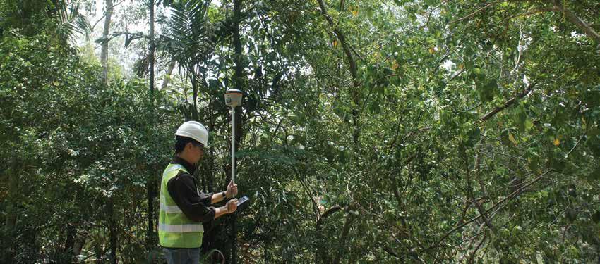
2 OEM Done Right: Hemisphere GNSS & Carlson Software Bring Lightweight, State-of-the-Art Receivers to Market For land surveyors and others in careers that rely on constant use of GPS and GNSS technology, not to mention the millions of consumers with receivers in their smart phones, it is easy to forget that instant location remains technologically miraculous, relying as it does on satellites, specialized receivers and chips, and even on the relativistic equations discovered by Albert Einstein. Somehow, precise location has become so ubiquitous and functional that most of us take it for granted. In other words, GNSS has become an exceedingly mature technology, and that creates challenges for Hemisphere GNSS engineers. It is no longer enough simply to provide accurate positioning anywhere in the world users of GNSS receivers now expect lightweight, easy-to-use receivers that are optimized for their particular workflows so they can work efficiently and precisely and prices should be reasonable, too. Meanwhile, the equipment manufacturing process also has matured; design and production of sophisticated instruments, from concept to market, now takes months rather than years, and relies on global teams of networked specialists. One of the biggest challenges for us, and potential benefits for our partners, is to focus on working with them to quickly deliver the performance and features that they need, says Hemisphere Senior Product Manager Lyle Geck. If we do that well, we know we re going to make a very good receiver that will be reliable and state-of-the-art in many situations.
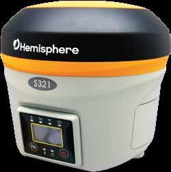
3 These were the challenges and opportunities on the table when Carlson Software approached Hemisphere in early 2015 they had decided to bring a new GNSS receiver to market, a receiver optimized for land surveyors and genuinely state-of-the-art in terms of precision, convenience, and form factor. We work closely with land surveyors, and we definitely saw a need, says Carlson s Director of Special Projects Karl Nicholas. For one thing, our clients were asking for smaller and lighter receivers. And we also felt that a new receiver could be better optimized to work with the multiple satellite constellations now available, and with the array of RTK solutions that surveyors use routinely. Hemisphere recognized that a new lightweight receiver would also serve their marine clients well, especially if it was optimized to work seamlessly with their Atlas GNSS Global Correction Service, as a rover, and as a base station. This was definitely a case where taking on an OEM (original equipment manufacturer) project could serve the needs of two companies and several end-user niches. The result, a few months later, was Carlson s new BRx6 and Hemisphere s new S321 GNSS receivers, both now available. The design and delivery process responsible for that rapid production process is quite interesting. Since 1983, Carlson has focused on, CAD design software, field data collection, and machine control products for the land surveying, civil engineering, construction, and mining industries worldwide, while also developing a renowned real-time customer service system. Becoming a hardware company might dilute this focus, so it made sense for them to work with Hemisphere on the design and manufacturing of the new receiver. From Hemisphere s point of view, they were getting access to a deep knowledge base of how surveyors work with GNSS in real-world conditions, and how to optimize a new receiver for fieldwork of all kinds. This Carlson-provided expertise helped them make decisions about interface, form factor, and features, and that definitely made the S321 better in the field. And it helped that Carlson had previously worked with Hemisphere when designing and producing their groundbreaking BRx5 GNSS receiver (equivalent to Hemisphere s S320), as well as rugged components for their machine control business. It made sense to work with them again. We like working with Hemisphere, says Nicholas. They re committed to being a world-class provider of dual-frequency precision receivers, and they have a thorough understanding of the way precision corrections work due to their Atlas GNSS global correction service. So we came to an arrangement that allowed each firm to focus on our respective core expertise it s a very logical relationship, and definitely a win/win that drives growth for both firms. And most importantly, it made sense for our customers because it was the fastest way to make a truly innovative receiver.


4 Customer Focus We are not a take it or leave it company, says Geck. For us, it starts with a conversation, and the conversation never really ends. We want our OEM partners to find us flexible and accommodating. In this case, Carlson was the partner, but Hemisphere saw an opportunity to serve several niche markets; Carlson and their land surveying clients, and Hemisphere s own marine survey and OEM construction clients. Hemisphere s conversations with Carlson started in May 2015 and continued for months as specifications for particular functions and features were identified, and as various prototypes became available for testing and feedback. Specifications included: Compact, Durable, and Sturdy: Carlson s BRx5 receiver (Hemisphere S320) is not bulky by any measure. But technology marches on, and both companies knew that customers were very interested in even lighter and more compact receivers, so that was a high priority. In a development that was fortunate for both Carlson and Hemisphere, a form factor for a smaller receiver had already been developed. Our hardware design and manufacturing division located in China presented a hardware design that we really liked, so we didn t have to redesign from scratch in that area, Geck explains. It was a good design for Carlson and for us, so we were able to move ahead with only minor modifications. This is a good example of the way global partners are able to work together synergistically. Carlson, of course, did due diligence before signing off on the hardware design. I ve tested it, Nicholas says cheerfully. I put mine on top of a two-meter pole and dropped it onto concrete and dirt, and I also tried it out in wet weather worked fine!

5 Multiple Satellite Constellations: There are simply more satellite constellations available now, and they can be used to provide better accuracy and more efficient field work, Nicholas says. In the BRx6, we have a receiver that works seamlessly right now with GPS, GLONASS, and the Chinese BeiDou system. And when Europe s Galileo system becomes available, we ll be ready for it too. The Art of RTK Performance and Multiple Correction Sources: From Carlson s point of view, Hemisphere s RTK algorithm expertise was a big advantage of the partnership. Athena, Hemisphere s RTK engine is designed from the ground up to efficiently process the new constellations and signals with high-accuracy performance. And of course, in addition to traditional RTK correction methods using NTRIP and UHF/900 MHz radios, Hemisphere also provides Atlas, their own L-band correction service. Atlas is a subscription-based, extremely flexible, globally available (from 75ºN to 75ºS, covering all the Earth s landmass) correction service that relies on approximately 200 reference stations worldwide to provide up to sub-decimeter accuracies via L-band satellites or over the internet. For surveyors and Hemisphere s marine clients, that means correction accuracy sufficient for most field work is available in any region, even where other RTK networks are not available, or are compromised. Detailed testing performed by Carlson shows that Athena is a world-class RTK engine, says Nicholas. The S321 was also designed with a built-in UHF radio, and multiple wireless communication ports to enable corrections via radio, cellular modem, Wi-Fi, Bluetooth, or serial connections.


6 Base Station Capacity: The S321 and BRx6 are not just lightweight, high-precision rovers; they also are able to serve as highly capable base stations. We were as motivated as Carlson to make this receiver work well as a base station, Geck says. For our marine clients, this receiver is actually more likely to be used as a base station. For Hemisphere, a typical use case for the S321 is to be set up in a port and used as a base for construction or other maritime operations, and Carlson also saw the need for at least occasional use as a base in construction and surveying operations. Accordingly, the Atlas-enabled S321 can be set up, basically, anywhere, and together with Hemisphere s BaseLink technology, serve as an accurate base station. It isn t a closed system, Geck says. It works well with Atlas of course, but other protocols, like TrimTalk, are supported as well and external radios can be connected as needed. And we built an internet-based control system, webui, in as well so once it s set up as a base, the BRx6 can be monitored and operated from a construction trailer or from the field. Productivity: Innovations that boosted field productivity were an important part of Carlson s contributions to the receiver design process their decades of experience designing tools and interfaces for working land surveyors gives the company deep knowledge of productive workflows, and we ve built that knowledge into the S321. For example, We worked with Hemisphere to add accelerometers and a compass and a tilt sensor, Nicholas says. So the receiver knows if the pole is vertical, and how it s oriented horizontally, and can correct for those factors. And it s also handy for things like stakeouts, and recovering points the unit can direct you to the next point, graphically, which saves time.


7 The new receiver s SureFix technology is another good example of a productivity feature. It s common for surveyors to be working in areas with lots of trees, buildings, and other obstructions, Geck explains. In those conditions, position reliability will often degrade. Surveyors are aware of this, but it s hard to compensate when they don t have information about just what s happening with accuracy. SureFix uses proprietary algorithms and various inputs to give a quality indicator for particular points. In other words, SureFix can raise confidence when shooting in difficult multi-path conditions, or let a surveyor know when he needs to slow down to get the precision he needs. This improves fieldwork, and can eliminate trips back to the field to correct errors. This is a great feature, and we re pushing it, Nicholas says. One of the really nice things about SureFix is it lets surveyors know if they have the accuracy they need before they leave a point. And if they really need an ultra-precise location, SureFix will let them know to stay a little longer until they have it. Our customers appreciate that kind of information. As part of the development process, Carlson and Nicholas personally tested features like this. We verified that it really does make a big difference when working around trees and other obstructions. Better Together The S321 and BRx6 s design and manufacturing process is a good example of the synergies available when partners work together. Carlson Software was able to leverage its 30+ years of experience in land surveying, and Hemisphere GNSS added manufacturing experience and world-class GNSS and RTK expertise. The result for their respective customers is a compact, state-of-the-art receiver that is perfectly tuned for the requirements and workflows of their daily projects.

8
Global Correction Services for GNSS
 Global Correction Services for GNSS Hemisphere GNSS Whitepaper September 5, 2015 Overview Since the early days of GPS, new industries emerged while existing industries evolved to use position data in real-time.
When do you expect Athena to be available for VS330? This is currently being beta-tested and will be released in the very near future.
 Why Athena? Athena GNSS Engine What improvements does Athena offer over the RTK firmware I m running now? Compared to the Hemisphere firmware most users are currently using (Qf4), there are significant
One Source for Positioning Success
 novatel.com One Source for Positioning Success RTK, PPP, SBAS OR DGNSS. NOVATEL CORRECT OPTIMIZES ALL CORRECTION SOURCES, PUTTING MORE POWER, FLEXIBILITY AND CONTROL IN YOUR HANDS. NovAtel CORRECT is the
SL 300 GNSS Receiver. w w w. s a t l a b g p s. c o m
 SL 300 GNSS Receiver w w w. s a t l a b g p s. c o m SL 300 6G GNSS Receiver The Ultimate Expandable Handheld Smart GNSS Sensor with 6G Tracking European Standards Lightweight Bluetooth GPS GLONASS BEIDOU
DEFINING THE FUTURE OF SATELLITE SURVEYING WITH TRIMBLE R-TRACK TECHNOLOGY
 DEFINING THE FUTURE OF SATELLITE SURVEYING WITH TRIMBLE R-TRACK TECHNOLOGY EDMOND NORSE, GNSS PORTFOLIO MANAGER, TRIMBLE SURVEY DIVISION WESTMINSTER, CO USA ABSTRACT In September 2003 Trimble introduced
SL 300 GNSS Receiver. w w w.sa tla b g p s. c o m
 SL 300 GNSS Receiver w w w.sa tla b g p s. c o m SL 300 GNSS Receiver The Ultimate Expandable Handheld Smart GNSS Sensor with Multi Constellation Tracking European Standards Lightweight Bluetooth Multi
AGENDA. NEI Overview. Mobile platforms with the new R1 / R2 GNSS receiver. High Accuracy Cloud Based Data Collection. Geo 7X Higher Accuracy Option
 AGENDA NEI Overview Mobile platforms with the new R1 / R2 GNSS receiver High Accuracy Cloud Based Data Collection Geo 7X Higher Accuracy Option Selecting - the Right Tool for the Right Job Field to Finish.
Sokkia GNSS Receiver. Product Portfolio. Price GRX2 GCX2. GHX2 MESA Field Tablet SA300 S-10. Features
 Only from Sokkia GNSS Receiver Price Product Portfolio GRX2 GCX2 S-10 GHX2 MESA Field Tablet SA300 Features Product Overview Smallest and lightest GNSS integrated receiver Innovative and ergonomic shape
GeoMax GNSS. Zenith35 Pro Series. Product Presentation V 3.0
 GeoMax GNSS Zenith35 Pro Series Product Presentation V 3.0 GeoMax Zenith35 Pro Series Table of Contents Receiver Overview Specs Options GeoMax Geo Office Datalogger Field Software Packages Promotion Material
Professional GNSS solutions in challenging environments
 Professional GNSS solutions in challenging environments Company history 2000 Septentrio is founded as a spin-off from IMEC, world s premier semiconductor research center and still a strong partner & shareholder.
GNSS Receivers, Sensors, Desktop Solutions
 GNSS Receivers, Sensors, Desktop Solutions keep it simple high performance: the best GNSS tracking in field ready, reliable packages coupled with the best field and desktop software tools support and service
CAESultra for Mining. Machine Compatibility. Shovels, Motor Graders, Hydraulic Excavators, Track-Type Tractors
 CAESultra for Mining Machine Compatibility Machine Family Scrapers, Loaders, Dozers, Shovels, Motor Graders, Hydraulic Excavators, Track-Type Tractors CAESultra for Mining CAESultra for Mining is a versatile
Indian Institute of Technology Kanpur Department of Civil Engineering
 Indian Institute of Technology Kanpur Department of Civil Engineering Inquiry No- CE/JNM/2013-14/R-10 30 December, 2013 Subject: Quotation for supply of Integrated System/Smart System Reflectorless Robotic
Introduction to Total Station and GPS
 Introduction to Total Station and GPS Dr. P. NANJUNDASWAMY Professor of Civil Engineering J S S Science and Technology University S J College of Engineering Mysuru 570 006 Introduction History GPS Overview
Table of Contents Relay RTK Module...1
 Table of Contents Relay RTK Module...1 GPS 6500 RTK Relay 400/900 AutoBase with Saved Locations...1 Q: Is the GPS 6000 compatible with the RTK Relay Module?...5 What is GLIDE?...6 GPS 6500 RTK Relay Module
Motion & Navigation Solution
 Navsight Land & Air Solution Motion & Navigation Solution FOR SURVEYING APPLICATIONS Motion, Navigation, and Geo-referencing NAVSIGHT LAND/AIR SOLUTION is a full high performance inertial navigation solution
GPS + Glonass Using the Best of Both Worlds
 GPS + Glonass Using the Best of Both Worlds Jupiter SL869 Jupiter JN3 Jupiter SE880 IMPROVE TIME-TO-FIRST-FIX GET MORE ACCURATE POSITIONING ENHANCE TIME IN NAVIGATION COLLECT MOST RELIABLE PROBE-DATA TABLE
Specifications. Trimble BX982 Modular GNSS Heading Receiver
 Name Configuration Option Base and Rover interchangeability Rover position update rate Rover maximum range from base radio Rover operation within a VRS network Heading and Moving Base operation Factory
GeoMax GNSS Zenith10 & Zenith20 Series
 GeoMax GNSS Zenith10 & Zenith20 Series GeoMax About Us At GeoMax we provide a com- group with strong market At GeoMax, we concentrate on prehensive portfolio of inte- positions within measurement providing
The new geo-fennel. FGS 1 GNSS Receiver
 The new geo-fennel FGS 1 GNSS Receiver 1 FGS 1 Unique GPS Set for multipurpose applications The geo-fennel FGS 1 is a robust receiver designed for challenging environments integrated into a compact device
The new geo-fennel. FGS 1 GNSS Receiver
 The new geo-fennel FGS 1 GNSS Receiver 1 FGS 1 Unique GPS Set for multipurpose applications The geo-fennel FGS 1 is a robust receiver designed for challenging environments integrated into a compact device
Setting up i80 CHC receiver in RTK mode using TcpGPS
 Sumatra, 9 E-29190 Málaga (Spain) www.aplitop.com Phone: +34 952439771 Fax: +34 952431371 Technical Note (tcpgps_en_v41_002_setting_up_chc_i80_in_rtk_mode) Setting up i80 CHC receiver in RTK mode using
CHC MINING DEFORMATION MONITORING SOLUTION
 CHC MINING DEFORMATION MONITORING SOLUTION Safety is first in mining. CHC offers solutions designed to improve safety for personnel on the ground and in the cab with 24/7 precision positioning for automatic
Tracking New Signals from Space GPS Modernization and Trimble R-Track Technology
 Tracking New Signals from Space GPS Modernization and Trimble R-Track Technology Edmond T. Norse Trimble Integrated Surveying Group, Westminster, Colorado U.S. TRIMBLE 2 Tracking New Signals from Space
GeoExplorer 6000 series: Customer FAQs
 16 July 2012 GeoExplorer 6000 series: Customer FAQs This document includes information about the Trimble GeoExplorer 6000 series GeoXH and GeoXT handhelds. For information about the Trimble GeoXR Network
Alberding solutions for GNSS infrastructure operators
 Tamás Horváth Alberding solutions for GNSS infrastructure operators 21.11.2017 1/35 Alberding solutions for GNSS infrastructure operators Tamás Horváth Alberding GmbH 4 th EUPOS Technical Meeting 21-22
TRANSPORTATION COMMUNICATION SOLUTIONS
 TM INNOVATIVE COMMUNICATION SOLUTIONS TRANSPORTATION COMMUNICATION SOLUTIONS A Division Of A DIVISION OF NORSAT INTERNATIONAL INC. THE SINCLAIR STANDARD Sinclair Technologies is Norsat International s
Surveying in the Year 2020
 Surveying in the Year 2020 Johannes Schwarz Leica Geosystems My first toys 2 1 3 Questions Why is a company like Leica Geosystems constantly developing new surveying products and instruments? What surveying
High Precision GNSS in Automotive
 High Precision GNSS in Automotive Jonathan Auld, VP Engineering and Safety 6, March, 2018 2 Global OEM Positioning Solutions and Services for Land, Sea, and Air. GNSS in Automotive Today Today the primary
Leica GRX1200 Series High Performance GNSS Reference Receivers
 Leica GRX1200 Series High Performance GNSS Reference Receivers Leica GRX1200 Series For permanent reference stations The Leica GRX1200 Series, part of Leica s new System 1200, is designed specifically
SLX-1 Multi-Application GNSS Receiver
 SLX-1 Multi-Application GNSS Receiver w w w.sa tla b g p s. c o m SLX-1 Multi-Application GNSS Receiver Designed for CORS Ready for Anything European Standards GPS GLONASS BEIDOU GALILEO SBAS QZSS Long
Leica SmartStation Total Station with integrated GPS
 Leica SmartStation Total Station with integrated GPS Leica SmartStation Total station with integrated GPS New revolutionary surveying system. World s first, TPS and GPS perfectly combined. High performance
Leica GRX1200+ Series High Performance GNSS Reference Receivers
 Leica GRX1200+ Series High Performance GNSS Reference Receivers Leica GRX1200+ Series For permanent reference stations The Leica GRX1200+ Series, part of Leica's future proof System 1200, is designed specifically
Selecting the Optimal 700MHz LTE Antenna for Public Safety Communications. By Jerry Posluszny, Director of Engineering, Mobile Mark
 Selecting the Optimal 700MHz LTE Antenna for Public Safety Communications By Jerry Posluszny, Director of Engineering, Mobile Mark Public safety industry communications methods are rapidly evolving as
Using Dual Frequency GPS Under Tree Canopy
 Using Dual Frequency GPS Under Tree Canopy Presented by: Jon Aschenbach Resource Supply, LLC PO Box 663 West Linn, OR 97068 503-521-0888 Field Technology Conference 11-2015 Four Scenarios Will Be Reviewed
TRIUMPH-LS. The Ultimate RTK Land Survey Machine
 The Ultimate RTK Land Survey Machine Introducing GUIDE data collection in the. Visual Stake-out, navigation, six parallel RTK engines, over 3,000 coordinate conversions, advanced CoGo features, rich attribute
NovAtel SPAN and Waypoint GNSS + INS Technology
 NovAtel SPAN and Waypoint GNSS + INS Technology SPAN Technology SPAN provides real-time positioning and attitude determination where traditional GNSS receivers have difficulties; in urban canyons or heavily
Leica SmartStation Total Station with integrated GNSS
 Leica SmartStation Total Station with integrated GNSS Leica SmartStation Total station with integrated GNSS New revolutionary surveying system. World s first, TPS and GNSS perfectly combined. High performance
Precise Positioning with NovAtel CORRECT Including Performance Analysis
 Precise Positioning with NovAtel CORRECT Including Performance Analysis NovAtel White Paper April 2015 Overview This article provides an overview of the challenges and techniques of precise GNSS positioning.
SINCLAIR TECHNOLOGIES TRANSPORTATION COMMUNICATION SOLUTIONS
 SINCLAIR TECHNOLOGIES TRANSPORTATION COMMUNICATION SOLUTIONS THE SINCLAIR ADVANTAGE With over 60 years of transportation communications experience on a global scale, Sinclair has the product line and technical
SLX-1 NG Multi-Application GNSS Receiver
 SLX-1 NG Multi-Application GNSS Receiver w w w.sa tla b g p s. c o m SLX-1 NG Multi-Application GNSS Receiver Designed for CORS Ready for Anything European Standards GPS GLONASS BEIDOU GALILEO SBAS QZSS
Testing of GNSS Dual-Frequency with Smartphones
 Testing of GNSS Dual-Frequency with Smartphones Towards better location performance in mass market applications P. Crosta, G. Galluzzo, R. Orus, R. Lucas, ESA J. Redelkiewicz, GSA ESA UNCLASSIFIED - For
ProMark 3 RTK. White Paper
 ProMark 3 RTK White Paper Table of Contents 1. Introduction... 1 2. ProMark3 RTK Operational Environment... 2 3. BLADE TM : A Unique Magellan Technology for Quicker Convergence... 3 4. ProMark3 RTK Fixed
The Role of F.I.G. in Leading the Development of International Real-Time Positioning Guidelines
 The Role of F.I.G. in Leading the Development of International Real-Time Positioning Guidelines, USA Key Words: RTN, real-time, GNSS, Guidelines SUMMARY The rapid growth of real-time reference station
Advanced RTK GPS / Compass module with 100x100 mm ground plane and 32-bit MCU
 TGM100 Advanced RTK GPS / Compass module with 100x100 mm ground plane and 32-bit MCU Data Sheet Revision: 0.3 Date of Last Revision: 18 April 2017 True Flight Technology, Inc. ( TFT ) reserves the right
GPS Pathfinder ProXH and ProXT Customer FAQs
 7 December 2009 GPS Pathfinder ProXH and ProXT Customer FAQs What is the GPS Pathfinder ProXH receiver? The GPS Pathfinder ProXH receiver is a fully integrated receiver, antenna and battery unit with Trimble
Technology Talk Bulletin
 Technology Talk Bulletin This Technology Talk Bulletin compares John Deere dealer s current Real Time Kinematic (RTK) base station approach to the different RTK technologies available. What is RTK? RTK
Using SurvCE s Live Digital Level (LDL) Feature Updated: Feb 20, 2015
 Feature Updated: Feb 20, 2015") Using SurvCE s Live Digital Level (LDL) Feature Updated: Feb 20, 2015 OVERVIEW Version 4.0 of Carlson Software s SurvCE data collection software now includes a Live Digital Level (LDL) or electronic bubble
Using SurvCE s Live Digital Level (LDL) Feature Updated: Feb 20, 2015 OVERVIEW Version 4.0 of Carlson Software s SurvCE data collection software now includes a Live Digital Level (LDL) or electronic bubble
SPAN Tightly Coupled GNSS+INS Technology Performance for Exceptional 3D, Continuous Position, Velocity & Attitude
 SPAN Tightly Coupled GNSSINS Technology Performance for Exceptional 3D, Continuous Position, Velocity & Attitude SPAN Technology NOVATEL S SPAN TECHNOLOGY PROVIDES CONTINUOUS 3D POSITIONING, VELOCITY AND
al T TD ) ime D Faamily Products The RTD Family of products offers a full suite of highprecision GPS sensor positioning and navigation solutions for:
 ime D Faamily Products The RTD Family of products offers a full suite of highprecision GPS sensor positioning and navigation solutions for:") Reeal ynnamics al T amics (R TD ) ime D RTD) Time Dy Faamily mily ooff P roducts Products The RTD Family of products offers a full suite of highprecision GPS sensor positioning and navigation solutions
Reeal ynnamics al T amics (R TD ) ime D RTD) Time Dy Faamily mily ooff P roducts Products The RTD Family of products offers a full suite of highprecision GPS sensor positioning and navigation solutions
AN AUSTRALIAN PILOT PROJECT FOR A REAL TIME KINEMATIC GPS NETWORK USING THE VIRTUAL REFERENCE STATION CONCEPT
 AN AUSTRALIAN PILOT PROJECT FOR A REAL TIME KINEMATIC GPS NETWORK USING THE VIRTUAL REFERENCE STATION CONCEPT Matthew B HIGGINS, Australia Key words: GPS, Surveying, Real Time Kinematic, Virtual Reference
Innovation and Experience in GNSS Bridge Real Time 3D- Monitoring System
 Innovation and Experience in GNSS Bridge Real Time 3D- Monitoring System Joël van Cranenbroeck, Managing Director CGEOS Creative GeoSensing sprl-s Rue du Tienne de Mont, 11 5530 MONT, Belgium Transportation
David GNSS Receiver Base & Rover Kits
 A ffordable Centimeter Precision for Everyone Base & Rover Kits METER Tersus The Tersus is a cost-efficient, palm-sized GNSS receiver designed for UAVs, AGVs, and surveying applica ons. Using an external
The Reasons to Succeed or to Fail a GNSS Network RTK Project
 The Reasons to Succeed or to Fail a GNSS Network RTK Project Joël van Cranenbroeck, Managing Director CGEOS Creative Geosensing sprl-s, Belgium Andy Yin, International Sales Director ComNav Technology
G10 G10 G10 LAND SURVEYING RTK GNSS SYSTEM RTK GNSS SYSTEM RTK GNSS SYSTEM. GENEQ inc. GNSS RTK measurement technology revolution
 GENEQ inc. S C I E N T I F I C I N S T R U M E N T S LAND SURVEYING RTK GNSS SYSTEM RTK GNSS SYSTEM RTK GNSS SYSTEM G10 G10 G10 The new generation full function GNSS Receiver GNSS RTK measurement technology
Raveon Technologies Corporation iot.raveon.com
 RTK Communications with Raveon LoRa Radios August 2016 Raveon Technologies Corporation 2461 Impala Drive Carlsbad, CA 92010 USA +1-760-444-5995 Raveon Technologies Corporation www.raveon.com www.ravtrack.com
Leica Spider Infrastructure HW Solutions Introducing: Leica GR30 & GR50
 Leica Spider Infrastructure HW Solutions Introducing: Leica GR30 & GR50 Reliable solutions for today and tomorrow Leica Spider Integrated Solutions Introducing: Leica GR30 & GR50 Outline Introducing Leica
Their way means their equipment, their RTK. MyWay RTK is for your equipment no matter who makes it. And it s support for your agricultural needs no
 My Farm. My Field. My Equipment. Their way means their equipment, their RTK. MyWay RTK is for your equipment no matter who makes it. And it s support for your agricultural needs no matter what you grow.
Mark s MobileMapper 120, ProMark 120, ProMark 220 Notes
 1 Mark s MobileMapper 120, ProMark 120, ProMark 220 Notes By: Mark Silver, ms@igage.com, +1 801-412-0011 Updated: 19 November 2012 All of the MobileMapper and ProMark products, software and accessories
ENHANCEMENTS IN UAV FLIGHT CONTROL AND SENSOR ORIENTATION
 Heinz Jürgen Przybilla Manfred Bäumker, Alexander Zurhorst ENHANCEMENTS IN UAV FLIGHT CONTROL AND SENSOR ORIENTATION Content Introduction Precise Positioning GNSS sensors and software Inertial and augmentation
Future GNSS Precision Applications. Stuart Riley
 Future GNSS Precision Applications Stuart Riley Major Trimble Precision Markets Survey Mostly person portable equipment Construction Machine control and person carried equipment Includes Marine applications
NovAtel SPAN and Waypoint. GNSS + INS Technology
 NovAtel SPAN and Waypoint GNSS + INS Technology SPAN Technology SPAN provides continual 3D positioning, velocity and attitude determination anywhere satellite reception may be compromised. SPAN uses NovAtel
Global Navigation Satellite System for IE 5000
 Global Navigation Satellite System for IE 5000 Configuring GNSS 2 Information About GNSS 2 Guidelines and Limitations 4 Default Settings 4 Configuring GNSS 5 Configuring GNSS as Time Source for PTP 6 Verifying
REMOTE CONTROL. Business of Scanning An outsider s look. True American Surveyor Texas-Oklahoma state line. Murr v. Wisconsin Parcel merger = taking?
 OCTOBER 2017 REMOTE CONTROL True American Surveyor Texas-Oklahoma state line Murr v. Wisconsin Parcel merger = taking? Business of Scanning An outsider s look SURVEYOR S PREFERRED CHOICE See us on pages
boost productivity. stay on GrADe. CAt ACCuGrADe
 boost productivity. Stay on grade. Cat AccuGrade Work smarter by getting it right, the first time, with advanced machine control and guidance solutions to help you boost your productivity and your bottom
Specifications. Trimble SPS985L GNSS Smart Antenna
 Receiver Name Configuration Option Base and Rover interchangeability Rover position update rate Rover maximum range from base radio Rover operation within a VRS network Heading and Moving Base operation
GNSS Technology Update
 GNSS Technology Update Speaker: Eric Gakstatter Contributing Editor GPS World Editor - Geospatial Solutions Presented at: Association of Petroleum Surveying & Geomatics Houston, TX April 7, 2015 Agenda
Inertial Navigation System
 Apogee Series ULTIMATE ACCURACY MEMS Inertial Navigation System INS MRU AHRS ITAR Free 0.005 RMS Motion Sensing & Georeferencing APOGEE SERIES makes high accuracy affordable for all surveying companies.
LEADING PROVIDER OF ANTENNAS & RF CONDITIONING SOLUTIONS
 TM INNOVATIVE COMMUNICATION SOLUTIONS LEADING PROVIDER OF ANTENNAS & RF CONDITIONING SOLUTIONS A Division Of A DIVISION OF NORSAT INTERNATIONAL INC. WHO WE ARE Sinclair Technologies is a global leader
Is neo-cadastral surveying on your smartphone feasible?
 Is neo-cadastral surveying on your smartphone feasible? School of Civil & Environmental Engineering Craig Roberts UNSW Paul Davis-Raiss, David Lofberg, Greg Goodman LandTeam Van der Vlugt, 2012 1 Cadastral
Guide to GNSS Base stations
 Guide to GNSS Base stations Outline Introduction Example of a base station (TUMSAT) Preparation for setting up a base station Procedure for setting up a base station Examples at two other universities
Antenna Alignment Tool with HD Camera
 Antenna Alignment Tool with HD Camera Amazing just got better Why is antenna alignment important? During the installation of your wireless network, antenna alignment counts. Companies spend millions of
Achieving 30 cm Autonomous Single Frequency GPS positioning
 Achieving 30 cm Autonomous Single Frequency GPS positioning Dr. Y. Zhang Nexteq Navigation Corporation 3535 Research Road NW Calgary, Alberta, Canada T2L 2K8 AGG 2009 www.nexteqnav.com 1 Outline Background
USER MANUAL FIELDBEE AND RTK BEE STATION FULL VERSION. WE PROVIDE ONLINE SUPPORT: VERSION 1.0.
 USER MANUAL FULL VERSION VERSION 1.0. FIELDBEE AND RTK BEE STATION WE PROVIDE ONLINE SUPPORT: support@efarmer.mobi info@efarmer.mobi CONTENTS TABLE OF CONTENTS INTRODUCTION... 3 3 WAYS OF USING FIELDBEE...
KRONOS C3 Receiver User Guide
 KRONOS C3 Receiver User Guide Copyright Copyright 2015-2016 HORIZON Survey Instruments Services Pte Ltd. All rights reserved. The KRONOS are trademark of Survey Instruments Services Pte Ltd. All other
1. Introduction. Quick Start Guide for GPS150 V1.02 TEL
 1. Introduction Congratulations on the purchase of your GPS150 Smart GPS/GLONASS Sensor. It is recommended that your receiver is installed by a professional installer. You will need to purchase a suitable
A Tallysman Accutenna TW2710 / TW2712 Magnet Mount Multi-Constellation Antenna
 A Tallysman Accutenna TW2710 / TW2712 Magnet Mount Multi-Constellation Antenna The TW2710 / TW2712 employs Tallysman s unique Accutenna technology covering the BeiDou B1, Galileo E1, GPS L1, GLONASS L1
Trimble GNSS Infrastructure
 Trimble GNSS Infrastructure A History of Innovation Trimble, the first company to offer commercial GPS products company to integrate GPS with communications technology RTK system in the market in 1994
Trimble NetR9 Reference Receiver Series: Frequently Asked Questions
 July 2010 Trimble NetR9 Reference Receiver Series: Frequently Asked Questions What is the Trimble NetR9 GNSS reference receiver? The Trimble NetR9 GNSS (Global Navigation Satellite System) reference receiver
DYNAMICALLY RECONFIGURABLE SOFTWARE DEFINED RADIO FOR GNSS APPLICATIONS
 DYNAMICALLY RECONFIGURABLE SOFTWARE DEFINED RADIO FOR GNSS APPLICATIONS Alison K. Brown (NAVSYS Corporation, Colorado Springs, Colorado, USA, abrown@navsys.com); Nigel Thompson (NAVSYS Corporation, Colorado
Specifications. Trimble SPS985L GNSS Smart Antenna
 Receiver Name Configuration Option Base and Rover interchangeability Rover position update rate Rover maximum range from base radio Rover operation within a VRS network Heading and Moving Base operation
DYNAMIC RT TECHNOLOGY
 DYNAMIC RT TECHNOLOGY GLOBAL NAVIGATION SATELLITE SYSTEMS (GNSS) POTENTIAL FUTURE DEVELOPMENTS(2005 2017?) GPS MODERNIZATION BLOCK IIF & III GLONASS ENHANCEMENTS (K & M) EUROPEAN UNION - GALILEO CHINA
Future of GNSS Receivers. Éamonn Glennon
 Future of GNSS Receivers Éamonn Glennon Future of GNSS Receivers? What have we got now? What do customers want? What does government want? What are the problems with current receivers? What type of receivers?
Webinar. 9 things you should know about centimeter-level GNSS accuracy
 Webinar 9 things you should know about centimeter-level GNSS accuracy Webinar agenda 9 things you should know about centimeter-level GNSS accuracy 1. High precision GNSS challenges 2. u-blox F9 technology
Next Generation Positioning Infrastructure
 Next Generation Positioning Infrastructure The GNSS Network in the 21 st Century Joel VAN CRANENBROECK & Partners Beyond East & West GeoSensing Community 1 INFRASTRUCTURE "The installations that form the
Specifications. Trimble SPS555H Heading Add-on Receiver
 Receiver Name Configuration Option Base and Rover interchangeability Rover position update rate Rover maximum range from base radio Rover operation within a VRS network Heading and Moving Base operation
Antenna Alignment Tool with HD Camera
 Antenna Alignment Tool with HD Camera Amazing just got better Why is antenna alignment important? During the installation of your wireless network, antenna alignment counts. Companies spend millions of
GPS-Aided INS Datasheet Rev. 3.0
 1 GPS-Aided INS The Inertial Labs Single and Dual Antenna GPS-Aided Inertial Navigation System INS is new generation of fully-integrated, combined GPS, GLONASS, GALILEO, QZSS, BEIDOU and L-Band navigation
Europe s Premier Professional GNSS Receiver Manufacturer
 Europe s Premier Professional GNSS Receiver Manufacturer MundoGEO#Connect LatinAmerica 2013 June 18 to 20 São Paulo (SP) Brazil ir. Peter A. GROGNARD Founder& CEO, Septentrio Septentrio Company Introduction
Configuring the Global Navigation Satellite System
 Configuring the Global Navigation Satellite System uses a satellite receiver, also called the global navigation satellite system (GNSS), as a new timing interface. In typical telecom networks, synchronization
Experiences with Fugro's Real Time GPS/GLONASS Orbit/Clock Decimeter Level Precise Positioning System
 Return to Session Directory DYNAMIC POSITIONING CONFERENCE October 13-14, 2009 Sensors Experiences with Fugro's Real Time GPS/GLONASS Orbit/Clock Decimeter Level Precise Positioning System Ole Ørpen and
Performance Evaluation of Differential Global Navigation Satellite System with RTK Corrections
 IOSR Journal of Electronics and Communication Engineering (IOSR-JECE) e-issn: 2278-2834,p- ISSN: 2278-8735.Volume 9, Issue 2, Ver. VI (Mar - Apr. 2014), PP 43-47 Performance Evaluation of Differential
ST7500 COMPACT TETRA RADIO BROCHURE ST7500 COMPACT TETRA RADIO PAGE 1
 PAGE 1 ST7500 COMPACT TETRA RADIO COMPACT. CAPABLE. FUTURE READY. PAGE 2 BEING ON THE FRONTLINE DEMANDS A SPECIAL KIND OF COMMUNICATION DEVICE. ONE THAT IS EASY TO WEAR AND EASY TO CARRY WITH THE RUGGEDNESS
UB370. SupportBDS/GPS/GLONASSSatellites,andcan. morereliableandaccuratepositioningresult. LatestTri-System&Tri-frequencyRTK Engine
 Brief Introduction UB370 BDS/GPS/GLONASS Tri-System Hepta-Frequency High Precision OEM Board UB370isBDS/GPS/GLONASSTri-systemHepta-FrequencyOEMBoarddeveloped byunicorebasedonitsmaturebeidoucompatiblemulti-systemgnsssoc.ub370
Assessment of GNSS Ionospheric Scintillation and TEC Monitoring Using the Multi-constellation GPStation-6 Receiver
 Assessment of GNSS Ionospheric Scintillation and TEC Monitoring Using the Multi-constellation GPStation-6 Receiver Rod MacLeod Regional Manager Asia/Pacific NovAtel Australia Pty Ltd Outline Ionospheric
GE 113 REMOTE SENSING
 GE 113 REMOTE SENSING Topic 9. Introduction to Global Positioning Systems (GPS) and Other GNSS Technologies Lecturer: Engr. Jojene R. Santillan jrsantillan@carsu.edu.ph Division of Geodetic Engineering
9/26/2016. Accuracy with GNSS What are you getting? Presented By Tom Bryant PLS Kelly Harris PLS Seiler Instrument
 Accuracy with GNSS What are you getting? Presented By Tom Bryant PLS Kelly Harris PLS Seiler Instrument 1 What We Will Talk About Today What coordinate system should I use in my data collector Site Calibrations-what
Precise Positioning with Smartphones running Android 7 or later
 Precise Positioning with Smartphones running Android 7 or later * René Warnant, * Cécile Deprez, + Quentin Warnant * University of Liege Geodesy and GNSS + Augmenteo, Plaine Image, Lille (France) Belgian
The World s First & Only Antenna Alignment Tool with Camera
 The World s First & Only Antenna Alignment Tool with Camera by Why is antenna alignment important? During the installation of your wireless network, antenna alignment counts. Companies spend millions of
Table of Contents GPS
 Table of Contents GPS 6000...1 Q: Is the GPS 6000 compatible with the RTK Relay Module?...1 What is GLIDE?...2 What is StableLocâ?...3 GPS 6000/GPS 6500/GPS 6500 Relay Mounting Bracket Explainer...4 GPS