eloran The eloran Evaluation and Modernization Program --- Acknowledging the Past Looking to the Future Federal Aviation Administration
|
|
|
- Quentin Johnson
- 5 years ago
- Views:
Transcription


1 The eloran Evaluation and Modernization Program --- Acknowledging the Past Looking to the Future eloran Mitchell J. Narins Program Manager Navigation Services International Loran Association Conference Orlando, Florida


2 eloran Program - Logo Collection Fall 2007

3 It s s a big world and Loran still serves half of it! 3
4 From Whence We Came - Loran-C C 2001 TTX Stations: 11 US, 1 Canadian SSX Stations: 13 US, 4 Canadian LSU Control Stations 4
 A system for maritime navigation in the")
5 Loran-C C (according to the FRP) A hyperbolic radionavigation system operating between 90 khz and 110 khz that uses a very tall antenna that broadcasts primarily a groundwave at high power that provides both lateral position and a robust time and frequency standard A supplemental system for enroute navigation in the US National Airspace System (NAS) A system for maritime navigation in the coastal confluence zone (CCZ) A Stratum 1 frequency standard (i.e., 1 x ) that also provides time within 100 ns of UTC (USNO) 5
6 Loran-C C (according to the FRP) Provides: A predicted 2drms accuracy of 0.25 nm (460 m) and a repeatable accuracy of ft (18-90 m)* An availability of 99.7% (based on triad operation)* A level of Integrity based on exceeding certain operational parameters measured at the transmitters and at system area monitor sites. Continuity no greater than 99.7% (its availability), but potentially worse depending on receiver characteristics and geometry of the triad being used, and.. If this was all that Loran could do, the US would have turned it off! 6
7 2001: A A Growing Awareness The Global Positioning System (GPS) is a major national and international asset with expanding and evolving uses in precision timing and in positioning-navigation services. There is a growing awareness within the transportation community that the safety and economic risks associated with loss or degradation of the GPS signal have been underestimated Public policy must ensure that safety [and economic viability] are maintained in the event of loss of GPS. * * Vulnerability Assessment of the Transportation Infrastructure Relying on the Global Positioning System, Volpe Center, August 29, 2001 Released September 10, 2001! 7
8 GPS Vulnerability An Accepted Fact GPS is vulnerable to unintentional and intentional disruptions covering small to extensive areas, for durations from minutes to days Illustrations: 1-5 watt intermittent jammers (confound detection) capable of disrupting the GPS signal are available today to place in harbor and shore areas Jamfest testing in White Sands, NM (2005) recorded cell phone disruption within min of jamming onset San Diego disruption (Jan 07) US public policy already requires that backup systems or procedures be available to mitigate GPS disruptions in critical applications (National Security Presidential Directive 39 Fact Sheet, December 15, 2004) 8
9 US Loran-C C Policy 2001 While the continues to evaluate the long-term need for continuation of the Loran-C C radionavigation system, the Government will operate the Loran-C C system in the short term. The U.S. Government will give users reasonable notice if it concludes that Loran-C C is not needed or is not cost effective, so that users will have the opportunity to transition to alternative navigation aids. With this continued sustainment of the Loran-C service, users will be able to realize additional benefits. Improvement of GPS time synchronization of the Loran-C chains and the use of digital receivers may support improved accuracy and coverage of the service. Loran-C will continue to provide a supplemental means of navigation. Current Loran-C receivers do not support non precision instrument approach operations. Para B 1999 US Federal Radionavigation Plan 9
10 2002 FAA Loran Murder Board LORIPP and LORAPP Formed! Loran Integrity Performance Panel (LORIPP) Co-Chairs Dr. Per Enge, Stanford University Dr. Ben Peterson, Peterson Integrated Geopositioning Challenge: Determine whether an eloran system can meet the stringent integrity requirements for nonprecision approach in the US National Airspace System Requirement: The probability of the system providing hazardous or misleading information < 1 x 10⁻⁷ per hour Methodology: Utilize the processes and procedures successfully followed by WAAS 10
11 2002 LORIPP and LORAPP Formed! Loran Accuracy Performance Panel (LORAPP) Co-Chairs Dr. Ben Peterson, Peterson Integrated Geopositioning (PIG) CAPT Gordon Weeks, CO, USCG Loran Support Unit Challenge: Determine whether an eloran system can meet the stringent accuracy requirements for harbor entrance and approach Requirement: The positioning accuracy of the system to be 8 20 meters. 11
12 Loran- C vs. eloran Metrics FAA 2002 Murder Board Requirements * Includes Stratum 1 timing and frequency capability ** Non-Precision Approach Required Navigation Performance 12

13 2004: Loran Evaluation Team s s Conclusion The evaluation shows that the modernized Loran system could satisfy the current NPA, HEA, and timing/frequency requirements in the United States and could be used to mitigate the operational effects of a disruption in GPS services, thereby allowing the users to retain the benefits they derive from their use of GPS. 13


14 A Real Turning Point was Reached Celebrate the Achievements! 14
15 Remember Loran-C C in 2001 TTX Stations: 11 US, 1 Canadian SSX Stations: 13 US, 4 Canadian LSU Control Stations 15

16 North American Loran System St. Paul December 2007! Another Team Success! New SSX Stations: 6US TTX Stations: 45 US, 1 Canadian SSX Stations w/new TFE: US SSX Stations: 0 US, 4 Canadian LSU New Control Stations 16
 180 160 140 120 100 80 60 40")
17 Why How Teamwork I ve I made Remains so many a Key Friends Element U.S. Loran Evaluation and Modernization Program Cumulative Expenditures FY 97 - FY 06 Dollars (millions) Fiscal Year 07 08? 17
18 Independent Assessment Team Established Charter: Conduct independent assessment of Loran Assemble team of experts to review and assess continuing need for the current US Loran infrastructure Report findings and recommendations directly to Under Secretary of Transportation for Policy Assess information from recent studies and working groups reports Use, for example, Loran Accuracy Performance Panel (LORAPP) and Loran Integrity Performance Panel (LORIPP) working group reports; studies by Volpe Center, FAA, USCG, HSI, others Supplement with information from key stakeholders and others as appropriate 18
19 2006: Loran Independent Assessment Team Dr. Bradford Parkinson Stanford University Chair James Doherty IDA, former USCG NAVCEN Exec Director John Darrah IDA, former Chief Scientist AF Space Command Arnold Donahue NAPA, former OMB Dr. Leon Hirsch IDA Research Staff Member Donald Jewell IDA, former AF Space Command Dr. William Klepczynski IDA, former US Naval Observatory Dr. Judah Levine NIST Time Services L. Kirk Lewis IDA, Executive Director GPS IRT Dr. Edwin Stear IDA, former VP Boeing and AF Chief Scientist Philip Ward IDA, former Texas Instruments (GPS receivers) Pamela Rambow IDA Research Assistant 19
20 IAT Key Questions To what degree, and in what way, is GPS vulnerable to persistent outages or local transient discontinuities? What are the impacts of such events for safety-of-life, economic disruption, or inconvenience? What techniques or alternatives are available to ameliorate such situations? In what time frame and at what costs (and to whom) could such methods be implemented? To what degree would we expect the affected users to take advantage of these methods? What is the proper Government role? What course of action is most reasonable for DOT? 20
21 IAT Government Decision Options Terminate Loran Declare end date for operations Mothball or decommission infrastructure (~$150M) Continue status quo* No stated Government position Continue current uncertainty & resulting turmoil Decide that eloran is primary GPS backup Complete eloran upgrade Establish eloran as primary backup for years *Status quo option means terminate NO DECISION IS IS A TERMINATE DECISION Manufacturers and and Users will will not not equip 21
 DGPS SBAS Radar eloran is frequency and signal diverse as well as much more powerful (virtually unjammable)")
22 Information Presented to IAT: Backup Alternatives to GPS GPS needs dissimilar, complementary, multi-modal, and independent source of GPtS & PNT Service PNT Multi- Modal Independent of GPS System Signal User Galileo eloran (no 3D) DGPS SBAS Radar eloran is frequency and signal diverse as well as much more powerful (virtually unjammable) 22
23 Information Presented to IAT: Current Situation GPS is Primary Aviation Users Maritime Users Communications & Other Timing Users eloran eloran eloran Back up Back up No No single user community justifies keeping eloran for for its its sole sole use use as as backup Other Defense Transportation Users Users Back up eloran Back up eloran Back up 23
24 Information Presented to IAT: Combined Community Need Maritime Users Aviation Users eloran Back up Other Transportation Users Communications & Other Timing Users Defense Users An An ensemble of of users needing backup could support continuing eloran 24
25 The IAT Conclusions not yet released; However: US House of Representatives Department of Homeland Security Appropriations Committee The Committee also understands that in late 2006, DOT convened an Independent Assessment Team, in cooperation with DHS, to complete yet another evaluation of Loran C. The Team concluded that Loran C should be retained and modernized to serve as a long term back up for GPS. US Senate Department of Homeland Security Appropriations Committee The Committee understands that a group composed of officials from the Departments of Homeland Security and Transportation, and other Federal agencies met earlier this year and unanimously agreed that the United States should maintain the Loran system. 25
26 IAT Conclusions Not Yet Released However: DHS Letter to US Senate Authorization Committee (20 Sept 2007) The Spaced-Based Positioning, Navigation and Timing (PNT) Executive Committee, co-chaired by the Deputy Secretaries of the Department of Defense (DOD) and the Department of Transportation (DOT), concurred with a joint Department of Homeland Security (DHS)-DOT policy recommendation to pursue enhanced LORAN (eloran) as a national PNT backup to the Global Positioning System (GPS) for the U.S. homeland. As a result, DOT and DHS are jointly preparing proposed transition plans to move operations, maintenance, construction, and funding for the Loran system from DHS /Coast Guard to another government agency so that eloran may be implemented, upon which the Secretary of Homeland Security and the Secretary of Transportation can base a final decision on the future of the current Loran system, DHS and DOT are in the process of completing these actions and are scheduled to make a joint announcement of a decision on Loran by the end of this year. 26


27 Also Fits Nicely in Future PNT Evolved Architecture Baseline Spectrum Interference Environment Weather Demographics Technological Geo-political Fiscal Commercial Celestial Compass IRNSS Space Comm & Nav Arch GPS Augmentations EGNOS MTSAT NigComsat -1 SBAS GAGAN WAAS GALILEO QZSS GLONASS Cell Phone Networks EMI Commercial Augmentations GDGPS IGS ILS, NDB VOR/DME, TACAN Tracking DPS NDGPS CORS GBAS Cat-I Time Transfer Clocks Compass N W S E eloran GPSOC NOCC NAVCEN User Interface Orgs Pedometers Inertial Beacons Standards Reference Frames Cryptography Science & Technology USNO NIST NGA NGS Star Catalogs Launch Mapping/Charting/Geodesy NSA Industrial Base 27 Electro Optical Info. Modeling Laser Ranging Network Policies Testing
28 eloran Transition Plan in Process 2007 Long Range Navigation (LORAN) System Transition Plan Department of Transportation Department of Homeland Security October Key Issues to be Addressed 1. Outline of the steps necessary to transition the current Loran-C system to an enhanced Loran (eloran) system that will support both the current Loran-C user communities and a broader set of position, navigation, and time users that require higher levels of accuracy, availability, integrity, and continuity than currently provided by Loran-C; 2. Outline of the steps necessary to transition the United States Coast Guard s current Loran system responsibility and authority to another U.S. Government agency; and 3. Establishment of the means to operate the system in the most effective and efficient manner. 28
29 eloran Transition Plan in Process 2007 Long Range Navigation (LORAN) System Transition Plan Department of Transportation Department of Homeland Security October Key Objectives Document system requirements and define an optimal concept of operations (CONOPS) Ensure quality and continuation of Loran PNT services and facilitate eloran capabilities Reduce total cost of ownership by ensuring that the eloran system will be operated in the most efficient and effective manner at a much reduced Reduce number/involvement of US Government personnel Key Milestones Establish initial and final operational capability milestones of eloran PNT services that will support multiple users communities Key Ancillary Products eloran Mission Need Statement eloran System Requirements Document eloran Signal Specification 29
30 Loran System Evolution Continues Loran-C Modernized Loran eloran 20??* *TBD as part of Transition Plan 30
31 Status Today Aviation Loran-C Modernized Loran eloran EnRoute (RNP 2.0 ->1.0) Yes Yes Yes Terminal (RNP 0.3) No No Yes NPA (RNP 0.3) No No Yes Maritime Ocean Yes Yes Yes Coastal Confluence Zone Yes Yes Yes HEA No No Yes Time/Freq Stratum 1 Frequency (1x10-11 ) Yes Yes Yes Time of Day/Leap Second/ UTC Reference No Yes Yes Precise Time [<50 ns UTC(USNO)] No No Yes 31
32 Summary of Necessary Major Changes Loran-C eloran Area Radionavigation policy Operational Doctrine System Equipment User Equipment Major Change Airport survey to generate ASF database for NPA/enroute Harbor entrance survey to generate ASF database for HEA Time of transmission (TOT) control Off air to indicate out-of-tolerance conditions at station Continuous phase changes to correct timing errors at stations Long-term synchronization to UTC using at least one GNSS-independent means All stations use solid state transmitters (SSX) New uninterruptible power supplies and antenna coupler New timing and frequency equipment (TFE) to control timing New cesium clocks (three per station) Improved monitor network using existing sites Loran Data Channel (LDC) - ability to add digital data to the Loran signal Installation of transmitter control set (TCS) and remote automated integrated Loran (RAIL) equipment allows for the monitoring and control of all station equipment Ability to incorporate propagation delay tables for specific applications All-in-view capability (use all available stations regardless of chain) Improved cross rate interference mitigation Improved impulsive noise mitigation Ability to demodulate ninth pulse LDC communications Antennas (H field) to mitigate precipitation static (when necessary) 32
33 It s s about time -- really! The eloran e Clock Loran Stations (US and Canadian) and the Loran Support Unit each have 3 new cesium clocks 90* very high stability clocks geographically dispersed across North America All 90 clocks can be steered to UTC (USNO) (independently from GPS) with great accuracy Establishing a robust Loran clock akin to, but totally independent from the GPS clock, is a valuable national asset *(29 Loran Stations + LSU) x 3 33
34 Findings - Precision Timing GPS serves as a precision timing source for 100,000,000 cell phone customers in North America and 250,000,000 worldwide. B. Greene, VP, Lucent, brief to DOC GPS Forum, Jan Under no circumstances should the Government place total reliance on GPS and completely abandon its plans to continue to deploy eloran. Sprint Nextel Corp., comments in Federal Register, Feb The proposal to develop an eloran system would effectively address the need for a nationwide, distributed backup system. It is not clear that any widely reliable backup system exists now. M. Lombardi, NIST, DHS briefing, July 27,
35 NIST Report on Time Backups for GPS We have reviewed all of the available broadcast signals that anchor the time and frequency infrastructure in the United States. We conclude that eloran is the best available backup provider to GPS as a reference source for precise time synchronization and frequency control. 35

36 North American Loran Time Coverage 90 cesium clocks geographically dispersed across North America 36
37 New eloran Timing/Research/Monitor Receiver 37

38 New eloran Timing/Research/Monitor Receiver Analog Board Rubidium Loran Interface Board Main Board Single Board Computer Power Supply DSP 38
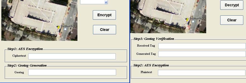
39 It s s also about place Geo-encryption encryption Something New Who can receive the encrypted file? Conventional Cryptographic Algorithms Who has the random key? Geo-encryption and Signal Authentication Who has the navigational receiver & can locate at the right location 3400 m 2 /153,295,000 km 2 = 2.2 x
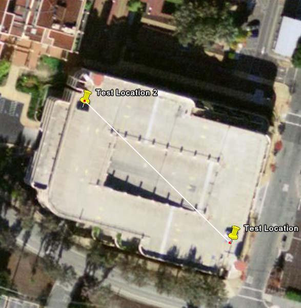


40 Data Collection Underway m 40
41 Loran from an International Perspective It s s not your grandparent s (or your parent s) Loran! 41
42 Loran from an International Perspective Enhanced Loran (eloran) Definition Document published by the International Loran Association to provide a high-level definition of eloran for policy makers, service providers, and users. Developed in November 2006 at the United States Coast Guard Navigation Center by an international team of authors. States that eloran is an internationally-standardized positioning, navigation, and timing (PNT) service for use by many modes of transport and in other applications that takes full advantage of 21 st century technology. meets the accuracy, availability, integrity, and continuity performance requirements for aviation non-precision instrument approaches, maritime harbor entrance and approach maneuvers, land-mobile vehicle navigation, and location-based services, and is a precise source of time and frequency for applications such as telecommunications. allows GNSS users to retain the safety, security, and economic benefits of GNSS, even when their satellite services are disrupted. Loran OIC Conference Sonoma, California 11 September
43 What s s Next? My Crystal Ball Decision on eloran!!! Completion of Modernization at St. Paul Installation of commercial power at Shoal Cove Initial Operational Capability (IOC) of eloran precise time in CONUS Proliferation of eloran Time as primary reference system alternative Commencement of RTCM work on eloran standards for Maritime Commencement of RTCA work on eloran standards for Aviation Testing/acceptance of prototype unmanned eloran transmitting facility IOC of Harbor Entrance and Approach at selected locations in CONUS Certification of eloran avionics/ IOC of Non-Precision Approach at selected locations in CONUS Completion of eloran modernization in Alaska Use of second (10 th Pulse) eloran data channel for reduced WAAS message broadcasts (as a result of L5 availability) Final Operational Capability (IOC) of eloran precise time in CONUS/GPSindependent synchronization of eloran clock 43

44 Far and away the best prize that life offers is the chance to work hard at work worth doing. -- Theodore Roosevelt 44
45 A Heartfelt Thank You to All! 1. The migration from a Loran-C C radionavigation system to enhanced Loran (eloran) has been and is key to the system s s continuation. 2. If it were not for the work of those in attendance here today and the work of many, many more dedicated people who could not be here, the Loran system in the United States, and perhaps the world, would have ceased to exist in the 21 st Century. 3. We re not there yet, there s s still much to do, but every team needs to celebrate its achievements this team has much to celebrate -- and much to be thankful for! 45
46 Summary The Future is Bright! Modernization efforts are continuing St. Paul, Alaska Loran Station modernization ongoing Airport and Harbor surveys to support NPA/HEA operations ongoing GPS-Independent UTC Synchronization work ongoing Navigation and Time receiver development ongoing eloran Decision in process Awaiting announcement by SecDOT and SecDHS this year! (really!) 46

47 Questions 47
48 Timing accuracy model Description & Comments Non-differential (slide 2) Accuracy is rss sum of: 30 ns for combination of receiver bias & transmitter accuracy A noise term with noise at the 95% level, 10dB credit for clipping and 20 second averaging A term based on map of seasonal variations in propagation Because seasonal variations dominate in the rss sum, and western US has smaller seasonal variations, model shows better accuracy in west Differential Differential Accuracy is rss sum of: 30 ns for combination of receiver bias & base station error Same noise term as above A term proportional to distance from closest base station (currently 0.5 ns/nm) Overall accuracy (in slide 3) is the minimum of the two accuracies above Slide 4 shows which is minimum, except for NE US, differential corrections do not help timing users, because navigation (HEA) users need to use much more distant stations, they still need differential corrections in the west Current model suggest need for either station or monitor in Iowa/Nebraska Previous studies had suggested transmitter in this area would considerably enhance RNP availability. 48
49 Improvements Needed to Achieve eloran Capability Aviation - NPA Implementation of Loran Data Channel (LDC) via 9 th -pulse communications to broadcast: Station ID Integrity Message Early Skywave warning Improved monitor system to detect skywave and out of tolerance condition Time of Transmission (TOT) Control ASF value(s) for each airport Certified avionics (eloran/multimode) to allow use of existing RNP 0.3 approach and landing procedures 49
50 Improvements Needed to Achieve eloran Capability Maritime - HEA Implementation of Loran Data Channel (LDC) via 9 th -pulse communications to broadcast: Station ID Integrity Message Differential Loran Information Improved and expanded monitor system to provide real-time differential corrections to support 8m-20m accuracy requirement Time of Transmission (TOT) Control Harbor surveys to establish ASF grid Maritime receivers (eloran/multimode) to provide required accuracy 50
51 Improvements Needed to Achieve eloran Capability Time Implementation of Loran Data Channel (LDC) via 9 th - pulse communications to broadcast: Differential Loran Information Improved and expanded monitor system to support precise time (<50ns) Time of Transmission (TOT) Control eloran Time receivers to provide required accuracy Frequency Nothing We re already Stratum 1! (1 x ) 51


52 GPS/WAAS/eLoran Receivers for Aviation Phase I Phase II 52


53 Example Aviation Tests: Rockwell/ Locus Integration of GPS-IMU IMU-Loran GPS-Loran Antenna inside radome AHC-3000A AHRS modified to add IMU outputs 53


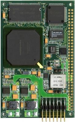
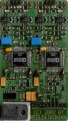
54 GPS/WAAS/eLoran Receivers for Maritime Signal Processor 77 x 51 mm Front End & ADC 77 x 47 mm GPS WAAS mm mm 30 mm 54
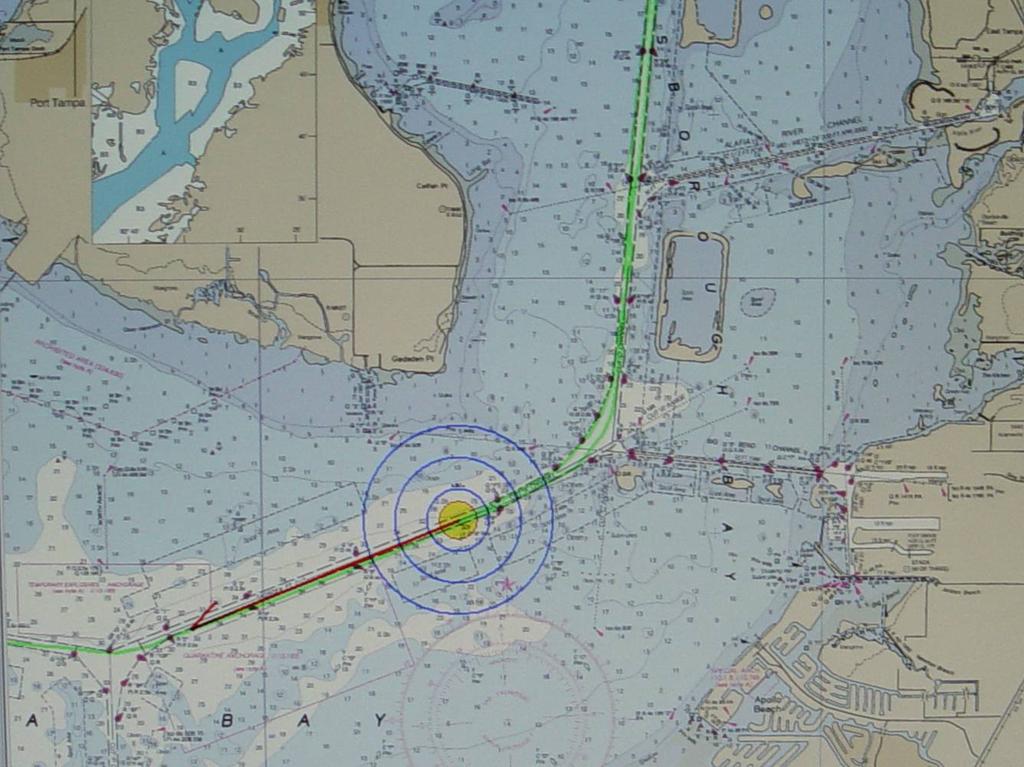


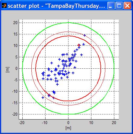

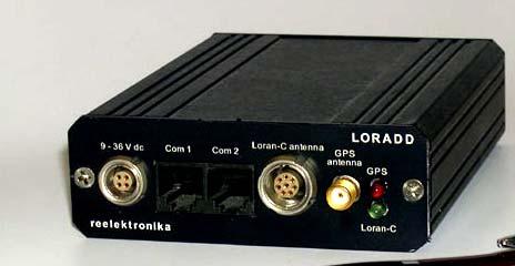
55 Tampa Bay Measurements Megapulse/Reelektronika Receiver April mm (4.33 in) 85 mm (3.35 in) 30 mm (1.18 in) 55
Wide Area Time distribution Via eloran. NASPI WG Meeting
 Wide Area Time distribution Via eloran NASPI WG Meeting March 22 2017 This work is supported through a Cooperative Research and Development Agreement (CRADA) with the Department of Homeland Security (DHS)
Independent Assessment Team (IAT) Summary of Initial Findings on eloran
 Summary of Initial Findings on eloran") I N ST I T U T E F O R D E F E N SE A N A L Y S E S Independent Assessment Team (IAT) Summary of Initial Findings on eloran Dr. Bradford Parkinson, Chair James Doherty, Executive Director John Darrah Arnold
I N ST I T U T E F O R D E F E N SE A N A L Y S E S Independent Assessment Team (IAT) Summary of Initial Findings on eloran Dr. Bradford Parkinson, Chair James Doherty, Executive Director John Darrah Arnold
Providing a Resilient Timing and UTC Service Using eloran in the United States. Charles Schue - ION PTTI Monterey, CA
 Providing a Resilient Timing and UTC Service Using eloran in the United States Charles Schue - ION PTTI Monterey, CA January 27, 2016 Motivation For a Resilient Timing and UTC Service GPS/GNSS Vulnerabilities
PROGRAM MANAGER S NOTE
 Loran s Capability to Mitigate the Impact of a GPS Outage on GPS Position, Navigation, and Time Applications Prepared for the FEDERAL AVIATION ADMINISTRATION VICE PRESIDENT FOR TECHNICAL OPERATIONS NAVIGATION
Implementing a Wide Area High Accuracy UTC Service via eloran
 Implementing a Wide Area High Accuracy UTC Service via eloran ION PTTI, Boston, MA December 3, 2014 Dr. Gerard Offermans Overview Basis for consideration of eloran as a source of precise time, frequency,
Protection Augmentation Toughness and Alternatives of GNSS. Melaha 2016 Concord Al-Salam Hotel Cairo, April 25,2016 Refaat Rashad
 Protection Augmentation Toughness and Alternatives of GNSS Melaha 2016 Concord Al-Salam Hotel Cairo, April 25,2016 Refaat Rashad Road Map of the Presentation 1- How Good are GNSS 2- How Vulnerable are
Modernized LORAN-C Timing Test Bed Status and Results
 Modernized LORAN-C Timing Test Bed Status and Results Tom Celano and Casey Biggs Timing Solutions Corporation 4775 Walnut St Boulder, CO tpcelano@timing.com Benjamin Peterson Peterson Integrated Positioning
Timing via the New LORAN-C System W H I T E PA P E R
 Timing via the New LORAN-C System WHITE PAPER Timing via the New LORAN-C System LT Kevin Carroll, USCG Loran Support Unit Tom Celano, Symmetricom Abstract In 1999, the United States Federal Radionavigation
Results from a GPS Timing Criticality Assessment
 Results from a GPS Timing Criticality Assessment European Navigation Conference, GNSS 2008 Session 2b - Timing James Carroll, DOT/RITA Volpe Center April 2008 Introduction Timing Criticality Assessment
Note that MIFD II will also be influencing standards in the US.
 1 2 Why should the Financial Sector care? Note that MIFD II will also be influencing standards in the US. The best contingency solutions is one that includes a Resilience Triad : GPS/GNSS, eloran, and
Nigerian Communications Satellite Ltd. (NIGCOMSAT)
") OVERVIEW OF NIGERIAN SATELLITE AUGMENTATION SYSTEM COMMENCING WITH PILOT DEMONSTRATION TO VALIDATE NATIONAL WORK PLAN presented by Dr. Lawal Lasisi Salami, NIGERIAN COMMUNICATIONS SATELLITE LTD UNDER FEDERAL
OVERVIEW OF NIGERIAN SATELLITE AUGMENTATION SYSTEM COMMENCING WITH PILOT DEMONSTRATION TO VALIDATE NATIONAL WORK PLAN presented by Dr. Lawal Lasisi Salami, NIGERIAN COMMUNICATIONS SATELLITE LTD UNDER FEDERAL
Resilience through co-primary PNT solutions: GPS and eloran. By Charles Schue September 4, 2014
 1 Resilience through co-primary PNT solutions: GPS and eloran By Charles Schue September 4, 2014 Outline The Problem: Vulnerabilities The Need: Resilience The Solution: Co-Primary GPS and eloran eloran
Enhanced Loran. Sherman Lo, Benjamin Peterson With contributions from the FAA Loran Evaluation Team
 Enhanced Loran Sherman Lo, Benjamin Peterson With contributions from the FAA Loran Evaluation Team Acknowledgments & Disclaimer The presenters gratefully acknowledge the Federal Aviation Administration
GPS/WAAS Program Update
 GPS/WAAS Program Update UN/Argentina Workshop on the Applications of GNSS 19-23 March 2018 Cordoba, Argentina GNSS: A Global Navigation Satellite System of Systems Global Constellations GPS (24+3) GLONASS
Modernized LORAN-C Timing Test Bed Status and Results
 Modernized LORAN-C Timing Test Bed Status and Results Tom Celano and Casey Biggs Timing Solutions Corporation 4775 Walnut St Boulder, CO tpcelano@timing.com Benjamin Peterson Peterson Integrated Positioning
Canadian Coast Guard Review to Implement a Resilient Position, Navigation and Timing Solution for Canada. Mariners Workshop January 31 st, 2018
 Canadian Coast Guard Review to Implement a Resilient Position, Navigation and Timing Solution for Canada Mariners Workshop January 31 st, 2018 Outline Overview of GNSS use in the marine sector CCG Activities
IMPLEMENTATION OF GNSS BASED SERVICES
 International Civil Aviation Organization IMPLEMENTATION OF GNSS BASED SERVICES Julio Siu Communications, Navigation and Surveillance Regional Officer ICAO NACC Regional Office ICAO Workshop on PBN Airspace
Improving Loran Coverage with Low Power Transmitters
 Improving Loran Coverage with Low Power Transmitters Benjamin B. Peterson, Peterson Integrated Geopositioning Sherman C. Lo, Stanford University Tim Hardy, Nautel Per K. Enge, Stanford University BIOGRAPHY
eloran Points of Light
 There is considerable misinformation, outdated information, and obviously misleading information being promulgated as fact about Enhanced Loran (eloran). This Points of Light paper is intended to respond
Benefit-Cost Assessment Of The Use Of LORAN To Mitigate GPS Vulnerability For Positioning, Navigation, And Timing Services.
 Benefit-Cost Assessment Of The Use Of LORAN To Mitigate GPS Vulnerability For Positioning, Navigation, And Timing Services Final Report March 30, 2004 Prepared for Office of the Under Secretary for Transportation
A Holistic Approach to Trusted, Resilient PNT: GNSS, STL and eloran
 A Holistic Approach to Trusted, Resilient PNT: GNSS, STL and eloran John Fischer, Vice President of Research & Development, Orolia Dr. Michael O Connor, CEO, Satelles Charles Schue, CEO, UrsaNav With an
Wide Area Augmentation System (WAAS)
") Wide Area Augmentation System (WAAS) Ionospheric Effects Symposium By: Jason Burns Technology Evolution Lead Date: Agenda WAAS Overview Ionospheric Effects on WAAS Future Plans User Segment Update 2 WAAS
Wide Area Augmentation System (WAAS) Ionospheric Effects Symposium By: Jason Burns Technology Evolution Lead Date: Agenda WAAS Overview Ionospheric Effects on WAAS Future Plans User Segment Update 2 WAAS
S a t e l l i t e T i m e a n d L o c a t i o n. N o v e m b e r John Fischer VP Advanced R&D
 STL - S a t e l l i t e T i m e a n d L o c a t i o n N o v e m b e r 2 0 1 7 John Fischer VP Advanced R&D jfischer@orolia.com 11/28/201 1 7 WHY AUGMENT GNSS? Recent UK Study Economic Input to UK of a
Loran Coverage Availability Simulation Tool
 Loran Coverage Availability Simulation Tool Sherman C. Lo, Stanford University Benjamin B. Peterson, Peterson Integrated Geopositioning C. O. Lee Boyce Jr., Stanford University Per K. Enge, Stanford University
eloran Points of Light
 There is considerable misinformation, outdated information, and obviously misleading information being promulgated as fact about Enhanced Loran (eloran). This Points of Light paper is intended to respond
Alternative Positioning, Navigation & Timing (APNT) Study Update
 Study Update") Alternative Positioning, Navigation & Timing (APNT) Study Update Why APNT? The transformation of the National Airspace System (NAS) to the Next Generation Air Transportation System (NextGen) relies on
Alternative Positioning, Navigation & Timing (APNT) Study Update Why APNT? The transformation of the National Airspace System (NAS) to the Next Generation Air Transportation System (NextGen) relies on
PTTI CAPABILITIES OF THE MODERNIZED LORAN SYSTEM
 PTTI CAPABILITIES OF THE MODERNIZED LORAN SYSTEM Kirk Montgomery Symmetricom, Inc. kmontgomery@symmetricom.com Michael A. Lombardi Time and Frequency Division National Institute of Standards and Technology
SATELLITE BASED AUGMENTATION SYSTEM (SBAS) FOR AUSTRALIA
 FOR AUSTRALIA") SATELLITE BASED AUGMENTATION SYSTEM (SBAS) FOR AUSTRALIA AN AIN POSITION PAPER SUBMITTED TO VARIOUS GOVERNMENT DEPARTMENTS BY MR KYM OSLEY AM, CSC, EXEC SECRETARY AIN What are GNSS Augmentation Systems?
SATELLITE BASED AUGMENTATION SYSTEM (SBAS) FOR AUSTRALIA AN AIN POSITION PAPER SUBMITTED TO VARIOUS GOVERNMENT DEPARTMENTS BY MR KYM OSLEY AM, CSC, EXEC SECRETARY AIN What are GNSS Augmentation Systems?
Three Wishes. and an elaboration. For Reception of. Professor Bradford Parkinson Stanford University. (these are my personal views)
") Three Wishes and an elaboration For Reception of Professor Bradford Parkinson Stanford University (these are my personal views) Three Wishes - Dr, Parkinson 2017 1 Good News: World-wide dependency on GNSS
Three Wishes and an elaboration For Reception of Professor Bradford Parkinson Stanford University (these are my personal views) Three Wishes - Dr, Parkinson 2017 1 Good News: World-wide dependency on GNSS
Civil GPS Service Interface Committee (CGSIC) International Committee on GNSS November 2016
 International Committee on GNSS November 2016") Civil GPS Service Interface Committee (CGSIC) International Committee on GNSS 06-11 November 2016 Russell Holmes CGSIC Deputy Chair U.S. Coast Guard Navigation Center 30 th Anniversary of the CGSIC CGSIC
Civil GPS Service Interface Committee (CGSIC) International Committee on GNSS 06-11 November 2016 Russell Holmes CGSIC Deputy Chair U.S. Coast Guard Navigation Center 30 th Anniversary of the CGSIC CGSIC
GPS Interference Detection & Mitigation
 GPS Interference Detection & Mitigation GAARDIAN GNSS AVAILABILITY ACCURACY RELIABILITY and INTEGRITY ASSESSMENT for TIMING and NAVIGATION A Technology Strategy Board funded collaboration Charles Curry,
The Effect of Radio Frequency Interference on GNSS Signals and Mitigation Techniques Presented by Dr. Tarek Attia
 International Conference and Exhibition Melaha2016 GNSS WAY Ahead 25-27 April2016, Cairo, Egypt The Effect of Radio Frequency Interference on GNSS Signals and Mitigation Techniques Presented by Dr. Tarek
Global Positioning Systems Directorate
 Space and Missile Systems Center Global Positioning Systems Directorate GPS Program Update to 8 th Stanford PNT Symposium 30 Oct 2014 Col Matt Smitham Deputy Director, GPS Directorate Global Positioning
Radio Navigation Aids Flight Test Seminar
 Radio Navigation Aids Flight Test Seminar FLIGHT INSPECTION IN THE NEW MILLENNIUM Curt Keedy FAA Flight Inspection Policy and Standards Change, Challenge, and Opportunity CHANGES Global Positioning system
Defining Primary, Secondary, Additional Secondary Factors for RTCM Minimum Performance Specifications (MPS)
") Defining Primary, Secondary, Additional Secondary Factors for RTCM Minimum Performance Specifications (MPS) Sherman Lo, Stanford University, Michael Leathem, Cross Rate Technologies, Gerard Offermans,
Defining Primary, Secondary, Additional Secondary Factors for RTCM Minimum Performance Specifications (MPS) Sherman Lo, Stanford University, Michael Leathem, Cross Rate Technologies, Gerard Offermans,
On Location at Stanford University
 Thank you for inviting me to Calgary On Location at Stanford University by Per Enge (with the help of many) May 29, 2009 With Gratitude to the Federal Aviation Administration from Misra and Enge, 2006
U.S. Perspectives on eloran as a Timing Backup And Available Hardware. Charles Schue UrsaNav, Inc. KTN Trinity House October 8, 2012
 U.S. Perspectives on eloran as a Timing Backup And Available Hardware Charles Schue UrsaNav, Inc. KTN Trinity House October 8, 2012 Corporate Overview Chesapeake, Virginia, USA Founded in 2004 Four main
GBAS FOR ATCO. June 2017
 GBAS FOR ATCO June 2017 Disclaimer This presentation is for information purposes only. It should not be relied on as the sole source of information, and should always be used in the context of other authoritative
Providing a Resilient Timing and UTC Service Using eloran in the United States
 Providing a Resilient Timing and UTC Service Using eloran in the United States Gerard Offermans, Steve Bartlett, Charles Schue, UrsaNav, Inc. BIOGRAPHIES Dr. Gerard Offermans is Senior Research Scientist
Geoscience & Positioning, Navigation and Timing Services for Canadians
 Geoscience & Positioning, Navigation and Timing Services for Canadians Calvin Klatt, Ph.D. Director and Chief Geodesist Natural Resources Canada / Directeur et géodésien principal Ressources naturelles
GA and NextGen How technologies like WAAS and ADS-B will change your flying! Presented By Claire Kultgen
 GA and NextGen How technologies like WAAS and ADS-B will change your flying! Presented By Claire Kultgen Overview 1. TIS 2. ADS-B FIS-B TIS-B ADS-R 3. WAAS 4. T-Routes and GPS MEAs Questions Chat Pilot
CAN LORAN MEET GPS BACKUP REQUIREMENTS?
 To be presented at the 11 th Saint Petersburg International Conference on Integrated Navigation Systems, 24 26 May 24 CAN LORAN MEET GPS BACKUP REQUIREMENTS? Gregory Johnson, MSEE, Ruslan Shalaev, BSCS
Black Swans, White Elephants and Delivering a New National Timescale with eloran
 Black Swans, White Elephants and Delivering a New National Timescale with eloran Charles Curry BEng, CEng, FIET Managing Director Chronos Technology Ltd SFR, Paris 18 th July 2014 PNT First Experiences
Early Skywave Detection Network: Preliminary Design and Analysis
 Early Skywave Detection Network: Preliminary Design and Analysis Sherman Lo, Stanford University, Peter Morris, Raytheon, Per Enge, Stanford University, A skywave signal is one has propagated by reflecting
White Paper. GPS Backup For Position, Navigation and Timing. Transition Strategy for Navigation and Surveillance
 White Paper GPS Backup For Position, Navigation and Timing Transition Strategy for Navigation and Surveillance August 22, 2006 By Dr. Robert Lilley Gary Church Michael Harrison Aviation Management Associates,
Global Navigation Satellite System (GNSS) GPS Serves Over 400 Million Users Today. GPS is used throughout our society
 GPS Serves Over 400 Million Users Today. GPS is used throughout our society") Global avigation Satellite System (GSS) For freshmen at CKU AA December 10th, 2009 by Shau-Shiun Jan ICA & IAA, CKU Global avigation Satellite System (GSS) GSS (Global Positioning System, GPS) Basics Today
Global avigation Satellite System (GSS) For freshmen at CKU AA December 10th, 2009 by Shau-Shiun Jan ICA & IAA, CKU Global avigation Satellite System (GSS) GSS (Global Positioning System, GPS) Basics Today
PRELIMINARY PROGRAMME
 ICG EXPERTS MEETING: GLOBAL NAVIGATION SATELLITE SYSTEMS SERVICES 14-18 December 2015 Vienna International Centre, Vienna, Austria Organized by International Committee on Global Navigation Satellite Systems
Understanding and Mitigating Global Positioning System (GPS) Vulnerabilities
 Vulnerabilities") Understanding and Mitigating Global Positioning System (GPS) Vulnerabilities Issue: Increasing US military dependence on GPS may lead to a single point of failure if vulnerabilities are not understood
Understanding and Mitigating Global Positioning System (GPS) Vulnerabilities Issue: Increasing US military dependence on GPS may lead to a single point of failure if vulnerabilities are not understood
On Location at Stanford University
 Thank you for inviting me (back) to Deutsches Zentrum für Luft- und Raumfahrt On Location at Stanford University by Per Enge (with the help of many) July 27, 2009 My thanks to the Federal Aviation Administration
Proceedings of Al-Azhar Engineering 7 th International Conference Cairo, April 7-10, 2003.
 Proceedings of Al-Azhar Engineering 7 th International Conference Cairo, April 7-10, 2003. MODERNIZATION PLAN OF GPS IN 21 st CENTURY AND ITS IMPACTS ON SURVEYING APPLICATIONS G. M. Dawod Survey Research
Introduction to the Global Positioning System
 GPS for Fire Management - 2004 Introduction to the Global Positioning System Pre-Work Pre-Work Objectives Describe at least three sources of GPS signal error, and identify ways to mitigate or reduce those
ICAO policy on GNSS, GNSS SARPs and global GNSS developments. Jim Nagle Chief, Communication, Navigation and Surveillance Section ICAO
 ICAO policy on GNSS, GNSS SARPs and global GNSS developments Jim Nagle Chief, Communication, Navigation and Surveillance Section ICAO Presentation overview Introduction GNSS developments in ICAO ICAO policy
The Global Positioning System
 The Global Positioning System 5-1 US GPS Facts of Note DoD navigation system First launch on 22 Feb 1978, fully operational in 1994 ~$15 billion (?) invested to date 24 (+/-) Earth-orbiting satellites
GPS Milestones, cont. GPS Milestones. The Global Positioning Sytem, Part 1 10/10/2017. M. Helper, GEO 327G/386G, UT Austin 1. US GPS Facts of Note
 The Global Positioning System US GPS Facts of Note DoD navigation system First launch on 22 Feb 1978, fully operational in 1994 ~$15 billion (?) invested to date 24 (+/-) Earth-orbiting satellites (SVs)
Leadership in Resilient PNT
 www.ursanav.com www.nautelnav.com 29 November 2017 Leadership in Resilient PNT The Need for Resilient PNT Position, Navigation, and Timing, or PNT, is known as the hidden utility. Despite its widespread
Space and Missile Systems Center
 Space and Missile Systems Center Global Positioning Systems Directorate GPS Status & Modernization Progress: Service, Satellites, Control Segment, and Military GPS User Equipment 3 Nov 2016 Col Steve Whitney,
Communications Sector. Use of Positioning, Navigation and Timing (PNT) Services
 Services") Communications Sector Use of Positioning, Navigation and Timing (PNT) Services These comments are based upon public and private assertions made by representatives of this Critical Infrastructure/Key Resource
Communications Sector Use of Positioning, Navigation and Timing (PNT) Services These comments are based upon public and private assertions made by representatives of this Critical Infrastructure/Key Resource
The Politics of Resilience Speaking Truth to Power the Last 18 Months
 The Politics of Resilience Speaking Truth to Power the Last 18 Months APRIL 2017 Workshop On Synchronization & Timing a single point of failure December 2015 US increasingly at risk from disruption 2011
2010 FEDERAL RADIONAVIGATION PLAN
 2010 FEDERAL RADIONAVIGATION PLAN Published by Department of Defense, Department of Homeland Security, and Department of Transportation This document is available to the public through the National Technical
Lecture-1 CHAPTER 2 INTRODUCTION TO GPS
 Lecture-1 CHAPTER 2 INTRODUCTION TO GPS 2.1 History of GPS GPS is a global navigation satellite system (GNSS). It is the commonly used acronym of NAVSTAR (NAVigation System with Time And Ranging) GPS (Global
Information Technology Sector. Use of Positioning, Navigation and Timing (PNT) Services
 Services") Information Technology Sector Use of Positioning, Navigation and Timing (PNT) Services These comments are based upon public and private assertions made by representatives of this Critical Infrastructure/Key
Information Technology Sector Use of Positioning, Navigation and Timing (PNT) Services These comments are based upon public and private assertions made by representatives of this Critical Infrastructure/Key
On the Uses of High Accuracy eloran Time, Frequency, and Phase
 On the Uses of High Accuracy eloran Time, Frequency, and Phase RIN INC, Manchester, England February 25, 2015 Charles Schue President & CEO UrsaNav, Inc. Overview The Problem: We need time all the time!
Introduction to the Global Positioning System
 GPS for ICS - 2003 Introduction to the Global Positioning System Pre-Work Pre-Work Objectives Describe at least three sources of GPS signal error, and ways to mitigate or reduce those errors. Identify
Alternate Position, Navigation & Time APNT for Civil Aviation
 Alternate Position, Navigation & Time APNT for Civil Aviation For Working Group B of the International GNSS Committee Shanghai, May 2011 by Per Enge & Leo Eldredge Work supported by the Federal Aviation
The Indian Regional Navigation. First Position Fix with IRNSS. Successful Proof-of-Concept Demonstration
 Successful Proof-of-Concept Demonstration First Position Fix with IRNSS A. S. GANESHAN, S. C. RATNAKARA, NIRMALA SRINIVASAN, BABU RAJARAM, NEETHA TIRMAL, KARTIK ANBALAGAN INDIAN SPACE RESEARCH ORGANISATION
CLICK HERE TO KNOW MORE
 CLICK HERE TO KNOW MORE Should GNSS Become a National Critical Infrastructure? Ooi Wei Han, Noordin Ahmad, Shahrizal IM National Space Agency (ANGKASA) Ministry of Science, Technology and Innovation (MOSTI)
THE TIME DISTRIBUTION SYSTEM FOR THE WIDE AREA AUGMENTATION SYSTEM (WAAS)
") 30th Annual Precise Time and Time Interval (PTTI, Meeting THE TIME DISTRIBUTION SYSTEM FOR THE WIDE AREA AUGMENTATION SYSTEM (WAAS) William J. Klepczynski Innovative Solutions International, Inc. 1608
30th Annual Precise Time and Time Interval (PTTI, Meeting THE TIME DISTRIBUTION SYSTEM FOR THE WIDE AREA AUGMENTATION SYSTEM (WAAS) William J. Klepczynski Innovative Solutions International, Inc. 1608
Differential Loran-C
 Differential Loran-C Kevin M. Carroll and Anthony Hawes, U. S. Coast Guard Loran Support Unit Benjamin Peterson and Kenneth Dykstra, Peterson Integrated Geopositioning, LLC Peter Swaszek, University of
Airport ASF Mapping Methodology Update
 Airport ASF Mapping Methodology Update Peter F. Swaszek, University of Rhode Island Gregory Johnson, Mark Wiggins, Michael Kuhn, Alion Science & Technology Richard Hartnett, US Coast Guard Academy Kevin
GNSS: CNS Dependencies
 GNSS: CNS Dependencies Lendina Smaja DATM/RDS/NAV 10 March 2015 Agenda The Future Technical Environment GNSS GNSS Supporting CNS Loss of Signal Impact GNSS: CNS Dependencies 2 Original FANS CNS/ATM Concept
Alternative Positioning, Navigation, Timing, and Data for Korea and the World
 Shared interest in a more productive tomorrow. Alternative Positioning, Navigation, Timing, and Data for Korea and the World Prepared by: Mr. Charles Schue, President & CEO ILA40 / KIN November 17, 2011
GLObal Navigation Satellite System (GLONASS)
") FEDERAL SPACE AGENCY GLObal Navigation Satellite System (GLONASS) Sergey Revnivykh Deputy Director General Central Research Institute of Machine Building Head of PNT Center 4-th meeting of International
FEDERAL SPACE AGENCY GLObal Navigation Satellite System (GLONASS) Sergey Revnivykh Deputy Director General Central Research Institute of Machine Building Head of PNT Center 4-th meeting of International
COMMUNICATIONS FOR MARITIME SAFETY AND EFFICIENCY. Francis Zachariae, Secretary-General, IALA
 COMMUNICATIONS FOR MARITIME SAFETY AND EFFICIENCY Francis Zachariae, Secretary-General, IALA IALA and its Purpose Non profit, international technical association established in 1957 Two Goals aimed at
GPS Modernization and Program Update
 GPS Modernization and Program Update GPS Update to ION Southern California Chapter 22 Feb 2011 Colonel Bernie Gruber Director Global Positioning Systems Directorate Contents Current Constellation Modernization
GNSS VULNERABILITY AND CRITICAL INFRASTRUCTURE
 GNSS VULNERABILITY AND CRITICAL INFRASTRUCTURE NNF CONFERENCE 24 MAY 2012 Brynjar Hansen Senior adviser Norwegian Space Centre Lars Giske Senior adviser Norwegian Space Centre MULTI GNSS EXTERNAL COOPERATION
DEFINING THE FUTURE OF SATELLITE SURVEYING WITH TRIMBLE R-TRACK TECHNOLOGY
 DEFINING THE FUTURE OF SATELLITE SURVEYING WITH TRIMBLE R-TRACK TECHNOLOGY EDMOND NORSE, GNSS PORTFOLIO MANAGER, TRIMBLE SURVEY DIVISION WESTMINSTER, CO USA ABSTRACT In September 2003 Trimble introduced
The International Scene: How Precise Positioning Will Underpin Critical GNSS Applications
 The International Scene: How Precise Positioning Will Underpin Critical GNSS Applications School of Civil & Environmental Engineering, UNSW, Sydney, Australia Chris Rizos Member of the IGS Governing Board
02 Issue. e-navigation News. GNSS Vulnerability. Dublin Bay Digital Diamond. e-navigation. Demonstrator Update International. e-navigation.
 CORPORATE SECURITY TEAMWORK EVENTS 02 Issue e-navigation News GNSS Vulnerability Dublin Bay Digital Diamond e-navigation Demonstrator Update International e-navigation update June 2014 www.cil.ie +353
Report of Working Group B: Enhancement of Global Navigation Satellite Systems Services Performance
 Report of : Enhancement of Global Navigation Satellite Systems Services Performance 1. The Working Group on Enhancement of Global Navigation Satellite Systems (GNSS) Service Performance (WG-B) of the International
EGNOS status and performance in the context of marine navigation requirements
 EGNOS status and performance in the context of marine navigation requirements J. Cydejko Gdynia Maritime University, Gdynia, Poland ABSTRACT: The current status of EGNOS (December 2006) is described as
What s up with WAAS?
 I N D U S T RY What s up with WAAS? There s a bright new star in the GPS constellation and pretty soon every bright pilot is going to want to use it. B Y D A L E S M I T H You probably didn t notice it
Challenges and Methods for Integrity Assurance in Future GNSS
 Challenges and Methods for Integrity Assurance in Future GNSS Igor Mozharov Division Head, Information and Analytical Center for PNT, Central Research Institute for Machine Building, Roscosmos igor.mozharov@mcc.rsa.ru
Update from the United States Space-Based Positioning, Navigation, and Timing Advisory Board
 Update from the United States Space-Based Positioning, Navigation, and Timing Advisory Board John W. Betz, PhD PNTAB Member Presented to ICG-12, Kyoto, Japan December 2017 Approved for Public Release;
Near Term Improvements to WAAS Availability
 Near Term Improvements to WAAS Availability Juan Blanch, Todd Walter, R. Eric Phelts, Per Enge Stanford University ABSTRACT Since 2003, when it was first declared operational, the Wide Area Augmentation
PROTECTING GPS/GNSS-RELIANT MILITARY SYSTEMS
 PROTECTING GPS/GNSS-RELIANT MILITARY SYSTEMS John Fischer VP Advanced R&D Jon Sinden Product Manager, Rugged PNT 6/21/2018 ABOUT OROLIA A world leader in assured positioning, navigation and timing (PNT)
EGNOS/EDAS based solution for the French DGPS network. Author: Etienne LEROY
 EGNOS/EDAS based solution for the French DGPS network. Author: Etienne LEROY Date 04/10/2017 1.Context 2.EDAS Centralized based architecture 3.Software and devices 4.Test Campaign 5.Cost based analysis
Jager UAVs to Locate GPS Interference
 JIFX 16-1 2-6 November 2015 Camp Roberts, CA Jager UAVs to Locate GPS Interference Stanford GPS Research Laboratory and the Stanford Intelligent Systems Lab Principal Investigator: Sherman Lo, PhD Area
Satellite-Based Augmentation System (SBAS) Integrity Services
 Integrity Services") Satellite-Based Augmentation System (SBAS) Integrity Services Presented To: Munich, Germany Date: March 8, 2010 By: Leo Eldredge, Manager GNSS Group, FAA FAA Satellite Navigation Program 2 Wide Area Augmentation
Satellite-Based Augmentation System (SBAS) Integrity Services Presented To: Munich, Germany Date: March 8, 2010 By: Leo Eldredge, Manager GNSS Group, FAA FAA Satellite Navigation Program 2 Wide Area Augmentation
Modern ARINC 743B DO-229D and DO-253C GLSSU Solutions For Retrofit
 Commercial Aviation Modern ARINC 743B DO-229D and DO-253C GLSSU Solutions For Retrofit Presented to AEEC March 2010 The Classic Retrofit Challenge Financial: Operating budget year financing ROI payback:
ACCURACY AND AVAILABILITY OF EGNOS - RESULTS OF OBSERVATIONS
 ARTIFICIAL SATELLITES, Vol. 46, No. 3 2011 DOI: 10.2478/v10018-012-0003-0 ACCURACY AND AVAILABILITY OF EGNOS - RESULTS OF OBSERVATIONS Andrzej Felski, Aleksander Nowak Polish Naval Academy, a.felski@amw.gdynia.pl
RESOLUTION MSC.401(95) (Adopted on 8 June 2015) PERFORMANCE STANDARDS FOR MULTI-SYSTEM SHIPBORNE RADIONAVIGATION RECEIVERS
 (Adopted on 8 June 2015) PERFORMANCE STANDARDS FOR MULTI-SYSTEM SHIPBORNE RADIONAVIGATION RECEIVERS") ANNEX 17 MSC 95/22/Add.2 Annex 17, page 1 THE MARITIME SAFETY COMMITTEE, RECALLING Article 28(b) of the Convention on the International Maritime Organization concerning the functions of the Committee,
ANNEX 17 MSC 95/22/Add.2 Annex 17, page 1 THE MARITIME SAFETY COMMITTEE, RECALLING Article 28(b) of the Convention on the International Maritime Organization concerning the functions of the Committee,
Horizontal Advanced RAIM: Operational Benefits and Future Challenges
 Horizontal Advanced RAIM: Operational Benefits and Future Challenges International Technical Symposium on Navigation and Timing 2015 Session Air Navigation November 2015 Toulouse/France 1 ICAO ABAS augmentation
School of Civil & Environmental Engineering, UNSW, Sydney, Australia. Chris Rizos. President Australian Institute of Navigation
 The Threat to Space Based Service (for PNT applications) School of Civil & Environmental Engineering, UNSW, Sydney, Australia Chris Rizos President Australian Institute of Navigation Outline GNSS... a
The Wide Area Augmentation System
 The Wide Area Augmentation System Stanford University http://waas.stanford.edu What is Augmentation? 2 Add to GNSS to Enhance Service Improve integrity via real time monitoring Improve availability and
Understanding GPS: Principles and Applications Second Edition
 Understanding GPS: Principles and Applications Second Edition Elliott Kaplan and Christopher Hegarty ISBN 1-58053-894-0 Approx. 680 pages Navtech Part #1024 This thoroughly updated second edition of an
GNSS Programme. Overview and Status in Europe
 GNSS Programme Overview and Status in Europe Inaugural Forum Satellite Positioning Research and Application Center 23 April 2007 Tokyo Presented by Thomas Naecke (European Commission) Prepared by Daniel
Arctic Navigation Issues. e-nav conference Nordic Institute of Navigation Bergen, March 5 th 2009
 Arctic Navigation Issues e-nav conference Nordic Institute of Navigation Bergen, March 5 th 2009 by Anna B.O. Jensen - AJ Geomatics Jean-Paul Sicard - Rovsing A/S March 2009 1 Outline Reduction of ice
AEEC 2013 Presentation to the Airlines and the Aviation Industry
 AEEC 2013 Presentation to the Airlines and the Aviation Industry Multi-Frequency/Multi-Constellation (MFMC) GNSS Receivers Value for Aviation and Airlines John Studenny CMC GPS Product Manager Alain Beaulieu
Federal Radionavigation Plan
 Federal Radionavigation Plan 1999 NOTICE The United States Government does not endorse products or manufacturers. Trade or manufacturers names appear herein solely because they are considered essential
GPS and Recent Alternatives for Localisation. Dr. Thierry Peynot Australian Centre for Field Robotics The University of Sydney
 GPS and Recent Alternatives for Localisation Dr. Thierry Peynot Australian Centre for Field Robotics The University of Sydney Global Positioning System (GPS) All-weather and continuous signal system designed