Potential use of QZSS monitoring station for future research. Kavinda Gunasekara Geoinformatics Center Asian Institute of Technology
|
|
|
- Oliver Newton
- 5 years ago
- Views:
Transcription

1 Potential use of QZSS monitoring station for future research Kavinda Gunasekara Geoinformatics Center Asian Institute of Technology


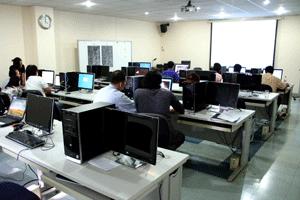
2 Geoinformatics Center Established in 1999 Over 1,600 Graduate students from 40+ countries 14,000 alumni from 74 countries 22,000 short-term trainees from 71 countries Establish in 1959 as a Post Graduate School Catering for higher education in Asia Over 100 faculty members from 26 countries

3 Geoinformatics Center Established in 1999 (Self Funded)
4 Activities of the GIC/AIT Projects and Consulting Works Training Programs, primarily in Asia and the Pacific QZSS GPS Monitoring Station and GNSS Research Emergency Disaster Response Mapping Rapid Mapping Support for Sentinel Asia & IDC Applied Research (DRR, Poverty, Environment, Aquatic..) Exchange Programs: Students, Researchers, Experts Information Sharing and Publications: Journal, Conference, Reports, Manuals etc.
 under the FP7 (Seventh Framework Programmefor")

5 Past GNSS projects Growing Navis Funded by the European GNSS Agency (GSA) under the FP7 (Seventh Framework Programmefor Research and Development). MGA JAXA joint experiment With joint collaboration with JAXA Improving LEX based PPP positioning accuracy.
 Weather measerments Dr. Dinesh Manandhar (The University of Tokyo, visiting faculty in AIT) is supporting us in all the aspects.")
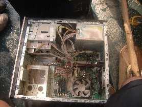
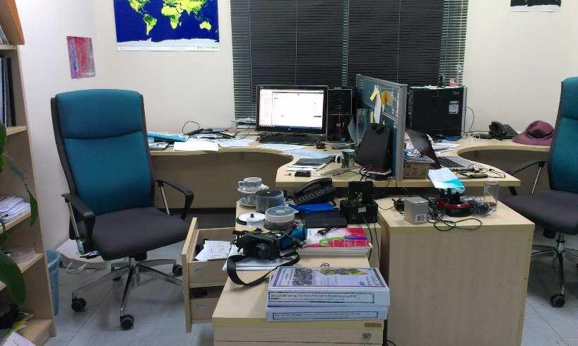
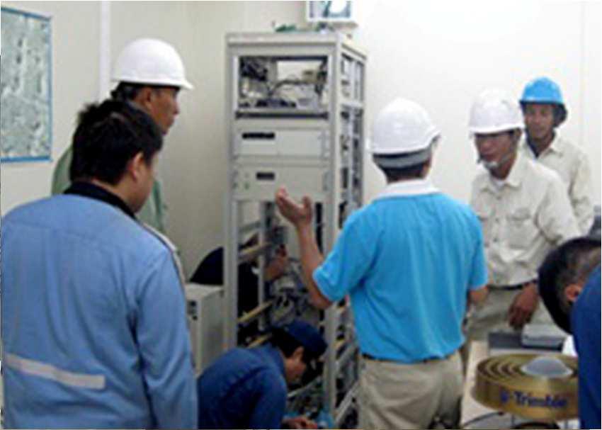
6 QZSS monitoring station/ equipped with other GNSS receivers Trimble-NetR9 receiver QZSS, GPS, GLONASS, GALILEO, BeiDou, IRNSS, and augmentation signals; SBAS, MSAS, SDCM and GAGAN Trimble-Septentrio receiver Furuno receiver Signal quality monitoring (SQM) Weather measerments Dr. Dinesh Manandhar (The University of Tokyo, visiting faculty in AIT) is supporting us in all the aspects. Septentrio Receiver Trimble, NetR9 Receiver Atomic Clock Furuno Receiver Unit 1 Furuno Receiver Unit 2 UPS Network Hub Computer for Real-time Signal Processing Computer for non Real-time Signal Processing
7 Use of QZSS/GNSS monitoring station Base station Establishment Contribute to IGS Research Capacity building Disaster applications, Opportunities for postgraduate students in AIT GNSS Training hub for Asian countries Workshops

8 Use of QZSS/GNSS monitoring station Base station Establishment Contribute to IGS Research Capacity building Disaster applications, Opportunities The Ntripcaster for was postgraduate stopped after the students flood in in AIT 2011, this will be soon started and link to IGS too GNSS Training hub for Asian countries Workshops
9 Use of QZSS/GNSS monitoring station Base station Establishment Contribute to IGS Research Disaster applications, and more Opportunities for postgraduate students in AIT Capacity building GNSS Training hub for Asian countries Workshops


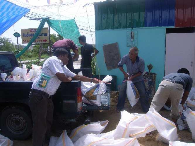
10 Flood in Thailand and AIT 14 th October th October st step 2 nd step


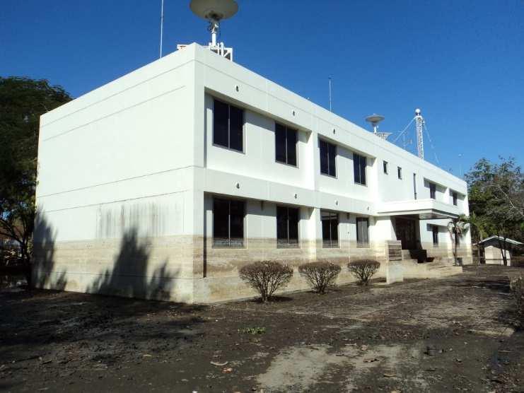
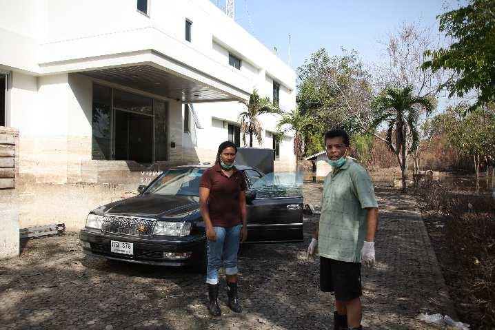
11 Flood in Thailand and AIT AIT was flooded on 21 th October rd October nd November nd December 2011


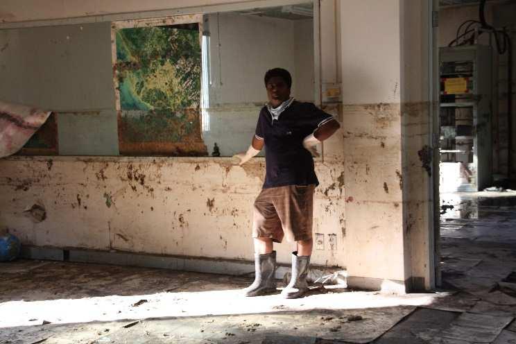
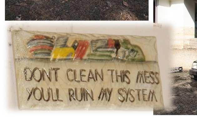
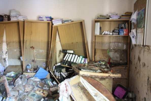
12 Flood in Thailand and AIT Cleaning

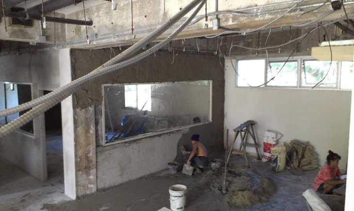


13 Flood in Thailand and AIT Renovation
14 Flood Modeling Flood Models : HEC-RAS, MIKE11, and TELEMAC-2D Flood Modeling Accuracy Accuracy of the DEM Number of river gaging stations Changing ground situation


15 Research Question How to improve the flood modeling accuracy using GNSS? Accurate DEM. Changes with sand bags. Flood height data. Real ground situation * This study was carried out by former staff, Mr. Chatura Wickramasinghe (currently, PhD student at RMIT, Australia)
16 Objective First stage Identify measurable minimum vertical movement using real time PPP(Precise Point Positioning) QZSS-LEX. Develop algorithm to accurately calculate the flood water increasing rate using QZSS-LEX based PPP. Final Target Develop real time flood monitoring sensor network and new flood model that can use the data for real time dynamic flood modeling.


17 System Frame Work GPS Satellites QZSS Satellites QZSS Emergency massage Flood Modeling L1,LEX GSM Network Central Monitoring Station
18 Advantages Highly accurate flood monitoring. Any location Chang data gathering point according to the situation. Accurate mitigation Monitor how ground situation is deviation from the model and response. Sand bag walls will change the water flow. Centralized system. Relatively low implementation cost.
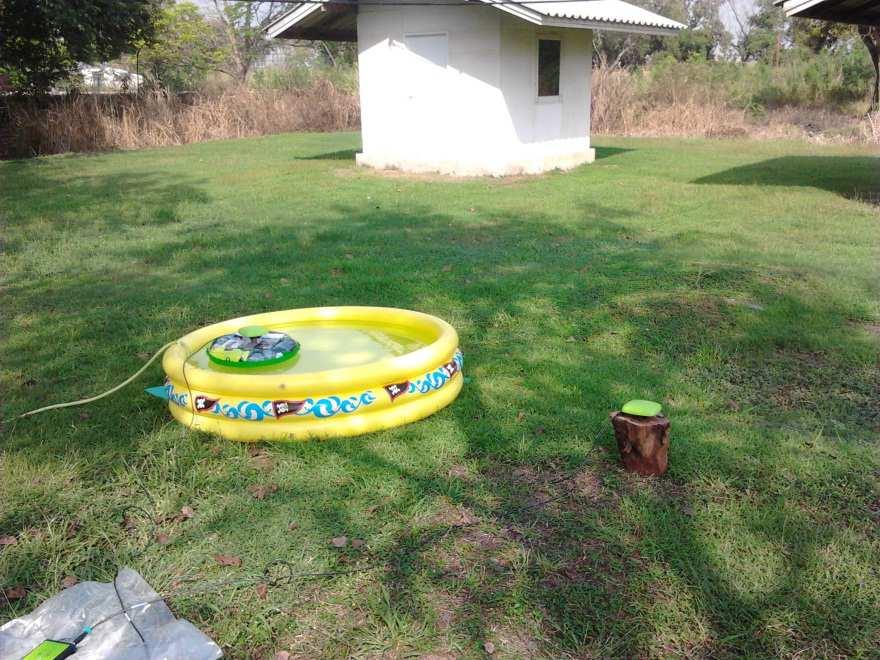


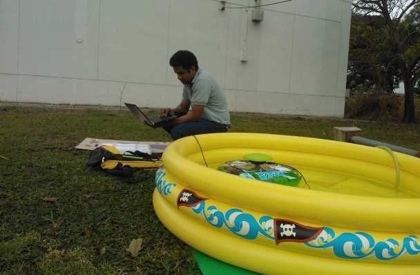
19 Data Collection
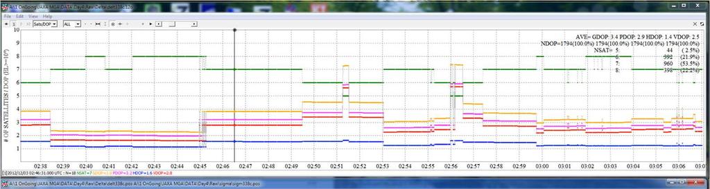
20 Initial observation data Average Water increasing rate cm/sec Linear fit Gradient cm/sec
21 Initial observation data Average Water increasing rate cm/sec Linear fit Gradient cm/sec
22 Initial observation data decreasing water Average Water increasing rate cm/sec Linear fit Gradient 0.03cm/sec

23 Initial observation data Cont..
24 A ongoing project APPLYING SPACE-BASED TECHNOLOGY TO STRENGTHEN DISASTER RESILIENCE Funded by ADB Implementation agencies: AIT (lead), RESTEC, ADRC, PASCO, GEoThings
25 Project at a Glance Budget 2 million USD financed by Japan Fund for Poverty Reduction Duration 2 years( March 2017) Impact Outcome Improvedinformation-based DRM systems and services Improve quality and timeliness of information for disaster preparedness and response using SBT and ICT Implementation AIT (lead), RESTEC, ADRC, PASCO, GEoThings Output 1) Enhanceddisaster-related information collection, sharing, and utilization of applying SBT and ICT in selected communities 2) Expandedknowledge on SBT and ICT applications for DRM in each country and the region 3) Policy guidelines developed regarding sustainable SBT and ICT applications for DRM in each country


26 Pilot Countries


27 Overall Approach


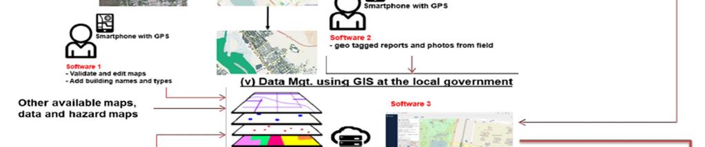
28 Data Management System Integral point of SBT and ICT Data sharing and management system among stakeholders Simple analysis functions for disaster risk Building foundation < 0.5m = possible at-risk area for flooding - Visual condition - Building material - Roof material - Landscape etc
29 Use of QZSS/GNSS monitoring station Base station Establishment Contribute to IGS Research Disaster applications, and more Opportunities for postgraduate students in AIT Capacity building GNSS Training hub for Asian countries Workshops
30 GNSS training hub for Asian countries Geoinformaticscenter has long history of conducting geomatics related programs for Asian countries Association with the University of Tokyo for delivering advanced training programs and workshops We thrive with the partnerships and collaborations: looking for fostering new collaborative research in the field of GNSS and applications
31 Thank You! Contact:
Global Navigation Satellite System (GNSS) for Disaster Mitigation
 for Disaster Mitigation") Global Navigation Satellite System (GNSS) for Disaster Mitigation By Chathura H. Wickramasinghe Geoinformatics Center Asian Institute of Technology Establish in 1959 as a Post Graduate School Catering
Global Navigation Satellite System (GNSS) for Disaster Mitigation By Chathura H. Wickramasinghe Geoinformatics Center Asian Institute of Technology Establish in 1959 as a Post Graduate School Catering
Report on GNSS Training
 Report on GNSS Training Course ID: T141-30 Afghanistan, Australia, Austria, Bangladesh, Bhutan, Cambodia, India, Indonesia, Japan, Maldives, Mongolia, Nepal, The Philippines, Sri Lanka, Tajikistan, Thailand,
Report on a Multi-GNSS Demonstration project in the Asia/Oceania region
 Report on a Multi-GNSS Demonstration project in the Asia/Oceania region - Asia Oceania is the Showcase of New GNSS Era - Japan Aerospace Exploration Agency ICG 5@Turin, Italy October 19, 2010 1 Back Ground
THE XXV FIG International Congress 2014
 THE XXV FIG International Congress 2014 1 ASIA OCEANIA MULTI-GNSS DEMONSTRATION CAMPAIGN Kazutoshi Sato, Hiroaki Tatashita, Wakabayashi Yaka, Hideshi Kakimoto, and Satoshi Kogure Multi-GNSS Asia Secretariat
Invited Guests All Resource Persons Shafa Manzul Dinesh 0 10:30-11:00 Group Photo, Break GIC Staffs :30-12:30 GPS Introduction
 14-JAN-2019 (Day 1), Monday Minutes. Time Course Description Resource 0 08:30-09:00 Registration GIC Staffs 30 09:00-09:30 Opening Ceremony 60 09:30-10:30 Presentation on ICG GIC Presentation Course Introduction
PRELIMINARY PROGRAMME
 ICG EXPERTS MEETING: GLOBAL NAVIGATION SATELLITE SYSTEMS SERVICES 14-18 December 2015 Vienna International Centre, Vienna, Austria Organized by International Committee on Global Navigation Satellite Systems
The technical contribution of QZSS and GNSS to Tsunami early warning system
 0/17 Tsunami Workshop by Sentinel Asia @Sendai International Center Meeting Room 5 The technical contribution of QZSS and GNSS to Tsunami early warning system July 3, 2012 K. Mutoh, J. Yamashita, and S.
The International Scene: How Precise Positioning Will Underpin Critical GNSS Applications
 The International Scene: How Precise Positioning Will Underpin Critical GNSS Applications School of Civil & Environmental Engineering, UNSW, Sydney, Australia Chris Rizos Member of the IGS Governing Board
THE CURRENT STATUS OF ASIA OCEANIA MULTI-GNSS DEMONSTRATION CAMPAIGN. Multi-GNSS Asia Secretariat June 4 th, th ICG Providers Forum
 THE CURRENT STATUS OF ASIA OCEANIA MULTI-GNSS DEMONSTRATION CAMPAIGN 1 Multi-GNSS Asia Secretariat June 4 th, 2012 8 th ICG Providers Forum ASIA OCEANIA MULTI-GNSS DEMONSTRATION CAMPAIGN Multi-GNSS Monitoring
Research Activities and Education in TUMSAT
 Research Activities and Education in TUMSAT 2011/09/07 @ ICG-6 Akio Yasuda Tokyo University of Marine Science & Technology 1 Content Tokyo University of Marine Science and Technology Etchujima Campus of
GNSS Education Activities The University of Tokyo
 GNSS Education Activities The University of Tokyo Dinesh MANANDHAR, Associate Professor Center for Spatial Information Science, The University of Tokyo 6 th NOV 2018 dinesh@iis.u-tokyo.ac.jp Slide : 1
GNSS Low-Cost High-Accuracy Receiver (L-CHAR)
") GNSS Low-Cost High-Accuracy Receiver (L-CHAR) Dinesh Manandhar Center for Spatial Information Science The University of Tokyo Contact Information: dinesh@iis.u-tokyo.ac.jp Slide : 1 High Accuracy Receivers
GNSS Low-Cost High-Accuracy Receiver (L-CHAR) Dinesh Manandhar Center for Spatial Information Science The University of Tokyo Contact Information: dinesh@iis.u-tokyo.ac.jp Slide : 1 High Accuracy Receivers
QZSS/GNSS Application Promotion In Japan
 The 3rd EU-Japan Satellite Positioning Public-Private Roundtable 5 th March 2018 QZSS/GNSS Application Promotion In Japan Dr. Izumi Mikami Satellite Positioning Research and Application Center SPAC,2013
Compact multi-gnss PPP corrections messages for transmission through a 250 bps channel
 Compact multi-gnss PPP corrections messages for transmission through a 250 bps channel Ken Harima, School of Science, RMIT University Suelynn Choy, School of Science, RMIT University Chris Rizos, School
Report on the United Nations/Croatia Workshop on the Applications of Global Navigation Satellite Systems
 United Nations General Assembly Distr.: General 3 September 2013 Original: English Committee on the Peaceful Uses of Outer Space Report on the United Nations/Croatia Workshop on the Applications of Global
One Source for Positioning Success
 novatel.com One Source for Positioning Success RTK, PPP, SBAS OR DGNSS. NOVATEL CORRECT OPTIMIZES ALL CORRECTION SOURCES, PUTTING MORE POWER, FLEXIBILITY AND CONTROL IN YOUR HANDS. NovAtel CORRECT is the
GNSS Accuracy Improvements through Multipath Mitigation with New Signals and services
 GNSS Accuracy Improvements through Multipath Mitigation with New Signals and services Andrey Veytsel, Ph.D Moscow Technical University 10 Meeting of the International Committee on Global Navigation Satellite
Status of Multi-GNSS Monitoring Network Establishment
 Status of Multi-GNSS Monitoring Network Establishment Japan Aerospace Exploration Agency Satoshi Kogure ICG-6 6 WG-A/D cross-session session @Tokyo, JAPAN 7 September, 2011 Contents Introduction Overview
QZSS and LEX Signal. Performance of Real-Time Precise Point Positioning Using MADOCA-LEX Augmentation Messages. Outline
 Performance of Real-Time Precise Point Positioning Using MADOCA-LEX Augmentation Messages Suelynn Choy 1, Ken Harima 1, Mohammad Choudhury 2, Yong Li 2, Yaka Wakabayashi 3, Thomas Grinter 4, Satoshi Kogure
Testing of GNSS Dual-Frequency with Smartphones
 Testing of GNSS Dual-Frequency with Smartphones Towards better location performance in mass market applications P. Crosta, G. Galluzzo, R. Orus, R. Lucas, ESA J. Redelkiewicz, GSA ESA UNCLASSIFIED - For
Building Sustainable and Resilient Communities
 2015/SOM1/EPWG/032 Agenda Item: 8.6 Building Sustainable and Resilient Communities Purpose: Information Submitted by: China 7 th Emergency Preparedness Working Group Meeting Subic, Philippines 28-29 January
Asia Oceania Multi-GNSS Demonstration Campaign
 Asia Oceania Multi-GNSS Demonstration Campaign Kazutoshi SATO, Hiroaki TATESHITA, Yaka WAKABAYASHI, Hideshi KAKIMOTO, and Satoshi KOGURE, Key words: Multi-GNSS, Asia, Oceania, MGA, workshop SUMMARY Over
Preparing for the Future The IGS in a Multi-GNSS World
 Preparing for the Future The IGS in a Multi-GNSS World O. Montenbruck DLR/GSOC 1 The International GNSS Service is a federation of more than 200 institutions and organizations worldwide a Service of the
Quasi-Zenith Satellite System (QZSS)
") Transmission of Augmentation Corrections using the Japanese QZSS for Real-Time Precise Point Positioning in Australia Ken Harima 1, Suelynn Choy 1, Mazher Choudhury 2, Chris Rizos 2, Satoshi Kogure 3 1
Transmission of Augmentation Corrections using the Japanese QZSS for Real-Time Precise Point Positioning in Australia Ken Harima 1, Suelynn Choy 1, Mazher Choudhury 2, Chris Rizos 2, Satoshi Kogure 3 1
THE CURRENT STATUS OF ASIA OCEANIA MULTI-GNSS DEMONSTRATION CAMPAIGN
 THE CURRENT STATUS OF ASIA OCEANIA MULTI-GNSS DEMONSTRATION CAMPAIGN 1 7th Meeting of the International Committee on Global Navigation Satellite Systems (ICG) November 5-9, 2012 @Beijing, China ASIA OCEANIA
International Committee on Global Navigation Satellite Systems
 International Committee on Global Navigation Satellite Systems Training Course on Global Navigation Satellite Systems 14 18 January 2019, Asian Institute of Technology, Bangkok, Thailand Sharafat Gadimova
Prospect for Global Positioning Augmentation Service by QZSS
 Prospect for Global Positioning Augmentation Service by QZSS Global Positioning Augmentation Service Corporation Director, Yoshikatsu Iotake Feb. 6, 2018 Copyright 2018 Global Positioning Augmentation
MGA Webinar Series : 1 Very Cheap RTK Receivers: Changing the Landscape of Positioning Services
 MGA Webinar Series : 1 Very Cheap RTK Receivers: Changing the Landscape of Positioning Services Dinesh Manandhar Center for Spatial Information Science The University of Tokyo Contact Information: dinesh@iis.u-tokyo.ac.jp
European GNSS Service Centre (GSC) US Coast Guard Navigation Center (NAVCEN) Cooperation
 US Coast Guard Navigation Center (NAVCEN) Cooperation") European GNSS Service Centre (GSC) US Coast Guard Navigation Center (NAVCEN) Cooperation Boulder, November 2015 European GNSS Agency (GSA) US Coast Guard Navigation Center (NAVCEN) The centres: GSC and
European GNSS Service Centre (GSC) US Coast Guard Navigation Center (NAVCEN) Cooperation Boulder, November 2015 European GNSS Agency (GSA) US Coast Guard Navigation Center (NAVCEN) The centres: GSC and
Concept of Periodic Synthesis Report
 Concept of Periodic Synthesis Report There is no lack of scientific knowledge, but it is fragmented and not easily accessible to policy makers and practitioners. The Sendai Science and Technology Roadmap
Relative positioning with Galileo E5 AltBOC code measurements
 Relative positioning with Galileo E5 AltBOC code measurements Dissertation submitted to the University of Liège in requirements for a Master s degree in Geomatics and Geometrology Cécile Deprez PhD Candidate
Lecture-1 CHAPTER 2 INTRODUCTION TO GPS
 Lecture-1 CHAPTER 2 INTRODUCTION TO GPS 2.1 History of GPS GPS is a global navigation satellite system (GNSS). It is the commonly used acronym of NAVSTAR (NAVigation System with Time And Ranging) GPS (Global
Real-time Stream Conversion to RTCM-3 MSM and RINEX-3 in IGS/MGEX Context
 Real-time Stream Conversion to RTCM-3 MSM and RINEX-3 in IGS/MGEX Context Georg Weber (BKG), Ken MacLeod (NRCan), Leos Mervart (CTU), Oliver Montenbruck (DLR), James Perlt (BKG), Dirk Stöcker (Alberding),
Operation and Development of BeiDou Navigation Satellite System
 Operation and Development of BeiDou Navigation Satellite System Jing Li IAIN 2015, 20 23 October Prague, Czech Republic 2 01 03 Plan and Policy 02 Status and Near-term Goal International Cooperation 3
Introduction to GNSS Base-Station
 Introduction to GNSS Base-Station Dinesh Manandhar Center for Spatial Information Science The University of Tokyo Contact Information: dinesh@iis.u-tokyo.ac.jp Slide : 1 Introduction GPS or GNSS observation
Integrated InnovatIve SolutI ons
 Technology Engineering Environment Development Management Integrated InnovatIve SolutI ons www.solutions.ait.asia Asian Institute of Technology WhO We are AIT Solutions (AITS), formerly AIT Consulting,
Geoscience & Positioning, Navigation and Timing Services for Canadians
 Geoscience & Positioning, Navigation and Timing Services for Canadians Calvin Klatt, Ph.D. Director and Chief Geodesist Natural Resources Canada / Directeur et géodésien principal Ressources naturelles
Satellite-Based Augmentation System (SBAS) Integrity Services
 Integrity Services") Satellite-Based Augmentation System (SBAS) Integrity Services Presented To: Munich, Germany Date: March 8, 2010 By: Leo Eldredge, Manager GNSS Group, FAA FAA Satellite Navigation Program 2 Wide Area Augmentation
Satellite-Based Augmentation System (SBAS) Integrity Services Presented To: Munich, Germany Date: March 8, 2010 By: Leo Eldredge, Manager GNSS Group, FAA FAA Satellite Navigation Program 2 Wide Area Augmentation
THE CURRENT STATUS OF ASIA OCEANIA MULTI-GNSS DEMONSTRATION CAMPAIGN
 THE CURRENT STATUS OF ASIA OCEANIA MULTI-GNSS DEMONSTRATION CAMPAIGN 1 Multi-GNSS Asia Secretariat July 25, 2012 UN ICG WG-A intersession Mtg. Session4 @UWM Olstzyn, Poland ASIA OCEANIA MULTI-GNSS DEMONSTRATION
Fast convergence of Trimble CenterPoint RTX by regional augmentation
 Fast convergence of Trimble CenterPoint RTX by regional augmentation Dr. Ralf Drescher Trimble Terrasat GmbH, Munich EGU General Assembly 2015, Vienna Thursday, 16 April 2015 Outline Introduction CenterPoint
The added value of new GNSS to monitor the ionosphere
 The added value of new GNSS to monitor the ionosphere R. Warnant 1, C. Deprez 1, L. Van de Vyvere 2 1 University of Liege, Liege, Belgium. 2 M3 System, Wavre, Belgium. Monitoring TEC for geodetic applications
The Multi-Mode Time Transfer Based on GNSS
 The Multi-Mode Time Transfer Based on GNSS Shuhong ZHAO, Haibo YUAN National Time Service Center of CAS, PR China 2017.11 The Content of Report ü Background ü Principle of GNSS CV Time Transfer ü Results
10 th APEC TRANSPORTATION MINISTERIAL MEETING 7 th October 2017 Port Moresby, Papua New Guinea Ministerial Statement
 10 th APEC TRANSPORTATION MINISTERIAL MEETING 7 th October 2017 Port Moresby, Papua New Guinea Ministerial Statement 1. We, the Ministers responsible for transportation, met in Port Moresby, Papua New
Multi-GNSS Environment. Chris Rizos UNSW, Australia President IAG
 Multi-GNSS Environment Chris Rizos UNSW, Australia President IAG Visit official GNSS web sites: GPS - www.navcen.uscg.gov & www.gps.gov GLONASS - glonass-ianc.rsa.ru/en/ Galileo - www.esa.int/our_activities/navigation
Real-Time and Multi-GNSS Key Projects of the International GNSS Service
 Real-Time and Multi-GNSS Key Projects of the International GNSS Service Urs Hugentobler, Chris Rizos, Mark Caissy, Georg Weber, Oliver Montenbruck, Ruth Neilan EUREF 2013 Symposium Budapest, Hungary, May
FACILITATING EU-ASIA INDUSTRIAL COOPERATION ON DOWNSTREAM GNSS. Tokyo, 8 October 2014 Fabrizio Mura
 FACILITATING EU-ASIA INDUSTRIAL COOPERATION ON DOWNSTREAM GNSS Tokyo, 8 October 2014 Fabrizio Mura OBJECTIVES: FACILITATE EU-ASIA INDUSTRIAL COOPERATION ON DOWNSTREAM GNSS 1. Define a strategy for the
Indoor Navigation and the. Conferest Demo App
 Indoor Navigation and the Presented at the FIG Working Week 2017, May 29 - June 2, 2017 in Helsinki, Finland Conferest Demo App Dept. of Navigation and Positioning Finnish Geospatial Research Institute
High Precision Navigation Capabilities(L1-SAIF) and Applications Using Japanese Quasi-Zenith Satellite System (QZSS)
 and Applications Using Japanese Quasi-Zenith Satellite System (QZSS)") High Precision Navigation Capabilities(L1-SAIF) and Applications Using Japanese Quasi-Zenith Satellite System (QZSS) ICG WG-B Application SG Meeting Munich, Germany March 12, 2012 Satellite Positioning
High Precision Navigation Capabilities(L1-SAIF) and Applications Using Japanese Quasi-Zenith Satellite System (QZSS) ICG WG-B Application SG Meeting Munich, Germany March 12, 2012 Satellite Positioning
King AbdulAziz University. Faculty of Environmental Design. Geomatics Department. Mobile GIS GEOM 427. Lecture 3
 King AbdulAziz University Faculty of Environmental Design Geomatics Department Mobile GIS GEOM 427 Lecture 3 Ahmed Baik, Ph.D. Email: abaik@kau.edu.sa Eng. Fisal Basheeh Email: fbasaheeh@kau.edu.sa GNSS
GNSS in Maritime and Education in Egypt
 GNSS in Maritime and Education in Egypt GNSS IN MARITIME PORTS SHIPS PORTS WATERWAYS GNSS maritime applications will help to improve: navigation. Ship operations. Traffic management. Seaport operations.
GNSS Technology Update
 GNSS Technology Update Speaker: Eric Gakstatter Contributing Editor GPS World Editor - Geospatial Solutions Presented at: Association of Petroleum Surveying & Geomatics Houston, TX April 7, 2015 Agenda
Development of Hong Kong GNSS infrastructure
 Development of Hong Kong GNSS infrastructure Wu Chen Department of Land Surveying and Geoinformatics (LSGI) Hong Kong Polytechnic University Hong Kong 1 Research Areas Research Areas GNSS Positioning and
GNSS Analysis with Galileo Observations in the Subnetwork of the BEK Analysis Centre
 GNSS Analysis with Galileo Observations in the Subnetwork of the BEK Analysis Centre Christof Völksen Bavarian Academy of Sciences and Humanities (BAdW) Tomasz Liwosz Warsaw University of Technology, Warsaw,
In preparing any country program or strategy, financing any project, or by making any designation of or reference to a particular territory or
 April 2018 Quarterly Summary Report on Approved (A) Transaction Technical Assistance Not Exceeding $5,000,000; (B) Knowledge and Support Technical Assistance Projects Not Exceeding $225,000; and (C) Technical
Asia Oceania Regional Workshop on GNSS Precise Point Positioning Experiment by using QZSS LEX
 Asia Oceania Regional Workshop on GNSS 2010 Precise Point Positioning Experiment by using QZSS LEX Tomoji TAKASU Tokyo University of Marine Science and Technology Contents Introduction of QZSS LEX Evaluation
GNSS (GPS) buoy array in the Pacific for natural disaster mitigation. Teruyuki KATO Earthquake Research Institute the University of Tokyo, Japan
 buoy array in the Pacific for natural disaster mitigation. Teruyuki KATO Earthquake Research Institute the University of Tokyo, Japan") GNSS (GPS) buoy array in the Pacific for natural disaster mitigation Teruyuki KATO Earthquake Research Institute the University of Tokyo, Japan 1 (Modified from Oki & Koketsu, 2011) Historical megaquakes
GNSS (GPS) buoy array in the Pacific for natural disaster mitigation Teruyuki KATO Earthquake Research Institute the University of Tokyo, Japan 1 (Modified from Oki & Koketsu, 2011) Historical megaquakes
International Cooperation Research Center, China Satellite Navigation Office
 International Cooperation Research Center, ICG-8, Nov 10, 2013 Dubai Overview BeiDou Navigation Satellite System (hereinafter referred to as BDS") has provide regional service by the end of 2012, which
Assessment of GNSS Ionospheric Scintillation and TEC Monitoring Using the Multi-constellation GPStation-6 Receiver
 Assessment of GNSS Ionospheric Scintillation and TEC Monitoring Using the Multi-constellation GPStation-6 Receiver Rod MacLeod Regional Manager Asia/Pacific NovAtel Australia Pty Ltd Outline Ionospheric
in Developing Countries in FY2008
 Study on Economic Partnership Projects in Developing Countries in FY2008 Study on Research and Development Center for Space Technology of Vietnam Academy of Science and Technology in Hoa Lac in Socialist
The 21st Session of the Asia-Pacific Regional Space Agency Forum (APRSAF): Dawn of a New Decade
: Dawn of a New Decade") The 21st Session of the Asia-Pacific Regional Space Agency Forum (APRSAF): Dawn of a New Decade 52 nd Session of Scientific and Technical Subcommittee Kazuhiro MIYAZAKI Office for Space Utilization Promotion,
The 21st Session of the Asia-Pacific Regional Space Agency Forum (APRSAF): Dawn of a New Decade 52 nd Session of Scientific and Technical Subcommittee Kazuhiro MIYAZAKI Office for Space Utilization Promotion,
Timing & Synchronisation
 Timing & Synchronisation With an analysis of GNSS User Technology ISSUE 4 Excerpt from the GNSS MARKET REPORT, ISSUE 4 (2015) 72 Timing & Synchronisation GNSS applications This chapter addresses the following
Multi-Constellation GNSS Precise Point Positioning using GPS, GLONASS and BeiDou in Australia
 International Global Navigation Satellite Systems Society IGNSS Symposium 2015 Multi-Constellation GNSS Precise Point Positioning using GPS, GLONASS and BeiDou in Australia Xiaodong Ren 1,Suelynn Choy
GLOF project in Bhutan
 Mt. Khang Bum (6494m) GLOF project in Bhutan Masaru ARAKIDA (Mr) Makoto IKEDA (Mr) Asian Disaster Reduction Center Table of Contents 1. Outline of GLOF Project 2. Past Disaster 3. Output of GLOF Project
Enhancing global PPP with Local Ionospheric Corrections
 Enhancing global PPP with Local Ionospheric Corrections Suelynn Choy 1, Ken Harima 1, Satoshi Kogure 2 1 School of Mathematical and Geospatial Sciences, RMIT University, Australia 2 Satellite Navigation
Challenges and Solutions for GPS Receiver Test
 Challenges and Solutions for GPS Receiver Test Presenter: Mirin Lew January 28, 2010 Agenda GPS technology concepts GPS and GNSS overview Assisted GPS (A-GPS) Basic tests required for GPS receiver verification
FY18 CIF Business Plan and Budget (SUMMARY)
") Joint CTF-SCF.17/3 May 23, 2017 Joint Meeting of the CTF and SCF Trust Fund Committees Washington, DC June 7, 2017 Agenda Item 3 FY18 CIF Business Plan and Budget (SUMMARY) PROPOSED DECISION The Joint
Joint CTF-SCF.17/3 May 23, 2017 Joint Meeting of the CTF and SCF Trust Fund Committees Washington, DC June 7, 2017 Agenda Item 3 FY18 CIF Business Plan and Budget (SUMMARY) PROPOSED DECISION The Joint
The last 25 years - GPS to multi-gnss: from a military tool to the most widely used civilian positioning solution
 1 The last 25 years - GPS to multi-gnss: from a military tool to the most widely used civilian positioning solution B. Hofmann-Wellenhof Institute of Geodesy / Navigation, Graz University of Technology
The Sustainable Tourism Programme of the 10-Year Framework of Programmes on Sustainable Consumption and Production
 The Sustainable Tourism Programme of the 10-Year Framework of Programmes on Sustainable Consumption and Production Generating collective impact Scaling up and replicating Programmatic implementation Helena
European GNSS Applications in H2020
 European GNSS Applications in H2020 Countdown to H2020 12.12.2013, Brussels Carmen Aguilera European GNSS Agency Agenda European GNSS Agency EU-GNSS market potential FP7- experience and results H2020 opportunities
ION GNSS Galileo, an ace up in the sleeve for PPP techniques
 ION GNSS+ 2016 an ace up in the sleeve for PPP techniques September 15 TH, 2016 Session D3: High Precision GNSS Positioning I. Rodríguez-Pérez, L. Martínez-Fernández, G. Tobías-González, J. D. Calle-Calle,
Future of GNSS Receivers. Éamonn Glennon
 Future of GNSS Receivers Éamonn Glennon Future of GNSS Receivers? What have we got now? What do customers want? What does government want? What are the problems with current receivers? What type of receivers?
Bhutan: Adapting to Climate Change through Integrated Water Resources Management
 Completion Report Project Number: 46463-002 Technical Assistance Number: 8623 August 2017 Bhutan: Adapting to Climate Change through Integrated Water Resources Management This document is being disclosed
Assessment of the Contribution of QZSS Combined GPS/BeiDou Positioning in Asia-Pacific Areas
 Assessment of the Contribution of QZSS Combined GPS/BeiDou Positioning in Asia-Pacific Areas Yize Zhang, Nobuaki Kubo, Junping Chen, Hu Wang and Jiexian Wang Abstract Three QZSS satellites are launched
GBAS FOR ATCO. June 2017
 GBAS FOR ATCO June 2017 Disclaimer This presentation is for information purposes only. It should not be relied on as the sole source of information, and should always be used in the context of other authoritative
BeiDou: Bring the World and China to Your Doorstep
 IGS Workshop 2012-ICG Working Group A BeiDou: Bring the World and China to Your Doorstep China Satellite Navigation Office 2012.7.25 Olsztyn, Poland 1 Contents I. Development Schemes II. Performance III.
Preparedness, Response and Assessment of Oil Spill (PRAOS) Phase I
 Phase I") Preparedness, Response and Assessment of Oil Spill (PRAOS) Phase I Contents Introduction of PRAOS I Outcomes of PRAOS I Evaluation of PRAOS I Future Outlook 70% of oil consumed globally is transported
Preparedness, Response and Assessment of Oil Spill (PRAOS) Phase I Contents Introduction of PRAOS I Outcomes of PRAOS I Evaluation of PRAOS I Future Outlook 70% of oil consumed globally is transported
International Efforts for Transparency and Confidence-Building Measures (TCBM) and Japan s Contribution
 and Japan s Contribution") International Efforts for Transparency and Confidence-Building Measures (TCBM) and Japan s Contribution Atsushi SAITO 4 th March, 2016 1 1. International Rules On Outer Space (1) Committee on the Peaceful
International Efforts for Transparency and Confidence-Building Measures (TCBM) and Japan s Contribution Atsushi SAITO 4 th March, 2016 1 1. International Rules On Outer Space (1) Committee on the Peaceful
The topic we are going to see in this unit, the global positioning system, is not directly related with the computer networks we use everyday, but it
 The topic we are going to see in this unit, the global positioning system, is not directly related with the computer networks we use everyday, but it is indeed a kind of computer network, as the specialised
INTEROPERABILITY OF THE GNSS'S FOR POSITIONING AND TIMING. A. Caporali, L. Nicolini University of Padova, Italy
 INTEROPERABILITY OF THE GNSS'S FOR POSITIONING AND TIMING A. Caporali, L. Nicolini University of Padova, Italy Outlook Monitor 31 European GNSS sites with 5 different receivers (Javad, Leica, Septentrio,
Japan s View on Opportunities and New Approaches for Enhanced Multinational S&T Co-operation
 Japan s View on Opportunities and New Approaches for Enhanced Multinational S&T Co-operation March 25, 2009 Kimikazu IWASE Deputy Director General, Science and Technology Policy Bureau Ministry of Education,
European GNSS Evolution
 Ref. Ares(204)902599 - /06/204 European GNSS Evolution Hermann Ebner Galileo and EGNOS Programme Management DG Enterprise and Industry Content Introduction 2 2 Major Challenges for EGNSS Evolution 3 EGNSS
Introduction to Global Navigation Satellite System (GNSS) Signal Structure
 Signal Structure") Introduction to Global Navigation Satellite System (GNSS) Signal Structure Dinesh Manandhar Center for Spatial Information Science The University of Tokyo Contact Information: dinesh@iis.u-tokyo.ac.jp
Introduction to Global Navigation Satellite System (GNSS) Signal Structure Dinesh Manandhar Center for Spatial Information Science The University of Tokyo Contact Information: dinesh@iis.u-tokyo.ac.jp
Signals, and Receivers
 ENGINEERING SATELLITE-BASED NAVIGATION AND TIMING Global Navigation Satellite Systems, Signals, and Receivers John W. Betz IEEE IEEE PRESS Wiley CONTENTS Preface Acknowledgments Useful Constants List of
International Committee on Global Navigation Satellite Systems (ICG)
") International Committee on Global Navigation Satellite Systems (ICG) A forum to discuss global navigation satellite systems to benefit people around the world Sharafat Gadimova United Nations Office for
International Committee on Global Navigation Satellite Systems (ICG) A forum to discuss global navigation satellite systems to benefit people around the world Sharafat Gadimova United Nations Office for
International Committee on Global Navigation Satellite Systems (ICG) and its Programme on Global Navigation Satellite Systems (GNSS) Applications
 and its Programme on Global Navigation Satellite Systems (GNSS) Applications") and its Programme on Global Navigation Satellite Systems (GNSS) Applications Sharafat Gadimova ICG Executive Secretariat Office for Outer Space Affairs United Nations Office at Vienna a forum to discuss
and its Programme on Global Navigation Satellite Systems (GNSS) Applications Sharafat Gadimova ICG Executive Secretariat Office for Outer Space Affairs United Nations Office at Vienna a forum to discuss
The Promise and Challenges of Accurate Low Latency GNSS for Environmental Monitoring and Response
 Technical Seminar Reference Frame in Practice, The Promise and Challenges of Accurate Low Latency GNSS for Environmental Monitoring and Response John LaBrecque Geohazards Focus Area Global Geodetic Observing
Report of the Working Group B: Enhancement of Global Navigation Satellite Systems (GNSS) Services Performance
 Services Performance") Report of the Working Group B: Enhancement of Global Navigation Satellite Systems (GNSS) Services Performance 1. The Working Group on Enhancement of Global Navigation Satellite Systems (GNSS) Service Performance
Report of the Working Group B: Enhancement of Global Navigation Satellite Systems (GNSS) Services Performance 1. The Working Group on Enhancement of Global Navigation Satellite Systems (GNSS) Service Performance
An Industry View on Realistic Benefits for High Precision GNSS Applications due to GNSS Modernisation The Future of High Precision GNSS
 An Industry View on Realistic Benefits for High Precision GNSS Applications due to GNSS Modernisation The Future of High Precision GNSS Bernhard Richter GNSS Business Director at Leica Geosystems 1 Content
Development of BeiDou Navigation Satellite System
 The 8 th Meeting of the International Committee on GNSS Development of BeiDou Navigation Satellite System China Satellite Navigation Office Dubai, UAE November, 2013 Contents Contents 1. Objectives and
PageNET: In Support of the Surveying Community
 Philippine Active Geodetic Network : In Support of the Surveying Community ICG Experts Meeting: Global Navigation Satellite Systems Services Vienna International Center, Vienna, Austria December 14-18,
Time and frequency transfer methods based on GNSS. LIANG Kun, National Institute of Metrology(NIM), China
, China") Time and frequency transfer methods based on GNSS LIANG Kun, National Institute of Metrology(NIM), China Outline Remote time and frequency transfer GNSS time and frequency transfer methods Data and results
Time and frequency transfer methods based on GNSS LIANG Kun, National Institute of Metrology(NIM), China Outline Remote time and frequency transfer GNSS time and frequency transfer methods Data and results
The Global Positioning System II Field Experiments
 The Global Positioning System II Field Experiments 5-1 Mexico DGPS Field Campaign Cenotes in Tamaulipas, MX, near Aldama 5-2 Are Cenote Water Levels Related? 5-3 DGPS Static Survey of Cenote Water Levels
Beginners Guide to GPS Elevation Plus an Update on GPS Technology
 Beginners Guide to GPS Elevation Plus an Update on GPS Technology A TMS Presentation By: Jon Aschenbach Summerlake Enterprises 919 36 th Place Forest Grove, OR 97116 503-707-6236 Coeur d Alene, ID April,
Current Status of the Japanese Quasi-Zenith Satellite System (QZSS)
") Current Status of the Japanese Quasi-Zenith Satellite System (QZSS) 12 November 2008 Koji TERADA QZSS Project Manager Japan Aerospace Exploration Agency Contents Introduction Concept of the QZSS System
Current Status of the Japanese Quasi-Zenith Satellite System (QZSS) 12 November 2008 Koji TERADA QZSS Project Manager Japan Aerospace Exploration Agency Contents Introduction Concept of the QZSS System
Fielding of Consultants 04 September November February July 2004
 TECHNICAL ASSISTANCE COMPLETION REPORT Division: AFRM TA No. and Name TA: AFG 3875: Disaster Preparedness and Management Capacity Building Executing Agency: Source of Funding: TASF Department of Disaster
GNSS Programme. Overview and Status in Europe
 GNSS Programme Overview and Status in Europe Inaugural Forum Satellite Positioning Research and Application Center 23 April 2007 Tokyo Presented by Thomas Naecke (European Commission) Prepared by Daniel
Introduction to Global Navigation Satellite System (GNSS) Module: 1
 Module: 1") Introduction to Global Navigation Satellite System (GNSS) Module: 1 Dinesh Manandhar Center for Spatial Information Science The University of Tokyo Contact Information: dinesh@iis.u-tokyo.ac.jp Slide :
Introduction to Global Navigation Satellite System (GNSS) Module: 1 Dinesh Manandhar Center for Spatial Information Science The University of Tokyo Contact Information: dinesh@iis.u-tokyo.ac.jp Slide :
Protection Augmentation Toughness and Alternatives of GNSS. Melaha 2016 Concord Al-Salam Hotel Cairo, April 25,2016 Refaat Rashad
 Protection Augmentation Toughness and Alternatives of GNSS Melaha 2016 Concord Al-Salam Hotel Cairo, April 25,2016 Refaat Rashad Road Map of the Presentation 1- How Good are GNSS 2- How Vulnerable are
GPS/WAAS Program Update
 GPS/WAAS Program Update UN/Argentina Workshop on the Applications of GNSS 19-23 March 2018 Cordoba, Argentina GNSS: A Global Navigation Satellite System of Systems Global Constellations GPS (24+3) GLONASS
Approach to the era of Multi-GNSS (GEONET by GSI : part2)
") Approach to the era of Multi-GNSS (GEONET by GSI : part2) Tetsuro IMAKIIRE (Geospatial Information Authority of Japan) Contents 1. Multi GNSS environment 1.1 Expansion of GNSS 1.2 QZSS 2. Utility of Multi
Approach to the era of Multi-GNSS (GEONET by GSI : part2) Tetsuro IMAKIIRE (Geospatial Information Authority of Japan) Contents 1. Multi GNSS environment 1.1 Expansion of GNSS 1.2 QZSS 2. Utility of Multi