No AUGUST 2013 UNITED STATES OF AMERICA. Contents
|
|
|
- Audra Francine Shepherd
- 5 years ago
- Views:
Transcription


1 35 31 AUGUST 2013 UNITED STATES OF AMERICA Published Weekly by the National Geospatial-Intelligence Agency Prepared Jointly with the National Ocean Service and U.S. Coast Guard Contents Section I Chart Corrections I-1.1 Chartlets / Depth Tabulations / Notes I-2.1 Charts Affected by Notice to Mariners I-3.1 Section II NGA/DLIS Catalog Corrections II-1.1 Navigation Publications Corrections II-2.1 USCG Light List Corrections / Radiobeacon Corrections II-3.1 NGA List of Lights / Radiobeacon / DGPS Corrections II-4.1 Publications Affected by Notice to Mariners II-5.1 Section III Broadcast Warnings / MARAD Advisories / Special Warnings III-1.1 Marine Information III-2.1 Visit the Maritime Safety Web site at
2 IMPORTANT INFORMATION The Notice to Mariners is published by the National Geospatial-Intelligence Agency (NGA), under the authority of Department of Defense Directive , to advise mariners of important matters affecting navigational safety, including new hydrographic discoveries, changes in channels and navigational aids, etc. (U.S. Code Title 10, Sec. 442 and Title 44, Sec refer). Nothing in the arrangement of information implies endorsement or acceptance by NGA in matters affecting the status and boundaries of States and territories. The Notice to Mariners presents corrective information affecting charts, NGA/DLIS Catalog of Maps Charts and Related Products, Coast Pilots, USCG Light Lists, NGA List of Lights and other products produced by the National Geospatial-Intelligence Agency, National Ocean Service and U.S. Coast Guard. Information for the Notice to Mariners is contributed by the following Agencies: National Geospatial-Intelligence Agency (NGA) (Department of Defense) for waters outside the territorial limits of the United States; National Ocean Service (NOS) (Department of Commerce), which is charged with the surveys and charting of the coasts and harbors of the United States and its territories; the U.S. Coast Guard (USCG) (Department of Homeland Security), which is responsible for the safety of life at sea and the establishment and operation of aids to navigation; and the U.S. Army Corps of Engineers (Department of Defense), which is charged with the improvement of rivers and harbors of the United States. In addition, important contributions are made by foreign hydrographic offices and cooperating observers of all nationalities. For further information concerning NGA hydrographic products and services, including the Maritime Safety Web site, users may contact: Name Telephone DSN FAX Maritime Safety Office N/A World Wide Navigational Warning Service Maritime Safety Web site N/A Notice to Mariners: Regions 1 and Notice to Mariners: Regions 3 thru Sailing Directions, Fleet Guides Navigation Publications NGA/DLIS Catalog of Maps Charts and Related Products The Maritime Safety Web site can be accessed directly at For your convenience NGA provides four addresses. For information affecting Notice to Mariners use MCDNtM@nga.mil, for information affecting Sailing Directions and all other navigational publications use MCDPubs@nga.mil, for information concerning the Maritime Safety Web site, use webmaster_nss@nga.mil and for information concerning the World Wide Navigational Warning Service, use NavSafety@nga mil. Mariners are requested to notify NGA of discrepancies in charts and publications, using the Marine Information Report and Suggestion Sheet at the back of this Notice to Mariners. This form should also be used to report permanent changes, additions, or deletions from charted or published information. Reports which constitute an immediate hazard to navigation should be sent to the nearest NAVAREA Coordinator via coast radio stations. All reports are greatly appreciated. Cover Photo: USS LEYTE GULF (CG-55) is the ninth Ticonderoga-class AEGIS Guided Missile Cruiser and the eighth built by Ingalls Shipbuilding in Pascagoula, MS. She commemorates the largest naval battle in modern history, fought October 1944 in the Philippines. The battle marked the end of centuries of naval warfare tradition employing battleships, and was showcased by three separate primary engagements: The Battle of Surigao Straits, the Battle off Samar Island, and the Battle of Cape Engano. Called the last of the great sea battles, the Battle of Leyte Gulf used every known weapon of naval war, except mines, and in sheer destruction the battle has no rival in naval history. Ticonderoga-class cruisers are multi-mission surface combatants [Air Warfare (AW), Undersea Warfare (USW), Naval Surface Fire Support (NSFS) and Surface Warfare (SUW)] capable of supporting carrier battle groups, amphibious forces, or of operating independently and as flagships of surface action groups. LEYTE GULF is 567 feet in length, has a beam of 55 feet, displaces 9600 tons fully loaded and is powered by four General Electric LM 2500 gas turbine engines that provide 80,000 shaft horsepower total. Her armament includes the MK-41 vertical launching system Standard Missile; Vertical Launch ASROC Missile; Tomahawk Cruise Missile; six MK-46 torpedoes (from two triple mounts); two MK-45 5-inch/54 caliber lightweight guns and two Phalanx close-inweapons systems. She also employs two SH-60 Seahawk (LAMPS III) helicopters. The homeport of USS LEYTE GULF is Norfolk, VA. ii
3 INFORMATION OF SPECIAL INTEREST OR IMPORTANCE TO MARINERS NM 35/13 National Geospatial-Intelligence Agency Springfield, VA SPECIAL ANNOUNCEMENTS NEW PRODUCTS OR SERVICES IMPORTANT CHANGES 31 August 2013 CHART TH EDITION DEFECTIVE THE 4TH EDITION OF CHART DATED MAY 11, 2013 WAS FOUND TO BE DEFECTIVE AND WILL NOT BE ANNOUNCED IN THE NOTICE TO MARINERS. A NEW 5TH EDITION IS CURRENTLY IN THE PRODUCTION PROCESS. MARINERS SHOULD DESTROY THE 4TH EDITION IAW DODI AND CONTINUE TO USE AND NOT DISCARD THE 3RD EDTION OF THIS CHART UNTIL A NEW EDITION HAS BEEN ANNOUNCED. NATIONAL GEOSPATIAL-INTELLIGENCE AGENCY S MARITIME SAFETY OFFICE SEEKING MARINE ANALYSTS THE MARITIME SAFETY OFFICE IS SEEKING APPLICANTS FOR THE POSITION OF MARINE ANALYST. SEE SECTION III FOR DETAILS. NEW EDITION OF LIST OF LIGHTS PUB. 115, 2013 EDITION, LIST OF LIGHTS, RADIO AIDS AND FOG SIGNALS FOR NORWAY, ICELAND AND ARCTIC OCEAN, IS READY FOR ISSUE. SEE SECTIONS II AND III. NEW EDITION OF SAILING DIRECTIONS PUB. 148, SAILING DIRECTIONS (ENROUTE) CARIBBEAN SEA VOLUME II, FIFTEENTH EDITION, 2013 IS AVAILABLE AT THE MARITIME SAFETY WEB SITE. THIS EDITION IS PRODUCED BY NGA IN DIGITAL FORMAT ONLY. SEE SECTIONS II AND III. NATIONAL GEOSPATIAL-INTELLIGENCE AGENCY S IMPLEMENTATION OF A HARDCOPY TO DIGITAL TRANSITION STRATEGY THIS NOTICE IS A REMINDER OF THE NATIONAL GEOSPATIAL-INTELLIGENCE AGENCY (NGA) HARDCOPY TO DIGITAL TRANSITION PROGRAM. SEE SECTION III FOR DETAILS. iii
4 EXPLANATION OF CONTENTS The Notice to Mariners contains corrective information affecting nautical charts, the NGA/DLIS Catalog of Maps Charts and Related Products, Coast Pilots, USCG Light Lists, NGA List of Lights and other related nautical publications. The information contained in these corrections is important to safe navigation. It is the user s responsibility to decide which of their charts and publications require correction. Consult the U.S. Coast Guard Local Notice to Mariners for information pertaining to waterways within the United States that are not normally used by oceangoing vessels. Because of the sometimes transitory nature of aids to navigation, depths and port information, local area sources should be consulted whenever possible. This publication is not required to be maintained intact. Portions may be separated for correction or attachment to an affected product. The Notice to Mariners is divided into the following sections: Section I-1 contains corrections to nautical charts listed in numeric order by chart number. Each chart correction listed applies only to that particular chart. Related charts, if any, will have their own specific correction listed separately. Users should also refer to U.S. Chart 1 Nautical Chart Symbols, Abbreviations and Terms for additional information pertaining to the correcting of charts. The illustration below describes the elements that comprise a typical chart correction: International Series chart number U.S. Chart number Edition number Edition date Last Notice to Mariners that affected chart Current Notice to Mariners TP (INT 1234) 1Ed. 1/23/98 LAST NM 12/00 27/00 Add Depth 12 meters Obstn [K41] N E (12(345)00 Taunton) Corrective action Source of information Object of correction Chart 1 reference Position A chart correction preceded by: indicates that it is based upon original U.S. source information. T indicates that it is temporary in nature. P indicates that it is preliminary, and that permanent corrective action will appear in a future Notice to Mariners. The letter M immediately following the chart number indicates that the correction should be applied to the metric side of the chart only. The letter M is not a part of the chart number. The letter N preceding the current Notice to Mariners number indicates that the affected chart is on Limited Distribution and is normally only for use by U.S. Navy, government-owned or -chartered vessels. Position coordinates are referred to the horizontal datum of the affected chart. Courses and bearings are given in degrees true. Light sectors are expressed in degrees true from the vessel TOWARD the light. The visible range(s) listed for lights is normally the nominal range (the distance at which it can be seen in clear weather), expressed in nautical miles, except in the Great Lakes where it is expressed in statute miles. The colors of structures and lights of navigational aids are abbreviated in accordance with Chart 1. Section I-2* contains all chartlets, depth tabulations and notes associated with the chart corrections in Section I-1. Chartlets and depth tabulations supersede all previous information portrayed. Section I-3 lists all NGA and NOS charts which have been affected by Notice to Mariners and the notice numbers which have affected them since the date of the oldest Summary of Corrections or the chart s announcement, whichever is later. Section II-1 is a weekly listing of corrections to the NGA/DLIS Catalog of Maps Charts and Related Products, including new charts and publications. It also contains the latest price category information. Section II-2* contains corrections to navigation publications, including Coast Pilots, The American Practical Navigator, and other related nautical publications. Section II-3* lists weekly updates to the USCG Light Lists. Section II-4* lists weekly updates to the NGA List of Lights. Section II-5 lists all NGA, NOS and USCG navigation publications which have been affected by Notice to Mariners and the notice numbers which have affected them since the date of the publication s announcement. Section III-1 lists the message number of all in-force Navigational Warnings, and the text of those warnings promulgated during the previous week. Notice to Mariners Nos. 13, 26 and 39 list a summary of all in-force Navigational Warnings for the preceding quarter. Notice to Mariners 52 lists a complete summary of all in-force Navigational Warnings. Section III-2 contains miscellaneous information of particular interest to the maritime community. *The left-hand pages of these sections are intentionally blank. iv
5 SECTION I NM 35/13 CHART CORRECTIONS 702 (INT 702) 5Ed. 10/14/95 LAST NM 29/13 35/13 Change Legend to Rep (2008) 9 05 S70 39 E (See 29/13-702) (NTM0015/2013) 1113A (INT 4148) Ed. 2/13 LAST NM 21/13 35/13 Add Legend (Masts) to dangerous wreck N W (NOS) 1115A Ed. 10/10 LAST NM 27/13 35/13 Add Platform [L10] N W (26/13 CG8) 1116A Ed. 4/13 LAST NM 33/13 35/13 Delete Dangerous wreck (PA) N W (See 27/ A) Add Submerged well (cov 24fms) [L20] marked by buoy W Or, Fl 2.5s (Priv) N W (26/13 CG8) Ed. 8/12 LAST NM 33/13 35/13 Add Platform [L10] N W (26/13 CG8) Ed. 4/12 LAST NM 32/13 35/13 Change Legend to 18 FT NOV N W Legend to 18 FT NOV N W Legend to 17 1 / 2 FT N W Legend to 20 1 / 2 FT N W Legend to 23 FT NOV N W Legend to 19 FT N W Add Chartlet, depicting changes in hydrography and topography, from Subsection I N W (NOS) (INT 4148) 30Ed. 2/13 LAST NM 21/13 35/13 (Side 11420) Add Legend (Masts) to dangerous wreck N W (NOS) Ed. 12/11 LAST NM 33/13 35/13 (Page A, Inset 1) Delete Light N W Light N W Range line and range light, front between N W N W Note: Light (Iso R 6s) remains (26/13 CG8) Ed. 1/13 LAST NM 33/13 35/13 Delete Light N W Light N W Range line, legend BAYTOWN...RANGE and range light, front between N W N W Note: Light (Iso R 6s) remains (26/13 CG8) Ed. 6/13 NEW EDITION 35/13 (NOS) Ed. 2/13 LAST NM 29/13 35/13 Change Visibility (range) of light 2 to 5M N W (26/13 CG7) Ed. 10/12 LAST NM 16/13 35/13 Change Legend to (sanctuary preservation area; see note A) N W Legend to (special-use area; see note A) N W (NOS) Ed. 1/13 LAST NM 29/13 35/13 Change Visibility (range) of light 2 to 5M N W (26/13 CG7) Ed. 5/08 LAST NM 33/13 35/13 Delete Light N W Light N W Range line, legend BAYTOWN...RANGE and range light, front between N W N W Note: Light (Iso R 6s) remains (26/13 CG8) Ed. 4/13 LAST NM 28/13 35/13 Add Submerged well (cov 144ft) [L20] marked by buoy W Or, Fl 2.5s (Priv) N W (26/13 CG8) Ed. 4/13 LAST NM 33/13 35/13 Delete Dangerous wreck (PA) N W (See 27/ ) Add Submerged well (cov 24fms) [L20] marked by buoy W Or, Fl 2.5s (Priv) N W (26/13 CG8) Ed. 8/12 LAST NM 27/13 35/13 Delete Dangerous wreck (PA) N W (Supersedes 27/ ) (26/13 CG8) Ed. 5/11 LAST NM 32/13 35/13 (Side A) Change Visibility (range) of light 2 to 5M N W (19/13 CG7) Ed. 11/28/09 LAST NM N16/13 N35/13 Change Visibility (range) of light No 2 to 5M N W (19/13 CG7) Ed. 4/13 LAST NM 25/13 35/13 Change Visibility (range) of light 2 to 5M N W (19/13 CG7) Ed. 10/10 LAST NM 32/13 35/13 Add Tabulation of controlling depths from Subsection I-2 (Supersedes 27/ ) (NOS) Ed. 8/12 LAST NM 29/13 35/13 Add Tabulation of controlling depths from Subsection I-2 (Supersedes 27/ ) (NOS) Ed. 10/10 LAST NM 27/13 35/13 Add Platform [L10] N W (26/13 CG8) Ed. 9/24/05 LAST NM N27/13 N35/13 Add Platform [L10] N W (26/13 CG8) I Ed. 4/13 LAST NM 32/13 35/13 Change Height of range light, rear to 65ft N W Add Tabulation of controlling depths from Subsection I-2 (NOS; 26/13 CG7)
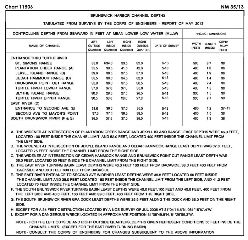
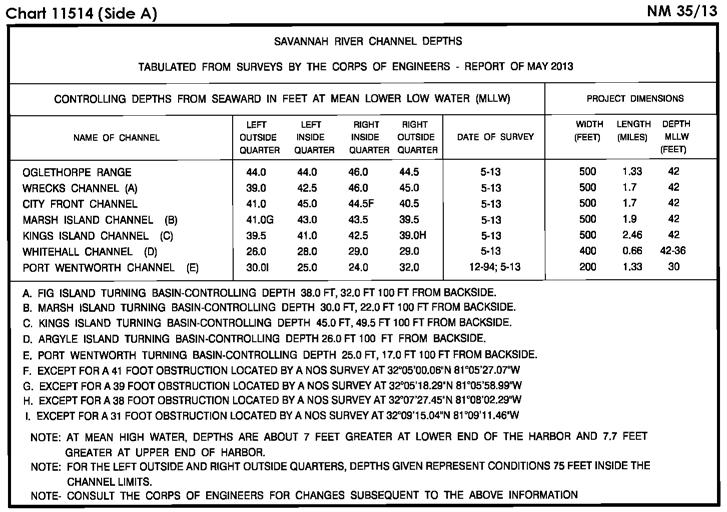
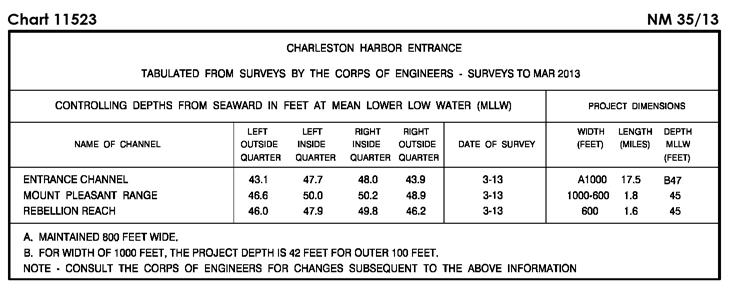
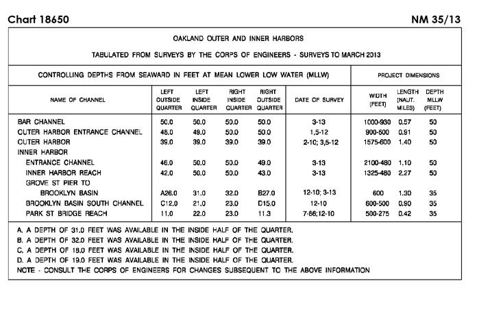
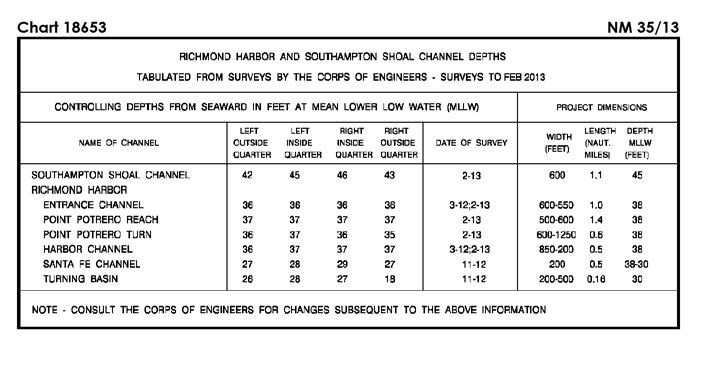
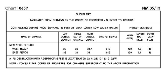
6 NM 35/13 SECTION I Ed. 10/08 LAST NM 27/13 35/13 (Side A) Add Tabulation of controlling depths from Subsection I-2 (Supersedes 27/ ) (NOS) Ed. 8/06 LAST NM 17/13 35/13 Change Visibility (range) of light 22 to 5M N W (19/13 CG7) Ed. 12/10 LAST NM 22/13 35/13 Add Tabulation of controlling depths from Subsection I-2 (Supersedes 22/ ) (NOS) Ed. 10/10 LAST NM 22/13 35/13 Add Tabulation of controlling depths from Subsection I-2 (Supersedes 22/ ) (NOS) Ed. 12/11 LAST NM 27/13 35/13 Change Legend to 41 1 / 2 FT APR N W (Supersedes 22/ ) Add Tabulation of controlling depths from Subsection I-2 (Supersedes 27/ ) (NOS) Ed. 5/18/13 NEW EDITION N35/13 (NGA) Ed. 10/12 LAST NM 27/13 35/13 Add Tabulation of controlling depths from Subsection I-2 (Supersedes 27/ ) (NOS) Ed. 6/13 LAST NM 34/13 35/13 Substitute Depth 10 feet for 15 feet N W Depth 8 feet for 18 feet N W Add Depth 8 feet N W Depth 9 feet N W Depth 9 feet N W (NOS) Ed. 4/12 LAST NM 32/13 35/13 Delete Depth 15 feet N W Depth 15 feet N W Depth 17 feet N W Substitute Depth 8 feet for 18 feet N W Add Depth 10 feet N W Depth 10 feet N W Depth 8 feet N W Depth 8 feet N W Depth 9 feet N W Depth 9 feet N W (NOS) Ed. 8/11 LAST NM 46/12 35/13 Delete Depth 15 feet N W Depth 15 feet N W Depth 14 feet N W Depth 17 feet N W Depth 18 feet N W Substitute Depth 10 feet for 15 feet N W Add Depth 10 feet N W Depth 8 feet N W Depth 8 feet N W Depth 8 feet N W Depth 9 feet N W (NOS) Depth 9 feet N W Ed. 5/12 LAST NM 25/13 35/13 Delete Depth 38 feet N W Add Depth 18 feet Rk [K14.2] N W Depth 19 feet Rk [K14.2] N W (NOS) Ed. 7/11 LAST NM 25/13 35/13 Delete Depth 38 feet N W Add Depth 18 feet Rk [K14.2] N W Depth 19 feet Rk [K14.2] N W (NOS) Ed. 2/11 LAST NM 16/13 35/13 Delete BELL from buoy N W Add Pilot station symbol [T1.1] N W (NOS; 31/13 CG1) Ed. 2/11 LAST NM 26/12 35/13 Delete Depth 38 feet N W BELL from buoy N W Substitute Depth 34 feet for 35 feet N W Depth 40 feet for 39 feet N W Add Depth 38 feet N W Depth 39 feet N W Depth 41 feet N W (NOS; 31/13 CG1) Ed. 4/12 LAST NM 28/13 35/13 Delete Depth 35 feet N W Depth 38 feet N W Depth 40 feet N W Depth 41 feet N W Substitute Depth 38 feet for 37 feet N W Depth 40 feet for 39 feet N W Depth 40 feet for 39 feet N W Depth 42 feet for 40 feet N W Add Depth 34 feet N W Depth 39 feet N W Depth 41 feet N W (NOS) Ed. 4/11 LAST NM 17/13 35/13 (Side B) Delete BELL from buoy N W Add Pilot station symbol [T1.1] N W (NOS; 31/13 CG1) Ed. 8/09 LAST NM 17/13 35/13 Add Pilot station symbol [T1.1] N W (NOS) Ed. 1/12 LAST NM 10/12 35/13 Add Submarine pipeline (sewer) [L41.1] joining N W N W N W N W N W N W N W N W N W N W N W (NOS) Ed. 12/11 LAST NM 25/13 35/13 Add Danger circle Obstn [K40] N W (31/13 CG1) I-1.2
7 SECTION I NM 35/ Ed. 6/12 LAST NM 20/13 35/13 Add Danger circle Obstn [K40] N W (31/13 CG1) Ed. 11/10 LAST NM 2/13 35/13 (Page 6) Delete Range line between N W N W Ed. 7/07 LAST NM 2/13 35/13 Change Height of range light, front to 51ft N W Relocate Range light, front from N W to N W Height of range light, rear to 91ft N W (Inset) Change Height of range light, front to 51ft N W Height of range light, rear to 91ft N W (25/13 CG9) Ed. 1/08 LAST NM 2/13 35/13 (Page 7) Change Height of range light, rear to 77ft N W Height of range light, rear to 77ft N W Range light, rear from N W to N W Change Legend to N W Add Range line extending in direction from above rear light dashed for 1600 yards, thence solid for 2470 yards (Page 7) Relocate Range light, front from N W to N W Change (Page 8) Height of range light, rear to 77ft N W Height of range light, rear to 77ft N W Range light, rear from N W to N W Note: Range line remains Change Legend to N W (Page 9) Relocate Range light, front from N W to N W Range light, rear from N W to N W and change height to 77ft Note: Range bearing unchanged Add Range line (dashed) between) N W N W (25/13 CG9) Ed. 2/04 LAST NM 51/12 35/13 Change Height of range light, rear to 77ft N W Height of range light, rear to 77ft N W (25/13 CG9) Ed. 11/03 LAST NM 25/11 35/13 Relocate Range light, front from N W to N W Range light, rear from N W to N W and change height to 77ft Note: Range bearing unchanged Range light, front from N W to N W Range light, rear from N W to N W and change height to 77ft Note: Range bearing unchanged (See 49/ ) Add Range line (dashed) between N W N W Range line (dashed) between N W N W (25/13 CG9) (Page 16) Change Height of range light, front to 51ft N W Height of range light, rear to 91ft N W (25/13 CG9) Ed. 2/05 LAST NM 2/13 35/13 Delete Range line between N W N W Relocate Range light, front from N W to N W Range light, rear from N W to N W Change Legend to N W Add Range line extending in direction from above rear light dashed for 1700 yards, thence solid for 1900 yards (25/13 CG9) Ed. 2/11 LAST NM 46/12 35/13 Change Height of range light, rear to 38ft N W (26/13 CG9) Ed. 6/06 LAST NM 36/12 35/13 Change Height of range light, rear to 38ft N W (26/13 CG9) Ed. 3/08 LAST NM 20/13 35/13 (Page 40) Change Height of range light, rear to 38ft N W (26/13 CG9) Ed. 3/11 LAST NM 33/13 35/13 Change Height of range light, rear to 50ft N W (26/13 CG9) Ed. 12/1/01 LAST NM 33/13 35/13 Change Height of range light, rear to 50ft N W (continued on next page) I-1.3
8 NM 35/13 SECTION I (Continued) (Inset Presque Isle Harbor) Change Height of range light, rear to 50ft N W (26/13 CG9) Ed. 9/05 LAST NM 33/13 35/13 Change Height of range light, rear to 50ft N W (26/13 CG9) Height of range light, rear to 83ft N W Ed. 5/09 LAST NM 31/13 35/13 (Inset Cheboygan Harbor) Change Height of range light, rear to 83ft N W (26/13 CG9) Ed. 6/03 LAST NM 42/08 35/13 (Page 2) Change Height of range light, rear to 83ft N W (26/13 CG9) Ed. 10/04 LAST NM 39/12 35/13 Relocate Range light, front from N W to N W Range light, rear from N W to N W and delete range line, dashed between old and new positions Note: Range bearing unchanged (26/13 CG9) Ed. 3/04 LAST NM 33/13 35/13 (Inset Eagle Harbor) Relocate Range light, rear from N W to N W and change height to 44ft Note: Range bearing unchanged (26/13 CG9) Ed. 8/21/93 LAST NM 17/13 35/13 Relocate Buoy 167 from N W to N W (28/13 CG11) Ed. 12/1/12 LAST NM N26/13 N35/13 Relocate Buoy 167 from N W to N W (28/13 CG11) Ed. 1/12 LAST NM 34/13 35/13 Relocate Buoy 167 from N W to N W (28/13 CG11) Ed. 6/11 LAST NM 34/13 35/13 Relocate Buoy 167 from N W to N W (28/13 CG11) Ed. 9/11 LAST NM 33/13 35/13 Relocate Buoy 14 from N W to N W (See 48/ ) Change Height of range light, rear to 56ft N W Height of range light, rear to 23ft N W Height of range light, front to 21ft N W Height of range light, front to 17ft N W (29/13 CG13) I Ed. 8/09 LAST NM 32/13 35/13 Change Light to 2 Fl R 4s 16ft 4M N W (29/13 CG13) Ed. 5/10 LAST NM 31/13 35/13 Change Height of range light, rear to 47ft N W Height of range light, front to 32ft N W (29/13 CG13) Ed. 5/07 LAST NM 32/13 35/13 Add Purple dashed line (pipeline area limit) [L40.2] between N W N W Purple dashed line (pipeline area limit) [L40.2] between N W N W Legend Pipeline Area N W (NOS) Ed. 6/13 NEW EDITION 35/13 Change Height of light A to 25ft N W (NOS) Ed. 9/09 LAST NM 33/13 35/13 Add Tabulation of controlling depths from Subsection I-2 (Supersedes 34/ ) (NOS) Ed. 2/11 LAST NM 33/13 35/13 (Page E) Add Tabulation of controlling depths from Subsection I-2 (Supersedes 45/ ) (NOS) Ed. 10/12 LAST NM 27/13 35/13 Add Tabulation of controlling depths from Subsection I-2 (Supersedes 27/ ) (NOS) Ed. 8/10 LAST NM 28/13 35/13 Add Tabulation of controlling depths from Subsection I-2 (Supersedes 45/ ) (NOS) Ed. 11/05 LAST NM 28/13 35/13 Add Tabulation of controlling depths from Subsection I-2 (See 45/ ) (NOS) Ed. 9/07 LAST NM 21/13 35/13 Add Tabulation of controlling depths from Subsection I-2 (Supersedes 45/ ) (NOS) Ed. 1/11 LAST NM 25/12 35/13 Add Tabulation of controlling depths from Subsection I-2 (Supersedes 25/ ) (NOS) Ed. 11/24/01 LAST NM 21/13 35/13 Add Tabulation of controlling depths from Subsection I-2 (Supersedes 45/ ) (NOS)
9 SECTION I NM 35/ Ed. 8/08 LAST NM 34/13 35/13 Relocate Buoy 167 from N W to N W (28/13 CG11) (Plan) Add Visibility (range) 3-2M to light N E (UKHO LL) Ed. 7/11 LAST NM 33/13 35/13 Relocate Buoy 167 from N W to N W (28/13 CG11) Ed. 12/8/12 LAST NM N33/13 N35/13 Relocate Buoy 167 from N W to N W (28/13 CG11) Ed. 10/12 LAST NM 25/13 35/13 Change Note to NOTE Kewalo Basin Entrance Sector Arcs Ed. 10/5/96 LAST NM 42/12 35/13 Change Visibility (range) of light to 8-6M N E (UKHO LL) Ed. 1/25/97 LAST NM 44/12 35/13 Change Light to Oc WRG 6s 11m 6-4M N E Note: Sectors remain unchanged (UKHO LL) Ed. 10/3/09 LAST NM 33/13 35/13 Substitute Depth 20 meters Wk [K26] for dangerous wreck (Masts) N E (Supersedes 11/ ) (2(53)13 Klaipeda) F W 33.6 to 34.0 Al WR 33.3 to 33.6 F R 32.9 to 33.3 Al WG 34.0 to 34.3 F G 34.3 to 34.7 (32/13 CG14) N W Ed. 3/13/10 LAST NM 47/12 35/13 Delete Purple outline of chart N E Add Purple outline of chart joining N E N E N E Ed. 1/2/99 LAST NM 34/13 35/13 (Plan) Change Designation of buoy to 32PM S W Designation of light to 81A S W (See 5/ ) (6(54, 55)13 Guayaquil) (NGA) Purple line between N E N E Ed. 5/11/13 NEW CHART N35/13 (NGA) Ed. 5/11/13 NEW EDITION N35/13 (NGA) Ed. 11/2/96 LAST NM 11/13 35/13 Add Chartlet, depicting changes in hydrography, topography and aids to navigation, from Subsection I S W (See 49/03, 11/ ) (20(135)12 Rio de Janeiro) Ed. 10/19/96 LAST NM 11/13 35/13 Add Chartlet, depicting changes in hydrography and topography, from Subsection I S W (See 49/03, 11/ ) (17(114)12 Rio de Janeiro) Ed. 2/5/94 LAST NM 21/13 35/13 (Plan A) Delete Plan A (NGA) Ed. 5/15/10 LAST NM 20/13 35/13 Delete Purple outline of chart N E Substitute Depth 20 meters Wk [K26] for dangerous wreck (Masts) N E (See 11/ ) Add Purple outline of chart joining N E N E N E (NGA; 2(53)13 Klaipeda) Ed. 1/28/95 LAST NM 47/11 35/13 (Plan A) Delete Light from buoy N W (8(122)13 Habana) Ed. 4/4/13 NEW EDITION N35/13 (NGA) Ed. 4/4/13 NEW EDITION N35/13 (NGA) Ed. 6/13/09 LAST NM N20/13 N35/13 (Plan A) Delete Buoy N E Relocate Buoy 18 from N E to N E Buoy 19 from N E to N E Add Buoy 16 R, conical, Fl R 3s N E Ed. 5/9/13 NEW EDITION N35/13 (NGA) (Plan B) Delete Buoy N E (INT 1650) 3Ed. 5/9/13 NEW EDITION N35/13 (NGA) Ed. 8/3/96 LAST NM 22/12 35/13 Change Light to Oc WRG 6s 11m 6-4M N E Note: Sectors remain unchanged Visibility (range) of light to 8-6M N E Add Visibility (range) 3-2M to light N E I-1.5 Relocate Buoy 19 from N E to N E Buoy 21 from N E to N E Buoy 23 from N E to N E (continued on next page)
10 NM 35/13 SECTION I (Continued) Buoy 25 from N E to N E Buoy 27 from N E to N E Buoy 35 from N E to N E (2(37, 40, 49)13 Klaipeda) Ed. 1/11/97 CHART CANCELED 35/13 (NGA) Ed. 3/30/96 LAST NM 29/13 35/13 Change Legend to Rep (2008) N E (See 29/ ) (NTM0015/2013) Ed. 12/29/12 LAST NM N29/13 N35/13 Change Legend to Rep (2008) N E (See N29/ ) (NTM0015/2013) Ed. 4/24/10 LAST NM N22/13 N35/13 (Plan A) Delete Purple dashed line and legend Port Louis Port Limit between S E S E Add Port Louis Port Limit area [N49] bound by shore and purple dashed line joining S E S E S E S E N E N E N E N E Submarine pipeline (gas) [L40.1] joining N E N E N E N E Submarine pipeline [L40.1] with legend Oil and Gas CAUTION NO 3 joining N E N E N E N E N E N E N E N E Submarine pipeline [L40.1] with legend Oil and Gas CAUTION NO 3 joining N E N E N E N E Submarine pipeline [L40.1] with legend Oil and Gas CAUTION NO 3 joining N E N E N E N E N E (See 9/ ) (17(214)12 Dehra Dun) Ed. 1/31/09 LAST NM N31/13 N35/13 Add Platform (lighted) B-172-A [L2] N E Platform (lighted) B-178-A [L2] N E Platform (lighted) B-28-A-A [L2] N E Delete (Plan B) Purple dashed line and legend Port Louis Port Limit between S E S E Designation B-179-A to platform N E Designation B-193-A-P to platform N E Designation BCP-B to platform N E Add Buoy (mooring) [Q40] RW S E Buoy (mooring) [Q40] RW S E Buoy (mooring) [Q40] RW S E Buoy (mooring) [Q40] RW S E Buoy (mooring) [Q40] RW S E Buoy (mooring) [Q40] RW S E (12(132), 13(140)13 Dehra Dun) Ed. 5/18/13 NEW EDITION N35/13 (NGA) Ed. 5/4/13 NEW EDITION N35/13 (NGA) Ed. 1/18/86 LAST NM 30/13 35/13 Change Visibility (range) of light to 10M N E (13(137)13 Dehra Dun) Ed. 12/23/06 LAST NM 34/13 35/13 Change Light to Fl(4) 30s 44m 21M Racon (M) N E (19(232)12 Dehra Dun; UKHO ARCS ) Ed. 5/2/09 LAST NM 31/13 35/13 Add Platform (lighted) B-172-A [L2] N E Platform (lighted) B-178-A [L2] N E Designation B-179-A to platform N E Designation B-193-A-P to platform N E Designation B-28-A-A to platform N E Designation B-23-A-A to platform N E Designation BCP-B to platform N E Submarine pipeline (gas) [L40.1] joining N E N E I-1.6 Submarine pipeline (gas) [L40.1] joining N E N E N E N E N E N E Submarine pipeline (gas) [L40.1] joining N E N E N E N E Submarine pipeline (gas) [L40.1] between N E N E Submarine pipeline (oil) [L40.1] joining N E N E N E N E Submarine pipeline [L40.1] with legend Oil and Gas CAUTION NO 1 joining N E N E N E N E N E N E N E N E N E Submarine pipeline [L40.1] with legend Oil and Gas CAUTION NO 1 joining N E N E N E N E (continued on next page)
11 SECTION I NM 35/ (Continued) Submarine pipeline [L40.1] with legend Oil and Gas CAUTION NO 1 joining (See N9/ ) (17(214)12 Dehra Dun; UKHO ARCS ) N E N E N E N E N E Ed. 5/3/86 LAST NM 34/13 35/13 (Panel C) Change Visibility (range) of light to 10M N E (13(137)13 Dehra Dun) Ed. 5/19/12 LAST NM N51/12 N35/13 Change Height of light to 45m N E (Plan) Relocate Light from N E to N E Change Height of light to 45m N E (12(131)13 Dehra Dun) Ed. 5/18/13 NEW EDITION N35/13 (NGA) Ed. 9/26/09 LAST NM 34/13 35/13 Add Buoy ODAS [Q58] No 2 Y, conical, Fl(5) Y 20s N E (36(551)12 Inchon) Ed. 5/27/06 LAST NM 33/13 35/13 Change Characteristic of light to Fl R 4s N E Add Buoy G, can, Fl G 4s N E Buoy G, can, Fl G 4s N E Buoy G, can, Fl G 4s N E Buoy R, can, Fl R 4s N E Buoy R, can, Fl R 4s N E (108/2009, 75/2013 Tso-ying) Ed. 4/20/13 NEW EDITION N35/13 Add Foul ground symbol [K31] N E (Previously published 30/13) (NGA) Ed. 8/18/12 LAST NM N6/13 N35/13 (Plan) Add Stranded wreck [K24] N E Stranded wreck [K24] N E (13(139)13 Dehra Dun) Ed. 3/14/09 LAST NM 51/11 35/13 Add Depth 9.9 meters enclosed by depth contour (10-meter) centered S E (7(325)13 Wollongong) Ed. 8/29/98 LAST NM 42/11 35/13 Add Depth 9.9 meters, blue tint and enclosing depth contour (10-meter) centered S E (7(325)13 Wollongong) Ed. 9/19/98 LAST NM 49/10 35/13 Add Depth 9.9 meters, blue tint and enclosing depth contour (10-meter) centered S E (7(325)13 Wollongong) Ed. 6/10/05 LAST NM N42/11 N35/13 Add Depth 9.9 meters, blue tint and enclosing depth contour (10-meter) centered S E (7(325)13 Wollongong) Ed. 1/27/12 LAST NM N25/13 N35/13 Add Depth 9.9 meters, blue tint and enclosing depth contour (10-meter) centered S E (7(325)13 Wollongong) Ed. 6/8/13 NEW EDITION N35/13 (NGA) Ed. 2/11/84 LAST NM 29/13 35/13 Change Legend to Rep (2008) N E (See 29/ ) (NTM0015/2013) Ed. 10/17/98 LAST NM 29/13 35/13 Change Legend to Rep (2008) N E (See 29/ ) (NTM0015/2013) Ed. 3/15/08 LAST NM 33/13 35/13 Add Dangerous wreck [K28] Rep (2013) (PA) N E (24(892)13 Tianjin) Ed. 10/20/12 LAST NM N33/13 N35/13 Add Dangerous wreck [K28] Rep (2013) (PA) N E (24(892)13 Tianjin) I Ed. 8/28/10 LAST NM 12/13 35/13 Add Legend AIS to light N E Purple composite line (anchoring and fishing prohibited area limit) joining N E N E N E N E Light Fl 3s 26m 7M Racon (B) N E Light Fl(2) 6s 11m 7M N E (23(688, 689), 29(903)07, 24(894)13 Tianjin; UKHO LL) Ed. 11/21/98 LAST NM 34/13 35/13 Add Light Fl 2s 32m 15M Racon (M) AIS N E Anchorage area [N12.1] bound by purple dashed line joining N E N E N E N E Pilot station symbol [T1.1] N E Light Fl 3s 26m 7M Racon (B) N E Light Fl(2) 6s 11m 7M N E Buoy YBY, pillar, double cone topmark points together, Q(9) 15s [Q130.3] N E (23(688, 689, 693), 29(903)07, 24(891)13 Tianjin; UKHO ARCS ; UKHO LL) Ed. 4/6/96 LAST NM N22/12 N35/13 Add Anchorage area [N12.1] bound by purple dashed line joining N E N E N E N E Pilot station symbol [T1.1] N E (24(891)13 Tianjin; UKHO ARCS ) Ed. 4/20/96 LAST NM N40/11 N35/13 (Panel A) Add Buoy No 1 BYB, double cone topmark bases together, Q(3) 10s [Q130.3] N E (24(891)13 Tianjin) Ed. 7/2/11 LAST NM 32/13 35/13 Add Buoy ODAS [Q58] No 2 Y, conical, Fl(5) Y 20s N E (36(551)12 Inchon) Ed. 4/29/06 LAST NM 20/12 35/13 Add Buoy ODAS [Q58] No 2 Y, conical, Fl(5) Y 20s N E (36(551)12 Inchon)
12 NM 35/13 SECTION I Ed. 9/1/12 LAST NM N1/13 N35/13 Delete Purple composite-line area and legend R.R.A. NO 344 SEE NOTE in vicinity N E Depth 3.6 meters, blue tint and enclosing depth contour (5-meter) centered N E (28(4327)13 St. Petersburg) Add Purple composite-line area and legend R.R.A. NO 345 SEE NOTE in vicinity N E Submarine cable [L30.1] joining N E N E N E N E N E N E Marine farm area [K48.1] bound by shore and dashed line joining N E N E N E N E N E Marine farm symbol [K48.2] N E Marine farm symbol [K48.2] N E Marine farm symbol [K48.2] N E Marine farm symbol [K48.2] N E Marine farm symbol [K48.2] N E Marine farm area [K48.1] bound by dashed line joining N E N E N E N E N E N E Marine farm area [K48.1] bound by dashed line joining N E N E N E N E Ed. 12/2/95 LAST NM 19/11 35/13 Add Depth 5.6 meters N E Depth 3.6 meters N E (28(4327)13 St. Petersburg) Ed. 2/12/11 LAST NM 28/13 35/13 Add Buoy ODAS [Q58] No 2 Y, conical, Fl(5) Y 20s N E (36(551)12 Inchon) (INT 535) 1Ed. 4/17/08 LAST NM N32/13 N35/13 Add Buoy ODAS [Q58] No 2 Y, conical, Fl(5) Y 20s N E (36(551)12 Inchon) Ed. 4/10/10 LAST NM N20/12 N35/13 Add Buoy ODAS [Q58] No 2 Y, conical, Fl(5) Y 20s N E (36(551)12 Inchon) Marine farm area [K48.1] bound by dashed line joining N E N E N E N E N E (49( )11, 28(4338)13 St. Petersburg) Ed. 6/19/82 LAST NM 13/13 35/13 Add Foul ground symbol [K31] N E Depth 6 meters N E Depth 6 meters N E Submarine cable [L30.1] joining N E N E N E N E N E N E PROHIBITED AREA NO 110 [N2.2] bound by purple dashed line joining N E N E N E N E Marine Farm area [K48.1] bound by dashed line joining N E N E N E N E N E Marine Farm area [K48.1] bound by shore and dashed line joining N E N E N E N E (49(6419, 6420)11, 38(5660)12, 11(1637), 25(3789), 28(4338)13 St. Petersburg) Ed. 7/22/89 LAST NM 32/05 35/13 Add Depth 5.6 meters N E I-1.8

13 SECTION I NM 35/13 I-2.1

14 SECTION I NM 35/13 I-2.2

15 SECTION I NM 35/13 I-2.3

16 SECTION I NM 35/13 I-2.4

17 SECTION I NM 35/13 I-2.5

18 SECTION I NM 35/13 I-2.6

19 SECTION I NM 35/13 I-2.7

20 SECTION I NM 35/13 I-2.8

21 SECTION I NM 35/13 I-2.9

22 SECTION I NM 35/13 I-2.10

23 SECTION I NM 35/13 I-2.11
24 SECTION I NM 35/13 CHARTS AFFECTED BY NOTICE TO MARINERS NM 1/13 THROUGH NM 35/13 Note: N indicates Not For Sale; P indicates Preliminary; T indicates Temporary; * indicates New Edition/New Chart; ** indicates Chart Canceled Chart Ed. Notice to Mariners / / / ,34/ ,34/ / ,18/ / / ,31/ / / / ,9,21/ / / ,34/ ,21,30/ ,3,7,12,17,28,32,34/ ,12,17,34/ ,31/ / ,13,34/ / ,11,17,28,32,34/ / / / ,13/ / / / ,35/ / / / A 21*,35/ A 1,2,3,5,9,14,20,27,35/ A 23*,25,27,30,32,33,35/ A 5,13,14,17,21/ ,14,21,27,32,33/ ,14,27,32,33/ ,8/ ,14,23,30/ N1,N5,N6/ ,13,14,17,21/ ,26/ ,26/ N6,N13,N26/ / ,5,6,13,26/ N1,N6,N26/ ,13,33/ ,5,6,13,26/ ,9/ / ,5,9/ ,5,21/ N6,N13,N26/ / N5/ ,33/ ,2,6,13,14,17,26,27/ ,2,14,26/ *,26,30/ ,2,14,33,35/ *,26/ *,26,33,35/ ,26,33,35/ *,35/ *,21,25,26,27/ *,26,27,33/ *,27,30,32,33,35/ *,25,26/ *,13,14,18,26/ ,26/ ,13,18,20,25,26/ / ,20,26,32/ *,27,33/ /13* ,3,4,6,9,13,15,18,27, 35/ ,5,13/ ,27/ ,27/ ,3,5,6,9,13,15,17,21/13 Chart Ed. Notice to Mariners ,2,3,9,15,21,27,33/ ,6,20,32,33/ ,2,3,5,9,14,20,27,35/ /13* N1,N2,N3,N5,N9,N14, N20,N27,N35/ *,20,27,30/ *,20,27/ ,3,5,9,14,20,27,30,32, 33,35/ / / ,13,17,20,27/ / ,30,33/ ,14,20,27,30,33/ ,27,30/ / /13* /13* /13* /13* / /13* / /13* *,26/ /13* /13* /13* /13* *,32/ ,17,32,35/ /13* /13* *,35/ / *,32/ / / /13* / /13* /13* *,27,29,35/ *,16,35/ / *,27,29,35/ ,11,16,29/ / ,30/ ,5,8,11,16,30/ / / ,8,15,30/ ,14,30/ *,30/ *,30/ ,5/ ,11,16,30/ ,15,16,29/ ,15,16,17/ ,16/ / ,15/ N5,N15/ ,15,29/ N15,N17/ / / / N8,N28,N29/ *,27,29/ N8,N15/ ,11,26,32/ /13* N5/ / ,11/ ,11/ ,6,8,17,26,29,32,35/ ,29,32/ ,32/ / N8,N16/ N6,N8,N16,N35/ N8,N11,N26,N32/13 Chart I-3.1 Ed. Notice to Mariners *,35/ / ,11,16,26,27,32,35/ ,11,16,27,29,35/ ,26/ ,26,32/ / *,32,35/ / ,11,16,27,35/ ,35/ ,17/ / ,22,35/ ,17,22,35/ ,8,11,16,17,22,27,35/ N35/13* ,16,25/ *,6,8,27,35/ / *,28/ *,32/ /13* *,32/ / /13* ,21,24,28,32/ /13* ,7,8,11,17,23,24,31, 34/ N1,N7,N8,N11,N17, N23,N24,N31,N34/ *,17/ ,31/ *,22/ *,31/ ,7,9,24,31/ ,4,6,11,17/ *,34/ / ,17,20,27/ *,27,30/ ,27/ ,7,8,20/ ,20/ / /13* / ,11,27/ / / ,17,27/ ,17,27,32/ / /13* /13* *,34/ / ,30/ / ,30/ *,27/ ,25,27/ *,27/ / / /13* ,9,12,27/ / ,27/ *,12,14,27,32/ ,7,9,11,12,20,27/ ,14,32/ *,26/ ,10,26/ ,10,26/ / ,8,11,12,14,21,23,24,25, 30/ N3,N8,N11,N12,N14, N21,N23,N24,N25, N30/ ,26/ ,9,14,25,34/ ,8,9,13,25/ ,9,13/ ,18/13 Chart Ed. Notice to Mariners ,14,23,24,25/ *,12,14,23,34/ ,12,23,34/ *,35/ ,13,18,25,27,28,29,32, 35/ ,28/ ,28/ *,13,19,28,32/ ,25,27,28,32/ ,27,29,32/ *,32/ *,29/ /13* / /13* *,22,27/ / / ,11,13,17,18,25,35/ ,35/ / ,18/ ,4,13,18/ / /13* /13* / ,18/ ,11,16,18,21/ ,11/ / / ,8,11,14,16,17,23,24,25, 34/ ,8,11,14,16,20,32/ ,11,16,20,32/ / N11/ /13* ,18,21,25,30/ ,21,25/ / / / ,30/ ,30/ / ,16,17,19,32/ ,32/ *,33/ ,19,33/ / / ,20,21/ / / / /13* / ,27/ ,16,20,32/ N8,N16,N20,N32/ ,16,35/ / ,25,28,35/ ,16,17,35/ ,11/ ,11/ ,17/ ,35/ / /13* /13* ,20,32/ / / /13* / / ,25,35/ ,35/ ,25/ /13* /13* /13* /13*
25 NM 35/13 SECTION I CHARTS AFFECTED BY NOTICE TO MARINERS NM 1/13 THROUGH NM 35/13 Note: N indicates Not For Sale; P indicates Preliminary; T indicates Temporary; * indicates New Edition/New Chart; ** indicates Chart Canceled Chart Ed. Notice to Mariners *,17/ *,17/ /13* ,23/ / / ,31/ / ,31/ / / / ,2,33/ ,33/ /13* ,2,35/ /13* *,15,33/ /13* / / ,2,35/ / / ,2,35/ ,35/ / / ,35/ / ,33/ / / ,33,35/ /13* ,33,35/ ,35/ ,35/ / / ,20,29,34/ ,14,31,34/ *,29,34/ / / ,34/ / ,31,34/ / / / / / /13* / ,34/ / / *,14/ ,30/ / ,34/ ,33/ ,35/ / / ,33/ / N33/ N33/ / ,21/ ,30,33/ ,33/ / / /13* ,21/ /13* /13* ,26/ / / / / / /13 Chart Ed. Notice to Mariners / / / ,8/ *,8/ *,8/ / / / / / / / ,29,34/ ,34/ / ,34/ / / / ,27/ *,6/ /13* /13* /13* / / / / /13* /13* /13* /13* /13* / N4/ N4/ /13* / N4/ N2,N27/ ,7,14,16,17,35/ N12*,N14,N16,N17, N20,N26,N35/ ,20,24,27,31/ N12*,N17,N32,N34/ N13/13* ,20,27,28,31,34/ N2,N20,N28,N31, N34/ N12*,N33,N34/ ,18,27,28,31,33,34/ N14/ ,7,11,12,14,16,17,20,28, 32,34,35/ ,7,11,12,14,16,17,20,26, 27,32,33,34,35/ ,6,24,27,33/ *,33/ ,20,24,26,27,30,32, 33/ / *,33/ / ,33/ / ,20,27,30,32/ ,27,30,32/ ,24,25,30/ / / ,24,25,30/ *,20,24,30/ /13* N2/ / *,27/ / ,27,32/ / ,32/ ,24,25,30/ *,27/ / *,27,30/ ,20,24,32,33/ ,24,32,33,35/13 Chart I-3.2 Ed. Notice to Mariners ,19,20,24/ ,6,20,31,32,35/ ,26,31,35/ ,31/ ,4,18,20,31/ ,4,18,31/ / ,18,19,20,31/ / / ,24/ / ,31/ ,32/ / ,8,10,19,32,35/ ,10,24,26,31/ ,26,33/ ,18,34/ / ,19/ ,20,28/ ,27/ / *,33/ /13* / /13* ,9,11,12,16,21,31,33, 35/ ,5,9,11,12,16,17,21,27, 28,31,33,35/ *,18,21,27,35/ / / ,28,35/ ,35/ ,35/ / / ,28/ / / ,35/ *,34/ / ,22,32/ *,27,32/ ,7,14,17,18,22,27,34, 35/ ,14,17,22,30,31/ ,33/ /13* / / N3/ ,6,11,12,16,20,22,23,25, 26,27,28,33,35/ N13*,N16,N23,N27, N28/ ,22,26,28,33/ ,12,19,20,28,31,32/ ,19,20,28/ / / / / N12*,N14,N16,N20, N26,N27,N28,N33, N35/ N12/ ,12/ ,12/ ,11,12,16,23,28/ ,11,16,23,28/ N12*,N16,N23,N28/ N13*,N27/ ,11,23/ ,9,11,23/ ,9,28/ N12/ N9,N14,N30/ ,14,30/ ,14/ ,14/ ,14,30/ ,14,30/13 Chart Ed. Notice to Mariners / / / N9,N14,N17,N19, N30/ ,14,17,19,30/ / / *,25,27,32/ ,5/ ,32/ / *,19,25,35/ *,19,25/ /13* ,7/ ,7/ N6/13* ,9,11,17,19/ / / / ,16,23/ / / N4/ / / / / / ,5,6,7,8,15/ ,5,6,10/ ,9/ ,4,17/ ,17/ ,11,15,16/ ,11,12,19/ ,4,7,12,13,14,19,20,21, 24/ ,11/ ,4,7,11,12,13,14,19,20, 21,24/ ,8,11/ ,13/ / ,13/ / / ,7,8,15,30/ / N11/13* N8/13* ,8,14/ / ,5,6,7,11,30/ ,6,7,34,35/ / / ,4,5,6,9/ ,9,31/ ,4,9,31/ ,6,33/ ,6/ ,10/ / / ,6/ N10/13* N7/13* / / / / / / / / / / / / ,18/ ,26/ N3,N30/ / /13
26 SECTION I NM 35/13 CHARTS AFFECTED BY NOTICE TO MARINERS NM 1/13 THROUGH NM 35/13 Note: N indicates Not For Sale; P indicates Preliminary; T indicates Temporary; * indicates New Edition/New Chart; ** indicates Chart Canceled Chart Ed. Notice to Mariners / / N9/ N4/13* N4/13* N9/ N9/ ,17/ / ,17/ / / ,27/ / / N6/ N6/ / / / ,4,17/ ,17/ ,5/ ,17,22/ ,21,24/ N3,N19/ / ,5,22/ ,9,25/ ,25,30/ N4/13* N5,N9/ N8/13* N5,N9,N25/ N5,N9,N25/ N9,N25/ N30/13* ,12/ N5/13* ,5,19,22/ N12/13* / / / ,27/ N7*,N20,N26,N27/ ,24/ N5,N10,N11,N15,N16, N27/ N9,N11,N16/ N12*,N26,N27/ N6,N8,N20,N26/ N14,N15,N26,N32/ ,20,24/ N16/ / / / / / N35/13* N11/13* / / N19/ / N8,N13,N31/ N8,N11,N13/ ,35/ ,35/ / / / N12/13* N6/ / / ,8/ / / / / / / / ,29/ ,21/13 Chart Ed. Notice to Mariners ,27,32/ N7,N32/ N7,N32/ / / ,8/ / / / ,18/ ,7/ N11/13* ,15/ ,15/ ,30/ / ,7,17,18,24,25,27/ ,30/ ,25,27/ / ,14,27,30/ ,8,33/ ,17/ ,8,33/ ,17,18,24,25/ ,4,8,10,17,20,24,25/ ,4,5,10,20,25/ ,8,10/ ,3,4,5,8,10,20,25/ ,24/ ,18/ / / ,25,27/ ,34/ N17,N34/ ,34/ ,27/ / / / / ,19/ ,19/ ,34/ / / / / ,34/ *,17/ ,17/ /13* / ,17/ / / / / / / *,13,29/ / ,17/ / *,17/ ,15/ ,16/ / / N32/ N17/ ,23/ ,15/ / / / / / N34/13* N11/ / / ,33/ ,3,15/ / /13 Chart I-3.3 Ed. Notice to Mariners ,5/ / ,15,30/ / / / / / / / ,31/ / / ,21/ / / ,31/ / / ,32/ / ,17/ ,34/ / / / ,34/ / ,32/ ,13,15/ / / / / / N31/13* / / / / / ,22/ / / / / / / / ,33/ N33/ N8/13* N35/13* N9/ N9/ N9,N21,N32/ N9,N21,N32/ N8/13* N11/13* N9/13* N34/13* N35/13* N11/13* N11/13* N25/13* N25/13* N10/13* N8/13* N27/13* N25/13* N25/13* N18/13* N17/13* N35/13* N8/13* N9/ N8/13* N9/ N9,N32/ N9,N21,N32/ N10/13* N21/ N21/ N17/13* N21/ N21,N32/ N21/13 Chart Ed. Notice to Mariners N9/13* N11/13* N24/13* N34/13* N35/13* N10/13* N11/13* N8/13* N9/13* N7*,N8,N31,N33/ N34/13* N25*,N27/ N22/13* ,8,33/ N27/ N34/13* N25/13* N31/13* N27/13* N18/13* N8/13* N11/13* N10/13* N33/ N9/13* ,8,23,33/ N6,N21/ / N1,N5,N11,N22/ N21/ N4,N32/ N26*,N31,N33/ ,5,9,23/ / ,10/ ,6,8,9,10,11,12,13/ N6,N8,N10,N11,N12, N21,N22/ ,9,11,31/ N9*,N10,N22/ N25/13* N16/13* N18/13* N16/13* N5,N8,N10,N11,N12, N13/ N8,N12/ N10,N13/ ,10/ N21,N22/ N5,N24,N32/ N4/ N4,N5,N6,N8,N11,N21, N33/ N6,N10,N21,N23,N27, N29,N30,N34/ N1,N6,N13,N22,N29, N34/ N9,N23,N33/ N1/13* N15/13* N15/13* N1/13* N6/13* N9,N13/ ,13/ / / / / / / /13* N15/13* / / N25/13* / N9/13* N22/13* / / / / / / ,33/13
27 NM 35/13 SECTION I CHARTS AFFECTED BY NOTICE TO MARINERS NM 1/13 THROUGH NM 35/13 Note: N indicates Not For Sale; P indicates Preliminary; T indicates Temporary; * indicates New Edition/New Chart; ** indicates Chart Canceled Chart Ed. Notice to Mariners / / N24/13* ,31/ / N5/ / N30/13* ,2/ / / ,11,33,35/ / N2/ N18*,N28/ N8,N10/ / / N12/ N1,N8,N12/ ,10,11,13/ ,11,13/ ,11,12/ / / ,5/ / / / N25/13* N26/13* / / N27/13* N1/13* N8/13* N7/ / N32/ N32/ N7/ N35/13* N6*,N19,N24,N31/ ,35/ ,20,33/ N5,N10,N20/ / / ,11,20,35/ N5/ N5,N6/ N11,N20,N35/ /13** N8,N11,N12,N13, N25/ N8,N9,N10/ N8/ / / N33/ N25,N33/ / / / N1/13* / / / N25/13* N4/13* N25/13* N34/13* N21/ / N21/ / ,30/ / N30/13* N27/13* / / N30/13* N18/13* N18/ N4/13* /13 Chart Ed. Notice to Mariners N5/ / / / N21/13* N4/13* / / / / / N11/13* N18/ N7/13* N12/13* / / / / / ,6/ / / / / / / / ,4/ N2/ / / ,5/ / / / / / / N11/13* / / N12/13* ,5,6/ ,6/ ,6/ / / N12/13* N6/13* / / ,27/ / ,35/ N15*,N29,N35/ / ,23,30/ N1,N3,N6/ ,3/ / N24/13* / / ,24,27/ ,23,24,26/ ,26/ ,27/ N9,N23,N25,N28/ ,26,28/ ,4,8/ / N23,N28/ ,26/ ,23,25,26,30/ / N25,N27/ ,25/ / / N4/ ,8,24,25,27,31/ ,27/ ,30/ ,23,24,25,27,31/ ,23,25,27,30/ /13 Chart I-3.4 Ed. Notice to Mariners ,7/ N5/13* N5/13* N5/13* ,8/ ,34/ / N8/ / / ,14,15,16,19/ ,17,19/ N26/13* N1/13* / ,13,14,15,16/ N13/ ,14,16,19,26/ N14/ ,19/ ,17/ ,15,16/ ,14,15,16,17/ N15,N19,N26,N33/ N11,N19,N26,N33/ N15,N19/ N15/ ,17/ / / ,16,17/ ,17,19/ N16,N19,N26/ N11,N14,N16,N17/ N11,N14/ N14/ / N18/ / ,15/ N15/ N26/ / / / / / N21/ N21/ N22,N35/ ,10,13/ / / ,11,12,15,16,18,21/ N6,N11,N12,N15,N16, N18,N21/ ,21/ N18*,N21/ / / / / N26/13* ,10,13/ N6/13* / / N7/13* N26/13* / / / / N6*,N17,N27,N28/ / ,28/ / ,23,24,27,28,30/ ,18,27,28/ N11,N18,N27,N28/ / ,25,27/ ,16/ / N35/13* N1/13* ,10/13 Chart Ed. Notice to Mariners / / / N21/13* ,10,15,16,21/ ,11,20,22,31,34/ ,11,15,34/ N1/13* / ,11,12,14/ / / N27/13* ,16/ ,10,15,21/ / N35/13* N12/13* N21/ N31/13* N8,N15,N34/ N5/13* ,22/ / N5/13* N6/13* N20/ ,8,11,12,15,16,18,21/ ,11,12,20,21/ N6/ N20/ ,10,11,18/ N6,N10,N11,N18/ ,10,15,16,21/ N6,N10,N15,N16, N21/ ,8,11,12,14,21,22/ N6,N8,N11,N12,N14, N21/ ,18,20,21,23,24/ N15,N18,N20,N21,N23, N24/ ,8,11,21,22/ ,21/ ,17,23/ ,16,17,20/ N11,N17,N20/ / ,27,34/ ,27,28,34/ ,22,29,30,35/ ,28/ / / / ,21/ ,22,23,34/ ,27,34/ / / ,27/ ,34,35/ ,27,31,35/ ,27,28,34/ N24/13* / N9,N22,N27,N31, N35/ N22,N27,N31/ N22,N31/ / N27/ N27/ / ,28/ ,27,28,29,34,35/ ,34/ N28/ N28,N34/ ,34/ / ,23/ N23/ ,22,27/ ,28,34/ N23,N28/ N35/13
28 SECTION I NM 35/13 CHARTS AFFECTED BY NOTICE TO MARINERS NM 1/13 THROUGH NM 35/13 Note: N indicates Not For Sale; P indicates Preliminary; T indicates Temporary; * indicates New Edition/New Chart; ** indicates Chart Canceled Chart Ed. Notice to Mariners / / / N6*,N35/ / / / N27/ ,33/ N26/13* ,16,29,30,31/ / / N22/ / / N28,N32/ N28,N29,N32/ N29,N32/ N34/13* ,6/ N26/13* N29/ N29/ N4/ N31/13* N4,N6,N29/ / ,6,16,29/ N6/ N6/ / / / N7/13* / N13/ / / / ,29/ / / / / / N15/13* / / / / / / / ,7,9,11/ ,28/ ,4,13/ / / N23/13* N24/13* N5,N6,N8,N9,N11/ N11/ N8,N9,N11/ N8,N9,N11/ / / N4/ ,9/ / N14/ N14/ / N26/13* N14/ N14,N15/ N15/ ,15/ N26/13* / / / N35/ N2,N3,N4/ N25*,N35/ N2,N3,N4,N14/ N10,N11,N13/13 Chart Ed. Notice to Mariners N4,N13/ N13/ N2,N3,N4,N14/ N2,N3,N4,N14/ ,4/ N3/ N4,N20/ N20/ ,7,8,9,11/ N3/ N25/13* N24/13* / ,9,11,13/ N3/ N5,N8,N9,N11,N13/ N5,N6,N8,N9,N11, N14/ N14/ N14/ N5,N6,N7,N8,N9, N11/ ,14,15/ / N26/13* / / ,15/ / / / / / / ,33/ ,28/ ,31/ / / / / N32/ / / / *,18/ /13* /13* /13* /13* /13* / / / N12/13* / / ,6,13/ ,11,33/ / / / ,8/ / / N34/13* / N3,N4,N5,N8/ N5,N8/ ,8/ N34/13* N35/13* ,5,14/ ,14/ ,29,35/ / ,14/ / / N10/13* / / ,29,35/ / / ,18,28,33,35/ ,29/13 Chart I-3.5 Ed. Notice to Mariners / ,12,14,24,30/ / ,9,10/ ,21/ ,9,12,18/ N24*,N25,N28,N33/ / / / N22/ / N10*,N22/ / N22/ / / / / N12/13* N8/13* N22/13* N24/13* N8/13* N12/ N34/13* N6/13* ,12,18/ / ,9,10/ N9/ ,9/ N8,N9,N10/ ,9,10/ N31/13* N8,N9/ ,18,28,29/ N6,N9,N13,N27,N28, N29,N30,N32,N33/ ,33/ N6*,N9,N13,N18,N28, N29,N33,N35/ N5,N9,N13,N18,N26, N28/ N13,N18,N26,N28/ N5,N26,N27/ N35/13* ,30,33/ ,12,30,31/ ,14,16,25,28,32,34, 35/ ,16,19,20,23/ N1/13* ,30,33/ ,13/ / / / ,30,32,33,35/ N35/13* / ,11,31/ N33/ N28/ N28/ ,9,11,25,28/ ,14,25,26/ ,14/ ,35/ ,34/ / ,9,10,12,13,14,15,16,17, 34,35/ ,9,10,11,16,34/ N35/ N35/ N8/ N8,N33/ N8/ ,10/ N1*,N16/ N1/13* N15/ ,8,12,13/ N7,N8,N10,N11,N12, N13/ /13 Chart Ed. Notice to Mariners N15,N20/ N15,N20/ N15,N19/ N11/13* / / N17,N19/ N18/ N16/ N17*,N19,N23,N27, N34/ N23,N25,N30,N34/ N19,N20,N21,N22,N23, N24,N25,N26,N27,N29, N30,N31,N33,N34/ N22,N23,N24,N28,N29, N30/ N6*,N19,N20,N21,N22, N26,N28,N32,N33/ N11/13* N30/ N26,N27,N30,N31/ N26,N27,N31/ ,28,32,34/ N28,N34/ N27/ N32,N34/ N22/ N23,N28/ N28/ ,25,32,35/ N25/ N22,N25,N28/ / / N1/13* ,25,28,33/ N23,N25,N27,N28,N31, N32,N34/ N32,N33/ N28/ N32,N33/ N29/ N27/ N27/ N29,N33/ N17/13* N10,N11/ N5/13** /13** N5/13* N1/13* / ,8/ ,21/ N1*,N35/ ,35/ / / / / / ,11/ ,25,28,35/ N21,N22,N32,N35/ / N16/13* N1/13* N16/13* / N30/13* / /13** N30/13* /13** /13** N27/13* / / ,31/ ,28/ N16/ / / ,28,31/ N10/13* ,11/13
29 NM 35/13 SECTION I CHARTS AFFECTED BY NOTICE TO MARINERS NM 1/13 THROUGH NM 35/13 Note: N indicates Not For Sale; P indicates Preliminary; T indicates Temporary; * indicates New Edition/New Chart; ** indicates Chart Canceled Chart Ed. Notice to Mariners N12/13* ,31/ / / N13/13** N12/ N21/13** N25/13** N25/13* N16/ N4/ N12/ N5/ N19,N20,N21,N22,N23, N24,N25,N27,N29,N30, N31,N33,N34/ N20/13* N23,N28/ N29/ N19,N20,N23,N24,N25, N27,N30,N31/ N5/13* N25/13* N35/ N22,N23,N24,N27,N29, N30/ N11/ N5/ N25/13** N33,N34/ N19,N32/ N28,N32,N33/ N11/ N25,N28,N32/ N25/13* N29/ N27/ N33,N34/ N17*,N19,N20,N21, N26,N28,N32,N33/ N25/13* N13*,N23/ N17/ N25/13** N23,N25,N27,N28,N31, N32,N34/ N17/13* N21*,N25/ N13/13* N25/13* N25/13* N13/13** I-3.6
30 SECTION II NM 35/13 NGA/DLIS CATALOG CORRECTIONS Note: Underlining indicates that column in which a correction has been made or new information added. Edition NGA Ref. (National Stk. ) Title Scale = 1: Date Price Category NTM REGION 1 11XHA11428 ( ) St. Lucie Inlet to Fort Myers and Lake Okeechobee Various 36 6/13 NOS 35/13 11AOA11525 ( ) Cape Hatteras to Cape Fear- Cherry Point Fleet Operating Areas 436, /13 DS 35/13 18AHA18649 ( ) Entrance to San Francisco Bay 40, /13 NOS 35/13 24XHA24154 ( ) REGION 2 Port of Angra Dos Reis and Approaches S W S W S W S W S W S W S W S W 20, /13 DS 35/13 REGION 3 35ACO35013 ( ) 35ACO35056 ( ) 35AHA35097 ( ) 36BHA36034 (INT 1650) ( ) UKHO 1409, Buckie to Arbroath 200, /13 UKHO 35/13 UKHO 1942, Fair Isle to Wick 200, /13 UKHO 35/13 UKHO 2390, Sound of Mull 25, /13 UKHO 35/13 Inset: Continuation of Sound of Mull 25,000 Plan: Loch Aline 10,000 UKHO 3274, Milford Haven 12, /13 UKHO 35/13 REGION 4 44BHA44364 ( ) Kotka N E N E 10, /13 DS 35/13 44AHA44367 ( ) Approaches to Kotka and Hamina 50, /94 A 35/13 Plans A: Canceled B: Hamina Harbor 20,000 44ACO44461 ( ) Canceled Replaced by charts announced in NM 19/10 and announced in NM 44/10 35/13 REGION 6 62AHA62393 ( ) 62AHA62442 ( ) Approaches to Bandar 'Abbas 100, /13 DS 35/13 Khowr-e Musa 25, /13 DS 35/13 Inset: Bandar-e Mahshahr 15,000 REGION 9 91AHA91360 ( ) 93BHA93778 ( ) Ticao Pass to Sibuyan Sea 100, /13 DS 35/13 Approaches to Zhanjiang 9 5/13 DS 35/13 Panels A: Approaches to Zhanjiang 25,000 B: Continuation 50,000 II-1.1
31 NM 35/13 SECTION II NGA/DLIS CATALOG CORRECTIONS Note: Underlining indicates that column in which a correction has been made or new information added. Edition NGA Ref. (National Stk. ) Title Scale = 1: Date Price Category NTM 94AHA94083 ( ) Approaches to Kao-hsiung 30, /13 DS 35/13 MISCELLANEOUS CHARTS AND PUBLICATIONS CDPUBQTLY ( ) LLPUB115 ( ) Pub 148, Caribbean Sea-Volume II (Enroute), /13 Norway, Iceland and Arctic Ocean /13 Price Categories effective 1 October 2012 A E G 7.00 D F H CHS Canadian Hydrographic Service DS Distribution Limited GPO Government Printing Office NOS National Ocean Service UKHO United Kingdom Hydrographic Office DHO Danish Hydrographic Office AHS Australian Hydrographic Service JCG Japan Coast Guard * Not for sale or reproduction outside U.S.A. To locate the nearest FAA Sales Agents in your area, go to: Note: New editions cancel former editions. They include corrections published in the Notice to Mariners prior to the effective date of the new editions and/or important corrections from other sources. Mariners are warned against the use of obsolete charts and publications as new editions contain information essential to safe navigation; however, such new editions are not valid until their availability is announced in the weekly Notice to Mariners. DoD users and DoD contractors may direct questions concerning the availability and distribution of announced hardcopy charts to the Defense Logistics Agency (DLA) at or ; DSN ; Fax Civilian users can obtain information about ordering NGA paper charts at: II-1.2
32 SECTION II NM 35/13 NAVIGATION PUBLICATIONS NGA LIST OF LIGHTS CORRECTIONS PUB 115 Ed 2013 NEW EDITION (NGA) 35/13 SAILING DIRECTIONS CORRECTIONS PUB Ed 2013 NEW EDITION (NGA) 35/13 COAST PILOT CORRECTIONS COAST PILOT 2 42 Ed AUG 2013 LAST NM 33/13 Chapter 7 Paragraph 274; read: (274) A railroad causeway with two fixed spans crosses Stonington Harbor 0.4 mile above Stonington; the east span has a clearance of 5 feet and the west span has a clearance of 4 feet. Overhead power cables at the openings have clearances of 41 feet. (L ) 35/13 COAST PILOT 6 43 Ed AUG 2013 LAST NM 33/13 Chapter 5 Paragraph 153; read: (153) The O Rorke bridge, 1.25 miles above the pierheads, has a bascule span with a clearance of 41 feet (45 feet at center). (See 33 CFR through and , chapter 2, for drawbridge regulations.) Overhead power cables crossing the river 2.8 miles above the pier heads have a clearance of 141 feet. Above the limit of the Federal project, a pipeline bridge, about 5.1 miles above the pier heads, has a fixed span with a clearance of 86 feet. The Ridge Road (U.S. Route 104) bridge, about 5.5 miles above the pier heads, has a fixed span with a clearance of 160 feet. The Driving Park Avenue bridge, 6.4 miles above the pier heads, has fixed span with unknown clearance. (L ) 35/13 Chapter 11 Paragraph ; insert after: New table titled Structures across Indiana Harbor Canal from back of this subsection. (L ) 35/13 Chapter 11 Paragraph ; insert after: New table titled Structures across Milwaukee, Menomonee and Kinnickinnic Rivers from back of this Subsection. (L ) 35/13 II-2.1

33 SECTION II NM 35/13 Chapter 11 COAST PILOT 6 II-2.2

34 SECTION II NM 35/13 Chapter 11 II-2.3 COAST PILOT 6
35 SECTION II CORRECTIONS TO C. G. LIGHT LIST, VOLUME I ATLANTIC COAST, 2013 (1) (2) Name and Location (3) Position (4) Characteristic (5) Height (6) Range (7) Structure (8) Remarks Buoy N W Green can Buoy N W Green can Lighted Buoy N W Q R 3 Red Buoy N W Green can Buoy N W Red nun Lighted Buoy N W Lighted Buoy N W Fl G 4s 4 Green. Replaced by can when endangered by ice. Q R 2 Red. Replaced by nun when endangered by ice. CORRECTIONS TO C. G. LIGHT LIST, VOLUME II ATLANTIC COAST, 2013 (1) (2) Name and Location (3) Position (4) Characteristic (5) Height (6) Range (7) Structure (8) Remarks Buoy N W Buoy N W 7295 RAPPAHANNOCK SHOAL CHANNEL SOUTH RANGE REAR LIGHT 7,399 yards from front light N W Red nun. Note: Asterisks (*) indicate that column(s) in which a correction has been made or new information added. Denotes a new entry when preceding the station number. II-3.1 Maintained from May 1 to Nov. 15. Green can. Maintained from May 1 to Nov. 15. F W (Night) F W (Day) On skeleton tower on caisson. Lighted throughout 24 hours. DAY: Visible on range line only. NIGHT: Visible 0.9 either side of range line. * Warning Daybeacon C N W NW on pile worded DANGER SHOAL. * * * * Lighted Data Buoy T N W * Lighted Data Buoy T N W Buoy N W Fl Y 4s Yellow. Maintained from Mar. 15 to Dec. 15. Maintained by NOAA. 35/13 Fl Y 4s Yellow. Maintained from Mar. 15 to Dec. 15. Maintained by NOAA. 35/13 Red nun Lighted Buoy 10B N W Fl R 2.5s 4 Red Channel Buoy 11AA N W Green can.
36 SECTION II CORRECTIONS TO C. G. LIGHT LIST, VOLUME II ATLANTIC COAST, 2013 (1) (2) Name and Location (3) Position (4) Characteristic (5) Height (6) Range (7) Structure (8) Remarks Channel Lighted Buoy 11B N W Fl G 2.5s 4 Green Channel Buoy N W Red nun Channel Lighted Buoy 12A N W Fl R 2.5s 3 Red Channel Buoy 12C N W Red nun Channel Buoy 19A N W Green can. CORRECTIONS TO C. G. LIGHT LIST, VOLUME III ATLANTIC AND GULF COAST, 2013 (1) (2) Name and Location (3) Position (4) Characteristic (5) Height (6) Range (7) Structure (8) Remarks 1005 BIG PINE SHOAL LIGHT 22 On seaward edge of reef USF COMPS Lighted Buoy C USF COMPS Lighted Buoy C USF COMPS Lighted Buoy C USF COMPS Lighted Buoy C USF COMPS Lighted Buoy C USF COMPS Lighted Buoy C USF COMPS Lighted Buoy C NEWFOUND HARBOR KEYS LIGHT N W N W N W N W N W N W N W N W N W Q R 18 5 TR on dolphin. Fl Y 4s Yellow can. Private aid. Fl Y 4s Yellow can. Private aid. Fl Y 4s Yellow can. Private aid. Fl Y 4s Yellow can. Private aid. Fl Y 4s Yellow can. Private aid. Fl Y 4s Yellow can. Private aid. Fl Y 4s Yellow can. Private aid. Fl R 2.5s 16 5 TR on pile Daybeacon N W SG on pile LIGHT N W Fl R 4s 16 5 TR on pile. Note: Asterisks (*) indicate that column(s) in which a correction has been made or new information added. Denotes a new entry when preceding the station number. II-3.2
37 SECTION II CORRECTIONS TO C. G. LIGHT LIST, VOLUME III ATLANTIC AND GULF COAST, 2013 (1) (2) Name and Location (3) Position (4) Characteristic (5) Height (6) Range (7) Structure (8) Remarks *30737 University of Puerto Rico Data Lighted Buoy B *31941 University of Puerto Rico Data Lighted Buoy A Isla de Mona Southeast Light N W N W N W *32401 CariCOOS Wave Buoy D N W *32566 CariCOOS Data Buoy C N W LIGHT N W RANGE REAR LIGHT D 610 yards, 042 from front light LIGHT 28B N W LIGHT N W LIGHT N W LIGHT N W LIGHT N W LIGHT N W Fl Y 4s Yellow. Private aid. Fl Y 4s Yellow. Private aid. Fl W 2.5s On steel tower /13 35/13 Light may be obsured by land masses when viewed from approximate bearings 090 to 180. * Yellow can. Yellow can. Fl G 4s 16 4 SG-SY on pile.. Private aid. Private aid. 35/13 35/13 Q R 16 4 TR-TY on pile. Fl G 4s 16 5 SG-SY on pile. Fl G 4s 16 5 SG-SY on pile. Q G 16 4 SG-SY on pile. Remove from list. * Fl R 4s 16 5 TR-TY on pile. Fl G 2.5s 16 5 SG-SY on pile. CORRECTIONS TO C. G. LIGHT LIST, VOLUME IV GULF OF MEXICO, 2013 (1) (2) Name and Location (3) Position (4) Characteristic (5) Height (6) Range (7) Structure (8) Remarks 885 HUBER LIGHTED BUOY Remove from list. *1443 Iowa State Scientific Monitoring Lighted Buoy A N W Daybeacon N W Fl Y 2.5s Marks offshore renewable energy data location. SG on pile. ISU-SPI Private aid. Ra ref. 35/13 Note: Asterisks (*) indicate that column(s) in which a correction has been made or new information added. Denotes a new entry when preceding the station number. II-3.3
38 SECTION II CORRECTIONS TO C. G. LIGHT LIST, VOLUME IV GULF OF MEXICO, 2013 (1) (2) Name and Location (3) Position (4) Characteristic (5) Height (6) Range (7) Structure (8) Remarks PICAYUNE BAYOU LIGHT N W OYSTERVILLE LIGHT 9A N W OLD GRAND BAYOU LIGHT N W UPPER CAVE LIGHT N W LIGHT 11A N W LIGHT N W DEPOT POINT LIGHT N W LIGHT 14A N W LIGHT N W LIGHT N W Lower 9 Mile Point Anchorage Upper Daybeacon A RANGE FRONT PASSING LIGHT N W Iso G 6s 17 4 SG on pile. Ra ref. Iso G 6s 17 4 SG on piles. Iso R 6s 17 4 TR on pile. Ra ref. Iso G 6s 17 4 SG on dolphin. Fl G 2.5s 17 4 SG on pile. Ra ref. Iso G 6s 17 4 SG on pile. Ra ref. * Iso R 6s 17 4 TR on skeleton tower on piles. Iso R 6s 17 4 TR on pile. Iso G 6s 17 4 SG on pile. Ra ref. Fl R 2.5s 17 4 NW on pile, worded DANGER SEVERE SHOALING. NY on pile. Ra ref. Ra ref. Remove from list. CORRECTIONS TO C. G. LIGHT LIST, VOLUME VI PACIFIC COAST AND PACIFIC ISLANDS, 2013 (1) (2) Name and Location (3) Position (4) Characteristic (5) Height (6) Range (7) Structure (8) Remarks Buoy N W *17656 KLAS ROCK LIGHT N W Daybeacon N W SOUTH ENTRANCE LIGHT N W Green can. Fl (2) W 5s 15 5 SG on pile. 35/13 Fl G 6s On breakwater. Private aid. Note: Asterisks (*) indicate that column(s) in which a correction has been made or new information added. Denotes a new entry when preceding the station number. II-3.4
39 SECTION II CORRECTIONS TO C. G. LIGHT LIST, VOLUME VI PACIFIC COAST AND PACIFIC ISLANDS, 2013 (1) (2) Name and Location (3) Position (4) Characteristic (5) Height (6) Range (7) Structure (8) Remarks SOUTH ENTRANCE LIGHT 2 * University of Hawaii WHOTS Site Entrance Channel Approach Lighted Buoy K *30183 University of Hawaii Lighted Waverider Buoy N W N W N W S W Fl R 6s On pile. Private aid. Fl Y 4s Private aid. 35/13 Mo (A) W 4 Red and white stripes with red spherical topmark. F Y Private aid. 35/13 CORRECTIONS TO C. G. LIGHT LIST, VOLUME VII GREAT LAKES, 2013 (1) (2) Name and Location (3) Position (4) Characteristic (5) Height (6) Range (7) Structure (8) Remarks 2350 Braddock Point Light N W 2485 Fort Niagara Light N W 3725 CONNEAUT BOAT CLUB WEST LIGHT SPRING LAKE OBSTRUCTION LIGHT * Yacht Club Lighted Race Buoy Iso W 6s Oc G 4s Brown circular tower SG on tower. 80 * * N W N W N W F R 14 4 TR on post. Maintained from May 1 to Nov. 1. Private aid. Fl W 2.5s Three NW on pile worded DANGER. Fl W 2.5s Maintained from May 1 to Nov. 1. Private aid. 35/13 Note: Asterisks (*) indicate that column(s) in which a correction has been made or new information added. Denotes a new entry when preceding the station number. II-3.5
40 SECTION II CORRECTIONS TO PUB 111, LIST OF LIGHTS, 2013 EDITION (1) (2) Name and Location (3) Position (4) Characteristic (5) Height (6) Range (7) Structure (8) Remarks * Islote La Blanca. G N W Fl.(3)W. period 12s fl. 1s, ec. 2s fl. 1s, ec. 2s fl. 1s, ec. 5s White round concrete tower; /13 * Punta La Entrega. G N W Fl.G. period 5s fl. 0.5s, ec. 4.5s Green round concrete tower; /13 * Punta Paraiso. G N W Fl.R. period 5s fl. 0.5s, ec. 4.5s Red round concrete tower; /13 CORRECTIONS TO PUB 112, LIST OF LIGHTS, 2012 EDITION (1) (2) Name and Location (3) Position (4) Characteristic (5) Height (6) Range (7) Structure (8) Remarks * Liangxiongdi Yu. F N E Fl.W. period 2s White concrete column; 46. AIS (MMSI No ). RACON M( ) 35/13 * Zongzi Shan. F N E Fl.W. period 3s fl. 0.5s, ec. 2.5s White concrete tower; 33. RACON B( ) 35/13 * Nanmuzhuang Dao, S. F N E Fl.(2)W. period 6s fl. 0.5s, ec. 1s fl. 0.5s, ec. 4s White concrete tower, red bands; / Vakalapudi. F N E Fl.(3)W. period 15s White round masonry tower, red bands; 148. RACON G( ) * * W. jetty. F N E Fl.R.G. period 5s * * * Terminal, N. point. F N E Fl.Y /13 Note: Asterisks (*) indicate that column(s) in which a correction has been made or new information added. Denotes a new entry when preceding the station number. II-4.1
41 SECTION II CORRECTIONS TO PUB 112, LIST OF LIGHTS, 2012 EDITION (1) (2) Name and Location (3) Position (4) Characteristic (5) Height (6) Range (7) Structure (8) Remarks Canal, N. training wall. F N E Fl.(2)W. period 10s White metal framework tower, black bands; 7. * * E. side. F N E FI.(2)W. period 10s fl. 1s, ec. 2s fl. 1s, ec. 6s White masonry tower, blue bands; 72. * * Savai Bet. F N E Fl.(4)W. period 30s fl. 0.3s, ec. 4.7s fl. 0.3s, ec. 4.7s fl. 0.3s, ec. 4.7s fl. 0.3s, ec. 14.7s White square tower, red bands; 46. RACON M( ) * * * * SUMMARY OF CORRECTIONS TO PUB 115, LIST OF LIGHTS, 2013 EDITION (1) (2) Name and Location (3) Position (4) Characteristic (5) Height (6) Range (7) Structure (8) Remarks 633 -Inner harbor Range, front. B N E Fl.R. period 3s fl. 0.3s, ec. 2.7s Column. * * * 31/13 * Rear, 664 meters 187 from B front N E Iso.R. period 4s 31/ Rear, 0.13 km. 323 from front. B Remove from list. * 31/ Eigvag, Lille Eigeroy S. point. B N E Oc.R.G. period 6s 16 5 R. 4 G. 3 White lantern. G , R * * * * * 34/ Talgje, SE. point of island. B N E Oc.W.R.G. period 6s 16 5 W. 11 R. 9 G. 8 Tripod; 16. G , W , R , W , G , R , W G.-023, 12 R.-030, 24. * * * * 34/ East Frigg Oilfield UMC Buoy. Remove from list. * 33/ Bridge pier. B N E Oc.W.R.G. period 6s W. 4 R. 3 G. 3 Column; 39. G , W , R , W , G * * * * * * 33/13 Note: Asterisks (*) indicate that column(s) in which a correction has been made or new information added. Denotes a new entry when preceding the station number. II-4.2
42 SECTION II SUMMARY OF CORRECTIONS TO PUB 115, LIST OF LIGHTS, 2013 EDITION (1) (2) Name and Location (3) Position (4) Characteristic (5) Height (6) Range (7) Structure (8) Remarks 3488 Pirholmen, W. side of islet. B N E Iso.W.R.G. period 2s 20 6 W. 5 R. 4 G. 3 White lantern; 10. G , W , R.-043, W , G , W , R * * * * * 33/ Vagskjaerflu. B N E Q.R Post. * 33/ Staloy. B N E Iso.W.R.G. period 2s 30 9 W. 5 R. 3 G. 3 White lantern. G , W , R , G , W , R , W , G * 33/ Steinen. B Remove from list. * 33/13 *3914 -Steinen. B N E Fl.G. period 3s Iron perch. 33/ Lomholmen, E. side. L N E F.R Post. Floodlit. Private light. * * * * * * 34/ Masholmen. L N E Q.G Post; 16. Shown July 7-May 28. Private light. * * * * * 34/ Trollskjaeret. L N E Q.R Post; 16. Shown July 7-May 28. * * * * * * 34/ Masholmskjeret. L N E Q.G Post; 20. Shown July 9-May 28. Private light. * * * * * * 34/ Austnes, mole, N. L 869 Remove from list. * 31/ Austnes, mole, S. L N E Iso.R. period 2s Lantern on post. Floodlit. * 32/13 * Dyroy Bridge. L N E Oc.W.R.G. period 6s W. 6 R. 4 G. 4 Under bridge; 39. R , W.-221, G.-334, W.-021, R /13 Note: Asterisks (*) indicate that column(s) in which a correction has been made or new information added. Denotes a new entry when preceding the station number. II-4.3
43 SECTION II SUMMARY OF CORRECTIONS TO PUB 115, LIST OF LIGHTS, 2013 EDITION (1) (2) Name and Location (3) Position (4) Characteristic (5) Height (6) Range (7) Structure (8) Remarks Bridge. Remove from list. L Hyseskjeret, near Tranoy. L N E Oc.(3)W.R.G. period 12s 20 6 W. 3 R. 2 G. 2 Tripod; 20. R , W.-083, G , W , R * * Klauvan (Kloen), on Reipneset. L N E Fl.W.R.G. period 5s fl. 0.7s, ec. 4.3s W. 8 R. 6 G. 6 Post; 10. R , W.-258, G.-293, W.-306, R.-059, W.-066, R * * * Gisund Bridge, NW. L N E Oc.(2)W.R.G. period 8s 20 6 W. 3 R. 2 G. 2 Column; 13. R , W.-025, G.-194, W , R RACON T( ) 18 Marks best passage. * Tolstichnye Range, front. L 6674 Remove from list. * 34/ Rear, about 167 meters L from front. Remove from list. * 34/ Yelovets O. Range, front. Remove from list Rear, about 148 meters 290 from front. Remove from list Brodki, front. L 6676 Remove from list Rear, about 278 meters from front. Remove from list Gorelaya Range, front. Remove from list Rear, about 185 meters 108 from front. Remove from list. Note: Asterisks (*) indicate that column(s) in which a correction has been made or new information added. Denotes a new entry when preceding the station number. II-4.4
44 SECTION II SUMMARY OF CORRECTIONS TO PUB 115, LIST OF LIGHTS, 2013 EDITION (1) (2) Name and Location (3) Position (4) Characteristic (5) Height (6) Range (7) Structure (8) Remarks Guba Bol'shaya Pir'yu, first L 6620 Range, front. Remove from list Rear, from front. Remove from list. L Guba Bol'shaya Pir'yu Range, L 6621 front. Remove from list Rear, about 370 meters L from front. Remove from list Obratonyye Barovyye Range, L 7266 front. Remove from list. * 34/ Rear, 1.15 kilometers L from front. Remove from list. * 34/ Novyy Port Range, front. L N E Q.Y. 6 Metal pyramidal tower; 36. Visible on range line only. Radar reflector. * * Rear, 247 meters 327 from L front N E F.Y. 6 Metal pyramidal tower; 36. Visible on range line only. Radar reflector. * * Malo-Knoutskiy Range, front. Remove from list Rear, 366 meters from front. Remove from list Flesjarnar. Remove from list. * 33/13 * Flesjarnar. L N W Fl.(2)W. period 5s fl. 0.8s, ec. 2.7s fl. 0.8s, ec. 0.7s Gray steel mast; 33. Radar reflector. 33/13 Note: Asterisks (*) indicate that column(s) in which a correction has been made or new information added. Denotes a new entry when preceding the station number. II-4.5
45 SECTION II NM 35/13 PUBLICATIONS AFFECTED BY NOTICE TO MARINERS THROUGH NM 35/13 Note: * indicates New Edition/New Publication; ** indicates Publication Canceled; N indicates Not For Sale Publication Ed. Notice to Mariners Publication Ed. Notice to Mariners Publication Ed. Notice to Mariners NGA/DLIS CATALOGS CATCDLIMDIS Region *,12,13,14,15,16, 18,21,22,23,24,25, 26,27,28,29,31,32, 33,34,35,36,38,39, 40,41,42,43,45,46, 47,48,49,50,51, 53/05;2,3,4,5,6,8,9, 10,11,12,14,15,16, 17,19,20,21,25,26, 27,28,29,30,31,32, 33,34,35,36,37,38, 39,40,41,42,45,46, 48,49,50,51,52/06;1, 3,4,6,7,8,10,11,12, 13,14,17,19,20,22, 23,24,25,26,30,31, 32,33,34,36,37,38, 40,41,43,44,45,46, 47,49,50,51,52/07;1, 5,6,7,8,11,12,13,15, 16,17,18,19,20,21, 22,23,24,25,27,28, 30,31,32,33,34,36, 38,39,40,41,42,43, 44,46,47,48,50, 51/08;1,3,6,7,8,9,10, 11,13,14,15,17,19, 22,23,24,25,26,27, 28,29,30,31,32,34, 35,37,39,40,41,42, 44,46,47,48,52/09;1, 3,4,5,9,10,11,12,15, 17,18,19,23,24,26, 27,28,31,32,34,35, 37,38,40,41,43,44, 46,48,51,52/10;2,3, 4,8,10,11,13,14,15, 16,17,18,19,20,21, 22,23,27,28,31,32, 33,34,35,36,40,41, 43,44,45,47,48,49, 50,51,52,53/11;2,3, 4,6,7,8,10,11,14,16, 18,22,23,25,27,29, 31,32,33,34,35,36, 37,38,39,43,44,45, 46,47,52/12;1,2,3,4, 6,7,8,9,10,11,12,13, 16,17,18,19,20,21, 22,23,24,25,26,27, 28,31,32,33,34, 35/13 Region *,25,41/05;8,12, 13,14,20,23,25,26, 27,29,31,37,39, 42/06;3,10,12,13,21, 24,32,34,51/07;21, 31,34,45,48,49/08;1, 3,7,23,25,30,31,39, 41,48,50/09;6,8,10, 11,16,17,19,24,26, 27,28,30,32,35,37, 38,40,43,46,47, 49/10;7,8,9,10,14, 15,18,19,21,23,26, 27,29,34,35,41,45, 49,51,53/11;3,4,6,7, 8,10,16,17,21,22,25, 26,34,36,37,38,39, 44/12;3,4,5,6,7,8,10, 11,12,13,30,31,34, 35/13 Region *,12,13,14,16,17, 19,23,24,25,27,31, 32,34,35,37,40,45, 46,47,51/05;4,5,8, 12,15,17,18,20,21, 22,23,25,26,27,29, 30,32,40,42,43,47, 52/06;2,3,4,5,6,7,9, 11,12,13,14,20,21, 24,27,28,29,30,37, 38,42,44/07;6,7,8, 10,16,21,25,26,27, 31,32,33,36,37,38, 46,49,52/08;4,5,16, 20,22,25,33,34,39, 40,41,42,43/09;6,7, 12,13,18,22,26,31, 37,39,46/10;14,18, 21,26,29,32,34,37, 38,40,43,44,53/11;1, 2,3,4,5,6,13,21,24, 26,29,30,31,34,37, 38,39,40,41,42,44, 45,51,52/12;1,5,6,7, 8,9,10,11,15,16,17, 18,22,24,25,26,27, 31,34,35/13 Region /05*;20,43/07;17, 20,25,43,45/08;5,26, 29,35,39,42,43,44, 45,49/09;5,11,12,18, 19,27,30,32,44, 49/10;7,8,9,11,15, 16,17,18,21,23,27, 34,42,44,45,48/11;4, 5,8,20,21,34,36,38, 40,41,43/12;1,6,8,9, 15,18,22,24,25,26, 27,30,34,35/13 Region *,14,18,20,22,23, 28,36,41,43,45, 49/05;4,5,7,9,10,12, 14,27,32,45/06;3,20, 23,25,28,30,31, 41/07;8,13,17,20,22, 25,29,31,33,36,38, 40,51/08;1,5,6,7,8,9, 10,11,12,16,18,19, 24,25,30,31,38,39, 41,44,48,50/09;5,10, 11,16,17,18,22,26, 27,28,32,37,38,39, 46/10;9,10,14,15,17, 20,21,22,28,34,42, 43,44,53/11;6,16,21, 22,24,25,29,31,33, 34,37,39,41,42,43, 48,52/12;1,4,5,6,7,8, 11,12,15,18,21,24, 25,26,27,30,34/13 Region *,18,23,28,43,46, 52/05;5,7,10,12,14, 16,25,30,35,36,40, 41,42,43,45,50/06;3, 6,7,10,12,20,28,30, 35,39,41,42,50/07;3, 7,8,11,13,15,20,22, 32,34,37,43,45, 46/08;7,8,14,16,18, 23,38,41,48/09;10, 19,28,32,46/10;9,10, 11,37/11;1,11,17,20, 21,22,26,29,32,33, 34,36,37,42,52/12;1, 5,6,7,12,18,21,24, 26,27,31,35/13 Region *,14,43,47,52/05; 12,14,15,17,18,19, 20,21,25,27,35,42, 45,46,47,48,49, 52/06;3,4,8,9,10,11, 12,13,14,15,16,17, 18,19,20,23,30,34, 35,36,39,42,50/07;1, 7,10,16,17,20,22,25, 26,37,42,43,48/08;1, 8,10,11,12,13,14,20, 22,41,43/09;17,22, 36,39,41,42,44,45, 46,47,49/10;9,17,34, 35,52/11;4,6,22,36, 42,47/12;7,15,23,24, 25,26,31,34/13 Region *,23,53/05;15,16, 25,32,35,39,52/06; 10,20,23,39,40, 41/07;8,21,36,39,49, 51/08;5,7,14/09;19, 22,24,32,37,42, 49/10;27/11;12,17, 24,30,34/13 Region *,43,47,52/05;2,4, 5,8,21,22,25,27,29, 32,39,40,42,45/06;3, 4,7,10,13,21,22,28, 29,34,38,40,41, 50/07;3,7,8,10,17, 19,20,24,25,32,33, 34,36,38,43,45,48, 49/08;1,5,8,9,10,13, 14,18,24,25,30,33, 34,35,39,43,44,48, 50/09;5,10,12,19,32, 38,44,46/10;9,10,11, 12,18,21,22,33,34, 44,45,46,48,49,50, 51,52,53/11;1,3,4,5, 6,8,9,10,12,13,14, 16,17,20,21,22,26, 27,29,33,34,36,37, 38,39,41,42,44,45, 46,51,52/12;1,5,6,8, 10,11,12,16,17,22, 24,27,30,31,34, 35/13 II-5.1
46 NM 35/13 SECTION II PUBLICATIONS AFFECTED BY NOTICE TO MARINERS THROUGH NM 35/13 Note: * indicates New Edition/New Publication; ** indicates Publication Canceled; N indicates Not For Sale Publication Ed. Notice to Mariners Publication Ed. Notice to Mariners Publication Ed. Notice to Mariners Miscellaneous Charts and Publications *,12,13,14,15,16, 18,19,20,21,22,24, 25,27,28,29,31,32, 33,35,36,37,38,39, 41,42,43,44,46,47, 48,50,52,53/05;1,3, 4,5,6,7,9,10,11,13, 14,15,16,17,18,19, 20,22,23,24,25,26, 27,28,29,30,31,32, 35,36,39,40,41,42, 44,45,46,49,50,51, 52/06;1,3,4,6,7,10, 13,17,18,19,21,22, 24,26,27,29,30,31, 32,33,34,35,36,37, 38,39,40,43,44,45, 46,47,48,49,50,51, 52/07;1,2,3,4,6,7,8, 9,10,11,12,13,14,16, 17,18,19,21,22,23, 24,25,26,27,28,29, 30,31,32,33,34,35, 36,37,38,39,40,41, 44,45,46,47,48, 52/08;1,2,3,4,6,7,8, 9,10,11,12,13,17,18, 19,20,22,24,25,26, 27,28,29,30,31,32, 34,35,36,37,38,39, 40,41,42,43,45,46, 47,48,49,50,51, 52/09;2,3,4,5,6,7,8, 9,10,11,12,13,14,15, 17,18,19,20,21,22, 23,24,25,26,27,28, 29,30,31,32,33,35, 36,37,38,39,40,41, 42,43,44,45,46,47, 48,50/10;3,4,5,6,7,8, 9,10,11,12,13,14,15, 16,17,18,19,20,21, 22,23,24,25,26,27, 29,30,31,32,33,34, 35,36,38,39,40,41, 42,43,44,45,46,47, 48,50,51,52,53/11;2, 3,4,5,6,7,10,12,13, 14,16,17,18,19,20, 21,22,23,24,25,26, 27,29,30,31,32,33, 34,35,36,37,38,39, 40,41,43,45,46,47, 48,49,52/12;1,2,4,5, 6,7,8,10,11,12,13, 15,16,17,18,19,20, 21,22,23,24,25,26, 27,28,29,31,32,34, 35/13 NGA LIST OF LIGHTS PUB *,21,22,23,24,25, 27,30,31,32,33/13 PUB *,34,35/13 PUB *,51,52/12;2,4,6, 7,8,9,10,11,12,13, 14,15,16,17,18,19, 20,21,22,23,25,26, 27,28,29,30,32,33, 34,35/13 PUB *,47,50,51,52/12; 1,2,4,5,6,7,8,19,21, 25,27,30,33/13 PUB *,32,34/13 PUB /13* PUB /13* SAILING DIRECTIONS PUB /13* PUB /12* PUB /13* PUB /13* PUB /13* PUB /10* PUB /11* PUB /11* PUB /13* PUB /13* PUB /13* PUB /11* PUB /13* PUB /12* PUB /13* PUB /13* PUB /13* PUB /13* PUB /13* PUB /12* PUB /12* PUB /11* PUB /13* PUB /13* PUB /11* PUB /11* PUB /11* PUB /13* PUB /12* PUB /13* PUB /10* PUB /10* PUB /13* PUB /10* PUB /12* PUB /13* PUB /10* PUB /13* PUB /10* PUB /13* PUB /13* PUB /11* USCG LIGHT LIST VOLUMES I - VII VOLUME I *,22,23,24,25,26, 27,28,29,30,31,32, 33,34,35/13 VOLUME II *,21,22,23,24,25, 26,27,28,29,30,31, 32,33,34,35/13 VOLUME III *,23,24,25,26,27, 28,29,30,31,32,33, 34,35/13 VOLUME IV *,23,24,25,26,27, 28,29,30,31,32,33, 34,35/13 VOLUME V /12* VOLUME VI *,20,21,22,23,24, 25,26,27,28,29,30, 31,32,33,34,35/13 VOLUME VII *,21,22,23,26,27, 28,29,30,31,32,33, 34,35/13 DIGITAL PUBS - QUARTERLY DIGITAL PUBS - QUARTERLY /13* FLEET GUIDES PUB N49/12* PUB N49/12* NOS MISCELLANEOUS PUBLICATIONS CATALOG A /12* CATALOG G /12* CATALOG K /12* CATALOG L /12* CATALOG P /12* ALMANACS AIR ALMANAC /13* NAUTICAL ALMANAC /13* COAST PILOT COAST PILOT *,27,28,31/13 COAST PILOT *,46,50,51/12;7,8, 11,16,20,21,22,23, 27,28,31,33,35/13 COAST PILOT *,7,12,14,16,22,27, 31/13 COAST PILOT *,50/12;3,7,8,9, 11,12,13,14,16,17, 18,19,20,21,27,31, 32,33/13 COAST PILOT *,21,23,27,29,31, 32,33/13 COAST PILOT *,11,12,13,14,16, 19,20,27,31,32,33, 35/13 COAST PILOT *,50/12;3,8,9,11, 12,13,14,16,19,20, 27,28,31,32/13 COAST PILOT *,31/13 COAST PILOT /13* RADIO NAVIGATIONAL AIDS PUB /05*;9,25/12 AMERICAN PRACTICAL NAVIGATOR PUB /02*;14,38/03; 40/05 INTERNATIONAL CODE OF SIGNALS PUB /03* WORLD PORT INDEX PUB /12* DISTANCES BETWEEN PORTS PUB /02* RADAR NAVIGATION AND MANEUVERING BOARD MANUAL PUB /01* SIGHT REDUCTION TABLES (MARINE) PUB 229 VOL /71* PUB 229 VOL /71* PUB 229 VOL /71* PUB 229 VOL /71* PUB 229 VOL /71* PUB 229 VOL /70* SIGHT REDUCTION TABLES (AIR) PUB 249 VOL /07* PUB 249 VOL /52* PUB 249 VOL /52* CHART NO. 1 CHART NO /13* CHART NO. 4 CHART NO N23/91* ATLAS OF PILOT CHARTS PUB /03* PUB /99* PUB /02* USCG NAVIGATION RULES COMDTINSTM D /99*;52/00;16/04; 24/13 NOS TIDE TABLES W PACIFIC/INDIAN 2013 N46/12* OCEAN WEST ATLANTIC 2013 N46/12* EUROPE/WEST 2013 N46/12* AFRICA EAST PACIFIC 2013 N46/12* TIDAL CURRENT TABLES ATLANTIC 2013 N46/12* PACIFIC 2013 N46/12* II-5.2
47 SECTION III NM 35/13 BROADCAST WARNINGS Details concerning the particulars of the broadcasting of radio navigational warnings may be found in Radio Navigational Aids, Pub NAVAREA IV The summary of all NAVAREA IV messages in force as of 19 December 2012 is given in Section III of NM 52/12. Warnings issued during the subsequent quarters are issued in NM 13/13 and 26/ /13. CANCELED. Messages in force Z August 2013: 2011 series 610(GEN) 286(24) 364(GEN) 481(24,26) 498(11) 385(28) 707(27,28) 298(28) 371(28) 483(24,25,26) 501(11) 2012 series 2013 series 350(11) 437(26,28) 489(11) 505(14) 40(28) 183(11) 359(28) 446(24,25) 493(24,25) 507(11) 286(GEN) 208(GEN) 361(28) 462(14) 494(24) 508(GEN) 460(24,25) 255(28) 362(28) 470(24) 497(GEN) NAVAREA IV WARNINGS issued from Z to Z August /13(24,25). CARIBBEAN SEA. COLOMBIA-NORTH COAST. 1. CABLE LAYING OPERATIONS IN PROGRESS UNTIL 31 OCT BY CABLESHIP ILE DE SEIN AND M/V EXPLORER I ALONG TRACKLINE JOINING N W, N W, N W, N W, N W, N W, N W, N W, N W, N W, N W, N W, N W, N W, N W. WIDE BERTH REQUESTED. 2. CANCEL NAVAREA IV 485/ CANCEL THIS MSG 01 NOV /13(24). NORTH ATLANTIC. FRENCH GUIANA. SEISMIC SURVEY IN PROGRESS UNTIL FURTHER NOTICE BY M/V OSPREY EXPLORER TOWING 8500 METER LONG CABLE IN AREA BOUND BY N W, N W, N W, N W. SIX MILE BERTH REQUESTED. (152227Z AUG 2013) (152317Z AUG 2013) 495/13 and 496/13. CANCELED. 497/13(GEN). 1. NAVAREA IV WARNINGS IN FORCE AS OF Z AUG SERIES: 385(28) SERIES: 40(28), 286(GEN), 460(24,25), 610(GEN), 707(27,28) SERIES: 183(11), 208(GEN), 255(28), 286(24), 298(28), 350(11), 359(28), 361(28), 362(28), 364(GEN), 371(28), 437(26,28), 446(24,25), 462(14), 470(24), 481(24,26), 483(24,25,26), 489(11), 493(24,25), 494(24), 495(GEN), 496(GEN). 2. THE SUMMARY OF ALL NAVAREA IV WARNINGS IN FORCE AS OF 19 DEC 2012 IS GIVEN IN SEC III OF NM 52/12. WARNINGS ISSUED DURING THE SUBSEQUENT QUARTERS ARE SUMMARIZED IN NM 13/13 AND 26/ CANCEL NAVAREA IV 479/ /13(11). GULF OF MEXICO. LOUISIANA. CHART FOG SIGNAL AT PLATFORM 29-25N W INOPERATIVE. (171010Z AUG 2013) (171427Z AUG 2013) III-1.1
48 NM 35/13 SECTION III 499/13 and 500/13. CANCELED. 501/13(11). GULF OF MEXICO. LOUISIANA. CHART FOG SIGNAL AT PLATFORM N W INOPERATIVE. (181826Z AUG 2013) 502/13 thru 504/13. CANCELED. 505/13(14). WESTERN NORTH ATLANTIC. 1. DERELICT 36 FOOT VESSEL ADRIFT IN N W. REPORTS TO RCC NORFOLK, PHONE: , FAX: , 2. CANCEL THIS MSG Z AUG 13. (201333Z AUG 2013) 506/13. CANCELED. 507/13(11). GULF OF MEXICO. LOUISIANA. 1. DERELICT FOOT VESSEL, GREY AND BLACK HULL, CAPSIZED AND ADRIFT VICINITY 27-26N W. REPORTS TO COAST GUARD SECTOR NEW ORLEANS, PHONE: CANCEL THIS MSG Z AUG /13(GEN). NORTH AMERICAN ICE SERVICE (NAIS) ICEBERG BULLETIN Z AUG ICEBERG LIMIT ALONG TRACKLINE JOINING 49-25N W, 50-50N W, 52-00N W, 60-00N W. 2. WESTERN ICEBERG LIMIT ALONG TRACKLINE BETWEEN 51-25N W AND 51-15N W. 3. REPORT POSITION AND TIME OF ANY ICEBERGS OR STATIONARY RADAR TARGETS THAT MAY LIKELY BE ICEBERGS TO THE NEAREST CANADIAN COAST GUARD MARINE COMMUNICATIONS AND TRAFFIC SERVICE STATION OR USING INMARSAT CODE CANCEL THIS MSG Z AUG 13. (210522Z AUG 2013) (212155Z AUG 2013) III-1.2
49 SECTION III NM 35/13 HYDROLANTS The summary of all HYDROLANTS in force as of 19 December 2012 is given in Section III of NM 52/12. Warnings issued during the subsequent quarters are issued in NM 13/13 and 26/ /13 and 1998/13. CANCELED. Messages in force Z August 2013: 2008 series 2839(37) 1277(55) 1687(24) 1896(37) 2020(52) 1354(24) 2842(24) 1306(44) 1696(37) 1910(24) 2021(24) 1463(24) 2908(37) 1390(55) 1698(55) 1913(11,26) 2025(53) 2010 series 2977(24) 1402(57) 1714(37,43) 1914(35) 2026(53) 845(24) 2994(24) 1406(36) 1723(54) 1926(26,28) 2027(44) 2011 series 2013 series 1426(24) 1735(57) 1942(35) 2030(24) 483(24) 7(54) 1428(57) 1753(24) 1944(43) 2031(24) 881(56) 9(54) 1440(36) 1767(43) 1946(11) 2032(38) 1291(37) 10(54) 1541(37) 1773(56) 1959(35) 2033(51) 1331(37,43) 11(54) 1555(24) 1776(37) 1963(24,57) 2035(GEN) 1401(24) 202(24) 1565(55) 1779(24,25) 1981(37) 2036(11) 1652(35) 277(24) 1566(55) 1780(24) 1983(24) 2038(37) 1681(24) 281(24) 1580(57) 1795(35,36) 1984(24) 2040(55) 1879(24) 345(24) 1583(37) 1796(57) 1987(44) 2042(29,57) 1966(37) 525(24) 1592(57) 1806(57) 1990(35) 2044(35) 2012 series 565(35,37) 1602(35) 1818(55) 1993(24) 2045(24) 117(53) 566(51,57) 1605(57) 1836(35,36) 1999(24) 2046(24) 441(24) 572(37) 1608(37) 1848(52) 2002(37) 2048(57) 641(35,43) 618(37) 1613(36) 1867(37) 2006(55) 2050(54,56) 751(37) 620(GEN) 1614(57) 1868(37) 2007(51) 2051(37) 1491(35) 846(51) 1626(51) 1880(24) 2008(24) 2052(51) 1956(24) 856(35) 1636(37) 1882(57) 2009(24) 2054(24) 2057(24) 857(35) 1637(37) 1883(37) 2011(GEN) 2055(35) 2118(35) 906(43) 1649(57) 1884(37) 2012(43) 2275(24) 946(24) 1656(GEN) 1886(37,43) 2015(GEN) 2305(24) 1018(57) 1668(55) 1887(14,25) 2016(53,56) 2501(37) 1151(37) 1670(43) 1891(24) 2017(52) 2565(24) 1230(37) 1680(44) 1893(GEN) 2018(51) HYDROLANT WARNINGS issued from Z to Z August /13(24). BRAZIL-SOUTHEAST COAST. CHART RADIOBEACON AT CABO SAO TOME LIGHT S W INOPERATIVE. (160135Z AUG 2013) 2000/13 and 2001/13. CANCELED. 2002/13(37). NORTH SEA. 1. SEISMIC SURVEY IN PROGRESS UNTIL FURTHER NOTICE BY M/V POLARCUS NADIA TOWING EIGHT FOUR MILE LONG CABLES IN AREA BOUND BY N E, N E, N E, N E. WIDE BERTH REQUESTED. 2. CANCEL HYDROLANT 1829/13(43). (160811Z AUG 2013) 2003/13 thru 2005/13. CANCELED. 2006/13(55). BLACK SEA. UKRAINE. GUNNERY. 1. GUNNERY EXERCISES 0430Z TO 2000Z DAILY 20 THRU 23 AUG IN AREA BOUND BY N E, N E, N E, N E, N E, N E. 2. CANCEL THIS MSG Z AUG 13. (161354Z AUG 2013) III-1.3
50 NM 35/13 SECTION III 2007/13(51). EASTERN NORTH ATLANTIC. GUINEA. MAN OVERBOARD FROM VESSEL AM HAMBURG VICINITY 09-54N W AT Z AUG. VESSELS IN VICINITY REQUESTED TO KEEP A SHARP LOOKOUT, ASSIST IF POSSIBLE. REPORTS TO RCC MONROVIA OR MRCC LIBERIA, INMARSAT-C: , , PHONE: , /13(24). BRAZIL-SOUTH COAST. 1. SEISMIC SURVEY Z TO Z AUG BY M/V WESTERN NEPTUNE TOWING METER LONG CABLES IN AREA BOUND BY 24-26S W, 25-08S W, 25-42S W, 24-59S W. SEVEN MILE BERTH REQUESTED. 2. CANCEL HYDROLANT 1994/ CANCEL THIS MSG Z AUG /13(24). BRAZIL-SOUTHEAST COAST. 1. SEISMIC SURVEY Z TO Z AUG BY M/V SANCO STAR IN AREA BOUND BY S W, S W, S W, S W. SEVEN MILE BERTH REQUESTED. 2. CANCEL HYDROLANT 1995/ CANCEL THIS MSG Z AUG 13. (161625Z AUG 2013) (170042Z AUG 2013) (170048Z AUG 2013) 2010/13. CANCELED. 2011/13(GEN). 1. HYDROLANT WARNINGS IN FORCE Z AUG 13. ONLY THOSE WARNINGS ISSUED DURING THE LAST SIX WEEKS ARE LISTED HEREIN SERIES: 1626(51), 1636(37), 1637(37), 1649(57), 1656(GEN), 1668(55), 1670(43), 1680(44), 1687(24), 1696(37), 1698(55), 1714(37,43), 1723(54), 1727(43), 1735(57), 1753(24), 1767(43), 1773(56), 1776(37), 1779(24,25), 1780(24), 1795(35,36), 1796(57), 1806(57), 1818(55), 1836(35,36), 1843(44), 1848(52), 1867(37), 1868(37), 1874(51), 1880(24), 1882(57), 1883(37), 1884(37), 1886(37,43), 1887(14,25), 1891(24), 1893(GEN), 1896(37), 1910(24), 1913(11,26), 1914(35), 1915(55), 1926(26,28), 1942(35), 1944(43), 1946(11), 1947(35), 1959(35), 1960(35,43), 1963(24,57), 1969(57), 1977(55), 1981(37), 1983(24), 1984(24), 1987(44), 1990(35), 1993(24), 1997(24), 1998(GEN), 1999(24), 2000(51), 2001(24), 2002(37), 2003(53,56), 2004(24), 2005(54,56), 2006(55), 2007(51), 2008(24), 2009(24). 2. THE SUMMARY OF ALL HYDROLANT WARNINGS IN FORCE AS OF 19 DEC 2012 IS GIVEN IN SEC III OF NM 52/12. WARNINGS ISSUED DURING THE SUBSEQUENT QUARTERS ARE SUMMARIZED IN NM 13/13 AND 26/ CANCEL HYDROLANT 1894/13, 1929/13, 1930/13, 1934/13, 1935/13, 1953/13, 1961/13, 1967/13, 1968/13, 1982/13, 1991/13, 1992/ /13(43). NORWEGIAN SEA. NORTH SEA. 1. SEISMIC SURVEY IN PROGRESS UNTIL FURTHER NOTICE BY M/V RAMFORM VALIANT TOWING MILE LONG CABLES IN AREA BOUND BY N E, N E, N E, N E, N E. SIX MILE BERTH REQUESTED. 2. CANCEL HYDROLANT 1960/13. (171019Z AUG 2013) (171103Z AUG 2013) 2013/13 and 2014/13. CANCELED. 2015/13(GEN). WESTERN NORTH ATLANTIC. MAINE TO FLORIDA. 31 FOOT S/V AUSTINA, ONE PERSON ON BOARD, III-1.4
51 SECTION III NM 35/13 UNREPORTED PORTLAND (43-40N W) TO FERNANDINA BEACH (30-40N W) VIA CAPE HATTERAS (35-15N W). VESSELS IN VICINITY REQUESTED TO KEEP A SHARP LOOKOUT, ASSIST IF POSSIBLE. REPORTS TO RCC NORFOLK, PHONE: , FAX: , D05-SMB-D5CC@USCG.MIL. 2016/13(53,56). EASTERN MEDITERRANEAN SEA. LIBYA. VESSEL, 240 PERSONS ON BOARD, UNREPORTED FROM LIBYA. VESSELS IN VICINITY REQUESTED TO KEEP A SHARP LOOKOUT, ASSIST IF POSSIBLE. REPORTS TO MRCC ROME, INMARSAT-C: , PHONE: , , FAX: , , ITMRCC@MIT.GOV.IT. 2017/13(52). EASTERN MEDITERRANEAN SEA. TUNISIA. VESSEL IN NEED OF ASSISTANCE IN 34-42N E AT Z AUG. VESSELS IN VICINITY REQUESTED TO KEEP A SHARP LOOKOUT, ASSIST IF POSSIBLE. REPORTS TO MRCC ROME, INMARSAT-C: , PHONE: , , FAX: , , ITMRCC@MIT.GOV.IT. 2018/13(51). NORTH ATLANTIC. DISTRESS SIGNAL RECEIVED IN N W AT Z AUG. VESSELS IN VICINITY REQUESTED TO KEEP A SHARP LOOKOUT, ASSIST IF POSSIBLE. REPORTS TO MRCC DELGADA, PHONE: , FAX: (171825Z AUG 2013) (171845Z AUG 2013) (171849Z AUG 2013) (171948Z AUG 2013) 2019/13. CANCELED. 2020/13(52). WESTERN MEDITERRANEAN SEA. ALGERIA. CHART DANGEROUS WRECK IN N E. 2021/13(24). BRAZIL-NORTH COAST. CHART ILHA DE SANTANA LIGHT S W UNLIT. (180026Z AUG 2013) (180045Z AUG 2013) 2022/13 thru 2024/13. CANCELED. 2025/13(53). WESTERN MEDITERRANEAN SEA. FRANCE. EIGHT METER S/V GIULLI, ONE PERSON ON BOARD, OVERDUE. LAST KNOWN POSITION 42-55N E AT Z AUG. VESSELS IN VICINITY REQUESTED TO KEEP A SHARP LOOKOUT, ASSIST IF POSSIBLE. REPORTS TO MRCC LA GARDE, TELEX: , PHONE: , FAX: , LAGARDE@MRCCFR.EU. 2026/13(53). EASTERN MEDITERRANEAN SEA. VESSEL, 100 PERSONS ON BOARD, REQUESTING MEDICAL ASSISTANCE IN 34-42N E. VESSELS IN VICINITY ABLE TO PROVIDE MEDICAL ASSISTANCE REQUESTED TO ASSIST IF POSSIBLE. REPORTS TO MRCC ROME, INMARSAT-C: , PHONE: , , FAX: , , ITMRCC@MIT.GOV.IT. (181950Z AUG 2013) (182301Z AUG 2013) III-1.5
52 NM 35/13 SECTION III 2027/13(44). EASTERN BALTIC SEA. LITHUANIA. HAZARDOUS OPERATIONS. 1. HAZARDOUS OPERATIONS 0700Z TO 1400Z DAILY 22 AND 23 AUG IN AREA BOUND BY 55-37N E, 55-34N E, 55-25N E, 55-22N E, 55-25N E, 55-34N E. 2. CANCEL THIS MSG Z AUG 13. (190658Z AUG 2013) 2028/13 and 2029/13. CANCELED. 2030/13(24). BRAZIL-NORTHEAST COAST. GUNNERY. 1. GUNNERY EXERCISES Z TO Z AUG WITHIN FIVE MILES OF 05-30S W. 2. CANCEL THIS MSG Z AUG /13(24). BRAZIL-SOUTH COAST. VESSEL, THREE PERSONS ON BOARD, UNREPORTED. LAST KNOWN POSITION S W AT Z AUG. VESSELS IN VICINITY REQUESTED TO KEEP A SHARP LOOKOUT, ASSIST IF POSSIBLE. REPORTS TO ANY COASTAL RADIO STATION. 2032/13(38). GREENLAND-WEST COAST. DAVIS STRAIT. M/V SANTA ISABEL, 15 PERSONS ON BOARD, UNREPORTED TO ILULISSAT (69-13N W). VESSELS IN VICINITY REQUESTED TO KEEP A SHARP LOOKOUT, ASSIST IF POSSIBLE. REPORTS TO AASIAAT RADIO. 2033/13(51). NORTH ATLANTIC. AZORES. 1. UNDERWATER OPERATIONS 23 AUG THRU 07 SEP BY M/V POURQUOI PAS WITH SUBMERSIBLE IN AREA BETWEEN 37-25N 37-33N AND W W. WIDE BERTH REQUESTED. 2. CANCEL THIS MSG 08 SEP /13. CANCELED. 2035/13(GEN). EUROPE-NORTHWEST COAST. 1. LORAN-C STATION SYLT, RATES 7499-MASTER AND 6731-Z, OFF AIR 0500Z TO 1000Z DAILY 23 THRU 26 AUG. 2. CANCEL THIS MSG Z AUG /13(11). GULF OF MEXICO. 30 FOOT S/V INNUO, WHITE HULL, DISMASTED AND ADRIFT IN 26-09N W AT Z AUG. VESSELS IN VICINITY REQUESTED TO KEEP A SHARP LOOKOUT, ASSIST IF POSSIBLE. REPORTS TO USCG RCC NEW ORLEANS, PHONE: , FAX: , D8COMMANDCENTER@USCG.MIL 2037/13. CANCELED. 2038/13(37). SOUTHERN NORTH SEA. UNDERWATER OPERATIONS IN PROGRESS UNTIL FURTHER NOTICE BY CABLESHIP RAYMOND CROZE WITH SUBMERSIBLE ALONG TRACKLINE BETWEEN N E AND N E. ONE MILE BERTH REQUESTED. (200059Z AUG 2013) (200118Z AUG 2013) (200300Z AUG 2013) (200504Z AUG 2013) (200820Z AUG 2013) (201107Z AUG 2013) (201148Z AUG 2013) III-1.6
53 SECTION III NM 35/ /13. CANCELED. 2040/13(55). BLACK SEA. GEORGIA. HAZARDOUS OPERATIONS. 1. HAZARDOUS OPERATIONS 0600Z TO 1800Z DAILY 21 AND 22 AUG IN AREA BETWEEN 42-22N 41-51N AND E E. 2. CANCEL THIS MSG Z AUG 13. (201403Z AUG 2013) 2041/13. CANCELED. 2042/13(29,57). SOUTH ATLANTIC. ICE. 1. ICEBERGS REPORTED: A. B15B, 54-41S W. B. A62A, 54-32S W. C. A62, 54-07S W. 2. CANCEL THIS MSG Z AUG 13. (201449Z AUG 2013) 2043/13. CANCELED. 2044/13(35). EASTERN NORTH ATLANTIC. SHETLAND ISLANDS. CHART PLATFORM ESTABLISHED IN N W. 2045/13(24). BRAZIL-SOUTH COAST. HAZARDOUS OPERATIONS. 1. HAZARDOUS OPERATIONS Z TO Z AND Z TO Z AUG IN AREA BETWEEN 23-45S 24-00S AND W W. 2. CANCEL THIS MSG Z AUG /13(24). BRAZIL-SOUTHEAST COAST. CHART ILHA DO BOI FRONT RANGE LIGHT S W UNRELIABLE. (201814Z AUG 2013) (202322Z AUG 2013) (210529Z AUG 2013) 2047/13. CANCELED. 2048/13(57). EASTERN SOUTH ATLANTIC. NAMIBIA. 1. UNDERWATER OPERATIONS IN PROGRESS UNTIL FURTHER NOTICE BY M/V CORAL SEA IN S E. TWO MILE BERTH REQUESTED. 2. CANCEL HYDROLANT 1969/13. (210946Z AUG 2013) 2049/13. CANCELED. 2050/13(54,56). EASTERN MEDITERRANEAN SEA. HAZARDOUS OPERATIONS. 1. HAZARDOUS OPERATIONS Z TO Z, Z TO Z, Z TO Z, Z TO Z, Z TO Z AND Z TO Z AUG IN AREAS BOUND BY: A N E, N E, N E, N E, N E. B N E, N E, N E, N E. 2. CANCEL THIS MSG Z AUG 13. (211226Z AUG 2013) III-1.7
54 NM 35/13 SECTION III 2051/13(37). EASTERN NORTH ATLANTIC. BAY OF BISCAY. 1. CABLE LAYING OPERATIONS Z TO Z AUG BY CABLESHIP RENE DESCARTES ALONG TRACKLINE BETWEEN N W AND N W. WIDE BERTH REQUESTED. 2. CANCEL HYDROLANT 2039/13(56). 3. CANCEL HYDROLANT 2047/ CANCEL THIS MSG Z AUG /13(51). EASTERN NORTH ATLANTIC. PORTUGAL. 1. UNDERWATER OPERATIONS IN PROGRESS UNTIL 25 AUG BY M/V JAMES COOK IN AREA BETWEEN 37-50N 38-08N AND W W. WIDE BERTH REQUESTED. 2. CANCEL THIS MSG 26 AUG 13. (211323Z AUG 2013) (211503Z AUG 2013) 2053/13. CANCELED. 2054/13(24). SOUTH ATLANTIC. URUGUAY. SEISMIC SURVEY IN PROGRESS UNTIL FURTHER NOTICE BY M/V RAMFORM VANGUARD TOWING METER LONG CABLES IN AREA BOUND BY S W, S W, S W, S W. NINE MILE BERTH REQUESTED. 2055/13(35). SCOTLAND. SHETLAND ISLANDS. CHART RACON AT VE SKERRIES LIGHT N W INOPERATIVE. (220043Z AUG 2013) (220951Z AUG 2013) III-1.8
55 SECTION III NM 35/13 NAVAREA XII The summary of all NAVAREA XII messages in force as of 19 December 2012 is given in Section III of NM 52/12. Warnings issued during the subsequent quarters are issued in NM 13/13 and 26/ /13. CANCELED. Messages in force Z August 2013: 2012 series 334(21) 95(GEN) 153(21) 181(21) 189(18) 110(97) 2013 series 119(21) 154(GEN) 188(16,17) 201(GEN) NAVAREA XII WARNINGS issued from Z to Z August /13(GEN). 1. NAVAREA XII WARNINGS IN FORCE AS OF Z AUG SERIES: 110(97), 334(21) SERIES: 95(GEN), 119(21), 153(21), 154(GEN), 181(21), 188(16,17), 189(18), 200(GEN). 2. THE SUMMARY OF ALL NAVAREA XII WARNINGS IN FORCE AS OF 19 DEC 2012 IS GIVEN IN SEC III OF NM 52/12. WARNINGS ISSUED DURING THE SUBSEQUENT QUARTERS ARE SUMMARIZED IN NM 13/13 AND 26/ CANCEL NAVAREA XII 199/13. (171023Z AUG 2013) 202/13 and 203/13. CANCELED. III-1.9
56 SECTION III NM 35/13 HYDROPACS Messages in force Z August 2013: 2011 series 2533(62) 1537(73) 2222(63) 2410(63) 2475(95) 1561(56) 2920(22) 1579(74) 2225(97) 2417(63) 2476(61) 1701(63) 3511(62) 1620(96) 2226(94) 2425(62) 2486(63) 2286(71) 2013 series 1657(62) 2227(94) 2426(95) 2487(61) 2812(71) 18(63) 1791(74) 2228(94) 2427(95) 2488(71) 2877(96) 97(63) 1837(93) 2235(63) 2428(95) 2490(22) 3539(95) 797(63) 1885(93) 2247(63) 2429(94) 2493(93) 3552(96) 822(74) 2019(62) 2249(71) 2435(93) 2494(83) 2012 series 899(75) 2045(93) 2255(63) 2436(93) 2496(63) 408(94) 1076(63) 2053(91,93,94) 2262(81) 2440(21,22) 2497(63) 1079(97) 1178(63) 2069(93) 2281(62) 2447(95) 2498(74) 1222(97) 1211(22) 2092(74) 2323(93) 2452(GEN) 2499(95) 1377(94,95) 1247(93) 2105(83) 2326(91,94) 2455(71) 2500(95) 1555(96) 1314(93) 2107(62) 2334(71,93) 2460(22) 2501(95) 1734(GEN) 1356(74) 2180(96) 2354(96) 2464(97) 2502(71) 1824(76) 1394(62) 2206(63) 2376(71,93) 2473(93,94) 2503(71) 1847(63) 1456(61) 2219(96) 2408(93) 2474(93) 2505(81) The summary of all HYDROPACS in force as of 19 December 2012 is given in Section III of NM 52/12. Warnings issued during the subsequent quarters are issued in NM 13/13 and 26/13. HYDROPAC WARNINGS issued from Z to Z August /13(93). NORTHERN SOUTH CHINA SEA. 1. PIPELAYING OPERATIONS IN PROGRESS UNTIL 29 SEP VICINITY OF TRACKLINE BETWEEN N E AND N E. 2. CANCEL THIS MSG 30 SEP /13(93). SOUTH CHINA SEA. GULF OF TONKIN. 1. SEISMIC SURVEY IN PROGRESS UNTIL 05 SEP BY VESSEL TOWING SIX 6000 METER LONG CABLES IN AREA BOUND BY 19-12N E, 19-12N E, 18-08N E, 18-08N E, 18-25N E, 18-25N E. 2. CANCEL THIS MSG 06 SEP 13. (151044Z AUG 2013) (151059Z AUG 2013) 2437/13 thru 2439/13. CANCELED. 2440/13(21,22). EASTERN NORTH PACIFIC. PANAMA. 25 FOOT VESSEL CAPSIZED AND ADRIFT IN N W. VESSELS IN VICINITY REQUESTED TO KEEP A SHARP LOOKOUT, ASSIST IF POSSIBLE. REPORTS TO U.S. COAST GUARD ALAMEDA, TELEX: , PHONE: , RCCALAMEDA@USCG.MIL. (152134Z AUG 2013) 2441/13 thru 2446/13. CANCELED. 2447/13(95). YELLOW SEA. GUNNERY. 1. GUNNERY EXERCISES 0100Z TO 0900Z DAILY 18 AND 22 AUG, ALTERNATE 0100Z TO 0900Z DAILY 19 AND 23 AUG IN AREA BETWEEN 37-25N 37-30N AND E E. 2. CANCEL HYDROPAC 2422/13(71), 2434/13(75). 3. CANCEL HYDROPAC 2437/13, EXERCISES SUSPENDED. 4. CANCEL THIS MSG Z AUG 13. (161211Z AUG 2013) 2448/13 thru 2451/13. CANCELED. III-1.11
57 NM 35/13 SECTION III 2452/13(GEN). 1. HYDROPAC WARNINGS IN FORCE Z AUG 13. ONLY THOSE WARNINGS ISSUED DURING THE LAST SIX WEEKS ARE LISTED HEREIN SERIES: 2019(62), 2045(93), 2053(91,93,94), 2069(93), 2092(74), 2105(83), 2107(62), 2180(96), 2206(63), 2219(96), 2222(63), 2225(97), 2226(94), 2227(94), 2228(94), 2234(63), 2235(63), 2247(63), 2249(71), 2255(63), 2262(81), 2281(62), 2301(74), 2323(93), 2326(91,94), 2334(71,93), 2354(96), 2376(71,93), 2408(93), 2410(63), 2415(63), 2417(63), 2425(62), 2426(95), 2427(95), 2428(95), 2429(94), 2430(22), 2433(75), 2435(93), 2436(93), 2440(21,22), 2441(GEN), 2447(95), 2448(22), 2451(83). 2. THE SUMMARY OF ALL HYDROPAC WARNINGS IN FORCE AS OF 19 DEC 2012 IS GIVEN IN SEC III OF NM 52/12. WARNINGS ISSUED DURING THE SUBSEQUENT QUARTERS ARE SUMMARIZED IN NM 13/13 AND 26/ CANCEL HYDROPAC 2174/13, 2214/13, 2232/13, 2278/13, 2280/13, 2315/13, 2324/13, 2333/13, 2342/13, 2368/13, 2375/13, 2391/13, 2396/13, 2398/13, 2407/13, 2432/13, 2445/13. (171026Z AUG 2013) 2453/13 and 2454/13. CANCELED. 2455/13(71). SINGAPORE STRAIT. PIRACY. M/V MORESBY 9 POSSIBLY HIJACKED IN N E AT Z AUG. VESSELS ARE ADVISED TO KEEP CLEAR OF THIS POSITION AND TO EXERCISE EXTREME CAUTION. (171628Z AUG 2013) 2456/13 thru 2459/13. CANCELED. 2460/13(22). EASTERN SOUTH PACIFIC. CHILE. HAZARDOUS OPERATIONS. 1. HAZARDOUS OPERATIONS 1300Z TO 1700Z DAILY 22 AND 23 AUG IN AREA BETWEEN 19-50S 20-50S AND W W. 2. CANCEL HYDROPAC 2457/13(81), SIGNAL CEASED. 3. CANCEL THIS MSG Z AUG 13. (180544Z AUG 2013) 2461/13 thru 2463/13. CANCELED. 2464/13(97). WESTERN NORTH PACIFIC. MAN OVERBOARD FROM VESSEL OCEAN SUMMER VICINITY OF TRACKLINE BETWEEN N E AT Z AND N E AT Z AUG. VESSELS IN VICINITY REQUESTED TO KEEP A SHARP LOOKOUT, ASSIST IF POSSIBLE. REPORTS TO JAPAN COAST GUARD. (181526Z AUG 2013) 2465/13 thru 2472/13. CANCELED. 2473/13(93,94). NORTHERN SOUTH CHINA SEA. 1. SEISMIC SURVEY IN PROGRESS UNTIL 30 NOV BY M/V TOWING THREE 5200 METER LONG CABLES IN AREA BOUND BY N E, N E, N E, N E, N E, N E. 2. CANCEL THIS MSG 01 DEC /13(93). NORTHERN SOUTH CHINA SEA. 1. SEISMIC SURVEY IN PROGRESS UNTIL 15 OCT BY M/V TOWING METER LONG CABLES IN AREA BOUND BY N E, N E, N E, N E. 2. CANCEL THIS MSG 16 OCT 13. (191058Z AUG 2013) (191110Z AUG 2013) III-1.12
58 SECTION III NM 35/ /13(95). YELLOW SEA. GUNNERY. 1. GUNNERY EXERCISES 0400Z TO 0600Z DAILY 24 AND 25 AUG IN AREA BETWEEN 35-35N 36-00N AND E E. 2. CANCEL THIS MSG Z AUG /13(61). NORTHERN MOZAMBIQUE CHANNEL. COMOROS. SIX METER F/V DAUPHIN I, GREY HULL, TWO PERSONS ON BOARD, OVERDUE. LAST KNOWN POSITION 12-51S E AT Z AUG. VESSELS IN VICINITY REQUESTED TO KEEP A SHARP LOOKOUT, ASSIST IF POSSIBLE. REPORTS TO MRCC LA REUNION, INMARSAT-C: , TELEX: F, PHONE: , FAX: , REUNION@MRCCFR.EU. (191138Z AUG 2013) (191359Z AUG 2013) 2477/13 thru 2485/13. CANCELED. 2486/13(63). ANDAMAN SEA. ANDAMAN ISLANDS. HAZARDOUS OPERATIONS. 1. HAZARDOUS OPERATIONS 0630Z TO 1130Z DAILY 22 AND 23 AUG IN AREA BETWEEN 11-17N 11-05N AND E E. 2. CANCEL THIS MSG Z AUG /13(61). SOUTHWESTERN INDIAN OCEAN. ROCKETS. 1. HAZARDOUS OPERATIONS 1400Z TO 1600Z DAILY 22 AND 23 AUG WITHIN: A. 105 MILES OF 32-33S E. B. 54 MILES OF 31-55S E. 2. CANCEL THIS MSG Z AUG /13(71). EASTERN INDIAN OCEAN. INDONESIA. 1. DERELICT VESSEL PARTIALLY SUBMERGED AND ADRIFT IN S E AT Z AUG. 2. CANCEL THIS MSG Z AUG 13. (200829Z AUG 2013) (201035Z AUG 2013) (201318Z AUG 2013) 2489/13. CANCELED. 2490/13(22). EASTERN SOUTH PACIFIC. CHILE. 1. DERELICT M/V TORGOVY BRIDGE ADRIFT IN 34-04S W. 2. CANCEL THIS MSG Z AUG 13. (202342Z AUG 2013) 2491/13 and 2492/13. CANCELED. 2493/13(93). NORTHERN SOUTH CHINA SEA. CHART PARTIALLY SUBMERGED STRUCTURE, FIVE METERS VISIBLE ABOVE SURFACE, VICINITY N E. 2494/13(83). SOUTH PACIFIC. 1. DERELICT 49 METER F/V, WHITE HULL, CAPSIZED AND ADRIFT IN 25-47S W AT Z AUG. 2. CANCEL HYDROPAC 2489/ CANCEL THIS MSG Z AUG 13. (210614Z AUG 2013) (210619Z AUG 2013) 2495/13. CANCELED. III-1.13
59 NM 35/13 SECTION III 2496/13(63). INDIA-WEST COAST. 1. CONTAINER ADRIFT VICINITY N E AT Z AUG. 2. CANCEL THIS MSG Z AUG /13(63). ARABIAN SEA. 1. DERELICT S/V ADRIFT VICINITY N E AT Z AUG. 2. CANCEL THIS MSG Z AUG /13(74). AUSTRALIA-NORTH COAST. 1. DERELICT VESSEL, ADRIFT IN 11-08S E AT Z AUG. 2. CANCEL THIS MSG Z AUG /13(95). YELLOW SEA. GUNNERY. 1. GUNNERY EXERCISES 0001Z TO 0800Z DAILY 26 THRU 30 AUG IN AREA BOUND BY N E, N E, N E, N E. 2. CANCEL THIS MSG Z AUG /13(95). YELLOW SEA. GUNNERY. 1. GUNNERY EXERCISES 0001Z TO 0800Z DAILY 26 THRU 30 AUG IN AREA BOUND BY N E, N E, N E, N E. 2. CANCEL THIS MSG Z AUG /13(95). YELLOW SEA. GUNNERY. 1. GUNNERY EXERCISES 0001Z TO 0800Z DAILY 26 THRU 30 AUG IN AREA BOUND BY N E, N E, N E, N E. 2. CANCEL THIS MSG Z AUG /13(71). SINGAPORE STRAIT. 1. DERELICT VESSEL ADRIFT IN N E. REPORTS TO SINGAPORE VTIS. 2. CANCEL THIS MSG Z AUG /13(71). SINGAPORE STRAIT. 1. DERELICT VESSEL PARTIALLY SUBMERGED AND ADRIFT IN N E ON 22 AUG. 2. CANCEL THIS MSG Z AUG 13. (210949Z AUG 2013) (210952Z AUG 2013) (211030Z AUG 2013) (211131Z AUG 2013) (211135Z AUG 2013) (211139Z AUG 2013) (211628Z AUG 2013) (212119Z AUG 2013) 2504/13. CANCELED. 2505/13(81). NORTH PACIFIC. DISTRESS SIGNAL RECEIVED ON 406 MHZ IN N E. VESSELS IN VICINITY REQUESTED TO KEEP A SHARP LOOKOUT, ASSIST IF POSSIBLE. REPORTS TO U.S. COAST GUARD SECTOR GUAM, PHONE: , RCCGUAM@USCG.MIL. (220252Z AUG 2013) 2506/13. CANCELED. III-1.14
60 SECTION III NM 35/13 HYDROARCS The summary of all HYDROARCS messages in force as of 19 December 2012 is given in Section III of NM 52/12. Warnings issued during the subsequent quarters are issued in NM 13/13 and 26/ /13. CANCELED. Messages in force Z August 2013: 2010 series 2012 series 193(15) 227(16,41,96) 81(43) 112(42) 56(15) 112(15) 197(15) 256(16,96) 96(16,96) 115(42) 71(15) 131(16) 198(15) 260(42) 97(42) 118(15) 102(15) 138(16) 206(16) 2013 series 99(GEN) 122(42) 103(16,41) 144(15) 212(16) 22(43) 101(43) 123(15) 2011 series 148(16) 220(GEN) 45(15) 104(42) 160(42) 160(15,16) 221(15) 58(42,43) 105(42) HYDROARCS WARNINGS issued from Z to Z August /13(15). ARCTIC. CANADA-NORTH COAST. AMUNDSEN GULF. CHART SHOAL REPORTED, LEAST DEPTH 4.3 METERS, IN N W. (160118Z AUG 2013) 119/13 thru 121/13. CANCELED. 122/13(42). ARCTIC. BARENTS SEA. MISSILES. 1. HAZARDOUS OPERATIONS 0400Z TO 1800Z DAILY 23 THRU 26 AUG IN AREA BOUND BY N E, N E, N E, N E, N E, N E, N E, N E, N E. 2. CANCEL THIS MSG Z AUG /13(15). CANADA-NORTH COAST. REQUISITE CHANNEL. CHART WIIK ISLAND RACON N W INOPERATIVE. (200551Z AUG 2013) (202359Z AUG 2013) MARAD ADVISORIES MARAD ADVISORIES rapidly disseminate information on government policy, danger and safety issues pertaining to vessel operations and other timely maritime matters. They are periodically issued by the U.S. Maritime Administration (MARAD) to vessel masters, operators, and other U.S. maritime interests. The text of all in-force MARAD ADVISORIES may be obtained by accessing the NGA Maritime Safety Web site ( by referring to Section I (paragraph 49) of US Notice to Mariners 1/13 for those in-force as of 26 December 2012, or by contacting the Maritime Administration, Office of Security, Code MAR-420, Room W25-308, 1200 New Jersey Avenue S.E., Washington DC 20590, Telephone (202) , FAX (202) , Cell (202) MARAD ADVISORIES in force 22 August 2013: 00-7, 05-1, 06-1, 07-1, 10-3, 10-6, 11-3, 11-5, 12-1, 13-1, 13-2, 13-3, 13-4 and III-1.15
61 NM 35/13 SECTION III SPECIAL WARNINGS SPECIAL WARNINGS, primarily intended to announce official government proclamations affecting shipping, are broadcast as needed. They are numbered consecutively and further promulgated in the Notice to Mariners. The text of all in-force SPECIAL WARNINGS may be obtained by accessing the NGA Maritime Safety Web site ( or by referring to Section I (paragraph 5) of US Notice to Mariners 1/13 for those in-force as of 26 December SPECIAL WARNINGS in force 22 August 2013: 1, 29, 77, 81, 82, 89, 92, 107, 108, 114, 115, 116, 117, 118, 119, 120, 121, 122, 123, 124 and 125. III-1.16
62 SECTION III NM 35/13 MARINE INFORMATION NATIONAL GEOSPATIAL-INTELLIGENCE AGENCY S MARITIME SAFETY OFFICE SEEKING MARINE ANALYSTS Thinking about a new career ashore? The NGA Maritime Safety Office is looking for qualified Marine Analysts. Marine Analysts acquire, analyze, compile, and disseminate maritime safety information to populate and update nautical databases to support the Digital Nautical Chart (DNC), standard nautical charts, and digital publications. They also generate U.S. Notice to Mariners corrections, promulgate worldwide navigational warnings, create mission specific datasets, and respond to queries from foreign hydrographic offices. These duties fulfill NGA's Maritime obligations under U.S. Code Title 10, federal and international laws and regulations, and national security objectives. GENERAL REQUIREMENTS: A. Education: Graduation with a Bachelor's degree from an accredited state or federal maritime academy, the U.S Naval Academy, or the U.S. Coast Guard Academy. Education must include successful completion of the requirements for a U.S. Coast Guard Third Mate's License or Officer of the Deck underway qualification by the U.S. Navy or U.S. Coast Guard. Strongly desired candidates will also include classes in Geographic Information Systems (GIS) software. Or B. Experience: Minimum six years of crew member experience aboard U.S. commercial or military vessels while serving in a navigational capacity. This includes demonstrated proficiencies and experience with NGA Maritime products across multiple marine modalities. Preferred certifications may include: Military Watercraft Operator, Quartermaster of the Watch (QMOW), training specialist of marine navigation, or other related expertise. Strongly desired candidates will have completed a U.S. Coast Guard Third Mate's License or Officer of the Deck underway qualification by the U.S. Navy or U.S. Coast Guard, and will have operator experience with current electronic chart display and information system (ECDIS) interfaces. Strongly desired candidates will also include classes in Geographic Information Systems (GIS) software. ENVIRONMENTAL/PHYSICAL REQUIREMENTS: Distinguish principal colors and shades/hues of principal colors Far visual acuity of 20/60 or better binocular with or without corrective lenses Near visual acuity of 20/20 or better with or without corrective lenses SPECIAL REQUIREMENTS: Ability to obtain a Top Secret security clearance U.S. Citizenship Shift work Drug testing Polygraph Job locations are Springfield, Virginia and St. Louis, Missouri. Applicants can apply at Current Openings, Analytic Occupations Resume Repository-Entry Level for GEOINT Analyst (Maritime), Job ID Or Check the web site for a specific Job Title Announcement for the position of GEOINT Analyst (Maritime). NEW EDITION OF LIST OF LIGHTS Pub. 115, 2013 Edition, List of Lights, Radio Aids and Fog Signals for Norway, Iceland and Arctic Ocean, is ready for issue. This edition contains information available to the National Geospatial-Intelligence Agency (NGA) up to 29 June 2013, including Notice to Mariners 26 of Corrections subsequent to the above effective date, up to and including Notice to Mariners 35 of 2013, are contained in Section II of this Notice. In the interval between new editions, corrective information affecting this publication will be published in the Notice to Mariners and must be applied in order to keep this publication current. III-2.1
63 NM 35/13 SECTION III NEW EDITION OF SAILING DIRECTIONS Pub. 148, Sailing Directions (Enroute) Caribbean Sea Volume II, Fifteenth Edition, 2013, is now available through electronic access at the Maritime Safety Web site ( This edition will be available on the Digital Nautical Publications-Quarterly Update, 3 rd Quarter 2013, DVD-ROM. Pub. 148 has been corrected to 17 August 2013, including Notice to Mariners 33 of Digital Nautical publications will be updated using a binary patch file called Publication Data Updates (PDU). PDU files are cumulative or sequential ensuring customers will not miss any changes and may be accessed on the Maritime Safety Web site ( NATIONAL GEOSPATIAL-INTELLIGENCE AGENCY S IMPLEMENTATION OF A HARDCOPY TO DIGITAL TRANSITION STRATEGY Since the mid-1990 s, the National Geospatial-Intelligence Agency (NGA) has been working to improve digital navigation product support for the US Navy and other US Government users. The US Navy is transitioning to digital navigation, thus reducing the need for NGA to continue production of hardcopy charts. Therefore, NGA has begun a gradual transition from hardcopy chart production to a digital data maintenance environment. This notice is to advise mariners, chart agents, and other users of this strategy. During the gradual transition from hardcopy charts to digital charts, NGA will continue to make certain hardcopy charts available only to US Government-approved entities, in accordance with US law or international agreement. These particular charts will be identified as bilateral charts, since they are the product of international bilateral agreements and are duplicates of foreign copyright charts. Each bilateral chart will carry an NGA chart number, a National Stock Number (NSN), a bar code, and will show the number of any existing NGA chart that it replaces only when the chart is a one-for-one replacement. For those charts that are not a one-for-one replacement, no canceled chart number will appear. In the case where more than one new chart is being introduced to replace a single NGA chart, the existing chart will not be canceled until all new replacement charts have been announced in the Notice to Mariners. Bilateral charts are the result of NGA international agreements and are duplicates of foreign copyrighted charts. The charts are printed in English, use metric units, refer to WGS-84 datum and are marked as Distribution Limited. However, certain bilateral charts have not yet been converted to WGS-84 datum, and are of sufficiently large scale (generally larger than 1:50, 000) where the difference from WGS-84 datum is noticeable. These exception charts are printed with datum shift values, which must be applied in order to plot GPS-derived positions correctly. The exception charts are scheduled for eventual conversion to WGS-84 datum; until this occurs, their chart numbers will appear bold-faced in the announcement list below. Bilateral charts will contain references to host nation charts and publications, and may use symbology not yet found in US Chart 1. In most cases, NGA will not attempt to change these references to the equivalent US charts, publications or symbology. However, it should be noted that relevant maritime information referenced in a foreign publication can also usually be found within Sailing Directions, Notice to Mariners 1 (Special Paragraphs), List of Lights, Radio Navigational Aids, or Chart 1. Updates to Sailing Directions and other electronic publications can be made through the application of digital patch files (PDU files), available for download from the NGA Maritime Safety Web site. As the US Navy completes its transition to digital navigation, the use of bilateral charts will be gradually phased out. Until then, Section II of the Notice to Mariners, NGA/DLIS Catalog Corrections, will contain information about specific bilateral charts being announced as well as cancellation of any existing charts that they replace. Update information for bilateral charts will appear in Section I of the Notice to Mariners, Chart Corrections. Standard chart policy remains intact, in that NGA charts are not to be placed in service until their announcement appears in the US Notice to Mariners. NGA has begun adopting bilateral charts in waters of Australia, Canada, Japan, and the UK, with additional countries to follow. What this further means is that NGA no longer provides certain hardcopy charts (i.e., those replaced by bilateral charts) for public sale. To obtain these hardcopy charts, civilian users will be required to purchase bilateral chart equivalents from their producer nations and their agents. Contact information for purchasing Australian, Canadian, Japanese, and UK charts is listed below: Australian Hydrographic Service Web site: Australian Distribution Network: Canadian Hydrographic Service Web site: III-2.2
64 Canadian Sales Agents: Japan Coast Guard and List of Agents Web sites: UK Hydrographic Office Web site: UK Sales Agents: SECTION III NM 35/13 NGA issues this notice weekly. It will also appear in the What s Maritime section of the Maritime Safety Web site ( however, the following list of announced bilateral charts will only appear in the Notice to Mariners. NGA bilateral Australian, Canadian, Japanese, and UK charts announced to date: Former US Chart Current US Chart Foreign Chart Originally Announced in NTM Later Edition ACO14000 Can / ACO14001 Can / ACO14334 Can / ACO14004 Can / ACO14011 Can / ACO14012 Can / ACO14013 Can / ACO14015 Can / ACO14013 Can / ACO14016 Can / XHA14019 Can / XHA14020 Can /05 35/ AHA14021 Can /05 42/ AHA14022 Can /05 36/ BHA14023 Can / XCO14025 Can / XCO14026 Can / BHA14027 Can / XCO14026 Can / XHA14028 Can / XHA14029 Can / XHA14030 Can / XHA14031 Can / XHA14029 Can / XHA14032 Can / XHA14032 Can / AHA14035 Can / AHA14036 Can /05 34/ AHA14037 Can / AHA14039 Can / AHA14047 Can / AHA14048 Can / AHA14049 Can / AHA14050 Can / AHA14051 Can / XHA14052 Can / XHA14053 Can / AHA14054 Can / XCO14058 Can / XHA14059 Can /07 III-2.3
65 NM 35/13 SECTION III XHA14060 Can / AHA14064 Can / XHA14072 Can / XHA14073 Can / AHA14075 Can / AHA14076 Can / XHA14143 Can /03 11/ AHA14077 Can / XHA14078 Can / XHA14079 Can / BHA14080 Can / ACO14096 Can / XHA14195 Can /03 11/ XHA14211 Can /03 5/ XHA14215 Can /03 38/ XHA14217 Can /03 38/ XHA14218 Can /03 38/ ACO14004 Can / ACO14334 Can / BCO14336 Can / AHA14339 Can / AHA14334 Can / AHA14334 Can / ACO14348 Can / AHA14359 Can / AHA14359 Can / BHA14362 Can / ACO14377 Can / XHA14809 Can /09 39/ ACO15001 Can / ACO15002 Can / ACO15003 Can / ACO15004 Can / ACO15005 Can / ACO15007 Can / ACO15014 Can / BHA15024 Can / BHA15027 Can / ACO15030 Can / ACO15031 Can / ACO15032 Can / ACO15035 Can / XCO15672 Can / ACO17007 Can / XHA17410 Can / ACO17411 Can / BCO17415 Can / BCO17417 Can / BHA17418 Can / BHA17419 Can / BHA17440 Can / BHA17442 Can / BHA17447 Can / XHA17448 Can / BHA17439 Can / XHA17450 Can / XHA17451 Can /08 III-2.4
66 SECTION III NM 35/ ACO17454 Can / XHA17456 Can / XCO17458 Can / XHA17488 Can / ACO17493 Can / XHA17497 Can /05 1/ XHA17496 Can / XHA17498 Can / BHA17499 Can / BHA17500 Can / ACO17501 Can / XCO17510 Can / BCO17511 Can / ACO17514 Can / BHA18404 Can /08 44/ BHA18426 Can /07 49/ BHA18435 Can /07 36/ BHA18436 Can / BHA18437 Can / BHA18442 Can / XHA18451 Can / BHA18461 Can / AHA18462 Can / AHA18466 Can / BHA18467 Can /07 16/ XHA18472 Can / ACO35002 UK /04 3/ ACO35003 UK /04 1/ ACO35004 UK /04 1/ ACO35005 UK /04 4/ ACO35006 UK /04 8/ ACO35010 UK /04 12/ ACO35013 UK /04 35/ ACO35014 UK /04 33/ ACO35015 UK /06 31/ ACO35017 UK /08 21/ ACO35018 UK / ACO35019 UK /06 6/ ACO35020 UK / ACO35024 UK1123 3/07 20/ ACO35006 UK /04 8/ ACO35010 UK / ACO35014 UK /04 33/ BHA35035 UK /04 42/ BHA35037 UK /04 2/ BHA35045 UK /04 8/ BHA35048 UK /04 11/ BHA35050 UK /04 9/ ACO35013 UK /04 49/ BHA35052 UK /04 3/ ACO35055 UK /04 34/ ACO35056 UK /06 35/ ACO35057 UK /07 39/ ACO35058 UK /07 39/ ACO35059 UK /07 33/ XCO35062 UK /07 49/ ACO35063 UK /07 11/13 III-2.5
67 NM 35/13 SECTION III ACO35064 UK / ACO35065 UK /07 39/ ACO35066 UK /07 11/ ACO35067 UK / ACO35068 UK /07 39/ ACO35071 UK /07 25/ ACO35072 UK /07 25/ ACO35001 UK /04 33/ ACO35073 UK /07 10/ ACO35074 UK /07 6/ ACO35075 UK /07 8/ ACO35078 UK /07 27/ AHA35079 UK /07 39/ AHA35089 UK /07 25/ AHA35090 UK /07 18/ BHA35091 UK /07 6/ ACO35092 UK /07 13/ AHA35093 UK /07 39/ BHA35094 UK / BHA35095 UK /07 17/ AHA35096 UK / AHA35097 UK /07 35/ ACO35104 UK /07 8/ ACO35106 UK /07 33/ AHA35109 UK / ACO35110 UK / BHA35113 UK /06 7/ BHA35114 UK /06 51/ BHA35115 UK / BHA35116 UK /06 42/ BHA35117 UK / BHA35118 UK /07 33/ ACO35119 UK /06 5/ ACO35121 UK / ACO35123 UK / ACO35126 UK /06 8/ ACO35127 UK /06 44/ ACO35128 UK / ACO35131 UK / ACO35138 UK / ACO35139 UK / ACO35140 UK / ACO35147 UK /06 10/ AHA35148 UK / AHA35149 UK / AHA35151 UK /05 26/ XCO35172 UK 219 8/08 17/ ACO36000 UK / ACO36001 UK / ACO36002 UK / ACO36006 UK / BHA36007 UK / BHA36008 UK /06 44/ BHA36009 UK /07 9/ BHA36011 UK /07 11/ AHA36012 UK / BHA36014 UK /07 III-2.6
68 SECTION III NM 35/ BHA36016 UK / BHA36017 UK /05 38/ BHA36018 UK /06 13/ BHA36019 UK /06 18/ BHA36020 UK / AHA36021 UK /05 26/ BHA36022 UK / BHA36023 UK / BHA36024 UK / ACO36025 UK /07 24/ BHA36030 UK /06 13/ BHA36030 UK /06 13/ AHA36032 UK / AHA36033 UK /04 34/ BHA36034 UK /04 35/ ACO36035 UK /04 10/ BHA36036 UK /04 11/ BHA36039 UK /04 45/ BHA36041 UK /05 45/ BHA36042 UK /05 8/ BHA36044 UK /05 52/ ACO36049 UK /05 9/ AHA37003 UK / AHA37004 UK 30 25/05 39/ AHA37006 UK /05 34/ AHA37007 UK /05 25/ XHA37008 UK /05 22/ ACO36050 UK / ACO37015 UK /08 1/ AHA37016 UK /05 34/ AHA37017 UK /05 25/ AHA37019 UK /05 31/ AHA37020 UK /06 27/ AHA37021 UK /05 18/ AHA37027 UK /06 8/ AHA37028 UK /05 11/ AHA37040 UK /05 10/ AHA37051 UK /04 52/ BHA37052 UK /04 5/ ACO37055 UK /04 17/ ACO37057 UK /04 8/ ACO37058 UK /04 8/ ACO37059 UK /04 18/ AHA37062 UK /04 33/ BHA37066 UK /05 9/ BHA74072 Aus / BHA74073 Aus / BHA74074 Aus / XHA74142 Aus / XHA74143 Aus / AHA74154 Aus / BHA74150 Aus /07 44/ BHA74155 Aus / BCO74163 Aus / BCO74164 Aus / AHA74180 Aus / AHA74189 Aus /05 III-2.7
69 NM 35/13 SECTION III BHA74213 Aus / BHA74199 Aus / BHA74208 Aus / BHA74209 Aus / BHA74244 Aus / AHA74212 Aus / BCO74245 Aus / BCO74227 Aus / BHA74226 Aus / BCO74246 Aus / BCO74247 Aus /08 26/ BHA74226 Aus / BHA74216 Aus / BHA74237 Aus /07 45/ BHA74258 Aus / BCO74262 Aus / BCO74275 Aus / BCO74277 Aus / BHA74267 Aus / BHA74279 Aus / ACO74311 Aus /06 25/ BCO74300 Aus / ACO74311 Aus / BCO74395 Aus / BCO74313 Aus / BCO74387 Aus / BCO74384 Aus / BCO74383 Aus /07 44/ BCO74377 Aus / BHA74390 Aus / BHA74396 Aus / BHA74397 Aus / BHA74397 Aus / ACO74416 Aus / ACO74431 Aus /08 48/ ACO74451 Aus /07 48/ ACO74031 Aus / AHA75147 Aus / ACO74593 Aus / AHA74585 Aus / ACO75111 Aus / ACO75114 Aus / ACO75111 Aus / ACO75114 Aus / BHA75137 Aus /06 42/ ACO75166 Aus / ACO75167 Aus / ACO75168 Aus / AHA75164 Aus / AHA75165 Aus /06 20/ AHA75174 Aus /06 25/ AHA75174 Aus / AHA75178 Aus /06 24/ AHA75274 Aus / AHA75269 Aus / AHA75267 Aus / AHA75266 Aus /07 III-2.8
70 SECTION III NM 35/ BCO95263 Jpn. W145 9/ BHA95266 Jpn. W1155A 5/ BHA95122 Jpn. W1162A 52/ BHA95277 Jpn. W1183 5/ BHA95278 Jpn. W1162B 1/ BHA95279 Jpn. W1197 5/ BHA95284 Jpn. W / BHA95288 Jpn. W / BHA95289 Jpn. W / AHA95339 Jpn. W / BHA96933 Jpn. W7 51/ BHA96931 Jpn. W5 21/ BHA96951 Jpn. W1033A 46/ BHA97044 Jpn. W65 21/11 38/ XHA97045 Jpn. W71 46/ XHA97046 Jpn. W /11 12/ ACO97050 Jpn. W54 46/11 1/ BHA97055 Jpn. W / BHA97084 W64A 9/ BHA97085 W64B 9/ BHA97095 Jpn. W /12 30/ BHA97132 Jpn. W / AHA97133 Jpn. W / AHA97134 Jpn. W1081 9/11 52/ AHA97135 Jpn. W / XHA97136 Jpn. W / AHA97137 Jpn. W66 46/ XHA97139 Jpn. W67 46/ AHA97168 Jpn. W / BHA97171 Jpn. W / AHA97172 Jpn. W / BHA97173 Jpn. W92 49/ BHA97089 Jpn. W / BHA97090 Jpn. W / BHA97028 Jpn. W95 16/ BHA97030 Jpn. W1055A 49/ BHA97031 Jpn. W1057B 49/ BHA97033 Jpn. W / BHA97034 Jpn. W1055B 49/ AHA97191 Jpn. W131 11/ AHA97197 Jpn. W / AHA97198 Jpn. W106 11/ AHA97210 Jpn. W150A 46/ XHA97211 Jpn. W1110 3/ XHA97212 Jpn. W / AHA97214 Jpn. W101A 29/ AHA97215 Jpn. W101B 20/ BHA97252 Jpn. W153 12/ BHA97253 Jpn. W137A 45/ BHA97254 Jpn. W165 27/ BHA97255 Jpn. W137B 46/ BHA97256 Jpn. W1121 6/ BHA97259 Jpn. W / BHA97293 Jpn. W141 12/11 49/ BHA97294 Jpn. W104 12/ BHA97295 Jpn. W132 9/ BHA97965 Jpn. W /11 III-2.9
71 NM 35/13 SECTION III BHA97306 Jpn. W126 46/ AHA97308 Jpn. W127 9/ BHA97315 Jpn. W / AHA97319 Jpn. W /11 45/ AHA97321 Jpn. W /11 52/ AHA97322 Jpn. W / BHA97324 Jpn. W110 6/ BHA97337 Jpn. W206 3/ XHA97358 Jpn. W166 6/ BHA97370 Jpn. W222A 49/ AHA97371 Jpn. W243 13/ AHA97373 Jpn. W228B 48/ BCO97375 Jpn. W / AHA97568 Jpn. W50 4/12 III-2.10
72 MARINE INFORMATION REPORT AND SUGGESTION SHEET INSTRUCTIONS We value your suggestions to improve our products. The Marine Information Report and Suggestion Sheet is provided for users to submit corrective information. Please be complete and accurate in your description/suggestion and include the information as detailed below: Observer: name(s) of person(s) making observation and rank, rate or title. Ship/Organization: name of vessel or organization. Address: complete mailing address. Also include telephone number, fax, and/or address, if available, in case clarification is required. Date of Observation: day, month and year at which the observation was made. Time of Observation: local time at which the observation was made. Latitude/Longitude: exact position of the observation expressed as accurately as possible. Datum: horizontal datum to which the observed position is referred (e.g. WGS, NAD83, local foreign datum, etc.). Navigation System: method used to determine the position of the observation (e.g. radar, GPS, Loran, etc.). Include details about the equipment used, if deemed pertinent. Verified by Navigator: indicate whether observation was verified by navigator. Product(s) Affected: product number(s) and/or name(s) to which the observation applies (e.g. Chart 62400, Sailing Directions Pub. 127, etc.). Edition: edition number and/or year of affected product. Latest correction applied: the latest Notice to Mariners to which your copy of affected product has been corrected. Sounding sensor or method used: equipment or method used to collect soundings. When reporting soundings, please provide an annotated echogram, if available, for verification. Soundings corrected for draft: indicate whether soundings have been corrected for vessel s draft. If not, please include observed draft along with the details of information reported. Details of Information Reported: use this space to provide details of the observation/suggestion. When referring to a charted feature, please describe it exactly as it appears on the chart. When referring to a publication, please indicate page number(s) and line number(s) or station number(s) as applicable. Use additional sheets as necessary and include diagrams, photocopies of the product(s) involved and/or photographs to describe observations in greater detail. If possible, include the designation, point of contact, telephone number, fax number and/or address of the local port authority to enable NGA to update our records and obtain additional or later information. User Feedback: use this space to provide feedback and suggestions for improving NGA products and services. Please detach, fold and mail the pre-addressed form and include any other relevant material or supporting information. Reports which present an immediate hazard to navigation should be sent to the nearest NAVAREA Coordinator via coast radio stations. In general, these hazards would include major aids to navigation anomalies, discovery of obstructions or shoals with depths of less than 30 meters, floating dangers to shipping, and any situation deemed critical to safety of life at sea. For further information consult Notice to Mariners 1, paragraph 43 (Worldwide Navigational Warning Service). Due to the large volume of information received, NGA cannot acknowledge receipt of every report. Some reports containing useful data are filed for use in the compilation of the next edition of the affected product. Others confirm or clarify previously reported information. Echogram traces are digitized and become part of out Bathymetric Database. Acknowledgment is made by inclusion in the Observer s List of the Notice to Mariners (page ii), or in some cases by letter from the Agency involved. For additional information about various Hydrographic Reports, consult The American Practical Navigator (Chapter 30).
73 MARINE INFORMATION REPORT AND SUGGESTION SHEET Observer Ship/Organization Address address Date of Observation Time of Observation (Local) Latitude Longitude Datum Navigation System Verified by Navigator: Yes No Product(s) Affected Editionn Latest correction applied: N.M. Sounding sensor or method used Sounding(s) corrected for draft: Yes Noc Details of Information Reported (continue on additional sheets as necessary) User Feedback (continue on additional sheets as necessary)

74 FIRST-CLASS MAIL POSTAGE & FEES PAID NGA PERMIT NO. G-2 MARITIME SAFETY OFFICE MAIL STOP N64-SH NATIONAL GEOSPATIAL-INTELLIGENCE AGENCY 7500 GEOINT DRIVE SPRINGFIELD, VA
75 HYDROARC REPORT SHEET Observer Ship/Organization Phone Address Describe Hazard (e.g. dredge, buoy, current meter, operations): Is hazard remotely monitored? Yes No If yes, list Internet URL where most recent position will be posted (if any): Depth water column is occupied (e.g. bottom to surface, surface to 500m ): Date of Insertion Latitude Longitude Date of Expected Removal Most Recent Observation: Date Time (Local) Latitude Longitude Datum Navigation System Verified by Navigator: Yes No Sounding sensor or method used Sounding(s) corrected for draft: Yes Noc Details of Information Reported (continue on additional sheets as necessary):
76 FIRST-CLASS MAIL POSTAGE & FEES PAID NGA PERMIT NO. G-2 MARITIME SAFETY OFFICE MAIL STOP N64-SH NATIONAL GEOSPATIAL-INTELLIGENCE AGENCY 7500 GEOINT DRIVE SPRINGFIELD, VA

77 For chart numbering purposes, the world is divided into nine regions, each corresponding to the geographic limits of one of the nine regions in the NGA/DLIS Catalog of Maps Charts and Related Products. Each Region is further subdivided into the numbered Subregions in the above graphic. The first two digits of all five-digit chart numbers indicate the geographic subregion to which the chart pertains. Users can locate corrections in this Notice for charts of their immediate interest by determining the two-digit Subregion number of the pertinent geographic area, and then turning to the page or pages that list the chart numbers beginning with those two digits.
No DECEMBER 2012 UNITED STATES OF AMERICA. Contents
 49 8 DECEMBER 2012 UNITED STATES OF AMERICA Published Weekly by the National Geospatial-Intelligence Agency Prepared Jointly with the National Ocean Service and U.S. Coast Guard Contents Section I Chart
No MARCH 2014 UNITED STATES OF AMERICA. Contents
 10 8 MARCH 2014 UNITED STATES OF AMERICA Published Weekly by the National Geospatial-Intelligence Agency Prepared Jointly with the National Ocean Service and U.S. Coast Guard Contents Section I Chart Corrections............................................
No OCTOBER 2016 UNITED STATES OF AMERICA. Contents
 42 15 OCTOBER 2016 UNITED STATES OF AMERICA Published Weekly by the National Geospatial-Intelligence Agency Prepared Jointly with the National Ocean Service and U.S. Coast Guard Contents Section I Chart
No NOVEMBER 2011 UNITED STATES OF AMERICA. Contents
 46 12 NOVEMBER 2011 UNITED STATES OF AMERICA Published Weekly by the National Geospatial-Intelligence Agency Prepared Jointly with the National Ocean Service and U.S. Coast Guard Contents Section I Corrections............................................
No FEBRUARY 2017 UNITED STATES OF AMERICA. Contents
 6 11 FEBRUARY 2017 UNITED STATES OF AMERICA Published Weekly by the National Geospatial-Intelligence Agency Prepared Jointly with the National Ocean Service and U.S. Coast Guard Contents Section I Chart
No OCTOBER 2012 UNITED STATES OF AMERICA. Contents
 41 13 OCTOBER 2012 UNITED STATES OF AMERICA Published Weekly by the National Geospatial-Intelligence Agency Prepared Jointly with the National Ocean Service and U.S. Coast Guard Contents Section I Chart
No JULY 2013 UNITED STATES OF AMERICA. Contents
 27 6 JULY 2013 UNITED STATES OF AMERICA Published Weekly by the National Geospatial-Intelligence Agency Prepared Jointly with the National Ocean Service and U.S. Coast Guard Contents Section I Chart Corrections............................................
No JANUARY 2011 UNITED STATES OF AMERICA. Contents
 3 15 JANUARY 2011 UNITED STATES OF AMERICA Published Weekly by the National Geospatial-Intelligence Agency Prepared Jointly with the National Ocean Service and U.S. Coast Guard Contents Section I Corrections............................................
No MAY 2010 UNITED STATES OF AMERICA. Contents
 19 8 MAY 2010 UNITED STATES OF AMERICA Published Weekly by the National Geospatial-Intelligence Agency Prepared Jointly with the National Ocean Service and U.S. Coast Guard Contents Section I Corrections............................................
No DECEMBER 2008 UNITED STATES OF AMERICA. Contents
 52 27 DECEMBER 2008 UNITED STATES OF AMERICA Published Weekly by the National Geospatial-Intelligence Agency Prepared Jointly with the National Ocean Service and U.S. Coast Guard Contents Section I Chart
No MAY 2010 UNITED STATES OF AMERICA. Contents
 18 1 MAY 2010 UNITED STATES OF AMERICA Published Weekly by the National Geospatial-Intelligence Agency Prepared Jointly with the National Ocean Service and U.S. Coast Guard Contents Section I Corrections............................................
No APRIL 2012 UNITED STATES OF AMERICA. Contents
 14 7 APRIL 2012 UNITED STATES OF AMERICA Published Weekly by the National Geospatial-Intelligence Agency Prepared Jointly with the National Ocean Service and U.S. Coast Guard Contents Section I Chart Corrections............................................
No APRIL 2012 UNITED STATES OF AMERICA. Contents
 15 14 APRIL 2012 UNITED STATES OF AMERICA Published Weekly by the National Geospatial-Intelligence Agency Prepared Jointly with the National Ocean Service and U.S. Coast Guard Contents Section I Chart
No JULY 2018 UNITED STATES OF AMERICA. Contents
 28 14 JULY 2018 UNITED STATES OF AMERICA Published Weekly by the National Geospatial-Intelligence Agency Prepared Jointly with the National Ocean Service and U.S. Coast Guard Contents Section I Chart Corrections............................................
BookletChart. Approaches to Cap-Haitien and Bahia de Monti Cristi NGA Chart A reduced-scale NGA nautical chart for small boaters
 BookletChart Approaches to Cap-Haitien and Bahia de Monti Cristi NGA Chart 26142 A reduced-scale NGA nautical chart for small boaters When possible, use the full-size NGA chart or Electronic Nautical Chart
SECTION III NM 34/14 MARINE INFORMATION
 MARINE INFORMATION AREAS TO BE AVOIDED (OCEANOGRAPHIC MOORINGS) IN THE EQUATORIAL PACIFIC OCEAN The National Oceanic and Atmospheric Administration (NOAA) maintains various buoys in the Equatorial Pacific
PROVIDING KNOWLEDGE AND KNOWHOW... ANYTIME, ANYWHERE LIGHT LIST. Reference Materials. Digital Edition. Captain Robert L. Figular
 PROVIDING KNOWLEDGE AND KNOWHOW... ANYTIME, ANYWHERE LIGHT LIST Reference Materials Digital Edition Captain Robert L. Figular Page intentionally left blank LIGHT LIST Atlantic Coast of North America MLS
SECTION III NM 40/17 MARINE INFORMATION
 SECTION III NM 40/17 MARINE INFORMATION NEW EDITION OF COAST PILOT U.S. Coast Pilot 4, Atlantic Coast: Cape Henry, VA to Key West, FL, forty-ninth edition, 2017, has been issued and is ready for free download
Passages Between Acklins Island, Haiti and Caicos Islands NGA Chart A reduced-scale NGA nautical chart for small boaters
 BookletChart Passages Between Acklins Island, Haiti and Caicos Islands NGA Chart 26260 A reduced-scale NGA nautical chart for small boaters When possible, use the full-size NGA chart or Electronic Nautical
SECTION III NM 39/13 MARINE INFORMATION NGA CHART NEW EDITIONS AND THEIR AVAILABILITY
 SECTION III NM 39/13 MARINE INFORMATION NGA CHART NEW EDITIONS AND THEIR AVAILABILITY NGA standard nautical hardcopy chart products are made available and distributed by three different authorized methods:
SECTION III NM 24/15 MARINE INFORMATION
 SECTION III NM 24/15 MARINE INFORMATION NATIONAL GEOSPATIAL-INTELLIGENCE AGENCY'S (NGA) GUIDANCE ON THE PROPER DISPLAY SCALE OF DIGITAL NAUTICAL CHART (DNC) DATA The DNC portfolio was originally created
SECTION III NM 4/16 MARINE INFORMATION
 MARINE INFORMATION NOAA CHART NEW EDITIONS AND THEIR AVAILABILITY NOAA produces nautical chart products to support Federal chart carriage requirements. These nautical charts are available as Print on Demand
SECTION III NM 17/15 MARINE INFORMATION
 SECTION III NM 17/15 MARINE INFORMATION NOAA CHART NEW EDITIONS AND THEIR AVAILABILITY NOAA produces nautical chart products to support Federal chart carriage requirements. These nautical charts are available
SECTION III NM 15/12 MARINE INFORMATION
 SECTION III NM 15/12 MARINE INFORMATION CHANGES TO BROADCAST OF WEATHER FORECASTS FOR THE OFFSHORE SOUTHWEST NORTH ATLANTIC, CARIBBEAN, AND GULF OF MEXICO Effective Tuesday April 03, 2012 at 2:00 pm Eastern
SECTION III NM 41/14 MARINE INFORMATION
 MARINE INFORMATION NOAA CHART NEW EDITIONS AND THEIR AVAILABILITY NOAA recognizes two paper nautical chart products: Print-on-Demand (POD) and traditional paper charts. - Print-on-Demand (POD) charts are
MARITIME SAFETY INFORMATION
 Introduction 1. Maritime Safety Information (MSI) is defined as navigational and meteorological warnings, meteorological forecasts, and other urgent safety-related messages. This information is of vital
SECTION III NM 35/10 MARINE INFORMATION NOAA CHART NEW EDITIONS AND THEIR AVAILABILITY
 SECTION III NM 35/10 MARINE INFORMATION NOAA CHART NEW EDITIONS AND THEIR AVAILABILITY NOAA recognizes two paper nautical chart products: - the Print-on-Demand (POD) chart distributed by OceanGrafix (www.oceangrafix.com),
BookletChart. Cap-Haitien NGA Chart A reduced-scale NGA nautical chart for small boaters
 BookletChart Cap-Haitien NGA Chart 26146 A reduced-scale NGA nautical chart for small boaters When possible, use the full-size NGA chart or Electronic Nautical Chart (ENC) for navigation. VHF Marine Radio
SECTION III NM 32/13 MARINE INFORMATION NOAA CHART NEW EDITIONS AND THEIR AVAILABILITY
 MARINE INFORMATION NOAA CHART NEW EDITIONS AND THEIR AVAILABILITY NOAA recognizes two paper nautical chart products: Print-on-Demand (POD) and traditional paper charts. - Print-on-Demand (POD) charts are
BookletChart. Intracoastal Waterway Grassy Key to Bahia Honda Key NOAA Chart A reduced-scale NOAA nautical chart for small boaters
 BookletChart Intracoastal Waterway Grassy Key to Bahia Honda Key NOAA Chart 11453 A reduced-scale NOAA nautical chart for small boaters When possible, use the full-size NOAA chart for navigation. Published
Baie de L Acul and Approaches (Haiti) NGA Chart A reduced-scale NGA nautical chart for small boaters
 NGA Chart A reduced-scale NGA nautical chart for small boaters") BookletChart Baie de L Acul and Approaches (Haiti) NGA Chart 26148 A reduced-scale NGA nautical chart for small boaters When possible, use the full-size NGA chart or Electronic Nautical Chart (ENC) for
BookletChart Baie de L Acul and Approaches (Haiti) NGA Chart 26148 A reduced-scale NGA nautical chart for small boaters When possible, use the full-size NGA chart or Electronic Nautical Chart (ENC) for
SECTION III NM 50/12 MARINE INFORMATION NOAA CHART NEW EDITIONS AND THEIR AVAILABILITY
 SECTION III NM 50/12 MARINE INFORMATION NOAA CHART NEW EDITIONS AND THEIR AVAILABILITY NOAA recognizes two paper nautical chart products: - the Print-on-Demand (POD) chart distributed by OceanGrafix (www.oceangrafix.com),
BookletChart. Sacramento River Andrus Island to Sacramento NOAA Chart A reduced-scale NOAA nautical chart for small boaters
 BookletChart Sacramento River Andrus Island to Sacramento NOAA Chart 18662 A reduced-scale NOAA nautical chart for small boaters When possible, use the full-size NOAA chart for navigation. Included Area
BookletChart. Chesapeake Bay Pocomoke and Tangier Sounds NOAA Chart A reduced-scale NOAA nautical chart for small boaters
 BookletChart Chesapeake Bay Pocomoke and Tangier Sounds NOAA Chart 12228 A reduced-scale NOAA nautical chart for small boaters When possible, use the full-size NOAA chart for navigation. Published by the
BookletChart. Port-au-Prince (Haiti) NGA Chart A reduced-scale NGA nautical chart for small boaters
 NGA Chart A reduced-scale NGA nautical chart for small boaters") BookletChart Port-au-Prince (Haiti) NGA Chart 26186 A reduced-scale NGA nautical chart for small boaters When possible, use the full-size NGA chart or Electronic Nautical Chart (ENC) for navigation. VHF
BookletChart Port-au-Prince (Haiti) NGA Chart 26186 A reduced-scale NGA nautical chart for small boaters When possible, use the full-size NGA chart or Electronic Nautical Chart (ENC) for navigation. VHF
BookletChart. St. Joseph and Benton Harbor NOAA Chart A reduced-scale NOAA nautical chart for small boaters
 BookletChart St. Joseph and Benton Harbor NOAA Chart 14930 A reduced-scale NOAA nautical chart for small boaters When possible, use the full-size NOAA chart for navigation. Included Area Published by the
BookletChart. Island of O ahu NOAA Chart A reduced-scale NOAA nautical chart for small boaters
 BookletChart Island of O ahu NOAA Chart 19357 A reduced-scale NOAA nautical chart for small boaters When possible, use the full-size NOAA chart for navigation. Included Area Published by the National Oceanic
BookletChart. Sacramento River Sacramento to Fourmile Bend NOAA Chart A reduced-scale NOAA nautical chart for small boaters
 BookletChart Sacramento River Sacramento to Fourmile Bend NOAA Chart 18664 A reduced-scale NOAA nautical chart for small boaters When possible, use the full-size NOAA chart for navigation. Included Area
PRODUCTS AND SERVICES FOR THE MARITIME COMMUNITY. Ed Martin, Chief Customer Affairs Branch Navigation Services Division Monday, 27 October, 2008
 PRODUCTS AND SERVICES FOR THE MARITIME COMMUNITY Ed Martin, Chief Customer Affairs Branch Navigation Services Division Monday, 27 October, 2008 Coral Reef Conservation International Collaboration Marine
The Notices to Mariners (NMs) listed below apply to the latest edition of SC5612 (3rd Edition) published on 28 th July 2016.
 listed below apply to the latest edition of SC5612 (3rd Edition) published on 28 th July 2016.") Admiralty Leisure Folio SC5612 Northern Ireland The Notices to Mariners (NMs) listed below apply to the latest edition of SC5612 (3rd Edition) published on 28 th July 2016. L2080(P)/14 IRISH SEA England
Admiralty Leisure Folio SC5612 Northern Ireland The Notices to Mariners (NMs) listed below apply to the latest edition of SC5612 (3rd Edition) published on 28 th July 2016. L2080(P)/14 IRISH SEA England
NEW ZEALAND NOTICES TO MARINERS
 NEW ZEALAND NOTICES TO MARINERS Notices NZ 147-148 Published fortnightly by the New Zealand Hydrographic Authority Crown Copyright 2018. All rights reserved. Permission is not required to make analogue
NVIC Apr NAVIGATION AND VESSEL INSPECTION CIRCULAR NO Electronic Version for distribution via the World Wide Web
 Washington, D.C. 20593 (202) 426-4958 NVIC 7 86 30 Apr 1986 NAVIGATION AND VESSEL INSPECTION CIRCULAR NO. 7-86 Electronic Version for distribution via the World Wide Web Subj: Ref: Information on the Adequacy
2. CHARTS. 2.1 Chart projections Mercator projections. Maps which are used for marine or aeronautical navigation are called charts.
 Maps which are used for marine or aeronautical navigation are called charts. In Canadian waters, mariners are required to carry the latest editions of the paper charts, at the largest scale available (see
LT Matthew Forney, NOAA Navigation Manager Alaska Region Bering Strait MaritimeSymposium. Office of Coast Survey
 NOAA LT Matthew Forney, NOAA Navigation Manager Alaska Region Bering Strait MaritimeSymposium Who is Coast Survey? First science agency of the U.S. Formed in 1807 Responsible for surveying 3.4 million
Notice to Mariner No. 213
 To : Attn: From: All Agents, Bunkering Companies, Coast Guard, National Transport Authority, Hydrographic Office Operations Manager Capt. Tamer Masoud Harbour Master Facsimile No.: City: Fujairah Country:
CHAPTER 3 MARGINAL INFORMATION AND SYMBOLS
 CHAPTER 3 MARGINAL INFORMATION AND SYMBOLS A map could be compared to any piece of equipment, in that before it is placed into operation the user must read the instructions. It is important that you, as
16 Chart 1 - Symbols, Abbreviations, and Terms. Nautical Charts. John C. Kelly, 2003
 16 Chart 1 - Symbols, Abbreviations, and Terms GENERAL A. Chart Number, Title, Marginal Notes B. Positions, Distances, Directions, Compass TOPOGRAPHY C. Natural Features D. Cultural Features E. Landmarks
NEW AND AMENDED TRAFFIC SEPARATION SCHEMES
 E 4 ALBERT EMBANKMENT LONDON SE1 7SR Telephone: +44 (0)20 7735 7611 Fax: +44 (0)20 7587 3210 NEW AND AMENDED TRAFFIC SEPARATION SCHEMES COLREG.2/Circ.67 20 May 2016 1 The Maritime Safety Committee, at
BRIEF - NAVAREA IX INTROCUCTION/BACK GROUND
 BRIEF - NAVAREA IX INTROCUCTION/BACK GROUND 1. NAVAREA IX is one of the 16 areas established through the Worldwide Navigational Warning Service (WWNWS). It consists of Northwest Arabian Sea, the Gulfand
The Notices to Mariners (NMs) listed below apply to the latest edition of SC5622 (3 rd Edition) published on 4 th January 2018.
 listed below apply to the latest edition of SC5622 (3 rd Edition) published on 4 th January 2018.") SC5622 Ireland South Coast The Notices to Mariners (NMs) listed below apply to the latest edition of SC5622 (3 rd Edition) published on 4 th January 2018. Temporary/Preliminary NMs L3652(P)/17 IRELAND
SC5622 Ireland South Coast The Notices to Mariners (NMs) listed below apply to the latest edition of SC5622 (3 rd Edition) published on 4 th January 2018. Temporary/Preliminary NMs L3652(P)/17 IRELAND
NOAA s National Ocean Service / Office of Coast Survey
 Coast Survey OCS 1807 2007 Maintains over 1000 nautical charts & 9 Coast Pilots Surveys over 3.4M SNM of oceans and lakes Conducts research and development in hydrography Thomas Jefferson Founder of The
The Notices to Mariners (NMs) listed below apply to the latest edition of SC5600 (17 th Edition) published on 20th July 2017.
 listed below apply to the latest edition of SC5600 (17 th Edition) published on 20th July 2017.") SC5600 The Solent and Approaches The Notices to Mariners (NMs) listed below apply to the latest edition of SC5600 (17 th Edition) published on 20th July 2017. Temporary/Preliminary NMs L2131(T)/16 ENGLAND
SC5600 The Solent and Approaches The Notices to Mariners (NMs) listed below apply to the latest edition of SC5600 (17 th Edition) published on 20th July 2017. Temporary/Preliminary NMs L2131(T)/16 ENGLAND
THIS CIRCULAR LETTER REQUIRES YOU TO VOTE. IHB File No. S3/8151/CHRIS CIRCULAR LETTER 93/ November 2008
 THIS CIRCULAR LETTER REQUIRES YOU TO VOTE IHB File No. S3/8151/CHRIS CIRCULAR LETTER 93/2008 17 November 2008 REVIEW OF IHO TECHNICAL RESOLUTIONS BY THE COMMITTEE ON HYDROGRAPHIC REQUIREMENTS FOR INFORMATION
The Automatic Identification System operating jointly with radar as the aid to navigation
 Scientific Journals Maritime University of Szczecin Zeszyty Naukowe Akademia Morska w Szczecinie 2013, 36(108) z. 1 pp. 156 161 2013, 36(108) z. 1 s. 156 161 ISSN 1733-8670 The Automatic Identification
Myanmar Naval Hydrographic Centre. National Report for 13 th North Indian Ocean Hydrographic Commission Meeting
 Myanmar Naval Hydrographic Centre National Report for 13 th North Indian Ocean Hydrographic Commission Meeting Yangon, Myanmar 19 th 22 nd February 2013 CONTENT 1. Myanmar Naval Hydrographic Centre 2.
M5/M24 NAVIGATION EXERCISES AUS 252 NAME:
 M5/M24 NAVIGATION EXERCISES AUS 252 NAME: Use chart Aus 252 extract. Use the deviation card at end of this paper. EXERCISE NO. 1 CHART INFORMATION Select Chart Aus252 and answer the following. 1 Find the
IHO Colours & Symbols Maintenance Working Group (C&SMWG) 15th Meeting, BSH, Rostock, Germany, 2-4 May 2005
 15th Meeting, BSH, Rostock, Germany, 2-4 May 2005") CSMWG15-INF2 IHO Colours & Symbols Maintenance Working Group (C&SMWG) 15th Meeting, BSH, Rostock, Germany, 2-4 May 2005 Ref: HA405/004/033-01 NOTE: this is an internal document of the UKHO and is supplied
CSMWG15-INF2 IHO Colours & Symbols Maintenance Working Group (C&SMWG) 15th Meeting, BSH, Rostock, Germany, 2-4 May 2005 Ref: HA405/004/033-01 NOTE: this is an internal document of the UKHO and is supplied
RESOLUTION MSC.278(85) (adopted on 1 December 2008) ADOPTION OF THE NEW MANDATORY SHIP REPORTING SYSTEM "OFF THE COAST OF PORTUGAL - COPREP"
 (adopted on 1 December 2008) ADOPTION OF THE NEW MANDATORY SHIP REPORTING SYSTEM OFF THE COAST OF PORTUGAL - COPREP") MSC 85/26/Add.1 RESOLUTION MSC.278(85) SYSTEM OFF THE COAST OF PORTUGAL COPREP THE MARITIME SAFETY COMMITTEE, RECALLING Article 28 of the Convention on the International Maritime Organization concerning
MSC 85/26/Add.1 RESOLUTION MSC.278(85) SYSTEM OFF THE COAST OF PORTUGAL COPREP THE MARITIME SAFETY COMMITTEE, RECALLING Article 28 of the Convention on the International Maritime Organization concerning
United States - Canada Hydrographic Commission Halifax, Canada May 16, 2016
 United States - Canada Hydrographic Commission Halifax, Canada May 16, 2016 USCHC39 INF-E NOAA Pilot Study Applying Satellite-Derived Bathymetry to Longboat Pass, Florida Submitted by: The United States
RADIO AIDS TO MARINE NAVIGATION (Pacific and Western Arctic) CANADIAN COAST GUARD. Marine Communications and Traffic Services. Annual Edition 2007
 CANADIAN COAST GUARD. Marine Communications and Traffic Services. Annual Edition 2007") RADIO AIDS TO MARINE NAVIGATION (Pacific and Western Arctic) CANADIAN COAST GUARD Marine Communications and Traffic Services Annual Edition 2007 IMPORTANT This publication is revised on a monthly basis
RADIO AIDS TO MARINE NAVIGATION (Pacific and Western Arctic) CANADIAN COAST GUARD Marine Communications and Traffic Services Annual Edition 2007 IMPORTANT This publication is revised on a monthly basis
UNITED KINGDOM NATIONAL REPORT
 Page 1 of 9 UNITED KINGDOM NATIONAL REPORT TO THE 11 th MEETING OF THE MESO AMERICAN AND CARIBBEAN SEA HYDROGRAPHIC COMMISSION Paramaribo, Suriname 8 th 12 th November 2010 NOTE: This report supplements
ECDIS ENC Accuracy. Contents. Introduction LOSS PREVENTION BRIEFING FOR NORTH MEMBER SHIPS / MAY Introduction... 1
 LOSS PREVENTION BRIEFING FOR NORTH MEMBER SHIPS / MAY 2017 ECDIS ENC Accuracy Contents Introduction... 1 ECDIS Specific Familiarisation... 2 IHO S-57... 2 ENC Data Source... 2 CATZOC and M_QUAL... 2 CATZOC
RADIO AIDS TO MARINE NAVIGATION (Atlantic, St. Lawrence, Great Lakes, Lake Winnipeg and Eastern Arctic) CANADIAN COAST GUARD
 CANADIAN COAST GUARD") RADIO AIDS TO MARINE NAVIGATION (Atlantic, St Lawrence, Great Lakes, Lake Winnipeg and Eastern Arctic) CANADIAN COAST GUARD Marine Communications and Traffic Services Annual Edition 2006 IMPORTANT This
RADIO AIDS TO MARINE NAVIGATION (Atlantic, St Lawrence, Great Lakes, Lake Winnipeg and Eastern Arctic) CANADIAN COAST GUARD Marine Communications and Traffic Services Annual Edition 2006 IMPORTANT This
Questionnaire about the Depiction of the Quality of the Data in Nautical Charts
 Questionnaire about the Depiction of the Quality of the Data in Nautical Charts Your answers to this questionnaire, to be returned to the UKHO (see details on last page), will remain anonymous unless you
RESOLUTION MSC.229(82) (adopted on 5 December 2006) ADOPTION OF A NEW MANDATORY SHIP REPORTING SYSTEM "IN THE GALAPAGOS PARTICULARLY SENSITIVE SEA
 (adopted on 5 December 2006) ADOPTION OF A NEW MANDATORY SHIP REPORTING SYSTEM IN THE GALAPAGOS PARTICULARLY SENSITIVE SEA") MSC 82/24/Add.2 RESOLUTION MSC.229(82) IN THE GALAPAGOS PARTICULARLY SENSITIVE SEA AREA (PSSA) (GALREP) THE MARITIME SAFETY COMMITTEE, RECALLING Article 28(b) of the Convention on the International Maritime
MSC 82/24/Add.2 RESOLUTION MSC.229(82) IN THE GALAPAGOS PARTICULARLY SENSITIVE SEA AREA (PSSA) (GALREP) THE MARITIME SAFETY COMMITTEE, RECALLING Article 28(b) of the Convention on the International Maritime
NEW ZEALAND NOTICES TO MARINERS
 NEW ZEALAND NOTICES TO MARINERS Notice NZ 133 133 Published fortnightly by the New Zealand Hydrographic Authority Crown Copyright 2018. All rights reserved. Permission is not required to make analogue
National Maritime Center
 National Maritime Center Providing Credentials to Mariners (Sample Examination) Page 1 of 5 Choose the best answer to the following Multiple Choice Questions. 1. The following questions should be answered
NAVIGA TIONAL VIGA WARNINGS/MSI/GMDSS N NAV NA AREA III VIII
 NAVIGATIONAL WARNINGS/MSI/GMDSS IN NAVAREA VIII 5/16/2008 1 SCOPE OF PRESENTATION 1. Introduction 2. Navarea VIII Radio Warnings 3. Indian Notices to Mariners 4. Implementation of GMDSS 5. Marine Safety
The Notices to Mariners (NMs) listed below apply to the latest edition of SC5621 (3rd Edition) published on 16 th July 2015.
 listed below apply to the latest edition of SC5621 (3rd Edition) published on 16 th July 2015.") Admiralty Leisure Folio SC5621 Carlingford Lough to Waterford The Notices to Mariners (NMs) listed below apply to the latest edition of SC5621 (3rd Edition) published on 16 th July 2015. Temporary/Preliminary
Admiralty Leisure Folio SC5621 Carlingford Lough to Waterford The Notices to Mariners (NMs) listed below apply to the latest edition of SC5621 (3rd Edition) published on 16 th July 2015. Temporary/Preliminary
STANDING NOTICE TO MARINERS
 ASSOCIATED BRITISH PORTS P O BOX 1, PORT HOUSE, NORTHERN GATEWAY, HULL HU9 5PQ STANDING NOTICE TO MARINERS (No. S.H. 2) ASSOCIATED BRITISH PORTS VESSEL TRAFFIC SERVICES HUMBER HARBOUR AREA Associated British
THE ELECTRONIC CHART DISPLAY AND INFORMATION SYSTEM (ECDIS) IN CHINA
 IN CHINA") International Hydrographic 'Review, Monaco, LXIX(2), September 1992 THE ELECTRONIC CHART DISPLAY AND INFORMATION SYSTEM (ECDIS) IN CHINA by The Research Group on ECDIS 1 Abstract This paper presents a
International Hydrographic 'Review, Monaco, LXIX(2), September 1992 THE ELECTRONIC CHART DISPLAY AND INFORMATION SYSTEM (ECDIS) IN CHINA by The Research Group on ECDIS 1 Abstract This paper presents a
CHAPTER 59 OPERATIONS SPECIALIST (OS) NAVPERS H CH-76
 NAVPERS H CH-76") CHAPTER 59 OPERATIONS SPECIALIST (OS) NAVPERS 18068-59H CH-76 TABLE OF CONTENTS OPERATIONS SPECIALIST (OS) SCOPE OF RATING GENERAL INFORMATION COMBAT AIR CONTROLLER AIR WARFARE (AW) OPERATIONS AMPHIBIOUS
CHAPTER 59 OPERATIONS SPECIALIST (OS) NAVPERS 18068-59H CH-76 TABLE OF CONTENTS OPERATIONS SPECIALIST (OS) SCOPE OF RATING GENERAL INFORMATION COMBAT AIR CONTROLLER AIR WARFARE (AW) OPERATIONS AMPHIBIOUS
(P.27)
") (P.27) 27 7 210 120 8 * Navigation and Anchoring Prohibited Area has been changed since June, 2017. 9 Port of Osaka The Guidelines of Measures for preventing Typhoon Disaster ( Objective )
(P.27) 27 7 210 120 8 * Navigation and Anchoring Prohibited Area has been changed since June, 2017. 9 Port of Osaka The Guidelines of Measures for preventing Typhoon Disaster ( Objective )
National Maritime Center
 National Maritime Center Providing Credentials to Mariners (Sample Examination) Page 1 of 6 Choose the best answer to the following Multiple Choice Questions. 1. The following questions are based on Chart
This document contained the major International agreements, plus United States radio laws and regulations, current at the time of publication.
 Do You Know? On June 27, 1914 the Department of Commerce published a new document called Regulations Governing Radio Operators And The Use Of Radio Apparatus On Ships And On Land. (http://earlyradiohistory.us/1914reg.htm#ra4-15)
How to Conduct a Bridge to Bridge Inspection
 How to Conduct a Bridge to Bridge Inspection 80.1001 Applicability. The Bridge-to-Bridge Act and the regulations of this part apply to the following vessels in the navigable waters of the United States:
GsXQ(9)15s 54 06' 23N., 3 39' 73W. GmUVQ 54 04' 92N., 3 32' 15W. GsXVQ(9)10s 54 03' 68N., 3 39' 68W.
15s 54 06' 23N., 3 39' 73W. GmUVQ 54 04' 92N., 3 32' 15W. GsXVQ(9)10s 54 03' 68N., 3 39' 68W.") Admiralty Leisure Folio SC5613 Irish Sea - Eastern Part The Notices to Mariners (NMs) listed below apply to the latest edition of SC5613 (3rd Edition) published on 21st May 2015. L3797/15 WALES West Coast
Admiralty Leisure Folio SC5613 Irish Sea - Eastern Part The Notices to Mariners (NMs) listed below apply to the latest edition of SC5613 (3rd Edition) published on 21st May 2015. L3797/15 WALES West Coast
BROADCAST WARNINGS. Messages in force Z June 2014:
 BROADCAST WARNINGS Details concerning the particulars of the broadcasting of radio navigational warnings may be found in Radio Navigational Aids, Pub. 117. NAVAREA IV The summary of all NAVAREA IV messages
e-navigation Progress and trends: the IHO perspective
 International Hydrographic Organization e-navigation Progress and trends: the IHO perspective Gilles Bessero Director, IHO International Hydrographic Organization Intergovernmental consultative and technical
Ufs. No Notices to Mariners, SWEDEN Swedish Maritime Administration.
 Ufs No 727 2018-11-01 Notices to Mariners, SWEDEN Swedish Maritime Administration Editorial office Swedish Maritime Administration Ufs 601 78 NORRKÖPING Sweden tel: 0771 630 605 e-mail: ufs@sjofartsverket.se
No. 1 7 JANUARY 2012 UNITED STATES OF AMERICA. Contents
 1 7 JANUARY 2012 UNITED STATES OF AMERICA Published Weekly by the National Geospatial-Intelligence Agency Prepared Jointly with the National Ocean Service and U.S. Coast Guard Contents Section I Special
The ship RV Timba repairs are now almost complete and it is expected that come September 2014 the ship will be fully operational.
 Malawi National Report 2014 1 Malawi Hydrographic Office The assembly of the 70 ton ship RV Timba with the assistance of the French government in 1989 ushered in the commencement of modern hydrographic
AAPSilver System Performance Validation
 Report No. CG-D-04-13 AAPSilver System Performance Validation Distribution Statement A: Approved for public release; distribution is unlimited. 1 N O T I C E This document is disseminated under the sponsorship
INTRODUCTION. Mariners and other users are requested to forward new or corrective information useful in the correction of this publication to:
 INTRODUCTION The National Geospatial-Intelligence Agency publishes a List of Lights, Radio Aids and Fog Signals in seven volumes divided geographically as shown on the index chartlet on the inside front
If you are searching for the ebook by Atmospheric Administration, Mapping Agency, National Oceanic, National Imagery U.S. Chart No.
 U.S. Chart No. 1: Symbols, Abbreviations And Terms Used On Paper And Electronic Navigational Charts, 12th Edition By Atmospheric Administration, Mapping Agency, National Oceanic, National Imagery READ
EGYPTIAN HYDROGRAPHIC DEPARTMENT THE EGYPTIAN HYDROGRAPHIC FRAMEWORK
 gvt THE EGYPTIAN HYDROGRAPHIC FRAMEWORK The roles of a national Hydrographic Service can be summarized in collecting georeferenced data through systematic surveys at sea and along the coast related to:
Section E NSPS MODEL STANDARDS FOR TOPOGRAPHIC SURVEYS Approved 3/12/02
 Section E NSPS MODEL STANDARDS FOR TOPOGRAPHIC SURVEYS Approved 3/12/02 1. INTRODUCTION This standard is written to provide the professional surveyor (Surveyor) and the client with a guideline for producing
PFA Update 22 June 2018
 PFA COM MEETING FRIDAY 22 JUNE The PFA COM met today at the Newcastle Commercial Fishermen s Cooperative. Discussions surrounding recent issues and activities such as recent Financial Health Checks, promotional
CPRNW. WWNWS9/3/3/3.2 Meeting 9 20 July 2017 Agenda Item Joint MET/NAVAREA XVII and XVIII Client Survey
 CPRNW WWNWS WWNWS9/3/3/3.2 Meeting 9 20 July 2017 Agenda Item 3.3.3.2 Joint MET/NAVAREA XVII and XVIII Client Survey Submitted by Canada, NAVAREA XVII_XVIII SUMMARY Executive Summary: This document describes
No. 1 5 JANUARY 2013 UNITED STATES OF AMERICA. Contents
 No. 1 5 JANUARY 2013 UNITED STATES OF AMERICA Published Weekly by the National Geospatial-Intelligence Agency Prepared Jointly with the National Ocean Service and U.S. Coast Guard Contents Section I Special
NEW ZEALAND CHARTING AND NOTICES TO MARINERS
 General Information 1. In accordance with agreements between New Zealand, Australia (AUS) and the British Admiralty (BA) for reducing duplication in charting activities, New Zealand has a defined Charting
DOWNLOAD OR READ : THE NAUTICAL CHART PDF EBOOK EPUB MOBI
 DOWNLOAD OR READ : THE NAUTICAL CHART PDF EBOOK EPUB MOBI Page 1 Page 2 the nautical chart the nautical chart pdf the nautical chart NOAA ENCs (ENC): Vector files of chart features and available in S-57
RESOLUTION MSC.230(82) (adopted on 5 December 2006) ADOPTION OF AMENDMENTS TO THE EXISTING MANDATORY SHIP REPORTING SYSTEM "IN THE STOREBÆLT (GREAT
 (adopted on 5 December 2006) ADOPTION OF AMENDMENTS TO THE EXISTING MANDATORY SHIP REPORTING SYSTEM IN THE STOREBÆLT (GREAT") MSC 82/24/Add.2 RESOLUTION MSC.230(82) MANDATORY SHIP REPORTING SYSTEM IN THE STOREBÆLT (GREAT BELT) TRAFFIC AREA THE MARITIME SAFETY COMMITTEE, RECALLING Article 28(b) of the Convention on the International
MSC 82/24/Add.2 RESOLUTION MSC.230(82) MANDATORY SHIP REPORTING SYSTEM IN THE STOREBÆLT (GREAT BELT) TRAFFIC AREA THE MARITIME SAFETY COMMITTEE, RECALLING Article 28(b) of the Convention on the International
GUIDANCE FOR THE PRESENTATION AND DISPLAY OF AIS APPLICATION-SPECIFIC MESSAGES INFORMATION
 E 4 ALBERT EMBANKMENT LONDON SE1 7SR Telephone: +44 (0)20 7735 7611 Fax: +44 (0)20 7587 3210 Ref. T2-OSS/2.7.1 SN.1/Circ.290 2 June 2010 GUIDANCE FOR THE PRESENTATION AND DISPLAY OF AIS APPLICATION-SPECIFIC
Western Region enavigation Sub- Committee Report
 Western Region enavigation Sub- Committee Report Western Region enavigation meeting - Jan 12 18 BC Ferries BC Coast Pilots BCIT Marine Campus Canadian Coast Guard Canadian Hydrographic Services Canadian
UNITED KINGDOM NATIONAL REPORT
 UNITED KINGDOM NATIONAL REPORT TO THE 10 TH MACHC HYDROGRAPHIC COMMISSION MEETING Barbados 4 5 th November 2009 This report supplements the UK Generic National Report 2009, posted on the UKHO website (www.ukho.gov.uk),
SECTION IV - DISCREPANCIES
 SECTION IV - DISCREPANCIES INTRODUCTION: An important aspect of the Auxiliary ATON/CU Program includes the methods and procedures for informing the proper Government agencies of findings. An Auxiliary
ROUTEING OF SHIPS, SHIP REPORTING AND RELATED MATTERS. Establishment of a Mandatory Ship Reporting System in the
 INTERNATIONAL MARITIME ORGANIZATION E SUB-COMMITTEE ON SAFETY OF NAVIGATION 48th session Agenda item 3 IMO NAV 48/3/2 11 April 2002 Original: ENGLISH ROUTEING OF SHIPS, SHIP REPORTING AND RELATED MATTERS
Recent Developments in NOAA s Real- Time Coastal Observing Systems for Safe and Efficient Maritime Transportation
 Recent Developments in NOAA s Real- Time Coastal Observing Systems for Safe and Efficient Maritime Transportation Rich Edwing, Director NOAA Center for Operational Oceanographic Products and Services CMTS
LIST OF CORRECTIONS. 107 Chart. Belgische Kust Edition February / December Updated up to and including NMs
 LIST OF CORRECTIONS 107 Chart Belgische Kust Edition February 2018 Updated up to and including NMs 25 / 2018 6 December 2018 The last version of these corrections are available on www.vlaamsehydrografie.be