Mobile Magnetic and Multi-Influence Range Advanced Degaussing and Ranging System
|
|
|
- Anne Cornelia Smith
- 5 years ago
- Views:
Transcription


1 Mobile Magnetic and Multi-Influence Range Advanced Degaussing and Ranging System
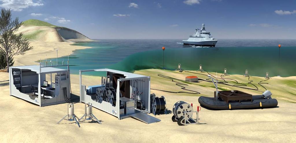
2 General Introduction For many years SAM Electronics has made substantial contributions to Naval Magnetic Ranging and Treatment Technologies and has proven its experience and know-how in the implementation of large-scale national and international range projects. Until recently, Multi Purpose Ranges at fixed locations for ranging of various classes of naval vessels were state-of-the-art. The implementation of these ranges required considerable investments, especially in infrastructure measures and installation. Current trends in magnetic ranging, however, are aimed at setting up cost - efficient mobile range facilities. For many navies, changes in naval policy necessitate out of area deployment of naval forces and their support by magnetic ranging prior to missions, even inremote places. In addition, on account of shrinking budgets, navies require the possibility to use range equipment at various locations at home. Thanks to advanced sensors and versatile application software for data evaluation and analysis, mobile ranges combining high performance with reduced expenditure for equipment and infrastructure are now feasable. SAM Electronics has responded to these trends by introducing its mobile magnetic range system Mora Sym and mobile multi influence range system Mira Sym. Mora sym allows the acquisitation of magnetic field data from all types of naval vessels. Mira Sym extents the measuring potential by using multiinfluence probes for obtaining acoustic, electric pressure and environmential data. System Features The ranging systems Mora Sym and Mira Sym are characterized by the following features: n Containerization of the entire range equipment in two 20 ft standard containers capable of sea, air and land transport n Full independence of the system from shore support n Quick mobilization and demobilisation of the range without the assistance of divers n Active triple probes with front end electronic for magnetic measurements and sensors for electric field, acoustic, pressure as well as seismic measurements. Data transmission by an optical fiber glass transmission path via active underwater interface unit n Probe array suitable for ranging of all classes of naval vessels requiring a minimum of manoeuvering space n Tracking of the vessel, undergoing ranging by Differential Global Positioning System (DGPS) n Extensive system software for data processing and analysis of ranging data 2
3 Equipment Diagram Containers - Power & Storage container - Measuring container Onshore Equipment Evaluation Equipment - Computer systems - Software - DGPS Tracking systems Underwater Facilities - Underwater electronic (UWE) - Underwater cables - Bouys and ropes MORA SYM <- OR-> MIRA SYM Offhore Equipment Probe Array - Magnetic sensor - Pressure sensor Probe Array - Magnetic sensor - Acoustic sensors (high/low) - Electronic sensor - Pressure sensor Additional Probe - Seismic sensor - Water temperature sensor - Waterflow sensor - Water conductivity sensor - Salininty sensor ILS - Documentation - Training 3

4 Container All facilities needed for carrying out ranging operations are contained in a 20 ft measuring container, equipped with two PC-workstations, which serves the dual purpose of providing working space during operation of the range and of storage space when not in use or during transports. View into the storage compartement A second 20 ft. container accommodates the diesel generating set and associated equipment and provides storage space for the offshore equipment and auxiliary facilities required for installation of the wet end components. Due to it s modular design and full containerisation both systems can be easily transported by all conventional means of transportation. In addition to an installation onshore the construction of the container has been ruggedised to suit their deployment on board of naval vessels, giving both systems also a fully seaborne option. The set up of the range facilities is feasible at virtually any coastal place where accessibility, water depth, manoeuvring space and prevailing environmental conditions allow its deployment. Depending on the working conditions the mobilisation for both systems takes a trained skilled crew within 2 working days, while demobilisation can be accomplished in 1 working day. Measuring Container The measuring container is equipped with two workstations for processing, evaluation and presentation of data obtained from the offshore probe system and from tracking of the vessel undergoing ranging. During ranging operations, the measuring container is intended for manned deployment with the workstations serving as redundant Man-Machine-Interface for control of the entire ranging procedure. Fixed windows are provided for the measuring container to allow the visual observation of the ranging procedure. 4

5 Power and Storage Container The power and storage container supports the autonomous operation of the mobile range during its deployment, when access to public power supply is not available. View into the DG compartement The power and storage container is divided into two separate compartments: DG-Set Compartment The DG-set compartment is an unmanned operating room. It is soundproof and accommodates all equipment and facilities required for generation and distribution of 25 kva of electrical power needed to operate the range facilities. A connection box is provided for alternative power supply from the public mains or from the ships mains if the system is employed on board of a naval vessel and for power distribution to the measuring container. Storage Compartment For transport and storage periods the following equipment is stowed in the storage compartment. Brackets, clamps, holders etc. are provided for safe stowage during transports.with the exception of the partition wall dividing the power and storage container into two independent compartments, the sound proof enclosure of the DGset compartment and the large watertight access door to the storage compartment, both containers are of identical mechanical design. 5


6 Advanced Degaussing and Ranging System 1. Active Magnetic Triple Probe 2. Offshore Data Acquisition Unit 3. Optical Data Transmission Path 4. Measuring Container 5. Energy / storage Container 6. Differential GPS 7. Data Processing System

7 Data Processing, Tracking and Communication Systems Power Container Diesel Engine GPS Clock G 3~ Monitor PWR PWR The data processing system accepts the output signals from the probes as well as data derived from the global positioning system. Under consideration of the vessel s track during overruns, the raw data supplied by the probes are converted into measuring data referred to the vessel s coordinate system. DGPS Telemetry IEEE 1394 OPTO Telemetry Data Processing Computer Monitor Course Piot Computer Colour Laser Printer Monochrom Laser Printer In addition the system performs control and monitoring functions during the measuring activity. Two workstation terminals serve as the Man Machine Interface of the system. Communication is effected by Menu Techniques. The design of the software allows utmost support to the operator by system intelligence of the data processing system. DGPS Telemetry Notebook Multi Influence Probes 1 to 5 UWE Auxiliary Probes Several task sequences can be selected by the operator to enable the various functions such as data inputs, measurements, data corrections as well as presentation procedures. The particular facilities of data processing are as follows: n Operator inputs for the definition of measuring parameters comprising the data of the individual ranging task such as ship s data, kind of measurement, environmental conditions etc. n Acquisition of measurement data from the probe array via the Underwater Electronic Unit and the fibre optic transmission path n Data from the DGPS-system are acquired for plotting of the actual course track during the overrun 8


8 Based on the aforementioned data processing features a typical ranging procedure of a vessel will be carried out in the following manner: n Start of the ranging operation with the necessary operator inputs for ship s data, kind of measurement, environmental conditions etc. n Overrun of the vessel in the desired directions with following subsequent functions: - Acquisition of measurement data from the multi-influence sensors - Support of the helmsman during the overrun procedure by display of the actual course track obtained from the DGPS-system on the lap top PC on board of the vessel - Transmission of course data from the DGPSsystem to the shore station - Generation of a realtime plot of selected measuring data and course data by data correlation n Data correction processing - Generation of the magnetic model of the ship undergoing ranging by utilizing the acquired ranging data - Data presentation in form of line diagrams, isomagnetic lines, 3-D displays, frequency spectra and waterfall diagrams according to operator selection 3-D magnetic signature plot By combining data from two or more overruns magnetic calibration of the ship is performed, comprising: n Calculation of the induced and permanent (IM/PM) magnetizations of the vessel, if desired by the operator n Calculation of setting proposals for the shipboard degaussing system, if desired by the operator Example of line diagram 9

9 Functional Description of the DGPS-Tracking System The evaluation of the field data obtained from the probes during overruns of the probe array, necessitates a correlation with the vessels geographic position and its heading, which needs to be established with high precision. Track pilot of intercardinal overrun These navigation data of the vessel are established with the aid of two DGPS receivers which are temporarily installed on board during ranging. Both receivers (one each in the forward and aft section of the vessel) are installed at a predetermined distance on the ship s centerline. This allows to determine the geographic position of the vessel and to calculate its heading. The information of the two receivers are interconnected. The complete data set is provided to the track display computer on board (note book), which is assigned as helmsman s support and serves as the ships DGPS data processing system. The course track data is also provided by radio link to the workstation onshore as on line information. Simultaneously a land based DGPS reference receiver provides precise position data which serve as correction data for the ship s receivers. The correction data are transmitted via data link to the ship s receiver modem and further to the DGPS data processing system. Since the land based reference receiver is placed on an exactly determined geographical reference point, the position error of the system (atmospherical conditions, time error etc.) can be exactly calculated for the area of deployment of the facility. The error data are converted into the respective correction data and serve for the error compensation at the ship s DGPS receivers. 10


10 Underwater Electronic (UWE) The Underwater Electronic Unit serves as the link between the individual probes and the shore based data processing facilities (PC). The UWE is connected to the measuring container by 2000 m of hybrid underwater cable which besides copper cores for power transmission and pinger activation also carries two fibreoptic transmission paths. The half-duplex data transmission between the measuring container and the UWE is effected via these two fibre optic links with one link for each direction of the data flow. The individual probe carriers are connected to the UWE by conventional multi-core copper cable and underwater plugs. The UWE transforms the analogue probe signals into digital data and converts it into an optical signal capable of being transmitted via the fibre optic transmission path. The transmission of data from and to the UWE is carried out by respective optical transmitter / receiver-units, which are part of the UWE and the shore based interface unit. The control of the entire data acquisition and data transmission routines is effected from the Data Processing PC which controls the functions of: n Initialization n Calibration n Data acquisition n Data transfer Command signals are generated as a serial data word by the Data Processing PC converted into an optical signal and transmitted to the UWE via one of fibre optic data links where re-conversion into an electrical signal is effected. Upon start at the command data acquisition a sequential measuring routine is initiated. The output of probes are cyclically acquired, stored in the data acquisition module and upon receipt of the command transfer data transmitted to the Data Processing PC. 11


11 Probe Array The probe carriers consist of a sensor platform for the probes, a protection cage and a tripod at the bottom to adapt the probe carrier to uneven or soft ground conditions. The tripod shape of the probe carriers ensures a firm stand on the seabed even under adverse environmental conditions such as strong currents or silting. In order to enhance the installation capability of the probes, the cable connection is from below, while the rope used for lowering / hoisting of the probe during mobilization / demobilization is attached to the head of the probe carrier. The probes and the tripod probe carriers represent a ready to deploy assembly. Probe carrier for system Mora Sym comprises: n One probe for magnetic signals Probe carrier of system Mira Sym for multiinfluence probes comprises: n One probe for magnetic signals n Two probes for acoustic signals n One probe for electric signals n One probe for pressure signals n One pinger transmitter Printed in Germany Technical alterations reserved SAM Electronics GmbH DS /2010 This probe carriers are made of seawater resistant plastic material. Probe carrier for Mira Sym Each probe carrier comprises a watertight interface box for the connection of the internal probes cabling. The interface box of each carrier is connected to the Underwater Electronics Unit (UWE) by seawater resistant probe cable. Each cable is fitted with special underwater plugs. Additional probe carrier with auxilary sensors for Mira Sym. SAM Electronics GmbH Drives and Special Systems Behringstrasse Hamburg. Germany Phone: +49 (0) Fax +49 (0) DSS@sam-electronics.de
Your Reliable and Competent Partner for Complex Sensor Systems
 Your Reliable and Competent Partner for Complex Sensor Systems Digital Magnetometer DM-Series Ultra High Resolution Digital Data Acquisition DX-Series Mobile and Stationary Electric and Magnetic Multi
SAMCon High Voltage Shore Connection System On-shore and Onboard
 High Voltage Shore Connection System On-shore and Onboard Emission-free Power Supply High Voltage On-shore Power Supply System (OPS) There is increasing pressure on shipping operators and port authorities
AIS 3410 Automatic Identification System
 Automatic Identification System General Unknown vessel on my starboard bow... radio communications like this are a commonplace occurrence for the officer on watch during night time, especially in coastal
Guide to Inductive Moorings
 Guide to Inductive Moorings Real-Time Ocean Observing Systems with Inductive Modem Telemetry Technology Visit Us at sea-birdscientific.com Reach us at info@seabird.com Copyright 2016 Sea-Bird Scientific
LBL POSITIONING AND COMMUNICATION SYSTEMS PRODUCT INFORMATION GUIDE
 LBL POSITIONING AND COMMUNICATION SYSTEMS PRODUCT INFORMATION GUIDE EvoLogics S2C LBL Underwater Positioning and Communication Systems EvoLogics LBL systems bring the benefi ts of long baseline (LBL) acoustic
Acoustic ranging. Greg Hassell. Technical Manager, Acoustics TECS. A presentation to the NPL Conference. 23 May
 Acoustic ranging Greg Hassell Technical Manager, Acoustics TECS A presentation to the NPL Conference 23 May 2007 Acoustic ranging 01 The reasons / requirements for ranging 02 The UK acoustic ranging capability
USBL positioning and communication SyStEmS. product information GUidE
 USBL positioning and communication SyStEmS product information GUidE evologics s2c R usbl - series underwater positioning and communication systems EvoLogics S2CR USBL is a series of combined positioning
DATAMAR 2000 MICROWAVE (26 GHz) RADAR TIDE GAUGE
 RADAR TIDE GAUGE") DATAMAR 2000 MICROWAVE (26 GHz) RADAR TIDE GAUGE BATTERY POWERED COMPACT AND STAND ALONE TIDE GAUGE WITH MICROWAVE RADAR SENSOR (26 GHz) PROVIDING EXTREMELY HIGH PRECISION AND STABILITY Level measurements
DATAMAR 2000 MICROWAVE (26 GHz) RADAR TIDE GAUGE BATTERY POWERED COMPACT AND STAND ALONE TIDE GAUGE WITH MICROWAVE RADAR SENSOR (26 GHz) PROVIDING EXTREMELY HIGH PRECISION AND STABILITY Level measurements
Detecting acoustic emissions of ships & submarines Italian Navy conducts tests with the Autonomous Acoustic Measurement System (SARA)
") Detecting acoustic emissions of ships & submarines Italian Navy conducts tests with the Autonomous Acoustic Measurement System (SARA) This application note discusses the solution used for the detection
Detecting acoustic emissions of ships & submarines Italian Navy conducts tests with the Autonomous Acoustic Measurement System (SARA) This application note discusses the solution used for the detection
Abstract. 1. Introduction
 IBP1572_09 REMOTE EROSION AND CORROSION MONITORING OF SUBSEA PIPELINES USING ACOUSTIC TELEMETRY AND WET-MATE CONNECTOR TECHNOLOGY Howard Painter 1, Stewart Barlow 2, Daniel Clarke 3, Dale Green 4 Copyright
Underwater Signature Management Solutions
 Underwater Signature Management Solutions Samantha Davidson Ultra Electronics PMES, United Kingdom Email:Samantha.Davidson@ultra-pmes.com INTRODUCTION The electromagnetic signature management process for
Attorney Docket No Date: 9 July 2007
 DEPARTMENT OF THE NAVY NAVAL UNDERSEA WARFARE CENTER DIDMSION NEWPORT OFFICE OF COUNSEL PHONE: (401) 832-3653 FAX: (401) 832-4432 NEWPORT DSN: 432-3653 Date: 9 July 2007 The below identified patent application
From Torpedo Fire Control to Sonar at Librascope by Dave Ghen
 From Torpedo Fire Control to Sonar at Librascope by Dave Ghen Librascope made a business decision in the late 1960 s or early 1970 s to try to expand its very successful surface ship and submarine torpedo
PHINS, An All-In-One Sensor for DP Applications
 DYNAMIC POSITIONING CONFERENCE September 28-30, 2004 Sensors PHINS, An All-In-One Sensor for DP Applications Yves PATUREL IXSea (Marly le Roi, France) ABSTRACT DP positioning sensors are mainly GPS receivers
Ultra Electronics Integrated Sonar Suite
 Sonar Systems Crown Copyright Ultra Electronics Integrated Sonar Suite COMPREHENSIVE NETWORK CENTRIC WARFARE SYSTEM COMPRISING: HULL-MOUNT SONAR VARIABLE DEPTH SONAR TORPEDO DEFENCE INNOVATION PERFORMANCE
SmartSenseCom Introduces Next Generation Seismic Sensor Systems
 SmartSenseCom Introduces Next Generation Seismic Sensor Systems Summary: SmartSenseCom, Inc. (SSC) has introduced the next generation in seismic sensing technology. SSC s systems use a unique optical sensing
INTEGRATED SERVICES AND PRODUCTS ACROSS THE FIELD LIFE CYCLE
 INTEGRATED SERVICES AND PRODUCTS ACROSS THE FIELD LIFE CYCLE 4 What we do 6 Why choose us? 7 Service and product capabilities For more than 35 years, we have been providing clients with standalone and
USBL positioning and communication systems. Applications
 USBL positioning and communication systems Offering a powerful USBL transceiver functionality with full benefits of an S2C technology communication link Applications Positioning of offshore equipment >
The Oil & Gas Industry Requirements for Marine Robots of the 21st century
 The Oil & Gas Industry Requirements for Marine Robots of the 21st century www.eninorge.no Laura Gallimberti 20.06.2014 1 Outline Introduction: fast technology growth Overview underwater vehicles development
Automation at Depth: Ocean Infinity and seabed mapping using multiple AUVs
 Automation at Depth: Ocean Infinity and seabed mapping using multiple AUVs Ocean Infinity s seabed mapping campaign commenced in the summer of 2017. The Ocean Infinity team is made up of individuals from
Underwater Vehicle Systems at IFREMER. From R&D to operational systems. Jan Opderbecke IFREMER Unit for Underwater Systems
 Underwater Vehicle Systems at IFREMER From R&D to operational systems Jan Opderbecke IFREMER Unit for Underwater Systems Operational Engineering Mechanical and systems engineering Marine robotics, mapping,
Teledyne Marine Oil and Gas.
 Oil and Gas www.teledynemarine.com/energy Applications in Oil and Gas Teledyne Marine encompasses over 20 brands that offer innovative, highly reliable technology spanning the life cycle of an oil field,
ROM/UDF CPU I/O I/O I/O RAM
 DATA BUSSES INTRODUCTION The avionics systems on aircraft frequently contain general purpose computer components which perform certain processing functions, then relay this information to other systems.
Active Towed Array Sonar Outstanding Over-The-Horizon Surveillance
 Active Towed Array Sonar Outstanding Over-The-Horizon Surveillance ACTAS Anti-Submarine Warfare... a sound decision ACTAS Philosophy Background Detect and Attack Effective Sonar Systems for Surface and
Multi-channel telemetry solutions
 Multi-channel telemetry solutions CAEMAX and imc covering the complete scope imc Partner Newsletter / September 2015 Fig. 1: Schematic of a Dx telemetry system with 4 synchronized transmitter modules Introduction
Deepwater Precommissioning Services
 Deepwater Precommissioning Services Featuring Denizen remote subsea technologies Drilling Evaluation Completion Production Intervention Pipeline & specialty services Nitrogen services Pipeline services
A NOVEL APPROACH TO NON-PIGGABLE SUBSEA PIPELINE INSPECTION
 A NOVEL APPROACH TO NON-PIGGABLE SUBSEA PIPELINE INSPECTION S. Hartmann, Innospection Ltd., Aberdeen Dr. K. Reber, Innospection Germany GmbH, Stutensee, Germany A. Boenisch, Innospection Ltd., Aberdeen
PIPELINE THROUGH-WALL COMMUNICATION CAPABILITIES By Gary Anderson, Offshore Market Development Director, T.D. Williamson, Inc.
 PIPELINE THROUGH-WALL COMMUNICATION CAPABILITIES By Gary Anderson, Offshore Market Development Director, T.D. Williamson, Inc. Introduction Pipeline pigging is a standard regular operational activity performed
Real-Time Current Measurements Improve Vessel Safety and Port Efficiency
 REPRINT Real-Time Current Measurements Improve Vessel Safety and Port Efficiency The ATON System Provides Port Decision Makers With a Reliable and Cost-Effective Alternative in Real-Time Current Monitoring
WORLD CLASS through people, technology and dedication WORLD CLASS through people, technology and dedication
 WORLD CLASS through people, technology and dedication WORLD CLASS through people, technology and dedication 1 2 Acoustic Positioning Systems Hydrofest Aberdeen University Wednesday 31 st March Ian Florence
1 Introduction integrated 3D sonar system for underwater inspection applications
 1 Introduction The Underwater Inspection System (UIS TM ) is an integrated 3D sonar system for underwater inspection applications, specifically port and harbor construction, maintenance, port expansion,
GCMS-3 GONIOSPECTROPHOTOMETER SYSTEM
 MURAKAMI Color Research Laboratory 11-3 Kachidoki 3-Chome Chuo-Ku Tokyo 104 Japan Tel: +81 3 3532 3011 Fax: +81 3 3532 2056 GCMS-3 GONIOSPECTROPHOTOMETER SYSTEM GSP-1 Main System Overview The colour and
- GOMS II. -GOMS II Gearbox Online Monitoring System. P o w e r T r a n s m i s s i o n. Application Note Wind Energy
 -GOMS II Gearbox Online Monitoring System Application Note Wind Energy Content: 1 SYSTEM DESCRIPTION EGOMS II WIND... 3 1.1 System for Online Vibration Measurement...4 1.2 Technical Details of the EGOMS
Introducing The World s First DGPS/AIS Navigation System!
 Introducing The World s First DGPS/AIS Navigation System! MX420 Navigation System: The Most Advanced DGPS/AIS Navigation Solution. MX420AIS Pioneering The Future Standards Of Navigation All navigation
i-tech SERVICES DELIVERING INTEGRATED SERVICES AND PRODUCTS ACROSS THE FIELD LIFE CYCLE
 i-tech SERVICES DELIVERING INTEGRATED SERVICES AND PRODUCTS ACROSS THE FIELD LIFE CYCLE 3 About us 4 What we do 6 Why choose us? 7 Service and product capabilities OUR VALUES Safety Integrity Innovation
Real-Time Oceanography with Inductive Moorings
 Real-Time Oceanography with Inductive Moorings Sea-Bird Electronics, Inc. October 1999 I. Introduction Rapid progress in the development of satellite, RF, and cell-phone telemetry has made real-time, unattended,
Flexible and Modular Approaches to Multi-Device Testing
 Flexible and Modular Approaches to Multi-Device Testing by Robin Irwin Aeroflex Test Solutions Introduction Testing time is a significant factor in the overall production time for mobile terminal devices,
A Hybrid Immersive / Non-Immersive
 A Hybrid Immersive / Non-Immersive Virtual Environment Workstation N96-057 Department of the Navy Report Number 97268 Awz~POved *om prwihc?e1oaa Submitted by: Fakespace, Inc. 241 Polaris Ave. Mountain
RDT&E BUDGET ITEM JUSTIFICATION SHEET (R-2 Exhibit)
") , R-1 #49 COST (In Millions) FY 2000 FY2001 FY2002 FY2003 FY2004 FY2005 FY2006 FY2007 Cost To Complete Total Cost Total Program Element (PE) Cost 21.845 27.937 41.497 31.896 45.700 57.500 60.200 72.600
, R-1 #49 COST (In Millions) FY 2000 FY2001 FY2002 FY2003 FY2004 FY2005 FY2006 FY2007 Cost To Complete Total Cost Total Program Element (PE) Cost 21.845 27.937 41.497 31.896 45.700 57.500 60.200 72.600
Aquatec Solutions CUSTOM SUBSEA MEASUREMENT & COMMUNICATION SOLUTIONS
 Aquatec Solutions CUSTOM SUBSEA MEASUREMENT & COMMUNICATION SOLUTIONS Solutions Aquatec has a long history of innovation and was founded in 1990 by the current managing director as a specialist consultancy
RFeye Arrays. Direction finding and geolocation systems
 RFeye Arrays Direction finding and geolocation systems Key features AOA, augmented TDOA and POA Fast, sensitive, very high POI of all signal types Capture independent of signal polarization Antenna modules
Non-Data Aided Doppler Shift Estimation for Underwater Acoustic Communication
 Non-Data Aided Doppler Shift Estimation for Underwater Acoustic Communication (Invited paper) Paul Cotae (Corresponding author) 1,*, Suresh Regmi 1, Ira S. Moskowitz 2 1 University of the District of Columbia,
SAAB SEA POWER CAPABILITIES FOR MALAYSIA AND APAC LIMA Robert Hewson Vice President Head of Communications, Saab Asia Pacific
 1 SAAB SEA POWER CAPABILITIES FOR MALAYSIA AND APAC LIMA 2017 Robert Hewson Vice President Head of Communications, Saab Asia Pacific This document and the information contained herein is the property of
Author s Name Name of the Paper Session. DYNAMIC POSITIONING CONFERENCE October 10-11, 2017 SENSORS SESSION. Sensing Autonomy.
 Author s Name Name of the Paper Session DYNAMIC POSITIONING CONFERENCE October 10-11, 2017 SENSORS SESSION Sensing Autonomy By Arne Rinnan Kongsberg Seatex AS Abstract A certain level of autonomy is already
LEADING THE WAY FROM SEA TO LAND SURVEILLANCE RADAR SOLUTIONS
 LEADING THE WAY FROM SEA TO LAND SURVEILLANCE RADAR SOLUTIONS SITUATIONAL INTELLIGENCE, THE WORLD OVER A Kelvin Hughes radar is the primary tool for long range threat detection. On land and at sea we provide
RHE12. Hazardous Area Coriolis Mass Flow Transmitter. Features. Applications. Benefits
 RHE12 Hazardous Area Coriolis Mass Flow Transmitter Features Field mounting Compact, pressure safe housing ATEX and CSA approvals for installation in hazardous areas 24 VDC power supply Configurable analog
ADVANCED DISTRIBUTED WIDEBAND DATA ACQUISITION SYSTEM
 ADVANCED DISTRIBUTED WIDEBAND DATA ACQUISITION SYSTEM Albert Berdugo Vice President of Advanced Product Development Teletronics Technology Corporation Newtown, PA USA ABSTRACT Wideband data acquisition
DP Operator Course Training Manual HPR
 - Hydroacoustic Position Reference System consists of transducer(s) onboard a vessel communicating with transponder(s) placed on the seabed. The transducers are lowered beneath the hull, and when a transponder
from ocean to cloud DUAL-CONDUCTOR CAPABILITIES IN WET PLANT DESIGN QUALIFICATION SEATRIALS
 DUAL-CONDUCTOR CAPABILITIES IN WET PLANT DESIGN QUALIFICATION SEATRIALS Maurice E. Kordahi, Jeremiah Mendez, Ralph J. Rue, Michael M. Sanders, Robert K. Stix, Ryan Wilkison (TE SubCom) Email: mkordahi@subcom.com
Ship Signatures Department (Code 70) Paul Luehr, Acting Department Head
 Paul Luehr, Acting Department Head") Paul Luehr, Acting Department Head CAPT Mark Vandroff Commanding Officer, NSWCCD June 12, 2018 Dr. Paul Shang Technical Director (Acting), NSWCCD Briefing Agenda Overview Our Mission and Vision Acquisition
Paul Luehr, Acting Department Head CAPT Mark Vandroff Commanding Officer, NSWCCD June 12, 2018 Dr. Paul Shang Technical Director (Acting), NSWCCD Briefing Agenda Overview Our Mission and Vision Acquisition
HMS-12M. HMS-12M Broadband Hull-Mounted Minehunting Sonar ATLAS ELEKTRONIK. ... a sound decision. Mine Warfare System
 HMS-12M Broadband Hull-Mounted Minehunting Sonar HMS-12M Mine Warfare System... a sound decision ATLAS ELEKTRONIK Force Multiplier The broadband Hull-Mounted Minehunting Sonar ATLAS HMS-12M has been designed
Underwater Acoustic Communication and Modem-Based Navigation Aids
 Underwater Acoustic Communication and Modem-Based Navigation Aids Dale Green Teledyne Benthos 49 Edgerton Drive North Falmouth, MA 02556 USA Abstract. New forms of navigation aids for underwater vehicles
ASO 713/723 Hull-Mounted Active Sonar
 ASO 713/723 Hull-Mounted Active Sonar ASO Anti-Submarine Warfare... a sound decision ATLAS ELEKTRONIK Naval Underwater Theatre ASO The ATLAS ELEKTRONIK Hull-Mounted Sonar (HMS) systems ASO 713/723 belong
OPTICAL FIBER AND CONNECTORS: CRITICAL COMPONENTS OF MANY ADVANCED SUBSEA SYSTEMS. Perry Wright: Fiber-optics Technology Manager, Ocean Design Inc,
 OPTICAL FIBER AND CONNECTORS: CRITICAL COMPONENTS OF MANY ADVANCED SUBSEA SYSTEMS Abstract Perry Wright: Fiber-optics Technology Manager, Ocean Design Inc, Since the first connectorized, subsea fiber-optic
Engtek SubSea Systems
 Engtek SubSea Systems A Division of Engtek Manoeuvra Systems Pte Ltd SubSea Propulsion Technology AUV Propulsion and Maneuvering Modules Engtek SubSea Systems A Division of Engtek Manoeuvra Systems Pte
New GENERATION ACOUSTIC. single solution for all underwater communication needs.
 MATS 3G // New GENERATION ACOUSTIC TELEMETRY SYSTEM MATS 3G is an underwater acoustic modem that offers a single solution for all underwater communication needs. Its state-of-the-art DSP (Digital Signal
08/10/2013. Marine Positioning Systems Surface and Underwater Positioning. egm502 seafloor mapping
 egm502 seafloor mapping lecture 8 navigation and positioning Marine Positioning Systems Surface and Underwater Positioning All observations at sea need to be related to a geographical position. To precisely
w w w. s e i s m i c i n s t r u m e n t s. c o m Page 1
 w w w. s e i s m i c i n s t r u m e n t s. c o m Page 1 Seismic Instruments offers three different configurations of data acquisition system (Cabled, Cable-Free and Mixed) in a wide range of options,
MINIMUS MINIMUS+ SMART SEISMIC DIGITISER WITH ADVANCED DATA-PROCESSING CAPABILITY AND SOFTWARE COMMUNICATIONS
 MINIMUS MINIMUS+ SMART SEISMIC DIGITISER WITH ADVANCED DATA-PROCESSING CAPABILITY AND SOFTWARE COMMUNICATIONS KEY FEATURES > > Advanced software communications for quick and easy instrument and data management
Subsea Control Systems
 Subsea Control Systems Simplifying Subsea Production INGENIOUS SIMPLICITY Proserv s direct hydraulic and multiplexed production subsea control systems provide control and shutdown of subsea wells together
MTS. Stationary Meter Test Systems. - Source Systems - Amplifiers - Reference Meters - Error Calculators - Scanning Heads - Transformers
 MTS Stationary Meter Test Systems - Source Systems - Amplifiers - Reference Meters - Error Calculators - Scanning Heads - Transformers Design of a Standard System Design of an Advanced System Our Competence
MARKSMAN DP-INS DYNAMIC POSITIONING INERTIAL REFERENCE SYSTEM
 cc MARKSMAN DP-INS DYNAMIC POSITIONING INERTIAL REFERENCE SYSTEM Sonardyne s Marksman DP-INS is an advanced navigation-based Position Measuring Equipment (PME) source for dynamically positioned (DP) rigs.
Acoustic Communications and Navigation for Mobile Under-Ice Sensors
 DISTRIBUTION STATEMENT A. Approved for public release; distribution is unlimited. Acoustic Communications and Navigation for Mobile Under-Ice Sensors Lee Freitag Applied Ocean Physics and Engineering 266
AVL X-ion. Adapts. Acquires. Inspires.
 AVL X-ion Adapts. Acquires. Inspires. THE CHALLENGE Facing ever more stringent emissions targets, the quest for an efficient and affordable powertrain leads invariably through complexity. On the one hand,
DROP SHAPE ANALYZER DSA100 THE VERSATILE HIGH-END INSTRUMENT FOR ANALYZING COATING AND WETTING PROCESSES
 DROP SHAPE ANALYZER DSA100 THE VERSATILE HIGH-END INSTRUMENT FOR ANALYZING COATING AND WETTING PROCESSES PRECISION AND PERFECTION QUITE AUTOMATICALLY Options for complete software-controlled surface analysis
Summary. Methodology. Selected field examples of the system included. A description of the system processing flow is outlined in Figure 2.
 Halvor Groenaas*, Svein Arne Frivik, Aslaug Melbø, Morten Svendsen, WesternGeco Summary In this paper, we describe a novel method for passive acoustic monitoring of marine mammals using an existing streamer
Intelligent Dual Channel NAVTEX Receiver System with Optional Instrument Data display
 NAV6 Intelligent Dual Channel NAVTEX Receiver System with Optional Instrument Data display High quality and reliable instrumentation with a single clear back-lit display for information, safety and security
Advanced Test Equipment Rentals ATEC (2832)
") Established 1981 Advanced Test Equipment Rentals www.atecorp.com 800-404-ATEC (2832) Electric and Magnetic Field Measurement For Isotropic Measurement of Magnetic and Electric Fields Evaluation of Field
Established 1981 Advanced Test Equipment Rentals www.atecorp.com 800-404-ATEC (2832) Electric and Magnetic Field Measurement For Isotropic Measurement of Magnetic and Electric Fields Evaluation of Field
SYSTEM 5900 SIDE SCAN SONAR
 SYSTEM 5900 SIDE SCAN SONAR HIGH-RESOLUTION, DYNAMICALLY FOCUSED, MULTI-BEAM SIDE SCAN SONAR Klein Marine System s 5900 sonar is the flagship in our exclusive family of multi-beam technology-based side
ACOUSTIC RESEARCH FOR PORT PROTECTION AT THE STEVENS MARITIME SECURITY LABORATORY
 ACOUSTIC RESEARCH FOR PORT PROTECTION AT THE STEVENS MARITIME SECURITY LABORATORY Alexander Sutin, Barry Bunin Stevens Institute of Technology, Castle Point on Hudson, Hoboken, NJ 07030, United States
GNSS applications in Flight Test Instrumentation Systems. R. Urli
 GNSS applications in Flight Test Instrumentation Systems R. Urli 19.06.2008 Wi\EC-STD-d\24.03.2004 Contents Flight Test and FT Instrumentation Time Need for time IRIG-B Time distribution Time synchronisation
spy pig Tracking systems
 spy pig Tracking systems Spy pig Transmitters For the most reliable signal available, the SPY Pig Transmitter uses low frequency signals to effectively and consistently penetrate a steel pipe wall. We
NEMO - NIXIE Enhanced Modular Option Surface Ship Torpedo Defense (SSTD) Program Update Test Results
 Program Update Test Results") NEMO - NIXIE Enhanced Modular Option Surface Ship Torpedo Defense (SSTD) Program Update Test Results John P. Fumo, CTO ArgonST, Inc 12701 Fair Lakes Circle, Fairfax, VA 22033 Abstract NIXIE Enhanced Modular
NEMO - NIXIE Enhanced Modular Option Surface Ship Torpedo Defense (SSTD) Program Update Test Results John P. Fumo, CTO ArgonST, Inc 12701 Fair Lakes Circle, Fairfax, VA 22033 Abstract NIXIE Enhanced Modular
The below identified patent application is available for licensing. Requests for information should be addressed to:
 DEPARTMENT OF THE NAVY OFFICE OF COUNSEL NAVAL UNDERSEA WARFARE CENTER DIVISION 1176 HOWELL STREET NEWPORT Rl 02841-1708 IN REPLY REFER TO Attorney Docket No. 300001 25 February 2016 The below identified
Teledyne Oil & Gas Innovation and Subsea Reliability
 A Member of Innovation and Subsea Reliability www.teledyneoilandgas.com Technologies A Member of Seismic Instruments Imaging Vehicles Photo Courtesy BMT has been proudly serving the oil and gas industry
Precise, simultaneous data acquisition on rotating components Dx telemetry: from single channels to complex multi-component systems
 Precise, simultaneous data acquisition on rotating components Dx telemetry: from single channels to complex multi-component systems Application: Dx telemetry used to test the complex drive train in this
OFFSHORE ENERGY. BUYER S GUIDE HYDROlog Hydrotest Logger Range. Simply advanced
 OFFSHORE ENERGY BUYER S GUIDE HYDROlog 3000 Hydrotest Logger Range Simply advanced HYDROlog 3000 - simply advanced The HYDROlog 3000 instruments form the core of the new HYDRO 3000 range of hydrotest monitoring
Survey of a World War II Derelict Minefield with the Fluorescence Imaging Laser Line Scan Sensor
 Survey of a World War II Derelict Minefield with the Fluorescence Imaging Laser Line Scan Sensor Dr. Michael P. Strand Naval Surface Warfare Center Coastal Systems Station, Code R22 6703 West Highway 98
IMPLEMENTATION OF CABLE HEAD REMOTE SWITCH UNIT TO INCREASE EFFICIENCY AND PRODUCTIVITY OF ONBOARD TESTING IN THE ABSENCE OF LAND INSTALLATIONS
 IMPLEMENTATION OF CABLE HEAD REMOTE SWITCH UNIT TO INCREASE EFFICIENCY AND PRODUCTIVITY OF ONBOARD TESTING IN THE ABSENCE OF LAND INSTALLATIONS Stephen Coy, Jon Elliott (Alcatel-Lucent Submarine Networks)
Moving Test - MT3000
 Moving Test - MT3000 Three-Phase Portable Test System Keep ahead with Modular Design The Modular Concept The MT3000 is based on a real modular design concept to provide the greatest possible flexibility
GLOBAL POSITIONING SYSTEM SHIPBORNE REFERENCE SYSTEM
 GLOBAL POSITIONING SYSTEM SHIPBORNE REFERENCE SYSTEM James R. Clynch Department of Oceanography Naval Postgraduate School Monterey, CA 93943 phone: (408) 656-3268, voice-mail: (408) 656-2712, e-mail: clynch@nps.navy.mil
Subsea infrastructure in MRE ICOE November 6, By Don Bryan, BSc, MBA General Manager Pacific Northwest Operations
 Subsea infrastructure in MRE ICOE November 6, 2014 By Don Bryan, BSc, MBA General Manager Pacific Northwest Operations Agenda MacArtney overview Sample subsea infrastructure and components Case study Subsea
WORLD CLASS through people, technology and dedication
 WORLD CLASS through people, technology and dedication WORLD CLASS through people, technology and dedication 1 2 Acoustic Positioning Systems Hydrofest Robert Gordon University Scott Sutherland Building
Applications. > > Oil & Gas. > > RoVs and auvs. > > Oceanography. > > Monitoring stations. > > Seismic. > > Networks and relay chains
 Underwater acoustic Modems EvoLogics S2CR - series underwater acoustic modems provide full-duplex digital communication delivering an excellent performance, resistant to the challenges of the dynamic subsea
Experiences with Fugro's Real Time GPS/GLONASS Orbit/Clock Decimeter Level Precise Positioning System
 Return to Session Directory DYNAMIC POSITIONING CONFERENCE October 13-14, 2009 Sensors Experiences with Fugro's Real Time GPS/GLONASS Orbit/Clock Decimeter Level Precise Positioning System Ole Ørpen and
Dynatel. 2273M Cable/Pipe and Fault Locators 2273M-iD Cable/Pipe/Fault and Marker Locators with id Read/Write
 3 Dynatel 2273M Cable/Pipe and Fault Locators 2273M-iD Cable/Pipe/Fault and Marker Locators with id Read/Write Designed to be more accurate, faster and more integrated than any other locator on the market,
Model 4xx. Plug-in Series Of FSK Modems USER GUIDE. (TI) 20 Jan 06 DWG: A GDI COMMUNICATIONS LLC PO Box I-80 Exit 1 Verdi, NV 89439
 20 Jan 06 DWG: A GDI COMMUNICATIONS LLC PO Box I-80 Exit 1 Verdi, NV 89439") Model 4xx Plug-in Series Of FSK s USER GUIDE (TI) 20 Jan 06 DWG: A01164 GDI COMMUNICATIONS LLC PO Box 1330 280 I-80 Exit 1 Verdi, NV 89439 Phone: (775) 345-8000 Fax: (775) 345-8010 Web: www.sgdi.com Email:
Model 4xx Plug-in Series Of FSK s USER GUIDE (TI) 20 Jan 06 DWG: A01164 GDI COMMUNICATIONS LLC PO Box 1330 280 I-80 Exit 1 Verdi, NV 89439 Phone: (775) 345-8000 Fax: (775) 345-8010 Web: www.sgdi.com Email:
Marine Construction Support & Dimensional Control
 Page 1 of 5 Marine Construction Support & Dimensional Control Key Specifications Surface and Subsurface Positioning IRM Support Lay Support Trench Suport Installation Support Metrology As-Built Heavy Lift
Development of Microsatellite to Detect Illegal Fishing MS-SAT
 Development of Microsatellite to Detect Illegal Fishing MS-SAT Ernest S. C. P. Bintang A.S.W.A.M. Department of Aerospace Engineering Faculty of Mechanical and Aerospace Engineering Institut Teknologi
The Use of Optical Fiber Rotary Joints in Towed Sonar Array and Seismic Streamer Systems
 The Use of Optical Fiber Rotary Joints in Towed Sonar Array and Seismic Streamer Systems Jesse Diggs and Barry Zhang 1 An Introduction to Military and Commercial Towed Sonar Technology The ocean is alive
Underwater Acoustic Communication and Positioning State of the Art and New Uses
 Underwater Acoustic Communication and Positioning State of the Art and New Uses Radio signals Work only on very short distances Salty water particularly problematic No underwater GPS Cables Too heavy,
A Report On Tide Gauges In Singapore. 1 The Republic of Singapore is an island city-state situated at the southern tip of
 A Report On Tide Gauges In Singapore Introduction 1 The Republic of Singapore is an island city-state situated at the southern tip of Peninsula Malaysia, approximately 1 north of the equator. It consists
Navigation Sensor Technology Aids Marine Seismic Survey
 Page 1 of 5 Navigation Sensor Technology Aids Marine Seismic Survey Al Hise, NCS SubSea; John Thorson, Sparton Navigation and Exploration; Craig Lippus, Geometrics April 1, 2012 A new digital compass provides
Seafloor Networks. OceanWorks Solutions. Engineering Your Subsea Solutions
 OceanWorks Solutions Seafloor Networks atmospheric diving submarine rescue subsea tooling subsea systems engineering seafloor networks Engineering Your Subsea Solutions OceanWorks OceanWorks Experience
spy pig Tracking systems
 spy pig Tracking systems PIPELINE INSPECTION COMPANY Spy pig Transmitters For the most reliable signal available, the SPY Pig Transmitter uses low frequency signals to effectively and consistently penetrate
 Application Note 92 www.seabird.com +1 425-643-9866 seabird@seabird.com Real-Time Oceanography with Inductive Moorings and Inductive Modem Module (Revised October 2016) I. Introduction Rapid progress in
COASTAL MONITORING BUOY CMB 3280
 AANDERAA INSTRUMENTS DATA COLLECTING INSTRUMENTS FOR LAND SEA AND AIR COASTAL MONITORING BUOY CMB 3280 A moored data buoy for measuring - meteorological conditions - wave height and wave period - current
Problem Areas of DGPS
 DYNAMIC POSITIONING CONFERENCE October 13 14, 1998 SENSORS Problem Areas of DGPS R. H. Prothero & G. McKenzie Racal NCS Inc. (Houston) Table of Contents 1.0 ABSTRACT... 2 2.0 A TYPICAL DGPS CONFIGURATION...
UNDERWATER ACFM CRACK MICROGAUGE MODEL U31D PRODUCT INFORMATION
 TSC INSPECTION SYSTEMS UNDERWATER ACFM CRACK MICROGAUGE MODEL U31D PRODUCT INFORMATION The Model U31 Underwater ACFM Crack Microgauge represents the latest in ACFM subsea inspection technology. The new
SYSTEMS AND COMPONENTS FOR TRANSFORMER TESTING
 SYSTEMS AND COMPONENTS FOR TRANSFORMER TESTING 9.11/2 Transformer Testing n Type tests n Routine tests n Special tests n Applicable for tests on power and distribution transformers in factory and on-site