Performance Audit for the Public Safety Radio/Paging/Mobile Data Communications Systems of the Columbia 911 Communications District
|
|
|
- Rudolph Perkins
- 5 years ago
- Views:
Transcription


1 PALLANS ASSOCIATES COMMUNICATION CONSULTANTS for the Public Safety Radio/Paging/Mobile Data Communications Systems of the Columbia 911 Communications District PALLANS ASSOCIATES Communications Consultants 7753 Lily Trotter Street North Las Vegas, NV 89084
2 TABLE OF CONTENTS Executive Summary 1 Available Technologies Introduction 4 Conventional Radio Systems 45 Methodology Simulcast 46 Analysis of Documentation 4 Satellite Receivers/ Voters 46 Initial Propagation Study 4 Trunking 47 Kickoff Meeting 4 Bi-Directional Amplifiers 47 User discussions 5 Vehicular Repeaters 48 Site Visits 5 P25 48 FCC License Review 6 Digital Mobile Radio 50 Analysis of user Surveys 7 Broadband LTE 51 Assessment Observations Findings System Design for The District 53 General 8 System Management 53 Existing Radio System 10 System Performance 53 Radio Sites 11 Microwave System Performance 54 Dispatch Centers 12 Alternate Site Analysis 55 Microwave System 22 Recommendations Existing System Coverage 24 Technology 57 FCC Licenses 27 Dispatch Systems 57 Licensing Discrepancies 28 Coverage 58 Site Equipment 29 Interference 59 Radio Inventories 29 System Maintenance 59 Analysis Microwave 59 Radio System Coverage 31 Interoperability 60 Coverage in the District 32 Site Improvements 60 Terrain Issues 33 System Recommendations 60 Propagation Mapping 36 System Oversight 61 Propagation Map Analysis 38 Vehicular Repeaters 62 Capacity 39 Vehicle Location 62 Interoperability 40 Mobile Data 63 System Life Cycle 43 Fire Department Paging 63 Radio Specifications 44 Equipment Replacement 63 A B C D ATTACHMENTS Radio Licenses Terrain Studies System Coverage Maps User Survey Summary
3 Communicaion Consultants EXECUTIVE SUMMARY Pallans Associates is pleased to present this Radio Systems Assessment and Recommendations to the. The purpose of this assessment is to provide an analysis of the current communication systems utilized by the and to provide recommendations for any future growth or improvement of the District s primary VHF radio communication system. The recommendations presented are based upon current advances in technology for radio communication and the best practices of local government public safety entities nationwide. The intent of this report is not to provide the technical solutions but rather to identify any issues and to provide logical steps to take to resolve them. Pallans Associates, through site inspections, user interviews and surveys, radio propagation mapping programs and FCC data research has evaluated the radio systems of the. The challenges associated with radio communications in the future are quite different from what they were in the past. The need to communicate effectively is an important part of the s agencies abilities to provide services to the citizens of Columbia County. The participating agencies recognize the importance of having properly functioning communications networks that enable the appropriate first responder disciplines to respond to any threat or challenge that may present itself, be it cross agency, cross discipline or cross jurisdiction. Radio systems provide the critical wireless communication link between 911 dispatchers, fire/rescue, law enforcement, emergency medical responders, public works and general government personnel. Radio systems typically manage traffic for a particular agency or jurisdiction. However, larger incidents often require interagency communications, referred to as interoperability. Interoperability is essential to assure first responders can communicate effectively in the event of a large scale emergency or disaster. The Columbia 911 District operates a VHF radio system for all of its participating municipal and County agencies. Dispatch functions for public safety entities, police, fire and medical services, are provided by the District as are 911 services. Radio coverage of the County is a challenge that is addressed in this report. Interoperability between District agencies and the County are maintained on the County operated radio system since it is shared by all County public safety agencies. Primary concerns of the District are radio coverage, current levels of performance, costs and the possible migration paths to future technology. This report addresses all of these aspects. Page 1
4 The initial step of this project was familiarization with the county, the Communications District and the radio sites themselves. Meetings with District management and with representatives of the user agencies helped to provide a picture that provided direction for our research. Through analysis of FCC licensing documentation and our own mathematical modeling of the theoretical system performance we were able to develop a course of action to take. This led to determining all of the factors that have impacted the radio system over its years of operation. These initial stages led us to determine that the radio system, its facilities and equipment and its operation is sound. The biggest issue affecting the radio system is the fact that Columbia County is a rural area with a rugged interior. Radio waves do not like foliage, cliffs, valleys and winding roadways. Our models and the user surveys agree that coverage in the populated area is good with a few exceptions. The use of simulcasting from six radio sites actually provides better coverage than having the six sites operating independently. User radio equipment, also known as subscriber units, is performing relatively well considering that the majority of units are as old as the radio system, 12 years or more. Statistically, the life span of a portable radio is 7 years and a mobile is 10 years. Virtually all of the subscriber units have exceeded these ages. During this extended time there has not been any planned maintenance or preventative maintenance program in effect. We therefore believe that some of the reported problems are due to mistuned radios. Replacement with newer technology radios with higher performance specifications will also address the problem. Adding vehicular repeaters to mobile units will significantly improve coverage from handheld radios in rural areas. A significant amount of time for this project was spent analyzing the coverage of the system and several specific impacts that affect performance. The terrain is very difficult to penetrate due to its mountainous characteristics The actual radiation patterns from the infrastructure antennas, in many cases does not penetrate to the target areas but rather flies over them The simulcast design has created areas where signals from multiple sites overlap each other causing interference between them Reorienting antennas or replacing them with antennas that focus the waves downward may improve system performance System operation is very good. All of the agencies commented on how well the dispatch center operates. Some users feel that there should be in house technical staff. Pallans Associates believes that existing contracted technical assistance is more than adequate but there should be more done in house with respect to 2
5 reporting system metrics on performance and technical issues to be able to predict problem areas. While Pallans Associates often recommends that radio systems of this general vintage or older be replaced with more modern high technology systems such as P25 digital technology and trunking, we cannot say the same for the Columbia County 911 Communications District. In the environment of northwestern Oregon the current VHF conventional technology is more than adequate. Replacement of infrastructure and subscriber units will certainly benefit the system operation but there is no need for a technology change here. The federal government will be implementing the FirstNet Broadband Public Safety Network in a few years. FirstNet will provide nationwide broadband digital coverage for public safety. That will be the impetus for local system growth and replacement. Until that time we believe the District should remain where it is technologically but it should consider upgrading to P25 in the future. However, it is important that the current radio system be upgraded to 2015 standards. 3
6 INTRODUCTION The contracted with Pallans Associates,, to perform an audit of all radio systems and communication networks utilized by The District. This audit consists of an analysis of the existing systems from both technical and operational aspects. It also provides an evaluation of the current interoperability between agencies and communities. The goal is to provide recommendations for the future improvements of the District's radio system and a migration strategy to implement the recommended changes. Methodology Analysis of Support Documentation Prior to attending the kickoff meeting Pallans Associates compiled available data regarding the communication systems of the by accessing Federal Communication Commission databases and analyzing the radio licenses of The District. Additionally the local geography was studied by viewing topographic maps of the area and considering the types of terrain, forestation and vegetation that is common to the area. Preliminary contact was made with Day Wireless, the District's maintenance and equipment provider. Initial Propagation Study Utilizing data available from The District s radio licenses mathematical models were developed to depict the probable radio wave propagation that Pallans Associates could expect from the existing radio systems. These models take into consideration the transmitter locations, antenna elevations, power and frequency of the transmitters. Factors are included for the type of terrain, the density of the forestation, as well as estimates of local building densities. Kickoff Meeting On March 24, 2015 a meeting was held with staff and radio system users from several of the agencies in The District and the surrounding area. Introductions were made by District personnel and a representative of Pallans Associates. The purpose of the meeting was to introduce Pallans Associates to the radio system users of the. The topics discussed included how Pallans Associates would approach the goals of The District with respect to assessing all of The District s communications capabilities, assure that FCC requirements are met with respect to equipment and licensing and making recommendations as to what should be done to improve communications to assure that future growth and performance requirements are met. 4
7 Users provided information regarding their opinions as to where the existing radio system was lacking in performance. As part of the meeting site visits were scheduled for March 25th and March 26th. Pallans Associates confirmed that the desired deliverables for this project includes; An analysis of current capabilities A needs assessment for future communications A recommendation for future communications improvements Verification that the existing systems meet all federal, state and local requirements Attendees at the meeting included representatives of; The Operations Manager and Technical Manager The Columbia County Sheriff's Office The Columbia County Roads Department Columbia River Fire Rescue Scappoose Fire Department In order to accomplish this project Pallans Associates has undertaken the following tasks. User Discussions During the kickoff meeting Pallans Associates discussed the current status of the District s communication systems with the participants. This was done in order to get their ideas and to assure that they had completely responded to the user surveys that had been previously distributed. An open discussion between users was encouraged in order to allow the participants to come to consensus regarding any issues that were raised. The questions asked by the Pallans representative were designed to stimulate their involvement with the project and to elicit valid responses to the questions in the survey. The discussion topics were designed to identify key operational and performance needs of the user community and to determine how well the current system meets these needs. The users in attendance provided insightful and valuable feedback for use in developing recommendations for the future. Site Visits Pallans Associates visited all of the radio sites listed in FCC licenses issued to the. This did not include the two receive only sites at the Scappoose Police Department and at Meissner Lookout. These visits 5
8 took place on March 25th and March 26th. These sites are dedicated radio sites that are both District owned sites and sites owned by others. The Sites listed in Table 1 are those sites that house primary communications equipment. TABLE 1 PRIMARY RADIO SITES Site St. Helens Dispatch Clatskanie Mountain Columbia Heights Corey Hill Bald Hill Green Mountain Usage Primary tower site simulcast system and dispatch center location Primary tower site simulcast system Primary tower site simulcast system Primary tower site simulcast system Primary tower site simulcast system Primary tower site simulcast system The Sites listed in Table 2 are those sites that house satellite receiver equipment. TABLE 2 SATELLITE RECEIVER SITES Site Scappoose Police Dept. Meissner Lookout Usage Satellite receivers for simulcast system Satellite receivers for simulcast system Site visits are an integral part of the assessment process. Radio equipment is inspected as are towers, antenna, cabling, grounding and emergency power. These inspections assist in determining which equipment must be upgraded or replaced. If system expansions are recommended the inspections provide data on how much space is available in the facilities and how additional antennas may be installed. FCC License review Pallans Associates has access to all of the Federal Communication Commission license databases. The licenses are reviewed and any discrepancies between the licenses and the actual sites and systems are noted. As part of this process Pallans Associates will provide update information related to The District s licenses when necessary for accuracy and to prevent any possible violations of FCC Rules. 6
9 Analysis of User Surveys. The user survey is the most important tool that Pallans Associates uses. Not only does it provide information describing the actual equipment in use but it also gets the opinions of the users relevant to the existing systems and where they would like to focus future implementations or upgrades. Analysis of the surveys takes an in-depth look at such issues as; System coverage System capacity Interference Interoperability needs and capabilities Existing user hardware Users were asked to describe any specific issues or deficiencies they found with the existing radio system. These included topics relating to; Poor coverage areas Interference Insufficient frequencies Lack of interoperability The analysis provides significant insight when making recommendations for the future especially relating to technology, frequencies and standards. A summary of the key results of the user surveys is included as Attachment D to this report. 7
10 FINDINGS ASSESSMENT General The is located in Columbia County in north western Oregon. The Communications District provides communications for all public safety agencies within the County. It operates the County dispatch 911 center. TABLE 3 - Members of The AGENCY NAME CONTACT ADDRESS PHONE NUMBER Columbia County Sheriff Jeff 901 Port Ave. St. Helens, OR Ofc: Sheriff Dickerson Clatskanie RFPD Chief Steve Sharek P.O. Box 807 Clatskanie, OR Ofc: Clatskanie PD Chief Marvin P.O. Box 9 Clatskanie, OR Ofc: Hoover Columbia City PD Chief Michael P.O. Box 189 Columbia City, OR Ofc: McGlothlin Rainier PD Chief Gregg Griffith 106 West B Street Rainier, OR Ofc: Columbia River Fire & Rescue Chief Jay Tappan 270 Columbia Blvd. St. Helens, OR Ofc: Vernonia RFPD Chief Dean Smith 555 E. Bridge St. Vernonia, OR Ofc: Vernonia PD Chief Mike Conner 1001 Bridge St. Vernonia, OR Ofc: Metro West Ambulance Services Dept. of Emergency Management Mist-Birkenfeld RFPD Jeff Mathia (Vernonia Ambulance Service) Vincent Aarts Acting Supervisor 5475 NE Dawson Creek Drive Hillsboro, OR Ofc: McNulty Way St. Helens, OR Ofc: Chief Joe Hwy. 202 Mist, OR Ofc: Kaczenski Scappoose RFPD Chief Mike Greisen P.O. Box 625 Scappoose, OR Ofc: Scappoose PD Chief Norm Miller E. Columbia Scappoose, OR Ofc: Ave. St. Helens PD Chief Terry Moss 150 S. 13th St. St. Helens, OR Ofc: Oregon State Police Oregon State Forestry Columbia Co. Road & Parks To be Assigned Malcolm Hiatt, Unit Forester David Hill, Public Works Director Industrial St. Helens, OR Ofc: Way, Suite A 405 E. Street Columbia City, OR Ofc: Oregon Street St. St. Helens, OR Ofc: The Columbia Communications District is a special taxing authority for all of Columbia County. The District provides all call taking and dispatching for all 8

11 public safety agencies based in Columbia County. Table 3 lists the members of the Advisory Committee. The County's population is approximately 49,300 and it is primarily a rural county with approximately 50% of its residents commuting to the Portland, Oregon area and the Vancouver and Longview, Washington areas for employment. The major industry in the County is lumber and paper manufacturing. Columbia County encompasses 688 square miles. It's northern and eastern boundaries are made up of more than 53 miles of the shoreline of the Columbia River. The only primary highway is U.S. Hwy 30 which runs north and south on the eastern side of the County and then east-west on the northern side of the County. State Route 47 is a north-south road on the western side of the County. With the exception of Hwy 30 most roads in the County follow natural terrain paths such as canyons and river/creek routes. See FIGURE 1. FIGURE 1 Columbia County Map 9


12 The District provides the public safety voice and data communications for the entire County. Interoperability is provided to adjacent counties in both Oregon and Washington. See FIGURE 2 showing adjacent counties. FIGURE 2 Surrounding Counties Existing Communication System The communication system of The is a conventional analog VHF voice radio network. It is supported by additional receive only sites in order to improve talkback to the system. The voice radio network utilizes conventional analog voice over a "simulcast" network for improved countywide coverage. This network consists of repeaters, base stations, satellite receive sites and subscriber units. Repeaters relay the low power handheld radios and mobile radios throughout the coverage area by amplifying the signals. Simulcasting is a technology that uses the same frequencies at each radio site. Each site is connected via a microwave network to the simulcast controller. The Sheriff's Department also operates a mobile data system operating on UHF frequencies. A backbone microwave system links all of the services and locations. 10
13 All of the agencies operate through the Columbia 911 radio system repeaters for extended range. Some of the agencies also operate in simplex mode (direct radio to radio communication) depending upon the location of its users. Public safety agencies use both methods. Repeaters are used for county wide range when dispatching or communicating with units. Simplex is used when units are in tactical operations such as on the scene of fires, rescue operations or police actions of a localized nature. Radio Sites The locations for all of the primary radio sites are listed in Table 4. A description of the facilities is shown in Table 5. Most sites have similar equipment and layouts. The sites vary in physical size. TABLE 4 Radio Site Locations Site Name Address Site Owner Type of Antenna Support McNulty Rd., St. Free standing tower St. Helens Dispatch Helens Columbia 911 Clatskanie Mountain Lookout Rd., Clatskanie Columbia 911 Free standing tower Corey Hill City Reservoir ATT Free standing tower Columbia Heights Columbia Hts. Rd. Day Wireless Free standing tower Longview, WA Green Mountain 3.5 mi NE of Kalama, WA State of Oregon Free standing tower Bald Hill Bald Hill, Scappoose Corp of Engineers Guyed tower Scappoose PD E. Columbia, Scappoose Roof mounted Scappoose Meissner Lookout Meissner Lookout Columbia County Pole TABLE 5 Facility Descriptions HVAC Backup Power Additional Space Site Name Type of Shelter Yes No Yes No Yes No St. Helens Dispatch Building / / / Clatskanie Mountain Shelter / / / Corey Hill Shelter / / / Columbia Heights Shelter / / / Green Mountain Shelter / / / Bald Hill Bunker / / / Scappoose PD. Rooftop / / na Meissner Lookout Shelter / / na 11

14 Dispatch Center All dispatch operations take place from the 's facilities on McNulty Way in St. Helens. This location houses the dispatch center and the St. Helens transmitter site. The County operates five Motorola Gold Elite radio consoles for dispatch of police, Sheriff s Department Fire and EMS for both The District and County. The consoles also incorporate the 911 system. Normal dispatch staffing is two operators. Figure 3 shows the operating consoles of the Dispatch Center. FIGURE 3 - County Dispatch Console Each dispatcher also monitors the Network security system which has video monitoring of all of the radio sites. In addition to dispatch functions the consoles provide paging signaling, interoperability with Cowlitz County and other alerting functions such as NAWAS. Figure 4 is an image of the dispatch screen of the console. There are several screens available to the dispatcher. Figure 5 shows the St. Helens dispatch tower with its array of transmit and receive antennas and the microwave dishes to other transmit sites. 12


15 FIGURE 4 - County Dispatch Screen FIGURE 5 - St. Helens Radio Site Tower 13

16 FIGURE 6 - St. Helens RF Equipment Figure 6 illustrates the simulcast repeaters located in the St. Helens equipment room on the right The Harris simulcast controller, the Zetron Paging system and data repeater on the left. Figure 7 shows the typical layout for the receiver voter/comparator rack and the VHF antenna combiners (the large metal "cans" on the right. 14

17 FIGURE 7 - Voter and Combiner racks Figure 8 is the microwave system rack with two microwave units installed. 15

18 FIGURE 8- microwave system rack Figure 9 is a representative full rack arrangement of equipment including repeaters, voters, combiners, microwave located at Columbia Heights. All sites have backup power in the form of a generator. Figure 10 is the generator located at Columbia Heights. Figure 11 is the Clatskanie equipment shelter. Air conditioning equipment is visible on the exterior wall on the right. 16


19 FIGURE 9 - Full Racking Layout FIGURE 10 - Backup Site Generator 17


20 FIGURE 11 - Clatskanie Equipment Shelter FIGURE 12 - Clatskanie Tower 18

21 Due to the inclement weather during site inspections it was difficult to get exterior photographs of all of the sites. Figure 12 shows the Clatskanie tower with its top obscured by clouds. Figure 13 is the Corey Hill Tower. To its north lies an AT&T cellular tower which obstructs the District microwave path to Clatskanie Mountain. FIGURE 13- Corey Hill Tower 19

22 The Corey Hill Shelter is a smaller shelter than the other District shelters. Figure 14 shows the Corey Hill shelter from the front. FIGURE 14 - Corey Hill Shelter The Bald Hill shelter is owned by the Corps of Engineers. It is a bunker constructed half underground on a hill northwest of Scappoose. This site uses a unique antenna arrangement. The receive antenna is a standard four bay open dipole array on the south side of the tower facing Scappoose. The transmit antennas consist of two, corner reflector antennas facing approximately west and southwest to favor coverage in the nearby canyons. Figure 15 is the tower showing the receive antenna and the corner reflector transmitting antennas. Figure 16 is a close up of the corner reflector antennas. 20


23 FIGURE 15 - Bald Hill Tower FIGURE 16 - Corner Reflector Antennas 21

24 Figure 17 is the satellite receiver antenna located on the roof of the Scappoose Police Department. FIGURE 17 - Scappoose Satellite Receive Antenna Microwave System Each site of the Columbia 911 Radio system is connected to each other and the Dispatch Center by an Alcatel microwave network. The network is essentially a point to point design with each site pointing to one or more sites in the system. The primary frequencies are in the 6 GHz range and 10 GHz range with the path from Meissner Lookout to Clatskanie Mountain being a Motorola "Canopy" 4.9 GHz link. The Scappoose satellite receiver location is connected to Dispatch via T-1 phone lines. There is an additional link from the Columbia Heights site to Cowlitz County's nearby radio site. This provides for interoperability between both counties. On this same link there is an additional voting receiver for Columbia County to improve L1 (police) coverage in Rainier. Figure 18 illustrates the microwave network configuration. 22
25 FIGURE 18 - Microwave network To Cowlitz County Columbia Heights 17.7 miles 16.9 miles Clatskanie 24.7 miles 14.2 miles 16.1 miles Green Mtn Meissner 12.1 miles Corey Hill Bald Hill 7.4 miles T-1 Link Dispatch Scappoose 23
26 Existing system coverage Radio system coverage in Columbia County presents quite a challenge due primarily to the terrain. Public safety radio users have described many areas in the County where radios do not work or work poorly. As part of its system analysis Pallans Associates has studied the terrain of Columbia County in order to understand the issues and to make recommendations to minimize the impact of terrain based problems. The terrain along the northern and eastern perimeters of the County consisting of flat lowlands along the Columbia River. The majority of the County's interior is made up of mountainous terrain with many canyons, rivers and creeks. The County voice radio systems operate in the VHF radio spectrum. This spectrum operates in what is known as a "line of sight" mode. That is to say, radio waves in the VHF spectrum travel in a straight line and do not curve to penetrate terrain. To illustrate this operation, consider the AM radio in an automobile. AM operates in what is called the low frequency range of 500 Kilohertz (khz) to 1.5 Megahertz (MHZ). FM automobile radios operate at the low end of the VHF range at 90 to 108 MHz. The public safety frequency range is in the area of 150 MHz. Low frequency waves will follow the contour of the earth. For that reason, AM radios will work on most of the roads in the county. FM car radios will get noisy and cut out while traveling through the interior of the County because, like all VHF signals, the FM waves do not follow the earth's contour but travel in straight lines. They do not penetrate into canyons or areas of high ridges and cliffs. The higher the frequency the more pronounced is the effect. Figure 19 is a radio wave propagation map which shows the predicted modeled mobile coverage of the existing radio system. The yellow areas indicates coverage that extends from good to marginal. The blue areas and beyond indicates marginal to no coverage. This prediction map concurs with information provided in the user surveys based upon a performance level of 85%. That is, under desired conditions a signal will be readable 85% of the time in 85% of the locations. The 85% value was used to show coverage into weaker signal areas. In public safety the acceptable standard for good radio system performance is 95%. It is clearly evident that the rural terrain of the interior of the County impacts radio coverage in most areas. 24
27 FIGURE 19 - Mobile Radio Coverage (Existing) Longview Clatskanie Rainier Mist Kalama St. Helens Vernonia Scappoose Attachment B to this report illustrates the existing modeled radio system coverage for public safety based upon actual site information and technical data. Maps are included for mobile and outdoor portable coverage. 25
28 The overall radio coverage of the Columbia 911 radio system is created by simultaneously transmitting from six sites. Figure 20 shows how each radio site contributes to the overall radio coverage in the County. Simulcasting generally provides overall cover that is superior to individual site coverage. However, due to the possibilities of interference from its own sites there sometimes are areas that have reduced coverage due to noise and signal phasing differences. Clatskanie Columbia Hts. Green Mtn. St. Helens Bald Hill Corey Hill FIGURE 20 - Most Likely Transmitter 26
29 The colors on this map do not take into consideration the overlap of signals due to the simulcast design of the network. Scappoose and Meissner are not shown since they are receive only sites. FCC Licenses The has multiple FCC licenses for its radio systems and equipment. All of the licenses are described in this section. TABLE 6 - Licenses And Frequencies LICENSE FREQUENCY USE WPZY MHz Simulcast Radio System Transmit MHz Simulcast Radio System Transmit MHz Simulcast Radio System Transmit MHz Simulcast Radio System Transmit MHz Simulcast Radio System Transmit MHz Simulcast Radio System Transmit MHz Simulcast Radio System Transmit MHz Simulcast Radio System Transmit MHz Interoperability calling base MHz Mobile Data System MHz Mobile radio unit transmit MHz Mobile radio unit transmit MHz Mobile radio unit transmit MHz Mobile radio unit transmit MHz Mobile radio unit transmit MHz Mobile radio unit transmit MHz Mobile radio unit transmit MHz Mobile radio unit transmit MHz Mobile radio unit transmit MHz Mobile radio unit transmit MHz Mobile radio unit transmit MHz Mobile radio unit transmit MHz Mobile radio unit transmit MHz Mobile radio unit transmit MHz Mobile radio unit transmit MHz Mobile radio unit transmit MHz Interoperability calling mobile WQNK MHz Point to Point microwave St. Helens - Bald Hill WQNK MHz Point to Point microwave Bald Hill - St. Helens WPXV MHz Point to Point microwave Clatskanie Mtn. - Corey Hill WPXV MHz Point to Point microwave Clatskanie Mtn. - Columbia Hts. WPXV MHz Point to Point microwave Clatskanie Mtn. - Green Mtn. WPXV MHz Point to Point microwave Corey Hill - Clatskanie Mtn. WPXV MHz Point to Point microwave Columbia Hts - Clatskanie Mtn. WPXV MHz Point to Point microwave Green Mtn. - Clatskanie 27
30 WPXV555 WPXV985 WQQI675 WQGL MHz Point to Point microwave Green Mtn. - St. Helens MHz Point to Point microwave St. Helens - Green Mtn. 4.9 GHZ Point to point Microwave Meissner - Clatskanie Mtn. 4.9 GHz Temporary use microwave Countywide WPZY567 This license is the primary radio license for the VHF simulcast radio system including all of the transmit sites. It also licenses the UHF frequency of MHz used for the District's mobile data system. The VHF channel of MHz. is licensed for secondary use only and is assigned by the FCC as a nationwide VHF interoperability calling frequency only. WQNK420, WQNK421, WPXV528, WPXV548, WPXV564, WPXV555, WPXV985, WQQI675 - These licenses are for the District microwave system which links all radio sites and the dispatch center together. Licensing Discrepancies When reviewing the FCC licenses of The District Pallans Associates confirms the data provided to the Federal Communication Commission. The Commission rules and the Telecommunications Act of 1996 requires that licensees provide accurate and current information. As part of the license review for the Columbia 911 Communications District Pallans Associates found discrepancies on one of the licenses which must be corrected. In general, if a location is incorrect by less than one second of latitude or longitude the FCC will still accept it. In this area of northern Oregon one second of latitude is approximately 99 feet. One second of longitude is approximately 77 feet. The FCC allows some error to be present, especially on older licenses where surveying or map plotting was used to determine the actual tower location. On WPZY567, at the St. Helens site, the coordinates of both the latitude and longitude of the tower are incorrect by approximately 6 seconds, indicating that the tower is on the roof of Wal-Mart. The correct location was determined by plotting on Google Earth. The licensed location is 45 o -50'-51"N, 122 o -49'-53"W. The actual location is 45 o -50'-45.91"N, 122 o -49'-49.95"W. This license will require a modification. allowable tolerances. All other tower coordinates are within When reviewing the programming of radios it was noticed that the L5 channel base transmits on MHz and receives on MHz. The frequency MHz IS NOT licensed to any licensee in Columbia County. It is licensed to Cowlitz County Washington on WPZR413 for use in Columbia County. Since this frequency is used often one of the following actions should be taken. 28
31 A. - Obtain a letter of concurrence from Cowlitz County stating that the Columbia 911 Communications District is authorized to utilize the frequency of MHz on a regular basis for public safety communications and interoperability. B. - License the frequency of MHz. This would also require a letter of concurrence from Cowlitz County. This is the recommended alternative. The mobile data system operates on a UHF pair of frequencies, MHz transmitting from the base and transmitting from the mobile units. The radio license shows only MHz for both base and mobile transmit. This was most likely a typographical error on the original application. In order to continue to use the mobile data system MUST be licensed immediately through either a modification to WPZY567 or a standalone new license. In either case the District must obtain a Special Temporary Authorization (STA) from the FCC to continue using this frequency until relicensed. Site Equipment All of the 's radio sites have similar equipment. The primary site equipment is listed in Table 7. TABLE 7 Primary Site Equipment Equipment Type (Repeater, combiner, etc.) Equipment Manufacturer Equipment Model Repeater Motorola MTR 2000 VHF trunking system Repeater Motorola Quantar UHF mobile data system Simulcast Controller Harris Synchrocast 3 Control simulcast network Receiver voting JPS PSM-1 Selects best receiver for each frequency Microwave Alcatel-Lucent MD-8000 Connectivity between sites Transmitting Combines transmitters to Sinclair Combiner one antenna Multicoupler Sinclair Splits antenna to all receivers Subscriber Inventories User radio equipment is generally referred to as subscriber units and may consist of control stations, mobile radio or handheld portable radios. Each agency reported its inventory as part of this project. Table 8 lists the inventories of each of the public safety agencies in the District. TABLE 8 Radio Inventory Use DEPARTMENT MANUFACTURER MODEL TYPE QUANTITY CRFPD Motorola DeskTrac C 1 CRFPD Motorola CDM 1250 M 10 29
32 CRFPD Kenwood TK-5720 M 4 CRFPD Motorola GM300 M 2 CRFPD Motorola M1225 M 2 CRFPD Motorola HT1250 P 19 CRFPD Motorola MT2000 P 11 CRFPD ICOM FV-50 P 9 CCRD Motorola CM 300 M 78 CCRD Motorola EX 500 P 30 CRF&R Motorola HT1250 P 50 CRF&R Motorola CDM 1550 LS M 30 CRF&R Motorola CDM 1550 LS C 5 SRFD Motorola CDM1250 C 3 SRFD Motorola PM1500 C 2 SRFD Motorola CDM1250 M 3 SRFD Motorola PM1500 M 9 SRFD Motorola MCS2000 M 7 SRFD Motorola XTL5000 M 6 SRFD Kenwood TK5720 M 3 SRFD Relm M150 M 2 SRFD Motorola HT1000 P 58 SRFD Motorola HT1250 P 3 SRFD Motorola MTS2000 P 7 SRFD Motorola XTS5000 P 4 SRFD RELM P150 P 2 SRFD Bendix King DPHX5120x P 5 St Helens Police Motorola CDM 1550-LS M 15 St Helens Police Motorola MT1500 P 24 St Helens Police Motorola XLT500 M 8 St Helens Police Motorola XTS5000 P 7 Metro West Ambulance Motorola HTX1000 P 14 Metro West Ambulance Motorola CDM-300 M 2 Rainier Police Motorola HT-1250 P 10 Rainier Police Motorola Com1250 M 5 Vernonia RFPD Motorola HT1000 P 15 Vernonia RFPD Motorola HT1250 P 7 Vernonia RFPD Icom FV50 P 7 Vernonia RFPD Motorola CDM M 2 Vernonia RFPD Kenwood TK590 M 2 30
33 ANALYSIS Vernonia RFPD Motorola GM300 M 4 Vernonia RFPD Motorola MTS1000 P 1 CCSO Motorola APX7000 P 13 CCSO Motorola APX7500 M 15 CCSO Motorola HT1250 P 90 CCSO Motorola CDM1250 M 25 CCSO Motorola XTS3000 P 4 Radio System Coverage Total Mobiles 234 Total Portables 390 Total Control Stations 11 Radio system coverage is affected by many variables. System range is of paramount importance and therefore the transmit power of a radio is a major issue, as is the sensitivity of the radio s receiver. Mobile radios transmit a much higher signal level than portable radios. A typical VHF mobile is from 25 to 50 watts while a portable transmits in the order of five watts. Repeaters and satellite receivers are used to enhance the range of these radios. When operating indoors the next consideration is the density of buildings. For effective public safety communications it is necessary to have radio equipment that performs inside of structures, especially for fire communications. When operating in rural environments radios are greatly affected by terrain and foliage. The evaluation of coverage is considered for both mobile unit range and portable operations both indoors and outdoors. Developing predictions for radio coverage includes the factors described above as well as the radio specifications, the antenna location on a vehicle for mobiles and where a portable is operating from (e.g. belt or handheld). Mobile radios typically perform better than portable radios because their antennas are higher, there is less loss due to nearby obstructions and their receivers are designed for higher sensitivity. Portable radios suffers from losses due to their short antennas, closeness to the body and lower power in the transmitters. If a portable radio is worn on the belt it s transmissions and reception are affected by the shielding effects of the user s body. When operating a portable radio inside a building the signals are severely compromised by the structure. Wood, brick and metal all cause reductions in signal levels, both transmitting and receiving. As would be imagined a metal structure creates much more signal reduction than does a wooden building. When calculating radio system performance it is typical to estimate the losses created by 31
34 buildings. The densities of structures are considered as part of the mathematical modeling of radio coverage. The typical considerations for buildings are described in Table 9. TABLE 9 Building Densities Building Density Type of Structure Typical Loss Light Single story wood residential 6-9 db Medium Multistory wood or brick, metal studs, Strip type commercial centers db Heavy Commercial CBS buildings, > 15 db metal warehouse structures, large shopping centers For every 3 db of loss, the signal is reduced by 50%. The actual losses created by buildings are difficult to quantify because of the many factors that degrade radio signals. Even glass windows can inhibit signals if they are made with internal tinting which can be metallic in nature. When comparing the quality of radio transmissions radio specialists use a value developed as part of a radio performance standard known as TSB-88. The measurement is called Delivered Audio Quality or DAQ. This is a subjective measurement made by actually listening to a voice transmission and rating it. The values of DAQ are shown in Table 10. A DAQ level of 3.4 is considered as the minimum level for a public safety radio system. TABLE 10 - Delivered Audio Quality DAQ Description 1 Unusable; speech present but unreadable Understandable with considerable effort. Frequent repetition 2 needed due to noise or distortion Speech understandable with slight effort. Occasional 3 repetition needed due to noise or distortion Speech understandable with repetition only rarely required. 3.4 Some noise or distortion 4 Speech easily understood. Occasional noise or distortion 4.5 Speech easily understood. Infrequent noise or distortion 5 Speech easily understood Coverage in the As previously described, Columbia County is both flat along the Columbia River and mountainous in the interior portions. Forestation is heavy and plays a significant role in radio system coverage. The coverage of The District s radio systems is primarily limited by distance from the transmitters. Coverage issues should be expected on the fringes of the coverage area. 32
35 The user surveys requested the locations of known poor coverage areas. It also requested the users to describe their opinions regarding the level of radio coverage within the County. Table 11 lists the average reported countywide coverage provided by the user surveys. TABLE 11 - User Reported Radio Coverage Radio System Coverage Mobile Coverage 91% Portable Coverage 71% In-building Coverage 45% It must be noted that these values are based upon the individual user agencies requirements. For example, the majority of calls for fire and rescue services are in the populated areas where radio coverage is superior to that of the interior of the County. Vernonia reported coverage issues in its rural service areas on Keasey Road. The Sheriff's Office reported more issues related to rural coverage. The County Roads Department reported countywide problems on County roads in the rural areas. In building coverage was reported primarily by fire agencies since much of their operations involve structure fires which require building entry. Terrain Issues To analyze the effects of Columbia County's terrain, Pallans Associates has studied the terrain variations from all of the radio sites used by the Columbia 911 Communication District. To visualize the problems we have taken profiles of the terrain in various directions from each of the radio sites. Figure 21 illustrates the radio sites and representative radial lines which were used to determine the terrain profiles in various directions for each site. These directions relate to the areas with the need for primary radio communications. The map shows approximately an eight mile radius around each radio tower. The dotted lines show the directions that were chosen to look at the terrain profiles for each site. These lines, in general, represent radio wave paths in the directions of required radio coverage in the County, either to roadways or populated areas. Table 12 is a description of what the terrain was along each radial and how radio performance was impacted. Figure 22 is the terrain profile from Clatskanie Mountain northeast towards Clatskanie. Key landmarks have been added to the maps in order to identify locations. In addition, the dotted line on each profile shows how the line of sight is affected by terrain changes in the indicated direction. Wherever the line of sight crosses the terrain the signal will go no further in that direction. Attachment C to this report contains all of the profile maps generated for all of the radio sites sown in Table 4. 33
36 FIGURE 21 - Terrain Studies For Columbia Radio Sites 34
37 FIGURE 22 - Clatskanie Terrain Profile Tower Hwy 47 Clatskanie Hwy 30 TABLE 12- Terrain Analysis For Columbia County Radio Sites Radio Site Clatskanie Mountain Elevation 2020 feet Columbia Heights Corey Hill Bald Hill Profile Radial Direction NE towards Clatskanie NW to Hwy 30 SE to Hwy 47 SW to Hwy 202 SW towards Clatskanie SE towards Rainier SW South NE NW SW South Comments Crosses Hwy 47 about 1 mile from site. Road is at 1112 foot elevation. Hwy 30 is 4.7 miles 13 to 30 feet. Town elevation is in the 140 to 20 foot range Provides coverage along Tunnel Road. Intersects Hwy 30 (elevation 13 feet) at 6.7 miles which is shadowed by a ridge Path is west of road. Crossess Hwy 47 at 2.6 miles (1285 feet) and at 8 miles (576 feet) and is in a canyon most of the way Hwy 202 is in a canyon at approximately 500 to 700 feet along route. 700 foot ridge shadows Clatskanie at 12 miles Covers Hwy 30 in Rainier Crosses Timber Road at 1.9 miles from site but signal is block by 940 foot mountain Hits Hwy 47 about 1.3 miles from site and again at 6 miles where signall is shadowed by hills. Hwy 47 is in canyons while hills exceed 1100 feet. Covers Hwy 47 at about 3 miles from site Hits Scappoose Highway at about 8 miles but road is in a canyon and signal is blocked by 1500 foot hills Hits Dutch Canyon at 2.4 miles but roadway follows canyon so coverage is limited Signal crosses Rabinsky Road at 1.5 miles 35
38 and Dutch Canyon at 2.7 miles provides local coverage SE towards Scappoose Provides coverage along Holaday Road East towards Hwy 30 Crosses Scappoose Highway at about 2.5 miles but is blocked by mountain. Hits Hwy 30 at 4 miles and provides coverage North St. Helens West Rough terrain starts approximately 2 miles west with elevations exceeding 1000 feet at 5.6 miles North along Hwy 30 Hwy 30 rises to 700 feet at 3.7 miles north of the site and then drops to 100 feet creating a shadow SW towards Scappoose Good coverage along Hwy 30 to Scappoose Green Mtn NW towards Hwy 30 Provides acceptable coverage to Hwy 30 West towards Hwy 30 Provides acceptable coverage to Hwy 30 SW towards Hwy 30 Provides acceptable coverage to Hwy 30 Figure 23 illustrates the areas and roadways that the users reported as providing less than reliable radio coverage. The orange colored areas and the roadways indicated in orange are the reported locations. It can be reasonably assumed that nearby roadways and areas will have similar coverage issues. While not specifically indicated, all users have reported that the interior of the entire County lacks reliable communications. All of the populated areas of the County had some degree of poor or reduced coverage reported. Specific locations in Clatskanie, St. Helens and Vernonia had weak signals, especially in larger structures. Propagation Mapping In order to visualize how the radio system is performing a mathematical study of the coverage was undertaken by using modeling software. Two different propagation mapping programs were utilized in order to validate the data. One program, Comstudy 2.2, performs a more detailed analysis. The other program, RAPTR, provides a better graphical interface for viewing results. By viewing the coverage of individual sites and the entire system Pallans Associates can accurately assess the current system operation and make recommendations for improvement. All data entries consist of the actual location, antenna types, heights, cable types, losses due to combining, losses due to cable lengths and other factors that affect performance such as terrain, normal weather conditions, etc. The results are based upon a standard public safety radio system reliability factor of 95%. This factor can be stated as; the system performs acceptably 95% of the time at 95 % of locations within the defined coverage area. 36
39 FIGURE 23 - Poor Coverage Areas Countywide Table 13 describes all of the propagation maps that were generated. 37
40 TABLE 13 - Propagation Maps Radio system mobile talk out/talk back Radio system talk back without Scappoose and Meissner Radio system portable talk back Bald Mountain talk out to mobiles Bald Mountain talk back to mobiles Clatskanie talk out to mobiles Clatskanie talk back to mobiles Columbia Heights talk out to mobiles Columbia Heights talk back to mobiles Corey Hill talk out to mobiles Corey Hill talk back to mobiles Dispatch talk out to mobiles Dispatch talk back to mobiles Green Mountain talk out to mobiles Green Mountain talk back to mobiles These propagation maps are included as Attachment C to this report. They are discussed in below in detail. Propagation map analysis An analysis of the radio system propagation mapping has demonstrated several important aspects of the Columbia 911 radio system. 1. The maps concur with the user survey comments 2. Coverage in the interior of the County is poor 3. The talk out performance of the system is approximately equal to the talk back performance. This shows that the system design is balanced. 4. There are some anomalies. Talk out coverage from dispatch is actually less than the mobile talkback coverage. Table 14 addresses the performance and important factors relevant to each site. TABLE 14 - Propagation Map Analysis Site Performance Significant Impacts Columbia Heights Talk out and talk back are almost equal with talk back slightly better. Signals extend along both sides of the Columbia River to the west and south The coverage north of Hwy 30 between Rainier and Clatskanie is overlapping with Clatskanie coverage. This could be creating simulcast interference issues resulting in noisy signals Clatskanie Clatskanie coverage is equal for both transmit and receive. Most of the transmissions The signals to the north are overlapping Columbia Heights signals and can be creating simulcast interference north of 38
41 Corey Hill Bald Hill Green Mountain Dispatch favor the north and northwest. Corey Hill coverage is uniform around the radio site for both transmit and receive. Both Transmit and receive signals have short range in the vicinity of the location - about three miles. Talk out and talk back are almost the same. Coverage extends along the Columbia River both north past Columbia Heights and south well into Multnomah County. Both talk out and talk back are equal from and to this site. Coverage extends south along Hwy 30 to the County line Coverage to the north is not quite as far. Hwy 30 from the Quincy area west. Current reports along Beaver Falls ad mention noisy signals. Coverage into Clatskanie seems limited due to the signals possibly overshooting the town. Signals do not penetrate through forest and good coverage is range limited to less than about 4 miles in any direction. Signals overshoot parts of Vernonia and do not flow into the canyons Both transmit and receive are good after skipping over Scappoose to the East providing good performance along the river area but skipping over Hwy 30 These signals overlap with signals from Green Mountain and can create simulcast interference from St. Helens south to the County line. The long range performance of this site creates signal overlaps with the Dispatch site and the Columbia Heights site creating the opportunity for interference in the Rainier area and in the area just east of Scappoose. Coverage to the west is blocked by the high terrain west of Hwy 30. As mentioned above the coverage of Green Mountain can impact performance south of St. Helens Scappoose Receive only Has limited effect on reception except for the area near the Scappoose Police Department Meissner Lookout Receive only Provides wide area reception for the east central part of the County CAPACITY The capacity of a radio system references the system s ability to accommodate all users. A system reaches its capacity limits when users frequently cannot get into the system (talk to dispatchers or other users) due to too many other users actively transmitting. When the Federal Communication Commission reviews applications for radio licenses they consider 70 users per channel as the determining factor for the number of channels an applicant needs. That figure is based normal radio traffic and normal transmit and receive intervals. During an emergency or other event creating a need for many users to access the radio system the 70 users per channel guideline is of no value. In a conventional radio system, such as used by The District, only one person can speak at a time on any one channel. The other limiting 39
42 factor is the number of discrete functions assigned to the radio system. For example, a fire department typically has a dispatch channel, a tactical channel and one or more fire ground channels. Fire ground channels are those channels dedicated for use at the scene of a fire. When designing a radio system there are several scenarios that should be considered as they affect the effective operation of the system. These factors are described in Table 15. TABLE 15 - Types of Radio Traffic Type of Traffic Daily normal traffic Busy hour traffic Special events Emergencies or disasters Description the routine daily operation of the system operations during those times when traffic can be expected to be higher such as evenings and weekends for police activities where extra communications are anticipated due to the nature of the event The occasions require an increase in capacity in order to assure communications between agencies and between outside responders who arrive to assist. While fire-ground operations are considered as normal traffic, multiple fires become communication emergencies if there are not enough channels for the extra communications required by the multiple events. A wildfire scenario, where multiple agencies have responded, likewise causes a communications emergency if not enough channels are available. Ideally a system should be designed to be capable of carrying the traffic that occurs in the worst case scenario. Unfortunately this is not always possible. If emergency situations were the prime consideration when designing for the capacity of a radio system, many more channels would be needed. Alternatively, more advanced technologies such as trunking could be employed. Reality suggests that design considerations take into account the economic impact of the radio system design on the community as well as the operational needs. Capacity is not an issue on the District's radio system. The FCC guidelines for conventional VHF and UHF radio systems is 70 users per channel for public safety and 90 users per channel for other users. These levels are not approached by The District radio users. INTEROPERABILITY The events of 9-11 demonstrated the significance of interoperability, or the ability for disparate agencies to communicate directly together. All States were required to develop a State Communications Interoperability Plan (SCIP) subsequent to the events of September 11, Like all other states Oregon developed its 40
43 interoperability plan based upon the Department of Homeland Security s SAFECOM plan. The Vision and Mission of the Oregon Plan are: Oregon s Interoperable and Emergency Communications Vision: The ability of public safety responders to share information via voice and data communications systems, on demand, in real time, when needed, and as authorized. Oregon s Interoperable and Emergency Communications Mission: Strengthen partnerships, while leveraging current resources and capital improvements, to maximize voice and data interoperability. The Department of Homeland Security has created an Interoperability Continuum, as shown in Figure 14 to be used as a planning tool when developing interoperable communications. When reviewing the Continuum it is clear that, at even the lowest level of interoperability (the left side of the diagram), some form of inter-agency communication is required. The optimum level of interoperability will occur only when all of the participants share common systems, equipment and procedures. The Continuum starts on its left and considers the five operational needs for interoperability; Governance, Standard Operating Procedures, Technology, Training and Usage. At the left edge is minimal interoperability. At the right is total interoperability that is virtually automatic between agencies. Formal interoperability planning in most jurisdictions is performed by the local emergency management agency. Many rural communities such as Columbia County do not have the personnel or facilities to provide the dedicated function of an emergency management department. The is the local "technology center" when it comes to the expertise required for emergency management. Most aspects of interoperability will fall on the District's communication capabilities if interoperability is required. There are already informal agreements between surrounding counties and Columbia County that have been established by the District. These agreements are between the local and neighboring sheriff, police and fire agencies. 41
44 Figure 14 SAFECOM Interoperability Continuum Table 16 indicates the communication capabilities of the surrounding counties. For true interoperability there is a requirement that agencies responding to assist another entity be capable of operating on the communication systems of that entity. Since most of the surrounding communities operate on 800 MHz the Columbia 911 Communications District has a cache of VHF radio to supply outside responders in the event of an emergency. The Scappoose Fire District maintains an interoperability gateway device for mutual aid responders to fire calls. TABLE 16 - Surrounding County Communications Equipment County Washington County Clatsop County Tillamook County Multnomah County Clark County, WA Cowlitz County, WA Wahkiakum County, WA Communication Capabilities Uses the WCCCA 800 MHz Motorola SmartZone trunking system VHF public safety systems VHF public safety systems Primarily uses the City of Portland Motorola 800 MHz SmartZone trunked system. Portland also has a 700 MHz P25 radio system. Operates the CRESA Motorola 800 MHz SmartZone trunking system. VHF public safety systems VHF public safety systems 42
45 The need for interoperability is limited within the local area. However, planning for giving or receiving assistance from surrounding jurisdictions should be developed and tested. Columbia County agencies work with Cowlitz County, Washington and the City of Longview, Washington in order to respond to incidents on the Lewis and Clark Bridge and approaches that connect the two counties. Likewise, incidents on US Hwy 30 between Columbia County and Multnomah County require some interoperability. Columbia County currently has interoperability with Cowlitz County through a microwave link at Columbia Heights. This link connects the Cowlitz dispatch Center to the Columbia 911 Center consoles. In addition, Clark County can be accessed through the same link. System Life Cycle In order to maximize the effectiveness of a radio system and develop a growth plan it is necessary to determine the life expectancy of the existing system. In the case of the this is a major issue since most of the equipment was purchased more than 12 years ago and there has been no formal preventative maintenance performed on either the radio sites and no maintenance plan is in effect for the user radios. The driving factor for The District will be to implement newer equipment or technology that will improve performance. The key factor leading to the implementation is the remaining life of the existing equipment. Table 17 lists the industry accepted life of radio equipment in public safety service. Replacement factors include the actual performance of the device and the ability to repair it. Manufacturers support their products for a finite time period. After that time finding parts will be the limiting factor. TABLE 17 Equipment Life Expectancy TYPE OF EQUIPMENT Repeaters Base stations Mobile radios Portable radios Pagers Consoles LIFE EXPECTANCY 15 years 15 years 10 years 7 years 5 years 10 years The primary repeaters used by the for both police and Fire are the Motorola MTR These radios have been in production since Their lifespan is approaching an end in the near future. Based upon the life expectancy of a repeaters as shown in Table 20 the Columbia 911 repeaters are within two years of their recommended life expectancy. Most of the subscriber units are Motorola HT-1250 portables and CDM-1250 mobiles that were provided to the County agencies in 2002 when the system was implemented. These units have far exceeded their statistical life spans. 43
46 Radio Specifications And Replacement When the radio system was implemented in 2002 radio specifications were noticeably different than the specifications of 2015 models. On January 1, 2013 a major change took place in the use of the public safety radio spectrum. On that date the Federal Communications Commission mandated that all radio equipment operating under Part 90 of its rules (that includes all public safety entities and business/industrial users) must cut their channel bandwidth in half. Narrowbanding, as it was called, was put into law in the mid 1990's in order for manufacturers to change circuit designs for better spectrum efficiency. Starting about 1997 most radios were designed with both wide band (25 khz) and narrowband (12.5 khz) capabilities. In April, 2011 the FCC sent notifications to all licensees to remind them of the mandated cutover date. All of the District's radios are operating in the narrowband mode. The laws of physics and mathematics involved in radio system design have demonstrated that a narrowbanded radio is likely to have a reduction in coverage or range. While this reduction will not generally be noticed in a well designed system it may show up in systems that are currently performing at the limits of the designed range or in mountainous or other poor coverage areas. In any location where there is a weak signal, such as inside of buildings, the signals may be reduced to below a readable level. In an analog conventional 25 khz radio system the users notice that, as distance from the transmitter increases, there is a corresponding increase in the noisiness of the received signal. Once the transmitted signal is narrowbanded to 12.5 khz the effective volume of the signal is reduced and that noise appears to cover the signal quicker. When operating in the good coverage area of a radio system the users won t notice anything. When operating in the fringes of the coverage area the noise appears to play a more important role. If the radio system was designed for good coverage over the entire jurisdiction then the narrowbanded modulation will not play a significant role in performance. Many of the radio models currently in use by the participants in the Columbia 911 Communications District are approaching their "end of life" as defined by the manufacturers. This means that they will stop manufacturing them and will support them for parts or repairs for several years. Other radios in use have already past that point and are the manufacturer cannot provide repair or replacement parts. Motorola models that fall into these categories are listed below CM300 XTL5000 EX500 XTS5000 MTS1000 GM
47 MT2000 PM1500 CDM 1550-LS DeskTrac HT1000 Gold Elite Consoles Over the years technology has improved and current models of radios perform better than the last generation of radios. New models have also been specifically designed for narrowband operation and thus perform better in that environment. Table 18 shows some of the important specifications of the existing HT-1250 handheld radios compared to new, comparable radios. It must be noted that in a handheld radio the power output is not as significant as the receiving specifications. This is due primarily to the fact that transmitting is usually supported by a repeater network while reception is hampered by the small antenna of the portable and usually its location with respect to the users body. The shading shows areas of improvement in modern radios. SPECIFICATION Motorola HT-1250 TABLE 18 - Sample Radio Specifications Motorola APX Multiband Series Motorola APX Series Icom IC- F9011 Series Bendix- King KNG Series Kenwood NX Series Channels to Sensitivity.25uv.21uv.21 uv.30uv.2uv 0.25uv hum/noise -45 db db -45 db -45 db -44 db -40 db Intermod rejection -70 db db -77 db -75 db -78 db -73 db Adjacent channel -60 db db -70 db -48 db db -67 db selectivity Spurious signal -70db -93.2db -85 db -80 db -80 db -80 db rejection Rated Audio PWR.5 watt 1 watt.5 watt 1 watt 0.5 watt 0.5 watt Audio Distortion: 3% 1.20% 1.00% 2% 1% 3% TX spurious emis. -57 db -75 db -75 db -75 db -75 db -70 db TX Power Output: 5 Watts 1-6 watts 5 watts 6 watts 6 watts 6 watts Freq. Stability 2.5 ppm.8 ppm 1 ppm 1 ppm 1.5 ppm 2 ppm FM Hum & Noise: -40dB -45db -45 db -45 db -44 db -40 db Audio Distortion: 3% 0.50% 1.00% 2% 3% 2% AVAILABLE TECHNOLOGIES Conventional Radio System The currently operates a conventional radio system in the VHF portion (150 MHz-170 MHz) of the radio spectrum. Conventional technology utilizes analog radios for the users and analog base stations and repeaters for the infrastructure. Users such as Public Works often communicate 45
48 with each other through point to point radios. They transmit and receive directly between radios on the same frequency. Public Safety uses repeaters. With a repeater the user transmits on one frequency. The signal is received at the repeater and then re-transmitted on another frequency at much higher power. The user receives this signal on the radio's receive frequency. The great advantage with repeaters is that low power handheld devices essentially get the same range as high powered mobile radios. The mobile data system used by the police operates in the UHF spectrum and is also conventional even though the information being transmitted is a digital data stream. Simulcast Simulcasting can be considered as a sub-set of most other transmission technologies. This technology provides for spectrum efficiency by duplicating the same radio frequency over a large geographic area utilizing multiple repeaters. When operating over a large area, such as an entire county, a user would generally have to change channels (frequencies) on his radio as he moves across the area. Any user that transmits on a simulcast frequency will actually be transmitting over the entire system coverage area because the simulcast technology places that transmitted signal at every site. All users of that frequency will be heard over the entire coverage area without the need for changing frequencies in the radio as the user transitions across the area. A simulcast system has an infrastructure that is much more complex than a conventional radio system or a trunked radio system. With signals emanating from multiple sites on the same frequency it is critical to minimize interference between the signals where they may overlap. Circuits are required to adjust transmission delays, phase signals and assure extreme frequency accuracy are required. GPS units are used for accurate timing over multiple sites. Additional circuits are needed to select the optimal received signals from units into the system. Simulcasting of trunked systems and digital systems such as P25 requires even more complex components than simulcasting analog signals. Satellite Receivers and voters Many radio systems have infrastructures that are capable of transmitting over great distances and to penetrate buildings. The user radios are much lower power and sometimes cannot transmit back to the base stations or repeaters due to their weak signals. In these cases, especially when the weak signal area is of public safety importance, satellite receivers can be installed. In the case of the Columbia 911 Communications District, for example, there are two satellite receiver locations. One in Scappoose and one at Meissner Lookout. The received audio from the satellite receivers is fed back to a voter along with the audio from other receivers of the 46
49 simulcast repeater system. The voter then selects the best audio and sends that on to the appropriate repeater for rebroadcast. There is also a single channel L1, being voted from the Cowlitz County radio site on Columbia Heights. This is to improve police coverage in Rainier. Trunking Trunking technology is used in many radio systems to provide for two major factors. In areas where there are many radio users trunking allows access to the radio system with minimum delays or busy signals. When users require many channels trunking provides a spectrum efficient method to allow multiple users to have simultaneous access to a radio system independent of the actual frequency in use. The technology of trunking on radio systems is identical to how telephone systems operate. Simply put, in a trunked system there are no assigned channels. When a user wants to transmit the network itself will identify the user, select a channel, or talk group as it is called in trunking, and place all other users of that talk group on that same channel. All of these aspects lead to a significantly higher cost for a trunking system over a conventional radio system. Trunking is not a cost effective or practical alternative for the Columbia 911 Communications District since there are not many users and there is no contention for frequencies. Bi-Directional Amplifiers (BDA) A bi-directional amplifier is a device installed at the site of poor transmissions and reception such as inside a shopping mall. There is an antenna, usually directional, outside the structure that points to the repeater site. Inside the structure there is an antenna, or several antennas spread out through the building. Repeater signals are received by the BDA from outside and retransmitted inside the building on the same frequency to user radios. When the user radio transmits its signal is received by the BDA inside the building and retransmitted to the external antenna back to the repeater. BDA s will work with virtually any technology and on VHF, UHF or 800 MHz. The operation of a BDA is transparent to the user. Many local governments have implemented municipal or county ordinances requiring BDA's when constructing new, higher density buildings. Some even require retrofitting existing buildings with known indoor coverage issues. Bi directional amplifiers can also be used outdoors in remote areas to enhance coverage provided that there are sources of power available. 47
50 Vehicular Repeaters (VR) Vehicular repeaters are transmit-receive devices similar to BDA s except they are meant to be used on the scene of events and are installed in agency vehicles. These devices allow low powered portable radios on the scene to communicate with other units or the dispatch center from greater distances. They give the portable radio the same range as a mobile radio. More importantly, especially in the fire service, the ability to have a communications link between the dispatch center and the scene of an event is critical to the safety of the first responders. The VR provides this capability. When a police officer leaves his vehicle while in a remote area his handheld radio may not work due to the distance from the radio system prime site. He is isolated from assistance should it be needed. Having a VR in the police vehicle provides the ability to maintain communications while out of the unit. Operationally, all the officer has to do is to switch channels on the handheld radio to the "VR" channel. P25 P25 is the first standard developed by the communications industry addressing the technology used by a radio system. For many years the Federal Communication Commission hesitated on creating technical standards and only applied operational standards to their rules. APCO, the Association of Public Safety Communications Officials, urged the communications industry to develop a standard that could be utilized by public safety agencies in order to uniform standard for all public safety equipment. The result was the establishment of the Telecommunication Industry Association s P25 standard. The primary feature of P25 radios is that they operate in digital mode rather than analog mode. The makes P25 radios inherently capable of meeting the FCC s narrowbanding mandate since they are designed to operate in a 12.5 khz channel rather than the analog 25 khz channel. All P25 radios also are capable of operating in analog mode in order to assure backwards compatibility with existing analog systems. The P25 standard incorporates eight specific standards which allow all vendors to manufacture compatible and interoperable communication systems. These standards are shown in Table 19. The primary goals of P25 are to create interoperability between all users and create a competitive environment for the procurement of public safety communications equipment. Internet protocol, or IP, is the basic digital platform used with the standard. It is the same standard used for internet communications with computers. 48
51 TABLE 19 - P25 Standard Interfaces Interface Name Common air interface (CAI) Fixed/base station subsystem interface (FSSI) Inter radio frequency subsystem interface (ISSI) Console subsystem interface (CSSI) Data network interface Network management interface Telephone interconnect interface Subscriber data peripheral interface Description Creates radio to radio compatibility that is independent of vendor Allows connectivity between base stations and consoles independent of vendor Allows connectivity between radio systems of different vendors Allows consoles from different vendors to be compatible Creates a standard for data peripheral equipment to be compatible (using IP protocol) Allows radio system network management tools to work with multiple vendors Creates a standardized telephone interconnect standard between system manufacturers Creates host network compatibility between data systems and radio systems P25 offers many features that were previously only available in high tier trunked radio systems. Table 20 describes the primary features of P25 radios. TABLE 20 - P25 Radio Features Feature Priority calling High level encryption Call Alert User ID Group calling Affiliation OTAR Over the air rekeying Description Radios can be assigned priorities that can guarantee system access over other users Digital encryption of voice for secure operations Radio will alert user to incoming call Each radio has a unique ID which can include an alias to identify the user Radio can be programmed to call all system users Radio system access is controlled Allows encrypted radios to have encryption codes programmed over the air Some of the benefits of P25 can only be realized in a trunked radio system environment where multi-vendor compatibility has created a competitive environment in, what for years, was a sole source environment. The proprietary nature of radio system trunking allowed only for the system vendor s brand of radios. Now any P25 radio can be used with any vendor s P25 trunked system. There are some caveats here because some vendors have created features that go beyond the defined standards. If a customer wants those specific features they must buy that vendor s system and radios. In conventional systems using the P25 standard it is possible to link them into P25 trunking systems that have the ISSI capability. The conventional site then can readily pass talkgroup traffic directly from the trunked system. P25 radios are also 49
52 inherently backwards compatible and can communicate with older analog radios, of course without the benefits of the P25 features. Radio coverage from a P25 radio system will not be significantly different than the existing analog VHF radio system. Since P25 is a digital technology the received signal performs differently than in an analog system. With analog radios the signal gets weaker and background noise gets louder as the user moves further away from the transmitter site or enters a building which shields the signal. Digital radios maintain the same quality of signal until the signal bit error rate gets too high and then it stops receiving. The user may notice some slight echoes or fish bowl effect just before the signals get weak enough to shut off the audio. This effect can be frustrating to a person who is used to the analog affect of increasing noise before the signal is lost. With analog the radio could be moved around for a better signal. With digital the signal is either on or off with no hint of signal failure. While the analog radio operated down to a DAQ level of 2.5 to 3 at the fringe areas of performance, this same location is now operating at a DAQ of 3 to 3.5 at the same location but gives no indication of pending loss of signal. Thus it is actually performing better but the perception of a new user makes it appear worse. Digital Mobile Radio (DMR) Digital Mobile Radio is a family of new technologies that has developed over the past few years. Like P25, the radios operate in a digital mode but there is no industry standard and there are several different and incompatible technologies available. Some of the technologies under the umbrella of DMR include; P25, DMR, NXDN, C4FM and D-Star. C4FM and D-Star are limited to amateur radio operations. DMR and NXDN are available in commercial radios and systems. None of these technologies have been developed for use by public safety agencies. Even the manufacturers state that DMR products are for business and industrial users rather than public safety. Each vendor has its own trade name for its DMR product. Motorola uses DMR technology for its Mototrbo brand. Harris has Momentum for its trade name. Kenwood and Icom use the NXDN technology under the Nexedge and IDAS trade names respectively. Other vendors also have their own trade names. Each manufacturer has chosen its own technology with the goal in mind to meet FCC requirements for narrower bandwidth communications. In addition, the use of digital modulation allows vendors to provide data features the products. DMR radios are capable of sending and receiving GPS data to show their locations; adding data streams to identify the user and priorities; adding limited messaging capabilities. The manufacturers state that DMR was not developed for public safety and that using these products will not allow for any interoperability with agencies that comply 50
53 with the interoperability requirements of the Department of Homeland Security's Interoperability Continuum. There is one feature of DMR radios that P25 Phase 1 does not have. DMR can have "two slot" or (TDMA Time Division Multiple Access) performance. This allows two separate conversations to take place on the same frequency without interfering with each other. This essentially double the number of channels available to the user. P25 Phase 2 is a two slot technology but it requires an entire trunking infrastructure to operate while a DMR two-slot system has all of the technology built into the radios. Broadband LTE Technology (FirstNet) In 2012 Congress gave public safety a large piece of the 700 MHz spectrum to public safety for the development of LTE technology. When implemented this will present a quantum leap for public safety communications. Like cellular technology this will allow public safety to effectively have its own nationwide cellular system with complete interoperability between public safety agencies. Using smart phone like devices public safety will be able to send high speed data to users in the field. This will allow fingerprinting in the field, downloading of building plans for firefighters, full motion video to allow headquarters and management to be on-scene with their forces and even simple data requests such as license plate checks. It can be considered almost the same as placing a personal computer in every public safety officer s hand. LTE is the next step in the development of cellular technology. Like '4G" cellular followed " 3G" it offered more than the existing cellular devices. 4G uses LTE technology, however it is significantly different than the current form of radio communications that public safety and local government is used to. One of the most important aspects is that current LTE does not offer what is called one to many communications. A regular radio user can key a radio (push to talk) and speak to everyone on the channel (or talk group in a trunked system). Current cellular and LTE technology offers only one to one communication. That is communications from one user directly to one other user (dialing the phone number of another person). That may be good for messaging but not for dispatching. Only the person called hears the message. Public safety personnel must hear all of the calls in order to maintain situational awareness. If you consider the way cellular phones are used by public safety today it is clear that it is good for only non-mission critical communications such as administrative functions. The devices used for LTE, like cellular phones are very low power, on the order of a few tenths of a watt. Public safety handheld radios transmit up to five watts and the radio sites that they communicate with are usually high power at high locations. Therefore the range of an LTE device will be very limited. In building use will not be up to public safety standards. The network infrastructure for an LTE system will 51
54 require many more sites at relatively low locations just as the cellular networks require. Table 21 compares the capabilities and features of current land mobile radio technology and LTE technology. TABLE 21 - LMR LTE Comparison Land Mobile Radio (LMR) Technology One to many communications a user calls on a channel where anybody else on the channel can hear High powered radio sites-few site required depending upon terrain Radio sites at high locations High power radios allow signal penetration into buildings and provide greater range Direct unit to unit communications- simplex or talk around In building performance- higher power allows penetration Transmit only with Push to talk battery lasts a full shift Omni-directional antennas External antennas Range miles Limited number of sites required External speaker/mic Simple channel changing Simple backhaul- low speed data and voice only require phone line connections to sites Volume control- higher power audio output LTE Technology One to one communications call is directed to a single user like dialing a telephone call Low power means many more sites are required to cover the same area Sites can be on rooftops or other low convenient locations (i.e. light poles) Low powered units good for short range onlyin building use requires in building antenna systems Requires calls go through infrastructure- must be in range of at least one site of the system Low power means in building use is limited Continuously transmitting like a cell phone reduces battery life Sectorized antennas Handhelds have built in antennas like cell phones limiting range Typically less than a mile Multiple sites needed, usually spaced a half mile or less apart Built in microphone and speaker Network changes functions so user must key in address Digital signaling requires high speed microwave or fiber optic links Limited volume control-limited audio level Since Congress approved public safety LTE the industry has taken great leaps in subscriber units. Even though there is no network in place yet at least two vendors have come up with public safety LTE units in smart phone style and one even has a tablet unit available. These can interface to the current 3G and 4G cellular networks and link into existing P25 radio systems using each vendor's proprietary interfaces. LTE for public safety is still several years away and the network development will extend over many years, especially in more rural areas. 52
55 Observations System Design for the The District s existing radio system can be defined as multi-site, simulcast, conventional radio system. Each participating department operates its own "system" using the District's network of repeaters, microwave and digital data capabilities. It should be noted that simple conventional systems have both strengths and weaknesses as summarized in TABLE 22. TABLE 22 Conventional Systems STRENGTH Simple design Very cost effective One repeater failure will not affect others Covers small areas well User radios less expensive Will work with any analog technology radio WEAKNESS Connectivity required between each site and system controller Single channel operation Users must be in range of site Connectivity required between site and dispatch Satellite receiver often needed Simulcast failure can prevent countywide coverage System Management The hosts the infrastructure of the countywide radio system. Each of the users is responsible for its own radios. With centralized operational oversight the District is capable of monitoring the overall performance and reliability of the entire system. This will assure the users that the system availability is maintained at a level commensurate with a 24/7/365 operation. System Performance Historically the radio system has performed effectively with minimum interruptions. Over the years interference has created intermittent performance problems. From user survey reports the most common issue is lack of adequate coverage in the interior of the County. There has been interference on some channels due to cochannel channel licensees interfering with local communications. Two specific interferers that have been identified are the Canby, Oregon Police department, operating on the same frequency as the input to F4 and the Oak Lodge Sanitary District, operating on the same frequency as the input to the L5 repeater. Both of these stations are in Clackamas County. The Canby system is a voice system used for police activities. The Oak Lodge system is a telemetry system that is continuous in operation. Both are close enough to the nearest Columbia County radio site, to create significant interference at times. The Oak Lodge site is less that 30 miles, line of sight, to Bald Mountain. It is a continuously operating telemetry 53
56 system and can be quite annoying with its data transmissions. Canby is farther away and not quite in the line of site to any Columbia towers. One issue with a simulcast system is that interference at one location on one frequency will be broadcast countywide since that same frequency is used countywide. During the site visits Pallans Associate noticed some typical "simulcast overlap" noise at two locations. Potential simulcast overlap zones were noticed in the propagation mapping. The symptoms of simulcast overlap include static type of noise, popcorn sounds and distorted audio. Both static and "popcorn like noise was heard during the site visits. Interference caused by the microwave system occasionally occurs. When this happens it generally affects all users and all frequencies since the microwave network carries all of the radio signals of the radio system. Microwave System Performance For a microwave system to operate properly the path between all of the microwave sites must be clear and true "line of sight". If something interferes with that path the result will be noisy or intermittent performance of the radio system. Although a microwave generates a signal with a narrow beam there must be enough clearance around that beam to minimize the effects of nearby obstructions. There are three primary concerns with a microwave path; The line of sight The Fresnel zone Diffraction path A clear line of sight is required between both microwave antennas for maximum signal. The Fresnel zone, as it is called, is an area around the beam that must be clear in order for the microwave path not to receive reflections of the beam that can generate noise and other problems. Diffraction occurs when the microwave beam hits an obstruction and the path changes slightly thus preventing the maximum signal from one site getting to the other site. The Columbia 911 microwave path has one site where the microwave signal is partially blocked. The path between Corey Hill and Clatskanie, Figure 15 is clear of obstructions. The Corey Hill to Clatskanie path has no signal loss except the free space loss (loss due to distance). A possible loss at this site may be caused by the location of an AT&T cellular tower which is just 72 feet away from this tower on the edge of the line of sight of the microwave path as shown in Figure 13. From observation of this path on Google Earth it appears that this path just hits the ATT Tower leg. 54
57 Even if the tower leg is missed by the direct path it does fall in the Fresnel zone of this path. FIGURE 15 - Corey to Clatskanie Profile Profile Information Losses Distance miles Base Loss db Bearing deg. Fade Margin N/A Diffraction 0.0 db Fresnel 0.0 db The weather of northwest Oregon also plays a part in the performance of the microwave system. Humidity reduces microwave performance and rain can severely affect path reliability. Wind can move the microwave antennas reducing their performance level. Particulate matter in the air such snow or as caused by smoke from nearby paper mills can also reduce microwave performance There is no redundancy or performance protection in the microwave network. If there is significant loss of signal between sites at any time the connectivity of that site and the prime site can be lost and that radio site can shut down. The indication of this could be brief intermittent drop out of signals when there is a weather related problem or complete shutdown if caused by technical issues. Alternate Site Analysis One of the considerations for performance enhancements to a radio system is the possibility that radio sites may be added to the system or sites may be relocated to provide improved coverage. At VHF frequencies range improvement can be gained by having higher antennas. Two factors affect this consideration with respect to coverage of the District s public 55
58 safety communications. As previously stated, the geography of Columbia County is quite rugged with respect to communications capabilities. The interior of the County primarily consists of heavily forested areas along with generally rugged terrain including mountains, steep canyons and creek beds. Most of the interior roads are considered rural and follow the canyon and creek contours. There are no outstanding geologic features that can be used to provide significant increases in performance. The areas where alternate sites may be found are only in the eastern and northern terrain where the Columbia River flows and the County's primary roadways are located. Users have reported and propagation mapping has confirmed that radio coverage in areas of Clatskanie and Scappoose is lacking. To compensate for this The District has added a satellite receiver to its radio system for coverage improvements in the Scappoose area. A second satellite receiver was installed at Meissner Lookout to improve coverage in some parts of the interior of the County. Through the use of photo analysis and pictometry Pallans Associates considered the possibility of using other high sites in the area. The only sites that were found were existing commercial towers located relatively close to the Districts existing towers or in areas that already have coverage. There would be no advantage to moving to any of these towers. 56
59 Recommendations Technology The Columbia County 911 District is using a radio system developed twelve years ago. Technology has changed but, in reality, the analog VHF technology currently in use is still viable for the District. There are several issues that have to be considered for the future. This report addresses these issues and a decision for the future direction of the radio system will have to be selected. Advances in radio technology have led to the P25 digital radio standard for public safety radio systems. P25 Phase One is the next step after analog radio systems. Phase Two provides extra features as well as the ability to effectively double the number of channels while still maintaining the same number of base repeaters. Since, as stated further on in these recommendations, much of the system infrastructure will need replacement the District must consider what technology to use in the future. Most P25 Phase One repeater systems will also operate in the analog mode as will the subscriber units. One caveat is that a P25 Phase One simulcast network will have a cost impact over a pure analog system. Since P25 has become the accepted standard for public safety radio systems, Pallans Associates recommends that the replacement system be P25 Phase One capable. This will allow a graceful migration should the decision be made to implement the standard. Dispatch Systems All Dispatch functions in Columbia County are performed by the Columbia 911Communications District located in St. Helens. This dedicated center acts as the communications hub for all public safety communications and operates effectively. Many of the user surveys commented on the effectiveness of the Communications District dispatch operations. During the site visit Pallans Associates observed the dispatchers and found them to be professional and enthusiastic. Dispatch operations are effective and there are no other recommendations other than "continue what you are doing". Dispatch consoles are another matter. The District currently operates Motorola Gold Elite Consoles which, when purchased were "state of the art" within the industry. Today these consoles are no longer supported by Motorola and the availability of repair parts is very limited. Even though they are performing well they should be replaced as soon as practical. 57
60 Analog consoles are readily available from multiple sources. If the District chooses to remain with Motorola consoles their cost will be affected by the additional hardware needed to use their current MC7500 model on an analog radio system as they were designed primarily for P25 digital use. As referenced in the technology recommendation, Pallans Associates would recommend a P25 capable dispatch system. Coverage Radio system coverage is not very good within the County as reported by the users and confirmed by the coverage models generated by Pallans Associates. The gaps in coverage primarily relate to the rural areas of Columbia County due to the terrain and in heavier buildings, such as the Wal-Mart in St. Helens due to the density of construction. The same holds true for the City Hall in St. Helens. Fire departments require improvements to the fire ground performance of their portable radios also for in building operations. The only true way to improve coverage of the radio system is by increasing the footprint of the system infrastructure. This would require adding repeater sites to the system to provide higher signal levels in the interior of the County. From a practical standpoint this is not possible due to the extremely high costs involved in developing radio sites, antenna structures and creating the necessary connectivity between these sites and the main system. In some cases, as the District currently uses for the Scappoose Police Department, satellite receivers may be installed on nearby buildings to increase the capability of receiving the portable units in the field. A satellite receiver in Vernonia would address their local coverage issues. Connectivity for this satellite receiver could be through a 4.9 GHz microwave link to the Corey Hill radio site and then onto the network. In building coverage can be addressed in the buildings themselves. The use of bidirectional amplifiers inside the structures linked to external antennas will greatly enhance the in building performance of public safety radios. The design of these systems is beyond the scope of this report but it is estimated that the cost per unit installed will be in the $15,000 to $35,000 range. Many local governments have implemented local building ordinances mandating the installation of bi-directional amplifier equipment in all high density structures. In many cases these ordinances include provisions for retroactive implementation in existing structures. The costs are then borne by the building owner and not The District. It has been noted by users and substantiated by propagation studies that the installation of vehicular repeaters in public safety vehicles that frequently travel in the more remote areas of The District or County is a relatively inexpensive method of increasing rural performance. VR units are economical when compared with the 58
61 costs of increasing the coverage footprint of the radio system infrastructure. Units cost from approximately $800 on upwards to over $2,500. Installation is simple and costs are in the $100 to $200 range. With a vehicle repeater the user, with a handheld radio, now has the same communications capabilities as when using a high power mobile unit. Interference The addition of a full radio site in the Scappoose area could reduce interference from simulcast overlap and provide a higher level of performance in the southeastern part of the County. Interference from co-channel users is not as easy to address. All of the current cochannel licensees have held their licenses for long periods of time. The resolution to the interference from the Oak Lodge Sanitary district would be to have them change their frequency. This would resolve two issues. The issue of interference would be eliminated. The second issue has to do with frequency spacing on the District's radio channels. Transmit and receive frequencies should have as much frequency separation as possible. If the District could get exclusive use of MHz it could then reconfigure an existing channel that has both transmit and receive in the 155 MHz range to a channel with a 3 MHz (155.XX MHz to158.88) frequency split for improved operation. System Maintenance The Columbia 911 District Radio system is old by technology standards. Neither the infrastructure nor the user radios have ever had any formal, scheduled preventative maintenance performed. The system has had necessary repairs but all of the system hardware and subscriber units have exceeded their statistical life expectancy and should be replaced. Maintenance has taken place somewhat regularly but there is no documentation available for reference. Current radio equipment including both infrastructure and subscriber units have significantly higher levels of performance than the 25 year old technology units currently in use. Replacing the existing subscriber units will provide a degree of increase in system performance. It will also reduce the need for current maintenance. Microwave The District microwave system is adequate for the network. Even though it does not have loop redundancy the design of the system allows manual modification of operation in the event of a microwave problem. The dispatchers have a procedure in place to put affected sites into a standalone repeater configuration so local communications are maintained. The only less than desirable aspect of the 59
62 microwave system relates to local weather. Microwaves are affected by moisture in the air and on surrounding surfaces to the microwave path. In order to minimize "fades" caused by bad weather many microwave systems incorporate "antenna space diversity". That is, each microwave has two antennas separated by a distance of several feet. As signal is reduced on one input due to weather the other antenna will maintain the signal and prevent loss of signal or increases in network noise level. Interoperability Interoperability with all District users is good. All users have capabilities within their radios to add channels for the other municipal users. There is limited interoperability with outside law enforcement agencies. The surrounding counties operate on VHF systems or 800 MHz systems. Columbia 911 and its participating agencies have included the VHF capabilities with their own. The 800 MHz system can be accessed through gateway devices or secondary radios operated by the Columbia agencies. One interoperability improvement could be gained by having a gateway device installed at Dispatch that could contact the local 800 MHz networks of Clark County and Multnomah County and then have them cross patched through the Columbia consoles to the local radio system. In order to improve simple interoperability a consideration for future procurements would be multi-band radios. The development of multi-band radios for public safety is relatively new. Today there are three manufacturers that produce radios that operate on VHF, UHF and 800 MHz. Since they are new the prices are high, in the order of $5,000 to $7,000. This is expected to drop as the demand increases. These radios will allow users to change operating bands as simply as changing the channel selector. Site Improvements All of the radio sites in the system are well maintained and are in excellent physical condition. Most have room for extra equipment if the system was to be expanded. System Recommendations Based upon the needs of District s radio users as described in the surveys and conversations it is recommended that The District maintain its existing VHF radio systems for all users. The system will continue to provide reliable coverage and, with the installation of additional satellite receivers or in building amplifiers performance can be enhanced at relatively low cost. 60
63 It is not necessary to transition to P25 technology at this time. However, all future purchases of radio equipment should include P25 capabilities. This will reduce the financial impact to The District when and if it determines that the change is warranted. At such a point there will be only be a need for replacement of the infrastructure repeaters. Pallans Associates has considered the need for additional frequencies for The District. There is no current need but should be considered for the future. As requirements change and as technology changes there may be additional requirements for public safety, especially in the area of mobile data usage. This, too, could be mitigated once the national public safety broadband program begins in a few years. When that comes to fruition the availability of hardware and system integration will have to be considered for the possible benefit to public safety operations. In addition, increasing the number of channels will require additional space for infrastructure, additional antennas on towers and more significantly may introduce operational changes for first responders and dispatchers. Adding one channel means buying repeaters and voters for all sites in the system. System oversight As the system operator the District should be utilizing system metrics to measure the performance level of its operations. This information should be distributed to the end users on a regular basis in order for them to be capable of measuring their performance as part of the overall public safety communications network within the County. This information can also provide insight into the technical performance of the radio system and serve as advanced notice of possible system issues. The District should implement a preventative maintenance program as soon as possible. No regular maintenance has ever been performed on the radio system. As an industry standard there should be a PM (preventative maintenance) program that has each radio site visited once a year and all standard measurements taken. All equipment must be adjusted to meet the unit specifications. It has been twelve years since the radio system was implemented. It has not had scheduled, documented maintenance since then. Once this initial PM is performed it will be noticed that system performance will have improved. The same can be said for user equipment. Mobile units and portable units that have been banged around and beaten up for twelve years are sure to have had their operating parameters changed. Maintenance of every user radio should be scheduled in order to "tweak" them back into specification. 61
64 Vehicle antennas are one of the most important parts of the end users radio. Currently there are many types of antennas in use. There has been no maintenance on them. There has been no effort to standardize antennas. In the environment of Columbia County, in order to obtain maximum performance from mobile radios, all antennas should be at least 5/8th wavelength antennas ( approximately 4 feet long with a spring mounted base). These antennas have 3 db of gain over the standard 19 inch quarter wave length antennas. That, in effect, doubles the power being received in the mobile radio unit. The antennas should be center mounted on the vehicle roof or center mounted on the vehicle trunk. High clearance vehicles may require shorter antennas. All existing antennas and their mounting hardware should be inspected and replaced if the antennas are bent or the hardware shows signs of corrosion or water intrusion. Radio site antenna patterns should be analyzed to determine if "downtilting" can improve performance to locations that may be below the optimal angles of transmission. This will require studies at each site. Pallans Associates recommends that a "technical audit" of all sites takes place as soon as practical. This audit will test all of the site equipment for proper performance. Items such as power output of repeaters, antenna efficiency (SWR), receiver sensitivity, voter and microwave signal level settings, simulcast timing settings, etc. should all be recoded and logged. This can be the baseline measurement for future "tweaking". All RF equipment should be labeled with the frequencies of operation. All antenna cables should be labeled with the antenna in use and the function (channel name) in order to simplify equipment when performing maintenance. Vehicular repeaters Even with a radio system replacement the operation of handheld radios in most of the interior of the County will be erratic at best. The most viable alternative is adding vehicular VHF repeaters to the public safety vehicles. As referenced earlier in this report a VR gives full mobile coverage to the user with minimal intervention (turning to the VR channel on the radio). Vehicle Location Vehicle location capability is a useful service but only if it is automated and is part of the computer aided dispatch system. AVL systems either constantly poll the vehicles for their location or each unit transmits its location at regular intervals. In either case the signaling consumes a significant amount of radio air time so, unless it is on a dedicated frequency, it will reduce the availability of the frequency for dispatcher use. Digital radio systems are better equipped to accommodate AVL. 62
65 While having vehicle location data is nice to have, unless it is integrated into the CAD system and used to intelligently and automatically assign responders to incidents it is not a necessity. Mobile Data The mobile data system in use by the Columbia 911 District police agencies is as old as the radio system. It is moderately low speed signaling transmitted over an analog UHF channel and the technology is also no longer produced by Motorola. Digital radio and IP data are already the next step in providing data to public safety. When the federal FirstNet project is implemented and broadband technology becomes available mobile data will stand on its own merits. Mobile data is a necessity for the Sheriff's Department and police departments. The only way in which high speed data can be obtained today is via the commercial wireless carriers. Unfortunately the signal reliability in the interior of the is poor. Throughout all of Columbia County there are only five cellular radio sites and all of them support the populated areas. Cellular systems operate in either the 800 MHz range or the 2 GHz range, neither of which can penetrate into the County's interior. The existing VHF public safety data system does penetrate for mobile units and cannot be replaced by any other technology at the present time. As a dispatch tool the current mobile data system is effective and, even though it has limited capabilities, should continue to be supported. If requirements change and greater data capabilities are required It is recommended that commercial wireless solutions be considered for the near future. Some agencies have already made the transition to commercial wireless services because of the high data rates and ability to transfer large data files such as maps, photos and fingerprints. Fire Department Paging The District s fire Department paging system currently operates on the Fire Dispatch channel. The pagers operate in the narrowband mode so there is no problem with continued operation. The District also uses the commercial cellular network for redundancy. This is a reliable back up method. It must be noted though that the cellular networks can have delays on transmissions which may make timely calls unreliable. Equipment Replacement Since most of the current radio equipment is at or past its statistical life expectancy the District should consider establishing a replacement program. This is not to say that the District should replace the equipment but it should develop a program that will allow the users to buy their own equipment from an approved replacement list. 63
66 This will help to standardize all of the radios across the County. Currently, as seen by the inventory list in Table 8 there are multiple models being used by the public safety agencies. These radios range from the top of the line down to the lowest tier of professional grade radios. Large numbers of them are obsolete and cannot be maintained. Most do not meet the same quality of public safety radio specifications of today's radios. It is recommended that the District publish a request for proposals with minimum specifications for future radio purchases. The selected vendor or vendors would be required to provide the same pricing and discounts to all entities that operate with the Columbia 911 Communication District. 64
67 ATTACHMENT A RADIO LICENSES 65
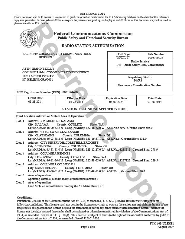
68 66
69 67
70 68
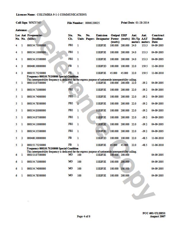
71 69
72 70
73 71
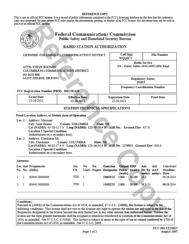
74 72
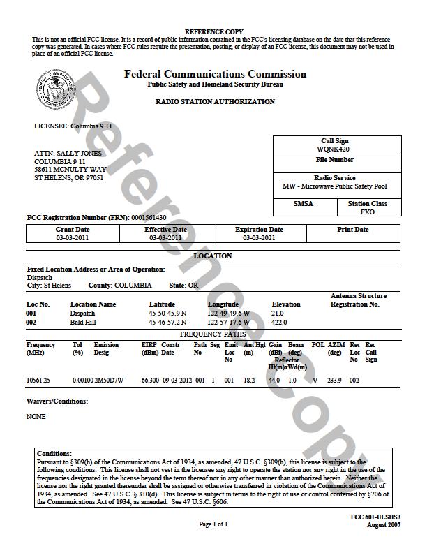
75 73
76 74
77 75
78 76
79 77
80 78
81 79
82 80
83 81
84 ATTACHMENT B TERRAIN PROFILES 82


85 Clatskanie to Northeast Tower Hwy 47 Clatskanie Hwy 30 Clatskanie to Northwest Tower Hwy 30 83


86 Clatskanie to Southeast Tower Hwy 47 Hwy 47 Clatskanie to Southwest Tower Hwy
87 Columbia Heights to Southwest Tower WA Rte Hwy 30 Columbia Heights to Southeast Tower Hwy 30 85


88 Corey Hill to Northeast Tower Nehalem Road Corey Hill to the South Tower Nehalem Road Nehalem Road 86

89 Corey Hill to Southwest Tower Timber Road Timber Road Bald Hill to East Tower Scappoose Vernonia Hwy Hwy 30 87


90 Bald Hill to North Tower Scappoose Vernonia Hwy Bald Hill to Northwest Tower Scappoose Vernonia Hwy 88


91 Bald Hill to Southeast Tower Hwy 30 Bald Hill to South Tower Dutch Canyon 89


92 Bald Hill to Southwest Tower St. Helens to North-Northwest Tower Hwy 30 90


93 St. Helens to South Tower Hwy 30 St. Helens to West Cater Road Tower 91
94 Green Mountain to Northwest Tower Hwy 30 I-5 Green Mountain to Southwest Tower Hwy 30 92
95 Green Mountain to West Tower Fairview Hwy 30 93
96 ATTACHMENT C RADIO SYSTEM COVERAGE MAPS INDIVIDUAL SITES AND ENTIRE SYSTEM The Blue area on each map represents acceptable radio system coverage for talk out from the repeaters to the users and talk back from the users to the repeaters. 94


97 Pallans Associates Columbia Heights Talk Out Columbia Heights Talk Back 95


98 Pallans Associates Clatskanie Talk Out Clatskanie Talk Back 96


99 Corey Hill Talk Out Corey Hill Talk Back 97


100 Bald Hill Talk Out Bald Hill Talk Back 98


101 Green Mountain Talk Out Green mountain Talk Back 99
102 Dispatch Talk Out Dispatch Talk Back 100


103 Scappoose Talk Back Meissner Talk Back 101

104 Pallans Associates Mobile System Wide Talk out

105 Portable System Wide Talk Back 103
Columbia Communications District Request for Information New Radio Communications System
 Columbia 9-1-1 Communications District Request for Information New Radio Communications System Submission Deadline January 2, 2018 1 1 Overview 1.1 Introduction The Columbia 911Communications District
The Professional Consulting Services Communications Consultant E-911. Design Alternatives
 The Communications Consultant E-911 Sullivan County, New York April 21, 2010 Table of Contents 1. OVERVIEW... 4 2. TECHNOLOGY OPTIONS... 5 2.1 Analog Conventional... 5 2.2 Project 25 Conventional... 5
Resource Review and Design Recommendations Public Safety Communications System Assessment and Design. Broome County, New York.
 Resource Review and Design Recommendations Public Safety Communications System Assessment and Design Broome County, New York Report June 28, 2012 Table of Contents 1 Overview... 5 2 System Design... 6
CONCEPTS TO OPERATIONS, INC.
 CHANNEL 16 PROJECT Presented by CONCEPTS TO OPERATIONS, INC. E-mail: cto@concepts2ops.com Web Site: www.concepts2ops.com APCO International Annual Conference Denver, Colorado Professionals Putting Good
Clark County Fire Prevention Las Vegas Nevada
 Clark County Fire Prevention Las Vegas Nevada PUBLIC SAFETY/FIRST RESPONDER RADIO AMPLIFICATION SYSTEMS SCOPE: This guideline sets forth requirements for the design, installation and testing of Public
EMERGENCY COMMUNICATIONS
 EMERGENCY COMMUNICATIONS FY2004-2010 1. BACKGROUND ISSUES The Emergency Communications element of the capital plan is comprised of three projects concerning emergency radio communications, computer aided
Radio Frequency Engineering Report. Proposed Raymond, ME Cellular Facility
 Radio Frequency Engineering Report Proposed, ME Cellular Facility (Site No.: 3462 ) May 12, 2010 C Squared Systems, LLC 920 Candia Road Manchester, NH 03109 Phone: (603) 657-9702 Fax: (603) 657-9707 Support@csquaredsystems.com
FIXED MOUNT DVRS INDOOR/OUTDOOR APPLICATION NOTE. March 2016 Version 4
 FIXED MOUNT DVRS INDOOR/OUTDOOR APPLICATION NOTE March 2016 Version 4 CONTENTS APPLICATION NOTE Introduction...2 Trunking Systems...2 The Need for Coverage...2 The Challenge...3 FDVR Solution...3 Other
Sudden Valley RF Documentation
 Network Engineering Verizon Wireless 3305 160th Ave. SE M/S 231 Bellevue, WA 98008 Sudden Valley RF Documentation Overview: Verizon Wireless strives to provide excellent wireless service for our customers
Whitman County WA Simulcast Systems. Steve Krigbaum Communication Systems Manager Whitman County
 Whitman County WA Simulcast Systems Steve Krigbaum Communication Systems Manager Whitman County Whitman County is budget limited Whitman County has 2,200 square miles and a population of only 47 thousand,
 EXHIBIT 2 Page 1 of 5 Reasonable Necessity for Eminent Domain Action Tuttle Property Final Report PREPARED JANUARY 2018 FOR BROWARD COUNTY, FLORIDA MissionCriticalPartners.com State College Office 690
City of Irvine California Signal Booster Ordinance
 City of Irvine California Signal Booster Ordinance CHAPTER 6. PUBLIC SAFETY RADIO SYSTEM COVERAGE Sec. 5-9-601. Intent and purpose. The intent of the chapter is to provide a regulatory framework for the
CITY AND COUNTY OF DENVER POLICY DENVER FIRE DEPARTMENT. Emergency Responder Radio Enhancement Coverage System (RES)
") Reference: Denver Fire Code Sections 510 Approved: Manuel Almagure Division Chief, Fire Prevention Division Number: 510-1 Effective Date: February 1, 2018 Page 1 of 8 This Policy 510-1 provides additional
Reference: Denver Fire Code Sections 510 Approved: Manuel Almagure Division Chief, Fire Prevention Division Number: 510-1 Effective Date: February 1, 2018 Page 1 of 8 This Policy 510-1 provides additional
Rulemaking Hearing Rules of the Tennessee Department of Health Bureau of Health Licensure and Regulation Division of Emergency Medical Services
 Rulemaking Hearing Rules of the Tennessee Department of Health Bureau of Health Licensure and Regulation Division of Emergency Medical Services Chapter 1200-12-01 General Rules Amendments of Rules Subparagraph
BOARD OF COUNTY COMMISSIONERS AGENDA ITEM SUMMARY
 8E1 BOARD OF COUNTY COMMISSIONERS AGENDA ITEM SUMMARY PLACEMENT: DEPARTMENTAL PRESET: TITLE: CONSIDERATION FOR PURCHASE OF PUBLIC RADIO SYSTEM AGENDA ITEM DATES: MEETING DATE: 12/8/2015 COMPLETED DATE:
Communications Interoperability- Current Status
 Communications Interoperability- Current Status Stephen Mitchell Abstract Over the past decade, the public-safety community in partnership with local, state, and federal agencies have worked to develop
CHAPTER 10 - PUBLIC SAFETY RADIO SYSTEM COVERAGE INTENT AND PURPOSE DEFINITIONS USE AND OCCUPANCY EXEMPTIONS.
 CHAPTER 10 - PUBLIC SAFETY RADIO SYSTEM COVERAGE 8950 - INTENT AND PURPOSE The intent of the chapter is to provide a regulatory framework for the purpose of providing effective 800 MHz Countywide Coordinated
SAN DIEGO COUNTY MUTUAL AID RADIO PLAN
 ATTACHMENT A SAN DIEGO COUNTY MUTUAL AID RADIO PLAN 1.1 General Mutual aid channels are a critical part of San Diego County's radio system requirements. The San Diego County Mutual Aid Radio Plan will
LIFE SAFETY DIVISION GUIDELINE. Subject: BDA Radio Amplification Checklist Date initiated: Date revised:
 Castle Rock Fire and Rescue Department LIFE SAFETY DIVISION GUIDELINE Subject: BDA Radio Amplification Checklist Date initiated: 02-1-2016 Date revised: Approved: CRFD Richard Auston, Division Chief of
Emergency responder radio coverage in new buildings. California Fire Code Section is hereby amended to read:
 Sunnyvale 2013 Fire Code Section 510 16.52.510. Emergency responder radio coverage. (a) Emergency responder radio coverage in new buildings. California Fire Code Section 510.1 is hereby amended to read:
SECTION EMERGENCY RESPONDER RADIO COVERAGE SYSTEMS
 510.1 Emergency responder radio coverage in new buildings. Approved radio coverage for emergency responders shall be provided within all buildings meeting any one of the following conditions: 1. There
FM Transmission Systems Course
 FM Transmission Systems Course Course Description An FM transmission system, at its most basic level, consists of the transmitter, the transmission line and antenna. There are many variables within these
Information for Digital Antenna System (DAS)/ Bi-Directional Amplification (BDA) Systems
/ Bi-Directional Amplification (BDA) Systems") Information for Digital Antenna System (DAS)/ Bi-Directional Amplification (BDA) Systems (Public Safety/Emergency Responder Radio System) Orange County Sheriff s Department, Communications & Technology
Information for Digital Antenna System (DAS)/ Bi-Directional Amplification (BDA) Systems (Public Safety/Emergency Responder Radio System) Orange County Sheriff s Department, Communications & Technology
County of Richmond Dependable IDAS Solution Meets Current & Future Communication Needs
 County of Richmond: Case Study County of Richmond Dependable IDAS Solution Meets Current & Future Communication Needs A case study prepared by Icom America Inc. Manufacturers of high-performance, award-winning
County of Marin. Application for 700 MHz Frequencies
 County of Marin Application for 700 MHz Frequencies The County of Marin respectfully submits the following application for licensing 700 MHz frequencies in accordance with the Region 6 700 MHz plan. County
INTERNAL AUDIT DIVISION CLERK OF THE CIRCUIT COURT
 INTERNAL AUDIT DIVISION CLERK OF THE CIRCUIT COURT AUDIT OF EMERGENCY COMMUNICATIONS DEPARTMENT INTERGOVERNMENTAL RADIO PROGRAM Ken Burke, CPA* Clerk of the Circuit Court Ex Officio County Auditor Robert
IFERN / IFERN 2 Radio Base Stations for all Wisconsin MABAS Divisions/Counties
 Project Name IFERN / IFERN 2 Radio Base Stations for all Wisconsin MABAS Divisions/Counties Sponsoring Agency MABAS Wisconsin - The Mutual Aid Box Alarm System (known as MABAS) Senate Bill SB 642 was approved
Radio Communications Essentials. Module 9: Narrowbanding Pete Peterson
 Radio Communications Essentials Module 9: Narrowbanding Pete Peterson 1 Topics Why is it Necessary? Who is Affected? Key Deadlines & Exceptions What are the Challenges? Sample Steps to Narrowband Frequently
Butler County Department of Emergency Services. Butler County Radio Project Briefing
 Butler County Department of Emergency Services Butler County Radio Project Briefing Why are we here? Define : What is success = Establish long term solution for Public Safety Land-Mobile Radio FCC Mandate-
ENGINEERING REPORT CONCERNING THE EFFECTS UPON FCC LICENSED RF FACILITIES DUE TO CONSTRUCTION OF THE (Name of Project) WIND PROJECT Near (City, State)
 WIND PROJECT Near (City, State)") ENGINEERING REPORT CONCERNING THE EFFECTS UPON FCC LICENSED RF FACILITIES DUE TO CONSTRUCTION OF THE (Name of Project) WIND PROJECT Near (City, State) for (Name of Company) January 3, 2011 By: B. Benjamin
ENGINEERING REPORT CONCERNING THE EFFECTS UPON FCC LICENSED RF FACILITIES DUE TO CONSTRUCTION OF THE (Name of Project) WIND PROJECT Near (City, State) for (Name of Company) January 3, 2011 By: B. Benjamin
800 System Procedures
 Emergency Button Activation: 800 System Procedures All ACFR radios are equipped with emergency button functionality. When this button is activated by the end-user, an audible alarm and a flashing visual
Guide for Short Term Interoperability
 Oregon State Interoperability Executive Council Guide for Short Term Interoperability Adopted: by the SIEC Technical Committee The Oregon State Interoperability Executive Council (SIEC) and the State of
Wyoming s Statewide Public-Safety Interoperable Radio Communications System WyoLink Frequently Asked Questions (FAQ)
") Wyoming s Statewide Public-Safety Interoperable Radio Communications System WyoLink Frequently Asked Questions (FAQ) Goals... 2 1. What is WyoLink supposed to accomplish?... 2 2. Who will oversee WyoLink
Wyoming s Statewide Public-Safety Interoperable Radio Communications System WyoLink Frequently Asked Questions (FAQ) Goals... 2 1. What is WyoLink supposed to accomplish?... 2 2. Who will oversee WyoLink
Radio Technology Overview. January 2011
 Radio Technology Overview January 2011 Presentation Objectives The objective of this presentation is to: Review terms as related to radio technology Review the challenges facing the City o FCC mandate
Developing the Model
 Team # 9866 Page 1 of 10 Radio Riot Introduction In this paper we present our solution to the 2011 MCM problem B. The problem pertains to finding the minimum number of very high frequency (VHF) radio repeaters
REQUEST FOR COUNCIL DIRECTION ON PLACEMENT OF A RADIO TOWER ON DRAKES PEAK
 Agenda Item No. 9A March 28, 2017 TO: FROM: SUBJECT: Honorable Mayor and City Council Attention: Jeremy Craig, Interim City Manager Dawn Leonardini, Administrative Services Director, Kris Concepcion, Fire
Planning Guidelines. Lightcloud. Best Practices for Installing Lightcloud
 Best Practices for Installing Lightcloud Planning Guidelines Lightcloud Network Wireless Networking Considerations Wireless Mesh Network Placement of Devices Powering Devices Placing the Gateway Installation
Public Safety Radio Bands. VHF Low Band: 25 MHz to 50 MHz VHF High: 138 MHz to 174 MHz UHF: 408 MHz to 512 MHz 700 MHz (new) 800 MHz 4.
 800 MHz 4.") Public Safety Radio Bands VHF Low Band: 25 MHz to 50 MHz VHF High: 138 MHz to 174 MHz UHF: 408 MHz to 512 MHz 700 MHz (new) 800 MHz 4.9 GHz (new) Why is this a problem? Radios only operate in one band!
Public Safety Radio Bands VHF Low Band: 25 MHz to 50 MHz VHF High: 138 MHz to 174 MHz UHF: 408 MHz to 512 MHz 700 MHz (new) 800 MHz 4.9 GHz (new) Why is this a problem? Radios only operate in one band!
MERA NEXT GENERATION SYSTEM SUMMARY PROJECT DESCRIPTION IN ADVANCE OF CEQA SUBSEQUENT ENVIRONMENTAL IMPACT REPORT (SEIR)
") PROJECT SPONSOR AND LEAD AGENCY MERA NEXT GENERATION SYSTEM SUMMARY PROJECT DESCRIPTION IN ADVANCE OF CEQA SUBSEQUENT ENVIRONMENTAL IMPACT REPORT (SEIR) The Marin Emergency Radio Authority (MERA) is a
PROJECT SPONSOR AND LEAD AGENCY MERA NEXT GENERATION SYSTEM SUMMARY PROJECT DESCRIPTION IN ADVANCE OF CEQA SUBSEQUENT ENVIRONMENTAL IMPACT REPORT (SEIR) The Marin Emergency Radio Authority (MERA) is a
Moline Illinois CODE OF ORDINANCES. Art. IX. Miscellaneous DIVISION 3. IN-BUILDING EMERGENCY RADIO SYSTEM COVERAGE
 Moline Illinois CODE OF ORDINANCES Art. IX. Miscellaneous DIVISION 3. IN-BUILDING EMERGENCY RADIO SYSTEM COVERAGE SEC. 8-9300. TITLE. The title of this division shall be the Emergency Radio System Coverage
CLARK COUNTY FIRE CODE AMENDMENTS
 CLARK COUNTY FIRE CODE AMENDMENTS SECTION 510 EMERGENCY RESPONDER RADIO COVERAGE SYSTEM is amended to read as follows: SECTION 510 EMERGENCY RESPONDER RADIO COVERAGE SYSTEM 510.1 Emergency responder radio
47 CFR Ch. I ( Edition)
") 73.684 should decrease more rapidly with distance beyond the horizon than for Channels 2 6, and modification of the curves for Channels 14 69 may be expected as a result of measurements to be made at a
73.684 should decrease more rapidly with distance beyond the horizon than for Channels 2 6, and modification of the curves for Channels 14 69 may be expected as a result of measurements to be made at a
Spencer County IDAS Increases Coverage, Promotes Safety and Future-Proofs Communication for Regional Volunteer Fire Districts and EMS
 Spencer County: Case Study Spencer County IDAS Increases Coverage, Promotes Safety and Future-Proofs Communication for Regional Volunteer Fire Districts and EMS A case study prepared by Icom America Inc.
Guide for Short Term Interoperability Revised June 24, 2009
 Oregon State Interoperability Executive Council Guide for Short Term Interoperability Revised The Oregon State Interoperability Executive Council (SIEC) and the State of Oregon encourage Oregon s public
Sept 28, Mukhtar mook-tar Thakur
 MnDOT Office of Statewide Radio Communications (OSRC) Overview -Summary and ARMER Status Update Central Region Summit- Alexandria, MN Sept 28, 2016 Mukhtar mook-tar Thakur The Office of Statewide Radio
Simulcasting Project 25
 ATLAS Simulcasting Project 25 2013 April Copyright 2012-2013 by EFJohnson Technologies, Inc. The EFJohnson Technologies logo, ATLAS, and StarGate are trademarks of EFJohnson Technologies, Inc. All other
PROJECT NARRATIVE AND ALTERNATIVE ANALYSIS
 PROJECT NARRATIVE AND ALTERNATIVE ANALYSIS 15505 Sand Canyon Avenue Building D-1 Irvine, CA 92618 May 23, 2011 Subject: Verizon Wireless Proposed Cordillera Telecommunications Facility Located at 4515
Wireless Facility Peer Engineering Review
 Page 1 of 11 Wireless Facility Peer Engineering Review Regarding Verizon Wireless Application 2750 Dwight Way, Berkeley, CA August 10, 2015 Page 2 of 11 Introduction RCC Consultants, Inc. has been engaged
Simulcast Radio Network Design. Jay M. Jacobsmeyer, P.E. Pericle Communications Co Vindicator Drive, Suite 100 Colorado Springs, CO 80919
 Simulcast Radio Network Design Jay M. Jacobsmeyer, P.E. Pericle Communications Co. 1910 Vindicator Drive, Suite 100 Colorado Springs, CO 80919 Outline Company Overview Background Information Needs Analysis
SOLUTIONS Paper Wi4 Fixed: Point-to-Point Wireless Broadband Solutions. Point-to-Point Connectivity in the 4.9 GHz Public Safety Band
 SOLUTIONS Paper Wi4 Fixed: Point-to-Point Wireless Broadband Solutions Point-to-Point Connectivity in the 4.9 GHz Public Safety Band Contents pg Section 3 FCC and the Public Safety RF Band 3 Qualified
Verizon Wireless Proposed Base Station (Site No Lake Cachuma ) 2680 Highway 154 Santa Barbara County, California
 2680 Highway 154 Santa Barbara County, California") Statement of Hammett & Edison, Inc., Consulting Engineers The firm of Hammett & Edison, Inc., Consulting Engineers, has been retained on behalf of Verizon Wireless, a personal wireless telecommunications
Statement of Hammett & Edison, Inc., Consulting Engineers The firm of Hammett & Edison, Inc., Consulting Engineers, has been retained on behalf of Verizon Wireless, a personal wireless telecommunications
Modeling Electromagnetic Radiation on Lookout Mountain, Colorado
 Modeling Electromagnetic Radiation on Lookout Mountain, Colorado 1. Introduction 1.1. Goal of Research This Capstone project has been initiated in an attempt to model the Electromagnetic Radiation (EMR)
Radiocommunication Facility Review Protocol
 Radiocommunication Facility Review Protocol 1.0 PURPOSE 1.1 The purpose of this protocol is to outline the guidelines and review process through which Radiocommunication Facilities are evaluated within
NXDN Signal and Interference Contour Requirements An Empirical Study
 NXDN Signal and Interference Contour Requirements An Empirical Study Icom America Engineering December 2007 Contents Introduction Results Analysis Appendix A. Test Equipment Appendix B. Test Methodology
Proposed Action Hutch Mountain Communications Site Coconino National Forest June 2016
 Proposed Action Hutch Mountain Communications Site Coconino National Forest June 2016 PURPOSE AND NEED The proposed Hutch Mountain Communications Site project is part of a broader wireless industry strategy
Frequently Asked Questions about Wireless Facilities on Wooden Utility Poles and Streetlight Poles
 City Hall 10300 Torre Avenue Cupertino, CA 95014-3255 PH: (408) 777-3354 FX: (408) 777-3333 PUBLIC WORKS DEPARTMENT Frequently Asked Questions about Wireless Facilities on 1. What is a small cell facility?
Town of Norwich, VT Radio Communications Study
 Town of Norwich, VT Radio Communications Study October 22, 2010 Report on Findings, Conceptual Design, and Recommendations Prepared by Communications Design Consulting Group Page 1 of 27 Table of Contents
APCO Technology Forum THE CONVERGENCE OF WIRELESS COMMUNICATIONS IN PUBLIC SAFETY. Andrew M. Seybold
 APCO Technology Forum THE CONVERGENCE OF WIRELESS COMMUNICATIONS IN PUBLIC SAFETY Andrew M. Seybold February 26, 2014 Some Terminology NPSBN Nationwide Public Safety Broadband Network LMR Land Mobile Radio
Alaska Land Mobile Radio Communications System. Radio Concepts
 A FEDERAL, STATE AND MUNICIPAL PARTNERSHIP Alaska Land Mobile Radio Communications System Radio Concepts Overview Radio Concept Review Types of Radios Systems Conventional System Trunked System ALMR Zones
Adjacent Channel Studies in the FM Band
 Adjacent Channel Studies in the FM Band Prepared for the NRSC By ibiquity Digital Corporation 11/09/00 Adjacent Channel Studies in the FM Band Page 1 As part of its AM IBOC development effort, ibiquity
Boundary County Simulcast System Presentation March 22, 2015
 Page 1 Introduction: Slide 2 Boundary County is the northern most county in Idaho. It shares an international border with Canada to the north. The total county population is only 10,800 in an area of 1278
ESF 2. Communications
 ESF 2 Communications This page left blank intentionally. 1 Introduction: Purpose and Scope ESF 2 organizes, establishes, and maintains the communications capabilities among appropriate agencies/entities
Optimizing 16 db Capture Effect to Overcome Class A 'Channelized' Signal Booster Group Delay problems within Public Safety Communications Systems
 Optimizing 16 db Capture Effect to Overcome Class A 'Channelized' Signal Booster Group Delay problems within Public Safety Communications Systems July 30, 2008 2008 Jack Daniel Company 2008 Jack Daniel
Wireless Facility Engineering Review
 Page 1 of 7 Wireless Facility Engineering Review AT&T Application for Site (CNU 4989) 2095 Rose Street, Berkeley, CA 2/18/2013 RCC Consultants, Inc. Western Regional Office 266 E. 33 rd Street, San Bernardino,
RF Report. Proposed Wireless Facility. BS13XC Main Street, Cotuit, MA 02635
 C Squared Systems, LLC 65 Dartmouth Drive Auburn, NH 03032 Phone: (603) 644 00 support@csquaredsystems.com RF Report Proposed Wireless Facility 414 Main Street, Cotuit, MA 02635 August 17, 2017 TABLE OF
Lincoln County Fire and Rescue Association Standard Operating Guideline (SOG)
") Number: 113 Title: Fire Dispatch Guidelines Purpose: To provide an overview of communications guidelines for fire and rescue departments. 1. Radio Etiquette All Radio users shall comply with all pertinent
Number: 113 Title: Fire Dispatch Guidelines Purpose: To provide an overview of communications guidelines for fire and rescue departments. 1. Radio Etiquette All Radio users shall comply with all pertinent
Wind Power GeoPlanner. Land Mobile & Emergency Services Report
 Prepared on Behalf of Wind LLC February 27, 2015 Wind LLC Table of Contents 1. Introduction - 1-2. Summary of Results - 2-3. Impact Assessment - 8-4. Recommendations - 8-5. Contact - 9 - Comsearch Proprietary
SECTION 35 ANTENNAS AND TOWERS
 SECTION 35 ANTENNAS AND TOWERS Section: 515-35-1 Purpose and Intent 515-35-2 General Standards 515-35-3 Certification, Inspection and Maintenance 515-35-4 Tower Design 515-35-5 Co-Location Requirement
DCC Trunked Radio System Proposer Questions and Answers, rev 2 September 28, 2011
 Proposer questions are in Times New Roman plain text. Answers to proposer questions are in Times New Roman italics. General Q1. RFP Extension. Due to the large number of Buildings requiring In-Building
SUBJECT: MARIN EMERGENCY RADIO AUTHORITY (MERA) NEXT GENERATION
 NEXT GENERATION") STAFF REPORT MEETING DATE: August 20, 2013 TO: City Council 75 Rowland Way #200 Novato, CA 94945-3232 (415) 899-8900 FAX (415) 899-8213 www.novato.org FROM: James Berg, Chief of Police SUBJECT: MARIN EMERGENCY
STAFF REPORT MEETING DATE: August 20, 2013 TO: City Council 75 Rowland Way #200 Novato, CA 94945-3232 (415) 899-8900 FAX (415) 899-8213 www.novato.org FROM: James Berg, Chief of Police SUBJECT: MARIN EMERGENCY
amplification: The process of increasing the strength of a radio signal.
 GLOSSARY OF RADIO TERMS: The following is a compilation of terms and acronyms Law Enforcement officials often times hear. This information was collected from several sources. It should be used as a guide
Public Safety Radio Communication Project
 Public Safety Radio Communication Project October 2008 Section 1: Executive Summary... 1-1 Section 2: Agency Review... 2-1 Introduction... 2-1 System Coverage... 2-5 Radio System Inventory... 2-14 System
VOLUSIA COUNTY SHERIFF S OFFICE FIRE/EMS COMMUNICATIONS CENTER
 VOLUSIA COUNTY SHERIFF S OFFICE FIRE/EMS COMMUNICATIONS CENTER COMMUNICATIONS POLICIES AND PROCEDURES POLICY# C-01.01 SUBJECT: RADIO INFORMATION ISSUING AUTHORITY: RESCINDS: 07 SEPTEMBER 2002 DATE ISSUED:
Steven W. Jennings, CIO Harris County ITC
 Steven W. Jennings, CIO Harris County ITC Harris County operates an 800 MHz Motorola Multi-cast SmartZone Regional Radio System that supports 33,000 users in 512 departments in the region, covering nine
PALMETTO 800 History Project Cost
 PALMETTO 800 South Carolina has implemented the largest statewide emergency communications radio system in the nation. With over twenty thousand users, the system is available to federal, state, and local
AT&T Mobility Proposed Base Station (Site No. CN4779A) 1101 Keaveny Court Walnut Creek, California
 1101 Keaveny Court Walnut Creek, California") Statement of Hammett & Edison, Inc., Consulting Engineers The firm of Hammett & Edison, Inc., Consulting Engineers, has been retained on behalf of AT&T Mobility, a personal wireless telecommunications
Statement of Hammett & Edison, Inc., Consulting Engineers The firm of Hammett & Edison, Inc., Consulting Engineers, has been retained on behalf of AT&T Mobility, a personal wireless telecommunications
MEMA Narrowbanding Planning Primer
 1. The State of Maine is required to narrowband its public safety communications radios, as are all county and local governments, in accordance with the Federal Communications Commission (FCC) mandate,
Glossary of Terms Black Sky Event: Blue Sky Operations: Federal Communications Commission (FCC): Grey Sky Operations:
: Grey Sky Operations:") Glossary of Terms The following is a list of terms commonly used in the electric utility industry regarding utility communications systems and emergency response. The purpose of this document is to provide
Glossary of Terms The following is a list of terms commonly used in the electric utility industry regarding utility communications systems and emergency response. The purpose of this document is to provide
Project Recaps Fond du Lac County and Adams County Wisconsin Lessons Learned Steve Dubberstein President, Communications Service Inc.
 www.rfstore.com Project Recaps Fond du Lac County and Adams County Wisconsin Lessons Learned Steve Dubberstein President, Inc. Simulcast Forum XV Las Vegas, Nevada March 10, 2011 305 East Albert Street
Public Safety Communications Systems Engineering and Consulting
 Public Safety Communications Systems Engineering and Consulting NAPCO September 13, 2012 MichaelKenned Kennedy Western Regional Manager Brian Malinich, PE Sr. Consultant Project Highlights / Lessons Learned
TAP 6 Demo Quick Tour
 TAP 6 Demo Quick Tour Sales Contact: Curt Alway P.O. Box 7205 Charlottesville, VA 22906 Voice: 303-344-5486, Ext 1 Fax: 303-265-9399 Email: sales@softwright.com Technical Contact: Todd Summers, Ph.D. P.O.
TRAINING BULLETIN. EFFECTIVE DATE: 05/06 DOC NO: TB198 CROSS REF: Communications Checklists
 INTRODUCTION Communications Support 131 (CS131) is an important asset of the District and plays a significant role in the county and region. The unit has many communications assets, including radios on
LMS4000 & NCL MHz Radio Propagation
 LMS4000 & NCL1900 900-MHz Radio Propagation This application note is an update to the previous LMS3000/LMS3100 900 MHz Radio Propagation note. It provides general guidelines to estimate CCU3000 & NCL1900
2-800 MHz CCCS Sys Extension
 2-800 MHz CCCS Sys Extension 1. Program Area: PUBLIC PROTECTION 2. Identify agencies and departments involved. Sheriff-Coroner. 3. Is the Strategic Priority new or previously identified in an earlier Strategic
FDOT Upgrades for Interoperability
 Images courtesy Florida Department of Transportation FDOT Upgrades for Interoperability The Florida Department of Transportation (FDOT) has used low-band VHF analog radios operating between 45 and 47 MHz
IDK Communications ( IDK ) has been tasked with the following scope pertaining to the above referenced subject.
 has been tasked with the following scope pertaining to the above referenced subject.") IDK Communications April 27, 2017 Mr. Ethan J. Croce Senior Planner Town of Falmouth 271 Falmouth Road Falmouth, ME 04105 RE: Verizon Application 175 Falmouth Road Dear Mr. Croce, IDK Communications (
IDK Communications April 27, 2017 Mr. Ethan J. Croce Senior Planner Town of Falmouth 271 Falmouth Road Falmouth, ME 04105 RE: Verizon Application 175 Falmouth Road Dear Mr. Croce, IDK Communications (
Costa Mesa California
 Costa Mesa California Section 1. Title 5 of the Costa Mesa Municipal Code entitled Building and Structures, is hereby amended to add Chapter IX, entitled INBUILDING PUBLIC SAFETY RADIO SYSTEM COVERAGE
Public Safety Communications Commission
 Public Safety Communications Commission Report to Governor and Joint Transportation, Highways and Military Affairs Committee June 2017 Matthew H. Mead Governor Wyoming Public Safety Communications Commission
Multi Agency Communications Center
 Multi Agency Communications Center Public Safety Radio System Replacement Request For Proposal ADDENDUM 2 October 26, 2010 Prepared by Multi Agency Communications Center 6500 32 nd Avenue NE, Suite 911
WASHINGTON COUNTY-WIDE Digital Trunked P25 Phase 2 Interoperable EMERGENCY RADIO, PAGING & SYSTEM for sheriff, police, fire
 2018-2019 WASHINGTON COUNTY-WIDE Digital Trunked P25 Phase 2 Interoperable EMERGENCY RADIO, PAGING & 9-1-1 SYSTEM for sheriff, police, fire departments ems first responders & ambulance Operating from a
Safety Code 6 (SC6) Measurement Procedures (Uncontrolled Environment)
 Measurement Procedures (Uncontrolled Environment)") February 2011 Spectrum Management and Telecommunications Technical Note Safety Code 6 (SC6) Measurement Procedures (Uncontrolled Environment) Aussi disponible en français NT-329 Contents 1.0 Purpose...1
February 2011 Spectrum Management and Telecommunications Technical Note Safety Code 6 (SC6) Measurement Procedures (Uncontrolled Environment) Aussi disponible en français NT-329 Contents 1.0 Purpose...1
Three-Question Matrix and Reference Checks. RFP Number: R P1 RFP Name: Public Safety Radio APCO Project MHz Communication System
 Page 1 of 36 Three-Question Matrix and Reference Checks RFP Number: R1422515P1 RFP Name: Public Safety Radio APCO Project 25 700MHz Communication System Ranking (Not Alphabetical) 1 2 Firm Name Motorola
Initial Comments on DRI Application for Wakeby Road Cell Tower September 26, 2017
 Thinking outside the sphere Initial Comments on DRI Application for Wakeby Road Cell Tower September 26, 2017 The Cape Cod Commission ( Commission ) is hearing an application for DRI review of a proposed
MINIMIZING SITE INTERFERENCE
 MINIMIZING SITE INTERFERENCE CHAPTER 8 This chapter provides information on preventing radio frequency (RF) interference at a communications site. The following topics are included: Interference Protection
SOLUTIONS Paper Wi4 Fixed: Point-to-Point Wireless Broadband Solutions. Point-to-Point Connectivity in the 4.9 GHz Public Safety Band
 SOLUTIONS Paper Wi4 Fixed: Point-to-Point Wireless Broadband Solutions Point-to-Point Connectivity in the 4.9 GHz Public Safety Band Contents pg Section 3 FCC and the Public Safety RF Band 3 Qualified
FINAL REPORT SUBMITTED JUNE 2017 TO: SHENANDOAH COUNTY, VIRGINIA
 Radio System Needs Assessment FINAL REPORT SUBMITTED JUNE 2017 TO: SHENANDOAH COUNTY, VIRGINIA TABLE OF CONTENTS EXECUTIVE SUMMARY... 1 1. INTRODUCTION... 6 2. METHODOLOGY... 6 2.1. INITIAL MEETING...
Mosier Fire & Emergency Services Standard Operating Procedure Communications
 Mosier Fire & Emergency Services Standard Operating Procedure Communications 1. Objectives This Operating Procedure describes the use, maintenance and procedures for communications in emergency and non-emergency
Satellite Video Transmission and the Analog to Digital Conversion Process
 Satellite Video Transmission and the Analog to Digital Conversion Process By Gary Edwards The changing frontier for television broadcasters and cable television providers includes the conversion from analog
Eaton County Public Safety Radio System Recommendation
 Eaton County Public Safety Radio System Recommendation AUGUST 1, 2017 EATON COUNTY CENTRAL DISPATCH RADIO SYSTEM ADVISORY WORKGROUP TABLE OF CONTENTS Executive Summary... 3 Overview of the Radio System
Wind Power GeoPlanner. Land Mobile Report - UPDATE
 Prepared on Behalf of Iberdrola Renewables, LLC December 13, 2012 Table of Contents 1. Introduction - 1-2. Summary of Results - 1-3. Impact Assessment - 3-4. Conclusions - 4-5. Recommendations & Mitigation