Cotton Belt Corridor. Area Focus Group (AFG) Carrollton/Addison August 29, John Hoppie, Capital Planning
|
|
|
- Geoffrey Stewart
- 6 years ago
- Views:
Transcription

1 Cotton Belt Corridor Area Focus Group (AFG) Carrollton/Addison August 29, 2017 John Hoppie, Capital Planning 0
2 Agenda Design Update Alignment/Cross-section/Stations/Facilities Environmental Update Documentation of Existing Conditions Traffic Update Arapaho Bridge Ridership Community Integration Community Open Houses 1
3 2
4 Design Update: Engineering Revised Drawings: (Double Track Scenario) Horizontal alignment Vertical alignment Typical sections Downtown Carrollton Facilities Mercer Yard Equipment Maintenance Facility 3
5 4
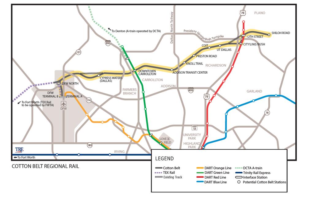
6 5
7 6
8 Downtown Carrollton 7
9 Design Update: Stations Revised Station Location and Length (350-foot) Side Platform Concept Center Platform Concept Conceptual Architectural Rendering Station Plan Views 8
10 Design Update: Stations 9
11 Design Update: Stations 10
12 Design Update: Stations 11
13 Focus Area Stations 12

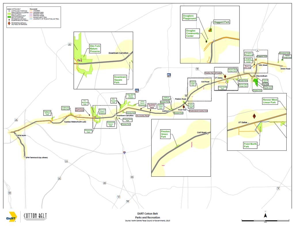
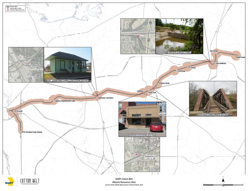
14 Downtown Carrollton Station 13


15 Addison Station 14
16 Cotton Belt Facilities 15

17 Equipment Maintenance Facility (EMF) 16

18 Equipment Maintenance Facility (EMF) 17

19 Relocated Mercer Yard 18

20 Relocated Mercer Yard 19
21 Environmental Update Documentation of Existing Conditions Land Use Parks and Recreation Vegetation and Waters Resources Historic Resources 20
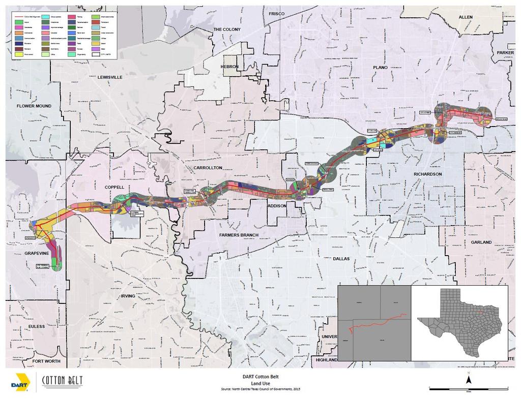
22 21
23 22
24 23
25 24
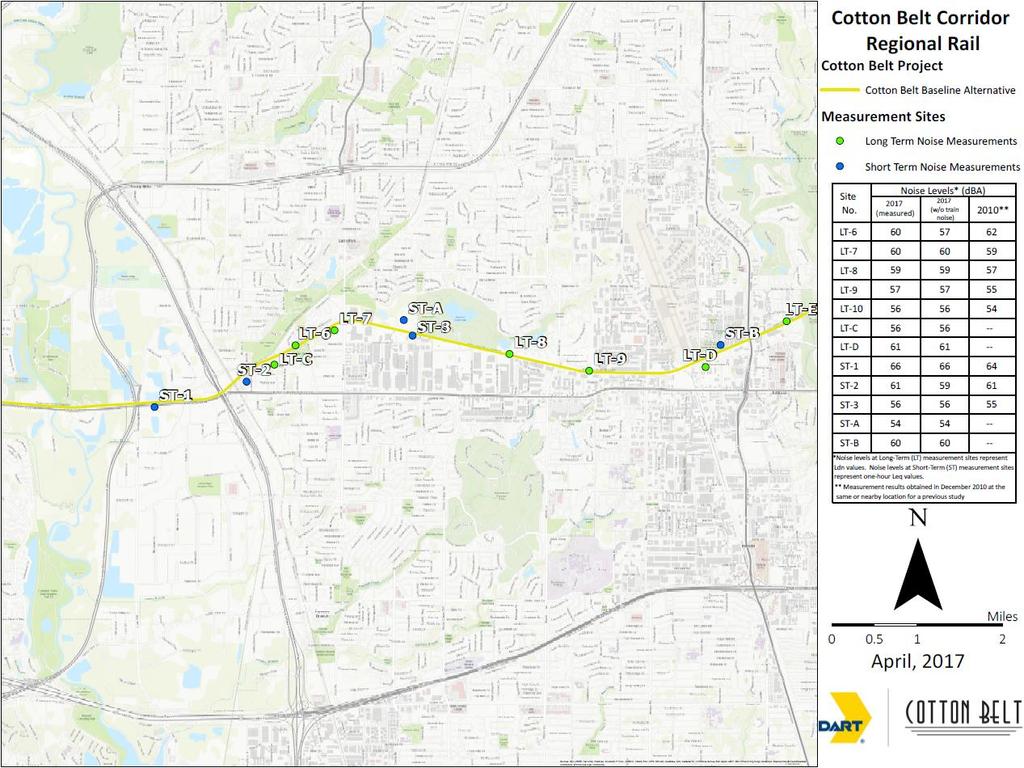
 noise measurements along the corridor.")
26 Noise Methodology A noise monitoring program has been initiated to characterize the existing noise conditions at representative noise-sensitive receptors along the Cotton Belt Corridor. Noise Monitors* were installed at 27 locations to collect long-term (24- hour) noise measurements along the corridor. Noise Monitors* were installed at 11 locations to measure short-term noise (1 hour). *Noise Monitors were NTi Audio model XL2 that conform to American National Standards Institute (ANSI) Standard S1.4 for Type 1 (Precision) sound level meters 25
27 26
28 Noise - Next Phase Assessment Identification of Impacts (Per FTA Criteria) Recommend Mitigation Generally Quiet Zones will be recommend along the most of the corridor 27
29 2010 Proposed Grade Separations 28
30 2017 Crossings Requiring Mitigation 29
31 Traffic Update STREET CROSSING LOCATION (Carrollton/Addison AFG) CITY ANALYSIS RESULTS Addison Road Midway Road Marsh Lane Luna Road Addison Addison Addison Carrollton The northbound queue length extends beyond Arapaho Road during the pm peak hour and the southbound queue length extends beyond Lindbergh Road during the am peak hour. Aeronautical and physical constraints to grade separation. Analysis reconfirms need for grade separation of Midway Road.. The northbound queue length extends beyond Arapaho Road during the pm peak hour and the southbound queue length extends beyond Country Square Drive during the am peak hour. The northbound queue length extends beyond the PGB Turnpike Exit Ramp intersection during the evening peak hour and the southbound queue length extends beyond the PGB Turnpike Exit/Entrance Ramps intersection during the morning peak hour. Physical constraints to grade separation. MITIGATION REQUIRED * Yes Yes Yes Yes *Mitigations could include: Signal synchronization, intersection improvements adding capacity, or grade separation 30

32 Midway Grade Separation 31

33 Midway Grade Separation 32

34 Arapaho Bridge 33
35 Cotton Belt Bridge (No Arch) 34
36 Cotton Belt Bridge (Arch) 35

 36")
37 Cotton Belt Bridge (Arch) 36

38 Cotton Belt Bridge (No Arch) 37
39 Cotton Belt Ridership DAILY RIDERSHIP STATION NAME Opening Day 2040 DFWIA AB Terminal Station 1,200 1,200 North DFW Station 800 1,300 Cypress Waters Station Downtown Carrollton Station 1,000 2,000 Addison Station 1,000 1,700 Knoll Trail Station Preston Rd Station Coit Rd Station UT Dallas Station CityLine/Bush Station 1,000 1,400 12th Street Station Shiloh Station Total 7,900 12,200 38
40 Community Integration Community Integration features such fences, walls, trails, landscaping, etc. will be incorporated into the project subsequent to identification of impacts and required mitigation. DART will work in cooperation with NCTCOG and local jurisdictions for implementation community integration features. 39
41 Sound Walls Sound Walls: Noise impact analysis will determine where walls are required. DART will work in cooperation with local jurisdictions for consideration of additional walls 40
42 Trails Trails: DART will work in cooperation with NCTCOG and local jurisdictions for implementation of trails along corridor 41

43 Cotton Belt Regional Trail (NCTCOG) 42
44 Open Houses Monday, September 18, 2017, 6:30 p.m. DeWitt Perry Middle School Cafeteria 1709 East Belt Line Road, Carrollton, TX (Parking and entrance off Warner Street) Wednesday, September 20, 2017, 6:30 p.m. Richardson Civic Center 411 West Arapaho Road, Richardson, TX Monday, September 25, 2017, 7:00 p.m. Parkhill Junior High School Cafeteria Shady Bank Drive, Dallas, TX

45 44 44
State Road A1A North Bridge over ICWW Bridge
 Final Report State Road A1A North Bridge over ICWW Bridge Draft Design Traffic Technical Memorandum Contract Number: C-9H13 TWO 5 - Financial Project ID 249911-2-22-01 March 2016 Prepared for: Florida
Appendix D. Traffic Noise Analysis Report. I-94 St. Michael to Albertville Minnesota Department of Transportation
 Appendix D Traffic Noise Analysis Report I-94 St. Michael to Albertville Minnesota Department of Transportation Traffic Noise Analysis Report I-94 St. Michael to Albertville Project SP 8680-172 Report
Northwest Rail Corridor Update
 Northwest Rail Corridor Update Governments Team February 13, 2009 1 Meeting Agenda 1. Program Updates 1. RTD FasTracks Program Update 2. Annual Program Evaluation 2. NWR EE Updates 1. New USACE Representative
The Shoppes at Forney Crossings
 F M 548 U.S. HWY 80 U.S. HWY 80 F M 688 F M 548 COOL SPRINGS F M 1641 F M 548 TROPHY BUGLE CALL PHESANT WHITE PORCH SPINAKER The Shoppes at Forney Crossings 18' 14'-8" 18' 15'-8 1 2 " 14' 7' 23'-0" 21'-0"
Exit 61 I-90 Interchange Modification Justification Study
 Exit 61 I-90 Interchange Modification Justification Study Introduction Exit 61 is a diamond interchange providing the connection between Elk Vale Road and I-90. Figure 1 shows the location of Exit 61.
Update on Traffic Results and Findings
 Los Angeles County Metropolitan Transportation Authority Update on Traffic Results and Findings presented to the Corridor Advisory Committee February 16, 2017 Traffic Presentation Topics 2 Traffic Volumes
Appendix G. Visual Simulations and Illustrations
 Appendix G Visual Simulations and Illustrations 5TH AVE AV E N View ewshe ed 5 SHORELINE N 185TH ST egment B gment A 26 NE 185th Street Station (A1, A3, A5, A7, A10, A11) 25 24 23 22 21 NE 180TH ST 99
Move In Directions for First-year and Transfer Students Douglass Campus Gibbons Residence Hall A & B
 Move In Directions for First-year and Transfer Students Douglass Campus Gibbons Residence Hall A & B General Instructions: Print directions and name of assigned building. Place the name of your residence
PUBLIC HEARING LOOP 375 FRONTAGE ROADS RECONFIGURATION FROM FM 76 (NORTH LOOP DRIVE) TO ZARAGOZA PORT OF ENTRY CSJ: EL PASO COUNTY, TEXAS
 TO ZARAGOZA PORT OF ENTRY CSJ: EL PASO COUNTY, TEXAS") PUBLIC HEARING LOOP 375 FRONTAGE ROADS RECONFIGURATION FROM FM 76 (NORTH LOOP DRIVE) TO ZARAGOZA PORT OF ENTRY CSJ: 2552-03-058 EL PASO COUNTY, TEXAS Del Valle High School July 25, 2018 Hearing Information
PUBLIC HEARING LOOP 375 FRONTAGE ROADS RECONFIGURATION FROM FM 76 (NORTH LOOP DRIVE) TO ZARAGOZA PORT OF ENTRY CSJ: 2552-03-058 EL PASO COUNTY, TEXAS Del Valle High School July 25, 2018 Hearing Information
Appendix L Noise Technical Report. Rehabilitation and Restoration of the Longfellow Bridge
 Appendix L Noise Technical Report Rehabilitation and Restoration of the Longfellow Bridge Noise Technical Report Rehabilitation and Restoration of the Longfellow Bridge Boston, MA May, 2011* Prepared by
Appendix B: Noise Study
 Appendix B: Noise Study creating remarkable solutions for a higher quality of life NOISE STUDY Interstate 55 Route PP to County Road 311 Prepared for: MoDOT PROJECT NO. J010956 November 2014 Prepared
Article 4.0 Measurements and Exceptions
 This Article identifies and explains some of the more common forms of measurement used throughout this Ordinance. It also specifies exceptions to certain requirements of this Ordinance. Sec. 4.1 Measurements
Currently 2 vacant engineer positions (1 Engineer level, 1 Managing Engineer level)
") INDOT Agency Factoids (System/Comm.) Number of signalized intersections- 2570 200 connected by fiber 300 connected by radio 0 connected by twisted pair 225 connected by cellular 1500 not connected to communication
INDOT Agency Factoids (System/Comm.) Number of signalized intersections- 2570 200 connected by fiber 300 connected by radio 0 connected by twisted pair 225 connected by cellular 1500 not connected to communication
FARM TO MARKET 1103 OPEN HOUSE PUBLIC MEETING. FM 1103 I-35 to Rodeo Dr
 FARM TO MARKET 1103 OPEN HOUSE PUBLIC MEETING March 29, 2016 FM 1103 FROM: I-35 TO: RODEO DR COMAL & GUADALUPE COUNTY OPEN HOUSE PUBLIC MEETING March 29, 2016 5:00 p.m. 7:00 p.m. Barbara C Jordan Intermediate
Attachment #2 PPW133-07
 Attachment #2 PPW133-07 Pg. 1 EXECUTIVE SUMMARY Environmental Assessment Study In January 2005, Regional staff retained to commence a Schedule C Environmental Assessment Study to identify the improvements
TRAFFIC IMPACT STUDY. PROPOSED AMENDED MASTER PLAN AMENDED - H - ZONE Village of Ridgewood Bergen County, New Jersey
 TRAFFIC IMPACT STUDY PROPOSED AMENDED MASTER PLAN AMENDED - H - ZONE Village of Ridgewood Bergen County, New Jersey Prepared For: The Valley Hospital 223 North Van Dien Avenue Ridgewood, New Jersey 07450
APPLICATION FOR ZONING AND LAND DEVELOPMENT
 APPLICATION FOR ZONING AND LAND DEVELOPMENT To be completed by Town staff: Application date: Application/Fee Received: Fee Paid: TYPE OF APPLICATION (CHECK ALL THAT APPLY) ZONING DEVELOPMENT PLANS Zoning
Memorandum 1.0 Highway Traffic Noise
 Memorandum Date: September 18, 2009 To: Chris Hiniker, SEH From: Stephen B. Platisha, P.E. Re: Updated CSAH 14 Noise Analysis The purpose of this memorandum is to provide the results of the revised traffic
Site Plan Review Application. Interest in the Property (e.g. fee simple, land option, etc.)
") 1. Identification CITY OF FENTON 301 South Leroy Street Fenton, Michigan 48430-2196 (810) 629-2261 FAX (810) 629-2004 Site Plan Review Application Project Name Applicant Name Address City/State/Zip Phone
1. Identification CITY OF FENTON 301 South Leroy Street Fenton, Michigan 48430-2196 (810) 629-2261 FAX (810) 629-2004 Site Plan Review Application Project Name Applicant Name Address City/State/Zip Phone
Noise Mitigation Study Pilot Program Summary Report Contract No
 Ohio Turnpike Commission Noise Mitigation Study Pilot Program Summary Report Contract No. 71-08-02 Prepared For: Ohio Turnpike Commission 682 Prospect Street Berea, Ohio 44017 Prepared By: November 2009
Agenda. Analysis Tool Selection and Mesoscopic Dynamic Traffic Assignment Models Applications:
 Four Case Studies Agenda Analysis Tool Selection and Mesoscopic Dynamic Traffic Assignment Models Applications: Traffic diversion caused by capacity reduction (Fort Lauderdale, FL) Impacts on traffic due
City of San José, California CITY COUNCIL POLICY
 City of San José, California CITY COUNCIL POLICY TITLE 1 1 of 6 EFFECTIVE DATE 1/22/91 REVISED DATE 9/16/03 APPROVED BY Council Action - January 22, 1991; August 11, 1992; August 20, 1996 (9d); September
REGIONAL TRANSIT AUTHORITY RESOLUTION NO BACKGROUND AND COMMENTS. Agenda Item: No. 4. No. 7C-1
 REGIONAL TRANSIT AUTHORITY RESOLUTION NO. 98-1 BACKGROUND AND COMMENTS Meeting: PGA Committee Board of Directors Date: 1/16/98 1/22/98 Agenda Item: No. 4 No. 7C-1 Staff Contact: Barbara Dougherty, Communications
APPLICATION FOR PLANNED UNIT DEVELOPMENT (PUD) DEVELOPMENT PLAN
 DEVELOPMENT PLAN") 209 S. Main Street Marysville, Ohio 43040 Phone: (937) 645-7350 Fax: (937) 645-7351 www.marysvilleohio.org APPLICATION FOR PLANNED UNIT DEVELOPMENT (PUD) DEVELOPMENT PLAN *** IMPORTANT INFORMATION ~ Please
209 S. Main Street Marysville, Ohio 43040 Phone: (937) 645-7350 Fax: (937) 645-7351 www.marysvilleohio.org APPLICATION FOR PLANNED UNIT DEVELOPMENT (PUD) DEVELOPMENT PLAN *** IMPORTANT INFORMATION ~ Please
Appendix CANADA / Québec Montréal tunnels Ville-Marie & Viger
 PIARC WG5 Complex Underground Road Networks Part A Case Studies - appendices Appendix 3.1 - CANADA / Québec Montréal tunnels Ville-Marie & Viger 1. SUMMARY The Ville-Marie and Viger tunnel complex is part
BOSTON EVERETT HORIZON WAY BROADWAY ALFORD ST BOW ST BOSTON CITY LINE EVERETT CITY LINE DEXTER ST MYSTIC ST COURTLAND ST LYNDE ST THORNDIKE ST
 BOSTON HORIZON WAY ALFORD ST BROADWAY BOSTON CITY LINE CITY LINE MANHOLE #101 (STA 5+00) BOW ST DEXTER ST ST LYNDE ST THORNDIKE ST COURTLAND ST RIVER PROP (TYP) ROBIN ST BETTY ST 50 500 1. BASELINE STATIONING
Southwest Anthony Henday Drive At Wedgewood Heights Residential Neighborhood in Edmonton, AB
 aci Acoustical Consultants Inc. 5031-210 Street Edmonton, Alberta, Canada T6M 0A8 Phone: (780) 414-6373 www.aciacoustical.com Environmental Noise Study For Southwest Anthony Henday Drive At Wedgewood Heights
King Mill Lambert DRI# 2035 Henry County, Georgia
 Transportation Analysis King Mill Lambert DRI# 2035 Henry County, Georgia Prepared for: The Alter Group, Ltd. Prepared by: Kimley-Horn and Associates, Inc. Norcross, GA Kimley-Horn and Associates, Inc.
REGIONAL TRAFFIC SIGNAL RETIMING PROGRAM EXECUTIVE SUMMARY
 REGIONAL TRAFFIC SIGNAL RETIMING PROGRAM EXECUTIVE SUMMARY Introduction In 2010, the North Central Texas Council of Governments (NCTCOG) launched the Regional Traffic Signal Retiming Program (RTSRP), the
Campus Circulation Improvements. Thursday, March 17, 2016 Pre-Proposal Conference
 Campus Circulation Improvements Thursday, March 17, 2016 Pre-Proposal Conference Meeting Agenda Part I: General, Part II: Submittal, Part III: Project I. General Welcome Introductions Questions: efrere@uncc.edu
Noise Impact Analysis. NW Bethany Boulevard Improvement Project NW Bronson Road to NW West Union Road. November Washington County.
 Noise Impact Analysis NW Bethany Boulevard Improvement Project NW Bronson Road to NW West Union Road Washington County November 2011 Prepared for: Washington County Department of Land Use and Transportation
UTAH S EXPERIENCE WITH AUTOMATED TRAFFIC SIGNAL PERFORMANCE MEASURES
 Louisiana Transportation Conference Traffic Engineering Session 2 February 27, 2018, Baton Rouge, Louisiana UTAH S EXPERIENCE WITH AUTOMATED TRAFFIC SIGNAL PERFORMANCE MEASURES Mark Taylor, P.E., PTOE
Welcome Public Open House
 Peachland Study Welcome Public Open House Preliminary Review of Alternate & Existing Route Options Peachland Study Open House Purpose & Objectives 1. Present possible options for meeting the current and
CONCURRENT OPTIMIZATION OF SIGNAL PROGRESSION AND CROSSOVER SPACING FOR DIVERGING DIAMOND INTERCHANGES
 CONCURRENT OPTIMIZATION OF SIGNAL PROGRESSION AND CROSSOVER SPACING FOR DIVERGING DIAMOND INTERCHANGES Yao Cheng*, Saed Rahwanji, Gang-Len Chang MDOT State Highway Administration University of Maryland,
CTA Blue Line Forest Park Branch Feasibility/Vision Study
 CTA Blue Line Forest Park Branch Feasibility/Vision Study Overview of the Blue Line Feasibility / Vision Study!! PURPOSE! Determine long-term vision! Coordinate transit & highway improvements!! PROCESS!
Demolition of Ramp C (SN ): Westbound Ontario Street to Eastbound I-90/94) over I-90/94 (JF Kennedy Expressway)
: Westbound Ontario Street to Eastbound I-90/94) over I-90/94 (JF Kennedy Expressway)") I-90/94 (Kennedy Expressway) at Ohio Street Structure Replacement and Rehabilitation Section Number 0303-474HB-R D-91-177-09 Contract 60F63 Cook County, Region One, District One City of Chicago Project
I-90/94 (Kennedy Expressway) at Ohio Street Structure Replacement and Rehabilitation Section Number 0303-474HB-R D-91-177-09 Contract 60F63 Cook County, Region One, District One City of Chicago Project
SECTION 100 PRELIMINARY CONSIDERATIONS & INSTRUCTIONS
 SECTION 100 PRELIMINARY CONSIDERATIONS & INSTRUCTIONS 101 General 102 Submittal Requirements A. Initial Submittal B. Second Submittal 103 Plan Requirements A. Subdivisions B. Site Plans 104 Approval of
FM 691 CORRIDOR STUDY
 FM 691 CORRIDOR STUDY Transportation Policy Board Meeting August 13, 2008 Agenda Project Overview US 75/FM 691 Interchange US 75 Ramping Alternatives FM 691 Corridor Typical Sections Extension to SH 289
TCAG Annual Intersection Monitoring Program
 TCAG Annual Intersection Monitoring Program 2015 Intersection Monitoring Report Prepared by: Transportation Modeling Department August, 2015 Work Element 605.01 TABLE OF CONTENTS INTRODUCTION...1 PROJECT
SITE PLAN APPLICATION
 SITE PLAN APPLICATION SECTION 1. APPLICANT/OWNER INFORMATION Please Print or Type Applicant/Developer: City: State: Zip: Telephone: Fax: E-mail: Applicant s Status: (Check One) Owner Tenant Prospective
Charlton/Oxford Route 20 Reconstruction Project
 Public Informational Meeting February 1, 2017 Oxford High School Charlton/Oxford Route 20 Reconstruction Project Project File No. 602659 2014 HDR, Inc., all rights reserved. Public Informational Meeting
Operating Standards Attachment to Development Application
 Planning & Development Services 2255 W Berry Ave. Littleton, CO 80120 Phone: 303-795-3748 Mon-Fri: 8am-5pm www.littletongov.org Operating Standards Attachment to Development Application 1 SKETCH PLANS
Bestall Collaborative Limited Planning Environment Construction Management Development
 November 18, 2017 Bestall Collaborative Limited Lori Hight, AICP, Senior Planner City Development Department City of Thornton City Hall 9500 Civic Center Drive Thornton, Colorado 80229-4326 RE: River Valley
TCAG Annual Intersection Monitoring Program
 TCAG Annual Intersection Monitoring Program 2015 Intersection Monitoring Report Prepared by: Transportation Modeling Department August, 2015 Work Element 605.01 TABLE OF CONTENTS INTRODUCTION...1 PROJECT
CONSTRUCTION NOISE MONITORING SUMMARY REPORT FEBRUARY 1 FEBRUARY 28, 2018
 CONSTRUCTION NOISE MONITORING SUMMARY REPORT FEBRUARY 1 FEBRUARY 28, 2018 VIRGINIA AVENUE TUNNEL RECONSTRUCTION PROJECT WASHINGTON, DC Prepared for: CSX Transportation Prepared by: Gannett Fleming Inc.
SDSU NEW STUDENT HOUSING PROJECT ENVIRONMENTAL IMPACT REPORT Final EIR Comments and Responses
 FINAL SDSU NEW STUDENT HOUSING PROJECT ENVIRONMENTAL IMPACT REPORT Final EIR Comments and Responses SCH# 2016121025 Prepared for: 5500 Campanile Drive San Diego, California 92182-1624 Contact: Laura Shinn
Driving directions during the closure of Business 40 for the following downtown Winston-Salem facilities in Innovation Quarter:
 Driving directions during the closure of Business 40 for the following downtown Winston-Salem facilities in Innovation Quarter: ONE TECHNOLOGY PLACE PIEDMONT TRIAD COMMUNITY RESEARCH CENTER RICHARD H.
WILTON MANORS, Island City 2020 WILTON DRIVE, WILTON MANORS, FLORIDA 33305
 WILTON MANORS, Island City 2020 WILTON DRIVE, WILTON MANORS, FLORIDA 33305 COMMUNITY DEVELOPMENT SERVICES (954) 390-2180 FAX: (954) 567-6069 This package includes: General Submittal Procedures Submittal
TECHNICAL BRIEFING WORK ON THE RÉSEAU EXPRESS MÉTROPOLITAIN JUNE 4, 2018
 TECHNICAL BRIEFING WORK ON THE RÉSEAU EXPRESS MÉTROPOLITAIN JUNE 4, 2018 3 4 2 1 1. SOUTH SHORE 2018-2019 SCHEDULE End of June 2018 Temporary reconfiguration of Highway 10 (Sherbrooke direction) Deflection
CHECKLIST PRELIMINARY SUBDIVISION AND PRELIMINARY SITE PLAN
 N/A Waiver (1) Four (4) copies of application form. (2) Fifteen (15) copies of plan (3) Subdivision/site plan application fee & professional review escrow deposit (4) Variance application fee & professional
Expressway Authority Standards for Preparation of Signing and Pavement Marking Plans
 Expressway Authority Standards for Preparation of Signing and Pavement Marking Plans Expressway Authority Standards for Preparation of Signing and Pavement Marking Plans 408 414 417 429 451 528 CENTRAL
91 Street Earth Berm Removal in Edmonton, Alberta
 aci Acoustical Consultants Inc. 5031-210 Street Edmonton, Alberta, Canada T6M 0A8 Phone: (780) 414-6373 www.aciacoustical.com Environmental Noise Monitoring For The 91 Street Earth Berm Removal in Edmonton,
Central High School. 275 Lexington Parkway North. Project Summary: Issues Identified By School Community In 2015
 275 Lexington Parkway North Project Summary: Central is the oldest high school in the state of Minnesota, beginning its 150th year. Its rich traditions, including academic excellence, are widely celebrated.
NCTCOG Regional Travel Model Improvement Experience in Travel Model Development and Data Management. Presented to TMIP VMTSC.
 NCTCOG Regional Travel Model Improvement Experience in 2009 and Data Management Presented to TMIP VMTSC December 7, 2009 Presenters Kathy Yu Senior Modeler Arash Mirzaei Manager Model Group Behruz Paschai
DESIGN OF VEHICLE ACTUATED SIGNAL FOR A MAJOR CORRIDOR IN CHENNAI USING SIMULATION
 DESIGN OF VEHICLE ACTUATED SIGNAL FOR A MAJOR CORRIDOR IN CHENNAI USING SIMULATION Presented by, R.NITHYANANTHAN S. KALAANIDHI Authors S.NITHYA R.NITHYANANTHAN D.SENTHURKUMAR K.GUNASEKARAN Introduction
APPENDIX D: DRAWING SUBMISSION STANDARDS
 1.0 FIRST SUBMISSION CONCEPTUAL DESIGN Once the Developer has obtained approval for a Development Application where Park or Open Space improvements are required, a detailed Park or Open Space submission
Texas Department of Transportation Book 2 - Technical Provisions. IH 35E Managed Lanes Project. Attachment 4-4. Section 4(f) Mitigation Master Plan
 Mitigation Master Plan") Texas Department of Transportation Book 2 - Technical Provisions IH 35E Managed Lanes Project Attachment 4-4 Section 4(f) Mitigation Master Plan IH 35E Managed Lanes Project Book 2 - Technical Provisions
Texas Department of Transportation Book 2 - Technical Provisions IH 35E Managed Lanes Project Attachment 4-4 Section 4(f) Mitigation Master Plan IH 35E Managed Lanes Project Book 2 - Technical Provisions
Purple Line Extension Section 3 Pre-Construction Community Meeting June 21, 2018
 Purple Line Extension Section 3 Pre-Construction Community Meeting June 21, 2018 1 Agenda Environmental Updates UCLA Station Advance Utility Relocation VA Station Advance Utility Relocation Underground
# Insite RE Inc./ Verizon Wireless Special Use Permit Project Review for Planning and Zoning Commission
 #2015-52 Insite RE Inc./ Verizon Wireless Special Use Permit Project Review for Planning and Zoning Commission Meeting Date: October 21, 2015 Request: Location: A Special Use Permit for a wireless communication
Porter County Plan Commission
 Plan Type: Development Plan Administrative DRC PC Primary Plan Administrative DRC PC Secondary Plat/Replat Administrative DRC PC PUD Conceptual Detailed Final Project Information Project Name: Developer
DESIGN REVIEW BOARD APPLICATION EXTERIOR PLAN / LANDSCAPE PLAN
 209 S. Main Street Marysville, Ohio 43040 Phone: (937) 645-7350 Fax: (937) 645-7351 www.marysvilleohio.org DESIGN REVIEW BOARD APPLICATION EXTERIOR PLAN / LANDSCAPE PLAN *** IMPORTANT INFORMATION Please
CONCEPT REVIEW GUIDELINES
 Department of Planning & Community Development @ Jefferson Station 1526 E. Forrest Avenue Suite 100 East Point, GA 30344 404.270.7212 (Phone) 404.765.2784 (Fax) www.eastpointcity.org CONCEPT REVIEW GUIDELINES
John A Johnson Elementary School
 740 York Avenue Project Summary: An Acheivement Plus school John A Johnson is located adjacent to the East Side YMCA, jointly serving their communities educational, recreation, and wellness needs. The
Planarization & Routing Guide
 Metro Regional Centerlines Collaborative Planarization & Routing Guide Document: Version. Published: July 8, 25 Prepared and edited by: Matt Koukol, MRCC Project Technical Lead Ramsey County GIS Manager
IFPAA Field Directions
 Blueberry Hill Park, Borough of Franklin Park From the North: Take I79 South to the Wexford Exit (Route 910, Wexford Bayne Road). Turn right at the stop sign at the end of the exit ramp (onto Route 910).
AMES INDUSTRIAL PARK AND OFFICE PLAZA
 SILICON VALLEY LEASED INVESTMENT OR OWNER/USER OPPORTUNITY FOR SALE ±177,820 SF MULTI-TENANT INDUSTRIAL PARK & OFFICE PLAZA MILPITAS, CALIFORNIA $18,200,000.00 OR $102.35 PSF BACK ON THE MARKET! BUILDING
FINAL REPORT. On Project Supplemental Guidance on the Application of FHWA s Traffic Noise Model (TNM)
") FINAL REPORT On Project 25-34 Supplemental Guidance on the Application of FHWA s Traffic Noise Model (TNM) APPENDIX A Structure Reflected Noise and Expansion Joint Noise Prepared for: National Cooperative
FINAL REPORT On Project 25-34 Supplemental Guidance on the Application of FHWA s Traffic Noise Model (TNM) APPENDIX A Structure Reflected Noise and Expansion Joint Noise Prepared for: National Cooperative
Maintenance of Traffic sequence of operations including any phasing and detour maps;
 All Local-let projects are required to have a Stage 2 submittal to the LPA Manager for review. The only exceptions are 2-lane resurfacing, striping, guardrail, and raised pavement markers, unless otherwise
ARCHITECTURAL REVIEW BOARD STAFF REPORT. ARB : Super Test Sunoco Fuel Pump Canopy and Signs
 ARCHITECTURAL REVIEW BOARD STAFF REPORT Project #/Name Review Type Parcel Identification Zoned Owner/Applicant Magisterial District Proposal Context Visibility ARB-2012-43: Super Test Sunoco Fuel Pump
CHAPTER 2C - PRELIMINARY DESIGN. General... 2C-1. Review of Work Load... 2C-2 Establishing Priorities... 2C-2
 SECTION 2C - 1 - PROJECT REVIEW CHAPTER 2C - PRELIMINARY DESIGN General... 2C-1 SECTION 2C - 2 - COORDINATING TIME SCHEDULES Review of Work Load... 2C-2 Establishing Priorities... 2C-2 SECTION 2C 3 - REVIEW
FREMONT COUNTY. APPLICATION FOR ZONE CHANGE #2 USE DESIGNATION PLAN (Requires Subsequent Approval of ZC #2 Final Designation Plan) 1.
 1.") FREMONT COUNTY APPLICATION FOR ZONE CHANGE #2 USE DESIGNATION PLAN (Requires Subsequent Approval of ZC #2 Final Designation Plan) 1. Project Name: 2. Applicant: Address: City: State: Zip Code: Telephone
FREMONT COUNTY APPLICATION FOR ZONE CHANGE #2 USE DESIGNATION PLAN (Requires Subsequent Approval of ZC #2 Final Designation Plan) 1. Project Name: 2. Applicant: Address: City: State: Zip Code: Telephone
Subway simulator Case study
 Subway simulator Case study Marco Scotto 2004/2005 Outline Requirements Use cases Class Identification Class Diagrams Sequence & Activity Diagrams 2 Vision of the subway control system Terminal station
APPLICATION FOR CERTIFICATE OF APPROPRIATENESS IN THE HISTORIC DESIGN REVIEW DISTRICT
 209 South Main Street Marysville, Ohio 43040 Phone: (937) 645-7350 Fax: (937) 645-7351 www.marysvilleohio.org APPLICATION FOR CERTIFICATE OF APPROPRIATENESS IN THE HISTORIC DESIGN REVIEW DISTRICT *** IMPORTANT
CLINTON CLOSURE DETOURS
 S W Princen Ave Southbound Hwy off ramp at Shields Ave Ave: Exit Southbound Hwy at Shields, proceed south on Marks Ave Ave Southbound Hwy on ramp at Shields Ave from Ave: Ave Marks Ave north. Proceed north
APPENDIX Q MSP 2020 Improvements EA Traffic Noise Proposed Roadway Improvements Memorandum
 APPENDIX Q MSP 2020 Improvements EA Traffic Noise Proposed Roadway Improvements Memorandum This page is left intentionally blank. SRF No. 0107343 MEMORANDUM TO: FROM: Brandon Bourdon, P.E. Kimley-Horn
Summerland Planning Advisory Committee. SunPAC Meeting #31 April 28, 2011
 Summerland Planning Advisory Committee SunPAC Meeting #31 April 28, 2011 1 SunPAC Meeting Agenda Call to Order Item 1: Pledge of allegiance and roll call Agenda Item: 1 Item 2: Public comment period Item
DEPARTMENT OF COMMUNITY DEVELOPMENT SITE PLAN INFORMATION
 DEPARTMENT OF COMMUNITY DEVELOPMENT SITE PLAN INFORMATION 220 Clay Street Cedar Falls, Iowa 50613 General Information: Applications for developing a commercial, multi-family, or residential (in an overlay
Slope analysis & Grading. Earth shape and earthwork Topographic map Slope form Slope analysis Grading
 6 Slope analysis & Grading Earth shape and earthwork Topographic map Slope form Slope analysis Grading 81 Topographic Map Topographic Contour map Topographic contour map are composed of a series of line
DESIGN PUBLIC HEARING
 DESIGN PUBLIC HEARING JUNE 22, 2016 AT TOWN HALL AUDITORIUM 11 TOWN HOUSE ROAD WESTON, MASSACHUSETTS 7:00 PM FOR THE PROPOSED DEMOLITION OF LEGACY TOLL PLAZAS ALONG I-90 DISTRICT 6 PLAZAS 14, 15 AND 55
APPENDIX E VISUAL SIMULATIONS
 APPENDIX E VISUAL SIMULATIONS VISUAL SIMULATIONS RAY MINE TAILINGS STORAGE FACILITY Prepared for: U.S. Army Corps of Engineers 3636 N Central Ave, Phoenix, Arizona 85012 Project Number: 203.51 Date: July
Review of Baseline Noise Monitoring results and Establishment of Noise Criteria
 Appendix G Review of Baseline Noise Monitoring results and Establishment of Noise Criteria Environmental Management Plan G May 2014 Colton Coal Mine Aldershot, Queensland Review of Baseline Noise Monitoring
WIRELESS TELECOMMUNICATION FACILITIES. Chapter 15
 Title 9 Land Management Code WIRELESS TELECOMMUNICATION FACILITIES Chapter 15 9-15-1: PURPOSE: 9-15-2: DEFINITIONS: 9-15-3: APPLICABILITY: 9-15-4: MASTER PLAN REQUIRED: 9-15-5: ALLOWABLE USES: 9-15-6:
Existing and proposed contours at 1-foot intervals. The fill and/or excavation quantities in cubic yards.
 PLAN REQUIREMENTS The plans for street design shall conform to the requirements of Sections 3 and 4. The following requirements shall also be shown on the plans where applicable. Road and Storm Plans:
Date Requested, 200_ Work Order No. Funding source Name of project Project limits: Purpose of the project
 Bureau of Engineering SURVEY DIVISION REQUEST FOR TOPOGRAPHIC SURVEY Date Requested, 200_ Work Order No. Funding source Name of project Project limits: Purpose of the project Caltrans involvement (must
Pacific Avenue Design Rationale 1155 Pacific Avenue, Kelowna, BC
 Design Rationale On behalf of our client, Necessary Homes Inc, we have prepared a Development Permit application for a unit rental multi-family building at The site area of the property is 9 SM and is
Conceptual, Preliminary and Final Site Plan Review in Holladay City
 Conceptual, Preliminary and Final Site Plan Review in Holladay City The City of Holladay incorporated in December, 1999 and adopted its own zoning ordinance in May, 2000. All land use decisions are made
Georgia Department of Transportation. Automated Traffic Signal Performance Measures Reporting Details
 Georgia Department of Transportation Automated Traffic Signal Performance Measures Prepared for: Georgia Department of Transportation 600 West Peachtree Street, NW Atlanta, Georgia 30308 Prepared by: Atkins
City of Surrey Adaptive Signal Control Pilot Project
 City of Surrey Adaptive Signal Control Pilot Project ITS Canada Annual Conference and General Meeting May 29 th, 2013 1 2 ASCT Pilot Project Background ASCT Pilot Project Background 25 Major Traffic Corridors
Essential Skills: Reading and Interpreting Maps and Plans
 Essential Skills: Reading and Interpreting Maps and Plans Prepared for: NEW YORK STATE PLANNING FEDERATION April 14, 2015 Prepared by: BME ASSOCIATES Peter G. Vars, P.E. Stages of Plan Review Concept /
CHAPTER 14: TRAFFIC SIGNAL STANDARDS Introduction and Goals Administration Standards Standard Attachments 14.
 14.00 Introduction and Goals 14.01 Administration 14.02 Standards 14.03 Standard Attachments 14.1 14.00 INTRODUCTION AND GOALS The purpose of this chapter is to outline the City s review process for traffic
CONSTRUCTION NOISE MONITORING SUMMARY REPORT MAY 1 MAY 31, 2017
 CONSTRUCTION NOISE MONITORING SUMMARY REPORT MAY 1 MAY 31, 2017 VIRGINIA AVENUE TUNNEL RECONSTRUCTION PROJECT WASHINGTON, DC Prepared for: CSX Transportation Prepared by: Gannett Fleming Inc. May 2017
FY 2018 TRANSPORTATION CAPITAL PROGRAM New Jersey Department of Transportation (not including Local Aid) By Phase of Work
 By Phase of Work") PROGRAM/PROJT NAME (COUNTY) ADA Curb Ramp Implementation (Various) STP $1,000,000 Airport Improvement Program (Various) STATE $4,000,000 Betterments, Dams (Various) Betterments, Roadway Preservation (Various)
PROGRAM/PROJT NAME (COUNTY) ADA Curb Ramp Implementation (Various) STP $1,000,000 Airport Improvement Program (Various) STATE $4,000,000 Betterments, Dams (Various) Betterments, Roadway Preservation (Various)
BUILDING SIGN PROGRAM JULY 2012
 BUILDING SIGN PROGRAM JULY 2012 TABLE OF CONTENTS Introduction... 2 General Information for all Signs... 3 Sign Selection Considerations... 4 Typography... 5 Color Schedule... 6 Glossary... 7 Interior
The Atlanta Beltline: Transit Feasibility White Paper Prepared for: The Atlanta Development Authority
 The Atlanta Beltline: Transit Feasibility White Paper Prepared for: The Atlanta Development Authority By: The Beltline Transit Panel Dr. Catherine L. Ross, Panel Chair, Director of the Center for Quality
ITEM No.7- E MOTION. August 28, 2013ak
 ITEM No.7- E MOTION I MOVE that the matter of the Continued Consideration of Categorical Exemption, Planning and Land Use Management Committee Report and Ordinance First Consideration relative to the creation
I-405 Sepulveda Pass Improvements Project. Community Advisory Committee September 23, 2010
 I-405 Sepulveda Pass Improvements Project Community Advisory Committee September 23, 2010 1 Click to edit Master title style Click to edit Master text styles Regional Project Updates Second level Third
Hwy 36 to Lexington Ave. Add a lane in each direction Recommend a MNPASS Lane Several spot improvements to roadway included Concrete pavement Noise
 Hwy 36 to Lexington Ave. Add a lane in each direction Recommend a MNPASS Lane Several spot improvements to roadway included Concrete pavement Noise walls will be evaluated 2 Approximate $200 million construction
Documents: Response letter and attachments, Prepared by: AMEC Massachusetts, Inc., Dated February 17, 2016.
 GCG ASSOCIATES, INC. CIVIL ENGINEERING AND LAND SURVEYING 84 Main Street Wilmington, Massachusetts 01887 Phone: (978) 657-9714 Fax: (978) 657-7915 February 23, 2016 Mr. Nathaniel Strosberg, Town Planner
PLANNING DIVISION COMMUNITY & NEIGHBORHOODS DEPARTMENT
 Staff Report PLANNING DIVISION COMMUNITY & NEIGHBORHOODS DEPARTMENT To: Salt Lake City Administrative Hearing Officer From: Casey Stewart; 801-535-6260 Date: Re: September 22, 2017 (for September 28 Administrative
TYPICAL SECTION OF IMPROVEMENT
 TYPICAL CTION OF IMOVEMENT STATE COUNTY FILE OJECT ROUTE DIV. SC MARION 7.0658A I-7 NORTHBOUND I7 SOUTHBOUND I7 WHERE CLEARZONE IS UNATTAINABLE OR END TREATMENT IS REQUIRED FOR 8 8 BRIDGE APOACH, ADD.5