Adding a New Dimension to 3D
|
|
|
- Joan Peters
- 6 years ago
- Views:
Transcription

1 POWERED BY
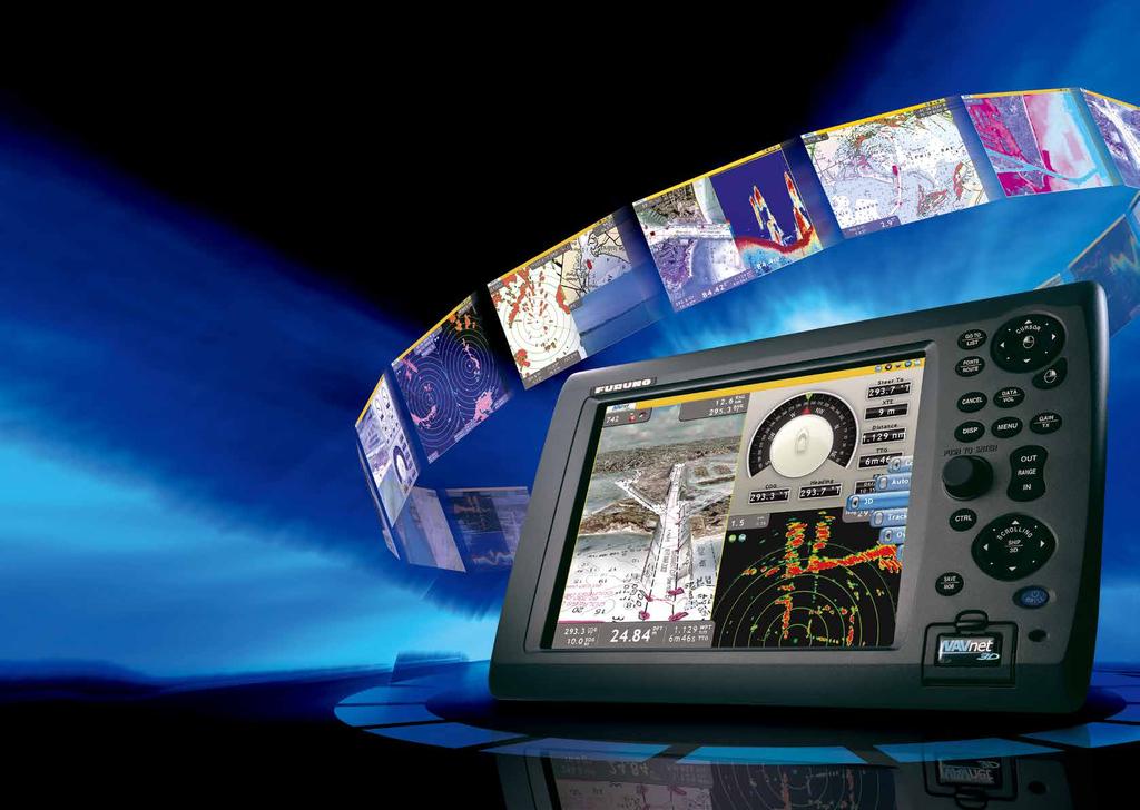
2 Adding a New Dimension to 3D The world of onboard navigation systems has evolved. The desire for faster redraw rates and a more instinctively clear user-interface have been heard and answered. FURUNO s dedication to deliver the best marine electronics has led to the most innovative, powerful solution for onboard navigation ever. Prepare yourself for a revolution. Introducing NavNet 3D. POWERED BY 01-02
3
4 FURUNO s NavNet 3D redefines the user interface of onboard navigation systems. FURUNO s new NavNet 3D is a groundbreaking navigation system that introduces new concepts for a user interface that makes navigating your vessel easier than ever before. Once you start using NavNet 3D, you will be amazed at how a system so powerful can be so simple to use. NavNet 3D comes fully loaded with a variety of groundbreaking, new features that will expand your navigational horizons

, which features a super-charged graphics processor.")
5 The only acceptable wait time is zero, TimeZero TM. NavNet 3D uses a new cutting-edge technology called TimeZero TM. It facilitates seamless chart redraw, allowing zooming, chart panning, changing chart display modes and other chart handling functions without limited range presets. TimeZero TM brings you a truly seamless navigation environment you have to see to believe. For the ultimate in flexibility and the fastest NavNet 3D redraw, look to the Black Box series (MFDBB), which features a super-charged graphics processor. Designed by MAXSEA True 3D environment for a more instinctive chart presentation. NavNet 3D incorporates a whole new dimension into chart presentation with full time 3D chart rendering. You can choose a 2D top-down view of the navigation chart for a look and feel that duplicates a traditional chart plotting presentation. Or, you can choose to pan and zoom the chart to any angle at any range scale you choose instantly. There is no 3D mode to change into and no waiting, because NavNet 3D operates in the true 3D environment full time. Plus it is pre-loaded with full-scale, complete NOAA raster and vector chart libraries for the entire U.S. coastline, including Alaska and Hawaii! To top it off, you can combine them with new Satellite PhotoFusion TM charts. This variety of chart presentations helps to improve your situational awareness by giving you unprecedented control over your charting environment. NavNet 3D RotoKey TM puts a whole new spin on User Friendly NavNet 3D challenges a conventional menu operating system with a whole new concept, the RotoKey TM on-screen revolving menu key. By turning a rotary knob on the control panel, RotoKey TM will be activated, giving you full access to NavNet 3D controls.


6 NavNet 3D Cartography NavNet 3D s powerful graphic engine has added new chart presentation options to the conventional 2D method of chart plotting. With 3D charts and our new Satellite PhotoFusion TM, you can now blend satellite imagery with critical chart data like never before. These new presentation options allow you to visually identify the exact position of your vessel, together with information about the surrounding area on instinctively clear chart orientations that you control. Navigate in True 3D with NOAA Raster, Vector or optional "C-Map by Jeppesen"*and "Datacore by Navionics" Vector and Bathymetric Charts NavNet 3D incorporates native 3D chart architecture that allows for a full-time 3-dimensional presentation, as opposed to 2D charts that require special effects to appear 3D. There are no special modes; that limit your ability to navigate the way you want. With NavNet 3D s true 3D environment, you can see all of the information you want with no limitations on what information you wish to view. Plus, it is pre-loaded with full-scale, complete raster and vector chart libraries for the entire U.S. coastline, including Alaska and Hawaii. Overlay a variety of data with a touch of the Rotokey, such as Radar overlay, Sirius Satellite Weather, AIS targets, ARPA targets plus all of your chart symbols and depth soundings. This is the beauty of navigating in NavNet 3D, you have full control over the presentation at all times. NOAA 3D Raster C-Map by Jeppesen 3D Vector* Satellite PhotoFusion TM * For detailed information, please refer to page Our high-resolution satellite photography can now be fused with raster or vector chart information. Land areas (zero depth) are completely opaque, so that these areas are displayed as high-resolution satellite photos on the chart. As the depth increases, the satellite photography becomes more transparent so that you will know where the shallows end and the deeper water begins, allowing you to navigate on the raster or vector chart. High-resolution satellite photography aids in seabed classification so that you will be able to easily identify areas of sand, rock, coral or other obstructions. Satellite & Raster/PhotoFusion TM 05-06


7 3D Key Even though your raster or vector charts are operating in their native 3D environment full-time, one long press of the 3D key will toggle the chart from a familiar 2D top-down perspective, to your favorite 3D angle. 3D 2D Satellite & 3D chart orientation


8 The Only Acceptable Wait Time is Zero: TimeZero TM Technology Changes Your Perspective on Chart Redraw NavNet 3D s new TimeZero TM technology delivers chart processing like you ve never seen before seamless chart handling, zooming and panning without the screen disappearing. TimeZero TM technology redefines the meaning of stress-free operation by smoothing out your chart handling actions. For the ultimate in chart redraw, step up to the NavNet 3D Black Box. Chart scaling without limitation Zoom seamlessly and continuously to whatever chart scale you desire. Instead of limiting you to a small handful of chart scales to choose from like traditional chart plotters, TimeZero TM architecture allows you to seamlessly zoom in or out to the exact magnification level you like without steps or limitations. Smooth scaling delivers any range scale you desire. Conventional Chart Plotter Wait & Jump Wait & Jump Wait & Jump Conventional chart plotters have fixed range scales that you select from


9 Designed by MAXSEA Easy chart panning gives you freedom to explore You can pan the chart by simply pressing the scrolling pad. This gives you freedom to explore the chart data, allowing you to focus on a specific area ahead of or around your vessel without losing track of your position on the chart. Explore the chart data at your leisure, and then instantly return to own ship at the touch of a single dedicated ship button. Displaying True and Relative Motion is now more intuitive than ever before. TimeZero TM technology provides a useful utility for focusing on a specific direction such as the area ahead of your vessel.


10 Scalable Operating System NavNet 3D is designed with a user-friendly, scalable operating environment, accommodating new boaters as well as experienced navigators. It lets you customize your control of the system. 1 Point & Shoot Interface 1 NavNet 3D allows for a more straightforward user interface with a combination of both RotoKey TM and a familiar point-and-shoot cursor pad control. The power of the point-and-shoot interface allows for incredibly simple operation - click anywhere on the screen for context-sensitive options for that area. Click on any data box to access detailed information for that function. A variety of features can be accessed through a familiar left or right click interface. You can also connect a generic USB mouse to further simplify operation Disp Key One press of the Disp key allows you to easily select the presentation you desire. Five intelligently designed hot-pages are available to you right out of the box, with the ability to save up to ten custom hot-pages. Customize any hot-page with a simple long press of the RotoKey TM, which launches the hot-page wizard


11 3 RotoKey TM This is NavNet 3D s revolutionary new control that merges the power and versatility of soft keys with an easy-to-use rotary knob! One turn of the RotoKey TM gives you instant access to full control of NavNet 3D. The RotoKey TM is designed as a part of NavNet 3D s scalable operating system; a short press of the RotoKey TM gives you access to a user-selected set of the functions that you select upon installation from Basic, Standard, Full or Custom, while a longer press of the key displays all of the functions available. Never leave your navigation screen to enter a menu again! 4 Range Key 5 Scrolling Pad 6 3D Key A simple press of the Range key allows you to adjust the chart/radar range scale of your choice with ultra smooth zooming-in/out actions thanks to TimeZero TM technology. The scrolling pad allows independent scrolling and panning capabilities from a dedicated omni-pad. Pan the chart or shift the radar quickly and seamlessly. You can also control Axis IP cameras without accessing complicated menus or changing your current presentation. One long press of the 3D key will toggle the chart from 3D to a familiar 2D, top-down perspective. While the chart remains in its native 3D environment, only the perspective shifts. Press the key again and you toggle back to 3D. There is no special mode required to shift back to 3D perspective. 3D 2D
12 FURUNO s NavNet 3D Digital Solution sets a new Stan NavNet 3D operates on a fully digitized environment with its highly sensitive digital sensors for radar and fish finder. The operating structure is also digitized, delivering total fusion of hardware and software modules in its operation scheme, utilizing Ethernet, NMEA0183 and CAN bus interface


 fish finders feature advanced filtering capabilities and digital auto tuning, which eliminates noise, while delivering the ability to spot")
13 dard New Ultra High Definition (UHD TM ) Digital Radar NavNet 3D integrates Ultra High Definition (UHD TM ) Digital Radar that facilitates fully automatic, high-precision Gain and Sea Clutter and Tuning Control for hands-free operation and ultimate performance. One of the amazing features of FURUNO UHD TM Digital Radar is a fully independent Real-Time dual range radar display, which scans and displays two different radar ranges simultaneously with no lag at all. UHD TM Digital Radar is fully integrated into NavNet 3D s revolutionary TimeZero technology, facilitating real seamless radar zoom without any display blackout*. Also, the high-resolution radar image can perfectly be overlaid with NavNet 3D s native 3D chart in both 2D and 3D formats. All of these greatly enhance your situational awareness. *NavNet 3D BlackBox (MFDBB) only FURUNO Digital Filter (FDF TM ) Fish Finder You probably know about digital fish finders, but are not quite sure what the term really means. FURUNO Digital Filter (FDF TM ) fish finders feature advanced filtering capabilities and digital auto tuning, which eliminates noise, while delivering the ability to spot individual fish with clarity, accuracy and detail. Whether it is used for shallow or deep water, FURUNO FDF TM fish finder gives you what you would expect from a fish finder at all times. Enhanced shallow water detection by supressing surface clutter. Conventional fish finder DFF1

 is automatically shifted to the appropriate pulse length.")
14 NavNet 3D Digital Sensors The reliability of NavNet 3D lies in its exceptional sensor performance, which is the result of advanced Digital Signal Processing. NavNet 3D digital Radar and Fish Finder sensors greatly improve target detection and presentation capabilities. Ultra High Definition (UHD TM ) Digital Radar FURUNO has taken its NMEA award-winning radar technology to the next level with Ultra High Definition Digital Radar. UHD TM offers crystal clear, target presentation with automatic real-time digital signal processing. Antenna rotation speed (24/36/48 rpm) is automatically shifted to the appropriate pulse length. Commercial-grade radar performance is now available in the ultimate MFD navigation suite. NavNet 3D Real-Time Digital Auto Gain/Sea Clutter Controls NavNet 3D employs revolutionary real-time digital auto Gain/Sea controls to deliver crystal clear radar presentation. With this new technology, NavNet 3D computes and applies an adaptive omni-directional anti-clutter filter with variable intensity depending on bearing. Auto Gain/Sea Controls On Auto Gain/Sea Controls Off Auto Gain/Sea Controls On Auto Gain/Sea Controls Off Real-time Dual Range Radar NavNet 3D s simultaneous scanning technology drives our powerful dual-range radar, providing unsurpassed target detection. With each sweep of antenna, dual progressive scan transmissions are sent, received and processed to display two separate radar ranges on your NavNet 3D display simultaneously. Each radar presentation acts autonomously, allowing for manipulation of individual gain and clutter controls

 and output power as well as suppress surface clutter. It also makes the picture clearer and easier to decipher.")

15 FURUNO Digital Filter (FDF TM ) Fish Finder FURUNO s DFF1 and DFF3 and new BBDS1 (available Late 2010) feature the FURUNO Digital Filter (FDF TM ) technology. These new digital Network Sounders can turn any NavNet display into a powerful, dual frequency digital fish finder. The main difference between digital and conventional fish finders lies in the filtering capabilities and auto adjustments. Our award winning FDF TM technology helps to optimally adjust gain, STC (Clutter) and output power as well as suppress surface clutter. It also makes the picture clearer and easier to decipher. However, even the best digital filter won t help unless you start with a solid basis, such as FURUNO s renowned fish finder technology. This is why FURUNO has been the best friend of fishermen for generations. Bottom Discrimination Display (with BBDS1 only)* NavNet 3D can show the bottom discrimination at the lower end of the fishfinder display, utilizing input from new Network Fish Finder BBDS1 (available Late 2010). Bottom discrimination will be shown in the following four categories; "Rock", "Gravel", "Sand" and "Mud", either in dedicated graphics or colors. This information is helpful in spotting the rich fishing ground where you can boost your catch of the day. There are two bottom discrimination diaplay modes selectable: Rock Rock Gravel Gravel Sand Sand Standard mode: Only the most prominent bottom category of the spot will be displayed. Mud Probability mode: The proportion of the bottom sediment of the spot is displayed in graph. Mud * Bottom discrimination display mode can be used in the following conditions: Water depth: 5 m and deeper** ** The depth discrimination above is the rough idea of depth limit by which the Bottom Discrimination Display function can be used with a Thru-Hull transducer. Also, please note that the Bottom Discrimination function may not work properly when there is excessive noise or bubbles underneath.
16 NavNet 3D Network: Building Block Solution NavNet 3D is built on an Ethernet network, allowing you to add as few or as many components as you desire along with up to ten displays to create your perfect navigational suite. Further, you can connect NMEA0183 and CAN bus devices to any display or BB processor and share that information across the Ethernet network automatically. User setting data can also be transferred by using SD cards for synchronization of operation settings amongst networked displays. Power on/off synchronization amongst all of the NavNet 3D display units can be RADAR FISH FINDER Ethernet ARPA Radar FAR-2xx7 Series FURUNO ARPA/RADAR Series FAR-2xx7 can be connected to NavNet 3D through the Ethernet data link. Network Fish Finder DFF1/DFF3 CAN bus* Radar Sensors GPS Color LCD Sounder FCV-1150 All the NavNet 3D radar sensors incorporate a CAN bus port to which certain CAN bus/nmea2000 sensors can be directly connected. Power for these networked sensors is supplied directly from the radar itself. This unique feature allows for flexible installation of multiple CAN bus/nmea2000 sensors without the need to run cables all the way to the main processor unit. CAN bus/nmea2000 data is converted and distributed throughout the NavNet 3D Ethernet network. GPS GPS/WAAS Antenna GP-330B GPS GPS Navigator GP-33 NMEA0183 GPS/WAAS Antenna BBWGPS Contact External alarm output & point/ MOB alert input MOB Pendant System Ready Any NN3D system is compatible with every Wireless MOB Pendant System through the MOB Contact Closure Input

17 achieved when the dedicated Ethernet hub HUB101 is used. The NavNet 3D system is built upon the most advanced chart plotter technology. Add to this UHD TM Radar and FDF TM Fish Finder, along with your choice from a wide variety of sensor options and up to ten displays. In addition, FURUNO s NAVpilot autopilot can also be connected to the system. It is easy to see how the basic chart plotter display becomes the genesis of the most sophisticated navigational suite available. AIS FAX PC CAMERA SENSORS AIS Receiver FA-30 Network Weather Facsimile Receiver FAX-30 MAXSEA TimeZero Explorer PC Software IP Camera Network Satellite Weather Receiver BBWX1 Class-B AIS Transponder FA-50 INSTRUMENTS COMPASS FI-70 AUTOPILOT Integrated Heading Sensor PG-700 Depth/Speed/Temp Sensor DST-800 DISPLAY NAVpilot-711C Satellite Compass SC-30 Remote Display RD-33 NAVpilot-700 Satellite Compass SC-50/110 Integrated Heading Sensor PG-500R *What is CAN bus? CAN bus is a communication protocol that shares multiple data and signals through a single backbone cable. You can simply connect any CAN bus devices onto the backbone cable to expand your network onboard. With CAN bus, IDs are assigned to all the devices, and status of each sensor in the network can be detected. All the CAN bus devices can be incorporated into the NMEA2000 network.


18 CHART PLOTTER The Most Amazing Chart Plotter You ve Ever Seen The NavNet 3D chart plotter is the most impressive piece of engineering that has ever set foot onto the marine electronics stage. With the incorporation of FURUNO s new TimeZero TM Technology, we have created a chart plotter with blazing speed. The most amazing part is utilization of native 3D charting architecture, showing the exact position of your craft in a wide variety of chart presentation formats. Incorporating a dedicated high-speed processor and powerful graphic engine, NavNet 3D delivers unprecedented levels of performance and utility by seamlessly integrating diverse, essential navigational data. NavNet 3D futher expanded its chart versatile chart plotter with the addition of "C-Map by Jeppesen" charts* NavNet 3D is the only chart plotter on the market providing users the ability to choose from pre-loaded official NOAA raster and vector charts, or optional "C-Map by Jeppesen"* and "Datacore by Navionics" vector cartography. Fully integrating the cutting-edge data analytic algorithm together with high-resolution image processing technique, Mapmedia delivers digital navigation charts and satellite photography with absolute clarity and details. Mapmedia vector and raster charts are built upon 3D architecture, which is smoothly integrated with NavNet 3D s TimeZero TM technology. Mapmedia Raster Raster charts are digitized scans of NOAA paper charts. For the traditionalist who is used to the touch and feel of a paper chart, Mapmedia raster is the option for you. Unlike conventional raster charts, high-resolution scans have been applied to Mapmedia raster so that the chart quality will not deteriorate even when viewed at the smallest of range scales. Mapmedia Rastar Radar-Chart overlay 17-18


 will be necessary to use the new C-Map by Jeppesen charts, which will be available for download at Furuno")


 are completely opaque, so that these areas are displayed as high-resolution satellite")

19 Mapmedia Vector Vector charts contain a huge volume of information in different layers, each of which can be selectively displayed. As you zoom into the chart, increasing levels of detail can be seen without any sacrifice in image resolution. Mapmedia NOAA Vector NOAA Vector + Satellite PhotoFusion TM NavNet 3D now offers three different sources of vector chart options with the addition of C-Map by Jeppesen*. Optional "C-Map by Jeppesen" vector cartography* delivers a wealth of important chart detail for navigation, including spot soundings and depth contours. *A software update (v2.05) will be necessary to use the new C-Map by Jeppesen charts, which will be available for download at Furuno s web site ( Mapmedia C-Map by Jeppesen 2D Vector C-Map by Jeppesen 3D Vector + Satellite PhotoFusion TM Satellite PhotoFusion TM You can load any two ultra-wide high-resolution satellite photo areas at your convenience. These satellite photos are at the highest resolution available on the market today and they cover the entire U.S. Satellite fusion with raster or vector charts is a feature available only with FURUNO s NavNet 3D. Land areas (zero depth) are completely opaque, so that these areas are displayed as high-resolution satellite photos on the chart. As the depth increases, the satellite photography becomes more transparent so that you will know where the shallows end and the deeper water begins, and also allowing the raster or vector chart to be visible. On top of the bundled cartography and satellite photography, you can save the following marks and points in the NavNet 3D internal memory: up to 10,000 ship s track points; up to 2,000 points and 200 planned routes, within which up to 100 waypoints can be placed.


20 CHART PLOTTER Depth Shading A depth color scale can be applied on both 2D and 3D vector and raster charts. Transparency levels can be adjusted so that the chart data is visible beneath the color shading. This unique feature allows you to view water depths at-a-glance with vibrant colors. No more searching for depth numbers, when you can simply set depths to your specified colors. Whether you want to see the depth for navigation or fishing purposes, this new feature makes it easier than ever. Preloaded Tides and Currents information NavNet 3D also comes preloaded with global tide and current information, which can be overlaid onto the chart display Tide Symbol Tide symbols are located where tidal recording stations are. When you place your cursor over the tide symbol, the symbol is magnified. By selecting a tide symbol, you can view a graph with predictions for minimum/maximum tidal height as well as times for sunset and sunrise. 2 Current Indicator Arrows indicate current direction, while size and color indicates current speed
 and short range (foot, meter or yard) according to the current display range.")

21 NAV Data Display and Engine Monitoring NAV Data Display Selected NAV data can be shown at the edges of the screen in nav data windows. 1 Range Data Automatically changes range scale settings between long range (mile, nautical mile or kilometer) and short range (foot, meter or yard) according to the current display range Cursor Data Shows the latitude and longitude position where the cursor is on the chart. Information to be displayed Position Range Bearing 3 3 Ship s Data These user-specified data boxes allow you to display the information you want to see. Customize the data boxes to show single or multiple pieces of information. Click on the box and it will show you the variety of data you can display. When you select multiple data, it will rotate at a specified time interval. Information to be displayed Position COG SOG Depth SST STW Heading True Wind Speed True Wind Direction True Wind Angle Apparent Wind Speed Apparent Wind Angle ROT Trip Log Odometer Date and Time On-screen Navigational Instrument NavNet 3D delivers various on-screen navigation instrument displays. 1 Compass Rose display In the Compass Rose display, you can view the heading, bearing to the waypoint and COG information at the same time in order to see if your craft is on the right track. 1 2 Engine Monitoring When interfaced with the engine that outputs data in the NMEA 2000 format, NavNet 3D can show an on-screen engine monitoring display. The information to be displayed includes tachometer, boost pressure, engine temperature and oil pressure Wind Speed and Direction Either true or apparent wind speed and direction can be shown, when interfaced with a wind sensor.


 3D 2D ARPA/AIS target tracking Automatic radar plotting utility is one of the standard features of the NavNet 3D radar.")
22 RADAR NavNet 3D Radar NavNet 3D s new Ultra High Definition (UHD TM ) Digital Radar technology sets a new standard in marine radar. With a highly advanced digital sensor and signal processing technologies, UHD TM Digital Radar greatly enhances situational awareness. Real-time Dual Range Radar presentation with Dual Progressive Scan NavNet 3D s simultaneous scanning technology allows dual progressive scan to display and update two radar pictures, both long and short range, at the same time as opposed to alternate update methods of typical conventional dual range radar. Autonomous control over gain and anti-clutter can be performed on each radar presentation. This can be used to have one screen with the gain set to locate birds and buoys, while you use the other radar screen to navigate. Radar-Chart overlay Radar image of spot-on accuracy can be overlaid with chart information. Not only is it done with the conventional 2D chart format, but also it can now be projected onto 3D chart presentation! Radar range scales in the radar-chart overlay entirely depend on the range scales in the chart presentation, allowing you to view the radar image on the chart information in whatever magnification level you desire. (An appropriate heading sensor is required.) 3D 2D ARPA/AIS target tracking Automatic radar plotting utility is one of the standard features of the NavNet 3D radar. Up to 30 targets can be simultaneously acquired and tracked for heading and speed. AIS target tracking is accomplished when interfaced with a FA-30/50/150 AIS unit. Real-Time Digital Auto Gain/Sea Controls NavNet 3D employs revolutionary real-time digital auto Gain/Sea controls to deliver a crystal clear radar presentation. With this new technology, NavNet 3D computes and applies an adaptive omni-directional anti-clutter filter with variable intensity depending on bearing. Auto Gain/Sea Controls On Auto Gain/Sea Controls Off Auto Gain/Sea Controls On Auto Gain/Sea Controls Off 21-22
23 Enhanced detection both in long and short range by Digital Radar Sensor Seamless zoom in/out of radar range scales (MFDBB) Enhanced auto tuning, auto gain and anti-clutter controls 48 rpm antenna rotation speed for HSC and river applications Adaptive antenna rotation speed according to pulse length Accurate radar overlay on both 2D/3D chart presentation with aid from heading sensors True echo trail shows afterglow of moving radar targets True Color Radar shows density of targets (32 color levels for the MFD8 and MFD12, 256 color levels for the MFDBB) Radar Guard Zone and Watchman features alert you to potential danger Dual VRM (Variable Range Marker) and dual EBL (Electric Bearing Line) Off-center display capability allows you to focus on specific direction with a simple press of the cursor pad Automatic IP address assignment for true Plug and Play installation Radar Sensors The NavNet 3D radar processor is incorporated into a radome antenna or gearbox. Simply plug in Ethernet and power cable connectors and you will have digital radar sensor within your NavNet 3D network. The IP address is automatically assigned to the radar sensor for true Plug and Play installation. NavNet 3D Radar Sensor Options DRS2D DRS4D DRS4A DRS6A DRS12A DRS25A Output Power 2.2 kw 4 kw 4 kw 6 kw 12 kw 25 kw Size 19 inch 24 inch 3.5 ft 4 ft 4 ft/6 ft 4 ft/6 ft Antenna Type Radome Radome Open Open Open Open Beam Width Horizontal / /1.4 Vertical /22 22 /22 Max. Range 24 nm 36 nm 48 nm 64 nm 72 nm 96 nm 48 rpm Capability FURUNO CAN bus base network The NavNet 3D radar sensor incorporates a CAN bus port to which FURUNO s CAN bus sensors such as the WS-200 Weather Station and the SC-30 Satellite Compass can be directly connected. Power for these networked CAN bus sensors is supplied from the CAN bus. This unique feature allows for flexible installation of multiple CAN bus sensors without the need to run cables all the way to the main processor unit. CAN bus data is converted and distributed throughout the NavNet 3D Ethernet network. Ethernet CAN bus based Network Weather Station WS-200 Sattelite Compass SC-30

 Fish Finder technology Selectable display modes include High or Low Frequency, Dual Frequency, Zoom, Nav Data, A-Scope, Marker")
 transceiver on the DFF3 allows you to")
24 FISH FINDER NavNet 3D Network Fish Finder The FURUNO DFF1 and DFF3 can turn any NavNet 3D display into a powerful, dual frequency fish finder. They can be connected directly to a NavNet display or an Ethernet hub with a single Ethernet cable. DFF1 has 600 W or 1 kw output power, while DFF3 has 1/2/3 kw output power. Both supports a variety of transducer options. Enhanced detection of fish targets by FURUNO Digital Filter (FDF TM ) Fish Finder technology Selectable display modes include High or Low Frequency, Dual Frequency, Zoom, Nav Data, A-Scope, Marker Zoom, Bottom Zoom or Bottom-Lock Audio and visual alarms alert you whenever preset limits are met for water depth, water temperature and fish echoes Two selectable automatic gain control modes: Cruising and Fishing modes to match your boating purposes IP address is automatically assigned for Plug and Play installation FURUNO Free Synthesizer (FFS) transceiver on the DFF3 allows you to choose any two frequencies from 28 to 200 khz FURUNO free Synthesizer (FFS), a mechanism used for the professional fish finder FCV-1200L, is utilized for the DFF3 transceiver. FFS allows you to operate a fish finder in any of the two operating frequencies from 28 to 200 khz without using a matching box. This mechanism gives you the freedom to choose your operating frequencies for more productive fishing. Output power of the DFF3 can also be selected among 1, 2 and 3 kw to suit a variety of situations
 or go with a BlackBox option with custom monitors of screen resolution up to SXGA (1280 x 1024 pixels).")


25 DISPLAY " NavNet 3D Display Options You can select from 8.4" or 12.1" Multi-Function Displays (MFDs) or go with a BlackBox option with custom monitors of screen resolution up to SXGA (1280 x 1024 pixels). You can freely configure your system from the available options to suit your boating style and navigational requirements. All of the NavNet 3D display options come with high brightness, sunlight-readable LCD enhanced by anti-reflective glass coating that allows operation even under the direct sunlight. 8.4" and 12.1" MFDs Choose from 8.4" or 12.1" NavNet 3D MFDs. Its low profile design fits beautifully right into your helm console. Fog-free structural design has been applied to both the MFD8 and MFD12 so that the presentation will never be disturbed by water condensation, caused by an air gap between the LCD and the front coverplate. MFD12 MFD8 BlackBox Configuration The NavNet 3D BlackBox configuration is available for those who wish to choose their own display. You can select either FURUNO s lineup of 15", 19" Marine LCDs or other third party displays. MU-150HD/MU-190HD Marine LCDs MFDBB Keyboard Processor Combine FURUNO s Marine LCD MU Series with MFDBB Processor and Keyboard to configure the NavNet 3D BlackBox system
 Video Out Resolution: SVGA 8.4\" LCD VGA (640 x 480) Video Out Resolution: VGA 12.")
 2 inputs 4 inputs SD Card Slot 2 slots 2 slots in a control unit Audio IN/OUT 1 output Changing your display presentation is easier than ever before!")


26 DISPLAY Easy Flush Mount Installation Flush mounting your display is now easier than ever. All NavNet 3D display options attach to the mounting console with bolts from the front side. NavNet 3D Display Options Screen Size and Resolution MFD8 MFD12 MFDBB 12.1" LCD SVGA (800 x 600) Video Out Resolution: SVGA 8.4" LCD VGA (640 x 480) Video Out Resolution: VGA 12.1" SVGA (800 x 600) 15" XGA (1024 x 768) 17" SXGA (1280 x 1024) Brightness 700 cd 1100 cd NMEA0183 in/out 3 x in/out ports CAN bus/nmea port Ethernet (100 BASE-TX) 1 port 4 port hub included USB 1 x USB x USB 2.0 Video IN (NTSC/PAL) 2 inputs 4 inputs SD Card Slot 2 slots 2 slots in a control unit Audio IN/OUT 1 output Changing your display presentation is easier than ever before! NavNet 3D allows you to customize your display from a single screen presentation up to a four-way-split arrangement. NavNet 3D comes standard with five display hot-pages to select, with the ability to increase your options to ten hot-pages. Rearrange the display configuration to suit your style by combination of the DISP key and RotoKey TM. You can freely configure the display so that you will have the information you want right where you want it! Single Screen Display In the single screen display mode, you can place the presentation of chart plotter, radar, fish finder and external video camera. Split-Screen Display NavNet 3D allows you to split the screen in up to four separate segments. In each segment, you can assign the following information. 2 1 In the half-way split screen, you can place the chart plotter, radar, fish finder and external video camera. 1 2 In the quarter-split-screen, you can place the presentation of chart plotter, radar, fish finder, external video camera and navigation instruments. Chart plotter Radar External video camera Fish finder Navigation instrument


27 Status Bar and Status Icons The status bar at the top of the display provides you with operating information with text messages and sensor status icons. Default Bar color turn to red Sensor Status Icons The Sensor Status Icons show whether the sensors are active or inactive. The sensor icons are animated when active, and a red X is placed over the icons when the sensor is inactive. Sensor working in order Multimedia Weather Compass GPS Fish Finder Sensor inactive Emergency Radar Text Message Text messages include operational guide and alarm messages. When set alarm criteria are met or violated, the status bar turns red and the warning status message is shown in the status bar. IP Camera & External Video Camera Displays NavNet 3D displays video input from onboard IP cameras and analog video cameras, allowing you to monitor the engine room and surroundings while navigating from the helm or keeping an eye on blind spots while docking. The MFD8 and MFD12 incorporates two video input ports, while the MFDBB has four video input ports, supporting multiple video sources to be displayed at the same time for enhanced navigation monitoring. Up to four IP cameras can be connected to the network. Pan, tilt and zoom features can be controlled from the NavNet 3D scrolling pad when utilizing Axis IP cameras with these capabilities. PIP/ MONITORING IP Camera AV Camera Onboard Monitoring Engine Room Monitoring


28 SYSTEM EXPANDABILITY Enhanced Monitoring of Surrounding Areas Once interfaced with the Satellite Compass and AIS receiver/transponder, NavNet 3D enables enhanced monitoring of vessel traffic around your craft for a safer boating experience. Enhanced Radar/Chart Overlay, ARPA Target Tracking and Echo Trail When interfaced with the highly accurate heading data from the SC-30/50/110 Satellite Compass, NavNet 3D Radar/Chart overlay, ARPA Target Tracking and Echo Trail functions can be greatly enhanced. Even when performing quick turning maneuvers or running into rough seas, NavNet 3D with the SC-30/50/110 presents clear and stable radar echo trails, constant ARPA tracking and spot-on Radar/Chart Plotter Overlay. Radar-Chart overlay Radar echo trail 27-28

 improves the safety level of boating by exchanging information about the status of own ship with other nearby AIS-equipped craft.")
29 AIS Target Tracking When the FURUNO AIS FA-30/50/150 is interfaced with NavNet 3D, the AIS information is integrated into the NavNet 3D network to facilitate enhanced monitoring of the surrounding area from any station. Up to 100 AIS targets can be tracked and displayed with five different symbols to indicate their status. Detailed information about a specific target can be viewed in a pop-up AIS data window. What is AIS? The Automatic Identification System (AIS) improves the safety level of boating by exchanging information about the status of own ship with other nearby AIS-equipped craft. The system utilizes VHF broadcasts to share information about the surrounding area, such as other craft and buoys and other aids to navigation. AIS data includes position, course and speed over ground, allowing you to foresee the course changes of specific targets. AIS targets are constantly visible even when they are shrouded in fog or darkness, or hidden behind capes, river bends and other obstructions. AIS DATA Information to be Exchanged Dynamic Data Ship s Position Coordinated Universal Time (UTC) Course over Ground (COG) Speed over Ground (SOG) Rate of Turn (ROT) Heading Navigation Status Static Data MMSI (Maritime Mobile Service Identity) IMO Number Ship s Name Type of Ship Call Sign Length and Beam Location of Position-Fixing Antenna on the Ship Voyage-Related Data Ship s Draft Hazardous Cargo Destination and Estimated Time of Arrival (ETA) Safety-Related Messages Heaving Compensation with Satellite Compass SC-30/50/110 An unstable fish finder presentation caused by vessel s heaving motion will no longer be an issue. FURUNO s Satellite Compass SC-30, SC-50 and SC-110 detect your vessel s heaving motion and transfer the data to the networked fish finder. It then corrects the echo distortion and delivers stable underwater presentation to your network. Heaving compensation ON Heaving compensation ON 11m 10m 9m 5m Heaving compensation OFF Heaving compensation OFF 0m


 is required.")

30 SYSTEM EXPANDABILITY Weather Data Integration Sirius Satellite Marine Weather Keeping track of weather is easier than ever with FURUNO s Sirius Satellite Weather Receiver BBWX1 for NavNet 3D. FURUNO and Sirius have teamed up to bring you live, up-to-the-minute weather information and forecasting to give you peace of mind, no matter when or how you are boating. The weather information is obtained from the weather industry s leading experts and is delivered via digital receiver through Sirius Marine Weather services. You have the ability to receive high-quality and comprehensive weather information and forecasting that you can overlay with your NavNet 3D charts. You will be provided with premium weather contents, such as current weather reports, NOWRad nationwide high resolution weather radar imagery and Sea Surface Temperature images that can help fishermen locate hot spots. Available only in the U.S., Sirius Marine Weather service coverage includes the 48 contiguous states, most of Canada, Mexico, and waters extending hundreds of miles into the Atlantic and Pacific oceans, the Gulf of Mexico, and Caribbean. A monthly Sirius Marine Weather subscription (sold separately) is required. An added benefit is the ability to now control Sirius Radio audio on NavNet 3D when connected to an external speaker. Sea Surface Temperature Visual reading on varying surface water temperature can be acquired: with red showing the warmest and blue showing the coolest areas. FAX-30 Turn your NavNet 3D display into Weather fax/navtex receiver by connecting the FAX-30 Weather Receiver. Up to 12 satellite photos can be stored in memory Programmed with all currently available facsimile stations: up to 320 channels available Presentation in monotone, 16-gradation gray scale or color (three patterns of color presentation are available) Built-in NAVTEX receiver (490 khz and 518 khz) can store up to 130 messages 29-30


 on the web site.")


31 Whenever you require any information about NavNet 3D, just visit our web site, solely dedicated to the current and wouldbe users of NavNet 3D, At NavNet.com, you can access the contents with in-depth product information from various angles, including a NavNet 3D demonstration film, introduction to the product, product specifications, online tutorial, training video, system suggestions and user interviews and much more! Also, you can find answers to questions you may have in our solution database (FAQs) on the web site. Your benefits from "My NavNet" through NavNet 3D online user-registration For your convenience, you can register your NavNet 3D products online at NavNet.com. When you register online, you will automatically gain access to your My NavNet page where you will gain access to various premium benefits, including: online software updates, online chart update and personalized news services. The site is updated constantly to deliver the most up-to-date information about the product.

32 Multi Function Display MFD8 MFD12 MFDBB Network Fish Finder DFF1 DFF3 GPS/WAAS Receiver Antenna BBWGPS GP-330B Network Weather Facsimile Receiver FAX-30 Network Satellite Weather Receiver BBWX1 LCD Display MU-150HD MU-190HD SPECIFICATIONS NavNet 3D Radar Sensor DRS2D DRS4D DRS4A DRS6A DRS12A DRS25A 31-32
 1100 cd (typical) Display Colors Chart Plotter/Menu: 65,536 colors Fish Finder: 64 colors Radar:")
 Display Modes Course plot, NAV data, Navigational instrument display, Engine monitoring display Latitude Limit Between")
33 Multi Function Display MFD8 MFD12 DISPLAY UNIT Type 8.4" Color TFT LCD 12.1" Color TFT LCD Screen Size 8.4", x mm 12.1", x mm Screen Resolution VGA 640 x 480 pixels SVGA 800 x 600 pixels Screen Brightness 700 cd (typical) 1100 cd (typical) Display Colors Chart Plotter/Menu: 65,536 colors Fish Finder: 64 colors Radar: 32 Colors Language English (US & UK), French, Spanish, German, Italian, Portuguese, Swedish, Danish, Norwegian, Finnish, Dutch, Japanese PLOTTER CHARACTERISTICS Memory Capacity Up to 10,000 points for ship's tracks, 2000 user points, 200 planned routes (100 points per route) Display Modes Course plot, NAV data, Navigational instrument display, Engine monitoring display Latitude Limit Between 85 N and 85 S Alarms Anchor Watch, XTE, Proximity, Depth, Temperature, Speed, Trip Log, Countdown, Timer, Alarm Clock RADAR CHARCTERISTICS Display Modes Head-up, Course-up*, North-up*, Relative Motion, True Motion** (*Heading input required **Heading and speed inputs required) Echo Trail Interval: 15 s, 30 s, 1 min, 3 mins, 6 mins, 15 mins, 30 mins and continuous INTERFACE LAN 1 Port, 100 BASE-TX NMEA Ports for Input/Output Interface (NMEA0183) Input: DBK, DBS, DBT, DPT, DTM, GGA, GLL, GNS, HDG, HDM, HDT, MDA, MTW, MWV, RMA, RMC, ROT, VDM, VHW, VTG, VWR, VWT, ZDA, FURUNO Proprietary Sentences are used for pitch, roll and heave data input from FURUNO Satellite Compass SC series. Output: AAM, APB, BOD, BWC, BWR, DBT, DPT, DTM, GGA, GLL, GNS, GTD, HDG, HDT, MTW, MWV, RMA, RMB, RMC, ROT, VHW, VTG, WPL, XTE, ZDA, ZTG, FURUNO Proprietary Sentence is used for true heading, pitch and roll data output. CAN bus/nmea Port , , , , , , , , , , , , , , Input: Interface , , , , , , , , , , , , (CAN bus/nmea2000 *) , , , , , , , , , , , , , , Output: , , , , , , , , , USB Port 1 Port (USB 1.1) Video Output 1 Port (DVI-D VGA) 1 Port (DVI-D SVGA) Video Input 2 Ports (NTSC/PAL) Line Out 1 Port SD Card Slot 2 Slots Variable Line Level Stereo Output N/A ENVIRONMENT Display Unit Temperature (IEC60945) Processor Unit -15 C to +55 C Control Unit N/A Display Unit IP56 (IEC60529) Waterproofing Processor Unit N/A Control Unit N/A POWER SUPPLY VDC 29 W/73 W (with DRS2D)/77 W (DRS4D)/104 W (with DRS4A)/ 131 W (with DRS6A)/143 W (with DRS12A)/174 W (with DRS25A) 41 W/86 W (with DRS2D)/91 W (DRS4D)/132 W (with DRS4A)/ 144 W (with DRS6A)/159 W (with DRS12A)/186 W (with DRS25A) 100/110/220/230 VAC with optional rectifier RU-1746B-2/PR-62/RU-3423 * With regard to the NMEA 2000 PGN specifications, please refer to P.37. Multi Function Display (Table-top Mount) MFD8 4.7 kg 10.4 lb Multi Function Display (Flush Mount) MFD8 3.9 kg 8.6 lb " " " " " " 4-ø " " " " " " " " " " " " " 4-ø " " " " " " " Cut-out for flush mount Multi Function Display (Table-top Mount) MFD kg 15.0 lb " " " " " " 45 Multi Function Display (Flush Mount) MFD kg 11.9 lb " " " " " " " " " " " " " " " 4-ø " " " 4-ø " " Cut-out for Flush Mount "
34 SPECIFICATIONS Multi Function Display MFDBB DISPLAY UNIT Type Custom monitor of your choice Screen Size Please refer to the specifications of MU-120C/155C/170C Screen Resolution SVGA 800 x 600 pixels, XGA 1024 x 768 pixels or SXGA 1280 x 1024 pixels Screen Brightness Please refer to the specifications of MU-120C/155C/170C Display Colors Chart Plotter/Menu: 262,144 colors Fish Finder: 64 colors Radar: 256 colors Language English (US & UK), French, Spanish, German, Italian, Portuguese, Swedish, Danish, Norwegian, Finnish, Dutch, Japanese PLOTTER CHARACTERISTICS Memory Capacity Up to 10,000 points for ship's tracks, 2000 user points, 200 planned routes (100 points per route) Display Modes Course plot, NAV data, Navigational instrument display, Engine monitoring display Latitude Limit Between 85 N and 85 S Alarms Anchor Watch, XTE, Proximity, Depth, Temperature, Speed, Trip Log, Countdown, Timer, Alarm Clock RADAR CHARCTERISTICS Display Modes Head-up, Course-up*, North-up*, Relative Motion, True Motion** (*Heading input required **Heading and speed inputs required) Echo Trail Interval: 15 s, 30 s, 1 min, 3 mins, 6 mins, 15 mins, 30 mins and continuous INTERFACE LAN 4-Port Hub is included, 100 BASE-TX NMEA Ports for Input/Output Interface (NMEA0183) Input: DBK, DBS, DBT, DPT, DTM, GGA, GLL, GNS, HDG, HDM, HDT, MDA, MTW, MWV, RMA, RMC, ROT, VDM, VHW, VTG, VWR, VWT, ZDA, FURUNO Proprietary Sentences are used for pitch, roll and heave data input from FURUNO Satellite Compass SC series. Output: AAM, APB, BOD, BWC, BWR, DBT, DPT, DTM, GGA, GLL, GNS, GTD, HDG, HDT, MTW, MWV, RMA, RMB, RMC, ROT, VHW, VTG, WPL, XTE, ZDA, ZTG, FURUNO Proprietary Sentence is used for true heading, pitch and roll data output. CAN bus/nmea Port , , , , , , , , , , , , , , Input: Interface , , , , , , , , , , , , (CAN bus/nmea2000 *) , , , , , , , , , , , , , , Output: , , , , , , , , , USB Port 2 Ports (USB 2.0) Video Output 2 Ports (DVI-D) Video Input 4 Ports (NTSC/PAL) Line Out 1 Port SD Card Slot 2 Slots Variable Line Level Stereo Output 1 Port ENVIRONMENT Display Unit -15 C to +55 C (DCU12) Temperature (IEC60945) Processor Unit 0 C to +45 C Control Unit -15 C to +55 C Display Unit IP56 (DCU12 when flush mounted) IEC60529 Waterproofing Processor Unit IP20 Control Unit IP56 (MCU-001 when flush mounted) IEC60529 POWER SUPPLY * With regard to the NMEA 2000 PGN specifications, please refer to P VDC 104 W/149 W (with DRS2D)/154 W (DRS4D)/195 W (with DRS4A)/ 207 W (with DRS6A)/222 W (with DRS12A)/249 W (with DRS25A) 100/110/220/230 VAC with optional rectifier RU-1746B-2 Multi Function Display MFDBB BlackBox Processor Unit MPU kg 33.1 lb " " " " " " " " 2ø " " BlackBox Control Unit MCU kg 2.2 lb " " " " 4-ø " " " 4ø " " " " " 1.9" 5.9" " " " 33-34
, Dual (Both High and Low frequencies), Bottom-lock, Bottom-Zoom, Bottom Discrimination, Marker Zoom, A-Scope Frequency Dual frequency 50 khz and 200 khz")
 Up to 2,400 m (8,000 ft, 1,300 fa) ENVIRONMENT Temperature -15 C to +55 C Water Proofing IEC 60529 IP20 POWER SUPPLY TRANSDUCERS (Specify when ordering) 12-24 VDC 12 W 30 W 600 W")
 1kW (Optional Matching box, MB-1100 may be required) 50 khz: 50B-6, 50B-6B, 50B-9B 200 khz: 200B-5S, 50/200 khz: 50/200-1T, 50/200-12M 28 khz 28F-8, 28F-18, 28BL-6HR, 28F-24H,")
35 ST-BY DFF3 NETWORK SOUNDER 89 Network Fish Finder DFF1 DFF3 TRANSCEIVER & DISPLAY Display Modes Single (50 or 200 khz), Dual (50 and 200 khz), Bottom-lock, Bottom-Zoom, Bottom Discrimination, Marker Zoom, A-Scope Single (High or Low frequency), Dual (Both High and Low frequencies), Bottom-lock, Bottom-Zoom, Bottom Discrimination, Marker Zoom, A-Scope Frequency Dual frequency 50 khz and 200 khz The synthesized transducer works with dual frequencies between 28 and 200 khz Outpot Power 600 W/1 kw 1, 2 or 3 kw Range Scale Any range customized between 2 and 1,200 m Range Phasing Up to 2,400 m (8,000 ft, 1,300 fa) Up to 2,400 m (8,000 ft, 1,300 fa) ENVIRONMENT Temperature -15 C to +55 C Water Proofing IEC IP20 POWER SUPPLY TRANSDUCERS (Specify when ordering) VDC 12 W 30 W 600 W 50/200 khz: 520-5PSD (Plastic, thru-hull), 520-5MSD (Bronze, thru-hull), 520-5PWD (Plastic, transom), 525ST-MSD (Bronze, thru-hull with speed/temp sensor), 525ST-PWD (Plastic, transom, with speed/temp sensor) 1kW (Optional Matching box, MB-1100 may be required) 50 khz: 50B-6, 50B-6B, 50B-9B 200 khz: 200B-5S, 50/200 khz: 50/200-1T, 50/200-12M 28 khz 28F-8, 28F-18, 28BL-6HR, 28F-24H, 28BL-12HR 38 khz 38BL-9HR, 38BL-15HR 50 khz 50B-6/6B, 50B-9B, 50B-12, 50BL-12HR, 50F-24H, 50BL-24HR 68 khz 68F-8H, 68F-30H 82 khz 82B-35R 88 khz 88B-8, 88B-10, 88F-126H 107 khz 100B-10R 150 khz 150B-12H 200 khz 200B-5S, 200B-8/8B, 200B-12H 50/200 khz 50/200-1ST, 50/200-1T, 50/200-12M GPS/WAAS Receiver Antenna BBWGPS GP-330B RECEIVER CHARACTERISTICS Receiver Type Twelve discrete channels, C/A code, all-in-view, WAAS Receiving Frequency L1 ( MHz) Time to First Fix 12 s (warm start) 90 s (cold start) Tracking Velocity 999 kt Geodetic Systems WGS-84, NAD-27 and others Accuracy 10 m (GPS) 3 m (WAAS) ENVIRONMENT (IEC test method) Temperature -25 C to +70 C -25 C to +55 C Waterproofing IEC IPX6 IEC IP56 POWER SUPPLY VDC 12 VDC 1.3 W 1.8 W Network Fish Finder DFF1 1.3 kg 2.9 lb 2-ø " " " 4-ø " " " " " " " Network Weather Facsimile Receiver FAX-30 TRANSCEIVER CHARACTERISTICS Frequency Range 80 khz to 160 khz, 2 MHz to 25 MHz, 490 khz, 518 khz (NAVTEX) Class of Emmision F3C, J3C, F1B (NAVTEX) Receiving System Double superheterodyne Storage Fax: 12 pictures NAVTEX: 130 messages ENVIRONMENT (IEC test method) Temperature -15 C to +55 C Waterproofing IEC IPX2 POWER SUPPLY Network Fish Finder DFF3 3.8 kg 8.4 lb 2-ø VDC 12 W " " 2-R3 2-ø " " " " " ø " " " " " " " (for the US market only) Network Satellite Weather Receiver BBWX1 TRANSCEIVER CHARACTERISTICS Receiver Type Sirius Satellite Radio Weather Receiver Mounting Bulkhead Interface Ethernet ENVIRONMENT Temperature 0 C to +55 C (Operating) -35 C to +85 C (Storage) Waterproofing IEC IPX5 POWER SUPPLY VDC 10 W GPS/WAAS Receiver Antenna BBWGPS 0.8 kg 1.8 lb 10 m cable attached 3.5" " GPS/WAAS Receiver Antenna GP-330B 0.22 kg 0.49 lb Network Weather Facsimile Receiver FAX kg 4.4 lb Network Satellite Weather Receiver BBWX1 1.9 kg 4.2 lb (for the US market only) 8 0.3" " " "
36 SPECIFICATIONS LCD Display MU-150HD MU-190HD DISPLAY UNIT Screen Size 15 inches, x mm 17 inches, x mm Resolution XGA 1024 x 768 pixels SXGA 1280 x 1024 pixels Contrast Ratio 600: 1 900: 1 Viewing Angle Vertical up 80 to down 80 or more Horizontal left 80 to right 80 or more Brightness Max cd/m 2, Min. 0.2 cd/m 2 or under INTERFACE Analog RGB 1 port, D-SUB/15 pins DVI 2 ports, DVI-D Composite (RCA) input 3 ports, NTSC/PAL ENVIRONMENT (IEC test method) Temperature -15 C to +55 C Waterproofing IP56 (CFR46 Front Panel), IP22 (Back Panel) POWER SUPPLY VDC, A VDC, A MU-150HD Table-top Mount (option) 7.4 kg 16.3 lb MU-150HD Flush Mount 5.4 kg 11.9 lb Ø MU-190HD Table-top Mount (option) 11 kg 24.3 lb MU-190HD Flush Mount 8.2 kg 18.1 lb Ø
 0.15 μs/3000 Hz (1 to 1.5 nm) 0.3 μs/1500 Hz (2 nm) 0.5 μs/1000 Hz (3 to 4 nm) 0.7 μs/600 Hz (6 to 8 nm) 0.8 μs/600 Hz (12 to 24 nm) 0.08 μs/3000 Hz (0.0625 to 0.75 nm) 0.15 μs/3000 Hz (1 to 1.5 nm) 0.3 μs/1500 Hz (2 nm) 0.5 μs/1000 Hz (3 to 4 nm) 0.7 μs/600 Hz (6 to 8 nm) 0.8 μs/600 Hz (12 to 36 nm) 0.")

37 NavNet 3D Radar Sensor DRS2D DRS4D DRS4A ANTENNA Peak Output Power 2.2 kw 4 kw 4 kw Type 19" Radome 24" Radome 3.5' Open RF TRANSCEIVER Frequency 9410 ± 30 MHz Pulselength & PRR 0.08 μs/3000 Hz ( to 0.75 nm) 0.15 μs/3000 Hz (1 to 1.5 nm) 0.3 μs/1500 Hz (2 nm) 0.5 μs/1000 Hz (3 to 4 nm) 0.7 μs/600 Hz (6 to 8 nm) 0.8 μs/600 Hz (12 to 24 nm) 0.08 μs/3000 Hz ( to 0.75 nm) 0.15 μs/3000 Hz (1 to 1.5 nm) 0.3 μs/1500 Hz (2 nm) 0.5 μs/1000 Hz (3 to 4 nm) 0.7 μs/600 Hz (6 to 8 nm) 0.8 μs/600 Hz (12 to 36 nm) 0.08 μs/3000 Hz ( to 0.75 nm) 0.15 μs/3000 Hz (1 to 1.5 nm) 0.3 μs/1500 Hz (2 nm) 0.5 μs/1000 Hz (3 to 4 nm) 0.7 μs/600 Hz (6 to 8 nm) 0.8 μs/600 Hz (12 to 48 nm) Beam Width Horizontal Vertical Range Scales to 24 nm to 36 nm to 48 nm Antenna Rotation Speed 24/36/48 rpm Wind Load Relative Wind 70 kt ENVIRONMENT Temperature -30 C to + 55 C Waterproofing IP26 MFD8 Not required (Power Provided by the Display Unit) PSU-012 (75 W) Power Amp Unit MFD12 Not required (Power Provided by the Display Unit) MFDBB Not Required (Power Provided by the BB Processor) 19" Radome Radar Sensor DRS2D 6.5 kg 14.3 lb " 3.5' Open Radar Sensor DRS4A 25 kg 55.1 lb " " " " " Ship head (80) (3.1") " ø " " 4-M " " " " " " " " " " " 4-ø " 4-ø " " " " " 24" Radome Radar Sensor DRS4D 7.5 kg 16.5 lb " " " " " " " (125) (4.9") " " 4-M10 ø " " "
SPECIFICATIONS SUBJECT TO CHANGE WITHOUT NOTICE PLEASE READ MANUAL BEFORE USING THE UNIT 12035SK Printed in Japan Catalogue No.
 www.furuno.com All brand and product names are registered trademarks, trademarks or service marks of their respective holders. SPECIFICATIONS SUBJECT TO CHANGE WITHOUT NOTICE PLEASE READ MANUAL BEFORE
TRADEMARK REGISTERED SPECIFICATIONS SUBJECT TO CHANGE WITHOUT NOTICE 1201XSK Printed in Japan Catalogue No. R-201
 T o t a l C o n t r o l a t y o u r F i n g e r t i p s www.furuno.com All brand and product names are registered trademarks, trademarks or service marks of their respective holders. Alpha blending technology
The FA-50 offers accurate information for collision avoidance
 The FA-50 offers accurate information for collision avoidance with GPS antenna GPA-017S FURUNO s FA-50 class-b AIS transponder receives navigation data from AIS-equipped vessels nearby that can be utilized
Catalog No. GC SK
 www.furuno.com All other brand and product names are trademarks, registered trademarks or service marks of their respective holders. SPECIFICATIONS SUBJECT TO CHANGE WITHOUT NOTICE Catalog No. GC-028 1302SK
Total Control, Simply Refined
 Total Control, Simply Refined Total Control, Simply Refined With a sleek all glass front, refined graphical user interface, built-in RezBoost Fish Finder, and internal GPS antenna, NavNet TZtouch2 is a
The FA-30 delivers Real-Time AIS information to navigation systems providing critical collision avoidance information
 The FA-30 delivers Real-Time AIS information to navigation systems providing critical collision avoidance information Acquisition and tracking of traffic around your vessel is absolutely necessary for
JMA-3300 Radar. Semi-Constaview digital signal processing inch ultra bright LCD New System-on-Chip technology
 JMA-3300 Radar JRC s new radar incorporates the latest leading technologies 10.4-inch ultra bright LCD New System-on-Chip technology Semi-Constaview digital signal processing AIS and MARPA+ as standard
for collision avoidance
 The FA-50 offers accurate information for collision avoidance with GPS antenna GPA-017S FURUNO s FA-50 class-b AIS transponder receives navigation data from AIS-equipped vessels nearby that can be utilized
Specifications of NavNet vx2
 Specifications of NavNet vx2 18" Radome Antenna 4.9 kg 10.8 lb Ø460 18.1" (160 6.3") Fixing holes 4-M10 24" Radome Antenna 8 kg 17.6 lb Ø602 23.7" Fixing holes (160 6.3") 4-M10 Cable Entry 226 8.9" 310
Models FRS-1000A/1000B/1000C
 Integrated navigation package RADAR / PLOTTER / SOUNDER Models FRS-1000A/1000B/1000C The future today with FURUNO's electronics technology. FURUNO ELECTRIC CO., LTD. 9-52 Ashihara-cho, Nishinomiya City,
Total Control, Simply Refined
 Total Control, Simply Refined Total Control, Simply Refined With a sleek all glass front, refined graphical user interface, built-in RezBoost Fish Finder, and internal GPS antenna, NavNet TZtouch2 is a
NC Models. CP390i - GPS Chart Plotters. Addendum to Owner s Manual Issue C to update to Software Version (*)
") CP390i - GPS Chart Plotters (*) NC Models to Owner s Manual Issue 16.50 C 300311 to update to Software Version 16.70 BUILT-IN CHARTS ARE NOT INSTALLED The following paragraphs/pictures are not applicable:
CP390i - GPS Chart Plotters (*) NC Models to Owner s Manual Issue 16.50 C 300311 to update to Software Version 16.70 BUILT-IN CHARTS ARE NOT INSTALLED The following paragraphs/pictures are not applicable:
10.4 Multi-Color LCD RADAR 1835/1935/1945. Model. Auto Tuning (Sensitivity)
") 10.4 Multi-Color LCD RADAR 1835/1935/1945 Auto Tuning (Sensitivity) www.furuno.com Bringing a New Level of Quality, Operability, and Reliability into Marine Radar. Furuno's new Radar series, 1835/1935/1945,
10.4 Multi-Color LCD RADAR 1835/1935/1945 Auto Tuning (Sensitivity) www.furuno.com Bringing a New Level of Quality, Operability, and Reliability into Marine Radar. Furuno's new Radar series, 1835/1935/1945,
Date of issue: Version 01. December TRANSAS ISAILOR Functional comparison on ios and Android platforms.
 Date of issue: Version 01. December 2017 TRANSAS ISAILOR Functional comparison on ios and Android platforms. TRANSAS ISAILOR 2 1991 2017 Transas Marine Ltd. All rights reserved. The information contained
AIS6 / MFR6 User Manual
 AIS6 / MFR6 User Manual Important Features at a glance Below you will find a brief summary of the main features of your Seatec AIS6 / MFR6. Your Seatec AIS6 / MFR6 will be your reliable partner for a safe
Broadband 4G Radar. Reinventing Radar
 2012 Broadband 4G Radar Reinventing Radar Reinventing Radar Simrad Yachting has pioneered a new standard of Dome Radars the first with the award-winning BR24, and more recently, with the Broadband 3G Radar.
Specifications of NavNet vx2
 Specifications of NavNet vx2 18" Radome Antenna 4.9 kg 10.8 lb Ø460 18.1" (160 6.3") Fixing holes 4-M10 24" Radome Antenna 8 kg 17.6 lb Ø602 23.7" Fixing holes (160 6.3") 4-M10 Cable Entry 226 8.9" 310
INTERCONNECTION DIAGRAM FA-50
 www.furuno.com The FA-50 offers accurate information exch for collision avoidance with GPS antenna GPA-017S FURUNO s FA-50 class-b AIS transponder receives navigation vector, which greatly assists you
Easy. Touch. Simrad NSS Touch-Screen Multifunction Displays
 Easy. Touch. Simrad NSS Touch-Screen Multifunction Displays A Touch simpler. SIMRAD NSS Introducing NSS. Incorporating outstanding Simrad Touch Sensible technology, the all-new NSS Sport is the touch-screen
Simrad R5000 IMO/Solas Type Approved Radar Systems
 Simrad R5000 IMO/Solas Type Approved Radar Systems R5000 www.navico.com/commercial R5000 Radar Systems SIMRAD R5000 Radar Systems feature a modular plug & play design making it easy to create a cost effective
Reinventing Radar SIMRAD-YACHTING.COM
 2012 Broadband 4G Radar Reinventing Radar SIMRAD-YACHTING.COM Reinventing Radar Simrad Yachting has pioneered a new standard of dome radar, first with the award-winning BR24, and more recently with the
FURUNO DEEPSEA WORLD Class-A Universal AIS Automatic Identification System. The future today with FURUNO's electronics technology.
 R FURUNO DEEPSEA WORLD Class-A Universal AIS Automatic Identification System Model FA-100 The AIS improves the safety of navigation by assisting in the efficient navigation of ships, protection of the
STRIKER Series. Owner s Manual
 STRIKER Series Owner s Manual Table of Contents Introduction...1 Device Keys... 1 Contacting Garmin Product Support... 1 Selecting the Transducer Type... 1 Zooming on the STRIKER 4... 1 Panning on the
INSTALLATION MANUAL NMEA DATA CONVERTER IF-NMEA2K2
 INSTALLATION MANUAL NMEA DATA CONVERTER WARNING Do not install the unit where it may get wet from rain or water splash. Water in the unit can result in fire, electrical shock or damage the equipment. Do
GPSMAP 700 series owner s manual
 GPSMAP 700 series owner s manual Introduction Introduction WARNING See the Important Safety and Product Information guide in the product box for product warnings and other important information. This manual
NEW FOR Radar. Broadband. The evolution of the radar revolution.
 NEW FOR 2011 Broadband Radar The evolution of the radar revolution. The evolution of the radar revolution. The original BR24 Broadband Radar, the frequency modulated continuous wave (FMCW) radar, has captured
G142C and G142CFD INSTRUCTION MANUAL.
 G142C and G142CFD INSTRUCTION MANUAL www.gme.net.au Important It is the owner s sole responsibility to install and use the unit in a manner that will not cause accidents, personal injury or property damage.
Airmar PB200. Furuno. Furuno FI504 FI501 XDR N2K N2K N2K. Furuno. Furuno FI504 FI504 N2K N2K. Terminal RX2 A RX2 B
 Diagram: Navigation Equipment Above Decks Pilothouse kw 6.5' XN0AF Open Array FAR7BB/DC See manual Defender Composite DRS6a 4' Array DRS **Note Monitor cables must be long enough to reach any of the 3
Broadband 3G Radar The evolution of the radar revolution.
 Broadband 3G Radar The evolution of the radar revolution. SIMRAD-YACHTING.COM The evolution of the radar revolution. Broadband Radar a.k.a. frequency modulated continuous wave (FMCW) radar is nothing new...
NSE EXPERT NSE12. Rotary controller: Perfectly intuitive for fine or course control of gain, zoom and menu with push to enter functionality
 NSE EXPERT Simrad NSE 8- and 12-inch multifunctional displays provide professional-level performance with sophisticated charting, radar and echosounder technology. With powerful networking and vessel integration
Broadband. Radar. The evolution of the radar revolution.
 Broadband Radar The evolution of the radar revolution. www.simrad-yachting.com The evolution of the radar revolution. The original BR24 Broadband Radar, the frequency modulated continuous wave (FMCW) radar,
Addendum 1.4_2. (Addendum to MX420 Operator s Manual)
") _2 (Addendum to MX420 ) September, 2007 Table of Contents About this document..1 MX575 Heading & Rate of Turn 2 MX575 as a D/GPS Compass only 2 MX575 as a D/GPS Compass with Navigation Functionality.....4
_2 (Addendum to MX420 ) September, 2007 Table of Contents About this document..1 MX575 Heading & Rate of Turn 2 MX575 as a D/GPS Compass only 2 MX575 as a D/GPS Compass with Navigation Functionality.....4
Models FAR-2817/2827/2837S
 FURUNO DEEPSEA WORLD 23 High resolution Multi-color LCD MARINE RADAR WITH ARPA AND AIS DISPLAY Models FAR-2817/2827/2837S Advanced signal processing for improved detection in rough sea LCD display providing
R The future today with FURUNO's electronics technology. FURUNO ELECTRIC CO., LTD.
 FURUNO DEEPSEA WORLD 20 High resolution Multi-color LCD MARINE RADAR WITH ARPA AND AIS DISPLAY Models FAR-2117/2127/2137S Advanced signal processing for improved detection in rough sea LCD display providing
2017 Garmin Ltd. or its subsidiaries All rights reserved. Under the copyright laws, this manual may not be copied, in whole or in part, without the
 Owner's Manual 2017 Garmin Ltd. or its subsidiaries All rights reserved. Under the copyright laws, this manual may not be copied, in whole or in part, without the written consent of Garmin. Garmin reserves
Intelligent Dual Channel NAVTEX Receiver System with Optional Instrument Data display
 NAV6 Intelligent Dual Channel NAVTEX Receiver System with Optional Instrument Data display High quality and reliable instrumentation with a single clear back-lit display for information, safety and security
HDS 4.1 Software Upgrade for- HDS GEN1
 HDS 4.1 Software Upgrade for- HDS GEN1 Sonar Charting Enhancements Bug Fixes Ease of Use AVAILABLE FEBRUARY 2012 Sonar performance Improved bottom tracking at high speeds Enhanced deep water (>1000 feet)
Brief installation guide for FA-100 Universal AIS
 Attention: All Furuno Distributors Date: April 2, 2003 SB No: FSB02-0002 Number of Pages: 5 Brief installation guide for FA-100 Universal AIS The purpose of this document is to provide and highlight important
AIS Training. AIS Technology in Digital Yacht Products Explained. Digital Yacht Ltd TEL
 AIS Training AIS Technology in Digital Yacht Products Explained Digital Yacht Ltd www.digitalyacht.co.uk TEL + 44 1179 554474 What is AIS? The Automatic Identification System (AIS) is the biggest advance
R2009/R3016 Radar system Quick Reference Card
 R2009/R3016 Radar system Quick Reference Card EN ¼¼ Note: This document covers the products: R2009 Radar system with 9 portrait display, paired with Halo, 3G, 4G or HD radar sensors. R3016 Radar system
Q Panel General Guide
 Q Panel General Guide Contents Q Panel General Guide Welcome to Q Experience! Available applications Tech overview Overview Quick Start Applications Elements: Sidebar Sidebar: Modes Elements: Main menu
ORDER: Route 71 SPRING LAKE HEIGHTS, NJ OUR WAREHOUSE IS YOUR WAREHOUSE
 Recommended addition: DFF1-UHD Chirp sounder module for NavNet 3D and NavNet TZtouch TZ TOUCH Multi-Touch, Multi-Function Displays Pinch To Zoom... Be more hands-on with our easy-to-understand touch screen
RAYMARINE SOLUTIONS FOR FIRST RESPONDERS
 RAYMARINE SOLUTIONS FOR FIRST RESPONDERS The Raymarine Advantage Raymarine products are known around the word for their rugged reliability and superior performance. From bestin-class sensors to fully integrated
RADARPILOT 1000 Brilliant 12 and 16 Colour Radars
 RADARPILOT 1000 Brilliant 12 and 16 Colour Radars Introduction The RADARPILOT 1000 represents a milestone in technical performance, ease of operation, simple maintenance and future oriented sstem technolog.
HEAVY-DUTY HIGH PERFORMANCE RASTERSCAN RADARS/ARPAS
 Complying with IMO and IEC standards for installation after 1.1.1999 HEAVY-DUTY HIGH PERFORMANCE RASTERSCAN RADARS/ARPAS Models FR/FAR-28x5 series The future today with FURUNO's electronics technology.
FURUNO DEEPSEA WORLD Class-A Universal AIS Automatic Identification System. The future today with FURUNO's electronics technology.
 R FURUNO DEEPSEA WORLD Class-A Universal AIS Automatic Identification System Model FA-100 The AIS improves the safety of navigation by assisting in the efficient navigation of ships, protection of the
GPSMAP. 4000/5000 series owner s manual
 GPSMAP 4000/5000 series owner s manual 2009 Garmin Ltd. or its subsidiaries All rights reserved. Except as expressly provided herein, no part of this manual may be reproduced, copied, transmitted, disseminated,
GPSMAP 500/700 Series and echomap 50/70 Series Owner s Manual
 GPSMAP 500/700 Series and echomap 50/70 Series Owner s Manual February 2013 190-01556-00_0A Printed in Taiwan All rights reserved. Under the copyright laws, this manual may not be copied, in whole or in
New Software v2.0.3 INDEX. Model: GP1870F. 1. Wireless Solution (Model: GP1870F only) 3-3 Suppressing 0 from Point Name Indication
 3-3 Suppressing 0 from Point Name Indication") Model: GP1670F Model: GP1870F New Software v2.0.3 1. Wireless Solution (Model: GP1870F only) 1-1 Weather Information by C-Weather 1-2 Chart Plotter Link by Plan2Nav App 1-3 Important Notice on Wireless
Model: GP1670F Model: GP1870F New Software v2.0.3 1. Wireless Solution (Model: GP1870F only) 1-1 Weather Information by C-Weather 1-2 Chart Plotter Link by Plan2Nav App 1-3 Important Notice on Wireless
ARGUS RADAR Quick Reference Card
 ARGUS RADAR Quick Reference Card Own Ship Activated ERBL AIS Symbol ERBL 1 and 2 Helm or Antenna Position Ref. Parallel Index Status/Setup Display Presentation Transceiver Status Tuning Bar Presentation
FOIL-200 OPERATORS MANUAL. Furuno Finland Oy
 FOIL-200 OPERATORS MANUAL Furuno Finland Oy www.furuno.fi TABLE OF CONTENTS FOREWORD...3 SYSTEM CONFIGURATION...4 1. GRAPHICAL USER INTERFACE (GUI)...5 1.1 Operating mode selections...6 1.2 Navigational
Dynamic Sensor. JLR-31 GPS compass RMS. the JLR-31 sets a new standard of GPS compass, with its renowned high performance and new features
 GPS compass Dynamic Sensor 3D RMS the JLR-31 sets a new standard of GPS compass, with its renowned high performance and new features 5.7-inch high visibility display Roll, pitch, rate of turn and heave
Model FAR-2xx8 Model FAR-3xx0
 Model FAR-2xx8 Model FAR-3xx0 Administrerende direktør Trond Strømmen Roy Fjeldstad Area Sales Manager Advanced technologies for safe navigation The FAR-2xx8 series is a new radar series; the successor
echomap CHIRP 40/50/70/90 Series Owner s Manual
 echomap CHIRP 40/50/70/90 Series Owner s Manual January 2016 190-01951-00_0B All rights reserved. Under the copyright laws, this manual may not be copied, in whole or in part, without the written consent
Target intensity is shown in colour shades to assist the operator in differentiating between large and small vessels and weather severity.
 SWR1 - RADAR SCANNER (1 2Kw 24NM 0,9 Feet) maybe the smallest in the Seiwa range of radars but SWR-1 comes with the same host of features as it larger relatives providing a safer navigation in all weather
GPSMAP. 6000/7000 series owner s manual
 GPSMAP 6000/7000 series owner s manual 2010 Garmin Ltd. or its subsidiaries Garmin International, Inc. 1200 East 151 st Street, Olathe, Kansas 66062, USA Tel. (913) 397.8200 or (800) 800.1020 Fax (913)
Surveillanca & Security DIGITAL DUAL BAND ARPA RADAR SYSTEM
 Surveillanca & Security DIGITAL DUAL BAND ARPA RADAR SYSTEM X-band K a -band GEMINI-DB digital dual-band ARPA radar offers operational advantages and flexibility of operations thanks to the simultaneous
dkart Navigator 9010
 dkart Navigator 9010 dkart Navigator - purpose dkart Navigator is an electronic navigation chart system specially designed to facilitate all the navigational tasks of mariner's day-to-day practice. Along
The human touch in technology. ECDIS ECS Conning screen Ship speed info system
 The human touch in technology ECDIS ECS Conning screen Ship speed info system Alphatron ALPHACHART T ECDIS Type approved ECDIS system powered by TRANSAS The ALPHACHART T is an advanced Electronic Chart
R The future today with FURUNO's electronics technology. FURUNO ELECTRIC CO., LTD.
 FURUNO DEEPSEA WORLD 20.1" High resolution Multi-color LCD MARINE RADAR WITH ARPA AND AIS DISPLAY Models FAR-2117/2127/2137S Advanced signal processing for improved detection in rough sea LCD display providing
Simulator. Demo mode. Simulator source files. 102 Simulator HDS Gen3 Operator Manual
 13 Simulator The simulation feature lets you see how the unit works in a stationary position and without being connected to sensors or other devices. Demo mode In this mode the unit automatically runs
AIT2000 CLASS B AIS TRANSPONDER
 IMPORTANT NOTE The USB cable of the AIT2000 is designed to be used for configuring/programming the unit during installation and not for permanent connection to the boat s Navigation PC. If you intend to
GPSMAP. 400/500 series. owner s manual
 GPSMAP 400/500 series owner s manual 2011 Garmin Ltd. or its subsidiaries All rights reserved. Except as expressly provided herein, no part of this manual may be reproduced, copied, transmitted, disseminated,
AQUAMAP 80/100 Series Owner s Manual
 AQUAMAP 80/100 Series Owner s Manual April 2014 190-01657-00_0B Printed in Taiwan All rights reserved. Under the copyright laws, this manual may not be copied, in whole or in part, without the written
GPSMAP. 400/500 series. owner s manual
 GPSMAP 400/500 series owner s manual 2010 11 Garmin Ltd. or its subsidiaries Garmin International, Inc. 1200 East 151st Street, Olathe, Kansas 66062, USA Tel. (913) 397.8200 or (800) 800.1020 Fax (913)
CHARTRADAR 1000 Brilliant Colour Radars with Chart Facilities
 CHARTRADAR 1000 Brilliant Colour Radars with Chart Facilities Introduction The CHARTRADAR 1000 combines the outstanding features of the RADARPILOT with the CHARTPILOT state-of-the-art ENC presentation.
Installation & Quick Start Guide AIT2000 Class B AIS Transponder
 Installation & Quick Start Guide AIT2000 Class B AIS Transponder QUICK START AIT2000 - VR1.01 1. Introduction Congratulations on the purchase of your AIT2000 Class B AIS Transponder. It is recommended
GPSMAP 800/1000 Series Owner s Manual
 GPSMAP 800/1000 Series Owner s Manual June 2014 190-01658-00_0B Printed in Taiwan All rights reserved. Under the copyright laws, this manual may not be copied, in whole or in part, without the written
NEW. Multifunction Displays. GPS Radar Sonar Thermal Imaging Wireless AIS Weather
 NEW Multifunction Displays GPS Radar Sonar Thermal Imaging Wireless AIS Weather TM Navigation Simplified Charts Included Radar Video Clear Pulse Sonar 12.1 WEATHER SIRIUS Marine Weather 7 Thermal Night
MARINE RADAR MARINE RADAR
 MARINE RADAR State-of-the-art Radar technology "Real-Time Radar" Relax operation and quick indication. a new Radar series from JRC incorporating the latest technology and user features. JRC JMA-5300 series
GPSMAP 800/1000 Series
 GPSMAP 800/1000 Series Owner s Manual 2014 2017 Garmin Ltd. or its subsidiaries All rights reserved. Under the copyright laws, this manual may not be copied, in whole or in part, without the written consent
THE ELECTRONIC CHART DISPLAY AND INFORMATION SYSTEM (ECDIS) IN CHINA
 IN CHINA") International Hydrographic 'Review, Monaco, LXIX(2), September 1992 THE ELECTRONIC CHART DISPLAY AND INFORMATION SYSTEM (ECDIS) IN CHINA by The Research Group on ECDIS 1 Abstract This paper presents a
International Hydrographic 'Review, Monaco, LXIX(2), September 1992 THE ELECTRONIC CHART DISPLAY AND INFORMATION SYSTEM (ECDIS) IN CHINA by The Research Group on ECDIS 1 Abstract This paper presents a
STRIKER Series. Owner s Manual
 STRIKER Series Owner s Manual June 2016 190-01950-26 Rev. C All rights reserved. Under the copyright laws, this manual may not be copied, in whole or in part, without the written consent of Garmin. Garmin
Table of Contents. Downloading Garmin Quickdraw Community Maps Garmin Quickdraw Contours Settings... 10
 Owner s Manual Table of Contents Introduction...1 Device Overview... 1 Keys... 1 Tips and Shortcuts... 1 Getting More Information... 1 Inserting Memory Cards... 1 Software Update... 1 Loading the New Software
GMI 10. quick start manual
 GMI 10 quick start manual Introduction The GMI 10 allows you to quickly view important information about your boat provided by connected sensors. Connected sensors transmit data to the GMI 10 using NMEA
Models: FAR-3000 series.
 Models: FAR-3000 series www.furuno.com FURUNO FAR-3000 Chart Radar offers the and navigation safety by greatly enhanced Newly developed antennas with enhanced high durability and reliability for X-band
Installation & Quick Start Guide CLB2000 Class B AIS Transponder
 Installation & Quick Start Guide CLB2000 Class B AIS Transponder QUICK START CLB2000 - VR1.01 1. Introduction Congratulations on the purchase of your CLB2000 Class B AIS Transponder. It is recommended
KS-200A/B. ˵à Êé. AIS Class B Transponder KS-200A AIS Receiver KS-200B
 R KS-200A/B KS-200A/B ˵à Êé OPERATOR`S MANUAL AIS Class B Transponder KS-200A AIS Receiver KS-200B SAFETY INSTRUCTIONS Safety Instructions for the Operator WARNING Do not open the equipment. Only qualified
Manual. Simrad NX40/45 NavStation. English Sw. 2.7
 Manual Simrad NX40/45 NavStation English Sw. 2.7 www.simrad-yachting.com A brand by Navico - Leader in Marine Electronics Warning It is your sole responsibility to install and use the instrument and transducer(s)
Simrad SX90 Long range high definition sonar system
 Simrad SX90 Long range high definition sonar system 360 omnidirectional sonar 90 vertical tip mode 20 to 30 KHz operational frequency Narrow beams Selectable beam width Hyperbolic FM Large dynamic range
INSTRUCTION MANUAL. MARINE RADAR MR-1200R (Radome type) MR-1200T (Open array type; 4 kw) MR-1200T (Open array type; 6 kw)
 MR-1200T (Open array type; 4 kw) MR-1200T (Open array type; 6 kw)") INSTRUCTION MANUAL MARINE RADAR MR-1200R (Radome type) MR-1200T (Open array type; 4 kw) MR-1200T (Open array type; 6 kw) SYSTEM COMPONENTS MODEL NAME LCD DISPLAY SCANNER UNIT MR-1200RII MR-1200TII MR-1200TIII
INSTRUCTION MANUAL MARINE RADAR MR-1200R (Radome type) MR-1200T (Open array type; 4 kw) MR-1200T (Open array type; 6 kw) SYSTEM COMPONENTS MODEL NAME LCD DISPLAY SCANNER UNIT MR-1200RII MR-1200TII MR-1200TIII
GN70/MX610/MX612. Operator and Installation Manual. navico.com/commercial ENGLISH
 GN70/MX610/MX612 Operator and Installation Manual ENGLISH navico.com/commercial Preface Disclaimer As Navico is continuously improving this product, we retain the right to make changes to the product
KLEIN MARINE SYSTEMS, INC.
 Waterside Security System Concept Protection Requirements Constant monitoring of unattended waterside approaches to critical facilities Detect and identify vessels within the areas of interest surrounding
Color GPS Chart Plotters/Fish Finder. CPF180i CPF300i. Owner's Manual. CPF180i. CPF300i
 Color GPS Chart Plotters/Fish Finder CPF180i CPF300i Owner's Manual R CPF180i CPF300i R WARNING!!! Electronic charts displayed by the GPS Chart Plotter are believed to be accurate and reliable, but are
Real-time position tracking of traffic ships by ARPA radar and AIS in Busan Harbor, Korea
 J Kor Soc Fish Tech 44(3) 229 238 2008 DOI:103796/KSFT2008443229 Real-time position tracking of traffic ships by radar and in Busan Harbor Korea Dae-Jae LEE* Division of Marine Production System Management
Portable Multi-Channel Recorder Model DAS240-BAT
 Data Sheet Portable Multi-Channel Recorder The DAS240-BAT measures parameters commonly found in process applications including voltage, temperature, current, resistance, frequency and pulse. It includes
Installation Manual Multi Function Display MFD8/MFD12
 Installation Manual Multi Function Display MFD8/MFD12 SAFETY INSTRUCTIONS...i SYSTEM CONFIGURATION... ii EQUIPMENT LISTS... iv 1. MOUNTING... 1 1.1 Mounting Considerations...1 1.2 Flush Mounting...2 1.3
2.017 DESIGN OF ELECTROMECHANICAL ROBOTIC SYSTEMS Fall 2009 Lab 3: GPS and Data Logging. September 28, 2009 Dr. Harrison H. Chin
 2.017 DESIGN OF ELECTROMECHANICAL ROBOTIC SYSTEMS Fall 2009 Lab 3: GPS and Data Logging September 28, 2009 Dr. Harrison H. Chin Formal Labs 1. Microcontrollers Introduction to microcontrollers Arduino
E-Series Display Operating Guide
 E-Series Display Operating Guide www.raymarine.com PAGE ACTIVE WPTS MOB DATA MENU General Operation OK OUT RANGE IN CANCEL The control panel Using the controls Setting up the display Using CompactFlash
GPSMAP 7400/7600 Series
 GPSMAP 7400/7600 Series Owner s Manual Table of Contents Introduction...1 Device Overview... 1 Using the Touchscreen... 1 On-Screen Buttons... 1 Tips and Shortcuts... 1 Locking and Unlocking the Touchscreen...
Technical Reference. for Garmin NMEA 2000 Products + -
 Technical Reference for Garmin NMEA 2000 Products + - Introduction Introduction A NMEA 2000 network consists of connected NMEA 2000 devices that communicate using basic plug-and-play functionality. This
MULTI-FUNCTION RADAR JMA-3910 / JMA-3925
 For Merchant Ships MULTI-FUNCTION RADAR JMA-3910 / JMA-3925 3cm, 6ft antenna, 10kW, ( 15" display, 96 NM ) Superb target detection and simple operation Sharp, blur-free display in stabilized course-up
COMMAND-DEQ IBS Integrated Bridge System
 COMMAND-DEQ IBS Integrated Bridge System Page : 1 / 15 NAVIGATION BRIDGE 1 Navigation System 1.1 General The total Navigation System is based on «IBS» concept (Integrated Bridge System) The navigation
POWERED BY TRADEMARK REGISTERED SPECIFICATIONS SUBJECT TO CHANGE WITHOUT NOTICE 08025U Printed in Japan Catalogue No.
 www.furuno.com MaxSea i a regitered trademark of MaxSea International S.A.S. TimeZero i a regitered trademark of MaxSea International S.A.S. Mapmedia i a regitered trademark of Mapmedia S.A.S. NMEA 2000
GPSMAP 8400/8600 Series
 GPSMAP 8400/8600 Series Owner s Manual Table of Contents Introduction...1 Device Overview... 1 Using the Touchscreen... 1 On-Screen Buttons... 1 Tips and Shortcuts... 1 Locking and Unlocking the Touchscreen...
Color GPS Chart Plotters. CP180/CP180i CP300/CP300i. Owner's Manual. CP180/180i. CP300/300i
 Color GPS Chart Plotters CP180/CP180i CP300/CP300i Owner's Manual CP180/180i CP300/300i WARNING!!! Electronic charts displayed by the GPS Chart Plotter are believed to be accurate and reliable, but are
SONARMITE v4.0 MTX sweep version - PORTABLE BLUETOOTH ECHO SOUNDER
 SONARMITE v4.0 MTX sweep version - PORTABLE BLUETOOTH ECHO SOUNDER Introduction The SonarMite Echo Sounder was the result of nearly two years research and development to further extend the boundaries of
GPS RECEIVER GP-320B
 GPS RECEIVER GP-320B SAFETY INSTRUCTIONS CAUTION Confirm that the power supply voltage is compatible with the voltage rating of the equipment. Connection to the wrong power supply can cause fire or damage
INTEGRATED NAVIGATION SYSTEMS
 INTEGRATED NAVIGATION SYSTEMS Basic terms *integrated navigation system *control system *propulsion system *cargo system *digital processing unit *sensor *electronic circuits *sensor output *pulsed input
NMEA2000- Par PGN. Mandatory Request, Command, or Acknowledge Group Function Receive/Transmit PGN's
 PGN Number Category Notes - Datum Local geodetic datum and datum offsets from a reference datum. T The Request / Command / Acknowledge Group type of 126208 - NMEA - Request function is defined by first