HDS 4.1 Software Upgrade for- HDS GEN1
|
|
|
- Maria Marshall
- 6 years ago
- Views:
Transcription


1 HDS 4.1 Software Upgrade for- HDS GEN1 Sonar Charting Enhancements Bug Fixes Ease of Use AVAILABLE FEBRUARY 2012
2 Sonar performance Improved bottom tracking at high speeds Enhanced deep water (>1000 feet) depth tracking Shortened lock on time for trolling motor mounted transducers Better jig tracking Users may notice a need to adjust auto-sensitivity settings following this upgrade to optimize returns
3 Quick Access Chart Selection Lowrance/Navionics Chart Toggle now available under Chart Options Soft key accessible from 8 and 10 units
4 Fixes Distance measurement between vessel and active cursor now updates correctly as vessel moves Corrected altitude overlay for altitudes >9999 feet Corrected issue with data overlays not being retained after power cycle
5 Fixes GPX File Export - Corrected issue which caused unit to reboot during large GPX file exports Incorrect latitude/longitude output on NMEA bus resulting in incorrect operation with some autopilots EP-60R fuel flow sensor fixes Corrected error in EP-60R fuel flow sensor calibration Now reports correct value in English and metric units
6 Navionics Community Layer Support Display/Hide Points of Interest supplied by Navionics User Community Navionics must be active to enable this feature Community Layer information available from Navionics via download to compatible Navionics mapping cards Enable Community Layer


7 Navionics Community Layer Examples


8 Foreign Language Charting Displays chart items using Cyrillic, Chinese and other Asian characters Compatible with Lowrance and Navionics cartography where applicable


9 Ease of Use Added Clear Key to Waypoint Editing Screen Quick Access Key on 8 and 10 units Scroll to clear on 5 and 7 units
10 Previous Software Release Features HDS 4.1 includes improvements of previous software releases. The following pages are the release notes that accompanied previous HDS software releases
11 HDS 4.0 Patch Improvements ( ) Improvements from April release Corrected issue with Weather Watchbox not scrolling Corrected issue with Watchbox Alarms causing unit reboot under when in non-chart mode StructureScan range no longer restricted in Shallow Water mode StructureScan image restores properly after use of Zoom feature Times for Tides & Currents corrected Early production 5x units now upgradeable FIRST AVAILABLE JUNE 2011
12 HDS 4.0 Feature Enhancement Summary Performance Ease of Use Sonar Navionics Misc Fixes FIRST AVAILABLE APRIL 2011

13 HDS 4.0 Provides User Noticeable Performance Improvements Faster boot time Improved key response Charting speed improvements Insight and Navionics Redraw Panning Zooming Rotating System Stability and Freeze Prevention


14 Ease of Use: Quick Access Keys HDS-8 and HDS-10 Users can program up to 6 of their favorite screens


15 Ease of Use: 3 Panel Structure Options on 5 and 7 5 and 7 units now include new selections to allow display of chart or traditional sonar with down scan and side scan images. New Blue Color Palette

16 Ease of Use: Chart selection with card insertion When chart card is inserted, HDS will review current chart mode and ask user to switch if required to view the chart


17 Ease of Use: Setup Wizard Upon initial start or reset, the wizard asks user a series of questions to optimize performance of the unit


18 Ease of Use: Icon mode with StructureScan Setting waypoints on a Structure screen brings up icon mode to allow user to quickly select appropriate icon Info box is no longer obscured when cursor mode is activated and user is tracking back on left hand side
. Provides clear indication of critical drop offs without obscuring the screen.")
19 Ease of Use: Shaded Relief Enhancement View shaded relief without the contour lines with just a toggle (8 and 10 units) or via dedicated selection (5 and 7 units). Provides clear indication of critical drop offs without obscuring the screen.


20 Ease of Use: Auto-hide/Delete all by Symbol To hide keys at bottom of 8 and 10 units: 1X Press and hold the exit key or Activate Auto-hide to hide them after 15 seconds of inactivity Keys will return upon press of soft key button Allow user to delete all icons by symbol
21 Sonar Improvements Multiple improvements in sonar processing resulting in better overall sonar performance including: Less interference from trolling motors Improved noise rejection overall Faster high speed run recovery Improved depth auto ranging in shallow water Improvements are embedded No adjustments required by user to gain benefits


22 Sonar Improvements Trolling Interference Before Trolling Interference After High Speed Recover Before High Speed Recover After

23 Other Fixes and Improvements Select Structure Transducer (LSS-1) as active temp source Duplicate waypoints at same Lat/Long are no longer imported Waypoints transfer between NMEA 2000 networked HDS and LCX/LMS units Phantom LORAN correction has been improved Airmar R199 transducer selection added NEW!- Course extension Note: Course extension and heading extension will display as same extension line unless compass is connected

24 Language support in Navionics Language change in HDS provides translated cartographic object descriptions English, French, Spanish, German, Italian, Danish, Portuguese, Dutch, Norwegian, Finnish, Swedish


25 Navionics Seabed Coverage Area s Current Seabed Coverage 26P+,31P+, 32P+

26 Navionics Seabed support

27 Product Description Lowrance HDS 3.5 HDS 3.5 is the release name on software enhancements to the Lowrance HDS products HDS 3.5 includes all features previously included with HDS 3.0 along with the following feature list: Sonic Hub support System performance enhancements Improved Navionics experience LCM map fixes LAUNCH SEPTEMBER 2010


28 SonicHub Functionality SonicHub is the world s first marine audio hub and docking station with a stunning high definition, waterproof color display. Full operational details are included with the SonicHub manual HDS 3.5 is required to enable SonicHub functionality See for more information

29 Other Features in HDS 3.5 Software System Performance Improved system stability when operating with multi-channel sonar configurations Faster response
30 Other Features in HDS 3.5 Software Navionics Improvements Smoother route planning Safety depths and contours operate with both metric and non-metric measures Corrected issue with User Settings not being retained Corrected issue with HDS reverting to (0,0) position upon power up with no GPS lock LCM Maps Corrected several issues with displaying older user created LCM map data

31 Product Description Lowrance HDS 3.0 HDS 3.0 is the release name on software enhancements to the Lowrance HDS products Includes the following feature list: Radar functionality enhancements for BR24 and HD Digital Radars Monitoring of DSS manufactured omni-bus load controllers Navionics charting improvements Fuel Pricing (US Only) Miscellaneous software improvements (detailed) Miscellaneous bug fixes FIRST AVAILABLE MAY 2010
32 Fast Scan and BR24 Improvements ** New Control Features location highlighted

33 ** Toggle ON or OFF Fast Scan and BR24 Improvements

34 Fast Scan and BR24 Improvements ** 3 settings are available to eliminate fixed interference targets from appearing on the screen.

35 Fast Scan and BR24 Improvements ** Auto or 0 to 100% sidelobe suppression settings are available


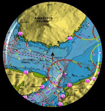
36 Fast Scan and BR24 Improvements Sidelobe Suppression = OFF Sidelobes generated by a Petrol Tank Farm in Auckland with Tall Warship to the right Sidelobe Suppression = AUTO Strong sidelobes are gone with smaller targets and detailed coastlines seen


37 Validation of Radar Software Version Use most current versions ** Version (Available 5/14/10) for BR24 ** Version or later for LRA models


38 Updating of Radar Software Ensure radar is in standby mode prior to updating ** Version (or later )for BR24 -Available 5/14/10 ** Version or later for LRA models Available now
39
40
41
 or time to closest point of approach (TCPA) violates user defined thresholds Benefits Enhances safety via greater situational awareness; Aids in collision avoidance Other")
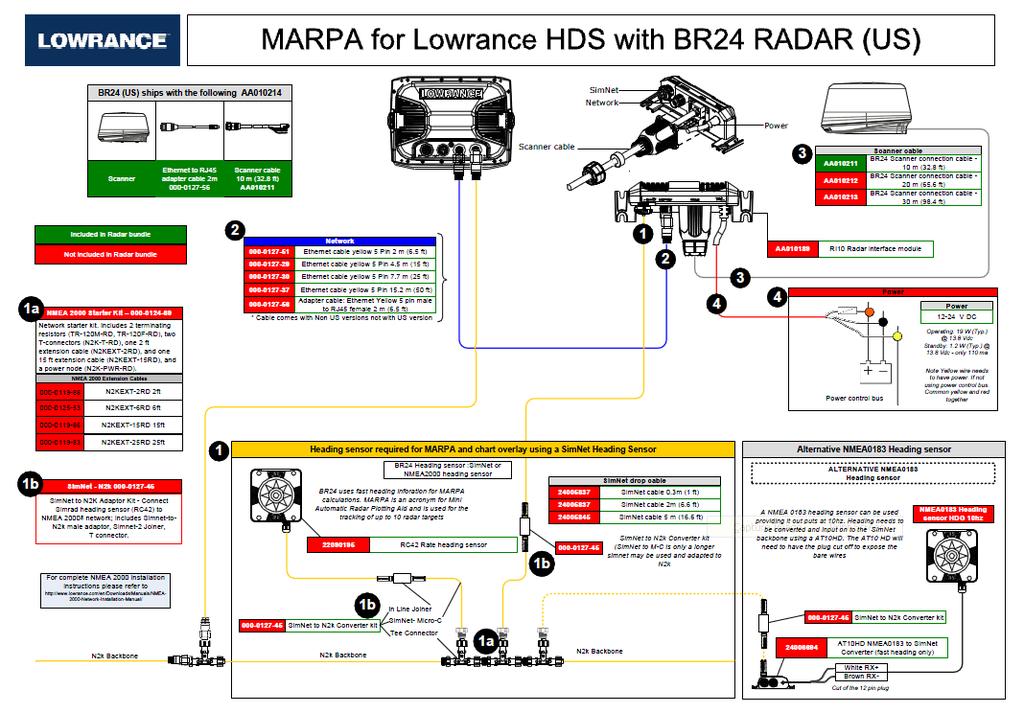
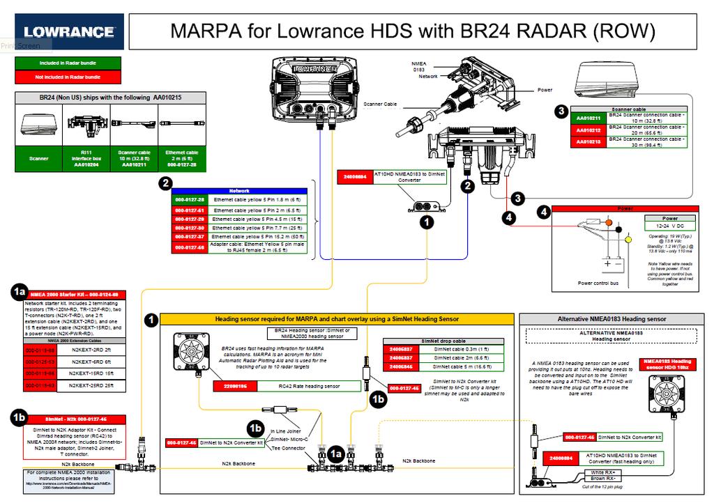
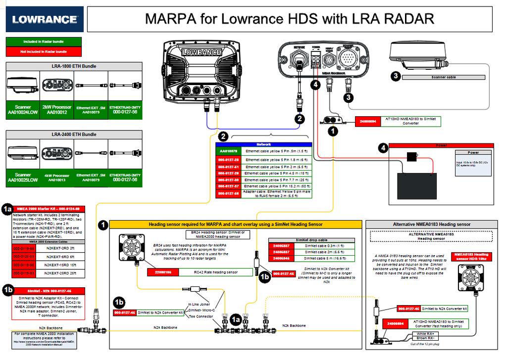
42 MARPA for BR24 and HD Digital Radars Feature Description Mini Automatic Radar Plotting Aid (MARPA) Allows user to acquire and track up to 10 targets and display alarm/warning if closest point of approach (CPA) or time to closest point of approach (TCPA) violates user defined thresholds Benefits Enhances safety via greater situational awareness; Aids in collision avoidance Other Considerations/Equipment Requires external compass heading sensor and RI device. RI device included in non-us SKU s. US SKU s will need to order this RI10 separately. Assigned Target Tracked by Marpa with dotted trail history Fast Boat approaching with easy to see gradient trails Diagrams available to assist in installation Accessibility When in Radar Screen Menu/Acquire Targets

43 MARPA for BR24 and HD Digital CPA and TCPA Feature Settings MARPA uses default or selected CPA (Closest Point of Approach) or TCPA (Time to Closest Point of Approach) to determine if a vessel is safe, dangerous or lost. Radars Definitions Safe not on an approaching path to your vessel Dangerous on an approaching path to your vessel; when a target breaches the selected CPA or TCPA thresholds the target will be classified as dangerous Lost selected target moves out of MARPA range


44 MARPA for BR24 and HD Digital Radars

45 MARPA for BR24 and HD Digital Radars

46 MARPA for BR24 and HD Digital Radars

47 MARPA for BR24 and HD Digital Radars

48 MARPA for BR24 and HD Digital Radars

49 Guard zones for BR24 and HD Digital Radars Feature Description Guard zones allow the user to choose from two easily configurable zone patterns (circular or sector) to define guard areas. Alarm notification is provided to the user as radar targets enter or leave these userdefined areas. Benefits Enhances safety via greater situational awareness; Aids in collision avoidance Other Considerations/Equipment Requires BR24 or compatible HD Digital Radar Accessibility When in Radar Screen Menu/Guard zones

50 Guard zones for BR24 and HD Digital Radars


51 Guard zones for BR24 and HD Digital Radars

52 Mercury SmartCraft Integration Feature Description Provides real time monitoring of Mercury Engine Data on HDS displays. Includes engine RPM, engine voltage, oil & water pressures, fuel flow, and more Benefits Eliminates the need for the consumer/ boat builder to install dedicated gauges to view this information View more information, faster than using standard gauges Other Considerations/Equipment Requires separate purchase of SmartCraft Merc Monitor from Mercury Accessibility Standard NMEA 2000 network setup and activation Some configuration may be required; auto-configuration option is available. More hands-on required for multiple engine set-ups. Info Screen to Display


53 Fuel Prices via Sirius Weather/Radio (US) Feature Description Provides the consumer distance to and up-todate fuel pricing information for fuel stations nearest his current location. User can specify search radius. Benefits Easily identify and find the closest fuel stations Select lowest cost fuel stations Other Considerations/Equipment Requires LWX-1 weather module and subscription US only Land-based stations only; marine based stations not currently included in Sirius database Accessibility Press and hold FIND key on front of unit or Menu/Menu/Fuel
54 Navionics Improvements Feature Heading Extension Adds line extension to vessel. Line distance is projected based on distance or time Fish & Chips Support Display higher detail bathymetric contours from Fish and Chips card. Note that Navigation data is displayed concurrently with this information Last Track Line Drawn (see illustration next page) Upside Down label correction Micro-SD card support Restricted areas Benefit Allows user to project future position based on current bearing and speed. Aid to vessel positioning. To enable use: Menu/Menu/Chart/Heading Extension Fish N Chips offers enhanced sea floor contours for locating ledges and canyons. Aid to fisherman for finding fish and fish holding areas. Bug fix to correct gap between vessel and trail Bug Fix Text now rotates properly in all navigation modes Enables HDS to work with 2010 Navionics Mapping cards on Micro-SD format Users will now be able to hide wildlife sanctuary areas and view items critical for navigation. Default value remains on. When in Chart Menu>Chart Options>Settings> Chart Detail>User Uncheck Restricted Areas

55 Navionics Improvements Last Track Line Drawn Problem Illustration Gap between vessel and trail is fixed in 3.0 release
56 Other Features Feature LGC-4000 Processing Allows HDS units to capture GPS information at 5x / second Low Voltage Alarm Settings Fish Alarm Expanded support of Coordinate Systems and Datum Phantom LORAN Improved Night Mode Synchronized Backlighting Benefit Faster processing of speed and position data on HDS units for improved accuracy. Warns user that battery power is getting low; aids in avoiding getting stranded due to inability to start the engine Audible sound when unit detects fish. Accessible from Sonar Screen under Menu/Sonar Options Restores features set to previous level of functionality available on LMS/LCX products. Accessible via System/Datum and Coordinate Systems Accessible via Navigation Menu Improved operation in 2D chart mode when operating at night. 3D mode not recommended for night operation On networked systems dimming one display or placing it in night mode dims all connected displays


57 Low Voltage Alarm Settings Feature Description Provides visual/audible warning to user when battery supply voltage is low. The threshold voltage at which user is alarmed is settable by the user. Benefits Helps prevents user from getting stranded on the water without sufficient battery power to start engine or call for help. Other Considerations/Equipment No additional equipment required. Default for this setting is OFF (needs to be enabled) Default level for trigger is set at 11 V. Accessibility Menu/Menu/Alarms/Settings


58 Phantom LORAN Feature Description Translates LORAN coordinates into traditional L/L coordinates. Benefits Allows consumer with log book of LORAN coordinates to enter these coordinates into HDS system as you would use any standard coordinate system. Other Considerations/Equipment None Accessibility Menu/Menu/Navigation


59 XTF Support for Structure Feature Description Allows StructureScan users to output log information in alternative file format. Benefits Many 3 rd party applications support XTF file input to aid users in post processing of Side scan sonar data. Other Considerations/Equipment Requires StructureScan capability. Accessibility StructureScan/Log Sonar


60 Night operation in 2D mode Enhancement Night mode operation in 2D provides change in mapping palette. Benefits Ease of use for consumer in reduced light conditions. Helps avoid night blindness Other Considerations/Equipment None Accessibility Power/Night Mode


61 AIS Parameter Setting Enhancement Allows user to filter the number of AIS icons displayed on the screen Benefits Reduces Screen Clutter. Modest speed improvement when using AIS Other Considerations/Equipment AIS Receiver required. Accessibility Menu/Menu/Vessels/Icon Filters
Simulator. Demo mode. Simulator source files. 102 Simulator HDS Gen3 Operator Manual
 13 Simulator The simulation feature lets you see how the unit works in a stationary position and without being connected to sensors or other devices. Demo mode In this mode the unit automatically runs
GPSMAP. 4000/5000 series owner s manual
 GPSMAP 4000/5000 series owner s manual 2009 Garmin Ltd. or its subsidiaries All rights reserved. Except as expressly provided herein, no part of this manual may be reproduced, copied, transmitted, disseminated,
GPSMAP 700 series owner s manual
 GPSMAP 700 series owner s manual Introduction Introduction WARNING See the Important Safety and Product Information guide in the product box for product warnings and other important information. This manual
STRIKER Series. Owner s Manual
 STRIKER Series Owner s Manual Table of Contents Introduction...1 Device Keys... 1 Contacting Garmin Product Support... 1 Selecting the Transducer Type... 1 Zooming on the STRIKER 4... 1 Panning on the
echomap CHIRP 40/50/70/90 Series Owner s Manual
 echomap CHIRP 40/50/70/90 Series Owner s Manual January 2016 190-01951-00_0B All rights reserved. Under the copyright laws, this manual may not be copied, in whole or in part, without the written consent
R2009/R3016 Radar system Quick Reference Card
 R2009/R3016 Radar system Quick Reference Card EN ¼¼ Note: This document covers the products: R2009 Radar system with 9 portrait display, paired with Halo, 3G, 4G or HD radar sensors. R3016 Radar system
GPSMAP 500/700 Series and echomap 50/70 Series Owner s Manual
 GPSMAP 500/700 Series and echomap 50/70 Series Owner s Manual February 2013 190-01556-00_0A Printed in Taiwan All rights reserved. Under the copyright laws, this manual may not be copied, in whole or in
NSE EXPERT NSE12. Rotary controller: Perfectly intuitive for fine or course control of gain, zoom and menu with push to enter functionality
 NSE EXPERT Simrad NSE 8- and 12-inch multifunctional displays provide professional-level performance with sophisticated charting, radar and echosounder technology. With powerful networking and vessel integration
AQUAMAP 80/100 Series Owner s Manual
 AQUAMAP 80/100 Series Owner s Manual April 2014 190-01657-00_0B Printed in Taiwan All rights reserved. Under the copyright laws, this manual may not be copied, in whole or in part, without the written
GPSMAP. 6000/7000 series owner s manual
 GPSMAP 6000/7000 series owner s manual 2010 Garmin Ltd. or its subsidiaries Garmin International, Inc. 1200 East 151 st Street, Olathe, Kansas 66062, USA Tel. (913) 397.8200 or (800) 800.1020 Fax (913)
GMI 10. quick start manual
 GMI 10 quick start manual Introduction The GMI 10 allows you to quickly view important information about your boat provided by connected sensors. Connected sensors transmit data to the GMI 10 using NMEA
GPSMAP. 400/500 series. owner s manual
 GPSMAP 400/500 series owner s manual 2011 Garmin Ltd. or its subsidiaries All rights reserved. Except as expressly provided herein, no part of this manual may be reproduced, copied, transmitted, disseminated,
ARGUS RADAR Quick Reference Card
 ARGUS RADAR Quick Reference Card Own Ship Activated ERBL AIS Symbol ERBL 1 and 2 Helm or Antenna Position Ref. Parallel Index Status/Setup Display Presentation Transceiver Status Tuning Bar Presentation
echomap CHIRP 40/50/70/90 Series Owner s Manual
 echomap CHIRP 40/50/70/90 Series Owner s Manual 2016 2017 Garmin Ltd. or its subsidiaries All rights reserved. Under the copyright laws, this manual may not be copied, in whole or in part, without the
GPSMAP 800/1000 Series
 GPSMAP 800/1000 Series Owner s Manual 2014 2017 Garmin Ltd. or its subsidiaries All rights reserved. Under the copyright laws, this manual may not be copied, in whole or in part, without the written consent
echomap CHIRP 40/50/70/90 Series Owner s Manual
 echomap CHIRP 40/50/70/90 Series Owner s Manual September 2016 190-01951-10_0A All rights reserved. Under the copyright laws, this manual may not be copied, in whole or in part, without the written consent
Installation and Operation Manual
 NAVMAN Tracker 5507/ 5607 Installation and Operation Manual Chartplot ters w w w. n a v m a n. c o m IMPORTANT SAFETY INFORMATION Please read carefully before installation and use. DANGER! WARNING! CAUTION
GPSMAP. 400/500 series. owner s manual
 GPSMAP 400/500 series owner s manual 2010 2011 Garmin Ltd. or its subsidiaries Garmin International, Inc. 1200 East 151st Street, Olathe, Kansas 66062, USA Tel. (913) 397.8200 or (800) 800.1020 Fax (913)
2017 Garmin Ltd. or its subsidiaries All rights reserved. Under the copyright laws, this manual may not be copied, in whole or in part, without the
 Owner's Manual 2017 Garmin Ltd. or its subsidiaries All rights reserved. Under the copyright laws, this manual may not be copied, in whole or in part, without the written consent of Garmin. Garmin reserves
GPSMAP 800/1000 Series Owner s Manual
 GPSMAP 800/1000 Series Owner s Manual June 2014 190-01658-00_0B Printed in Taiwan All rights reserved. Under the copyright laws, this manual may not be copied, in whole or in part, without the written
GPSMAP. 400/500 series. owner s manual
 GPSMAP 400/500 series owner s manual 2010 11 Garmin Ltd. or its subsidiaries Garmin International, Inc. 1200 East 151st Street, Olathe, Kansas 66062, USA Tel. (913) 397.8200 or (800) 800.1020 Fax (913)
GPSMAP. 7400/7600 Series. Owner s Manual. June 2015 Printed in Taiwan _0C
 GPSMAP 7400/7600 Series Owner s Manual June 2015 Printed in Taiwan 190-01841-00_0C All rights reserved. Under the copyright laws, this manual may not be copied, in whole or in part, without the written
Table of Contents. Downloading Garmin Quickdraw Community Maps Garmin Quickdraw Contours Settings... 10
 Owner s Manual Table of Contents Introduction...1 Device Overview... 1 Keys... 1 Tips and Shortcuts... 1 Getting More Information... 1 Inserting Memory Cards... 1 Software Update... 1 Loading the New Software
NC Models. CP390i - GPS Chart Plotters. Addendum to Owner s Manual Issue C to update to Software Version (*)
") CP390i - GPS Chart Plotters (*) NC Models to Owner s Manual Issue 16.50 C 300311 to update to Software Version 16.70 BUILT-IN CHARTS ARE NOT INSTALLED The following paragraphs/pictures are not applicable:
CP390i - GPS Chart Plotters (*) NC Models to Owner s Manual Issue 16.50 C 300311 to update to Software Version 16.70 BUILT-IN CHARTS ARE NOT INSTALLED The following paragraphs/pictures are not applicable:
dkart Navigator 9010
 dkart Navigator 9010 dkart Navigator - purpose dkart Navigator is an electronic navigation chart system specially designed to facilitate all the navigational tasks of mariner's day-to-day practice. Along
GPSMAP 7400/7600 Series
 GPSMAP 7400/7600 Series Owner s Manual 2014 2017 Garmin Ltd. or its subsidiaries All rights reserved. Under the copyright laws, this manual may not be copied, in whole or in part, without the written consent
R2009/R3016 User Manual
 R2009/R3016 User Manual ENGLISH navico-commercial.com Preface Disclaimer As Navico is continuously improving this product, we retain the right to make changes to the product at any time which may not
STRIKER Series. Owner s Manual
 STRIKER Series Owner s Manual June 2016 190-01950-26 Rev. C All rights reserved. Under the copyright laws, this manual may not be copied, in whole or in part, without the written consent of Garmin. Garmin
Easy. Touch. Simrad NSS Touch-Screen Multifunction Displays
 Easy. Touch. Simrad NSS Touch-Screen Multifunction Displays A Touch simpler. SIMRAD NSS Introducing NSS. Incorporating outstanding Simrad Touch Sensible technology, the all-new NSS Sport is the touch-screen
GPSMAP 7400/7600 Series
 GPSMAP 7400/7600 Series Owner s Manual Table of Contents Introduction...1 Device Overview... 1 Using the Touchscreen... 1 On-Screen Buttons... 1 Tips and Shortcuts... 1 Locking and Unlocking the Touchscreen...
Eighth Annual QUIKLOOK Users Group Meeting
 Eighth Annual QUIKLOOK Users Group Meeting Marion, MA August 20 & 21st, 2014 Eric Solla QUIKLOOK Product Manager Quiklook Software Update Version 2013.256 Released August 2013 Quiklook II Version 2013.309
Explorer 657. Fishfinder and Chartplotter Installation and Operation Manual.
 Explorer 657 Fishfinder and Chartplotter Installation and Operation Manual www.northstarnav.com IMPORTANT SAFETY INFORMATION Please read carefully before installation and use. DANGER! WARNING! CAUTION
GPSMAP 8400/8600 Series
 GPSMAP 8400/8600 Series Owner s Manual Table of Contents Introduction...1 Device Overview... 1 Using the Touchscreen... 1 On-Screen Buttons... 1 Tips and Shortcuts... 1 Locking and Unlocking the Touchscreen...
GPSMAP 4000/5000 Series. owner s manual
 GPSMAP 4000/5000 Series owner s manual 2008 Garmin Ltd. or its subsidiaries Garmin International, Inc. 1200 East 151st Street, Olathe, Kansas 66062, USA Tel. (913) 397.8200 or (800) 800.1020 Fax (913)
echo 100 and echo 150 owner s manual
 echo 100 and echo 150 owner s manual Introduction Introduction Warning See the Important Safety and Product Information guide in the product box for product warnings and other important information. This
GPSMAP 1000/1200 SERIES. Owner s Manual
 GPSMAP 1000/1200 SERIES Owner s Manual 2016 2018 Garmin Ltd. or its subsidiaries All rights reserved. Under the copyright laws, this manual may not be copied, in whole or in part, without the written consent
ECHOMAP 40/60/70/90 SERIES. Owner s Manual
 ECHOMAP 40/60/70/90 SERIES Owner s Manual 2017 Garmin Ltd. or its subsidiaries All rights reserved. Under the copyright laws, this manual may not be copied, in whole or in part, without the written consent
E-Series Display Operating Guide
 E-Series Display Operating Guide www.raymarine.com PAGE ACTIVE WPTS MOB DATA MENU General Operation OK OUT RANGE IN CANCEL The control panel Using the controls Setting up the display Using CompactFlash
Q Panel General Guide
 Q Panel General Guide Contents Q Panel General Guide Welcome to Q Experience! Available applications Tech overview Overview Quick Start Applications Elements: Sidebar Sidebar: Modes Elements: Main menu
GPSMAP 1000/1200 SERIES. Owner s Manual
 GPSMAP 1000/1200 SERIES Owner s Manual 2016 Garmin Ltd. or its subsidiaries All rights reserved. Under the copyright laws, this manual may not be copied, in whole or in part, without the written consent
Owners. manual VOLVO PENTA GLASS COCKPIT
 Owners manual VOLVO PENTA GLASS COCKPIT 2013 2017 Garmin Ltd. or its subsidiaries All rights reserved. Under the copyright laws, this manual may not be copied, in whole or in part, without the written
Quick Start Guide V1.1
 X-Pilot autopilot for bait boats Quick Start Guide V1.1 www.toslon.com 1. What s on the display & Keypad instruction 6 7 8 9 10 13 14 15 16 5 4 12.1V 10 1.1 m/s 2 86.5m 10 4 deg 11 275.2m 1.2m/s 18 deg
JMA-3300 Radar. Semi-Constaview digital signal processing inch ultra bright LCD New System-on-Chip technology
 JMA-3300 Radar JRC s new radar incorporates the latest leading technologies 10.4-inch ultra bright LCD New System-on-Chip technology Semi-Constaview digital signal processing AIS and MARPA+ as standard
GPSMAP 7400/7600 Series
 GPSMAP 7400/7600 Series Owner s Manual 2014 2017 Garmin Ltd. or its subsidiaries All rights reserved. Under the copyright laws, this manual may not be copied, in whole or in part, without the written consent
GPSMAP 4000 Series. owner s manual
 GPSMAP 4000 Series owner s manual 2008 Garmin Ltd. or its subsidiaries Garmin International, Inc. 1200 East 151st Street, Olathe, Kansas 66062, USA Tel. (913) 397.8200 or (800) 800.1020 Fax (913) 397.8282
GPSMAP 8000/8500 SERIES. Owner s Manual
 GPSMAP 8000/8500 SERIES Owner s Manual 2013 2017 Garmin Ltd. or its subsidiaries All rights reserved. Under the copyright laws, this manual may not be copied, in whole or in part, without the written consent
GPSMAP 702/902 SERIES. Owner s Manual
 GPSMAP 702/902 SERIES Owner s Manual 2016 2017 Garmin Ltd. or its subsidiaries All rights reserved. Under the copyright laws, this manual may not be copied, in whole or in part, without the written consent
GPSMAP 5000 Series. owner s manual
 GPSMAP 5000 Series owner s manual 2007 Garmin Ltd. or its subsidiaries Garmin International, Inc. 1200 East 151 st Street, Olathe, Kansas 66062, USA Tel. (913) 397.8200 or (800) 800.1020 Fax (913) 397.8282
GPSMAP 702/902 SERIES. Owner s Manual
 GPSMAP 702/902 SERIES Owner s Manual 2016 2018 Garmin Ltd. or its subsidiaries All rights reserved. Under the copyright laws, this manual may not be copied, in whole or in part, without the written consent
SPECIFICATIONS SUBJECT TO CHANGE WITHOUT NOTICE PLEASE READ MANUAL BEFORE USING THE UNIT 12035SK Printed in Japan Catalogue No.
 www.furuno.com All brand and product names are registered trademarks, trademarks or service marks of their respective holders. SPECIFICATIONS SUBJECT TO CHANGE WITHOUT NOTICE PLEASE READ MANUAL BEFORE
Technical Reference. for Garmin NMEA 2000 Products + -
 Technical Reference for Garmin NMEA 2000 Products + - Introduction Introduction A NMEA 2000 network consists of connected NMEA 2000 devices that communicate using basic plug-and-play functionality. This
360 Imaging. Operations Manual _B
 360 Imaging Operations Manual 532074-2_B Thank You! Thank you for choosing Humminbird, the #1 name in marine electronics. Humminbird has built its reputation by designing and manufacturing top-quality,
CHIRP RADAR. HELIX Operations Manual EN_A
 CHIRP RADAR HELIX Operations Manual 532547-1EN_A THANK YOU! Thank you for choosing Humminbird, the #1 name in marine electronics. Humminbird has built its reputation by designing and manufacturing top
rino 600 series quick start manual
 rino 600 series quick start manual Getting Started Keys warning See the Important Safety and Product Information guide in the product box for product warnings and other important information. When using
Owners. manual VOLVO PENTA GLASS COCKPIT
 Owners manual VOLVO PENTA GLASS COCKPIT 2016 2017 Garmin Ltd. or its subsidiaries All rights reserved. Under the copyright laws, this manual may not be copied, in whole or in part, without the written
Explorer 660 Chartplotter and Fishfinder Installation and Operation Manual
 Explorer 660 Chartplotter and Fishfinder Installation and Operation Manual www.northstarnav.com IMPORTANT SAFETY INFORMATION Please read carefully before installation and use. DANGER! WARNING! CAUTION
NEW FOR Radar. Broadband. The evolution of the radar revolution.
 NEW FOR 2011 Broadband Radar The evolution of the radar revolution. The evolution of the radar revolution. The original BR24 Broadband Radar, the frequency modulated continuous wave (FMCW) radar, has captured
Manual. Simrad NX40/45 NavStation. English Sw. 2.7
 Manual Simrad NX40/45 NavStation English Sw. 2.7 www.simrad-yachting.com A brand by Navico - Leader in Marine Electronics Warning It is your sole responsibility to install and use the instrument and transducer(s)
TRADEMARK REGISTERED SPECIFICATIONS SUBJECT TO CHANGE WITHOUT NOTICE 1201XSK Printed in Japan Catalogue No. R-201
 T o t a l C o n t r o l a t y o u r F i n g e r t i p s www.furuno.com All brand and product names are registered trademarks, trademarks or service marks of their respective holders. Alpha blending technology
S! Applications & Widgets
 S! Appli...-2 Using S! Applications... -2 Mobile Widget... -3 Customizing Standby Display (Japanese)... -3 Additional Functions... -6 Troubleshooting... - S! Applications & Widgets -1 S! Appli Using S!
GR16 GPS Receiver Accessory Manual _B
 GR16 GPS Receiver Accessory Manual 531478-1_B Thank You! Thank you for choosing Humminbird, America's #1 name in fishfinders. Humminbird has built its reputation by designing and manufacturing top-quality,
Owner s Manual GPSMAP 3006C/3010C
 Owner s Manual GPSMAP 3006C/3010C Copyright 2004, 2005, 2006 Garmin Ltd. or its subsidiaries Garmin International, Inc. 1200 East 151 st Street, Olathe, Kansas 66062, USA Tel. (913) 397.8200 or (800) 800.1020
Introduction...2 Content...2 Multi-Function Display Software Update...2 AIS Overview...2
 SKIPPERS NOTES Yacht Sea Essay of Hamble Newsletter No 02/16 Introduction This is an occasional document issued by the Yacht Secretary, which will be placed on the CSD website and/or sent to all CSSA approved
GPS Receiver _B
 GPS Receiver 531478-2_B Thank You! Thank you for choosing Humminbird, America's #1 name in Fishfinders. Humminbird has built its reputation by designing and manufacturing top-quality, thoroughly reliable
The operator interface consists of an LCD and eight keys. Use the interface to program and operate the triggering controller.
 Nordson Corporation OPERATOR S CARD P/N 1017461C Sure Coat Triggering Controller Operator Interface WARNING: Allow only qualified personnel to perform the following tasks. Follow the safety instructions
CHART PLOTTER NAME DESCRIPTION SOFTWARE
 CHART PLOTTER NAME DESCRIPTION SOFTWARE S-50.0 5" Sunlight Readable Vertical Color Display S4xgTM5vc External Smart GPS Receiver S-55.0 5" Sunlight Readable Vertical Color Display S4xgTM5vc Internal GPS
User Manual code: (A e)
") CHART PLOTTER NAME DESCRIPTION SOFTWARE EC5E 5" Sunlight Readable Vertical Color Display S4x2SW5vc External Smart GPS Receiver EC5I 5" Sunlight Readable Vertical Color Display S4x2SW5vc Internal GPS Receiver
CHART PLOTTER NAME DESCRIPTION SOFTWARE EC5E 5" Sunlight Readable Vertical Color Display S4x2SW5vc External Smart GPS Receiver EC5I 5" Sunlight Readable Vertical Color Display S4x2SW5vc Internal GPS Receiver
586c HD, 596c HD, and 596c HD DI. Operations Manual EN_B. Section Title
 586c HD, 596c HD, and 596c HD DI Operations Manual 531819-2EN_B A Section Title Thank You! Thank you for choosing Humminbird, the #1 name in fishfinders. Humminbird has built its reputation by designing
HSB Series LCD Display Owner s Handbook
 HSB Series LCD Display Owner s Handbook Document number: 81163_1 Date: 1st September 1999 Preface i HSB Series LCD Display Owner s Handbook September 1999 SAFETY NOTICES This radar equipment must be installed
G142C and G142CFD INSTRUCTION MANUAL.
 G142C and G142CFD INSTRUCTION MANUAL www.gme.net.au Important It is the owner s sole responsibility to install and use the unit in a manner that will not cause accidents, personal injury or property damage.
Owner s Manual GPSMAP 2106/2110
 Owner s Manual GPSMAP 2106/2110 2006 Garmin Ltd. or its subsidiaries Garmin International, Inc. 1200 East 151 st Street, Olathe, Kansas 66062, USA Tel. (913) 397.8200 or (800) 800.1020 Fax (913) 397.8282
PolNav the state-of-the-art navigation software (Version: 2008 R5)
") PolNav the state-of-the-art navigation software (Version: 2008 R5) 1 PolNav Fast, Intuitive, Neverlost, Easy-to-use, Advanced Navigation 2 Map Display 3 Enriched Map Area/River/Railway House Number Scheme
PolNav the state-of-the-art navigation software (Version: 2008 R5) 1 PolNav Fast, Intuitive, Neverlost, Easy-to-use, Advanced Navigation 2 Map Display 3 Enriched Map Area/River/Railway House Number Scheme
LAKEMASTER GUIDE. Spend less time searching and more time fishing GETTING STARTED...3,4
 2013 user guide LAKEMASTER GUIDE Spend less time searching and more time fishing Combine innovative LakeMaster Digital GPS Maps with groundbreaking Humminbird sonar and Minn Kota i-pilot Link to easily
AIS6 / MFR6 User Manual
 AIS6 / MFR6 User Manual Important Features at a glance Below you will find a brief summary of the main features of your Seatec AIS6 / MFR6. Your Seatec AIS6 / MFR6 will be your reliable partner for a safe
Installation and Operation Manual
 www.navman.com Tracker 5430/5430i Pilot 3380 C H A RA TU PT LO OP T I TL EO R T Installation and Operation Manual FCC Statement Note: This equipment has been tested and found to comply with the limits
THE ELECTRONIC CHART DISPLAY AND INFORMATION SYSTEM (ECDIS) IN CHINA
 IN CHINA") International Hydrographic 'Review, Monaco, LXIX(2), September 1992 THE ELECTRONIC CHART DISPLAY AND INFORMATION SYSTEM (ECDIS) IN CHINA by The Research Group on ECDIS 1 Abstract This paper presents a
International Hydrographic 'Review, Monaco, LXIX(2), September 1992 THE ELECTRONIC CHART DISPLAY AND INFORMATION SYSTEM (ECDIS) IN CHINA by The Research Group on ECDIS 1 Abstract This paper presents a
KMD 550/850. Traffic Avoidance Function (TCAS/TAS/TIS) Pilot s Guide Addendum. Multi-Function Display. For Software Version 01/13 or later
 Pilot s Guide Addendum. Multi-Function Display. For Software Version 01/13 or later") N B KMD 550/850 Multi-Function Display Traffic Avoidance Function (TCAS/TAS/TIS) Pilot s Guide Addendum For Software Version 01/13 or later Revision 3 Jun/2004 006-18238-0000 The information contained
N B KMD 550/850 Multi-Function Display Traffic Avoidance Function (TCAS/TAS/TIS) Pilot s Guide Addendum For Software Version 01/13 or later Revision 3 Jun/2004 006-18238-0000 The information contained
NEW. Multifunction Displays. GPS Radar Sonar Thermal Imaging Wireless AIS Weather
 NEW Multifunction Displays GPS Radar Sonar Thermal Imaging Wireless AIS Weather TM Navigation Simplified Charts Included Radar Video Clear Pulse Sonar 12.1 WEATHER SIRIUS Marine Weather 7 Thermal Night
SCOUT Mobile User Guide 3.0
 SCOUT Mobile User Guide 3.0 Android Guide 3864 - SCOUT February 2017 SCOUT Mobile Table of Contents Supported Devices...1 Multiple Manufacturers...1 The Three Tabs of SCOUT TM Mobile 3.0...1 SCOUT...1
Suitable firmware can be found on Anritsu's web site under the instrument library listings.
 General Caution Please use a USB Memory Stick for firmware updates. Suitable firmware can be found on Anritsu's web site under the instrument library listings. If your existing firmware is older than v1.19,
echo 100 and echo 150 owner s manual
 echo 100 and echo 150 owner s manual 2011 Garmin Ltd. or its subsidiaries All rights reserved. Except as expressly provided herein, no part of this manual may be reproduced, copied, transmitted, disseminated,
Pokémon Art Academy. Basic Information. Starting the Game. Drawing. Viewing Artwork
 Pokémon Art Academy 1 Important Information Basic Information 2 Information Sharing 3 Online Features 4 Parental Controls Starting the Game 5 Getting Started 6 Saving and Deleting Data Drawing 7 Controls
Online - Display and CommandARM TM Simulator. Help Guide
 Online - Display and CommandARM TM Simulator Help Guide GS2 1800 Display GS3 CommandCenter TM Display GS3 2630 Display Generation 4 CommandCenter TM Display Last Updated: January 2017 Applies to Online
Astro. New cover and photo requested... and DC 40 draft owner s manual. GPS-enabled dog tracking
 Astro and DC 40 draft owner s manual New cover and photo requested... GPS-enabled dog tracking 2010 Garmin Ltd. or its subsidiaries All rights reserved. Except as expressly provided herein, no part of
ICS NAV6 range. User Guide
 ICS NAV6 range User Guide Important Information This equipment is not approved for use by SOLAS convention vessels within the Global Maritime Distress and Safety System (GMDSS) It is intended for use by
New Software v2.0.3 INDEX. Model: GP1870F. 1. Wireless Solution (Model: GP1870F only) 3-3 Suppressing 0 from Point Name Indication
 3-3 Suppressing 0 from Point Name Indication") Model: GP1670F Model: GP1870F New Software v2.0.3 1. Wireless Solution (Model: GP1870F only) 1-1 Weather Information by C-Weather 1-2 Chart Plotter Link by Plan2Nav App 1-3 Important Notice on Wireless
Model: GP1670F Model: GP1870F New Software v2.0.3 1. Wireless Solution (Model: GP1870F only) 1-1 Weather Information by C-Weather 1-2 Chart Plotter Link by Plan2Nav App 1-3 Important Notice on Wireless
Target intensity is shown in colour shades to assist the operator in differentiating between large and small vessels and weather severity.
 SWR1 - RADAR SCANNER (1 2Kw 24NM 0,9 Feet) maybe the smallest in the Seiwa range of radars but SWR-1 comes with the same host of features as it larger relatives providing a safer navigation in all weather
Rino 750/755t. Owner s Manual
 Rino 750/755t Owner s Manual 2016 Garmin Ltd. or its subsidiaries All rights reserved. Under the copyright laws, this manual may not be copied, in whole or in part, without the written consent of Garmin.
RLS2. Owner s Manual. Portable All-Band Radar and Laser Detector with GPS Technology
 RLS2 Owner s Manual Portable All-Band Radar and Laser Detector with GPS Technology K40 Consult Don t like to read manuals? Call our experienced K40 Consultants. We ll explain the whole thing. 800.323.5608
500 Series Operations Manual EN_A
 500 Series Operations Manual 531716-6EN_A Thank You! Thank you for choosing Humminbird, the #1 name in marine electronics. Humminbird has built its reputation by designing and manufacturing top-quality,
Simrad CE40/42/50 MKII DGPS ChartSounder
 Simrad CE40/42/50 MKII DGPS ChartSounder 183.0100.202 English 01154.05 Note! Insert or remove C-MAP cartridges ONLY through CHART menu or when unit is off. All electronic navigation equipment is subject
ADMS-847 Programming Software for the Yaesu FT-847
 for the Yaesu FT-847 Memory Types Memories Limit Memories VFO A VFO B Home Satellite Memories One Touch Memory Channel Functions Transmit Frequency Offset Frequency Offset Direction CTCSS DCS Skip The
CAST Application User Guide
 CAST Application User Guide for DX900+ Electromagnetic Multilog Sensor U.S. Patent No. 7,369,458. UK 2 414 077. Patents Pending 17-630-01-rev.b 05/24/17 1 Copyright 2017 Airmar Technology Corp. All rights
RINO 700. Owner s Manual
 RINO 700 Owner s Manual 2017 Garmin Ltd. or its subsidiaries All rights reserved. Under the copyright laws, this manual may not be copied, in whole or in part, without the written consent of Garmin. Garmin
User Guide: PTT Application - Android. User Guide. PTT Application. Android. Release 8.3
 User Guide PTT Application Android Release 8.3 March 2018 1 1. Introduction and Key Features... 6 2. Application Installation & Getting Started... 7 Prerequisites... 7 Download... 8 First-time Activation...
The GPS Classroom. Jared Covili
 The GPS Classroom Jared Covili 1/17/06 2 The GPS Classroom Jared Covili jcovili@media.utah.edu (801) 585-5667 The GPS Classroom is a 2-day course that provides participants with the basic knowledge of
GMR 20/40 Marine Radar Owner s Manual
 GMR 20/40 Marine Radar Owner s Manual Copyright 2005 Garmin Ltd. or its subsidiaries Garmin International, Inc. 1200 East 151 st Street, Olathe, Kansas 66062, U.S.A. Tel. 913/397.8200 or 800/800.1020 Fax
WCS-D5100 Programming Software for the Icom ID-5100 Data
 WCS-D5100 Programming Software for the Icom ID-5100 Data Memory Types (left to right) Memories Limit Memories DR Memories Call Channels GPS Memories Receive Frequency Transmit Frequency Offset Frequency
32 Float v3 Quick Start Guide. AUTHORED BY ANTHONY HERNANDEZ (415)
") 32 Float v3 Quick Start Guide 32 Float v3 Trademark/Copyright Information Copyright 2013 by United Color Technologies, LLC. All rights reserved. Unified Color Technologies, BeyondRGB, and HDR Expose are
32 Float v3 Quick Start Guide 32 Float v3 Trademark/Copyright Information Copyright 2013 by United Color Technologies, LLC. All rights reserved. Unified Color Technologies, BeyondRGB, and HDR Expose are
SKF TKTI. Thermal Camera Software. Instructions for use
 SKF TKTI Thermal Camera Software Instructions for use Table of contents 1. Introduction...4 1.1 Installing and starting the Software... 5 2. Usage Notes...6 3. Image Properties...7 3.1 Loading images