On multipath characterization through software receivers and ray-tracing
|
|
|
- Ilene Logan
- 6 years ago
- Views:
Transcription

, TU Braunschweig Geodätische Woche Nürnberg 27.-29.")
1 On multipath characterization through software receivers and ray-tracing Marios Smyrnaios 1, Steffen Schön 1, Marcos Liso 2, Thomas Kürner 2 1 Institut für Erdmessung (IfE), Leibniz-Universität Hannover 2 Institut für Nachrichtentechnik (IfN), TU Braunschweig Geodätische Woche Nürnberg

2 Motivation Multipath rays distort the correlation function during tracking Correlation output is fed into the code and carrier tracking loops Correlation output is used for C/N 0 calculation Impact on C/N 0 observables is investigated and compared with the results from a ray-tracing approach Carrier phase error Code phase error C/N0 amplitude variations 2
3 Factors having an impact on C/N 0 C/N 0 and Multipath Prompt correlator is used for the estimation of the C/N 0 Multipath rays distort the correlation output (composite signal) Multipath rays affect the C/N 0 values and create amplitude variations Ray-tracing can describe the characteristics of reflected rays Other factors influencing C/N 0 Antenna characteristics Coherent integration time Loop filter bandwidth C/N 0 estimation method With software receivers the above factors can be investigated 3
")
4 Scenario The more accurate the description of the physical environment of the receiver, the more accurate the channel estimation Scenario: Measured by a terrestrial laser scanner (Z+F Imager 5006) Scenario formed by 783 rectangles, 35 box shapes and 99 cylinders Coordinates of all planes are known with mm accuracy Material properties of all planes are known GIH building rooftop (source: GIH) Weather information 4


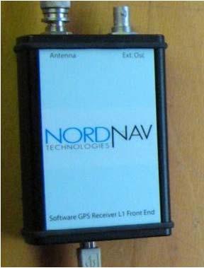
5 Experiment Date Data Antenna Raw observations + IF Leica AX1202GG Raw observations + IF Leica AX1202GG Raw observations + IF Leica AX1202GG Raw observations + IF Leica AR Raw observations + IF Leica AR Raw observations + IF Leica AR25 Javad G3T Delta Leica GRX1200 +GNSS Nord Nav R30 5
6 Experiment setup antenna splitter ~13 m DC blocker Leica Leica Javad Nord Nav Javad RINEX data processing: Matlab based modules developed at Institut für Erdmessung IF data pocessing: Nord Nav firmware Matlab based software receiver modules for C/N 0 estimation developed at Institut für Erdmessung 6


7 C/N 0 output of the receivers Data captured on at 14:06:00 Duration 1 hour Javad G3T Delta Leica GRX1200 +GNSS Nord Nav R30 Mean elevation: PRN2 35 PRN7 63 PRN


8 C/N 0 estimators vs Nord Nav C/No values Nord Nav R30 vs Elevation angle between 40 and 35? Elevation angle between 70 and 75 Power Ratio estimator vs Variance Summing estimator vs Squaring estimator vs Differential estimator 8
")
9 Different integration times and averaging periods T=1msec, rate=0,5 sec T=5msec, rate=0,5 sec T=10msec, rate=0,5 sec T=1msec, rate=4 sec T=5msec, rate=4 sec T=10msec, rate=4sec Variance Summing estimator (1 hour IF data set) 9

10 Sidereal repeatability Mean offset value: db-hz and σ=0.443 db-hz Date Start time End time :22:08 15:18: :09:56 15:06:41 10

11 Ray-tracing results for PRN 2 11
 PRN 2 ground multipath Ground multipath")
12 Ray-tracing results ( ) PRN 2 ground multipath Ground multipath identified for 11 min 50 sec m 12

13 C/N 0 observed vs simulated M. Liso et al. 2011* M. Liso et al. 2011* Simulation follows the measurements but not the power oscillations Direct signal dominates and multipath signals are very weak * M. Liso Nicolas, M. Jacob, M. Smyrnaios, S. Schön, T. Kürner, Basic Concepts for the Modeling and Correction of GNSS Multipath Effects using Ray Tracing and Software Receivers,
14 Conclusion-Future work Different receivers C/N 0 output time series Different coherent integration intervals and different averaging periods Comparison with first results from a Ray-Tracing approach Diffraction will be taken into account, as well as second order reflections Characteristic cases are to be investigated e.g. maximum error in signal amplitude results in minimum phase multipath Impact on phase observations Acknowledgements: We d like to acknowledge GFZ Potsdam and DLR GSOC for providing their Nord Nav receivers for the measurement campaigns. This work is funded by the German Aerospace Center (DLR) in the framework of BERTA project. 14
A Zeppelin-based Study on GNSS Reflectometry for Altimetric Application
 A Zeppelin-based Study on GNSS Reflectometry for Altimetric Application M. Semmling 1 G. Beyerle 1 J. Beckheinrich 1 J. Wickert 1 M. Ge 1 S. Schön 2 1 GFZ Deutsches GeoForschungsZentrum, Potsdam 2 IfE
Characterization of GOCE GPS Antennas
 Characterization of GOCE GPS Antennas Florian Dilßner, Günter Seeber (IfE), Universität Hannover, Germany Martin Schmitz, Gerhard Wübbena Geo++ GmbH, Garbsen, Germany Giovanni Toso, Damien Maeusli European
Determination of refractivity variations with GNSS and ultra-stable frequency standards
 Determination of refractivity variations with GNSS and ultra-stable frequency standards Markus Vennebusch, Steffen Schön, Ulrich Weinbach Institut für Erdmessung (IfE) / Institute of Geodesy Leibniz-Universität
Carrier Phase Multipath Corrections Based on GNSS Signal Quality Measurements to Improve CORS Observations
 Carrier Phase Multipath Corrections Based on GNSS Signal Quality Measurements to Improve CORS Observations Christian Rost and Lambert Wanninger Geodetic Institute Technische Universität Dresden Dresden,
GNSS Reflectometry: Innovative Remote Sensing
 GNSS Reflectometry: Innovative Remote Sensing J. Beckheinrich 1, G. Beyerle 1, S. Schön 2, H. Apel 1, M. Semmling 1, J. Wickert 1 1.GFZ, German Research Center for Geosciences, Potsdam, Germany 2.Leibniz
AIRPORT MULTIPATH SIMULATION AND MEASUREMENT TOOL FOR SITING DGPS REFERENCE STATIONS
 AIRPORT MULTIPATH SIMULATION AND MEASUREMENT TOOL FOR SITING DGPS REFERENCE STATIONS ABSTRACT Christophe MACABIAU, Benoît ROTURIER CNS Research Laboratory of the ENAC, ENAC, 7 avenue Edouard Belin, BP
HIGH GAIN ADVANCED GPS RECEIVER
 ABSTRACT HIGH GAIN ADVANCED GPS RECEIVER NAVSYS High Gain Advanced () uses a digital beam-steering antenna array to enable up to eight GPS satellites to be tracked, each with up to dbi of additional antenna
Project: IEEE P Working Group for Wireless Personal Area Networks (WPANs)
") Project: IEEE P802.15 Working Group for Wireless Personal Area Networks (WPANs) Title: Link Level Simulations of THz-Communications Date Submitted: 15 July, 2013 Source: Sebastian Rey, Technische Universität
Project: IEEE P802.15 Working Group for Wireless Personal Area Networks (WPANs) Title: Link Level Simulations of THz-Communications Date Submitted: 15 July, 2013 Source: Sebastian Rey, Technische Universität
ABSOLUTE CALIBRATION OF TIME RECEIVERS WITH DLR'S GPS/GALILEO HW SIMULATOR
 ABSOLUTE CALIBRATION OF TIME RECEIVERS WITH DLR'S GPS/GALILEO HW SIMULATOR S. Thölert, U. Grunert, H. Denks, and J. Furthner German Aerospace Centre (DLR), Institute of Communications and Navigation, Oberpfaffenhofen,
Orion-S GPS Receiver Software Validation
 Space Flight Technology, German Space Operations Center (GSOC) Deutsches Zentrum für Luft- und Raumfahrt (DLR) e.v. O. Montenbruck Doc. No. : GTN-TST-11 Version : 1.1 Date : July 9, 23 Document Title:
Bouncing off Walls and Trees: Multipath Channel Modeling for Satellite Navigation from the Samples Point of View
 Bouncing off Walls and Trees: Multipath Channel Modeling for Satellite Navigation from the Samples Point of View F. M. Schubert German Aerospace Center (DLR) Institute for Communications and Navigation
Satellite Navigation Principle and performance of GPS receivers
 Satellite Navigation Principle and performance of GPS receivers AE4E08 GPS Block IIF satellite Boeing North America Christian Tiberius Course 2010 2011, lecture 3 Today s topics Introduction basic idea
TEST RESULTS OF A HIGH GAIN ADVANCED GPS RECEIVER
 TEST RESULTS OF A HIGH GAIN ADVANCED GPS RECEIVER ABSTRACT Dr. Alison Brown, Randy Silva, Gengsheng Zhang,; NAVSYS Corporation. NAVSYS High Gain Advanced GPS Receiver () uses a digital beam-steering antenna
Reduction of Pseudorange Multipath Error in Static Positioning. Tokyo University of Mercantile Marine Nobuaki Kubo Akio Yasuda
 Reduction of Pseudorange Multipath Error in Static Positioning Tokyo University of Mercantile Marine Nobuaki Kubo Akio Yasuda Brief Many researchers have tried to reduce the multipath effect from both
Assessment of high-rate GPS using a single-axis shake table
 Assessment of high-rate GPS using a single-axis shake table S. Häberling, M. Rothacher, A. Geiger Institute of Geodesy and Photogrammetry, ETH Zurich Introduction Project: Study the applicability of high-rate
GPS PERFORMANCE EVALUATION OF THE HUAWEI MATE 9 WITH DIFFERENT ANTENNA CONFIGURATIONS
 GPS PERFORMANCE EVALUATION OF THE HUAWEI MATE 9 WITH DIFFERENT ANTENNA CONFIGURATIONS AND P10 IN THE FIELD Gérard Lachapelle & Research Team PLAN Group, University of Calgary (http://plan.geomatics.ucalgary.ca)
Navigation für herausfordernde Anwendungen Robuste Satellitennavigation für sicherheitskritische Anwendungen
 www.dlr.de Chart 1 Navigation für herausfordernde Anwendungen Robuste Satellitennavigation für sicherheitskritische Anwendungen PD Dr.-Ing. habil. Michael Meurer German Aerospace Centre (DLR), Oberpfaffenhofen
Submission Title: Study on Statistical Characteristics of Human Blockage Effects in Future Indoor Millimeter Wave and THz Wireless Communications
 Project: IEEE P802.15 Working Group for Wireless Personal Area Networks (WPANs) Title: Study on Statistical Characteristics of Human Blockage Effects in Future Indoor Millimeter Wave and THz Wireless Communications
April - 1 May, Evolution to Modernized GNSS Ionospheric Scintillation and TEC Monitoring
 2333-1 Workshop on Science Applications of GNSS in Developing Countries (11-27 April), followed by the: Seminar on Development and Use of the Ionospheric NeQuick Model (30 April-1 May) 11 April - 1 May,
Utilizing Batch Processing for GNSS Signal Tracking
 Utilizing Batch Processing for GNSS Signal Tracking Andrey Soloviev Avionics Engineering Center, Ohio University Presented to: ION Alberta Section, Calgary, Canada February 27, 2007 Motivation: Outline
doc.: IEEE thz_Channel_Characteristics_Study_100GHz_300GHz
 Project: IEEE P802.15 Working Group for Wireless Personal Area Networks (WPANs) Submission Title: Channel Characteristics Study for Future Indoor Millimeter And Submillimeter Wireless Communications Date
Prototype Software-based Receiver for Remote Sensing using Reflected GPS Signals. Dinesh Manandhar The University of Tokyo
 Prototype Software-based Receiver for Remote Sensing using Reflected GPS Signals Dinesh Manandhar The University of Tokyo dinesh@qzss.org 1 Contents Background Remote Sensing Capability System Architecture
Signal Quality Checks For Multipath Detection in GNSS
 Signal Quality Checks For Multipath Detection in GNSS Diego M. Franco-Patiño #1, Gonzalo Seco-Granados *2, and Fabio Dovis #3 # Dipartimento di Elettronica e Telecomunicazioni, Politecnico di Torino Corso
An Analysis of the Short- Term Stability of GNSS Satellite Clocks
 An Analysis of the Short- Term Stability of GNSS Satellite Clocks Erin Griggs, Dr. Rob Kursinski, Dr. Dennis Akos Aerospace Engineering Sciences University of Colorado 1 MOTIVATION 2 Radio Occulta.on Status
Release: The contributor acknowledges and accepts that this contribution becomes the property of IEEE and may be made publicly available by P
 Project: IEEE P802.15 Working Group for Wireless Personal Area Networks (WPANs) Title: Measuring the Channel Characteristics at 300 GHz - Preliminary Results Date Submitted: 13, Source: Thomas Kürner,
Common clock GNSS-baselines at PTB
 Common clock GNSS-baselines at PTB J. Leute, A. Bauch Physikalisch-Technische Bundesanstalt, Bundesallee 100, 38116 Braunschweig, Germany S. Schön, T. Krawinkel Institut für Erdmessung Leibniz Universität
Using Frequency Diversity to Improve Measurement Speed Roger Dygert MI Technologies, 1125 Satellite Blvd., Suite 100 Suwanee, GA 30024
 Using Frequency Diversity to Improve Measurement Speed Roger Dygert MI Technologies, 1125 Satellite Blvd., Suite 1 Suwanee, GA 324 ABSTRACT Conventional antenna measurement systems use a multiplexer or
SX-NSR 2.0 A Multi-frequency and Multi-sensor Software Receiver with a Quad-band RF Front End
 SX-NSR 2.0 A Multi-frequency and Multi-sensor Software Receiver with a Quad-band RF Front End - with its use for Reflectometry - N. Falk, T. Hartmann, H. Kern, B. Riedl, T. Pany, R. Wolf, J.Winkel, IFEN
Study of GPS Scintillation during Solar Maximum at Malaysia
 1 st International Conference of Recent Trends in Information and Communication Technologies Study of GPS Scintillation during Solar Maximum at Malaysia Emad Fathi Aon 1,2*, Redhwan Qasem Shaddad 3,4,Abdul
Measuring Galileo s Channel the Pedestrian Satellite Channel
 Satellite Navigation Systems: Policy, Commercial and Technical Interaction 1 Measuring Galileo s Channel the Pedestrian Satellite Channel A. Lehner, A. Steingass, German Aerospace Center, Münchnerstrasse
The Influence of Multipath on the Positioning Error
 The Influence of Multipath on the Positioning Error Andreas Lehner German Aerospace Center Münchnerstraße 20 D-82230 Weßling, Germany andreas.lehner@dlr.de Co-Authors: Alexander Steingaß, German Aerospace
Alternative Positioning, Navigation and Timing (APNT) for Performance Based Navigation (PBN)
 for Performance Based Navigation (PBN)") DLR.de Chart 1 Alternative Positioning, Navigation and Timing (APNT) for Performance Based Navigation (PBN) Presented by Boubeker Belabbas Prepared by : Nicolas Schneckenburger, Elisabeth Nossek, Dmitriy
DLR.de Chart 1 Alternative Positioning, Navigation and Timing (APNT) for Performance Based Navigation (PBN) Presented by Boubeker Belabbas Prepared by : Nicolas Schneckenburger, Elisabeth Nossek, Dmitriy
Characterization of Carrier Phase Measurement Quality in Urban Environments
 Characterization of Carrier Phase Measurement Quality in Urban Environments Lina Deambrogio, Olivier Julien To cite this version: Lina Deambrogio, Olivier Julien. Characterization of Carrier Phase Measurement
LOW POWER GLOBAL NAVIGATION SATELLITE SYSTEM (GNSS) SIGNAL DETECTION AND PROCESSING
 SIGNAL DETECTION AND PROCESSING") LOW POWER GLOBAL NAVIGATION SATELLITE SYSTEM (GNSS) SIGNAL DETECTION AND PROCESSING Dennis M. Akos, Per-Ludvig Normark, Jeong-Taek Lee, Konstantin G. Gromov Stanford University James B. Y. Tsui, John Schamus
LOW POWER GLOBAL NAVIGATION SATELLITE SYSTEM (GNSS) SIGNAL DETECTION AND PROCESSING Dennis M. Akos, Per-Ludvig Normark, Jeong-Taek Lee, Konstantin G. Gromov Stanford University James B. Y. Tsui, John Schamus
Introduction to Global Navigation Satellite System (GNSS) Signal Structure
 Signal Structure") Introduction to Global Navigation Satellite System (GNSS) Signal Structure Dinesh Manandhar Center for Spatial Information Science The University of Tokyo Contact Information: dinesh@iis.u-tokyo.ac.jp
Introduction to Global Navigation Satellite System (GNSS) Signal Structure Dinesh Manandhar Center for Spatial Information Science The University of Tokyo Contact Information: dinesh@iis.u-tokyo.ac.jp
50 Hz high precision kinematic GNSS observations for airborne vector gravimetry First experiences. A. Stürze, G. Boedecker
 Hz high precision kinematic GNSS observations for airborne vector gravimetry First experiences A. Stürze, G. Boedecker Bavarian Academy of Sciences and Humanities, München Bayerische Kommission für die
EFFECTS OF SCINTILLATIONS IN GNSS OPERATION
 - - EFFECTS OF SCINTILLATIONS IN GNSS OPERATION Y. Béniguel, J-P Adam IEEA, Courbevoie, France - 2 -. Introduction At altitudes above about 8 km, molecular and atomic constituents of the Earth s atmosphere
Assessing & Mitigation of risks on railways operational scenarios
 R H I N O S Railway High Integrity Navigation Overlay System Assessing & Mitigation of risks on railways operational scenarios Rome, June 22 nd 2017 Anja Grosch, Ilaria Martini, Omar Garcia Crespillo (DLR)
Multi-Path Fading Channel
 Instructor: Prof. Dr. Noor M. Khan Department of Electronic Engineering, Muhammad Ali Jinnah University, Islamabad Campus, Islamabad, PAKISTAN Ph: +9 (51) 111-878787, Ext. 19 (Office), 186 (Lab) Fax: +9
November doc.: thz-multifrequency_measurements
 Project: IEEE P82.15 Working Group for Wireless Speciality Networks (WSNs WSNs) Title: Multi-Frequency Measurements at 9, 64 and 34 GHz using an Ultra-Wideband Channel Sounder Date Submitted: 6 November
ChSim A wireless channel simulator for OMNeT++
 ChSim A wireless channel simulator for OMNeT++ Simulation workshop TKN, TU Berlin September 08, 2006 Computer Networks Group Universität Paderborn Outline Introduction Example scenario, results & modeling
ECE 476/ECE 501C/CS Wireless Communication Systems Winter Lecture 6: Fading
 ECE 476/ECE 501C/CS 513 - Wireless Communication Systems Winter 2003 Lecture 6: Fading Last lecture: Large scale propagation properties of wireless systems - slowly varying properties that depend primarily
L5 The New GPS Signal Stefan Erker, Steffen Thölert, Johann Furthner, Michael Meurer
 L5 The New GPS Signal Stefan Erker, Steffen Thölert, Johann Furthner, Michael Meurer German Aerospace Center (DLR) Institute of Communications and Navigation BIOGRAPHIES Stefan Erker received his diploma
Analysis of GNSS Receiver Biases and Noise using Zero Baseline Techniques
 1 Analysis of GNSS Receiver Biases and Noise using Zero Baseline Techniques Ken MacLeod, Simon Banville, Reza Ghoddousi-Fard and Paul Collins Canadian Geodetic Survey, Natural Resources Canada Plenary
Geodetic Research Laboratory
 MEMORANDUM Date: 21/07/99 To: Cc: From: RE: Rock Santere Richard Langley Paul Collins & Peter Stewart GPS SNR Observations The following appendices represent our current knowledge on the reporting of signal-to-noise
Channel. Muhammad Ali Jinnah University, Islamabad Campus, Pakistan. Multi-Path Fading. Dr. Noor M Khan EE, MAJU
 Instructor: Prof. Dr. Noor M. Khan Department of Electronic Engineering, Muhammad Ali Jinnah University, Islamabad Campus, Islamabad, PAKISTAN Ph: +9 (51) 111-878787, Ext. 19 (Office), 186 (Lab) Fax: +9
Principles of the Global Positioning System Lecture 08
 12.540 Principles of the Global Positioning System Lecture 08 Prof. Thomas Herring http://geoweb.mit.edu/~tah/12.540 Summary Review: Examined methods for measuring distances Examined GPS codes that allow
Geo++ GmbH Garbsen Germany
 On GNSS Station Calibration of Antenna Near-Field Effects in RTK-Networks Gerhard Wübbena, Martin Schmitz Geo++ GmbH 30827 Garbsen Germany www.geopp.com Overview Motivation Near-Field Effects / Near-Field
Several ground-based augmentation system (GBAS) Galileo E1 and E5a Performance
 Galileo E1 and E5a Performance") » COVER STORY Galileo E1 and E5a Performance For Multi-Frequency, Multi-Constellation GBAS Analysis of new Galileo signals at an experimental ground-based augmentation system (GBAS) compares noise and
» COVER STORY Galileo E1 and E5a Performance For Multi-Frequency, Multi-Constellation GBAS Analysis of new Galileo signals at an experimental ground-based augmentation system (GBAS) compares noise and
GNSS-R for Ocean and Cryosphere Applications
 GNSS-R for Ocean and Cryosphere Applications E.Cardellach and A. Rius Institut de Ciències de l'espai (ICE/IEEC-CSIC), Spain Contents Altimetry with Global Navigation Satellite Systems: Model correlation
Project: IEEE P Working Group for Wireless Personal Area Networks (WPANs)
") March 2015 Project: IEEE P802.15 Working Group for Wireless Personal Area Networks (WPANs) Title: Direct and Directed NLOS Channel Measurements for Intra-Device Communications Date Submitted: 09 July 2015
March 2015 Project: IEEE P802.15 Working Group for Wireless Personal Area Networks (WPANs) Title: Direct and Directed NLOS Channel Measurements for Intra-Device Communications Date Submitted: 09 July 2015
PARIS Interferometric Technique - Proof of Concept PIT-PoC
 PARIS Interferometric Technique - Proof of Concept PIT-PoC O. Nogués-Correig 1, S. Ribó 1, J.C. Arco 1, E. Cardellach 1, A. Rius 1 E. València 2, J.M. Tarongí 2, A. Camps 2, H. van der Marel 3, M. Martín-Neira
GPS SVN49 L1 Anomaly Analysis based on Measurements with a High Gain Antenna
 GPS SVN49 L1 Anomaly Analysis based on Measurements with a High Gain Antenna S. Thoelert, S. Erker, O. Montenbruck, A. Hauschild, M. Meurer German Aerospace Center (DLR) BIOGRAPHIES Steffen Thölert received
ECE 476/ECE 501C/CS Wireless Communication Systems Winter Lecture 6: Fading
 ECE 476/ECE 501C/CS 513 - Wireless Communication Systems Winter 2004 Lecture 6: Fading Last lecture: Large scale propagation properties of wireless systems - slowly varying properties that depend primarily
ECE 476/ECE 501C/CS Wireless Communication Systems Winter Lecture 6: Fading
 ECE 476/ECE 501C/CS 513 - Wireless Communication Systems Winter 2005 Lecture 6: Fading Last lecture: Large scale propagation properties of wireless systems - slowly varying properties that depend primarily
The Typhoon Investigation using GNSS-R Interferometric Signals (TIGRIS)
") The Typhoon Investigation using GNSS-R Interferometric Signals (TIGRIS) F. Fabra 1, W. Li 2, M. Martín-Neira 3, S. Oliveras 1, A. Rius 1, W. Yang 2, D. Yang 2 and Estel Cardellach 1 1 Institute of Space
The Typhoon Investigation using GNSS-R Interferometric Signals (TIGRIS) F. Fabra 1, W. Li 2, M. Martín-Neira 3, S. Oliveras 1, A. Rius 1, W. Yang 2, D. Yang 2 and Estel Cardellach 1 1 Institute of Space
Influence of moving people on the 60GHz channel a literature study
 Influence of moving people on the 60GHz channel a literature study Authors: Date: 2009-07-15 Name Affiliations Address Phone email Martin Jacob Thomas Kürner Technische Universität Braunschweig Technische
Stationary, Cyclostationary and Nonstationary Analysis of GNSS Signal Propagation Channel Shashank Satyanarayana
 Stationary, Cyclostationary and Nonstationary Analysis of GNSS Signal Propagation Channel Shashank Satyanarayana Position, Location And Navigation (PLAN) Group Department of Geomatics Engineering, University
Effect of Multipath on Code-Tracking Error Jitter of a Delay Locked Loop
 Effect of Multipath on Code-Tracking Error Jitter of a Delay Locked Loop Mariano Vergara, Felix Antreich, Michael Meurer German Aerospace Center (DLR), Germany BIOGRAPHY Mariano Vergara (IEEE M 09) received
Locata: A New Constellation for High Accuracy Outdoor & Indoor Positioning
 Locata: A New Constellation for High Accuracy Outdoor & Indoor Positioning Chris Rizos, Yong Li, Nonie Politi School of Surveying & Spatial Information Systems University of New South Wales, Sydney, Australia
GPS Receiver Autonomous Interference Detection
 GPS Receiver Autonomous Interference Detection Awele Ndili, Stanford University Dr. Per Enge, Stanford University Presented at the 998 IEEE Position, Location and Navigation Symposium - PLANS 98 Palm Springs,
A FAMILY OF SOLUTIONS BASED ON THE srx-10, A SW DEFINED MULTICONSTELLATION GNSS RECEIVER
 ION GNSS+ 2014, Session A5 A FAMILY OF SOLUTIONS BASED ON THE srx-10, A SW DEFINED MULTICONSTELLATION GNSS RECEIVER Teresa Ferreira, Manuel Toledo, José María López, GMV Property of GMV All rights reserved
Evaluation of C/N 0 estimators performance for GNSS receivers
 International Conference and Exhibition The 14th IAIN Congress 2012 Seamless Navigation (Challenges & Opportunities) 01-03 October, 2012 - Cairo, Egypt Concorde EL Salam Hotel Evaluation of C/N 0 estimators
Coherent detection of weak Mode-S signals from Low Earth Orbit
 ADS-B over Satellite Coherent detection of weak Mode-S signals from Low Earth Orbit 4S Symposium, June 1 st 2016 in Valletta, Malta Toni Delovski, German Aerospace Center (DLR) Institute of Space Systems
Carrier Phase GPS Augmentation Using Laser Scanners and Using Low Earth Orbiting Satellites
 Carrier Phase GPS Augmentation Using Laser Scanners and Using Low Earth Orbiting Satellites Colloquium on Satellite Navigation at TU München Mathieu Joerger December 15 th 2009 1 Navigation using Carrier
Interference Detection and Localisation within GEMS II. Ediz Cetin, Ryan J. R. Thompson and Andrew G. Dempster
 Interference Detection and Localisation within GEMS II Ediz Cetin, Ryan J. R. Thompson and Andrew G. Dempster GNSS Environmental Monitoring System (GEMS) ARC Linkage Project between: GEMS I : Comprehensively
May doc.: thz-Two-Step-AoA-Estimation
 Project: IEEE P802.15 Working Group for Wireless Speciality Networks (WSNs WSNs) Title: Two-Step Angle-of-Arrival Estimation for Terahertz Communications Date Submitted: 7 May 2018 Source: Thomas Kürner
WIRELESS COMMUNICATION TECHNOLOGIES (16:332:546) LECTURE 5 SMALL SCALE FADING
 LECTURE 5 SMALL SCALE FADING") WIRELESS COMMUNICATION TECHNOLOGIES (16:332:546) LECTURE 5 SMALL SCALE FADING Instructor: Dr. Narayan Mandayam Slides: SabarishVivek Sarathy A QUICK RECAP Why is there poor signal reception in urban clutters?
WIRELESS COMMUNICATION TECHNOLOGIES (16:332:546) LECTURE 5 SMALL SCALE FADING Instructor: Dr. Narayan Mandayam Slides: SabarishVivek Sarathy A QUICK RECAP Why is there poor signal reception in urban clutters?
Unit 8 - Week 7 - Computer simulation of Rayleigh fading, Antenna Diversity
 X Courses» Introduction to Wireless and Cellular Communications Announcements Course Forum Progress Mentor Unit 8 - Week 7 - Computer simulation of Rayleigh fading, Antenna Diversity Course outline How
UHF Phased Array Ground Stations for Cubesat Applications
 UHF Phased Array Ground Stations for Cubesat Applications Colin Sheldon, Justin Bradfield, Erika Sanchez, Jeffrey Boye, David Copeland and Norman Adams 10 August 2016 Colin Sheldon, PhD 240-228-8519 Colin.Sheldon@jhuapl.edu
A GPS RECEIVER DESIGNED FOR CARRIER-PHASE TIME TRANSFER
 A GPS RECEIVER DESIGNED FOR CARRIER-PHASE TIME TRANSFER Alison Brown, Randy Silva, NAVSYS Corporation and Ed Powers, US Naval Observatory BIOGRAPHY Alison Brown is the President and CEO of NAVSYS Corp.
KINEMATIC TEST RESULTS OF A MINIATURIZED GPS ANTENNA ARRAY WITH DIGITAL BEAMSTEERING ELECTRONICS
 KINEMATIC TEST RESULTS OF A MINIATURIZED GPS ANTENNA ARRAY WITH DIGITAL BEAMSTEERING ELECTRONICS Alison Brown, Keith Taylor, Randy Kurtz and Huan-Wan Tseng, NAVSYS Corporation BIOGRAPHY Alison Brown is
Receiving the L2C Signal with Namuru GPS L1 Receiver
 International Global Navigation Satellite Systems Society IGNSS Symposium 27 The University of New South Wales, Sydney, Australia 4 6 December, 27 Receiving the L2C Signal with Namuru GPS L1 Receiver Sana
Microwave Transponders and Links ACES MWL and beyond
 Workshop on Optical Clocks Düsseldorf, 08 / 09 Mar 2007 Microwave Transponders and Links ACES MWL and beyond W. SCHÄFER 1, M.P. HESS 2, 1 TimeTech GmbH, Stuttgart, Germany Wolfgang.Schaefer@timetech.de
The Radio Channel. COS 463: Wireless Networks Lecture 14 Kyle Jamieson. [Parts adapted from I. Darwazeh, A. Goldsmith, T. Rappaport, P.
 The Radio Channel COS 463: Wireless Networks Lecture 14 Kyle Jamieson [Parts adapted from I. Darwazeh, A. Goldsmith, T. Rappaport, P. Steenkiste] Motivation The radio channel is what limits most radio
A Slope-Based Multipath Estimation Technique for Mitigating Short-Delay Multipath in GNSS Receivers
 Copyright Notice c 2010 IEEE. Personal use of this material is permitted. However, permission to reprint/republish this material for advertising or promotional purposes or for creating new collective works
3D-Map Aided Multipath Mitigation for Urban GNSS Positioning
 Summer School on GNSS 2014 Student Scholarship Award Workshop August 2, 2014 3D-Map Aided Multipath Mitigation for Urban GNSS Positioning I-Wen Chu National Cheng Kung University, Taiwan. Page 1 Outline
NavX -NCS A Multi-Constellation RF Simulator: System Overview and Test Applications
 NavX -NCS A Multi-Constellation RF Simulator: System Overview and Test Applications Markus Irsigler, Bernhard Riedl, Thomas Pany, Robert Wolf and Günter Heinrichs, IFEN GmbH BIOGRAPHY INTRODUCTION Markus
An ultra-low-cost antenna array frontend for GNSS application
 International Collaboration Centre for Research and Development on Satellite Navigation Technology in South East Asia An ultra-low-cost antenna array frontend for GNSS application Thuan D. Nguyen, Vinh
Phase Center Calibration and Multipath Test Results of a Digital Beam-Steered Antenna Array
 Phase Center Calibration and Multipath Test Results of a Digital Beam-Steered Antenna Array Kees Stolk and Alison Brown, NAVSYS Corporation BIOGRAPHY Kees Stolk is an engineer at NAVSYS Corporation working
Written Exam Channel Modeling for Wireless Communications - ETIN10
 Written Exam Channel Modeling for Wireless Communications - ETIN10 Department of Electrical and Information Technology Lund University 2017-03-13 2.00 PM - 7.00 PM A minimum of 30 out of 60 points are
Guide to GNSS Base stations
 Guide to GNSS Base stations Outline Introduction Example of a base station (TUMSAT) Preparation for setting up a base station Procedure for setting up a base station Examples at two other universities
CHAPTER 2 WIRELESS CHANNEL
 CHAPTER 2 WIRELESS CHANNEL 2.1 INTRODUCTION In mobile radio channel there is certain fundamental limitation on the performance of wireless communication system. There are many obstructions between transmitter
Analysis of Bitgrabber Data Affected by Equatorial Ionospheric Scintillation Events During 2013 Solar Maximum
 Analysis of Bitgrabber Data Affected by Equatorial Ionospheric Scintillation Events During 213 Solar Maximum Damien Serant BLOEN, Navigation Domain Thales Alenia Space France Toulouse, France Sébastien
Communication Channels
 Communication Channels wires (PCB trace or conductor on IC) optical fiber (attenuation 4dB/km) broadcast TV (50 kw transmit) voice telephone line (under -9 dbm or 110 µw) walkie-talkie: 500 mw, 467 MHz
Current Challenges (and Solutions) in Satellite Navigation. Omar García Crespillo Institute of Communication and Navigation
 in Satellite Navigation. Omar García Crespillo Institute of Communication and Navigation") Current Challenges (and Solutions) in Satellite Navigation Omar García Crespillo Institute of Communication and Navigation Satellite Navigation Application Fields Navigation: automotive, aircrafts, shipping,
Current Challenges (and Solutions) in Satellite Navigation Omar García Crespillo Institute of Communication and Navigation Satellite Navigation Application Fields Navigation: automotive, aircrafts, shipping,
With the launch of the Delta IV. On The Air New Signals. from the First GPS IIF Satellite
 On The Air New Signals from the First GPS IIF Satellite Recent launch of the first GPS Block IIF satellite brought new GNSS signals on the air. Researchers at the German Aerospace Center and Stanford University
Measuring GALILEOs multipath channel
 Measuring GALILEOs multipath channel Alexander Steingass German Aerospace Center Münchnerstraße 20 D-82230 Weßling, Germany alexander.steingass@dlr.de Co-Authors: Andreas Lehner, German Aerospace Center,
OCEAN SURFACE ROUGHNESS REFLECTOMETRY WITH GPS MULTISTATIC RADAR FROM HIGH-ALTITUDE AIRCRAFT
 OCEAN SURFACE ROUGHNESS REFLECTOMETRY WITH GPS MULTISTATIC RADAR FROM HIGH-ALTITUDE AIRCRAFT VALERY U. ZAVOROTNY 1, DENNIS M. AKOS 2, HANNA MUNTZING 3 1 NOAA/Earth System Research Laboratory/ Physical
Interference Scenarios and Capacity Performances for Femtocell Networks
 Interference Scenarios and Capacity Performances for Femtocell Networks Esra Aycan, Berna Özbek Electrical and Electronics Engineering Department zmir Institute of Technology, zmir, Turkey esraaycan@iyte.edu.tr,
Improved GPS Carrier Phase Tracking in Difficult Environments Using Vector Tracking Approach
 Improved GPS Carrier Phase Tracking in Difficult Environments Using Vector Tracking Approach Scott M. Martin David M. Bevly Auburn University GPS and Vehicle Dynamics Laboratory Presentation Overview Introduction
MATRIX TECHNICAL NOTES MTN-109
 200 WOOD AVENUE, MIDDLESEX, NJ 08846 PHONE (732) 469-9510 E-mail sales@matrixtest.com MATRIX TECHNICAL NOTES MTN-109 THE RELATIONSHIP OF INTERCEPT POINTS COMPOSITE DISTORTIONS AND NOISE POWER RATIOS Amplifiers,
How Effective Are Signal. Quality Monitoring Techniques
 How Effective Are Signal Quality Monitoring Techniques for GNSS Multipath Detection? istockphoto.com/ppampicture An analytical discussion on the sensitivity and effectiveness of signal quality monitoring
Space weather Application Center Ionosphere A Near-Real-Time Service Based on NTRIP Technology
 Space weather Application Center Ionosphere A Near-Real-Time Service Based on NTRIP Technology N. Jakowski, S. M. Stankov, D. Klaehn, C. Becker German Aerospace Center (DLR), Institute of Communications
The CNI Open Source Satellite Simulator based on OMNeT++
 6th International OMNeT++ Workshop The CNI Open Source Satellite Simulator based on OMNeT++ Brian Niehöfer, Sebastian Subik and Christian Wietfeld 05.03.2013 Faculty of Electrical Engineering and IT Prof.
Assessment of GNSS Ionospheric Scintillation and TEC Monitoring Using the Multi-constellation GPStation-6 Receiver
 Assessment of GNSS Ionospheric Scintillation and TEC Monitoring Using the Multi-constellation GPStation-6 Receiver Rod MacLeod Regional Manager Asia/Pacific NovAtel Australia Pty Ltd Outline Ionospheric
Evaluation of L2C Observations and Limitations
 Evaluation of L2C Observations and Limitations O. al-fanek, S. Skone, G.Lachapelle Department of Geomatics Engineering, Schulich School of Engineering, University of Calgary, Canada; P. Fenton NovAtel
1 Introduction. Neustrelitz. Halver. Dresden. Darmstadt. Figure 1: Test measurement sites
 Results of the MultiNav Project with Focus on H-Field Antenna Measurements The MultiNav Project is supported by the German Aerospace Centre (DLR) and financed by the Federal Ministry of Education and Research
Characterization of Signal Deformations for GPS and WAAS Satellites
 Characterization of Signal Deformations for GPS and WAAS Satellites Gabriel Wong, R. Eric Phelts, Todd Walter, Per Enge, Stanford University BIOGRAPHY Gabriel Wong is an Electrical Engineering Ph.D. candidate
Project: IEEE P Working Group for Wireless Personal Area Networks (WPANs)
") Project: IEEE P802.15 Working Group for Wireless Personal Area Networks (WPANs) Title: A first 300 GHz Phased Array Antenna Date Submitted: 11. July 2017 Source: Sebastian Rey, Technische Universität Braunschweig
Project: IEEE P802.15 Working Group for Wireless Personal Area Networks (WPANs) Title: A first 300 GHz Phased Array Antenna Date Submitted: 11. July 2017 Source: Sebastian Rey, Technische Universität Braunschweig