Integrated Targeting and Steer-to Navigation for the Digital Battlefield
|
|
|
- Rosemary Chandler
- 6 years ago
- Views:
Transcription


1 Integrated Targeting and Steer-to Navigation for the Digital Battlefield


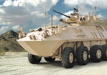
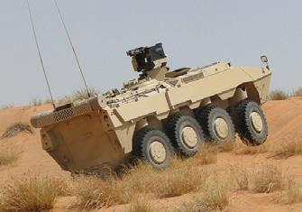
2 KVH Industries A Proven Systems Provider KVH Industries is a leading supplier of tactical navigation systems for use on armored vehicles. Based in Rhode Island, USA, KVH has been providing military navigation solutions since Since then, more than 18,000 KVH navigation and pointing systems have been fielded aboard combat, command, and support vehicles around the globe. KVH is an ISO 9001-registered company. The KVH TACNAV product family is designed with the modern battlefield in mind. The result is TACNAV s built-in capability to interface with virtually any digital Battlefield Management System. TACNAV Field-tested, Battle-proven The World s Premier Fighting s are Equipped with TACNAV, the Most Widely Fielded Navigation System in the World For over 20 years, KVH has worked closely with its military customers, creating digital navigation systems to meet the most demanding military requirements. TACNAV is the most widely fielded tactical navigation system in the world; field-tested and battle-proven under the most challenging of conditions.

3 TACNAV Tactical Navigation System Why You Need It The KVH TACNAV family is a versatile, modular, commercial off-theshelf solution that can be affordably fielded to improve the operational efficiency of combat and combat support vehicles. It provides an essential back-up navigation capability in GNSS-denied environments. Premier vehicles worldwide are equipped with TACNAV, making it the most widely fielded tactical navigation system. TACNAV offers benefits critical to battlefield success: Enhances the ability to deploy forces anywhere in the world at a moment s notice by providing vehicle crews and commanders with superior battlefield awareness, including steer-to displays for drivers and position displays for commanders. Easy to use and understand, thereby helping to prevent combat and combat support forces from getting lost, keeping them out of harm s way, and reducing the chances of fratricide. Complements GNSS by seamlessly filling in when GNSS is blocked or jammed. TACNAV is available in four variants to meet the requirements and budget of all types of combat and support vehicles. Capability TACNAV 3D TACNAV II TACNAV TLS TACNAV Light Dead Reckoning 0.2% distance travelled for 3 hours continuous travel 1% distance travelled for 2 hours continuous travel 2-3% distance travelled 2-3% distance travelled Pitch and Roll Accuracy 0.05 w/ GNSS (dynamic) 0.20 w/o GNSS (dynamic) 1.0 (static) up to ±45 3 up to 15 (static) 3 up to 15 (static) No No BMS/Optional UMD BMS/Optional UMD Far Target Location No No Turret Orientation, via BMS, via CANbus Ethernet, CANbus, RS-422 RS-422 Ethernet, CANbus, RS-422, RS-485 Ethernet, CANbus, RS-422, RS-485 Heading Accuracy BMS Interface Steer-to Display Interfaces


4 TACNAV 3D Three-axis Fiber Optic Inertial Navigation System with Embedded GPS/GNSS Compact full three-dimensional navigation 100% situational awareness with or without GNSS availability Heading accuracy within 0.05 Dead reckoning accuracy within 0.2% distance travelled Modular design for expandability Embedded GNSS Multiple interfaces for ease of integration Ethernet connectivity, including VICTORY protocols CANbus Integrates with a variety of military GPS systems Embedded GNSS Antenna Ethernet/BMS External DAGR CANbus J1939 Built-in two-way Iridium satellite communications for messaging and secure position reporting Note: indicates optional or customer-supplied components. Iridium Satcom Antenna Odometer TAE/Serial (RS-422 Rx) BMS Serial (RS-422 Tx/Rx) CANbus J1939 Additional options Ethernet LRF/Serial (RS-422 Rx)/RS-485


5 TACNAV II Fiber Optic Gyro Navigation Engine for the Digital Battlefield 100% situational awareness with or without GPS availability Heading accuracy within 0.5 Dead reckoning accuracy within 1% of distance travelled Most affordable gyro-based navigation system in the industry Compact, lightweight design (4 kg (8.8 lbs)) for easy installation Easy integration with Battlefield Management System (BMS) platforms Odometer Speed Sensor 28VDC Integrates with a variety of military GPS systems GPS Rockwell PLGR/DAGR Polaris RS-422 Tx/Rx BMS Sensor Antenna Magnetic Sensor Navigation Interface Data RS-422 Tx/Rx and Note: indicates optional or customer-supplied components.
 capable of presenting data in several languages Links")
 Crew Display Odometer Note: indicates optional or customer-supplied components.")
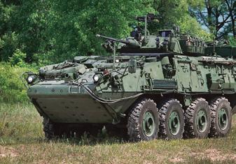
6 TACNAV TLS Digital Compass-based Target Location System for Turreted Armored s 100% situational awareness with or without GPS availability Heading accuracy within 2-3 Dead reckoning and odometer interface for accuracy to within 2-3% of distance travelled Compass-referenced Steer-to Navigation Display; Universal Multilingual Display (UMD) capable of presenting data in several languages Links with laser rangefinder to provide 150 meter CEP far target location at 5 km distance GPS Rockwell PLGR/DAGR MicroDAGR-V Polaris Auxiliary Turret Angle Encoder Box (TANGO II) Laser Rangefinder Turret Angle Encoder Integrates with a variety of military GPS systems Commander s Display Slip Ring Driver s Control Box (DCB) Crew Display Odometer Note: indicates optional or customer-supplied components. Sensor Antenna Driver s Display


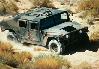
7 TACNAV Light Low-cost, Digital Compass-based Precision Solution for Light Navigation 100% situational awareness with or without GPS availability Heading accuracy within 2-3 Integrated odometer/compass dead reckon backup to GPS with an accuracy of 2-3% of distance travelled System ensures the highest degree of accuracy and unjammable position and navigation information Driver s Control Box (DCB) Universal Multilingual Display (UMD) capable of presenting data in multiple languages Ideal for all types of non-turreted vehicles, especially the infantry carrier, command and control, scout, HMMWV, and ambulance fleets Integrates with a variety of military GPS systems Driver s Display Odometer GPS Rockwell PLGR/DAGR Sensor MicroDAGR-V Antenna Polaris Note: indicates optional or customer-supplied components. Crew Display Commander s Display


8 OPTION: A Multipurpose Universal Multilingual Display (UMD) for Tactical Navigation The world s first multilingual display for tactical navigation systems Capable of displaying pop-up menus, configuration data, messages, and a variety of universally understood icons Generation III NVG-compatible Interchangeable Commander s and Driver s Displays reduce logistics cost Compatible with all existing and future KVH TACNAV systems BR_TACNAV_Family_12.14_gA4 Multiple UMDs capable of operating in two different languages from the same TACNAV system Made in the U.S.A. KVH Industries Pte Ltd. KVH Industries A/S KVH Industries, Inc. Asia-Pacific Headquarters EMEA Headquarters World Headquarters Singapore Kokkedal, Denmark Middletown, RI U.S.A. KVH45Industries, Inc. Enterprise Center Tel: Middletown, RI U.S.A. Phone: Fax: Tel: Fax: Tel: Fax: Fax: info@emea.kvh.com trademarks info@kvh.com , KVH Industries, Inc. KVH and TACNAV are registered of KVH Industries, Inc. Specifications subject to change info@apac.kvh.com without notice
ELECTRONICS & DEFENSE LAND INERTIAL NAVIGATION SYSTEMS
 ELECTRONICS & DEFENSE LAND INERTIAL NAVIGATION SYSTEMS Highly reliable navigation and precision strikes under any conditions HIGH PRECISION FOR SUCCESSFUL MISSIONS ALL YOUR MISSIONS require precision navigation
Maritime assault, patrol and insertion craft
 Maritime assault, patrol and insertion craft Rockwell Collins expertise in surface platforms also extends into the maritime domain. We offer a variety of products and systems that meet the needs of fast
Motion & Navigation Solution
 Navsight Land & Air Solution Motion & Navigation Solution FOR SURVEYING APPLICATIONS Motion, Navigation, and Geo-referencing NAVSIGHT LAND/AIR SOLUTION is a full high performance inertial navigation solution
PROTECTING GPS/GNSS-RELIANT MILITARY SYSTEMS
 PROTECTING GPS/GNSS-RELIANT MILITARY SYSTEMS John Fischer VP Advanced R&D Jon Sinden Product Manager, Rugged PNT 6/21/2018 ABOUT OROLIA A world leader in assured positioning, navigation and timing (PNT)
TECHNICAL PAPER: Performance Analysis of Next-Generation GNSS/INS System from KVH and NovAtel
 TECHNICAL PAPER: Performance Analysis of Next-Generation GNSS/INS System from KVH and NovAtel KVH Industries, Inc. 50 Enterprise Center Middletown, RI 02842 USA KVH Contact Information Phone: +1 401-847-3327
HALS-H1 Ground Surveillance & Targeting Helicopter
 ARATOS-SWISS Homeland Security AG & SMA PROGRESS, LLC HALS-H1 Ground Surveillance & Targeting Helicopter Defense, Emergency, Homeland Security (Border Patrol, Pipeline Monitoring)... Automatic detection
NovAtel SPAN and Waypoint. GNSS + INS Technology
 NovAtel SPAN and Waypoint GNSS + INS Technology SPAN Technology SPAN provides continual 3D positioning, velocity and attitude determination anywhere satellite reception may be compromised. SPAN uses NovAtel
Inertial Sensors. Ellipse Series MINIATURE HIGH PERFORMANCE. Navigation, Motion & Heave Sensing IMU AHRS MRU INS VG
 Ellipse Series MINIATURE HIGH PERFORMANCE Inertial Sensors IMU AHRS MRU INS VG ITAR Free 0.2 RMS Navigation, Motion & Heave Sensing ELLIPSE SERIES sets up new standard for miniature and cost-effective
ATLANS-C. mobile mapping position and orientation solution
 mobile mapping position and orientation solution mobile mapping position and orientation solution THE SMALLEST ATLANS-C is a high performance all-in-one position and orientation solution for both land
SENLUTION Miniature Angular & Heading Reference System The World s Smallest Mini-AHRS
 SENLUTION Miniature Angular & Heading Reference System The World s Smallest Mini-AHRS MotionCore, the smallest size AHRS in the world, is an ultra-small form factor, highly accurate inertia system based
HIGH-ACCURACY GYROCOMPASS
 HIGH-ACCURACY GYROCOMPASS and INERTIAL NAVIGATION PRODUCTS NAVAL NAVIGATION LAND NAVIGATION & POINTING AIR NAVIGATION COMMERCIAL & INDUSTRIAL GEM elettronica is a leading European supplier in the design,
Inertial Systems. Ekinox Series TACTICAL GRADE MEMS. Motion Sensing & Navigation IMU AHRS MRU INS VG
 Ekinox Series TACTICAL GRADE MEMS Inertial Systems IMU AHRS MRU INS VG ITAR Free 0.05 RMS Motion Sensing & Navigation AEROSPACE GROUND MARINE EKINOX SERIES R&D specialists usually compromise between high
SPAN Tightly Coupled GNSS+INS Technology Performance for Exceptional 3D, Continuous Position, Velocity & Attitude
 SPAN Tightly Coupled GNSSINS Technology Performance for Exceptional 3D, Continuous Position, Velocity & Attitude SPAN Technology NOVATEL S SPAN TECHNOLOGY PROVIDES CONTINUOUS 3D POSITIONING, VELOCITY AND
NAVIGAT Fiber-Optic Gyrocompass and Attitude Reference System. Sperry Marine. The Dynamic Solution for a Demanding Challenge
 NAVIGAT 2100 Fiber-Optic Gyrocompass and Attitude Reference System Sperry Marine The Dynamic Solution for a Demanding Challenge NAVIGAT 2100 Fiber-Optic Gyrocompass and Attitude Fiber-Optic Sensor Unit
KVH mini-vsat Broadband Redefining Satellite Communications at Sea
 KVH mini-vsat Broadband Redefining Satellite Communications at Sea Advancements in Satellite Communications at Sea Presented by Vivian Quenet Vice President of Sales Asia-Pacific KVH Industries Pte Ltd.
CODEVINTEC. Miniature and accurate IMU, AHRS, INS/GNSS Attitude and Heading Reference Systems
 45 27 39.384 N 9 07 30.145 E Miniature and accurate IMU, AHRS, INS/GNSS Attitude and Heading Reference Systems Aerospace Land/Automotive Marine Subsea Miniature inertial sensors 0.1 Ellipse Series New
GPS-Aided INS Datasheet Rev. 3.0
 1 GPS-Aided INS The Inertial Labs Single and Dual Antenna GPS-Aided Inertial Navigation System INS is new generation of fully-integrated, combined GPS, GLONASS, GALILEO, QZSS, BEIDOU and L-Band navigation
SERIES VECTORNAV TACTICAL SERIES VN-110 IMU/AHRS VN-210 GNSS/INS VN-310 DUAL GNSS/INS
 TACTICAL VECTORNAV SERIES TACTICAL SERIES VN110 IMU/AHRS VN210 GNSS/INS VN310 DUAL GNSS/INS VectorNav introduces the Tactical Series, a nextgeneration, MEMS inertial navigation platform that features highperformance
GPS-Aided INS Datasheet Rev. 2.7
 1 The Inertial Labs Single and Dual Antenna GPS-Aided Inertial Navigation System INS is new generation of fully-integrated, combined GPS, GLONASS, GALILEO, QZSS and BEIDOU navigation and highperformance
NovAtel SPAN and Waypoint GNSS + INS Technology
 NovAtel SPAN and Waypoint GNSS + INS Technology SPAN Technology SPAN provides real-time positioning and attitude determination where traditional GNSS receivers have difficulties; in urban canyons or heavily
Inertial Navigation System
 Apogee Marine Series ULTIMATE ACCURACY MEMS Inertial Navigation System INS MRU AHRS ITAR Free 0.005 RMS Navigation, Motion & Heave Sensing APOGEE SERIES makes high accuracy affordable for all surveying
GPS-Aided INS Datasheet Rev. 2.6
 GPS-Aided INS 1 GPS-Aided INS The Inertial Labs Single and Dual Antenna GPS-Aided Inertial Navigation System INS is new generation of fully-integrated, combined GPS, GLONASS, GALILEO and BEIDOU navigation
MARINS Series. Very high performance inertial navigation system
 MARINS Series Very high performance inertial navigation system MARINS M-Series Very high-performance inertial navigation system MARINS M-Series is a family of state-of-the-art naval inertial navigation
FULL MISSION REHEARSAL & SIMULATION SOLUTIONS
 FULL MISSION REHEARSAL & SIMULATION SOLUTIONS COMPLEX & CHANGING MISSIONS. REDUCED TRAINING BUDGETS. BECAUSE YOU OPERATE IN A NETWORK-CENTRIC ENVIRONMENT YOU SHOULD BE TRAINED IN ONE. And like your missions,
LT Iridium Communications System
 LT-3100 Iridium Communications System 1 Headlines Company Introduction LT-3100 Iridium Communications System What s in the box Iridium Coverage Navigational Products 2 Company Introduction Lars Thrane
Inertial Sensors. Ellipse Series MINIATURE HIGH PERFORMANCE. Navigation, Motion & Heave Sensing IMU AHRS MRU INS VG
 Ellipse Series MINIATURE HIGH PERFORMANCE Inertial Sensors IMU AHRS MRU INS VG ITAR Free 0.1 RMS Navigation, Motion & Heave Sensing ELLIPSE SERIES sets up new standard for miniature and cost-effective
Inertial Sensors. Ellipse 2 Series MINIATURE HIGH PERFORMANCE. Navigation, Motion & Heave Sensing IMU AHRS MRU INS VG
 Ellipse 2 Series MINIATURE HIGH PERFORMANCE Inertial Sensors IMU AHRS MRU INS VG ITAR Free 0.1 RMS Navigation, Motion & Heave Sensing ELLIPSE SERIES sets up new standard for miniature and cost-effective
Inertial Systems. Ekinox 2 Series TACTICAL GRADE MEMS. Motion Sensing & Navigation IMU AHRS MRU INS VG
 Ekinox 2 Series TACTICAL GRADE MEMS Inertial Systems IMU AHRS MRU INS VG ITAR Free 0.02 RMS Motion Sensing & Navigation AEROSPACE GROUND MARINE EKINOX 2 SERIES R&D specialists usually compromise between
Global Navigation Satellite System for IE 5000
 Global Navigation Satellite System for IE 5000 Configuring GNSS 2 Information About GNSS 2 Guidelines and Limitations 4 Default Settings 4 Configuring GNSS 5 Configuring GNSS as Time Source for PTP 6 Verifying
Inertial Navigation System
 Apogee Series ULTIMATE ACCURACY MEMS Inertial Navigation System INS MRU AHRS ITAR Free 0.005 RMS Motion Sensing & Georeferencing APOGEE SERIES makes high accuracy affordable for all surveying companies.
High Gain Advanced GPS Receiver
 High Gain Advanced GPS Receiver NAVSYS Corporation 14960 Woodcarver Road, Colorado Springs, CO 80921 Introduction The NAVSYS High Gain Advanced GPS Receiver (HAGR) is a digital beam steering receiver designed
Integrating SAASM GPS and Inertial Navigation: What to Know
 Integrating SAASM GPS and Inertial Navigation: What to Know At any moment, a mission could be threatened with potentially severe consequences because of jamming and spoofing aimed at global navigation
VPS-X Gyro-150 SNG DVB-S2 SD/HD SNG
 VPS-X Gyro-150 SNG DVB-S2 SD/HD SNG Redefining User Friendliness, Speed, Precision and Reliability. The VPS-X is the first vehicle mounted SNG system that has redundant pointing technology and does not
xoem500 Hardware Integration Manual Inertial and GNSS measurement system Confidently. Accurately.
 xoem500 xf Inertial and GNSS measurement system Hardware Integration Manual Confidently. Accurately. Table of contents Introduction 5 Related documents 6 Precautions 7 Compliance testing 7 Hardware description
Cooperative navigation: outline
 Positioning and Navigation in GPS-challenged Environments: Cooperative Navigation Concept Dorota A Grejner-Brzezinska, Charles K Toth, Jong-Ki Lee and Xiankun Wang Satellite Positioning and Inertial Navigation
SLX-1 Multi-Application GNSS Receiver
 SLX-1 Multi-Application GNSS Receiver w w w.sa tla b g p s. c o m SLX-1 Multi-Application GNSS Receiver Designed for CORS Ready for Anything European Standards GPS GLONASS BEIDOU GALILEO SBAS QZSS Long
IRIS PRODUCT LINE AND DATA INFORMATION
 PRODUCT LINE AND DATA INFORMATION IRIS I I I I I I I I I I I I I I I I I I I I I I I I I I I I I I I I I I I I I I I I I I I I I I I I I I I I I I I I I I I I I I I I I I I I I I I I I I I I I I I I I
FLIGHT DATA MONITORING
 FLIGHT DATA MONITORING RECORD REPLAY REVIEW FLIGHT DATA MONITORING FLIGHT TRAINING INCIDENT INVESTIGATION APPAREO S TURN-KEY FLIGHT DATA MONITORING SUITE When it comes to flight safety, there s nothing
GPS Application. Global Positioning System. We provide GPS module ODM / OEM service, any GPS receiver you want, we can provide customized services.
 GPS Application Global Positioning System We provide GPS module ODM / OEM service, any GPS receiver you want, we can provide customized services. www.win-tec.com.tw sales@win-tec.com.tw GNSS Receiver WGM-303
WATER CONSERVATION AND LANDFORMING
 WATER CONSERVATION AND LANDFORMING 2 LANDFORMING INDUSTRY LEADING LANDFORMING Proven survey, field design and landforming with GNSS accuracy. Topcon offers dual-constellation (GPS + GLONASS) satellite
Mission Solution 100
 Mission Solution 100 Standard configuration for littoral security Member of the Thales Mission Solution family Standard configuration of integrated sensors, effectors, CMS, communication system and navigation
TACOT Project. Trusted multi Application receiver for Trucks. Bordeaux, 4 June 2014
 TACOT Project Trusted multi Application receiver for Trucks Bordeaux, 4 June 2014 Agenda TACOT Context & Solution Technical developments Test & Validation results Conclusions GNSS ease our lives GNSS is
CENG 5931 HW 5 Mobile Robotics Due March 5. Sensors for Mobile Robots
 CENG 5931 HW 5 Mobile Robotics Due March 5 Sensors for Mobile Robots Dr. T. L. Harman: 281 283-3774 Office D104 For reports: Read HomeworkEssayRequirements on the web site and follow instructions which
Hyperion NEO-M8N GPS
 Hyperion M8N GPS Product description The M8 series of concurrent GNSS modules is built on the high performing M8 GNSS engine in the industry proven NEO form factor. The M8 modules utilize concurrent reception
Multimode Fiber Characterization Encircled Flux & Launch Condition Considerations
 Application Note Multimode Fiber Characterization Encircled Flux & Launch Condition Considerations Introduction Current communication data rates in local networks range from 10/100 Mbps for Ethernet to
RUDOLF Digital power analyzer. Advanced Version
 RUDOLF Digital power analyzer Advanced Version Digital power analyzer Advanced Version Company Introduction Bridex Singapore Pte Ltd is founded in 1978 as a manufacturer of instruments transformer for
Meridian Gyrocompasses
 TELEDYNE TSS WORLD LEADERS IN MARINE INSTRUMENTATION Meridian Gyrocompasses MARINE NAVIGATION SYSTEMS Highly accurate performance with low cost of ownership. The Meridian gyrocompass product range is suitable
360 compass card and digital display Performance Settle point error 0.25 secant latitude 0.10 secant latitude
 Meridian GYROCOMPASSES TECHNICAL SPECIFICATIONS Display Standard 360 compass card and digital display Surveyor Performance Settle point error 0.25 secant latitude 0.10 secant latitude Settle point repeatability
TACTICAL SERIES VECTORNAV INDUSTRIAL SERIES. Key Benefits Miniaturized surface mount & Rugged packaging. < 30 grams. Embedded Navigation Solutions
 TACTICAL SERIES VECTORNAV INDUSTRIAL SERIES VN100 IMU/AH AHRS VN200 GPS/INS VN300 DUAL GNSS/INS Key Benefits Miniaturized surface mount & Rugged packaging < 30 grams Embedded Navigation Solutions THE INDUSTRIAL
Leica GRX1200+ Series High Performance GNSS Reference Receivers
 Leica GRX1200+ Series High Performance GNSS Reference Receivers Leica GRX1200+ Series For permanent reference stations The Leica GRX1200+ Series, part of Leica's future proof System 1200, is designed specifically
INDUSTRIAL SCANNERS AND SYSTEMS
 INDUSTRIAL SCANNERS AND SYSTEMS Metrologic Instruments, Inc. is a global supplier of choice for data capture and collection hardware, optical solutions, and image processing software. Metrologic has been
Motion Reference Units
 Motion Reference Units MRU Datasheet Rev. 1.3 IP-67 sealed 5% / 5 cm Heave accuracy 0.03 m/sec Velocity accuracy 0.05 deg Pitch and Roll accuracy 0.005 m/sec2 Acceleration accuracy 0.0002 deg/sec Angular
TRINITY Standard configuration for littoral defence
 Standard configuration for littoral defence Member of the Thales Mission Solution family Unrivalled tracking and fire control solution for small manoeuvring targets Innovative approach and easy to install
ADMA. Automotive Dynamic Motion Analyzer with 1000 Hz. ADMA Applications. State of the art: ADMA GPS/Inertial System for vehicle dynamics testing
 ADMA Automotive Dynamic Motion Analyzer with 1000 Hz State of the art: ADMA GPS/Inertial System for vehicle dynamics testing ADMA Applications The strap-down technology ensures that the ADMA is stable
Mission Solution 300
 Mission Solution 300 Standard configuration for point defence Member of the Thales Mission Solution family Standard configuration of integrated sensors, effectors, CMS, communication system and navigation
INTELLIGENT LAND VEHICLE NAVIGATION: INTEGRATING SPATIAL INFORMATION INTO THE NAVIGATION SOLUTION
 INTELLIGENT LAND VEHICLE NAVIGATION: INTEGRATING SPATIAL INFORMATION INTO THE NAVIGATION SOLUTION Stephen Scott-Young (sscott@ecr.mu.oz.au) Dr Allison Kealy (akealy@unimelb.edu.au) Dr Philip Collier (p.collier@unimelb.edu.au)
FLCS V2.1. AHRS, Autopilot, Gyro Stabilized Gimbals Control, Ground Control Station
 AHRS, Autopilot, Gyro Stabilized Gimbals Control, Ground Control Station The platform provides a high performance basis for electromechanical system control. Originally designed for autonomous aerial vehicle
Ground Jammers. ARIEL Photonics Assembly unclassified presentation CLOUD (TRL 8), CLOUDLET (TRL 7)
, CLOUDLET (TRL 7)") ARIEL Photonics Assembly unclassified presentation Ground Jammers 4 Hama ayan Street, Modi in, Israel 71700 Telephone: +972-8-971-7990, Fax: +972-8-971-7991 www.arielphotonicsinc.com yaniv@arielgroupinc.com
ARIEL Photonics Assembly unclassified presentation Ground Jammers 4 Hama ayan Street, Modi in, Israel 71700 Telephone: +972-8-971-7990, Fax: +972-8-971-7991 www.arielphotonicsinc.com yaniv@arielgroupinc.com
Principal Investigator Co-Principal Investigator Co-Principal Investigator Prof. Talat Ahmad Vice-Chancellor Jamia Millia Islamia Delhi
 Subject Paper No and Title Module No and Title Module Tag Geology Remote Sensing and GIS Concepts of Global Navigation Satellite RS & GIS XXXIII Principal Investigator Co-Principal Investigator Co-Principal
LE18, LE20, LE25 Incremental Linear Encoders
 and LE30 LE18, LE20, LE25 Incremental Linear Encoders Motion Type: Linear Usage Grade: Industrial Output: Incremental Max Resolution: 0.1 to 10 m High Resolution - Industrial Ruggedness The Models LE18,
ASC Signal Capabilities
 ASC Signal Capabilities Prepared by ASC Product & Support Group May 24 th, 2013 About the Company About ASC Formerly Andrew Satellite Communications, ASC Signal is a leading manufacturer of earth station
Defeating Magnetic Interference on the Battlefield
 Defeating Magnetic Interference on the Battlefield How multiple sensory inputs are enabling lightweight robust weapon pointing for mortar fire control systems Presented by Michael Wright & Ralph Tillinghast
Tactical Radio Products. U.S. Government Products. The most comprehensive. family of tactical radios, available today. FALCON II
 Tactical Radio Products U.S. Government Products The most comprehensive family of tactical radios, available today. FALCON II Outperforming the Competition. The FALCON II software-defined radios provide
GPS-Aided INS Datasheet Rev. 2.3
 GPS-Aided INS 1 The Inertial Labs Single and Dual Antenna GPS-Aided Inertial Navigation System INS is new generation of fully-integrated, combined L1 & L2 GPS, GLONASS, GALILEO and BEIDOU navigation and
Cobham SATCOM Marine. Chris Insall Manager, Commercial Programmes. Hamburg, 28 th Feb Digital Ship Hamburg - 28 February 2013
 Digital Ship Hamburg - 28 February 2013 The most important thing we build is trust AEROSPACE AND SECURITY DIVISION Aerospace Communications Antenna Systems Commercial Systems SATCOM Tactical Communications
Electronic Compass Sensors Rev. 1.1 Jan. 2002
 Electronic Compass Sensors Rev. 1.1 Jan. 2002 TCM2 Series TCM2-20 TCM2-50 TCM2-80 TCMVR Series TCMVR-20 TCMVR-50 V2X Series V2X V2XG registered trademarks of Precision Navigation Inc. TCM 2 Series The
Engtek SubSea Systems
 Engtek SubSea Systems A Division of Engtek Manoeuvra Systems Pte Ltd SubSea Propulsion Technology AUV Propulsion and Maneuvering Modules Engtek SubSea Systems A Division of Engtek Manoeuvra Systems Pte
Lars Thrane A/S. September 19, LT-1000 NRU & LT-500 AHRS Installation on Grand Banks 64 Aleutian
 Lars Thrane A/S September 19, 2016 LT-1000 NRU & LT-500 AHRS Installation on Grand Banks 64 Aleutian LT-1000 NRU Key Features Navigation Reference Unit with 12 precision sensors True heading, magnetic
Recent Advances in Low SWaP for Position, Navigation and Timing and Frequency Sources for Military Communication Systems
 Recent Advances in Low SWaP for Position, Navigation and Timing and Frequency Sources for Military Communication Systems Lisa Perdue, Spectracom Spectracom: Essential Ingenuity Spectracom simplifies the
USBL positioning and communication SyStEmS. product information GUidE
 USBL positioning and communication SyStEmS product information GUidE evologics s2c R usbl - series underwater positioning and communication systems EvoLogics S2CR USBL is a series of combined positioning
KCS TraceME TM-203 / R9F4 GPS / GPRS / SMS / RFID module, OEM Version
 KCS TraceME TM-203 / R9F4 GPS / GPRS / SMS / RFID module, OEM Version The KCS GPRS/GPS range of modules enables you to remotely track & trace people, animals and a variety of objects, e.g. cars, trucks,
Leveraging Technology to Deliver Best Value
 HF Communications Leveraging Technology to Deliver Best Value Business Balance Rockwell Collins is a leader in the design, production and support of communications, aviation, integrated systems and platform
IMU60 Inertial Measurement Unit
 Precision 6 DoF MEMS Inertial Measurement Unit Range: acc ±2g, gyro ±300 /s, (ODM supported) Acc Bias Instability: ±70mg, Gyro Bias Instability: 24 /h Data Update Rate: 100Hz Wide Input Power Range: 5~18VDC
LBL POSITIONING AND COMMUNICATION SYSTEMS PRODUCT INFORMATION GUIDE
 LBL POSITIONING AND COMMUNICATION SYSTEMS PRODUCT INFORMATION GUIDE EvoLogics S2C LBL Underwater Positioning and Communication Systems EvoLogics LBL systems bring the benefi ts of long baseline (LBL) acoustic
LAND DEFENSE & SECURITY LAND DEFENSE & SECURITY 1
 LAND DEFENSE & SECURITY LAND DEFENSE & SECURITY 1 LAND DEFENSE AND SECURITY 2 LAND DEFENSE & SECURITY LAND DEFENSE & SECURITY 3 INERTIAL NAVIGATION 8 Challenges and solutions 10 Products range 16 Applications
High Performance Advanced MEMS Industrial & Tactical Grade Inertial Measurement Units
 High Performance Advanced MEMS Industrial & Tactical Grade Inertial Measurement Units ITAR-free Small size, low weight, low cost 1 deg/hr Gyro Bias in-run stability Datasheet Rev.2.0 5 μg Accelerometers
The FEI-Zyfer Family of Modular, GPS-Aided Time & Frequency Systems
 The FEI-Zyfer Family of Modular, GPS-Aided Time & Systems Multiple Capabilities Easily Configured High Performance Flexible, Expandable, Upgradable Redundant & Reliable Hot- Swappable Easily Maintainable
Mission Critical DAS Solution
 Mission Critical DAS Solution In-Building Cellular Satellite Phone Coverage Mission Critical DAS solution for In-Building Systems provides a simple, low-cost, limitless bandwidth method to distribute multi-channel,
Crawler Tractors PR 714 PR 764. Product information. Grade control systems
 Crawler Tractors PR 714 PR 764 Product information Grade control systems Grade Control Systems for Crawler Tractors To be successful in spite of ever-increasing time and cost pressures, construction machinery
F-104 Electronic Systems
 Information regarding the Lockheed F-104 Starfighter F-104 Electronic Systems An article published in the Zipper Magazine # 49 March-2002 Author: Country: Website: Email: Theo N.M.M. Stoelinga The Netherlands
BE HEARD ON THE FRONT LINE
 BE HEARD ON THE FRONT LINE DEFENCE SOLUTIONS Unable To Talk Across Comms Devices Tactical operations require the flexibility for troops to communicate from remote locations, while on foot and in vehicles.
Light section sensors LPS / LES / LRS The better and cheaper solution for many new areas of application
 Light section sensors LPS / LES / LRS The better and cheaper solution for many new areas of application PRODUCT INFORMATION Reliable object detection no longer needs to be a matter of price. Our new light
Leica GRX1200 Series High Performance GNSS Reference Receivers
 Leica GRX1200 Series High Performance GNSS Reference Receivers Leica GRX1200 Series For permanent reference stations The Leica GRX1200 Series, part of Leica s new System 1200, is designed specifically
SDR D Ultra High Sensitivity Ublox 6 GPS module Super Dead Reckoning GPS Module with Gyro on Board Detect Speed by Can Bus
 SDR 4130 3D Ultra High Sensitivity Ublox 6 GPS module Super Dead Reckoning GPS Module with Gyro on Board Detect Speed by Can Bus Smart Design Technology Co., Ltd. 20F-8, No.107, Sec 1,Jhongshan Rd. Sinjhuang
CATEGORY 7 - NAVIGATION AND AVIONICS A. SYSTEMS, EQUIPMENT AND COMPONENTS
 Commerce Control List Supplement No. 1 to Part 774 Category 7 page 1 CATEGORY 7 - NAVIGATION AND AVIONICS A. SYSTEMS, EQUIPMENT AND COMPONENTS N.B.1: For automatic pilots for underwater vehicles, see Category
Keywords. DECCA, OMEGA, VOR, INS, Integrated systems
 Keywords. DECCA, OMEGA, VOR, INS, Integrated systems 7.4 DECCA Decca is also a position-fixing hyperbolic navigation system which uses continuous waves and phase measurements to determine hyperbolic lines-of
IQS-2100/FLS-2100 OPTICAL LIGHT SOURCE. Telecom Test and Measurement
 OPTICAL LIGHT SOURCE R&D AND MANUFACTURING OPTICAL Single- or dual-wavelength LED or Fabry-Perot laser 10 db variable output power Excellent stability Available in benchtop (FLS) or modular (IQS) format
Next Generation Light/Medium Main Battle Tank Upgrade Solutions.
 Next Generation Light/Medium Main Battle Tank Upgrade Solutions www.aselsan.com.tr NEXT GENERATION LIGHT/MEDIUM MAIN BATTLE TANK UPGRADE SOLUTIONS ASELSAN presents her unrivalled Next Generation Light/Medium
Moving Towards a Standardized Interface for Acoustic Inertial Reference Systems
 Author s Name Name of the Paper Session DYNAMIC POSITIONING CONFERENCE October 14-15, 2014 SENSORS SESSION Moving Towards a Standardized Interface for Acoustic Inertial Reference Systems By Mark Carter
S a t e l l i t e T i m e a n d L o c a t i o n. N o v e m b e r John Fischer VP Advanced R&D
 STL - S a t e l l i t e T i m e a n d L o c a t i o n N o v e m b e r 2 0 1 7 John Fischer VP Advanced R&D jfischer@orolia.com 11/28/201 1 7 WHY AUGMENT GNSS? Recent UK Study Economic Input to UK of a
AVIATOR 300. Single Channel SwiftBroadband with Intermediate Gain Antenna Data Sheet. The most important thing we build is trust
 AVIATOR 300 Single Channel SwiftBroadband with Intermediate Gain Antenna 2013 Data Sheet The most important thing we build is trust Satcom for aircraft of any size and application Connect your tablet or
TRANSPORTATION COMMUNICATION SOLUTIONS
 INNOVATIVE COMMUNICATION SOLUTIONS TRANSPORTATION COMMUNICATION SOLUTIONS TM A Division Of A DIVISI O N O F NOR S AT I N T E R N AT I ON A L I N C. THE SINCLAIR STANDARD Sinclair Technologies is Norsat
ENAiKOON inmarsat-600
 -600 Inmarsat modem for worldwide satellite communication -600 enables communication between trackables and the back-end system through satellite communication. -600 was designed specifically for fleet
MG100 Single Axis MEMS Gyro
 Cost Effective Z Axis MEMS Gyro Heading: diverging 0.1 /hour Range: gyro ±300 /s, (ODM supported) Wide Input Power Range: 6~14VDC Compact and Lightweight - 50 x 45 x 21 (mm), 70g Wide Working Temperature:
NETNode IP Mesh Overview. Audio and Video Products Cobham Tactical Communications & Surveillance
 NETNode IP Mesh Overview Audio and Video Products Cobham Tactical Communications & Surveillance NETNode IP MESH Radio NETNode IP Mesh Radio: The Performance of COFDM with the Flexibility of IP Enhanced
Supporting the Warfighter from Space
 Dr. Michael Zatman Program Manager, Special Projects Office Space Activities Supporting the Warfighter from Space Why is space so important to our future capabilities? To appreciate this, we should review
Leadership built upon facts Cobham SATCOM Maritime communication solutions
 Friday, 10 April 2015 The most important thing we build is trust MARINE FleetBroadband VSAT solutions Satellite TV GMDSS VHF and MF/HF radios AIS, Navtex LAND BGAN Portable and Vehicular terminals VSAT
LEADING THE WAY FROM SEA TO LAND SURVEILLANCE RADAR SOLUTIONS
 LEADING THE WAY FROM SEA TO LAND SURVEILLANCE RADAR SOLUTIONS SITUATIONAL INTELLIGENCE, THE WORLD OVER A Kelvin Hughes radar is the primary tool for long range threat detection. On land and at sea we provide