RIS in Germany. RIS week Berlin.
|
|
|
- Marjory Franklin
- 6 years ago
- Views:
Transcription

1 RIS in Germany RIS week 2014 Berlin

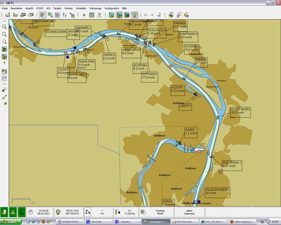
2 Main Waterways in Germany The German Waterway and Shipping Administration maintains 23,000 km² maritime waterways 7,300 km inland waterways 5,100 km main waterways (class IV or above) New waterway categories according to the amount of transport red - waterways priority A yellow - waterways priority B black waterways priority C blue other waterways green - priority current open 2
3 Current RIS-Applications Information Services NIF nautical information service via VHF-radio VTS Gorge section Information about traffic flow by special visual aids ELWIS Electronic Waterway Information Service (internet service) ELWIS-Abo Subscription for Information via SMS or Management Services On Board ARGO Advanced River Information (Inland ECDIS) AIS Automatic Identification System On Shore MOVES lock management service (Modern Traffic Data Collection System) MIB Information service for calamity abatement 3
4 RIS-Systems in use Visual and radar reflecting aids to navigation, light signals Mobile Phone (voice and data) VHF-radio Internet Vessel - based radar Shore - based radar (D)GPS for vessel positioning Electronic nautical charts Ship reporting system 4

5 ELWIS The German internet portal for inland navigation ELWIS access in 2013: 51,3 mio. visited the ELWIS homepage. 3,2 mio. s sent. 263 ELWIS-authors feed data into the system. At the moment, a route- and chart-based search function is being developed. 5


6 Implementing Inland AIS into the German RIS RIS Technologie Inland AIS Informationen Inland AIS Europa Anwendungen Standardisierung Zusammenfassung VBW Thementag 14. November 201 Duisburg


7 Precondition I - Vessel equipment Inland AIS connected to ENC (e.g. IECDIS) Leo Sympher L=20 m; B =7 m v=10,5 km/h Inland AIS station el. navigation chart IECDIS navigation mode 7
8 Precondition II - Standards and regulation VTT standard defines Inland AIS EU Directive 415/2007 (VTT standard) CCNR VTT standard and Inland AIS test standard UNECE Resolution 63 (VTT standard) Inland AIS shipborne mobile station Type approved Inland AIS stations Specialised firms for installation and testing Supporting program for Inland AIS equipment Operational and technical guidelines for the use of Inland AIS Mandatory Carriage requirement Existing requirements at Danube (AU, SL, HU), Antwerp, NOK Rhine from Dec 2014 (CCNR): Inland AIS and el. chart system other waterways are expected to follow 8
9 Establishment of the shore-based AIS infrastructure Inland AIS Inland AIS has been developed to support on - board navigation and shore - based RIS services in inland navigation Implementing Inland AIS Guidelines and Recommendation for River Information Services identify Inland AIS as the RIS key technology for the tracking and tracing of inland navigation vessels The German AIS network The German waterway and shipping agency is now in the process to expand their shore based AIS infrastructure towards the German main inland waterway network Use of Inland AIS in the German waterway network The aim is to support the work of RIS centers, lock management, ship reporting, etc. 9

10 Support of River Information Services by Inland AIS in Germany Set up to support the following services Traffic monitoring Information services Lock management Calamity abatement Waterway statistics Ship reporting Waterway charges Traffic Statistics 10

11 Technical implementation of the German Inland AIS shore infrastructure The Inland AIS network will cover about 2400 km of inland waterways. It consists of: 86 physical Inland AIS shore stations along the rivers and canals, 9 AIS Repeater Stations 4 Regional AIS servers. The Regional AIS Servers provide the Logical AIS shore station which is the functional interface with other RIS services, like VTS, lock operation, and provides those services with data for further processing. The German Inland AIS network shall be fully operational by mid


12 Inland AIS shore infrastructure in Germany - Roadmap Los1: 86 AIS Shore stations and 9 Repeater stations Los2: 4 Regional IAIS Server + 1 central technical evaluation Mid 2015 Full operational phase Initial operational phase Oct 2014 Mai 2014 Start of implementation Los1+ Los2 26.März 2014 Kick Off Los1 + Los2 12
13 Full AIS coverage of relevant inland waterways Use of existing VHF voice radio telephony infrastructure (NIF) antenna mast, shelter, energy supply, land line for data transfer 4 regional Inland AIS centers - Middle (Minden): Weser, MLK, ESK, - West (Duisburg): Rhine, Western Channels - South-West (Oberwesel): Rhine, Mosel, Saar - South (Gösseltalmühle): Main, MDK, Danube Central technical evaluation center 13 Inland AIS shore infrastructure


14 Set up Inland AIS shore station VHF Antenne VHF Reserveantenne Wird für AIS und NIF benutzt GPS Antenne GPS antenna Dokumentenfach VHF antenna Basisstation Anschlußdose RJ45 14 Abgesicherte 230 V Steckdose 230V USV 230V Powerswitch Switch USV 1200x800x800 AIS shore station Daten housing

15 AIS Repeater station to enable ship to ship data exchange in difficult radio propagation AIS VHF Repeater AIS VHF AIS VHF bottleneck AIS : ship - ship (data) VHF : ship - ship (voice) AIS Repeater ashore enable data exchange ship-ship also in case of difficult radio propagation. Extended Radio Coverage by re-transmission of the AIS VDL Messages received. Inland AIS for communication ship ship for navigation in bottlenecks ( Datenfunk-Selbstwahrschau )


16 Data provided by Inland AIS shore infrastructure 16


17 The regional AIS Server is the interface of the AIS service to other Services to transfer data: - received from vessels to connected RIS - from connected RIS services via Inland AIS shore stations to + all vessels in a region or + addressed to single vessels Service architecture Regional AIS server 17 Display for maintenance personnel

18 Lockmanagement 18


19 Why? ????
20 Basic Idea Vessels Restrictions Parameter Lock- management Traffic Journal Sequence Locks 20


21 Basic Idea Restrictions Locks Vessels Lockmanagement + - Suggestion for sequence Assessment 21
22 To Do Lock- management Optimization Traffic Journal AIS- Infrastructure 22

23 Optimization - Startposition 13 Vessels / 4 Locks Dense voyages Vessels and Locks can be configurated separately 23
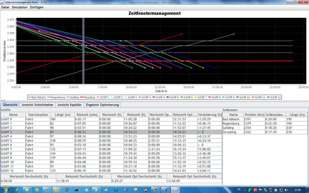
24 Optimization - solved 24
25 Current work Lock management project on the Danube AIS-Infrastructure will be available latest October 2014 Tender for Software is ready and will be made public in July 2014 Software will be tested end 2014/early 2015 Evaluation of Lockmanagement will be done starting April
26 Prospects for the future Obligation to install Inland AIS and Inland ECDIS on all German main waterways Equipping all vessels with Inland AIS and Inland ECDIS Use of Inland AIS in the VTS centres Information exchange in an international network Data management in connection with reference database We expect that Inland AIS will be used intensively to support and maintain the high standard on waterways in terms of safety and smooth operations as well as with Inland ECDIS The development, introduction and in order to satisfy changing demands - updating of information systems such as the ones described above can make a major contribution towards guaranteeing efficient and safe navigation on inland waterways, now and in the future. 26
27 Thank you for your attention! Federal Ministry of Transport and Digital Infrastructure Nils Braunroth Robert-Schuman-Platz 1 D Bonn
28 28
INVENTORY FOR HARMONISED INLAND AIS APPLICATION SPECIFIC MESSAGES IN EUROPE
 INVENTORY FOR HARMONISED INLAND AIS APPLICATION SPECIFIC MESSAGES IN EUROPE GUIDELINES OF THE VTT EXPERT GROUP Edition 1.2 Version: 12-07-2017 Author: Vessel Tracking and Tracing Expert Group TABLE OF
JOURNAL OF MARITIME RESEARCH. The Architecture of Data Transmission in Inland Navigation
 JOURNAL OF MARITIME RESEARCH Vol XI. No. II (2014) pp 3 7 ISSN: 1697-4040, www.jmr.unican.es The Architecture of Data Transmission in Inland Navigation A. Lisaj 1,2, and P. Majzner 3 ARTICLE INFO Article
INFORMATION PAPER ON AIS AIDS TO NAVIGATION REPORT MESSAGES IN INLAND WATERWAYS
 INFORMATION PAPER ON AIS AIDS TO NAVIGATION REPORT MESSAGES IN INLAND WATERWAYS Edition 1.1 Version: 09-05-2017 Author: Inland ECDIS Expert Group and Vessel Tracking and Tracing Expert Group VTT / IECDIS
DISC Ukrainian National Status Report
 DISC 2016 Ukrainian National Status Report NU OMA, prof.doct.tech Igor Gladkykh phone +380503909586 e-mail:gladkykh958@gmail.com Nick Golodov Hydrography Service of Ukraine phone +380444256874 e-mail:
The role of EGNOS in the recapitalised DGNSS service of WSV - concept and implementation
 The role of EGNOS in the recapitalised DGNSS service of WSV - concept and implementation Tamás Horváth 1, Michael Hoppe 2 1 Alberding GmbH 2 German Federal Waterways and Shipping Administration (WSV) EGNOS
RIVER INFORMATION SERVICES ON THE ODRA RIVER
 RIVER INFORMATION SERVICES ON THE ODRA RIVER PIOTR DURAJCZYK INLAND NAVIGATION OFFICE IN SZCZECIN NETWORK OF EUROPEAN WATERWAYS Źródło: K. Woś na podstawie European Agreement on Main Inland Waterways of
IENC production at the Flemish Hydrography. HYDRO12, 15 th November 2012 Jasmine Dumollin
 IENC production at the Flemish Hydrography HYDRO12, 15 th November 2012 Jasmine Dumollin ENC versus Inland ENC Definition Inland ENC Database, standardized as to content, structure and format, for use
ANNEX ANNEX. Accompanying the document. Commission Implementing Regulation
 Ref. Ares(2018)3546601-04/07/2018 EUROPEAN COMMISSION Brussels, XXX [ ](2018) XXX draft ANNEX ANNEX Accompanying the document Commission Implementing Regulation on technical specifications for vessel tracking
GUIDANCE FOR THE PRESENTATION AND DISPLAY OF AIS APPLICATION-SPECIFIC MESSAGES INFORMATION
 E 4 ALBERT EMBANKMENT LONDON SE1 7SR Telephone: +44 (0)20 7735 7611 Fax: +44 (0)20 7587 3210 Ref. T2-OSS/2.7.1 SN.1/Circ.290 2 June 2010 GUIDANCE FOR THE PRESENTATION AND DISPLAY OF AIS APPLICATION-SPECIFIC
COMMISSION IMPLEMENTING REGULATION (EU)
") 28.7.2012 Official Journal of the European Union L 202/5 REGULATIONS COMMISSION IMPLEMENTING REGULATION (EU) No 689/2012 of 27 July 2012 amending Regulation (EC) No 415/2007 concerning the technical specifications
28.7.2012 Official Journal of the European Union L 202/5 REGULATIONS COMMISSION IMPLEMENTING REGULATION (EU) No 689/2012 of 27 July 2012 amending Regulation (EC) No 415/2007 concerning the technical specifications
RESOLUTION MSC.278(85) (adopted on 1 December 2008) ADOPTION OF THE NEW MANDATORY SHIP REPORTING SYSTEM "OFF THE COAST OF PORTUGAL - COPREP"
 (adopted on 1 December 2008) ADOPTION OF THE NEW MANDATORY SHIP REPORTING SYSTEM OFF THE COAST OF PORTUGAL - COPREP") MSC 85/26/Add.1 RESOLUTION MSC.278(85) SYSTEM OFF THE COAST OF PORTUGAL COPREP THE MARITIME SAFETY COMMITTEE, RECALLING Article 28 of the Convention on the International Maritime Organization concerning
MSC 85/26/Add.1 RESOLUTION MSC.278(85) SYSTEM OFF THE COAST OF PORTUGAL COPREP THE MARITIME SAFETY COMMITTEE, RECALLING Article 28 of the Convention on the International Maritime Organization concerning
ETSI Workshop "Future Evolution of Marine Communication Radar evolution for inland waterways navigation Mario Walterfang
 Mario Walterfang Fachstelle der WSV für Verkehrstechniken (FVT) Federal German Waterways and Shipping Administration Sophia Antipolis, France, November 7th, 2017 Overview Milestones in river radar evolution
COMMUNICATIONS FOR MARITIME SAFETY AND EFFICIENCY. Francis Zachariae, Secretary-General, IALA
 COMMUNICATIONS FOR MARITIME SAFETY AND EFFICIENCY Francis Zachariae, Secretary-General, IALA IALA and its Purpose Non profit, international technical association established in 1957 Two Goals aimed at
How Automatic Identification System (AIS) Is Being Used to Improve Navigation Safety Lock Operations Management Application Michael Winkler
 Is Being Used to Improve Navigation Safety Lock Operations Management Application Michael Winkler") How Automatic Identification System (AIS) Is Being Used to Improve Navigation Safety Lock Operations Management Application Michael Winkler June 2016 LOMA system overview USCG AIS data capabilities: AIS
How Automatic Identification System (AIS) Is Being Used to Improve Navigation Safety Lock Operations Management Application Michael Winkler June 2016 LOMA system overview USCG AIS data capabilities: AIS
AIS 3410 Automatic Identification System
 Automatic Identification System General Unknown vessel on my starboard bow... radio communications like this are a commonplace occurrence for the officer on watch during night time, especially in coastal
Challenges and opportunities in the e-navigation Development. Actual projects.
 Challenges and opportunities in the e-navigation Development. Actual projects. John Erik Hagen, Regional Director Oslo, September 2018 What is e-navigation? Efficient transfer of marine information and
National Report of Finland
 National Report of Finland 1. Finnish Hydrographic Office The Finnish Hydrographic Office is organized under The Finnish Transport Agency. The Finnish Transport Agency is responsible for the Finnish roads,
E-NAVIGATION AND BEYOND
 E-NAVIGATION AND BEYOND The Work of IALA e-navigation Committee and Future CDR. Hideki NOGUCHI, Chair, IALA ENAV Committee e-navigation (ENAV) Committee Established in 2010 by merging R-NAV and AIS Committee
Automatic Identification System And Its Integration On The Great Lakes And St. Lawrence Seaway
 I Automatic Identification System And Its Integration On The Great Lakes And St. Lawrence Seaway Prepared by Melissa Hopkins - 20010575 Adam Howell - 20001016 David Ingram - 20001119 Andrew Wakeham - 20010422
Integration of AIS functionalities
 Integration of AIS functionalities by John O. Klepsvik FARGIS 05 March 01, 2005 WORLD CLASS through people, technology and dedication WORLD CLASS through people, technology and dedication KONGSBERG March
RF Monitoring Service Profile Based on AIS Binary Message
 , pp.55-59 http://dx.doi.org/10.14257/astl.2015.108.13 RF Monitoring Service Profile Based on AIS Binary Message Soyoung Hwang Catholic University of Pusan, 609-757 Busan, South Korea soyoung@cup.ac.kr
Expanded use of Automatic Identification System (AIS) navigation technology in Vessel Traffic Services (VTS) B. J. Tetreault 1
 navigation technology in Vessel Traffic Services (VTS) B. J. Tetreault 1") Expanded use of Automatic Identification System (AIS) navigation technology in Vessel Traffic Services (VTS) B. J. Tetreault 1 1 (At time of writing) U. S. Coast Guard, Office of Shore Forces (CG-7413),
Expanded use of Automatic Identification System (AIS) navigation technology in Vessel Traffic Services (VTS) B. J. Tetreault 1 1 (At time of writing) U. S. Coast Guard, Office of Shore Forces (CG-7413),
FOREWORD. IHO S-100 Working Group
 IHO International Hydrographic Organization KHOA Korea Hydrographic and Oceanographic Agency MUCH MORE THAN JUST NAUTICAL CHARTS IHO UNIVERSAL HYDROGRAPHIC data MODEL This document was produced with the
E-Navigation: Opening the door to the future
 International Association of Marine Aids to Navigation and Lighthouse Authorities E-Navigation: Opening the door to the future E-Navigation Underway North America November 2018 Secretary-General Francis
Automatic identification system VHF data link loading
 Report ITU-R M.2287-0 (12/2013) Automatic identification system VHF data link loading M Series Mobile, radiodetermination, amateur and related satellite services ii Rep. ITU-R M.2287-0 Foreword The role
INTERNATIONAL STANDARD
 INTERNATIONAL STANDARD IEC 62320-1 First edition 2007-02 Maritime navigation and radiocommunication equipment and systems Automatic identification system (AIS) Part 1: AIS Base Stations Minimum operational
FURUNO DEEPSEA WORLD Class-A Universal AIS Automatic Identification System. The future today with FURUNO's electronics technology.
 R FURUNO DEEPSEA WORLD Class-A Universal AIS Automatic Identification System Model FA-100 The AIS improves the safety of navigation by assisting in the efficient navigation of ships, protection of the
Annex III - 3. Memorandum of Understanding on the development of the Pan-European Transport Corridor VII (The Danube) (DRAFT)
 (DRAFT)") Annex III - 3 Memorandum of Understanding on the development of the Pan-European Transport Corridor VII (The Danube) (DRAFT) Desiring to promote international transport of goods and passengers through
Annex III - 3 Memorandum of Understanding on the development of the Pan-European Transport Corridor VII (The Danube) (DRAFT) Desiring to promote international transport of goods and passengers through
A Survey of Mariners' Opinions on Using Electronic Charts
 s i l s Note A Survey of Mariners' Opinions on Using Electronic Charts Igor Karnicnik, M.Sc., Geodetic Institute of Slovenia, Slovenia. A new component of modern shipborne navigation equipment is the Electronic
Maritime Geo-Fence Letter Report
 Report No. CG-D-10-16 Maritime Geo-Fence Letter Report Authors: Irene Gonin and Gregory Johnson Distribution Statement A: Approved for public release; distribution is unlimited. July 2016 Classification
L AGENCE NATIONALE DES FREQUENCES (ANFR) From Titanic to satellite from Morse to digital Entry in a new era for the maritime community
 From Titanic to satellite from Morse to digital Entry in a new era for the maritime community") L AGENCE NATIONALE DES FREQUENCES (ANFR) From Titanic to satellite from Morse to digital Entry in a new era for the maritime community ITU regional seminar 6-8 June 2018 St-Petersburg, Russian Federation
L AGENCE NATIONALE DES FREQUENCES (ANFR) From Titanic to satellite from Morse to digital Entry in a new era for the maritime community ITU regional seminar 6-8 June 2018 St-Petersburg, Russian Federation
Government Agency Perspectives & Initiatives Canadian Coast Guard Laurent Tardif, Director, Safe Shipping
 Unclassified Government Agency Perspectives & Initiatives Canadian Coast Guard Laurent Tardif, Director, Safe Shipping Mariner s Workshop January 23, 2019 1 Overview 1 Context 2 Marine Fees 3 4 5 Update
Demonstrator of a Data Processing Centre (DPC) for satellite-based AIS services
 for satellite-based AIS services") Page 1 Demonstrator of a Data Processing Centre (DPC) for satellite-based AIS services 19/20 April 2012 gfabritius@cls.fr Overview of the presentation Page 2 Introducing CLS Introducing AIS / SAT-AIS Scope
Page 1 Demonstrator of a Data Processing Centre (DPC) for satellite-based AIS services 19/20 April 2012 gfabritius@cls.fr Overview of the presentation Page 2 Introducing CLS Introducing AIS / SAT-AIS Scope
GUIDELINES ON THE DESIGN AND USE OF PORTABLE PILOT UNITS INTERNATIONAL MARITIME PILOTS ASSOCIATION
 GUIDELINES ON THE DESIGN AND USE OF PORTABLE PILOT UNITS INTERNATIONAL MARITIME PILOTS ASSOCIATION WITH TECHNICAL INPUT FROM Comité International Radio-Maritime (CIRM) 2 FOREWORD With the increasing use
GPS Jamming and its impact on maritime navigation
 GPS Jamming and its impact on maritime navigation Dr Alan Grant Research and Development - Special Interest Group 10 th May 2010 Use of GPS in the maritime sector GPS has become the normal means for maritime
The Role of Automatic Identification System (AIS) in Enhancing Vessel Traffic Management By Capt. Ehab Ibrahim Etman
 in Enhancing Vessel Traffic Management By Capt. Ehab Ibrahim Etman") The Role of Automatic Identification System (AIS) in Enhancing Vessel Traffic Management By Capt. Ehab Ibrahim Etman Abstract The International Maritime Organization (IMO) adopted a new requirement for
The Role of Automatic Identification System (AIS) in Enhancing Vessel Traffic Management By Capt. Ehab Ibrahim Etman Abstract The International Maritime Organization (IMO) adopted a new requirement for
Digital broadcasting systems under development within ITU-R of interest for the maritime community
 Digital broadcasting systems under development within ITU-R of interest for the maritime community Christian RISSONE ANFR rissone@anfr.fr IHO, WWNWS 5 Monaco, 2 nd October 2013 1 Background for the 500
GNSS in Maritime and Education in Egypt
 GNSS in Maritime and Education in Egypt GNSS IN MARITIME PORTS SHIPS PORTS WATERWAYS GNSS maritime applications will help to improve: navigation. Ship operations. Traffic management. Seaport operations.
AIS Training. AIS Technology in Digital Yacht Products Explained. Digital Yacht Ltd TEL
 AIS Training AIS Technology in Digital Yacht Products Explained Digital Yacht Ltd www.digitalyacht.co.uk TEL + 44 1179 554474 What is AIS? The Automatic Identification System (AIS) is the biggest advance
Global Maritime Distress and Safety System (GMDSS)
") Global Maritime Distress and Safety System (GMDSS) Global Maritime Distress and Safety System (GMDSS) BACKGROUNG, APPLICATION, DEFINITION GMDSS (Background) SOLAS 74 Ships 1600 TRG Radio Installation Ships
Global Maritime Distress and Safety System (GMDSS) Global Maritime Distress and Safety System (GMDSS) BACKGROUNG, APPLICATION, DEFINITION GMDSS (Background) SOLAS 74 Ships 1600 TRG Radio Installation Ships
Regional Arrangement. concerning the concerning the. Radiotelephone on Inland Waterways Service. Radiotelephone Service
 Regional Arrangement concerning the concerning the Radiotelephone Service Radiotelephone on Inland Waterways Service on Basel, Inland 6 April Waterways 2000 Basel, 6 April 2000 REGIONAL ARRANGEMENT CONCERNING
This circular summarizes the various important aspects of the LRIT system with a view to enabling companies to ensure compliance in a timely manner.
 Luxembourg, 29/10/2008 CIRCULAR CAM 02/2008 N/Réf. : AH/63353 Subject : Long-Range Identification and Tracking of Ships (LRIT) To : All ship owners, ship operators and designated persons of Luxembourg
DEVELOPMENT OF A DEFINITION FOR MSPS AND CONSIDERATION FOR THE HARMONIZATION OF THE FORMAT AND STRUCTURE OF MSPS
 INTERNATIONAL HYDROGRAPHIC ORGANIZATION E IMO/IHO HARMONIZATION GROUP ON DATA MODELLING Agenda item 5 15 September 2017 ENGLISH ONLY DEVELOPMENT OF A DEFINITION FOR MSPS AND CONSIDERATION FOR THE HARMONIZATION
Fisheries and Marine Resources (Automatic Identification System) Regulations
 Regulations") Fisheries and Marine Resources (Automatic Identification System) Regulations 2016 GN No. 116 of 2016 Government Gazette of Mauritius No. 47of 28 May 2016 THE FISHERIES AND MARINE RESOURCES ACT Regulations
Fisheries and Marine Resources (Automatic Identification System) Regulations 2016 GN No. 116 of 2016 Government Gazette of Mauritius No. 47of 28 May 2016 THE FISHERIES AND MARINE RESOURCES ACT Regulations
Inland AIS Shipborne Equipment. According to the Vessel Tracking and Tracing Standard for Inland Navigation
 Edition 1.01 22.10.2008 Inland AIS Shipborne Equipment According to the Vessel Tracking and Tracing Standard for Inland Navigation Operational and Performance Requirements, Methods of Test and Required
PRODUCTS AND SERVICES FOR THE MARITIME COMMUNITY. Ed Martin, Chief Customer Affairs Branch Navigation Services Division Monday, 27 October, 2008
 PRODUCTS AND SERVICES FOR THE MARITIME COMMUNITY Ed Martin, Chief Customer Affairs Branch Navigation Services Division Monday, 27 October, 2008 Coral Reef Conservation International Collaboration Marine
The FA-30 delivers Real-Time AIS information to navigation systems providing critical collision avoidance information
 The FA-30 delivers Real-Time AIS information to navigation systems providing critical collision avoidance information Acquisition and tracking of traffic around your vessel is absolutely necessary for
A new Modular and Open Concept for the Maritime Integrated PNT System
 A new Modular and Open Concept for the Maritime Integrated PNT System T. Noack German Aerospace Center Institute of Communications and Navigation www.dlr.de Chart 2 MTS-2012 Maritime Integrated PNT Unit
Is the new technology safe for navigation in coastal waters and archipelagos?
 3.35.20 Is the new technology safe for navigation in coastal waters and archipelagos? As near misses not are reported we take a look at the groundings Combat boat CB 90 (mostly) Thank you Lars-Erik! ECS
This document describes the IMO e-navigation strategy and recommends a Danish strategy for e-navigation and associated action plan.
 Strategy and action plan for e-navigation This document describes the IMO e-navigation strategy and recommends a Danish strategy for e-navigation and associated action plan. Our reference: JKJ/MAF Case
ESA IAP Blue Belt demonstration project:
 Page 1 ESA IAP Blue Belt demonstration project: supporting the European Maritime Safety Agency (EMSA) Blue Belt Project, by providing a service based on satellite based AIS data complementing the terrestrial
Dissemination of enhanced Marine Safety Information (emsi) via AIS: Requirements for an AIS transmit service
 via AIS: Requirements for an AIS transmit service") Dissemination of enhanced Marine Safety Information (emsi) via AIS: Requirements for an AIS transmit service Brian Tetreault Navigation Systems Specialist US Army Corps of Engineers Engineer Research &
Dissemination of enhanced Marine Safety Information (emsi) via AIS: Requirements for an AIS transmit service Brian Tetreault Navigation Systems Specialist US Army Corps of Engineers Engineer Research &
Appendix: References and glossary
 Appendix: References and glossary Facts about electronic charts and carriage requirements 2nd edition 2007 V/1 CONTENTS OF SECTION 5 Appendix: References and glossary References...................................................
SIMULATION AND TRAINING
 SIMULATION AND TRAINING Challenges and Opportunities in Developing Standards of Communication ANS 6000 SES Simulator Link Dipl.- Ing. Martin Staden Head of Technical Product Development Advanced Nautical
INTERNATIONAL STANDARD
 INTERNATIONAL STANDARD IEC 61993-2 First edition 2001-12 Maritime navigation and radiocommunication equipment and systems Automatic identification systems (AIS) Part 2: Class A shipborne equipment of the
Frank Heymann 1.
 Plausibility analysis of navigation related AIS parameter based on time series Frank Heymann 1 1 Deutsches Zentrum für Luft und Raumfahrt ev, Neustrelitz, Germany email: frank.heymann@dlr.de In this paper
Dimov Stojče Ilčev. CNS Systems
 Stratospheric Platform Systems (SPS) Presentation by: Dimov Stojče Ilčev Durban University of Technology (DUT) Space Science Centre (SSC) CNS Systems August 2011 SPS for Mobile CNS Applications Stratospheric
GEURIW project- use of EGNOS for inland waterways navigation
 DANUBE INFORMATION SERVICES CONFERENCE- DISC 2016 Regenburg, Germany 6-7 th of December 2016 GEURIW project- use of EGNOS for inland waterways navigation Alina Radutu- Romanian Space Agency romanian space
EGNOS correction transmission via IALA beacons and AIS
 EGNOS correction transmission via IALA beacons and GSA SC24 pilot project results Tamás Horváth Alberding GmbH Danube Information Services Conference DISC 2018 12-13 December 2018, Bratislava, Slovakia
The Future for the AIS AtoN. Michael Card Zeni Lite Buoy Co., Ltd., Japan
 The Future for the AIS AtoN Michael Card Zeni Lite Buoy Co., Ltd., Japan History Early work in USA and Europe Not compatible with UAIS First UAIS AIS AtoN was Akari-400 Launched at IALA Sydney, 8 years
The FA-50 offers accurate information for collision avoidance
 The FA-50 offers accurate information for collision avoidance with GPS antenna GPA-017S FURUNO s FA-50 class-b AIS transponder receives navigation data from AIS-equipped vessels nearby that can be utilized
IMO ACTIVITIES AFFECTING HSSC
 HSSC1-04.2A rev3 1 st HSSC MEETING Singapore, 22-24 October 2009 Paper for Consideration by HSSC IMO ACTIVITIES AFFECTING HSSC Submitted by: Executive Summary: Related Documents: IHB This paper summarizes
ANNUAL OF NAVIGATION 19/2012/part 1
 ANNUAL OF NAVIGATION 19/2012/part 1 PAWEŁ BANYŚ, THORALF NOACK, STEFAN GEWIES German Aerospace Center (DLR), Institute of Communications and Navigation (IKN) ASSESSMENT OF AIS VESSEL POSITION REPORT UNDER
UNIVERSAL AUTOMATIC IDENTIFICATION SYSTEM
 IALA GUIDELINES ON THE UNIVERSAL AUTOMATIC IDENTIFICATION SYSTEM (AIS) Volume 1, Part II Technical Issues Edition 1.1 December 2002 IALA / AISM 20ter rue Schnapper 78100 Saint Germain en Laye France Tel
RECOMMENDATION ITU-R M.825-3*, **
 Rec. ITU-R M.825-3 1 RECOMMENDATION ITU-R M.825-3*, ** CHARACTERISTICS OF A TRANSPONDER SYSTEM USING DIGITAL SELECTIVE CALLING TECHNIQUES FOR USE WITH VESSEL TRAFFIC SERVICES AND SHIP-TO-SHIP IDENTIFICATION
Service instance description for the Baltic Navigational Warning Service
 Service instance description for the Baltic Navigational Warning Service 2018-01-18 Document status Authors Name Björn Andreasson Mikael Olofsson Organisation Swedish Maritime Administration Swedish Maritime
Universal Shipborne Automatic Identification System (AIS) Transponder
 Transponder") Universal Shipborne Automatic Identification System (AIS) Transponder What is an AIS? Picture a shipboard radar display, with overlaid electronic chart data, that includes a mark for every significant
Universal Shipborne Automatic Identification System (AIS) Transponder What is an AIS? Picture a shipboard radar display, with overlaid electronic chart data, that includes a mark for every significant
IHO Colours & Symbols Maintenance Working Group (C&SMWG) 15th Meeting, BSH, Rostock, Germany, 2-4 May 2005
 15th Meeting, BSH, Rostock, Germany, 2-4 May 2005") CSMWG15-INF2 IHO Colours & Symbols Maintenance Working Group (C&SMWG) 15th Meeting, BSH, Rostock, Germany, 2-4 May 2005 Ref: HA405/004/033-01 NOTE: this is an internal document of the UKHO and is supplied
CSMWG15-INF2 IHO Colours & Symbols Maintenance Working Group (C&SMWG) 15th Meeting, BSH, Rostock, Germany, 2-4 May 2005 Ref: HA405/004/033-01 NOTE: this is an internal document of the UKHO and is supplied
Korea s Strategy for e-navigation. SMART-Navigation. Presented by. Bu Young, Kim. 28 May Ministry of Oceans and Fisheries Republic of Korea
 Korea s Strategy for e-navigation SMART-Navigation Presented by Bu Young, Kim 28 May 2014 Ministry of Oceans and Fisheries Republic of Korea 1 2 3 4 5 6 1. SMART- Navigation? SMART-Navigation Korea s
Bloodhound RMS Product Overview
 Page 2 of 10 What is Guard Monitoring? The concept of personnel monitoring in the security industry is not new. Being able to accurately account for the movement and activity of personnel is not only important
RESOLUTION MSC.229(82) (adopted on 5 December 2006) ADOPTION OF A NEW MANDATORY SHIP REPORTING SYSTEM "IN THE GALAPAGOS PARTICULARLY SENSITIVE SEA
 (adopted on 5 December 2006) ADOPTION OF A NEW MANDATORY SHIP REPORTING SYSTEM IN THE GALAPAGOS PARTICULARLY SENSITIVE SEA") MSC 82/24/Add.2 RESOLUTION MSC.229(82) IN THE GALAPAGOS PARTICULARLY SENSITIVE SEA AREA (PSSA) (GALREP) THE MARITIME SAFETY COMMITTEE, RECALLING Article 28(b) of the Convention on the International Maritime
MSC 82/24/Add.2 RESOLUTION MSC.229(82) IN THE GALAPAGOS PARTICULARLY SENSITIVE SEA AREA (PSSA) (GALREP) THE MARITIME SAFETY COMMITTEE, RECALLING Article 28(b) of the Convention on the International Maritime
Document code: 6/2/INF Date: Submitted by: Chairman DRAFT PROPOSAL FOR OPERATIONAL DEFINITIONS OF AIS COVERAGE.
 HELSINKI COMMISSION HELCOM AIS EWG 21/2010 Expert Working Group for Mutual Exchange and Deliveries of AIS data 21 st Meeting Gdynia, Poland, 27-28 October 2010 Agenda Item 6 Definition of AIS coverage
GMDSS modernisation and e-navigation: spectrum needs
 ETSI Workshop "Future Evolution of Marine Communication", 7-8 November 2017, Sophia Antipolis, France GMDSS modernisation and e-navigation: spectrum needs Karlis Bogens BR Terrestrial Services Department
Joint Announcement. no Official languages in area managed by the Common Nautical Authority
 Joint Announcement no. 04 2011 Official languages in area managed by the Common Nautical Authority The Dutch Governmental Harbour Master for the Western Scheldt and the Flemish Administrator General of
Brief installation guide for FA-100 Universal AIS
 Attention: All Furuno Distributors Date: April 2, 2003 SB No: FSB02-0002 Number of Pages: 5 Brief installation guide for FA-100 Universal AIS The purpose of this document is to provide and highlight important
Using a Pilot Laptop with the AIS pilot plug - observed errors and difficulties
 Using a Pilot Laptop with the AIS pilot plug - observed errors and difficulties 2 nd November 2008 The following pages and images detail the errors found and experience in using his Pilot Laptop by a Australian
«INTRARADAR» Port of Corfu
 «INTRARADAR» Port of Corfu INTERREG IIIA Greece-Italy IMPETUS was the contractor of the Prefecture of Corfu for the INTRARADAR project. The project focused on the provision, installation of hardware/software
Tide & Meteorological Data over AIS
 Tide & Meteorological Data over AIS E.F.Read (Ohmex Ltd) & W.S.Heaps (ABP Ltd) THSUK Hydro8 1 Background to AIS Most significant development since RADAR Positions and Timing from GPS network 12.5 Watt
TECHNICAL COMMITTEE 80: MARITIME NAVIGATION AND RADIOCOMMUNICATION EQUIPMENT AND SYSTEMS INTERNATIONAL ELECTROTECHNICAL COMMISSION
 TECHNICAL COMMITTEE 80: MARITIME NAVIGATION AND RADIOCOMMUNICATION EQUIPMENT AND SYSTEMS INTERNATIONAL ELECTROTECHNICAL COMMISSION IEC TECHNICAL COMMITTEE 80: MARITIME NAVIGATION AND RADIOCOMMUNICATION
OPERATION & INSTALLATION MANUAL AIS RX CARBON & AIS RX CARBON +
 OPERATION & INSTALLATION MANUAL AIS RX CARBON & AIS RX CARBON + Version 1.1E True Heading 2010 The manual may not in any aspect be copied without the prior authorization from True Heading AB. 1 REVISSION...
Analysis of Beam Sharpening Effectiveness in Broadband Radar on Inland Waters
 Analysis of Beam Sharpening Effectiveness in Broadband Radar on Inland Waters Witold Kazimierski *, Andrzej Stateczny ** * Institute of Geoinformatics, Maritime University Szczecin, Waly Chrobrego 1-2,
Resolution A.1106(29) Adopted on 2 December 2015 (Agenda item 10)
 Adopted on 2 December 2015 (Agenda item 10)") E ASSEMBLY 29th session Agenda item 10 A 29/Res.1106 14 December 2015 Original: ENGLISH Resolution A.1106(29) Adopted on 2 December 2015 (Agenda item 10) REVISED GUIDELINES FOR THE ONBOARD OPERATIONAL
E ASSEMBLY 29th session Agenda item 10 A 29/Res.1106 14 December 2015 Original: ENGLISH Resolution A.1106(29) Adopted on 2 December 2015 (Agenda item 10) REVISED GUIDELINES FOR THE ONBOARD OPERATIONAL
Sensor Data Fusion in Inland Navigation
 Sensor Data Fusion in Inland Navigation Andrzej Stateczny, Witold Kazimierski Faculty of Navigation, Chair of Geoinformatics Maritime University of Szczecin 70-500 Szczecin, Waly Chrobrego 1-2, Poland
INTERNATIONAL STANDARD
 INTERNATIONAL STANDARD IEC 61174 Edition 4.0 2015-08 colour inside Maritime navigation and radiocommunication equipment and systems Electronic chart display and information system (ECDIS) Operational and
DGPS navigation service based on VRS with local EGNOS back-up
 DGPS navigation service based on VRS with local EGNOS back-up EGNOS SERVICE PROVISION WORKSHOP, Warsaw, 27-28 September 2016 Michael Hoppe German Federal Waterways and Shipping Administration Overview
MARINETRAFFIC: DESIGNING A COLLABORATIVE INTERACTIVE VESSEL TRAFFIC INFORMATION SYSTEM
 MARINETRAFFIC: DESIGNING A COLLABORATIVE INTERACTIVE VESSEL TRAFFIC INFORMATION SYSTEM Dimitrios Lekkas (a), Spyros Vosinakis (b), Charalambos Alifieris (c), John Darzentas (d) Department of Product and
United States Coast Guard Office of Navigation Systems
 United States Coast Guard Office of Navigation Systems Future of Navigation Initiatives & Operations R. David Lewald Program Analyst Navigation Systems Office of Navigation Systems U.S. Coast Guard Washington,
NOAA s National Ocean Service / Office of Coast Survey
 Coast Survey OCS 1807 2007 Maintains over 1000 nautical charts & 9 Coast Pilots Surveys over 3.4M SNM of oceans and lakes Conducts research and development in hydrography Thomas Jefferson Founder of The
Ian D Souza (1), David Martin (2)
, David Martin (2)") NANO-SATTELITE DEMONSTRATION MISSION: THE DETECTION OF MARITIME AIS SIGNALS FROM LOW EARTH ORBIT SMALL SATELLITE SYSTEMS AND SERVICES SYMPOSIUM Pestana Conference Centre Funchal, Madeira - Portugal 31
NANO-SATTELITE DEMONSTRATION MISSION: THE DETECTION OF MARITIME AIS SIGNALS FROM LOW EARTH ORBIT SMALL SATELLITE SYSTEMS AND SERVICES SYMPOSIUM Pestana Conference Centre Funchal, Madeira - Portugal 31
i-ais-bs1 AIS Shore Station Installation and User Manual Rev 0.1
 i-ais-bs1 AIS Shore Station Installation and User Manual Rev 0.1 2013 IMPORTANT NOTICES The operator of this equipment must read and follow the descriptions in this manual. Wrong operation or maintenance
Robust Positioning Provision of Safe Navigation at Sea. Next Generation Forum Köln, Oktober Daniel Arias Medina
 Robust Positioning Provision of Safe Navigation at Sea Next Generation Forum Köln, 26.-27. Oktober 2016 Daniel Arias Medina Department of Nautical Systems Institute of Communication and Navigation DLR.de
IALA Guideline No. XXXX. The establishment of AIS as an Aid to Navigation. Edition 1.3. [Date] Working vs / Working 7.
![IALA Guideline No. XXXX. The establishment of AIS as an Aid to Navigation. Edition 1.3. [Date] Working vs / Working 7.](/thumbs/74/71399138.jpg "IALA Guideline No. XXXX. The establishment of AIS as an Aid to Navigation. Edition 1.3. [Date] Working vs / Working 7.") ANM12/Output/10 International Association of Marine Aids to Navigation and Lighthouse Authorities AISM Association of Internationale de Signalisation Maritime IALA IALA Guideline No. XXXX On The establishment
ANM12/Output/10 International Association of Marine Aids to Navigation and Lighthouse Authorities AISM Association of Internationale de Signalisation Maritime IALA IALA Guideline No. XXXX On The establishment
Problem. How we solve the problem.
 Humanitarian agencies need to trust their personnel are safe and secure at all times. A long range digital radio solution provides reliable voice and data communications for workers in the field, ensuring
Night-time obstruction lighting for offshore (and onshore) wind farms and birds: demands from different interest groups
 wind farms and birds: demands from different interest groups") Night-time obstruction lighting for offshore (and onshore) wind farms and birds: demands from different interest groups Development of concepts for the marking of offshore wind farms Sub-project: Ecological
Night-time obstruction lighting for offshore (and onshore) wind farms and birds: demands from different interest groups Development of concepts for the marking of offshore wind farms Sub-project: Ecological
ITU Service Publications (maritime) and MARS (Maritime mobile Access and Retrieval System)
 and MARS (Maritime mobile Access and Retrieval System)") ITU Service Publications (maritime) and MARS (Maritime mobile Access and Retrieval System) ITU Radiocommunication Bureau Ms. Sujiva Pinnagoda pinnagoda@itu.int BR/TSD/TPR Another BR activity Radiocommunication
ITU Service Publications (maritime) and MARS (Maritime mobile Access and Retrieval System) ITU Radiocommunication Bureau Ms. Sujiva Pinnagoda pinnagoda@itu.int BR/TSD/TPR Another BR activity Radiocommunication
Economic and Social Council
 UNITED NATIONS E Economic and Social Council Distr. GENERAL ECE/TRANS/SC.3/WP.3/2008/10 21 December 2007 Original: ENGLISH ECONOMIC COMMISSION FOR EUROPE INLAND TRANSPORT COMMITTEE Working Party on Inland
National Report of Finland
 National Report of Finland [31 August 2010] Executive Summary This Report gives an overview of the main activities of the Finnish Hydrographic Office (FHO) since the previous BSHC 14 th Conference. The
Copyright 2016 Raytheon Company. All rights reserved. Customer Success Is Our Mission is a registered trademark of Raytheon Company.
 Make in India Paradigm : Roadmap for a Future Ready Naval Force Session 9: Coastal Surveillance, Response Systems and Platforms Nik Khanna, President, India April 19, 2016 "RAYTHEON PROPRIETARY DATA THIS
INTEGRATION SYSTEM OF AUTOMATIC IDENTIFICATION SYSTEM AND RADAR FOR PORT TRAFFIC MANAGEMENT
 Jurnal Mekanikal June 2015, Vol 38, 32-45 INTEGRATION SYSTEM OF AUTOMATIC IDENTIFICATION SYSTEM AND RADAR FOR PORT TRAFFIC MANAGEMENT NurAireenAmran 1,, Jaswar Koto*,1,2, AdiMaimun 1 1 Faculty of Mechanical
ROUTEING OF SHIPS, SHIP REPORTING AND RELATED MATTERS. Establishment of a Mandatory Ship Reporting System in the
 INTERNATIONAL MARITIME ORGANIZATION E SUB-COMMITTEE ON SAFETY OF NAVIGATION 48th session Agenda item 3 IMO NAV 48/3/2 11 April 2002 Original: ENGLISH ROUTEING OF SHIPS, SHIP REPORTING AND RELATED MATTERS