GDL 84/88. ADS-B Transceiver Pilot s Guide
|
|
|
- Priscilla McCarthy
- 6 years ago
- Views:
Transcription


1 GDL 84/88 ADS-B Transceiver Pilot s Guide
2 2014 Garmin Ltd. or its subsidiaries. All rights reserved. This manual reflects the operation of System Software version 3.20, or later. Some differences in operation may be observed when comparing the information in this manual to later software versions. Garmin International, Inc., 1200 East 151st Street, Olathe, KS 66062, U.S.A. Tel: 913/ Fax: 913/ Garmin AT, Inc., 2345 Turner Road SE, Salem, OR 97302, U.S.A. Tel: 503/ Fax 503/ Garmin (Europe) Ltd., Liberty House, Bulls Copse Road, Hounsdown Business Park, Southampton, SO40 9LR, U.K. Tel. +44 (0) Fax +44 (0) Garmin Corporation, No. 68, Zhangshu 2nd Road, Xizhi Dist., New Taipei City 221, Taiwan Tel: 886/ Fax: 886/ Garmin Singapore Pte. Ltd., 46 East Coast Road, #05-06 Eastgate, Singapore Tel : (65) Fax : ( 65 ) At Garmin, we value your opinion. Please send questions or comments about Garmin aviation products to Avionics@garmin.com. Please send questions or comments about this manual or other Garmin publications to Techpubs.Salem@ garmin.com. Techpubs.Salem@Garmin.com Except as expressly provided herein, no part of this manual may be reproduced, copied, transmitted, disseminated, downloaded or stored in any storage medium, for any purpose without the express written permission of Garmin. Garmin hereby grants permission to download a single copy of this manual and of any revision to this manual onto a hard drive or other electronic storage medium to be viewed for personal use, provided that such electronic or printed copy of this manual or revision must contain the complete text of this copyright notice and provided further that any unauthorized commercial distribution of this manual or any revision hereto is strictly prohibited. This part shall comply with Garmin Banned and Restricted Substances document, Garmin is a registered trademark of Garmin Ltd. or its subsidiaries. These trademarks may not be used without the express permission of Garmin. December 2014 Printed in the United States
3 WARNING: For safety reasons, GDL 84/88 operational procedures must be learned on the ground. WARNING: This unit provides the ability to receive weather information through external sources. Use weather data only as an aid to situational awareness. Such weather information is merely supplemental and advisory in nature and is not intended to be relied upon as safety-critical information in connection with any aviation, vehicle, or marine usage. The user should always exercise caution and common sense when confronted with severe weather conditions. WARNING: Do not use data link weather information for maneuvering in, near, or around areas of hazardous weather. Information contained within data link weather products may not accurately depict current weather conditions. WARNING: Traffic information is provided as an aid in visually acquiring traffic. Pilots must maneuver the aircraft based only upon ATC guidance or positive visual acquisition of conflicting traffic. NOTE: The Garmin GDL 84/88 does not contain any user-serviceable parts. Repairs should only be made by an authorized Garmin service center. Unauthorized repairs or modifications could void both the warranty and the pilot s authority to operate this device under FAA/FCC regulations. NOTE: All visual depictions contained within this document, including images of the GDL 84/88 and the bezel, displays, and screens of other products are subject to change and may not reflect the most current software or hardware. Depictions of equipment may differ slightly from the actual equipment. NOTE: This device complies with part 15 of the FCC Rules. Operation is subject to the following two conditions: (1) this device may not cause harmful interference, and (2) this device must accept any interference received, including interference that may cause undesired operation. NOTE: This product, its packaging, and its components contain chemicals known to the State of California to cause cancer, birth defects, or reproductive harm. This notice is being provided in accordance with California s Proposition 65. If you have any questions or would like additional information, please refer to our web site at Rev. E Garmin GDL 84/88 ADS-B Transceiver Pilot s Guide i
4 NOTE: This device complies with Part 15 of the FCC limits for Class B digital devices. This equipment generates, uses, and can radiate radio frequency energy and, if not installed and used in accordance with the instructions, may cause harmful interference to radio communications. Furthermore, there is no guarantee that interference will not occur in a particular installation. If this equipment does cause harmful interference, the user is encouraged to try to correct the interference by relocating the equipment or connecting the equipment to a different circuit than the affected equipment. Consult an authorized dealer or other qualified avionics technician for additional help if these remedies do not correct the problem. ii Garmin GDL 84/88 ADS-B Transceiver Pilot s Guide Rev. E
5 Record of Revisions Part Number Revision Date Description A B C D E 10/19/12 04/12/13 06/19/13 07/11/14 12/16/14 Initial release Prepared document for print production. Revised NEXRAD description. Revised for SW Ver 3.0 and added Flight Stream compatibility. Added GDL 84 and helicopter functionality Rev. E Garmin GDL 84/88 ADS-B Transceiver Pilot s Guide iii
6 To obtain accessories for your unit, please contact your Garmin dealer. Help us better support you by completing our on-line registration form today! Registration ensures that you will be notified of product updates and new products and provides lost or stolen unit tracking. Please, have the serial number of your unit handy, connect to our web site ( or and look for our Product Registration link on the Home page. iv Garmin GDL 84/88 ADS-B Transceiver Pilot s Guide Rev. E
7 Contents 1 Introduction GDL 84/88 System Functions GDL 84 Functions GDL 88 Functions ADS-B System Overview Automatic Dependent Surveillance Broadcast (ADS-B) Automatic Dependent Surveillance Rebroadcast (ADS-R) Traffic Information Service - Broadcast (TIS-B) Flight Information Service Broadcast (FIS-B) ADS-B Out ADS-B Out Data Self-Interrogation Pressure Altitude Broadcast Inhibit (PABI) Anonymous Mode Air/Ground Determination ADS-B IN ADS-B In Data Traffic Traffic Applications SURF, AIRB, etc On Scene Mode (Helicopter Installations Only) Airport Area Alerting Rotorcraft Installations with No Source of Heading Data GDL 88 Integration with TCAD/TAS/TCAS I No-Heading Source Traffic Information Conflict Situational Awareness (CSA) Weather FIS-B NEXRAD NEXRAD Abnormalities NEXRAD Limitations NEXRAD FIS-B TFRs FIS-B METARs FIS-B PIREPs FIS-B Winds and Temperatures Aloft SIGMETs and AIRMETs Rev. E Garmin GDL 84/88 ADS-B Transceiver Pilot s Guide v
8 6 Installation configurations Installation Configurations GDL 88 with ADS-B Out Transmission Enabled GDL 88 with ADS-B Out Transmission Disabled GDL 84/88 Only No Display External ADS-B Annunciator Interfaces Audio Panel Altitude Source Heading Source (optional) GPS Position Source Radar Altimeter (Optional) Traffic Mute (Optional) Flight Stream Interface (Optional) Glossary Appendix Troubleshooting Servicing Your Unit Contact Garmin Software License Agreement LIMITED WARRANTY Index...Index-1 vi Garmin GDL 84/88 ADS-B Transceiver Pilot s Guide Rev. E
9 1 INTRODUCTION The GDL 84/88 is a remotely mounted ADS-B transceiver with optional internal GPS/WAAS receiver which provides ADS-B out functions to meet FAR and ADS-B In functions to provide traffic and datalink weather data to the pilot. GDL 84/88 installed with a single bottom mounted antenna meet TSO C154c Class A1S. GDL 88 installed with a top and bottom mounted antenna meet TSO C154c Class A1H. For installation in helicopters the GDL 84/88 offers additional functionality as documented in this guide. 1.1 GDL 84/88 System Functions GDL 84 Functions The GDL 84 performs the following functions: UAT transmission (978 MHz) The GDL 84 transmits ADS-B Out data on the 978 MHz (UAT) frequency to be received by other aircraft, vehicles, and ATC for situational awareness and traffic management. Traffic alerting The GDL 84 provides aural and visual alerts of impending traffic conflicts, to include directional aurals ( Traffic, Traffic, Two O clock, Two Miles, Low ). Mode-S Extended Squitter reception on 1090 MHz The GDL 84 receives ADS-B data transmitted by aircraft on the 1090 MHz link to provided a comprehensive situational awareness traffic display for use by the flight crew. UAT reception (ADS-B, ADS-R, TIS-B, and FIS-B) on 978 MHz. The GDL 84 receives ADS-B data transmitted on the UAT link from other aircraft, vehicles, and ground stations to present a traffic situational awareness display for use by the flight crew. In addition, the GDL 84 receives FIS-B data on the UAT link to provide the flight crew with graphical and textual weather products. Correlation of traffic reports from multiple sources includes ADS-B, ADS-R, and TIS-B Rev. E Garmin GDL 84/88 ADS-B Transceiver Pilot s Guide 1-1
10 Single point of entry for transponder squawk code, IDENT, and emergency status. Output of ADS-B traffic and FIS-B weather data to a personal electronic device via Flight Stream GDL 88 Functions In addition to the GDL 84 functions, the GDL 88 also performs the following functions: The GDL 88 is capable of providing various textual and graphical weather products for display on compatible installed displays. Correlation of traffic reports from multiple traffic sources, including no heading source installations. The GDL 88 correlates traffic reports from interfaced TCAD/TAS/TCAS I systems to create and present a fused traffic display to the flight crew. Output of ADS-B and TAS/TCAS I traffic data to an external display The GDL 88 is capable of providing a situational awareness traffic display on compatible displays. 1-2 Garmin GDL 84/88 ADS-B Transceiver Pilot s Guide Rev. E
11 2 ADS-B SYSTEM OVERVIEW ADS-B is a core technology in the FAA NextGen air traffic control system and is comprised of three segments: ADS-B (Broadcast), ADS-R (Rebroadcast), and TIS-B. See for more information on the status of ADS-B implementation Rev. E Garmin GDL 84/88 ADS-B Transceiver Pilot s Guide 2-1
12 2.1 Automatic Dependent Surveillance Broadcast (ADS-B) ADS-B is the automatic broadcast of position reports by aircraft, surface vehicles, and transmitters on fixed objects. These broadcasts contain much more data than just a simple position report, they include: identity (Flight ID, Call Sign, Tail Number, ICAO registration number, etc), ground track, ground speed, pressure altitude, indications of multitude capabilities, and emergency status. Figure 2-3 ADS-B Operation - FAA Illustration Garmin display units have the capability to show the status of the ground station services being received. Examples for the GTN and GNS products are shown below. See the display device Pilot Guide for the symbology used on that display. Unit Symbol Description GNS Within coverage of a TIS-B ground station. GNS Not within coverage of a TIS-B ground station. GNS GDL 88 does not have a valid track or heading and cannot place ADS targets on the display. GTN Within coverage of a TIS-B ground station. GTN Not within coverage of a TIS-B ground station. Table 2-1 Map TIS-B Availability Symbols for the GDL Garmin GDL 84/88 ADS-B Transceiver Pilot s Guide Rev. E

13 2.2 Automatic Dependent Surveillance Rebroadcast (ADS-R) Because it is not required that ADS-B In capable aircraft be able to receive ADS-B data on both the 1090 MHz and 978 MHz data links, a means to get data from one data link to the other is required. ADS-R is the rebroadcast of ADS-B data by FAA ground stations and provides this service by taking data from one link and rebroadcasting it on the other. For example, two aircraft are in the service volume for a ground station, and one transmitting on 1090 MHz and the other 978 MHz, the ground station will retransmit the data from each aircraft on the other link to ensure the two aircraft can see each other. Figure 2-4 ADS-R Operation - FAA Illustration The GDL 84/88 is capable of receiving ADS-B traffic reports directly on a 1090 MHz data link in addition to traffic reports and FIS-B weather uplinks on the 978 MHz data link. This allows the GDL 88 to directly receive all ADS-B position reports from aircraft in the vicinity guaranteeing the most complete traffic picture is available to the flight crew without relying on being within ground station coverage and ADS-R to provide this complete picture Rev. E Garmin GDL 84/88 ADS-B Transceiver Pilot s Guide 2-3
14 2.3 Traffic Information Service - Broadcast (TIS-B) TIS-B provides the bridge between the radar based ATC system and the ADS-B based system. When an ADS-B In or Out capable aircraft is within the service volume of an FAA ADS-B ground station, the ground station will begin to broadcast a portion of the ATC radar picture to the aircraft. This aircraft is then included in the list of aircraft that is being provided TIS-B service and is then considered a TIS-B participant. TIS-B coverage is available when the aircraft is within ground station coverage, in Secondary Surveillance Radar coverage, and the other aircraft is in secondary surveillance radar coverage and transmitting altitude. ATC radar tracks for other aircraft within ±3,500 feet and 15 NM of the participant is provided by the ground station, to include altitude, position, ground speed, and ground track. TIS-B data is broadcast once every three to thirteen seconds depending on the characteristics of the FAA radar ground station. Figure 2-5 TIS-B Operation - FAA Illustration NOTE: Even if the display is showing TIS-B traffic, unless the TIS-B participant indication is present (see Section 2.1), TIS-B services are not being provided specific to your aircraft and the traffic picture may not be complete. 2-4 Garmin GDL 84/88 ADS-B Transceiver Pilot s Guide Rev. E
15 2.4 Flight Information Service Broadcast (FIS-B) FIS-B is provided on the 978 MHz link only and is broadcast from the FAA ground stations continuously. This service provides multiple weather products for display in the cockpit to be used by the flight crew for situational awareness. These products, update rates, and coverages are specified in the Aeronautical Information Manual. Examples of these products include NEXRAD Precipitation, Graphical TFRs, Graphical AIRMETs/SIGMETs, METARs, TAFs, winds aloft, status of Special Use Airspaces (SUA), and textual NOTAMs. Figure 2-6 FIS-B Operation - FAA Illustration Rev. E Garmin GDL 84/88 ADS-B Transceiver Pilot s Guide 2-5
16 This page intentionally left blank 2-6 Garmin GDL 84/88 ADS-B Transceiver Pilot s Guide Rev. E
17 3 ADS-B OUT ADS-B Out sends information from the aircraft so it can be seen by other aircraft using ADS-B In equipment and FAA ground stations. ADS B Out provides air traffic controllers with real-time position information that is, in most cases, more accurate than the information available with current radar-based systems. With more accurate information, ATC is able to position and separate aircraft with improved precision and timing. 3.1 ADS-B Out Data ADS-B Out data is transmitted on the UAT (978 MHz). GPS position Altitude Position Integrity Ground Track and/or Heading Ground Speed Velocity Integrity Air/Ground State Identifying information (Transponder Squawk Code, Call sign, ICAO Registration Number, Flight ID), integrity, and capability data. Figure 3-1 GDL 84/88 ADS-B In and Out Rev. E Garmin GDL 84/88 ADS-B Transceiver Pilot s Guide 3-1
18 The following table describes the aircraft that are observed by a GDL 84/88 equipped aircraft according to the level of equipment installed in the other aircraft. Other Aircraft Equipage Viewable by GDL 84/88 Equipped Aircraft 1090ES Out Equipped UAT Receive Only Capable UAT Transmit Equipped No Transponder, No ADS-B Non ADS-B Equipped, but with Mode C or S Transponder Yes No Yes No Yes (see Note) Table 3-1 Aircraft Available for Viewing by an ADS-B Equipped Ownship NOTE: Only when in ADS-B ground station coverage and when the other aircraft is in ATC radar coverage. 3.2 Self-Interrogation When there is a digital interface between the GDL 84/88 and the transponder, the transponder acts as a single control to enter the transponder squawk code, IDENT, and emergency status. When a digital interface is not available, the GDL 84/88 utilizes self-interrogation by using a small, ultra low power 1030 MHz transmitter integrated into the unit to interrogate the transponder. This interrogation imitates interrogations received from ground based surface search radars causing the transponder to reply including the squawk code, IDENT status, and emergency status. The GDL 84/88 receives this reply and sets the corresponding ADS-B Out message with the same squawk code, IDENT status, and emergency status. 3.3 Pressure Altitude Broadcast Inhibit (PABI) A method is required to be available to the flight crew to inhibit the transmission of pressure altitude in the ADS-B Out message. This control is either integrated into the controlling display or as a stand-alone switch in the cockpit. While conducting operations within airspace requiring ADS-B Out compliant transmissions, per 14 CFR , PABI should not be activated unless directed by ATC. 3-2 Garmin GDL 84/88 ADS-B Transceiver Pilot s Guide Rev. E
19 3.4 Anonymous Mode The GDL 84/88 provides an Anonymous Mode which broadcasts a randomized ICAO address in the ADS-B Out message. The Anonymous Mode, when armed, replaces the Flight ID with a temporary randomized number for privacy while the position information is still provided. Anonymous mode is armed via a switch in the cockpit or via a control on the display integrated with the GDL 84/88. When a VFR squawk is present in the transponder and anonymous mode is selected, the GDL 84/88 operates in anonymous mode and no identifying information is provided in the ADS-B Out message. This mode will persist until the squawk code is changed or the Anonymous Mode control is turned off. Anonymous Mode is not available in aircraft with a Mode S transponder. 3.5 Air/Ground Determination If the GDL 84/88 is interfaced to a weight on wheels or squat switch, it will use that input to determine air/ground status. If the GDL 84/88 is not interfaced to a weight on wheels or squat switch, then air/ground status is based on GPS vertical velocity, track, and ground speed. For GDL 84/88 Installations in helicopters the transmitted air/ground state is as follows: If a radar altimeter, Height Above Terrain (from an interfaced navigator), or Height Above Airport (from interfaced navigator) is interfaced to the GDL 84/88, then, when the helicopter has less than 15 knots ground speed and less 25 ft above ground, then the status is ON GROUND. If those inputs are not available for a GDL 84 or GDL 88, then the helicopter transmitted state is ON GROUND only if the collective is fully down for at least 5 seconds. The helicopter will transmit IN AIR when in a stationary hover at the surface. This additional functionality is important because most alerting systems do not provide Traffic Alerts for on-ground aircraft. This capability reduces nuisance alerts when helicopters are operating near the surface at an airport Rev. E Garmin GDL 84/88 ADS-B Transceiver Pilot s Guide 3-3
20 This page intentionally left blank 3-4 Garmin GDL 84/88 ADS-B Transceiver Pilot s Guide Rev. E
21 4 ADS-B IN The ADS-B In capability allows the GDL 84/88 to receive data through the UAT (978 MHz) and the 1090 MHz receiver. The UAT receives data directly from other ADS-B transmitting aircraft, ADS-B data from ground stations (ADS-R), TIS-B, and FIS-B data from ground stations. The 1090 MHz receiver receives data directly from another ADS-B transmitting aircraft. Traffic data received may be displayed on personal electronic devices, such as tablets, via Flight Stream. This information merely supplemental and advisory in nature and is not intended to be relied upon for safety-critical operations. 4.1 ADS-B In Data UAT Received Data ADS-B (Data directly from other transmitting aircraft) ADS-R (Rebroadcast of ADS-B data from a ground station) TIS-B (Broadcast of secondary surveillance radar (SSR)-derived traffic information from a ground station) FIS-B (Broadcast of aviation data from a ground station) 1090 MHz Received Data ADS-B (Data directly from other transmitting aircraft) Figure 4-1 GDL 84/88 Equipped Aircraft Without TCAS Not In Ground Station Coverage Rev. E Garmin GDL 84/88 ADS-B Transceiver Pilot s Guide 4-1
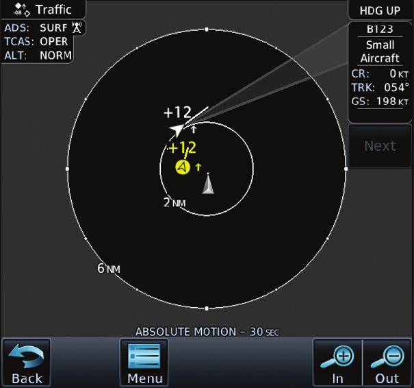
22 4.2 Traffic The GDL 84/88 receives traffic from several sources including external sources (ADS-B, ADS-R, and TIS-B). Additionally, in the GDL 88, onboard sources (TAS/ TCAS) create a single, fused traffic picture for the flight crew. Using relative altitude, relative bearing, range, directionality, ground track, and other identifying information (ICAO address, flight ID, call sign, tail number), the GDL 84/88 determines when tracks from multiple sources represent a single traffic target, selects the most accurate position source for the target, and sends the data to the display. NOTE: The GDL 84/88 observes all ADS-B participants within range. However, due to the nature of TIS-B s service volumes and the incomplete equipage/ adoption of ADS-B Out equipment, NOT ALL TRAFFIC IS OBSERVED by the GDL 84/88. The flight crew must rely on see and avoid procedures to detect and avoid traffic. In addition, when operating on the edges of ATC radar coverage or when using an interfaced active traffic system and TAS/TCAS targets are intermittent, it is possible that a single target aircraft may be briefly or periodically depicted as two grouped targets in the same location Traffic Applications SURF, AIRB, etc When the GDL 88 is interfaced to a certified compatible display unit, a traffic display is available for the flight crew s situational awareness and to enhance the visual acquisition of surrounding traffic. The GNS 400W/500W units do not support all applications, including SURF. The exact location of the ownship as shown by the ownship symbol on the moving map varies by the display device. For GTN units, the tip of the ownship icon, or where the dot is, identifies the exact location. For GNS units, the exact location of the ownship is the center of the ownship icon where the wings cross the fuselage. This display is capable of running in two modes: Airborne Situational Awareness (AIRB) and Surface Situation Awareness (SURF). AIRB is in operation in the en route environment, outside of five NM from and 1,500 feet above the nearest airport. 4-2 Garmin GDL 84/88 ADS-B Transceiver Pilot s Guide Rev. E
 Ownship Icon Traffic Display Radius Map Orientation Selected Traffic Info Touch For Next Target Proximate Non-Directional")
.")
23 * Indicates Multiple Targets. Touch the target to show all targets. Then touch Next to get info on each of the targets. ADS-B and TCAS Status and Altitude Filter Traffic Motion Vector (Green) Ownship Icon Traffic Display Radius Map Orientation Selected Traffic Info Touch For Next Target Proximate Non-Directional Traffic Selected Vector Motion and Duration Touch To View Traffic Menu Figure 4-2 AIRB Display on the GTN 7XX SURF is in operation within the terminal environment (within five NM and less than 1,500 feet above field elevation). When SURF is running, and the zoom scale on the traffic display is less than two NM, the airport environment (including taxiways and runways) is displayed in addition to traffic. This is to aid in situational awareness of runway occupancy/availability, etc. ADS-B and TCAS Status and Altitude Filter Map Orientation Traffic Display Radius Ownship Icon Selected Vector Motion and Duration Touch To View Traffic Menu Figure 4-3 SURF Display on the GTN 7XX Rev. E Garmin GDL 84/88 ADS-B Transceiver Pilot s Guide 4-3
24 Due to the varying precision of the data received via ADS-B, ADS-R, and TIS-B, all traffic targets may not be depicted on the traffic display. Because higher data precision is required for display in the SURF environment, some targets eligible for AIRB will not be displayed while SURF is active. Individual eligibility for AIRB and SURF is depicted in the selected traffic data on the traffic page of both the GTN 6XX and 7XX. NOTE: Displays not capable of SURF will always run the AIRB application On Scene Mode (Helicopter Installations Only) On Scene Mode is a pilot selectable mode which changes the traffic alerting volumes for other ADS-B equipped rotorcraft traffic. This allows operation in closer proximity to other helicopters during operations such as Electronic News Gathering without excessive nuisance alerts. Protection is unchanged for fixed wing traffic and non-ads-b equipped helicopters. The pilot must manually select On Scene Mode on and must select On Scene Mode off after completing operations. Refer to the display Pilot Guide for information about controls and indications Airport Area Alerting A GDL 88 (only) installed in a helicopter and with an interfaced Garmin navigator or Radar Altimeter offers additional traffic alerting in the airport environment uniquely tailored to helicopter operations. When operating at less than 200 feet AGL and less than 60 kts groundspeed, traffic alerting volumes are tailored to minimize nuisance alerts while conducting operations in the airport environment while still providing alerts from airborne aircraft equipped with ADS-B. When in the airport environment alerting envelope, aural traffic alerts are truncated to Traffic and the bearing, distance, and relative altitude information is omitted from the aural alert. No traffic alerts are provided when the GDL 88 equipped helicopter groundspeed is less than 10 kts and within 50 feet of the surface Rotorcraft Installations with No Source of Heading Data The following limitations are applicable to helicopters with a GDL 88 installed but no source of heading data provided to the GDL 88. Because ground track may not correspond to heading at low speeds due to the ability of the helicopter to fly backward or sideways the following limitations apply: 4-4 Garmin GDL 84/88 ADS-B Transceiver Pilot s Guide Rev. E
25 When less than 15 knots, groundspeed ADS-B traffic is not provided to the display for display purposes. Aural traffic alerts will be issued as appropriate. If an active traffic system (TAS/TCAS) is interfaced to the GDL 88 then: TAS/TCAS traffic targets will continue to be provided to the display at all speeds. If in backward or sideward flight in excess of 15 knots, TAS/TCAS and ADS-B tagets will not correlate and two targets will appear on the display for each actual target being received over both ADS-B and TAS/TCAS. If a traffic alert is received under these conditions then two alerts will be generated GDL 88 Integration with TCAD/TAS/TCAS I Figure 4-4 GDL 88 With TCAS Not In Ground Station Coverage When an active traffic system is interfaced with a GDL 88, the GDL 88 receives traffic from the active traffic system and attempts to match (or correlate ) this traffic with ADS-B traffic that the GDL 88 is tracking. When a correlation is made, the target with the most accurate information is displayed to the flight crew. Any active traffic system or ADS-B traffic that is not correlated is also displayed for the flight crew. The correlation of traffic by the GDL 88 ensures that only the most accurate, and no duplicate, traffic targets are displayed for the flight crew s situational awareness Rev. E Garmin GDL 84/88 ADS-B Transceiver Pilot s Guide 4-5
26 When interfaced to a TAS or TCAS system, traffic alerts are provided as follows: Traffic Correlated? TAS/TCAS Alert Active? CSA Alert Active? Aural Alert Source Visual Alert Source Yes Yes N/A TCAS/TAS TCAS/TAS Yes No N/A None None No Yes Yes TCAS/TAS (prioritized) GDL 88 TCAS/TAS GDL 88 No No Yes GDL 88 GDL 88 Table 4-1 TAS/TCAS Traffic Alerts NOTE: Aural traffic alerts from the GDL 88 are suppressed when below 500 feet Radar Altitude or Height Above Terrain. When a GDL 88 and TAS/TCAS system are integrated, the GDL 88 controls the Altitude Display and operating mode of the TAS/TCAS system using the air/ ground logic in the GDL 88, as well as from the mode controls available on the interfaced display No-Heading Source Traffic Information When a GDL 88 and TAS/TCAS are integrated in an aircraft without a heading source, they are subject to the following limitations: While on the ground, display of TCAS traffic and ADS-B traffic are mutually exclusive. TCAS (heading referenced traffic) and ADS-B traffic are allowed to be displayed on the traffic page concurrently in a Track Up orientation while airborne, but bearing of the TCAS targets relative to ADS-B targets are slewed by the crab angle of the aircraft. Traffic is not displayed on the moving map with ground features depicted. Traffic is always available for display on the traffic page Conflict Situational Awareness (CSA) Conflict Situational Awareness is an alerting algorithm that provides TCASlike Traffic Alerts on ADS-B, ADS-R, and TIS-B targets to enhance situational awareness. The GDL 84/88 issues an aural alert when a Conflict Situational Awareness (CSA) alert is displayed, for example Traffic! Two O clock, Low, Two Miles. 4-6 Garmin GDL 84/88 ADS-B Transceiver Pilot s Guide Rev. E
27 As in some TCAS I TA implementations, altitude above terrain is used to adjust the sensitivity of the CSA algorithm to minimize nuisance alerts. Radar Altitude (if available), Height Above Terrain (as provided by a GNS or GTN navigator with a terrain database), and Geodetic Altitude are used to adjust the sensitivity of the CSA algorithm in accordance with the following table: Sensitivity Level Radar Altitude (feet) 4 Up to 1000 (RA or HAT) Height Above Terrain (HAT) (if Available)* GPS Phase of Ownship Alt Look- Vertical Flight* (feet) Ahead Threshold Time(s) for Alarm (sec) (feet) Any Any Any Incremental Protected Volume (NM) 4 Unavailable Any Any Any Unavailable Unavailable Approach Any >1000 <= Unavailable >1000 <=2350 Any Any Any Any Any Unavailable Unavailable Terminal Any Unavailable or > Unavailable or > Unavailable or > Unavailable or >2350 Unavailable or >2350 Unavailable or >2350 Unavailable or >2350 Unavailable or >2350 Not approach and not Terminal (including unavailable) Not approach and not Terminal (including unavailable) Not approach and not Terminal (including unavailable) Not approach and not Terminal (including unavailable) <= >5000 <=10,000 >10,000 <=20,000 >20,000 <=42, Rev. E Garmin GDL 84/88 ADS-B Transceiver Pilot s Guide 4-7
28 Sensitivity Level Radar Altitude (feet) 10 Unavailable or >2350 Height Above Terrain (HAT) (if Available)* Unavailable or >2350 * Not available with the GDL 84. GPS Phase of Flight* Not approach and not Terminal (including unavailable) Table 4-2 Traffic Alert Functionality Ownship Alt Look- Vertical Incremental (feet) Ahead Threshold Protected Time(s) for Alarm Volume (NM) (sec) (feet) > 42, Garmin GDL 84/88 ADS-B Transceiver Pilot s Guide Rev. E
29 5 WEATHER The Flight Information Services (FIS-B) function is capable of displaying textual and graphic weather information. No subscription for FIS-B services is required. FIS-B is based on a ground-to-air data link that requires the aircraft to be within reception range of the Ground Broadcast Transceiver (GBT). FIS-B weather products are transmitted from the UAT (978 MHz) ground stations on a regular basis, in accordance with the following table: Weather Product Expiration Time (Minutes) Transmission Interval (Minutes) Update Interval (Minutes) CONUS NEXRAD Regional NEXRAD AIRMETs 60 5 As Available (Typically 20 minutes) SIGMETs 60 5 As Available (Typically 20 minutes), then at 15 minute intervals for 1 hour METARs minute (where available), As Available otherwise (Typically 20 minutes) Winds and Temperatures Aloft Pilot Weather Report (PIREP) (Blue - Regular, Yellow - Urgent) 90 or at the end of the valid period hours As available (Typically 20 minutes) TAFs hours NOTAMs As available (Typically 20 minutes) Table 5-1 FIS-B Weather Products and Aging Rev. E Garmin GDL 84/88 ADS-B Transceiver Pilot s Guide 5-1

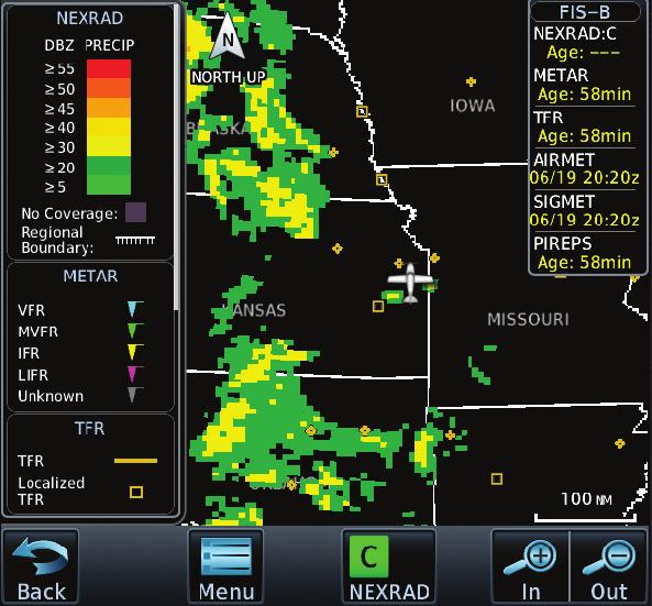
30 WARNING: Do not use the indicated data link weather product age to determine the age of the weather information shown by the data link weather product. Due to time delays inherent in gathering and processing weather data for data link transmission, the weather information shown by the data link weather product may be significantly older than the indicated weather product age. WARNING: Weather data received by the GDL 84 may be displayed on personal electronic devices, such as tablets, via Flight Stream. This information merely supplemental and advisory in nature and is not intended to be relied upon for safety-critical operations. 5.1 FIS-B NEXRAD WSR-88D weather surveillance radar or NEXRAD (NEXt generation RADar) is a Doppler radar system that has greatly improved the detection of meteorological events such as thunderstorms, tornadoes, and hurricanes. An extensive network of NEXRAD stations provides almost complete radar coverage of the continental United States, Alaska, and Hawaii. The unobstructed range of each NEXRAD is 124 nautical miles. FIS-B is a graphic weather display overlaid on the map indicating the rainfall detected by ground based radar for a specific area. Colors are used to identify the different NEXRAD echo intensities (reflectivity) measured in dbz, decibels of reflectivity (Z). Reflectivity is the amount of transmitted power returned to the radar receiver. The dbz values increase as returned signal strength increases. Precipitation intensity is displayed using colors corresponding to the dbz values. An example of how precipitation data is color coded follows: Figure 5-1 Sample FIS-B Weather Precipitation Legend 5-2 Garmin GDL 84/88 ADS-B Transceiver Pilot s Guide Rev. E
31 NOTE: FIS-B NEXRAD does not differentiate between frozen and liquid precipitation. The FIS-B NEXRAD intensity colors (as shown) may differ from the intensity colors from other providers. NOTE: FIS-B information including weather information, NOTAMs, and TFR areas, are intended to be used for pilot planning decisions and pilot near-term decisions focused on avoiding areas of inclement weather that are beyond visual range or where poor visibility precludes visual acquisition of inclement weather. The system lacks sufficient resolution and updating capability necessary for aerial maneuvering associated with immediate decisions NEXRAD Abnormalities There are possible abnormalities regarding displayed NEXRAD images. Some, but not all, causes of abnormal displayed information include: Ground Clutter Strobes and spurious radar data Sun strobes, when the radar antenna points directly at the sun Military aircraft deploy metallic dust which can cause alterations in radar scans Interference from buildings or mountains, which may cause shadows Scheduled maintenance may put a radar off-line NEXRAD Limitations Certain limitations exist regarding the NEXRAD radar displays. Some, but not all, are listed for the user s awareness: The (high resolution) Regional NEXRAD pixels are 1.5 minutes (1.5 nautical miles = 2.78 km) wide by 1 minute (1 nautical miles = km) tall. The (medium resolution 5 times larger than high resolution) CONUS NEXRAD pixels are 7.5 minutes (7.5 nautical miles = km) wide by 5 minutes (5 nautical miles = 9.26 km) wide. Above 60 degrees of latitude the block widths double to 3 minutes/nautical miles for Regional (no CONUS above 60 degrees) Rev. E Garmin GDL 84/88 ADS-B Transceiver Pilot s Guide 5-3
. The display of the information is color-coded to indicate the weather level severity.")

32 5.1.3 NEXRAD When enabled, NEXRAD weather information is shown. Mosaic data from all of the NEXRAD radar sites in the United States is shown. This data is composed of the maximum reflectivity from the individual radar sweeps (i.e. composite reflectivity). The display of the information is color-coded to indicate the weather level severity. The NEXRAD option has selections of Regional, CONUS, or Combined NEXRAD (only available with GTN units). CONUS NEXRAD includes a composite of available NEXRAD radar imagery across the 48 states. Regional NEXRAD is a composite of available NEXRAD radar imagery in a local area, showing a more detailed image than CONUS NEXRAD. FIS-B weather data reception requires line-of-site communication between the receiver and the ADS-B ground station. Incomplete Regional and/or CONUS NEXRAD imagery displayed on the MAP and FIS-B Weather Pages of the affected products is an indicator of poor FIS-B reception. Examples below display areas where FIS-B data is degraded due to poor reception: GNS GTN Figure 5-2 Examples of Areas Where FIS-B Reception Is Unavailable 5-4 Garmin GDL 84/88 ADS-B Transceiver Pilot s Guide Rev. E
33 Affected Areas Any area in the continental United States (CONUS) or Alaska where the distance from ADS-B ground stations or the combined effect of distance and low altitude is sufficiently great to cause poor reception. A good source of information for ground station coverage can be found at Due to line-of-sight broadcast characteristics, operators with properly installed and functioning equipment may still receive incomplete FIS-B data when signal reception is limited by the distance from ground stations combined with a low altitude. Continental US (CONUS) NEXRAD The Display CONUS NEXRAD selection shows NEXRAD radar information for the entire continental United States. CONUS NEXRAD data is updated every 15 minutes. The resolution of displayed CONUS NEXRAD data is approximately 5.4 NM (10 kilometers). The intensity level reflected by the pixel is the highest level sampled within the area covered by each pixel. Regional NEXRAD The Regional NEXRAD selection shows regional NEXRAD radar information within 250 miles of the aircraft location. Regional NEXRAD data is updated every 5 minutes (10 minutes for clear air mode). Combined NEXRAD Regional NEXRAD data within 500 NM of the aircraft location and CONUS NEXRAD data everywhere else. The two types of NEXRAD are separated by a white stippled border. This boundary is updated whenever new Regional or CONUS NEXRAD data is received. 5.2 FIS-B TFRs Temporary Flight Restrictions (TFRs) provide detailed information for local short term restrictions. The update rate is approximately every 20 minutes. NOTE: Some TFRs may not be shown or information may be incomplete. The presented TFR information is only advisory in nature. Check official sources, such as from preflight planning or Flight Service Station to determine more complete TFR information Rev. E Garmin GDL 84/88 ADS-B Transceiver Pilot s Guide 5-5
34 5.3 FIS-B METARs When enabled, graphic METARs (METeorological Aviation Reports) are shown as colored flags at airports that provide METAR reports. Press the METARs key to enable or disable METARs. Refer to the legend for a description of the color code. The update rate is every five minutes. NOTE: Due to infrastructure issues, all METARs may not be reported and available for display. METAR Symbol Description VFR (ceiling greater than 3000 ft. AGL and visibility greater than five miles) Marginal VFR (ceiling ft. AGL and/or visibility three to five miles) IFR (ceiling 500 to below 1000 ft. AGL and/or visibility one mile to less than three miles) Low IFR (ceiling below 500 ft. AGL or visibility less than one mile) Unknown Table 5-2 METAR Symbols 5-6 Garmin GDL 84/88 ADS-B Transceiver Pilot s Guide Rev. E
35 5.4 FIS-B PIREPs Pilot Weather Reports (PIREPs) provide timely weather information. When significant weather conditions are reported or forecast, Air Traffic Control (ATC) facilities are required to solicit PIREPs. PIREPs may contain non-forecast adverse weather conditions, such as low in-flight visibility, icing conditions, wind shear, and turbulence. PIREPs are issued as either Routine (UA) or Urgent (UUA). The update rate is approximately every 20 minutes. 5.5 FIS-B Winds and Temperatures Aloft Winds and Temperatures Aloft data shows the forecast wind speed, direction, and Temperature at selected altitudes. Altitudes can be selected in increments from the 1,000 feet up to 53,000 feet. The update rate is every 12 hours. 5.6 SIGMETs and AIRMETs SIGMETs (SIGnificant METerological Information) and AIRMETs (AIRmen s METerological Information) are broadcast for potentially hazardous weather considered of importance to flight crews. The update rate is approximately every 20 minutes Rev. E Garmin GDL 84/88 ADS-B Transceiver Pilot s Guide 5-7
36 This page intentionally left blank 5-8 Garmin GDL 84/88 ADS-B Transceiver Pilot s Guide Rev. E
37 6 INSTALLATION CONFIGURATIONS 6.1 Installation Configurations GDL 88 with ADS-B Out Transmission Enabled The GDL 88 can provide for both the ADS-B Out and ADS-B In functionality. In this case, the GDL 88 transmits ADS-B messages on 978 MHz and receives ADS-B, ADS-R, TIS-B, and FIS-B services on the 1090 and 978 MHz links using its dual link receive capabilities. This configuration is limited by 14 CFR to use below FL GDL 88 with ADS-B Out Transmission Disabled In this case, the GDL 88 receives ADS-B, ADS-R, TIS-B, and FIS-B services on the 1090 and 978 MHz links using its dual link receive capabilities. In order for the ADS-B Out mandate to be met, another LRU, such as a Garmin GTX 330ES transponder, is required. For aircraft operated above FL180, a 1090 MHz ADS-B Out compliant system is required GDL 84/88 Only No Display In a minimal installation, the GDL 84/88 provides the required ADS-B Out functionality. This configuration requires standalone annunciators and control switches in the cockpit. An optional traffic annunciation light in the cockpit can provide visual CSA alerts. As a configuration option, Aural alerts can provide for these threat aircraft, to include directionality from the ownship and range External ADS-B Annunciator The external ADSB annunciator is only required when the GDL 84/88 is not interfaced to a compatible control display unit and is always required for GDL 84/88 installations. When one or more GDL 84/88 faults are present, the ADS-B annunciator activates one or both of two lights to indicate the presence and type of the highest priority GDL 84/88 fault present. For example, if both a No Position (priority 2) fault and a Fault (priority 3) are present, the ADS-B annunciator will indicate the presence of a No Position fault. In the single annunciator configuration, within the first 20 seconds after power up the light will flash if the unit has a fault that requires service. The faults that cause the flashing do not directly impact the capability for the GDL 84/88 to provide rule compliant ADS-B Out transmissions. They do, however, require attention/service and could degrade the overall performance of the GDL 84/88. A solid annunciator light may be caused by the following: a Rev. E Garmin GDL 84/88 ADS-B Transceiver Pilot s Guide 6-1
 Activated Both NO POSN Description A GDL 84/88 internal malfunction, antenna")

38 GDL 84/88 internal malfunction, antenna malfunction, incorrect setting, or other fault that is preventing ADS-B transmission or normal operation of the GDL 84/88. Reporting Fault Type Priority 1 Transmit Fail 2 No Position Figure 6-1 Dual Annunciator ADS-B Annunciator Light(s) Activated Both NO POSN Description A GDL 84/88 internal malfunction, antenna malfunction, or incorrect configuration setting prevent transmission. The GDL 84/88 is not receiving GPS position. 3 Fault FAULT A GDL 84/88 or external fault prevent proper operation of the GDL 84/ No Fault Neither No fault present. Table 6-1 GDL 84/88 Fault Types (Dual Annunciators) Fault Type Transmit Fail/ Fault Figure 6-2 Single Annunciator ADS-B Annunciator State Solid On Description ADS-B Out not transmitting or transmissions are not rule compliant. Fault Flashing at Power On The GDL 84/88 has a non-critical fault. See your dealer for service. No Fault Neither No fault present. Table 6-2 GDL 84/88 Fault Types (Single Annunciator) 6-2 Garmin GDL 84/88 ADS-B Transceiver Pilot s Guide Rev. E
39 6.2 Interfaces Audio Panel Traffic alert audio output can be interfaced to a audio panel with a compatible unswitched unmuted audio input. This is optional for no display installations Altitude Source The GDL 84/88 requires the use of ownship pressure altitude for transmission of required ADS-B Out data values and to calculate the vertical separation and vertical closure from target aircraft Heading Source (optional) The GDL 84/88 can optionally use heading for inclusion in the ADS-B message. Additionally, the GDL 88 can optionally use heading for the purpose of correlating ADS-B traffic and traffic received from the external traffic system. Heading is provided to the GDL 88 from any compatible magnetic heading source. Multiple heading sources may be connected to the the GDL 84/88. See section for details about the display of traffic when a heading source is not provided GPS Position Source The GDL 84/88 uses the ownship GPS position for creation of the ADS-B Out messages as well as the receipt and tracking of ADS-B In targets. The GDL 88 without the internal GPS WAAS requires at least one compatible GPS position source be installed, while the GDL 88 with the internal GPS WAAS engine may optionally be interfaced with compatible sources. The GDL 84 has an internal GPS WAAS engine and does not accept an external GPS source Radar Altimeter (Optional) The GDL 84/88 can optionally be interfaced with a radar altimeter to drive the sensitivity level of the Conflict Situational Awareness (CSA) application Traffic Mute (Optional) The GDL 84/88 can optionally interface with a pilot controlled switch to acknowledge an active Conflict Situational Awareness (CSA) alert and mute the associated aural alert. This momentary switch only mutes the current CSAs and does not act as an inhibit for future CSA aural annunciations Rev. E Garmin GDL 84/88 ADS-B Transceiver Pilot s Guide 6-3
40 6.2.7 Flight Stream Interface (Optional) The GDL 84/88 can optionally be interfaced to a Flight Stream unit. This will enable the GDL 84/88 traffic, weather, and GPS position to be displayed on a wireless mobile device. 6-4 Garmin GDL 84/88 ADS-B Transceiver Pilot s Guide Rev. E
41 7 GLOSSARY ADS-B ADS-B In ADS-B Out ADS-R AIRB Anonymous Mode Automatic Dependent Surveillance Broadcast (ADS B) is an advanced surveillance technology that combines an aircraft s positioning source, aircraft avionics, and a ground infrastructure to create an accurate surveillance interface between aircraft and ATC. ADS B In refers to an appropriately equipped aircraft s ability to receive and display another aircraft s ADS B Out information as well as the ADS B In services provided by ground systems, including Automatic Dependent Surveillance Rebroadcast (ADS R), Traffic Information Service Broadcast (TIS B), and, if so equipped, Flight Information Service Broadcast (FIS B). ADS B Out provides air traffic controllers and other aircraft with real-time position information that is, in most cases, more accurate than the information available with current radar-based systems. With more accurate information, ATC is able to position and separate aircraft with improved precision and timing. Automatic Dependent Surveillance-Rebroadcast (ADS R) collects traffic information from each broadcast link and rebroadcasts it to ADS B In equipped aircraft on the other broadcast link. Airborne Situational Awareness is an ADS-B In application that provides the ADS-B and external traffic system targets on a display to be used by the flight crew for situational awareness. The Anonymous Mode, when armed, will replace the Flight ID with a temporary randomized number for privacy while the position information will still be provided. CSA Conflict Situational Awareness. A traffic alerting feature to increase flight crew situational awareness of traffic situations that could lead to a hazardous condition in the near term. Extended Squitter With Extended Squitter capabilities, position, velocity, and heading information are automatically transmitted by the 1090 transponder to other aircraft and ground stations Rev. E Garmin GDL 84/88 ADS-B Transceiver Pilot s Guide 7-1
42 FIS-B Flight Information Services-Broadcast. FIS-B is a graphic weather display capable of displaying graphical weather information on UAT equipped installations. FIS-B is available free to any operator with the ability to receive and display the data that is broadcast on the Universal Access Transceiver (UAT) or the 978 MHz link. Ground Clutter GPS A form of radar signal interference that occurs when fixed objects close to the transmitter such as buildings, trees, or terrain (hills, ocean swells and waves) obstruct a radar beam and produce echoes. Global Positioning System. A space-based Navigation system providing accurate position, velocity and time information. HAT HSDB Height Above Terrain Garmin s proprietary High Speed Data Bus (Ethernet). ICAO International Civil Aviation Organization. PABI Pressure Altitude Broadcast Inhibit. SBAS STC SURF Satellite-Based Augmentation System. Supplemental Type Certificate Surface Situation Awareness. An ADS-B In application that provides the ADS-B and external traffic system targets on a display to be used by the flight crew for situational awareness. TA TAS TCAD TCAS Traffic Advisory. Traffic Advisory System. Traffic Collision Avoidance Device. Traffic Collision Avoidance System. An aircraft collision avoidance system designed to reduce the incidence of midair collisions between aircraft. It monitors the airspace around an aircraft for other aircraft equipped with a corresponding active transponder, independent of air traffic control, and warns pilots of the presence of other transponder-equipped aircraft which may present a threat of mid-air collision. 7-2 Garmin GDL 84/88 ADS-B Transceiver Pilot s Guide Rev. E
43 TIS-B Traffic Information Services-Broadcast. TIS-B supplements ADS-B s air-to-air services to provide more situational awareness in the cockpit of all traffic known to the ATC system. The ground TIS-B station transmits surveillance target information on the ADS-B data link for unequipped targets or targets transmitting only on another ADS-B link. TIS-B is a free service available to aircraft operators equipped with ADS-B Out and ADS-B In. UAT Universal Access Transceiver. The GDL 84/88 UAT transmits ADS-B Out data on the 978 MHz (UAT) frequency. The GDL 84/88 UAT receives ADS-B, ADS-R, TIS-B, and FIS-B on 978 MHz. XPDR Transponder. The equipment which broadcasts aircraft code, altitude and other information to ground facilities and other aircraft Rev. E Garmin GDL 84/88 ADS-B Transceiver Pilot s Guide 7-3
44 This page intentionally left blank 7-4 Garmin GDL 84/88 ADS-B Transceiver Pilot s Guide Rev. E
45 8 APPENDIX 8.1 Troubleshooting If efforts to resolve the problem fail, contact your dealer or customer service for technical assistance. Please have the following information ready: System configuration (products, antennas, mounting locations, etc.) Model No., part number, and serial number Software versions Description of the problem Efforts made to isolate/solve the problem Garmin International, Inc. Aviation Products Customer Service Department 1200 East 151st Street Olathe, KS USA Servicing Your Unit The Garmin GDL 84/88 has no user-serviceable parts. Should you ever encounter a problem with your unit, take it to an authorized Garmin dealer for repairs, or contact Garmin Product Support at The GDL 84/88 is sealed to protect the unit. Any attempt to open the case to change or modify the unit in any way voids your warranty and may result in permanent damage to the equipment. 8.3 Contact Garmin Contact Garmin if you have any questions while using your GDL 84/88. In the USA, contact Garmin Product Support by phone: (913) or (866) , Monday Friday, 7 AM 7 PM Central Time; or go to: In Europe, contact Garmin (Europe) Ltd. at +44 (0) (outside the UK) or (within the UK) Rev. E Garmin GDL 84/88 ADS-B Transceiver Pilot s Guide 8-1
46 8.4 Software License Agreement BY USING THE GDL 84/88, YOU AGREE TO BE BOUND BY THE TERMS AND CONDITIONS OF THE FOLLOWING SOFTWARE LICENSE AGREEMENT. PLEASE READ THIS AGREEMENT CAREFULLY. Garmin grants you a limited license to use the software embedded in this device (the Software ) in binary executable form in the normal operation of the product. Title, ownership rights, and intellectual property rights in and to the Software remain with Garmin. You acknowledge that the Software is the property of Garmin and is protected under the United States of America copyright laws and international copyright treaties. You further acknowledge that the structure, organization, and code of the Software are valuable trade secrets of Garmin and that the Software in source code form remains a valuable trade secret of Garmin. You agree not to decompile, disassemble, modify, reverse assemble, reverse engineer, or reduce to human readable form the Software or any part thereof or create any derivative works based on the Software. You agree not to export or re-export the Software to any country in violation of the export control laws of the United States of America. 8-2 Garmin GDL 84/88 ADS-B Transceiver Pilot s Guide Rev. E
47 8.5 LIMITED WARRANTY All Garmin avionics products are warranted to be free from defects in materials or workmanship for: two years from the date of purchase for new Remote-Mount and Panel-Mount products; one year from the date of purchase for new portable products and any purchased newly-overhauled products; six months for newly-overhauled products exchanged through a Garmin Authorized Service Center; and 90 days for factory repaired or newly-overhauled products exchanged at Garmin in lieu of repair. Within the applicable period, Garmin will, at its sole option, repair or replace any components that fail in normal use. Such repairs or replacement will be made at no charge to the customer for parts or labor, provided that the customer shall be responsible for any transportation cost. This warranty does not apply to: (i) cosmetic damage, such as scratches, nicks and dents; (ii) consumable parts, such as batteries, unless product damage has occurred due to a defect in materials or workmanship; (iii) damage caused by accident, abuse, misuse, water, flood, fire, or other acts of nature or external causes; (iv) damage caused by service performed by anyone who is not an authorized service provider of Garmin; or (v) damage to a product that has been modified or altered without the written permission of Garmin. In addition, Garmin reserves the right to refuse warranty claims against products or services that are obtained and/or used in contravention of the laws of any country. THE WARRANTIES AND REMEDIES CONTAINED HEREIN ARE EXCLUSIVE AND IN LIEU OF ALL OTHER WARRANTIES, WHETHER EXPRESS, IMPLIED OR STATUTORY, INCLUDING ANY LIABILITY ARISING UNDER ANY WARRANTY OF MERCHANTABILITY OR FITNESS FOR A PARTICULAR PURPOSE, STATUTORY OR OTHERWISE. THIS WARRANTY GIVES YOU SPECIFIC LEGAL RIGHTS, WHICH MAY VARY FROM STATE TO STATE. IN NO EVENT SHALL GARMIN BE LIABLE FOR ANY INCIDENTAL, SPECIAL, INDIRECT OR CONSEQUENTIAL DAMAGES, WHETHER RESULTING FROM THE USE, MISUSE OR INABILITY TO USE THE PRODUCT OR FROM DEFECTS IN THE PRODUCT. SOME STATES DO NOT ALLOW THE EXCLUSION OF INCIDENTAL OR CONSEQUENTIAL DAMAGES, SO THE ABOVE LIMITATIONS MAY NOT APPLY TO YOU. Garmin retains the exclusive right to repair or replace (with a new or newly-overhauled replacement product) the product or software or offer a full refund of the purchase price at its sole discretion. SUCH REMEDY SHALL BE YOUR SOLE AND EXCLUSIVE REMEDY FOR ANY BREACH OF WARRANTY. Online Auction Purchases: Products purchased through online auctions are not eligible for warranty coverage. Online auction confirmations are not accepted for warranty verification. To obtain warranty service, an original or copy of the sales receipt from the original retailer is required. Garmin will not replace missing components from any package purchased through an online auction. International Purchases: A separate warranty may be provided by international distributors for devices purchased outside the United States depending on the country. If applicable, this warranty is provided by the local in-country distributor and this distributor provides local service for your device. Distributor warranties are only valid in the area of intended distribution. Devices purchased in the United States or Canada must be returned to the Garmin service center in the United Kingdom, the United States, Canada, or Taiwan for service. To obtain warranty service, contact your local Garmin Authorized Service Center. For assistance in locating a Service Center near you, visit the Garmin web site at fly-garmin, or contact Garmin Customer Service at Rev. E Garmin GDL 84/88 ADS-B Transceiver Pilot s Guide 8-3
48 This page intentionally left blank 8-4 Garmin GDL 84/88 ADS-B Transceiver Pilot s Guide Rev. E
49 INDEX A ADS-B 2-2 ADS-B annunciator 6-1 ADS-B In 4-1 ADS-B Out 3-1, 6-1 ADS-R 2-3 AIRB 4-2 Air/Ground 3-3 AIRMETs 5-1, 5-7 Airport area alerting 4-4 Airports 5-6 Altitude 6-3 Anonymous mode 3-3 Antenna 5-3 Appendix 8-1 Audio panel 6-3 C Combined NEXRAD 5-5 Conflict situational awareness 4-6, 6-3 Contact Garmin 8-1 Continental US NEXRAD 5-5 CONUS 5-1, 5-5 Correlation 4-5 CSA 4-6, 6-3 Customer service 8-1, 8-3 E Extended squitter 1-1, 7-1 External annunciator 6-1 F FIS-B 2-5 Flight Stream 6-4 G GBT 5-1 GDL 84/88 System Functions 1-1 Glossary 7-1 GPS 6-3 Graphical Weather 5-2, 7-2 H Heading 6-3 Height above terrain 4-7 Hurricanes 5-2 I IFR 5-6 Installation configuration 6-1 Interfaces 6-3 L Limitations 5-3 M METARs 5-1, 5-6 Mode S 1-1, 3-3 Mountains 5-3 N NEXRAD 5-4 No display 6-1 No heading source 4-6 No position fault 6-1 No source of heading data 4-4 Notes i, 2-4, 3-2, 4-2, 4-4, 4-6, 5-3, 5-5 O On scene mode 4-4 P PABI 3-2 PIREP 5-1, 5-7 Pressure Altitude Broadcast Inhibit 3-2 Product Support 8-1 R Radar 5-2 Radar altimeter 6-3 Radar altitude 4-7 Record of Revisions iii Regional NEXRAD 5-1, Rev. E Garmin GDL 84/88 ADS-B Transceiver Pilot s Guide Index-1
50 S Self-interrogation 3-2 Services 5-1 Servicing your unit 8-1 SIGMET 5-1, 5-7 Software license 8-2 SURF 4-2 T TAS 1-2, 4-2 TCAD 1-2 TCAS 1-2, 4-2 Text 5-1 TFR 5-5 Thunderstorm 5-2 Time 5-1 TIS-B 2-4 Tornados 5-2 Troubleshooting 8-1 V VFR 3-3, 5-6 W Warnings i, 5-2 Warranty 8-3 Weather 5-1 Wind 5-1 Winds aloft 5-1, 5-7 Index-2 Garmin GDL 84/88 ADS-B Transceiver Pilot s Guide Rev. E
51
 Ltd. Liberty House, Bulls Copse Road, Hounsdown Business Park, Southampton, SO40 9LR, U.K. Tel. +44 (0) 23 8052 4000 Fax +44 (0) 23 8052 4004 GARMIN Corporation No.")
52 2014 GARMIN Corporation GARMIN International, Inc East 151 st Street, Olathe, Kansas 66062, U.S.A. Tel. 913/ or 866/ Fax 913/ Garmin AT, Inc Turner Rd., S.E., Salem, Oregon 97302, U.S.A. Tel. 503/ or 800/ Fax. 503/ Garmin (Europe) Ltd. Liberty House, Bulls Copse Road, Hounsdown Business Park, Southampton, SO40 9LR, U.K. Tel. +44 (0) Fax +44 (0) GARMIN Corporation No. 68, Zhangshu 2 nd Road, Xizhi Dist., New Taipei City 221, Taiwan Tel. 886/ Fax 886/ Garmin Singapore Pte. Ltd. 46 East Coast Road #05-06 Eastgate Singapore Tel. (65) Fax (65) Part Number Rev. E
400/500 Series GTS 8XX Interface. Pilot s Guide Addendum
 400/500 Series GTS 8XX Interface Pilot s Guide Addendum Copyright 2010 Garmin Ltd. or its subsidiaries. All rights reserved. This manual reflects the operation of Software version 5.03 or later for 4XX
GTS Traffic Systems. Pilot s Guide
 GTS Traffic Systems Pilot s Guide 2014 Garmin Ltd. or its subsidiaries. All rights reserved. Garmin International, Inc., 1200 East 151st Street, Olathe, KS 66062, U.S.A. Tel: 913/397.8200 Fax: 913/397.8282
GTS 8XX Series. Pilot s Guide Traffic Advisory System
 GTS 8XX Series Pilot s Guide Traffic Advisory System 2009 Garmin Ltd. or its subsidiaries. All rights reserved. Garmin International, Inc., 1200 East 151st Street, Olathe, KS 66062, U.S.A. Tel: 913/397.8200
There s a Lynx NGT-series solution to fit any need. MODEL COMPARISON. ADS B Out MHz Mode S ES. p p p p. ADS B In. 978 MHz UAT p p p p
 There s a Lynx NGT-series solution to fit any need. MODEL COMPARISON ADS B Out LYNX NGT-9000 NGT-9000+ NGT-9000D NGT-9000D+ 1090 MHz Mode S ES ADS B In 978 MHz UAT 1090 MHz Internal WAAS/GPS Wi-Fi Capable
KMD 550/850. Traffic Avoidance Function (TCAS/TAS/TIS) Pilot s Guide Addendum. Multi-Function Display. For Software Version 01/13 or later
 Pilot s Guide Addendum. Multi-Function Display. For Software Version 01/13 or later") N B KMD 550/850 Multi-Function Display Traffic Avoidance Function (TCAS/TAS/TIS) Pilot s Guide Addendum For Software Version 01/13 or later Revision 3 Jun/2004 006-18238-0000 The information contained
N B KMD 550/850 Multi-Function Display Traffic Avoidance Function (TCAS/TAS/TIS) Pilot s Guide Addendum For Software Version 01/13 or later Revision 3 Jun/2004 006-18238-0000 The information contained
Copyrighted Material - Taylor & Francis
 22 Traffic Alert and Collision Avoidance System II (TCAS II) Steve Henely Rockwell Collins 22. Introduction...22-22.2 Components...22-2 22.3 Surveillance...22-3 22. Protected Airspace...22-3 22. Collision
GTX 320A. Mode A/C Transponder. pilot s guide
 GTX 320A Mode A/C Transponder pilot s guide 2000 GARMIN Corporation GARMIN International, Inc. 1200 East 151 st Street, Olathe, Kansas 66062, U.S.A. Tel. 913/397.8200 or 800/800.1020 Fax 913/397.8282 GARMIN
KGX 150/130 ADS -B Certified Transceivers & Receivers
 BendixKing By Honeywell 9201 -B San Mateo Blvd. NE Albuquerque, NM 87113 U.S.A. CAGE: 6PC31 Telephone: 1-505 -903-6148 Telephone: 1-855 -250-7027 (Toll Free in U.S.A.) Web site: http://www.bendixking.com
RECORD OF REVISIONS. Revisions to this Supplement are recorded in the following table.
 Supplement D42L AFM RECORD OF REVISIONS Revisions to this Supplement are recorded in the following table. New or amended text will be indicated by a bold black vertical line in the left hand margin of
ADS-B Primer. FlyQ EFB from Seattle Avionics. A pilot s guide to practical ADS-B information without the acronyms
 FlyQ EFB from Seattle Avionics ADS-B Primer A pilot s guide to practical ADS-B information without the acronyms Updated October 15, 2014 Steve Podradchik Summary FlyQ EFB includes support for in-flight
2000 by UPS Aviation Technologies, Inc. All rights reserved. Printed in the U.S.A.
 No part of this document may be reproduced in any form or by any means without the express written consent of UPS Aviation Technologies, Inc. UPS Aviation Technologies, Inc., II Morrow, and Apollo are
GDL 69/69A XM Satellite Radio Activation Instructions
 GDL 69/69A XM Satellite Radio Activation Instructions 190-00355-04 2008 Rev. H This Page Intentionally Left Blank 2004-2008 Garmin Ltd. or its subsidiaries All Rights Reserved Except as expressly provided
GDL 69 Series XM Satellite Radio Activation Instructions
 GDL 69 Series XM Satellite Radio Activation Instructions 190-00355-04 2012 This page intentionally left blank 2004-2012 Garmin Ltd. or its subsidiaries All Rights Reserved Except as expressly provided
Pilot s Guide for Models NGT NGT-9000D
 for Models NGT-9000+ NGT-9000D Aviation Products Document Precedence This provides general information about the operation of the NGT-9000. Refer to your FAA-approved Airplane Flight Manual (AFM) and its
400W / 500W Series Display Interfaces
 400W / 500W Series Display Interfaces Pilot s Guide Addendum L-3 STORMSCOPE WX-500 Weather Mapping Sensor L-3 SKYWATCH Traffic Advisory System (Model SKY497) L-3 SKYWATCH HP Traffic Advisory System (Model
Exelis FIS-B: Status & Future Presentation for Friends & Partners in Aviation Weather 2014
 Exelis FIS-B: Status & Future Presentation for Friends & Partners in Aviation Weather 2014 Paul Freeman July 22, 2014 Surveillance and Broadcast Services (SBS) Program Copyright 2014 Exelis Inc. Exelis
Understanding ADS-B traffic
 Understanding ADS-B traffic 24 August 2012 Advanced Tips 26 comments The Garmin Pilot app, when paired with a GDL 39, can display ADS-B traffic. ADS-B has suddenly become a household word among pilots,
Pilot s Guide for Models
 for Models NGT-9000 NGT-9000+ NGT-9000D NGT-9000R NGT-9000R+ NGT-9000RD Aviation Products Document Precedence This provides general information about the operation of the NGT-9000. Refer to your FAA-approved
Automatic Dependent Surveillance -ADS-B
 ASECNA Workshop on ADS-B (Dakar, Senegal, 22 to 23 July 2014) Automatic Dependent Surveillance -ADS-B Presented by FX SALAMBANGA Regional Officer, CNS WACAF OUTLINE I Definition II Principles III Architecture
ADS-B Ruling and FreeFlight Systems new ADS-B solutions
 ADS-B Ruling and FreeFlight Systems new ADS-B solutions EAA-Oshkosh July 2010 FreeFlight Systems Proprietary Data What is ADS-B? Current Radar System Interrogation from radar Receives response from aircraft
Pilot s Guide for Models
 for Models NGT-9000 NGT-9000+ NGT-9000D NGT-9000D+ NGT-9000R NGT-9000R+ NGT-9000RD NGT-9000RD+ Aviation Products Document Precedence This provides general information about the operation of the NGT-9000.
TCAS Functioning and Enhancements
 TCAS Functioning and Enhancements Sathyan Murugan SASTRA University Tirumalaisamudram, Thanjavur - 613 402. Tamil Nadu, India. Aniruth A.Oblah KLN College of Engineering Pottapalayam 630611, Sivagangai
GTN 650/750 SERIES SW V4.00 UPGRADE SUPPLEMENT
 GTN 650/750 SERIES SW V4.00 UPGRADE SUPPLEMENT The Pilot s Guides have been revised for SW Version 4.00. This supplement provides information regarding new features of software version 4.00 for GTN 6XX/7XX
Advisory Circular. U.S. Department of Transportation Federal Aviation Administration
 U.S. Department of Transportation Federal Aviation Administration Advisory Circular Subject: Airworthiness Approval of Automatic Date: 11/07/12 AC No: 20-165A Dependent Surveillance - Broadcast (ADS-B)
10 Secondary Surveillance Radar
 10 Secondary Surveillance Radar As we have just noted, the primary radar element of the ATC Surveillance Radar System provides detection of suitable targets with good accuracy in bearing and range measurement
Copyright Information
 PILOT S GUIDE Copyright Information Stratus 3 Pilot s Guide, 2018 Appareo Systems, LLC. All Rights Reserved. All content within is copyrighted by Appareo Systems, LLC and may not be reprinted without permission.
An advisory circular may also include technical information that is relevant to the standards or requirements.
 Advisory Circular AC91-24 Automatic Dependent Surveillance Broadcast (ADS-B) Systems Revision 0 24 July 2018 General Civil Aviation Authority advisory circulars contain guidance and information about standards,
11 Traffic-alert and Collision Avoidance System (TCAS)
") 11 Traffic-alert and Collision Avoidance System (TCAS) INSTRUMENTATION 11.1 Introduction In the early nineties the American FAA stated that civil aircraft flying in US airspace were equipped with a Traffic-alert
11 Traffic-alert and Collision Avoidance System (TCAS) INSTRUMENTATION 11.1 Introduction In the early nineties the American FAA stated that civil aircraft flying in US airspace were equipped with a Traffic-alert
ENSTROM 480B OPERATOR S MANUAL AND FAA APPROVED ROTORCRAFT FLIGHT MANUAL SUPPLEMENT GARMIN GTN 650 NAVIGATION SYSTEM
 ENSTROM 480B OPERATOR S MANUAL AND FAA APPROVED ROTORCRAFT FLIGHT MANUAL SUPPLEMENT GARMIN GTN 650 NAVIGATION SYSTEM * * * * * REPORT NO. 28-AC-064 HELICOPTER SERIAL NO. HELICOPTER REGISTRATION NO. * *
GTR 200 Pilot s Guide
 Pilot s Guide 2013 Garmin Ltd. or its subsidiaries. All rights reserved. This manual reflects the operation of System Software version 1.00, or later. Some differences in operation may be observed when
P/N 135A FAA Approved: 7/26/2005 Section 9 Initial Release Page 1 of 10
 FAA APPROVED AIRPLANE FLIGHT MANUAL SUPPLEMENT FOR GARMIN GNS 430 - VHF COMM/NAV/GPS Serial No: Registration No: When installing the Garmin GNS 430 - VHF COMM/NAV/GPS in the Liberty Aerospace XL2, this
Surveillance and Broadcast Services
 Surveillance and Broadcast Services Surveillance and Broadcast Services Casa Grande EAA Jimmy Wright Date: April 18, 2015 Today s Air Transportation System Ground-based Human-centric and un-automated Single
Introduction. Traffic Symbology. System Description SECTION 12 ADDITIONAL FEATURES
 12.2 Traffic Advisory Systems (TAS) Introduction All information in this section pertains to the display and control of the Garmin GNS 430/GTS 800 interface. NOTE: This section assumes the user has experience
ENSTROM 480/480B OPERATOR S MANUAL AND FAA APPROVED ROTORCRAFT FLIGHT MANUAL SUPPLEMENT GARMIN GNS 430W/530W NAVIGATION SYSTEM
 ENSTROM 480/480B OPERATOR S MANUAL AND FAA APPROVED ROTORCRAFT FLIGHT MANUAL SUPPLEMENT GARMIN GNS 430W/530W NAVIGATION SYSTEM * * * * * REPORT NO. 28-AC-055 HELICOPTER SERIAL NO. HELICOPTER REGISTRATION
GMA 240 Pilot s Guide
 GMA 240 Pilot s Guide Copyright 2008 Garmin Ltd. or its subsidiaries. All rights reserved. This manual reflects the operation of GMA 240 units with mod level 0 or later. Some differences in operation may
Mode S Skills 101. OK, so you ve got four basic surveillance skills, you ve got the: ATCRBS Skills Mode S Skills TCAS Skills ADS-B skills
 Mode S Skills 101 OK, so you ve got four basic surveillance skills, you ve got the: ATCRBS Skills Mode S Skills TCAS Skills ADS-B skills Fisher Fisher Slide 1 853D ELECTRONIC SYSTEMS GROUP MODE S 101 Prepared
AT01 AIRPLANE FLIGHT MANUAL
 Table of Contents Supplement AVE12 1. Section 1 General AVE12 3 2. Section 2 Operating Limitations AVE12 3 3. Section 3 Emergency Procedures AVE12 3 4. Section 4 Normal Procedures AVE12 4 5. Section 5
STRATUS ES/ESG PILOT S GUIDE
 STRATUS ES/ESG PILOT S GUIDE COPYRIGHT INFORMATION 2015-2017 Appareo Systems, LLC. All rights reserved. Stratus ES/ESG Pilot s Guide. All content within is copyrighted by Appareo Systems, LLC, and may
GA and NextGen How technologies like WAAS and ADS-B will change your flying! Presented By Claire Kultgen
 GA and NextGen How technologies like WAAS and ADS-B will change your flying! Presented By Claire Kultgen Overview 1. TIS 2. ADS-B FIS-B TIS-B ADS-R 3. WAAS 4. T-Routes and GPS MEAs Questions Chat Pilot
Flight Data Systems Pathfinder Remote ADS-B Receiver Equipment Supplement
 Flight Data Systems Pathfinder Remote ADS-B Receiver Equipment Supplement Revision A1 10-Nov-2014 Revision Notes Revision Date Change Description A 9-Jul-2014 Initial Release A1 10-Nov-2014 Section 2.1-
400/500 Series Display Interfaces
 400/500 Series Display Interfaces Pilot s Guide Addendum Goodrich STORMSCOPE WX-500 Series II Weather Mapping Sensor Goodrich SKYWATCH Traffic Advisory System (Model SKY497) Goodrich SKYWATCH HP Traffic
ICAO SARPS AND GUIDANCE DOCUMENTS ON SURVEILLANCE SYSTEMS
 ICAO SARPS AND GUIDANCE DOCUMENTS ON SURVEILLANCE SYSTEMS MEETING/WORKSHOP ON AUTOMATIC DEPENDENT SURVEILLANCE BROADCAST (ADS B) IMPLEMENTATION (ADS B/IMP) (Lima, Peru, 13 to 16 November 2017) ONOFRIO
LOG OF REVISIONS Rev 1 RFMS, Eurocopter EC130 B4 G500H System. Page Date Number Description FAA Approved.
 Revision Number LOG OF REVISIONS Page Date Number Description FAA Approved 1 05/15/2014 All Complete Supplement See page 1 190-01527-16 Rev 1 RFMS, Eurocopter EC130 B4 G500H System Page 2 of 25 FAA APPROVED
Universal ADS-B Receiver. Equipment Supplement
 Universal ADS-B Receiver Equipment Supplement Revision A 17-Mar-2016 Revision Notes Revision Date Change Description A 05/03/17 Initial Release ADS-B Receiver Supplement 2 Table of Contents Section 1:
EE Chapter 14 Communication and Navigation Systems
 EE 2145230 Chapter 14 Communication and Navigation Systems Two way radio communication with air traffic controllers and tower operators is necessary. Aviation electronics or avionics: Avionic systems cover
Study on Airworthiness Requirement for the Position Quality of ADS-B System
 Available online at www.sciencedirect.com Procedia Engineering 17 (2011 ) 415 421 The 2nd International Symposium on Aircraft Airworthiness (ISAA 2011) Study on Airworthiness Requirement for the Position
SkyEcho Installation and Pilot s Guide
 SkyEcho Installation and Pilot s Guide ECCN 7A994 Page 1 20 2017 uavionix Corporation. All rights reserved. uavionix Corporation 380 Portage Ave. Palo Alto, CA 94306 http://www.uavionix.com support@uavionix.com
Technical Standard Order
 Department of Transportation Federal Aviation Administration Aircraft Certification Service Washington, DC TSO-C147 Date: 4/6/98 Technical Standard Order Subject: TSO-C147, TRAFFIC ADVISORY SYSTEM (TAS)
COMPARISON OF SURVEILLANCE TECHNOLOGIES ICAO
 COMPARISON OF SURVEILLANCE TECHNOLOGIES By: M. Paydar ICAO ICAO Seminar on the Implementation of Aeronautical Surveillance and Automation Systems in the SAM Region (San Carlos de Bariloche, Argentina,
WILLIAM P WITZIG Date: :55:37-04'00'
 FAA Approved Airplane Flight Manual Supplement For Airplanes listed in AML with Avidyne AXP340 Transponder p/n 200-00247-XXX or Avidyne AXP322 Transponder p/n 200-00269-XXX in Make and Model Airplane Registration
All Things ADS-B. Steve Podradchik CEO, Seattle Avionics
 All Things ADS-B Steve Podradchik CEO, Seattle Avionics July 28, 2014 Why Listen to Me? It s too late to sleep in so stick around! Seattle Avionics has made aviation programs for 11 years (Voyager). Sell
Pilot s Operating Handbook Supplement AS-21
 SECTION 9 Pilot s Operating Handbook Supplement Mode S Transponder GARMIN GTX 335 / GTX 345 This supplement is applicable and must be inserted into Section 9 of the POH when a GARMIN GTX 335 or GTX 345
Potential co-operations between the TCAS and the ASAS
 Potential co-operations between the TCAS and the ASAS An Abeloos, Max Mulder, René van Paassen Delft University of Technology, Faculty of Aerospace Engineering, Kluyverweg 1, 2629 HS Delft, the Netherlands
KTA970/ KMH980. Pilot s Guide. B Traffic Alert and Collision Avoidance System/ Multi-Hazard Awareness System. Rev.
 N Pilot s Guide KTA970/ KMH980 B Traffic Alert and Collision Avoidance System/ Multi-Hazard Awareness System Rev. 3 The information contained in this manual is for reference use only. If any information
10 TERRAIN Terrain Configurations
 10 TERRAIN 10.1 Configurations During power-up of the GTN 6XX, the terrain/obstacle database versions are displayed along with a disclaimer. At the same time, the system self-test begins. A failure message
2. Radar receives and processes this request, and forwards it to Ground Datalink Processor (in our case named GRATIS)
") 1 Short Description The Traffic Information Service (TIS) provides information to the cockpit via data link that is similar to VFR radar traffic advisories normally received over voice radio. TIS is intended
1 Short Description The Traffic Information Service (TIS) provides information to the cockpit via data link that is similar to VFR radar traffic advisories normally received over voice radio. TIS is intended
ADS-B Introduction Greg Dunstone
 ADS-B Introduction Greg Dunstone Surveillance Program Lead, Airservices Australia SURVEILLANCE Basics Primary and Secondary radar Why do we need Surveillance? Why surveillance? Improved safety Reduced
GTN 725/750. Map. Traffic. Terrain. Weather. Charts. Flight Plan. Procedures. Nearest. Waypoint Info. Services. Utilities. System
 Map Traffic Terrain GTN 725/750 Cockpit Reference Guide (CRG) Weather Charts Flight Plan Procedures Nearest Waypoint Info Services Utilities System Warnings, Cautions, and Notes WARNING: Navigation and
Understanding ADS-B (Dec 2015) Alan Hepburn ICS #16828
 Alan Hepburn ICS #16828") Understanding ADS-B (Dec 2015) Alan Hepburn ICS #16828 Introduction Anybody who pays any attention to the aviation press cannot fail to be aware that a major change is heading for operators in the United
Understanding ADS-B (Dec 2015) Alan Hepburn ICS #16828 Introduction Anybody who pays any attention to the aviation press cannot fail to be aware that a major change is heading for operators in the United
FAA APPROVED AIRPLANE FLIGHT MANUAL SUPPLEMENT FOR. Trio Pro Pilot Autopilot
 Page 1 480 Ruddiman Drive TRIO AP Flight Manual Supplement North Muskegon, MI 49445 L-1006-01 Rev D FOR Trio Pro Pilot Autopilot ON Cessna 172, 175, 177, 180, 182, 185 and Piper PA28 Aircraft Document
Use of Satellite-based Technologies to Enhance safety and efficiency in ATC and Airport Operation
 Use of Satellite-based Technologies to Enhance safety and efficiency in ATC and Airport Operation Presented by Felix Tsao Senior Electronics Engineer Civil Aviation Department 26 May 2017 1 Briefing on
AIRPLANE FLIGHT MANUAL AQUILA AT01. Date of Issue A.01 Initial Issue (minor change MB-AT ) all March
 all March") 0.1 LIST OF REVISIONS AND AMENDMENTS Revision Reason for Amendment/Revision Affected Pages Date of Issue A.01 Initial Issue (minor change MB-AT01-00297) all 2009 19. March 0.2 LIST OF EFFECTIVE PAGES Page
0.1 LIST OF REVISIONS AND AMENDMENTS Revision Reason for Amendment/Revision Affected Pages Date of Issue A.01 Initial Issue (minor change MB-AT01-00297) all 2009 19. March 0.2 LIST OF EFFECTIVE PAGES Page
MANUFACTURER S DATA SECTION ROTORCRAFT FLIGHT MANUAL SUPPLEMENT
 MANUFACTURER S DATA SECTION OF ROTORCRAFT FLIGHT MANUAL SUPPLEMENT TO THE SIKORSKY S-76A ROTORCRAFT FLIGHT MANUAL Aircraft Serial Number: Aircraft Registration Number: This supplement must be attached
GTS 8XX Traffic System Instructions for Continued Airworthiness as installed in
 GTS 8XX Traffic System Instructions for Continued Airworthiness as installed in (Make and Model Airplane) Reg. No. S/N Dwg. Number: 190-00993-01 Rev. 1 Garmin Ltd. Or its subsidiaries c/o Garmin International,
An Introduction to Airline Communication Types
 AN INTEL COMPANY An Introduction to Airline Communication Types By Chip Downing, Senior Director, Aerospace & Defense WHEN IT MATTERS, IT RUNS ON WIND RIVER EXECUTIVE SUMMARY Today s global airliners use
FOUND FBA-2C1/2C2 BUSH HAWK EQUIPPED WITH SINGLE GARMIN GNS-430 # 1 VHF-AM COMM / VOR-ILS / GPS RECEIVER
 FOUND SUPPLEMENT M400-S11 Transport Canada Approved Flight Manual Supplement For FOUND BUSH HAWK EQUIPPED WITH SINGLE # 1 VHF-AM COMM / VOR-ILS / GPS RECEIVER Section 1 General is Unapproved and provided
echo 100 and echo 150 owner s manual
 echo 100 and echo 150 owner s manual 2011 Garmin Ltd. or its subsidiaries All rights reserved. Except as expressly provided herein, no part of this manual may be reproduced, copied, transmitted, disseminated,
SURVEILLANCE SYSTEMS. Operational Improvement and Cost Savings, from Airport Surface to Airspace
 SURVEILLANCE SYSTEMS Operational Improvement and Cost Savings, from Airport Surface to Airspace Sergio Martins Director, Air Traffic Management - Latin America 2 AGENDA Airport Surface Solutions A-SMGCS
INTEGRITY AND CONTINUITY ANALYSIS FROM GPS JULY TO SEPTEMBER 2016 QUARTERLY REPORT
 INTEGRITY AND CONTINUITY ANALYSIS FROM GPS JULY TO SEPTEMBER 2016 QUARTERLY REPORT Name Responsibility Date Signature Prepared by M Pattinson (NSL) 07/10/16 Checked by L Banfield (NSL) 07/10/16 Authorised
CIRRUS AIRPLANE MAINTENANCE MANUAL
 UNIVERSAL ACCESS TRANSCEIVER. GENERAL This section covers the GDL UAT/ADS-B Transceiver. A. GDL UAT/ADS-B Transceiver - Serials w/ GDL The optionally installed GDL UAT/ADS-B Transceiver system consists
GMA 342 pilot s guide
 GMA 342 pilot s guide Copyright 2011, 2016 Garmin Ltd. or its subsidiaries. All rights reserved. This manual reflects the operation of GMA 342 units. Some differences in operation may be observed when
Regional and Inter-Regional Seminar and Workshop on Search and Rescue
 Regional and Inter-Regional Seminar and Workshop on Search and Rescue Mahe, Seychelles 19-22 July 2016 1 Agenda Aireon Introduction Space-Based ADS-B Overview Aireon System Deployment Status Aireon ALERT
ADS-B and WFP Operators. Safety Advantages Security Concerns. Thomas Anthony Director U.S.C. Aviation Safety and Security Program ADS-B
 ADS-B and WFP Operators Safety Advantages Security Concerns Thomas Anthony Director U.S.C. Aviation Safety and Security Program ADS-B How can ADS-B be useful for Humanitarian Air Operation? Are there security
GTN 625/635/650. Map. Traffic. Terrain. Weather. Default NAV. Flight Plan. Procedures. Nearest. Waypoint Info. Services. Utilities.
 Map GTN 625/635/650 Cockpit Reference Guide (CRG) Traffic Terrain Weather Default NAV Flight Plan Procedures Nearest Waypoint Info Services Utilities System Warnings, Cautions, and Notes WARNING: Navigation
Ron Turner Technical Lead for Surface Systems. Syracuse, NY. Sensis Air Traffic Systems - 1
 Multilateration Technology Overview Ron Turner Technical Lead for Surface Systems Sensis Corporation Syracuse, NY Sensis Air Traffic Systems - 1 Presentation Agenda Multilateration Overview Transponder
What s up with WAAS?
 I N D U S T RY What s up with WAAS? There s a bright new star in the GPS constellation and pretty soon every bright pilot is going to want to use it. B Y D A L E S M I T H You probably didn t notice it
GTN 725/750. Map. Traffic. Terrain. Weather. Charts. Flight Plan. Procedures. Nearest. Waypoint Info. Services. Utilities. System
 Map Traffic Terrain TN 725/750 Cockpit Reference uide Weather Charts Flight Plan Procedures Nearest Waypoint Info Services Utilities System Warnings, Cautions, and Notes WARNIN: Navigation and terrain
BendixKing Buyer s Guide. CNI 5000 Integrated Avionics System ADS-B Out Upgrade (Rev 4.0 June 13, 2018)
") BendixKing Buyer s Guide 2018BK CNI 5000 ADS-B Out Upgrade CNI 5000 Integrated Avionics System ADS-B Out Upgrade (Rev 4.0 June 13, 2018) Joining CitationJet models 525 & 525A, BendixKing is pleased to
BendixKing Buyer s Guide 2018BK CNI 5000 ADS-B Out Upgrade CNI 5000 Integrated Avionics System ADS-B Out Upgrade (Rev 4.0 June 13, 2018) Joining CitationJet models 525 & 525A, BendixKing is pleased to
GTN 625/635/650. Map. Traffic. Terrain. Weather. Default NAV. Flight Plan. Procedures. Nearest. Waypoint Info. Services. Utilities.
 Map GTN 625/635/650 Cockpit Reference Guide Traffic Terrain Weather Default NAV Flight Plan Procedures Nearest Waypoint Info Services Utilities System Warnings, Cautions, and Notes WARNING: Navigation
The Alaska Air Carriers Association. Supports and Advocates for the Commercial Aviation Community
 The Alaska Air Carriers Association Supports and Advocates for the Commercial Aviation Community The Alaska Air Carriers Association membership includes Part 121, 135, 125 and commercial Part 91 air operators.
GMX 200 TM. Pilot s Guide & Reference
 GMX 200 TM Pilot s Guide & Reference 2006-2015 Garmin Ltd. or its subsidiaries Garmin International, Inc., 1200 East 151st Street, Olathe, KS 66062, U.S.A. Tel: 913/397.8200 Fax: 913/397.8282 Garmin AT,
A Review of Vulnerabilities of ADS-B
 A Review of Vulnerabilities of ADS-B S. Sudha Rani 1, R. Hemalatha 2 Post Graduate Student, Dept. of ECE, Osmania University, 1 Asst. Professor, Dept. of ECE, Osmania University 2 Email: ssrani.me.ou@gmail.com
This page is intentionally blank. GARMIN G1000 SYNTHETIC VISION AND PATHWAYS OPTION Rev 1 Page 2 of 27
 This page is intentionally blank. 190-00492-15 Rev 1 Page 2 of 27 Revision Number Page Number(s) LOG OF REVISIONS Description FAA Approved Date of Approval 1 All Initial Release See Page 1 See Page 1 190-00492-15
Rockwell Collins ADS-B Perspective Bangkok March 2005
 Rockwell Collins ADS-B Perspective Bangkok March 2005 Arnold Oldach aoldach@rockwellcollins.com NOTICE: The contents of this document are proprietary to Rockwell Collins, Inc. and shall not be disclosed,
Cockpit GPS Quick Start Guide
 Cockpit GPS Quick Start Guide Introduction My online book, Cockpit GPS, has grown to over 250 pages. I have that much information because at one time or another I thought that each piece would be useful
Regulations. Aeronautical Radio Service
 Regulations Aeronautical Radio Service Version 1.0 Issue Date: 30 December 2009 Copyright 2009 Telecommunications Regulatory Authority (TRA). All rights reserved. P O Box 26662, Abu Dhabi, United Arab
GTN 625/635/650. Map. Traffic. Terrain. Weather. Default NAV. Flight Plan. Procedures. Nearest. Waypoint Info. Services. Utilities.
 Map GTN 625/635/650 Cockpit Reference Guide (CRG) Traffic Terrain Weather Default NAV Flight Plan Procedures Nearest Waypoint Info Services Utilities System Warnings, Cautions, and Notes WARNING: Navigation
NGT-9000R, NGT-9000R+,
 Lynx NGT-9000 MultiLink Surveillance System Model: NGT-9000, NGT-9000+, and NGT-9000D Part Number: 9029000-20000 (Panel Mount) Model: NGT-9000R, NGT-9000R+, and NGT-9000RD Part Number: 9029000-40000 (Remote
Integration of surveillance in the ACC automation system
 Integration of surveillance in the ACC automation system ICAO Seminar on the Implementation of Aeronautical Surveillance and Automation Systems in the SAM Region San Carlos de Bariloche 6-8 Decembre 2010
GTS 8XX. AML STC Installation Manual. Part 1. Overview and Limitations
 GTS 8XX AML STC Installation Manual Part 1 Overview and Limitations 190-00993-00 November 2009 Rev. 2 2009 Garmin Ltd. or its subsidiaries All Rights Reserved Except as expressly provided herein, no part
Multi-Function Display Pilot s Guide
 Multi-Function Display Pilot s Guide 600-00078-000 Rev 09 Document Review History Date Revision Description 12/13/02 00 Initial Release per ECO 02-363 1/30/03 01 Revised per ECO 03-038 2/10/03 02 Revised
SURVEILLANCE MONITORING OF PARALLEL PRECISION APPROACHES IN A FREE FLIGHT ENVIRONMENT. Carl Evers Dan Hicok Rannoch Corporation
 SURVEILLANCE MONITORING OF PARALLEL PRECISION APPROACHES IN A FREE FLIGHT ENVIRONMENT Carl Evers (cevers@rannoch.com), Dan Hicok Rannoch Corporation Gene Wong Federal Aviation Administration (FAA) ABSTRACT
MX20 TM. color Multi-Function Display pilot s guide
 MX20 TM color Multi-Function Display pilot s guide 2005 Garmin Ltd. or its subsidiaries Garmin International, Inc. Garmin AT 1200 East 151 st Street, Olathe, Kansas 66062, U.S.A. 2345 Turner Rd., SE Salem,
P/N:
 - Copyright 2009-2016 NavWorx Page 1 of 128 All rights reserved. Printed in the U.S.A. Business Address: NavWorx Incorporated 3706 Big A Road Rowlett, TX 75089 Telephone: (888)-NAVWORX (628-9679) Facsimile:
Traffic Alert & Collision Avoidance System I
 Pilot s Guide for the Traffic Alert & Collision Avoidance System I Model TCAS791 Export Notice This data is provided at no charge, or at cost, to the public and is considered publicly available, No License
ACAS Xu UAS Detect and Avoid Solution
 ACAS Xu UAS Detect and Avoid Solution Wes Olson 8 December, 2016 Sponsor: Neal Suchy, TCAS Program Manager, AJM-233 DISTRIBUTION STATEMENT A. Approved for public release: distribution unlimited. Legal
SUPPLEMENT REVISION CESSNA MODEL 182T
 SUPPLEMENT REVISION CESSNA MODEL 182T NAV III AVIONICS OPTION - Serials 18281228 and 18281318 thru 18281868 and 18281870 thru 18281875 PILOTS OPERATING HANDBOOK AND AIRPLANE FLIGHT MANUAL REVISION 1 1
Flarm Guidance RunwayHD 3.3, Flarm v6.0
 Flarm Guidance RunwayHD 3.3, Flarm v6.0 Revision 1.0 Contents Introduction... 1 Requirements... 2 Flarm Setup... 2 RunwayHD Setup... 2 Using Flarm with RunwayHD... 3 Map Display... 4 Traffic Warnings...
APPENDIX C VISUAL AND NAVIGATIONAL AIDS
 VISUAL AND NAVIGATIONAL AIDS APPENDIX C VISUAL AND NAVIGATIONAL AIDS An integral part of the airport system is the visual and navigational aids provided to assist pilots in navigating both on the airfield
AIRCRAFT AVIONIC SYSTEMS
 AIRCRAFT AVIONIC SYSTEMS B-777 cockpit Package C:\Documents and ettings\administrato Course Outline Radio wave propagation Aircraft Navigation Systems - Very High Omni-range (VOR) system - Instrument Landing