|
|
|
- Moris Rich
- 6 years ago
- Views:
Transcription
1
2
3
4
5
6


7 U. S. DEPARTMENT OF HOMELAND SECURITY UNITED STATES COAST GUARD REPORT ON AVAILABILITY & USE OF EPIRBS FOR RECREATIONAL VESSELS
8 TABLE OF CONTENTS PAGE Mandate For This Report 2 Current Availability and Use of EPIRBS by Operators of Recreational Vessels 2 Types of Emergency Position Indicating Radio Beacons 4 Testing And Maintenance of Emergency Position Indicating Radio Beacons 6 Registration of 406 Emergency Position Indicating Radio Beacons 6 EPIRB Use by Operators of Recreational and Commercial Vessels 7 Actual and Potential Contribution of EPIRBS to Recreational Boating Safety 9 Recommendations on Policies and Programs to Encourage the Availability and 9 Use of EPIRBS by Operators of Recreational Vessels Grant Agreement Phase I (63,000 Dollars) 9 Grant Agreement Phase II (99,000 Dollars) 9 Grant Agreement Phase III ($25,000) 11 Grant Agreement Phase IV ($40,000) 12 Status of the 406 Mhz EPIRB Rental Program 13 Policy Recommendations 13 APPENDIX A: Comparison of the 406 Mhz And 121.5mhz Distress Beacons 14 Appendix B: EPIRB Rental Program Stastics 15 Appendix C: Press Releases: 25 Appendix D: EPIRB Rental Program Online Order Form 27 1
9 I. MANDATE FOR THIS REPORT Title III of the Coast Guard Authorization Act of 1998 (Public Law ) contained a requirement in Sec. 309 (Availability and Use of EPIRBs for Recreational Vessels) to assess and report to Congress, in consultation with the National Transportation Safety Board and recreational boating organizations, on the use of Emergency Position Indicating Radio Beacons (EPIRBs) and similar devices by operators of recreational vessels on the Intra-coastal Waterway and operators of recreational vessels beyond the Boundary Line. The United States Coast Guard is the lead agency for coordinating national search and rescue (SAR) policy in the maritime environment. The statutory authority for the Coast Guard to conduct SAR missions is contained in 14 U.S.C. 2, 88, and 141. The Code states that the Coast Guard shall develop, establish, maintain and operate SAR facilities and may render aid to distressed persons and protect and save property on and under the high seas and waters subject to the jurisdiction of the United States. The following requirements are addressed in this report: (a) The current availability and use of EPIRBs and similar devices by the operators of recreational vessels; (b) The actual and potential contribution of such devices to recreational boating safety; and (c) Recommendations on policies and programs to encourage the availability and use of EPIRBS and similar devices by the operators of recreational vessels. II. THE CURRENT AVAILABILITY AND USE OF EPIRBs BY OPERATORS OF RECREATIONAL VESSELS The U.S. Coast Guard is responsible for an area that includes 95,000 miles of coastline in the continental United States, Alaska, Hawaii, Guam, and Puerto Rico, as well as the navigable rivers and lakes in the United States. These waterways are used for recreation, commerce, and tourism by more than 76 million adult boaters. The Coast Guard responds to distress calls and emergency signals from commercial and recreational boaters via cell phones, handheld Very High Frequency (VHF) radios, marine VHF radios, High Frequency (HF) radios, flares, flashlights, and signal flags. The Coast Guard s backbone communications network is the National Distress and Response System (NDRS). Established more than 30 years ago, this VHF-FM-based radio communication system has a range of up to 20 nautical miles along most of the shoreline in the United States. The primary distress alerting and SAR communications method for U.S. coastal water is the 2
10 VHF-FM Distress Net standard; which is 100 percent VHF-FM continuous coverage to receive a one watt signal out to 20 nautical miles around the U.S. Atlantic, Pacific, Gulf of Mexico, and Great Lakes coasts. While this system has served the Coast Guard, commercial, and recreational vessel traffic well over the years, it consists of out-of-date and non-standard equipment with limitations that include: Imprecise or no direction finding capability; Numerous geographic coverage gaps; Lack of interoperability with other emergency response services; and Single-channel radio operation. In response to the need to improve maritime distress and safety communication, the Global Maritime Distress and Safety System (GMDSS) was developed. GMDSS currently provides the communication support needed to implement the SAR plan. This system, which the world's maritime nations are implementing, is based upon a combination of satellite and terrestrial radio services, and has changed international distress communications from being primarily ship-toship based to ship-to-shore (Rescue Coordination Center) based. GMDSS provides for automatic distress alerting and locating in cases where a radio operator does not have time or the opportunity to send an SOS or MAYDAY call. Two complimentary components of GMDSS are digital selective calling (DSC) and Emergency Position Indicating Radio Beacon (EPIRB) technology. These components improve maritime distress communication and have the potential to enhance the safety of recreational boaters. The Coast Guard s Rescue 21 system represents a significant improvement in coastal distress communications by providing the capability to receive DSC transmissions that instantly transmit a vessel's identity, exact location and other vital information when properly registered and used in conjunction with an integrated Global Positioning System (GPS) receiver. The Rescue 21 system enables Coast Guard SAR personnel to respond faster since this modern communications system includes direction-finding equipment that will aid in locating distressed vessels within 20 miles of the shore. This system fills existing coverage gaps; enables rescuers to quickly playback recorded communications; allows simultaneous communications on six channels; and provides enhanced interoperability with other federal, State and local communications systems. When traveling outside of reliable VHF radio range or when radio transmission is not possible, EPIRBs are an effective technology recreational boaters can use to improve their chances of survival when in distress. EPIRBs are devices that range from 500 dollars to 1,500 dollars in cost and are designed to save the lives of boaters in distress by alerting rescue authorities and indicating a boater s position. When a boater activates their EPIRB, it alerts satellites within the COSPAS-SARSAT system. COSPAS-SARSAT is an international search and rescue system involving 36 participating countries that use American, European, Indian and Russian satellites to detect and locate emergency beacons that may be indicating distress. In the United States, the program is operated and funded by the National Oceanic and Atmospheric Administration (NOAA), (provides its Polar-orbating Operational Environmental Satellites, POES, and 3
11 Geostationary Operational Environmental Satellites, GOES, as platforms for search and rescue instruments), the U.S. Coast Guard (maritime search and rescue coordinator), the U.S. Air Force (in-land search and rescue coordinator), and the National Aeronautics and Space Administration (NASA)(supporting research and development of search and rescue technology). It operates 24 hours a day, 365 days a year and aims to reduce the time required to alert rescue authorities whenever a distress situation occurs. A. Types of Emergency Position Indicating Radio Beacons There are two types of EPIRBs. One type transmits an analog signal on Megahertz (MHz) and the other type transmits a digital identification code on 406 MHz and a low-power "homing" signal on MHz. The most common and least expensive types of EPIRBs in use by operators of recreational vessels are MHz Class A, Class B, and Class S. These devices are designed to be detected by commercial or military aircraft, and although not designed for transmission to satellites, can also be detected by satellites. However, due to performance limitations and a high false alert rate, the Coast Guard no longer recommends the use of MHz EPIRBS. Furthermore, MHz EPIRBS are no longer legally available for purchase in the United States and their use is being phased out by the Federal Communications Commission (FCC). Types of MHz EPIRBs Class A: 121.5/243 MHz: A float-free, automatically activating device detectable by aircraft and satellite. Response to this type of beacon may be delayed up to six hours. This is due to the need for multiple satellite passes to differentiate distress signals from false alert signals. Accuracy of the satellite generated position for a 121.5/243 MHz is approximately 12 miles. Class B: 121.5/243 MHz: A manually activated version of Class A. Class S: 121.5/243 MHz. Similar to a Class B device except that it floats or is an integral part of a survival craft. All MHz beacons are designed to work with the low-earth orbiting satellite system. These devices do not work as well as 406 MHz beacons because unlike the 406 MHz beacons, they cannot provide a unique identifying digital beacon identification number. Additionally, they cannot be detected by the geostationary satellites that provide instantaneous alerting for the 406 MHz system. Furthermore, MHz beacon false alerts are a large source of wasted effort by search and rescue (SAR) responders. Most 406 MHz false alerts can be resolved easily with a phone call. In contrast, every MHz false alert must be tracked to the source using direction-finding equipment. Therefore, class A, B and S devices are no longer recommended for the following reasons: MHz signal processing by the satellite system will cease as of These EPIRBS are no longer legal for sale in the United States; 2. Satellite detection, processing and positioning is limited for these devices due to the analog nature of the signal and position accuracy is less than optimal; 4
12 3. Frequency congestion in the band used by these devices cause a high satellite false alert rate; consequently, confirmation of an actual SAR event by multiple satellite passes is required before SAR responders can be deployed; and 4. EPIRBs manufactured before October 1989 may have design or construction problems (e.g. some models will leak and cease operating when immersed in water), or may not be detectable by satellite. On October 2000, COSPAS-SARSAT, based on guidance from the International Civil Aviation Organization and the International maritime Organization, announced that satellite processing 121.5/243 MHz emergency beacons will be terminated on February 1, Global Satellite processing will be switched off on that date and there are no plans to carry 121.5MHz instrumentation on future satellite series. Class A and B EPIRBs must be phased out by that date. Boaters who have a MHz EPIRB will find the device no longer works with the COSPAS-SARSAT satellites after that date and will need to switch to a 406 MHz EPIRB. Technologically more advanced, a 406 MHz EPIRB is a boater s best line of defense in an emergency situation beyond VHF radio range because it provides offshore boaters with a unique combination of distress alerting and position indicating. This type of EPIRB is designed to operate with satellites and the signal frequency (406 MHz) has been designated internationally for distress use only. Other communications and interference, such as on MHz, are not present on a 406 MHz frequency. Additionally, the 406 MHz signal allows a satellite local user terminal to locate the EPIRB much more accurately than the 121.5/243 MHz devices. Position accuracy from the 406 MHz beacons is to within three miles. Most importantly, the 406 MHz EPIRB emits a digital signal that contains a unique registration code. The registration code is used to look up information in a national beacon registration database that provides information on the vessel, the crew and emergency points of contact on land. This information enables a quicker and more effective response. Another major advantage of the 406 MHz EPIRB is that additional satellites are capable of receiving the distress signal. These beacons function with both the low earth (polar) orbiting satellite system like the MHz EPIRBs; but as discussed earlier, this coverage is not continuous, and it may take up to a couple of hours for an EPIRB position to be determined by the satellite. To overcome this limitation, COSPAS-SARSAT has 406 MHz EPIRB repeaters on three geostationary satellites (GEOSARs). GEOSARs cannot calculate the location of a 406MHz beacon, but they provide worldwide coverage constantly. Any 406MHz EPIRB activation is immediately picked up by a GEOSAR satellite. Once activated, the alert information, including the beacon registration information, is forwarded immediately to SAR responders. This allows SAR responders to commence efforts to locate the EPRIB and those in distress even before the position is determined by the low earth orbiting satellites. Please see Appendix (A) for more information on the differences between MHz and 406 MHz beacons. Types of 406 MHz EPIRBs 5
13 Category I EPIRB: A Category I EPIRB should be purchased if the device can be properly installed and is activated either manually or automatically. The automatic activation is triggered when the EPIRB is released from its bracket, which is equipped with a hydrostatic release. This mechanism releases the EPIRB at a water depth of three to ten feet. Category II EPIRB: Category II EPIRBs are manual activation units. If a boater owns one of these devices, it should be stored in the most accessible location on board where it can be quickly accessed in case of an emergency. Integral GPS Navigation Receiver: A new type of 406 MHz EPIRB with an integral Global Positioning System (GPS) navigation receiver became available in This type of EPIRB is the best available device a boater can purchase and will send an encoded GPS position (accurate to within 100 meters, as well as identification information, to rescue authorities immediately upon activation through GEOSAR. Along with this autonomous positioning capability, these beacons function as any other 406 MHz EPIRB within the COSPAS-SARSAT system. Personal Locator Beacons (PLBs): In October 2002, the FCC granted a request by NOAA to permit the nationwide use of personal locator beacons, commonly known as PLBs, beginning July 1, While not specifically designed for use in the maritime environment and thus not labeled as EPIRBs, PLBs are a type of 406 MHz beacon that may see increased use by recreational boaters. PLBs are designed to be carried by an individual person instead of on a boat or aircraft. Unlike some EPIRBs, they can only be activated manually and operate exclusively on 406 MHz. Unlike cellular phones, which have limited range and spotty coverage in remote areas, PLBs have the capability of being detected anywhere in the world by the COSPAS-SARSAT system. B. Testing and Maintenance of Emergency Position Indicating Radio Beacons The Coast Guard advises EPIRB owners to periodically examine them for water tightness, battery expiration date and signal presence. FCC rules allow Class A, B, and S EPIRBs to be turned on briefly (for three audio sweeps, or one second only) during the first five minutes of each hour. Signal presence can be detected by an FM radio tuned to 99.5 MHz, or an AM radio tuned to any vacant frequency and located close to an EPIRB. 406 MHz EPIRBs can be tested through their self-test function, which is an integral part of the device. 406 MHz EPIRBs can also be tested inside a container designed to prevent their reception by the satellite. Testing a 406 MHz EPIRB by allowing it to radiate outside such a container is illegal. 406 MHz EPIRBs use a special type of lithium battery designed for long-term, low-power consumption operation. Batteries must be replaced by the date indicated on the EPIRB label using the model specified by the manufacturer and should be replaced by a dealer approved by the manufacturer. If the replacement battery is not the proper type, the EPIRB will not operate for the duration specified in a distress. New batteries cost approximately 200 dollars each. 6
14 C. Registration of 406 Emergency Position Indicating Radio Beacons Proper registration of the 406 MHz EPIRB is intended for life saving purposes and is mandated by FCC regulations. The Coast Guard has the authority to enforce this FCC registration rule. If an EPIRB is properly registered, the Coast Guard will be able to use the registration information to immediately begin action on a search and rescue mission. If the EPIRB is unregistered, a distress alert may take as much as two hours longer to reach the Coast Guard over the international satellite system. If an unregistered EPIRB transmission is abbreviated for any reason, the satellite will be unable to determine the EPIRB's location, and the Coast Guard will be unable to respond to the distress alert. The registration information provided by boaters is entered into the U.S. 406 MHz Beacon Registration Database maintained by NOAA. If an EPIRB is activated, registration information will be sent automatically to the appropriate Coast Guard SAR Rescue Coordination Center (RCC) for response. RCC watch standers will attempt to contact the owner/operator at the phone number listed in the database to determine if the vessel is underway (thus ruling out the possibility of a false alarm due to accidental activation or EPIRB malfunction), the intended route of the vessel if underway, and the number of people on board. If there is no answer at the number provided, the other numbers listed in the database will be called to get the information needed to assist the RCC in responding appropriately to the EPIRB alert. D. EPIRB Use by Operators of Recreational and Commercial Vessels The MHz EPIRBs provide a 12 mile circle search area. These devices have been in use for twenty years. From October 2001 to October 2002, there were 3,605 satellite composites positions derived from EPIRB signals on recreational and commercial vessels combined, with 80 (2.2% of the 3,605 composites) of them being actual SAR incidents. Three lives were saved (lives saved refer to individuals whose lives were put in peril and without assistance of SAR personnel would have perished). The 406 MHz EPIRBs provide a three mile circle search area. These devices have been in use since From October 2001 to October 2002, there were 1,727 satellite composition positions derived from EPIRB signals on recreational and commercial vessels, with 158 (9.1% of the 1,727 composites) actual SAR incidents. 172 lives were saved from these SAR incidents. [NOTE: Of the three lives saved in FY 2002 (121.5 MHz EPIRBs) and 172 lives saved in FY 2002 (406 MHz EPIRBs), 11 involved recreational vessels.] Coast Guard Search and Rescue (SAR) Cases Involving Recreational Vessels Only with MHz and 406 MHz EPIRB Alerting by Coast Guard District for the Three-Year Period: 7
15 Fiscal Years Number of District SAR Cases First District 15 Fifth District (Atlantic Area) 31 Seventh District 67 Eighth District 48 Ninth District 8 Eleventh District/Pacific Area Command 99 Thirteenth District 9 Fourteenth District 18 Seventeenth District 3 TOTAL 297 Coast Guard Search and Rescue (SAR) Cases Involving Recreational Vessels Only with MHz and 406 MHz EPIRB Alerting by Distance Offshore for the Three-Year Period: Fiscal Years Location Number of SAR Cases Number of Lives Saved No Entry/On Land 26 0 Inland Waterways miles offshore miles offshore miles offshore miles offshore 28 7 Beyond 50 miles 34 7 TOTAL Coast Guard Search and Rescue (SAR) Cases Involving Recreational Vessels Only with MHz and 406 MHz EPIRB Alerting: Fiscal Years Year Number of SAR Cases Number of Lives Saved TOTAL * 71 7 *Note: The 2003 numbers provided are estimates. 8
16 2002 National Recreational Boating Survey The United States Coast Guard recently completed the 2002 National Recreational Boating Survey (NRBS). The purpose of this survey was to obtain information from recreational boat operators in regard to the types and sizes of recreational boats they operated, safety equipment carried and used on their boat, and characteristics (i.e., safety instruction, experience) of the recreational boat operator. A total of 25,547 surveys were completed by recreational boat operators between September 2001 and September Of those who carried safety equipment, an EPIRB was reported to be the least common type of safety equipment carried and utilized. Less than four percent of boat operators carried EPIRBs and just five percent of those who carried an EPIRB reported using it. III. ACTUAL AND POTENTIAL CONTRIBUTION OF EPIRBs TO RECREATIONAL BOATING SAFETY 406 MHz EPIRBs are highly accurate, reliable and improve the chances of survival in an offshore distress situation. By giving near-shore and offshore boaters improved emergency communication and position indicating equipment, we improve the possibility of saving lives while also reducing the time and expense of SAR operations. When search time can be reduced, a boater s survival rate increases. More efficient, safer, and less costly rescues will result from increased usage of the 406 MHz EPIRB and implementation of the Coast Guard s Rescue 21 Program. IV. RECOMMENDATIONS ON POLICIES AND PROGRAMS TO ENCOURAGE THE AVAILABILITY AND USE OF EPIRBs BY OPERATORS OF RECREATIONAL VESSELS In Fiscal Year 1995, the Coast Guard initiated a program assessing cost effective ways to increase the use of EPIRBs among recreational boaters as a means of saving more lives and enhancing SAR operations efficiency. This program was funded under the boating safety grant program from the Aquatic Resources (Wallop-Breaux) Trust Fund administered by the U.S. Coast Guard. The grantee was the BOAT/U.S. Foundation for Boating Safety. The EPIRB program consisted of four grant projects and has enhanced the safety of thousands of recreational boaters by making EPIRBs available to them. Findings from the 406 MHz EPIRB program are significant and serve as the foundation for the current program administered by the BOAT/U.S. Foundation, which makes 406 MHz EPIRBs available to operators of recreational vessels on the Intra-coastal Waterway, near shore, inland, and beyond the Boundary Line. Grant Agreement Phase I (63,000 dollars) Phase I analyzed boating casualties and a reviewed of distress alerting and position indicating technology. All relevant aspects of the nature of Coast Guard SAR distress calls were examined and include: method of notification, cause of distress, environmental conditions, distance 9
17 offshore, and severity of incident. Other boat operator actions were also considered: timely distress alerting (notification with accurate distress position information), signaling to enhance detection, and survival gear appropriate for the environment. An objective of the project was to determine how existing technologies (EPIRBs, VHF radios, GPS, and Loran) could positively impact search time by providing quick distress alerting and accurate position indicating. Grant Agreement Phase II (99,000 dollars) Findings from Phase I were used to implement a Pilot EPIRB Rental Demonstration Project for loaning Alerting, Locating and Response Maximizing (ALARM) kits to recreational boaters. Phase II was funded to run from June 1996 through February Forty-four Emergency Alarm Kits were assembled and made available to recreational boaters at BOAT/U.S. marine centers located in Fort Lauderdale, Florida and Brick, New Jersey. Each marine center had more than 20 ALARM kits available to rent. Each kit contained a 406 MHz EPIRB, a handheld VHF radio, a portable Global Positioning System (GPS), and two SOLAS flares. The complete kit was valued at more than 1,000 with rental fees of 15 dollars for any three-day period or 25 dollars per week. The kits included a set of operating instructions, a policy and procedures manual, an application form, waivers, and a post-trip questionnaire. All equipment and instructions for operation were housed in a rugged, waterproof case and packed in foam to protect the equipment. The benefit of this Pilot EPIRB Rental Demonstration Project was that a recreational vessel operator could now rent a waterproof ALARM kit containing an 800 dollar EPIRB that broadcasts an accurate, coded distress signal identifying the vessel to a passing satellite. The FCC and NOAA were contacted to ensure compliance with all licensing and registration requirements. Additionally, BOAT/U.S. emergency dispatch personnel were trained in the procedures for receiving rental agreements and rental return forms and how to respond to SAR operations should they receive a call that a rental EPIRB was activated. If an ALARM kit EPIRB was activated, NOAA would verify the EPIRB s unique, encoded signal and search their database for information on the vessel. The 44 ALARM kit EPIRBs were recorded in NOAA s database as belonging to BOAT/U.S. RCC s were instructed to contact the emergency dispatch office at BOAT/U.S. to obtain specific information about the vessel carrying the activated EPIRB. If a call was received from a rescue coordination agency, such as the Coast Guard, the dispatch coordinator would compare the EPIRB number dictated by the Coast Guard to a specific reference number. This would allow the dispatch coordinator to pull the correct rental agreement and obtain vessel information, providing the Coast Guard with all available information on the vessel, number of people on board, and trip itinerary. The promotion of ALARM kit availability resulted in a heightened awareness among boaters on the importance of carrying communication and signaling devices appropriate to their activities and distance traveled. BOAT/U.S. promoted this program through public relations channels and with the Coast Guard s public relations staff. The program was promoted at the national and local levels to ensure maximum usage rates for the ALARM kits. This program was brought to the public s attention through: advertisements in BOAT U.S. publications and their Internet site, a national press release to 3,000 boating publications and promotion at participating BOAT/U.S. marine centers. Media announcements were diversified to attract many different types of 10
18 offshore boaters. During this phase of the program, BOAT/U.S. received approximately 225 inquiries from boaters in 30 States. The ALARM kit demonstration project provided an excellent means of putting vital, lifesaving equipment directly into the hands of recreational boaters. ALARM kits were designed to be used in emergency situations only and enabled boaters to alert SAR units to the nature of their distress and to their location. By giving near-shore and offshore boaters improved emergency communication and position indicating, the Coast Guard provided a means of saving more lives while reducing the time and expense of SAR operations. Grant Agreement Phase III ($25,000) Activities associated with this phase ran through December The primary objective of Phase III was to increase awareness of the 406 MHz EPIRB Rental Program. This was accomplished by making a maximum number of boaters aware of the program through promotional activities, heightening boaters awareness of the benefits and importance of carrying a 406 MHz EPIRB, promoting recreational boating safety to a nationwide audience, and giving boaters easy access to the highly accurate life-saving device. During this phase, equipment that retailed between 800 and 1,500 dollars could be rented for 35 dollars per week. A key element of the program was to educate boaters about the important safety advantages of the 406 MHz EPIRB. The program was designed to provide opportunities for boaters to receive information, and program staff were trained to answer all types of questions about the 406 MHz EPIRB and its operation. Every renter received a program brochure that featured an educational section providing contact information for a variety of organizations, including the Coast Guard and NOAA. Every renter also received a comprehensive brochure published by NOAA that detailed EPIRB operation and registration. In 1998, a total of 50, MHz EPIRBs were registered in the United States. NOAA estimated that 13,000 of these were registered to recreational vessels. In May 1997, a mail order program was launched and eight BOAT/U.S. marine centers began offering rentals. In the spring of 1998, two more marine centers were added, bringing the total to ten. Kits containing a 406 MHz EPIRB, a handheld GPS, a handheld VHF radio and two SOLAS flares were available at all participating marine centers. Participating marine centers were strategically placed in an effort to target recreational boaters who were more likely to travel outside of reliable VHF radio range and thus need a 406 MHz EPIRB. Locations are as follows: - Fort Lauderdale, Florida - Pensacola, Florida - Marina del Rey, California - San Diego, California - Annapolis, Maryland - Fairhaven, Massachusetts - Charleston, South Carolina - Brick, New Jersey - Detroit, Michigan 11
19 - Chicago, Illinois Phase III accomplishments from May 1997 November 1998 include the following: - More than 700 boaters from 40 States, the Caribbean, Canada and Panama rented 406 MHz EPIRBs. - Renters participated in diverse activities that include offshore fishing, cruising, and racing. - Approximately 3,200 people made voyages aboard boats with rented 406 MHz EPIRBs. - With an average trip of 14 days per rental, at least 10,000 days of 406 MHz EPIRB coverage was realized. Further, 65 percent of rental EPIRBs were carried aboard sailboats and 35 percent on powerboats. Boats averaged 35 feet in length and averaged 4.2 people on board. Grant Agreement Phase IV ($40,000) In earlier phases, it was recognized that a larger and more diverse advertising campaign would benefit the EPIRB Rental Program by reaching a wider variety of boaters. Thus, an advertising campaign for the 406 MHz EPIRB Rental Program was conducted in Phase IV. The primary objectives of the advertising campaign were three-fold: to diversify and expand promotional activities, raise awareness of the program, and serve to educate more boaters about the unique benefits of 406 MHz EPIRBs. The campaign began in January 2000 with regional boating publications from Florida and California. Quarter page advertisements were placed in the Argonout, Burgee, Florida Marine Times, Florida Mariner, Latitude 38, the Log, Southwinds, Waterfront News and Waterway Times during January and February As a result of increased program awareness, the mail order program rental activity in 2000 was higher from January to June than rental activity in 1999 during that same period. Through calendar year 2000, the audience for the EPIRB Rental Program expanded to include more recreational boaters who had not been previously reached through BOAT/U.S. channels. The advertising campaign increased program visibility, especially in well-known periodicals in the boating community such as Cruising World, Marlin, Offshore, Sail, Soundings and Southwinds. Result: The advertising campaign funded 31 advertisements that were seen by over 700,000 boaters, creating about 1.5 million media impressions. Under the duration of this grant project (calendar year 2000), 47 of 599 mail order rental customers heard about the program from advertisements in regional and national publications. Thirty-eight of 272 marine center rental customers reported they heard about the program from BOAT/U.S. advertisements in Florida and California regional publications. Ten percent of all mail order renters heard about the program through national and regional magazines, as opposed to seven percent before the campaign began. The increase in boaters hearing about the program in national and regional boating periodicals is also suggested by the 14 percent of marine center renters who participated in the program as a result of seeing the advertisements. The advertisements ran during January and February 2000, yet the majority of renters responding to the advertisements participated in the program from March to September. 12
20 The advertisements demonstrated a proactive initiative by the Coast Guard to promote the use of 406 MHz EPIRBs and educate the public about their availability. Most boaters who called BOAT/U.S. brought a 406 MHz EPIRB on board for the first time, and some customers did not have any offshore boating experience. Because they were unfamiliar with the device, there was great potential for educational outreach. Boaters who called the EPIRB line often had the following questions about the 406 EPIRB and its use: - The capabilities of a 406 MHz EPIRB and how to activate one; - Involved government agencies and their roles; - How to properly maintain a 406 MHz EPIRB; - How to register a 406 MHz EPIRB. In order to ensure optimal maintenance of all equipment, minimize the space and requirements necessary to implement the program, and focus on the benefits of the 406 MHz EPIRB, the flares, GPS and VHF radio were eliminated from the kits in Streamlining made it possible to expand the program and purchase more 406 MHz EPIRBs. During this period, BOAT/U.S. had 181 EPIRBs available for rent. Renter demand around the country was met by the mail order program and by the addition of two marine centers, bringing the total number of BOAT/U.S. marine centers who participated in the program to 12. Status of the 406 MHz EPIRB Rental Program Currently in its ninth year of operation, the EPIRB Rental Program provides inexpensive access to costly rescue beacons that are registered with NOAA and offer worldwide satellite coverage. In January 2003, EPIRB rental availability through BOAT/U.S. marine centers was discontinued. The beacons are currently available to rent only through the BOAT/U.S. Foundation mail order process. The rentals consist of a 406 MHz EPIRB in a protective case. Reservations are accepted up to six months in advance and can be rented for a maximum of six weeks. The rental fee is 50 dollars per week, which includes round-trip shipping of the equipment. Most of the funding support for the program comes from individual donations by the 500,000 members of BOAT/U.S. Results: Since January 2001, 1, MHz EPIRBs were rented for carriage onboard vessels with an average length of 36 feet. The most popular vessel models renting the devices are sloops, sport fish, and express cruisers. Three rental EPIRBs were activated in These activations occurred in waters off the Florida coast and were the only ones activated in the period covered by the data. Prior to 2003, the last rental activation was in V. POLICY RECOMMENDATIONS 1) The Coast Guard recommends that recreational boaters acquire, carry and learn how to properly use a Very High Frequency (VHF) radio equipped with Digital Selective Calling (DSC) and registered with a Mobile Maritime Service Identity (MMSI) number, used in conjunction with an integrated Global Positioning System (GPS) receiver. 2) The Coast Guard no longer recommends the use of the MHz Emergency Position Indicating Radio Beacon (EPIRB) and advocates a complete transition to the 406 MHz beacon. 13
21 3) To enhance public safety, the Coast Guard supports the maximum use of the 406 MHz EPIRB and recommends recreational boaters planning to travel outside of reliable VHF radio range to carry a 406 MHz beacon, preferably one with an integral GPS navigation receiver. 14

22 APPENDIX A: Comparison of the 406 MHz and 121.5MHz distress beacons 15

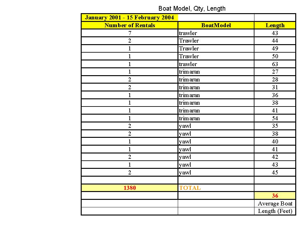
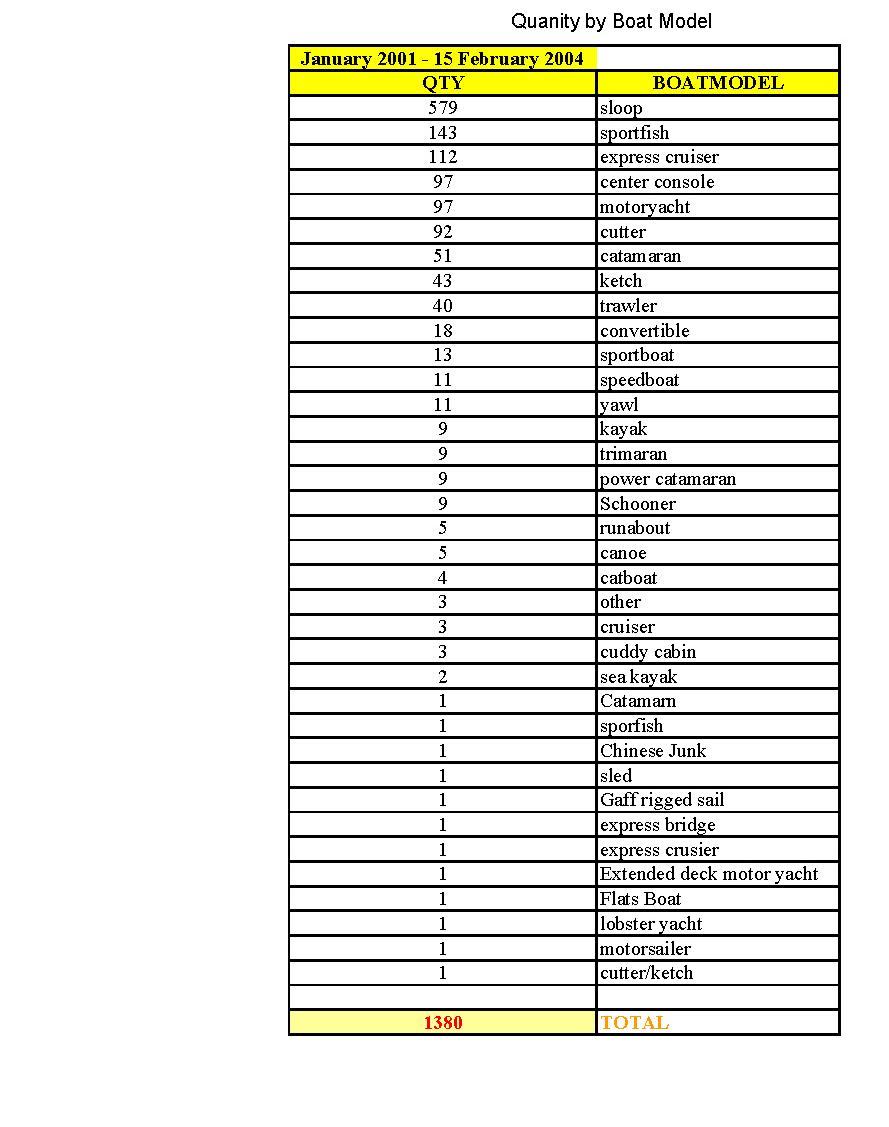
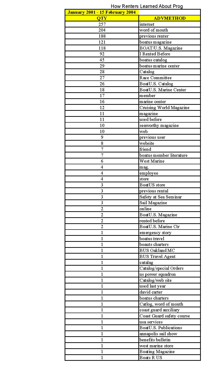
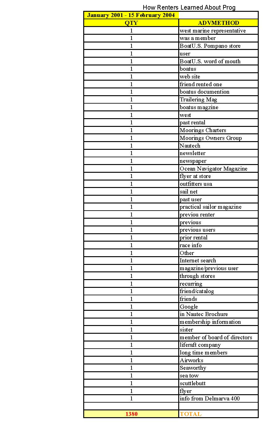
23 APPENDIX B: Current statistics on the following: rentals by State, rentals by boat model and length, and how renters heard about the EPIRB Rental Program 16
24 17
25 18
26 19
27 20
28 21
29 22
30 23
31 24
32 25
33 APPENDIX C: PRESS RELEASES: 406 MHz EPIRBs contributed to saving the lives of eight individuals in /28/2003 BOATU.S. RENTAL EPIRB ASSISTS IN RESCUE OF STRICKEN SAILING VESSEL OFF FLORIDA COAST March 28, A rented EPIRB (Emergency Position Indicating Radio Beacon) from the BoatU.S. Foundation for Boating Safety and Clean Water s EPIRB Rental Program contributed to the safe return early this morning of a 42 sailing vessel stricken with mechanical difficulties during gale-force weather off the Florida coast. With five aboard, the 42-foot sloop PatentColorado.com was 15 miles into a 42-mile Miami to Bimini crossing yesterday when a tornado-laden weather front struck the vessel. Forced to drop sail and start motoring, the vessel tossed in heavy seas killing the engine. Clogged fuel filters were suspected. Things went from bad to worse quickly, said BoatU.S. member and skipper, Rick Martin. With a change in wind direction, temperatures dropped 10 degrees, visibility went to zero in minutes, the seas turned nasty and three crew rapidly fell ill to seasickness, said Martin. Electrical problems also began to effect the boat. With no engine and an uncontrollable vessel in dangerous seas, Martin raised the U.S. Coast Guard on his VHF radio. When he was unable provide GPS coordinates, the Coast Guard asked him to activate the EPIRB. Activation allowed rescuers to easily locate the vessel and arrive on scene. It was later towed safely to harbor by a private tower. Back at the docks this morning, Martin commented, The BoatU.S. EPIRB helped save the day. The BoatU.S. Foundation makes these $900 life-saving devices available for $50 a week as a public service, said Ruth Wood, president of the BoatU.S. Foundation. The program is funded by the voluntary contributions of 535,000 members of BoatU.S. For more information, call or visit The mission of the Foundation is to promote safe and environmentally sensitive boating, reduce accidents and fatalities, and increase stewardship of our water resources. The Foundation also operates the only accredited, free, online boating safety course, a free Kids Life Jacket Loaner program, and awards grants to non-profit groups for boating safety and environmental projects. 5/27/2003 BOATU.S. FOUNDATION RENTAL EBIRB SAVES THREE OFF FLORIDA COAST A rented EPIRB (Emergency Position Indicating Radio Beacon) from the BoatU.S. Foundation for Boating Safety and Clean Water s EPIRB Rental Program helped save the lives of three sailors who were forced to abandon their sinking 30-foot sloop near Cape San Blas, FL on the evening of May 6. Just before midnight, a U.S. Coast Guard helicopter crew from Aviation Training Center Mobile, LA, picked up Fernando and Vickie Daleccio and their friend Gary Crayne after they reported that their vessel, Southern Breeze, was taking on water after striking an unknown object around 9:30 pm. The sloop s rudder had dislodged, leaving a gaping hole below the waterline that could not be closed. At 10:45 pm, as the vessel slid beneath the waves, the life-jacketed three abandoned ship, gathered around the rental EPIRB and held onto each other tightly in an effort to reduce hypothermia. Water intrusion quickly rendered the trio s only other communications device, a handheld VHF, inoperative. The EPIRB s activation led to a phone call by the Coast Guard to the BoatU.S. 24-hour Dispatch Center, which identified the Southern Breeze. Due to low visibility, Coast Guard rescuers had to use night-vision goggles to locate the sailors. Helicopter pilot Lt. Tom Meyer said, The [boaters] use of safety equipment was a huge factor in us finding them. 26
34 The Daleccio s go further. In a note to BoatU.S. along with the returned EPIRB, they commented, This [EPIRB] might have been the item that s solely responsible for saving our lives after we left our boat. The BoatU.S. Foundation makes these $900 life-saving devices available for $50 a week as a public service, said Ruth Wood, president of the BoatU.S. Foundation. The program is funded by the voluntary contributions of 535,000 members of BoatU.S. For more information, call or visit The mission of the Foundation is to promote safe and environmentally sensitive boating, reduce accidents and fatalities, and increase stewardship of our water resources. The Foundation also operates the only accredited, free, online boating safety course, a free Kids Life Jacket Loaner Program, and awards grants to non-profit groups for boating safety and environmental projects. 27

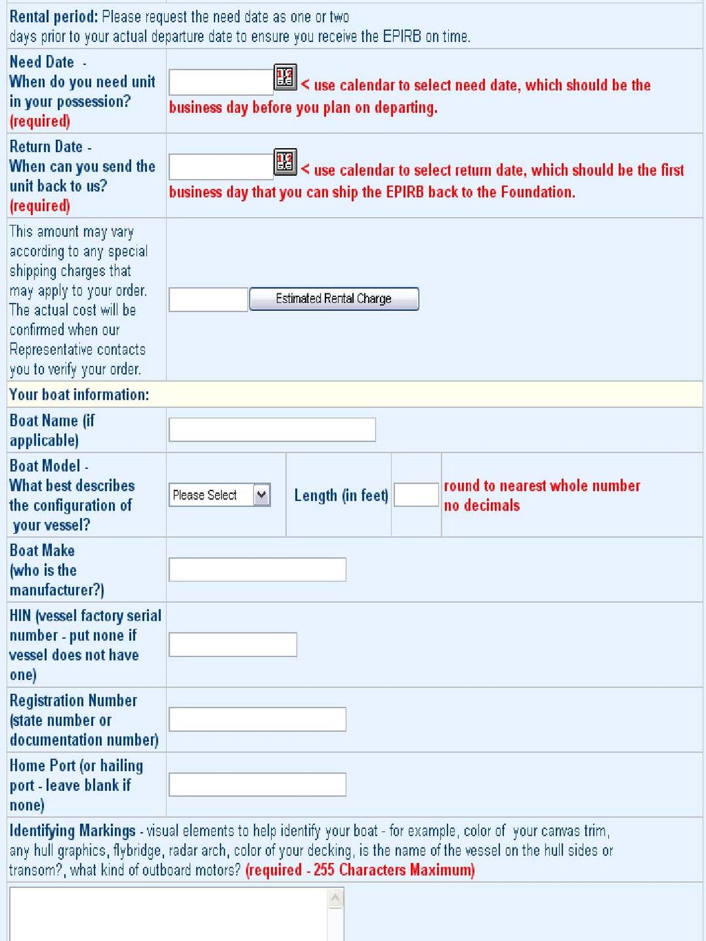
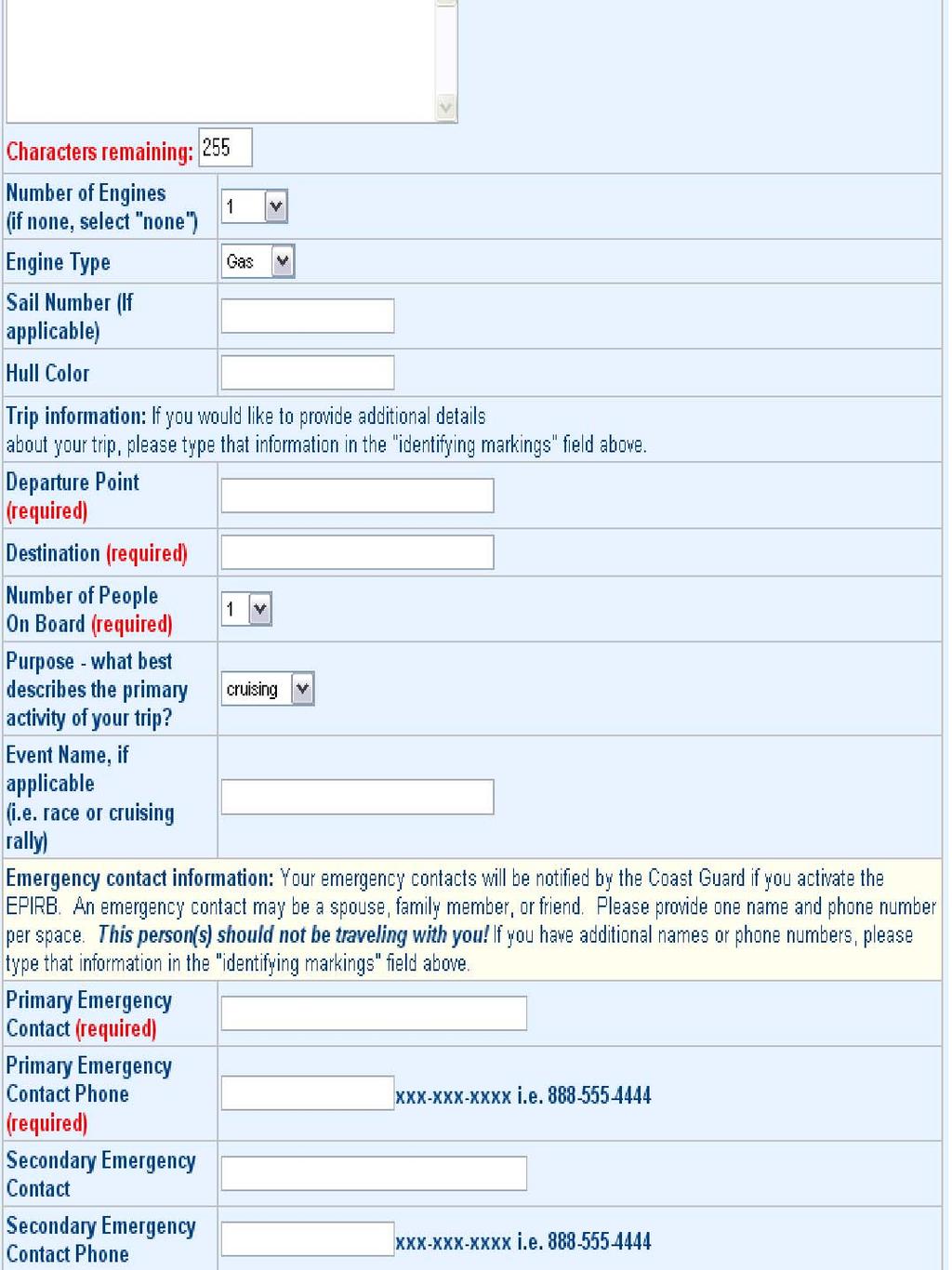
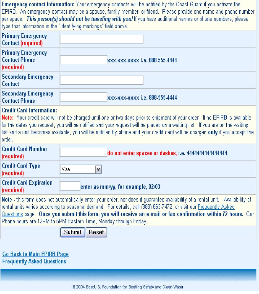
35 APPENDIX D: EPIRB Rental Program Online Order Form 28
36 29
37 30
38 31
GMDSS for Recreational Boaters
 GMDSS for Recreational Boaters OVERVIEW The Global Maritime Distress and Safety System (GMDSS) is an international system using advanced communications technology. Development of GMDSS was initiated by
The Future in Marine Radio Communication GMDSS. Department of Transportation United States Coast Guard
 The Future in Marine Radio Communication GMDSS Department of Transportation United States Coast Guard Do you use a Maritime Radio System? If so, the new Global Maritime Distress and Safety System (GMDSS)
FOR MORE INFORMATION ON GMDSS CONTACT:
 FOR MORE INFORMATION ON GMDSS CONTACT: Commanding Officer USCG Navigation Center, MS 7310, 7323 Telegraph Road, Alexandria, VA 20598-7310 Tel:1-703-313-5900 www.navcen.uscg.gov Commandant (CG-652) Spectrum
Global Maritime Distress and Safety System (GMDSS)
") Global Maritime Distress and Safety System (GMDSS) Global Maritime Distress and Safety System (GMDSS) BACKGROUNG, APPLICATION, DEFINITION GMDSS (Background) SOLAS 74 Ships 1600 TRG Radio Installation Ships
Global Maritime Distress and Safety System (GMDSS) Global Maritime Distress and Safety System (GMDSS) BACKGROUNG, APPLICATION, DEFINITION GMDSS (Background) SOLAS 74 Ships 1600 TRG Radio Installation Ships
ATTACHMENT E. How to Conduct a GMDSS Inspection.
 Page 1 of 7 NOTE: This document is an excerpt from The Report and Order In the Matter of Amendment of the Commission's Rules Concerning the Inspection of Radio Installations on Large Cargo and Small Passenger
Emergency Marine Communications
 Emergency Marine Communications Presented by: Steve Chamberlin Content:Chuck Hawley Safety at Sea Seminar US Sailing Goals of Emergency Communications To alert rescue services to your situation To get
Agenda. Importance of SARSAT Cospas-Sarsat System Description. U.S. SARSAT SARSAT Challenges
 SARSAT Overview SAR Controllers Training 2016 February 29 - March 3, 2016 Christopher O Connors NOAA Direct Services Branch Chief/SARSAT Program Manager Agenda Importance of SARSAT Cospas-Sarsat System
SARSAT Overview. SAR Controllers Training March2013. Jesse Reich NOAA Ground Systems Engineer
 SARSAT Overview SAR Controllers Training 2013 19 21 March2013 Jesse Reich NOAA Ground Systems Engineer Agenda Cospas-Sarsat Overview U.S. SARSAT Organization System Description User Segment (Beacons) /
An Introduction to INDUSTRY PARTNERS 25/05/2017. Military Army & Air Force. Government Defense & Rescue. Aviation Maritime Military. Other.
 An Introduction to 1 INDUSTRY PARTNERS Aviation Maritime Military Coast Guard & Navy Military Army & Air Force Government Defense & Rescue Other Commercial Commercial/Workboat Navy Air Force SAR Agencies
SUMMARY: The Coast Guard is declaring Sea Area A1 in certain. areas off the coast of the United States based upon the
 DEPARTMENT OF HOMELAND SECURITY Coast Guard [Docket No. USCG-2015-0002] Declaration of Sea Area A1 ACTION: Notice. This document is scheduled to be published in the Federal Register on 01/20/2015 and available
Communication & Safety at Sea
 Communication & Safety at Sea English Introducing Ocean Signal Ocean Signal specialises in the development and manufacture of advanced communication and safety products for the marine market. With one
Chapter 2. Search and Rescue Systems
 Chapter 2 Search and Rescue Systems Objectives (1 of 4) As they relate to SAR in the United States, describe the general roles of: National SAR Committee (NSARC) National SAR Plan National SAR Supplement
The transponder and emergency locator transmitter
 nuts & bolts building basics The ELT Past and Future ELT changes aim to improve safety GEORGE R. WILHELMSEN The transponder and emergency locator transmitter (ELT) are two pieces of avionics in the average
Communication & Safety at Sea
 Ocean Signal Ltd. Unit 4, Ocivan Way Margate CT9 4NN United Kingdom info@oceansignal.com +44 1843 282930 Communication & Safety at Sea Introducing Ocean Signal The Range Ocean Signal specialises in the
SARSAT Overview. SAR Controllers Training March 2015 Christopher O Connors NOAA SARSAT Program Manager
 SARSAT Overview SAR Controllers Training 2015 3 5 March 2015 Christopher O Connors NOAA SARSAT Program Manager Agenda Cospas-Sarsat System Description User Segment (Beacons) Space Segment Ground Segment
BookletChart. Sacramento River Sacramento to Fourmile Bend NOAA Chart A reduced-scale NOAA nautical chart for small boaters
 BookletChart Sacramento River Sacramento to Fourmile Bend NOAA Chart 18664 A reduced-scale NOAA nautical chart for small boaters When possible, use the full-size NOAA chart for navigation. Included Area
SAFETY EQUIPMENT AND PREPARATION. S/V Odette USA 5619
 SAFETY EQUIPMENT AND PREPARATION S/V Odette USA 5619 Odette5619@gmail.com COMMUNICATION PREPARATION Dedicate dock time for crew to familiarize themselves with all communication equipment: VHF: Walk through
At the heart of sea, air and land rescues
 At the heart of sea, air and land rescues 24 7 00:43 01:25 12:55 15:32 19:05 NEW ZEALAND w What we do Co-ordinate major maritime, aviation and land-based search and rescue operations (SAROPs) in New Zealand.
GUIDANCE ON THE COSPAS-SARSAT INTERNATIONAL 406 MHz BEACON REGISTRATION DATABASE
 E ALBERT EMBANKMENT LONDON SE1 7SR Telephone: +44 (0)20 7735 7611 Fax: +44 (0)20 7587 3210 GUIDANCE ON THE COSPAS-SARSAT INTERNATIONAL 406 MHz BEACON REGISTRATION DATABASE MSC.1/Circ.1210/Rev.1 21 November
GMDSS communication systems
 GMDSS Basic Concepts A System Overview Functional requirements The GMDSS (Global Maritime Distress and Safety System) is specifically designed to automate a ship's radio distress alerting function, and,
BookletChart. Sacramento River Andrus Island to Sacramento NOAA Chart A reduced-scale NOAA nautical chart for small boaters
 BookletChart Sacramento River Andrus Island to Sacramento NOAA Chart 18662 A reduced-scale NOAA nautical chart for small boaters When possible, use the full-size NOAA chart for navigation. Included Area
BookletChart. Intracoastal Waterway Grassy Key to Bahia Honda Key NOAA Chart A reduced-scale NOAA nautical chart for small boaters
 BookletChart Intracoastal Waterway Grassy Key to Bahia Honda Key NOAA Chart 11453 A reduced-scale NOAA nautical chart for small boaters When possible, use the full-size NOAA chart for navigation. Published
VHF FACT SHEET. Marine Very High Frequency (VHF) radio for recreational boaties. 1. Get the right VHF waterproof radio for your boating activity
 radio for recreational boaties. 1. Get the right VHF waterproof radio for your boating activity") VHF FACT SHEET Marine Very High Frequency (VHF) radio for recreational boaties Four simple steps for marine VHF radio 1. Get the right VHF waterproof radio for your boating activity 2. Complete a Maritime
VHF FACT SHEET Marine Very High Frequency (VHF) radio for recreational boaties Four simple steps for marine VHF radio 1. Get the right VHF waterproof radio for your boating activity 2. Complete a Maritime
SAFELINK EPIRB (WITH GPS) 406 Beacon Specification. Meets the requirements of international standards:
 406 Beacon Specification. Meets the requirements of international standards:") SAFELINK EPIRB (WITH GPS) 406 Beacon Specification Meets the requirements of international standards: IEC 61097 2 2008, IEC/EN 60945 Fourth edition (2002 08), ETSI 300 066 v1.3.1 (2001 01), RTCM SC110
SAFELINK EPIRB (WITH GPS) 406 Beacon Specification Meets the requirements of international standards: IEC 61097 2 2008, IEC/EN 60945 Fourth edition (2002 08), ETSI 300 066 v1.3.1 (2001 01), RTCM SC110
Cooperation Agreements for SAR Service and COSPAS-SARSAT
 SAR/NAM/CAR/SAM IP/15 International Civil Aviation Organization 07/05/09 Search and Rescue (SAR) Meeting for the North American, Caribbean and South American Regions (SAR/NAM/CAR/SAM) (Puntarenas, Costa
1
 12/20/2016 www.made-simplefor-cruisers.com 1 Emergency Position Indicating Radio Beacons (EPIRB) Only 406.0-406.1 EPIRBs with a built in GPS will be authorized for sale in the US. EPIRBs without position
RULES FOR THE CONSTRUCTION AND CLASSIFICATION OF MOBILE OFFSHORE DRILLING UNITS TITLE MOBILE OFFSHORE DRILLING UNITS NAUTIC AND ELECTRONICS CHAPTERS
 PARTE II RULES FOR THE CONSTRUCTION AND CLASSIFICATION OF MOBILE OFFSHORE DRILLING UNITS TITLE MOBILE OFFSHORE DRILLING UNITS SECTION 8 NAUTIC AND ELECTRONICS CHAPTERS A B C D SCOPE TECHNICAL DOCUMENTATION
MARITIME RADIO SYSTEMS FOR DISTRESS ALERTING
 Journal of KONES Powertrain and Transport, Vol. 25, No. 1 2018 MARITIME RADIO SYSTEMS FOR DISTRESS ALERTING Karol Korcz Gdynia Maritime University Department of Marine Telecommunication Morska Street 81-87,
L AGENCE NATIONALE DES FREQUENCES (ANFR) From Titanic to satellite from Morse to digital Entry in a new era for the maritime community
 From Titanic to satellite from Morse to digital Entry in a new era for the maritime community") L AGENCE NATIONALE DES FREQUENCES (ANFR) From Titanic to satellite from Morse to digital Entry in a new era for the maritime community ITU regional seminar 6-8 June 2018 St-Petersburg, Russian Federation
L AGENCE NATIONALE DES FREQUENCES (ANFR) From Titanic to satellite from Morse to digital Entry in a new era for the maritime community ITU regional seminar 6-8 June 2018 St-Petersburg, Russian Federation
WRITTEN TEST Certificate for the operation of maritime VHF radio systems (SRC)
") WRITTEN TEST Certificate for the operation of maritime VHF radio systems (SRC) Place: Valby 1 Date: 20 April 2016 Name: Personal ID no.: Permitted aids: Radio stations in ships appendix. 1 TABLE OF ANSWERS
WRITTEN TEST Certificate for the operation of maritime VHF radio systems (SRC) Place: Valby 1 Date: 20 April 2016 Name: Personal ID no.: Permitted aids: Radio stations in ships appendix. 1 TABLE OF ANSWERS
BookletChart. Chesapeake Bay Pocomoke and Tangier Sounds NOAA Chart A reduced-scale NOAA nautical chart for small boaters
 BookletChart Chesapeake Bay Pocomoke and Tangier Sounds NOAA Chart 12228 A reduced-scale NOAA nautical chart for small boaters When possible, use the full-size NOAA chart for navigation. Published by the
Extent of Consultation
 Objective Parts 40A, 40C and 40D prescribe design, construction and equipment requirements for passenger ships that are not SOLAS ships, non-passenger ships that are not SOLAS ships and fishing ships.
Digital Selective Calling (DSC) Radios
 Radios") Digital Selective Calling (DSC) Radios The Global Maritime Distress Safety System (GMDSS) DSC radios are an integral part of the Global Maritime Distress Safety System (GMDSS), which is an internationally
Digital Selective Calling (DSC) Radios The Global Maritime Distress Safety System (GMDSS) DSC radios are an integral part of the Global Maritime Distress Safety System (GMDSS), which is an internationally
PROSECUTING 406/121.5 MHZ DISTRESS BEACONS. Table of Contents
 PROSECUTING 406/121.5 MHZ DISTRESS BEACONS Table of Contents 1. Purpose and intended recipients of this document 2. Synopsis 3. 406 MHz Distress Beacon Channels and Radio Frequency Spectrum 4. Limitations
MEOSAR Performance Overview. SAR Controllers Training March 2016 Mickey Fitzmaurice NOAA Senior Systems Engineer
 MEOSAR Performance Overview SAR Controllers Training 2016 1 3 March 2016 Mickey Fitzmaurice NOAA Senior Systems Engineer MEOSAR: AN IMPROVED SYSTEM CONCEPT MEO sat at 20,000 km LEO sat at 800-900 km MEO
RESOLUTION A.659(16) adopted on 19 October 1989 PROVISION OF RADIO SERVICES FOR THE GLOBAL MARITIME DISTRESS AND SAFETY SYSTEM
 adopted on 19 October 1989 PROVISION OF RADIO SERVICES FOR THE GLOBAL MARITIME DISTRESS AND SAFETY SYSTEM") INTERNATIONAL MARITIME ORGANIZATION RESOLUTION A.659(16) adopted on 19 October 1989 A 16/Res.659 30 November 1989 Original: ENGLISH ASSEMBLY - 16th session Agenda item 10 IMO RESOLUTION A.659(16) adopted
INTERNATIONAL MARITIME ORGANIZATION RESOLUTION A.659(16) adopted on 19 October 1989 A 16/Res.659 30 November 1989 Original: ENGLISH ASSEMBLY - 16th session Agenda item 10 IMO RESOLUTION A.659(16) adopted
Standard Operating Procedures for: VHF Marine Radio
 Serenity Houseboat I. Overview Standard Operating Procedures for: VHF Marine Radio VHF, or Very High Frequency, marine radio is the standard method of communication between vessels. Marine radio equipment
Status of the COSPAS-SARSAT system and future development integrated in GALILEO. Patrice Brault MARTEC SERPE-IESM
 Status of the COSPAS-SARSAT system and future development integrated in GALILEO Patrice Brault MARTEC SERPE-IESM MARTEC SERPE IESM plant Guidel ARGOS drifter PTR ERIKA Safety of human life actual components
REVISED QUESTIONNAIRE ON SHORE-BASED FACILITIES FOR THE GLOBAL MARITIME DISTRESS AND SAFETY SYSTEM (GMDSS)
") E 4 ALBERT EMBANKMENT LONDON SE1 7SR Telephone: +44 (0)20 7735 7611 Fax: +44 (0)20 7587 3210 MSC.1/Circ.1382/Rev.2 24 June 2013 REVISED QUESTIONNAIRE ON SHORE-BASED FACILITIES FOR THE GLOBAL MARITIME DISTRESS
E 4 ALBERT EMBANKMENT LONDON SE1 7SR Telephone: +44 (0)20 7735 7611 Fax: +44 (0)20 7587 3210 MSC.1/Circ.1382/Rev.2 24 June 2013 REVISED QUESTIONNAIRE ON SHORE-BASED FACILITIES FOR THE GLOBAL MARITIME DISTRESS
IMO GUIDELINES TO ADMINISTRATIONS ON REPORTING FALSE ALERTS
 INTERNATIONAL MARITIME ORGANIZATION 4 ALBERT EMBANKMENT LONDON SE1 7SR Telephone: 020 7735 7611 Fax: 020 7587 3210 Telex: 23588 IMOLDN G IMO E Ref. T2/6.04 MSC/Circ.1078 6 June 2003 GUIDELINES TO ADMINISTRATIONS
Seychelles Civil Aviation Authority SAFETY NOTICE. Coding and registration of Seychelles 406 Mhz Emergency Locator Transmitters (ELTs)
") Seychelles Civil Aviation Authority Safety Notice SAFETY NOTICE Number: Issued: 25 April 2018 Coding and registration of Seychelles 406 Mhz Emergency Locator Transmitters (ELTs) This Safety Notice contains
Seychelles Civil Aviation Authority Safety Notice SAFETY NOTICE Number: Issued: 25 April 2018 Coding and registration of Seychelles 406 Mhz Emergency Locator Transmitters (ELTs) This Safety Notice contains
White paper March UrgentLink DISASTER COMMUNICATIONS NETWORK
 White paper March 2018 UrgentLink DISASTER COMMUNICATIONS NETWORK Background Tragedies such as September 11, Hurricane Katrina and more recently Hurricane Harvey, Hurricane Maria, and the California wildfires
Trusted for Life TM. USCG AIS Mandate. 3 rd December 10:30 am - 11:15 am
 Trusted for Life TM USCG AIS Mandate 3 rd December 10:30 am - 11:15 am The AIS Mandate McMurdo Stand 2335 CEO McMurdo UK McMurdo By the Numbers 25% Percentage of world s 406MHz beacons manufactured by
American Marine Training Center, LLC AMTC (2682)
") American Marine Training Center, LLC www.americanmarinetc.com 1-855-344-AMTC (2682) (This is the FCC Commercial Element 7R Question Pool. It has been edited to make it more user friendly to assist as a
American Marine Training Center, LLC www.americanmarinetc.com 1-855-344-AMTC (2682) (This is the FCC Commercial Element 7R Question Pool. It has been edited to make it more user friendly to assist as a
GOAL: Students will be able to identify what constitutes an effective signal and use signals in an emergency situation.
 CHAPTER 4 SIGNALS Time: One-half hour GOAL: Students will be able to identify what constitutes an effective signal and use signals in an emergency situation. NEED STATEMENT: 1.To be a survivor you must
QUESTIONNAIRE ON SHORE-BASED FACILITIES FOR THE GLOBAL MARITIME DISTRESS AND SAFETY SYSTEM (GMDSS)
") E 4 ALBERT EMBANKMENT LONDON SE1 7SR Telephone: +44 (0)20 7735 7611 Fax: +44 (0)20 7587 3210 Ref. T2-OSS/2.6 MSC.1/Circ.1382 3 December 2010 QUESTIONNAIRE ON SHORE-BASED FACILITIES FOR THE GLOBAL MARITIME
E 4 ALBERT EMBANKMENT LONDON SE1 7SR Telephone: +44 (0)20 7735 7611 Fax: +44 (0)20 7587 3210 Ref. T2-OSS/2.6 MSC.1/Circ.1382 3 December 2010 QUESTIONNAIRE ON SHORE-BASED FACILITIES FOR THE GLOBAL MARITIME
OPERATIONS SEAFARER CERTIFICATION GUIDANCE NOTE SA MARITIME QUALIFICATIONS CODE SHORT RANGE CERTIFICATE (SRC)
") Page 1 of 8 Compiled by Chief Examiner Approved by Senior Radio Examiner OPERATIONS SEAFARER CERTIFICATION GUIDANCE NOTE SA MARITIME QUALIFICATIONS CODE SHORT Page 2 of 8 SHORT : OUTLINE EXAMINATION SYLLABUS
Page 1 of 8 Compiled by Chief Examiner Approved by Senior Radio Examiner OPERATIONS SEAFARER CERTIFICATION GUIDANCE NOTE SA MARITIME QUALIFICATIONS CODE SHORT Page 2 of 8 SHORT : OUTLINE EXAMINATION SYLLABUS
Capt. MOHAMED ASHOUR
 1 What is signaling techniques? Signaling techniques is the art to use signaling devices for saving lives 2 Communication One of your first concerns when you find yourself in a survival situation is to
ARTICLE 32 Operational procedures for distress communications in the global maritime distress and safety system (GMDSS) (WRC-07) Section I _ General
 (WRC-07) Section I _ General") ARTICLE 32 Operational procedures for distress communications in the global maritime distress and safety system (GMDSS) (WRC-07) Section I _ General 32.1 1 Distress communications rely on the use of terrestrial
ARTICLE 32 Operational procedures for distress communications in the global maritime distress and safety system (GMDSS) (WRC-07) Section I _ General 32.1 1 Distress communications rely on the use of terrestrial
there is a description of the vessel, you will substitute the prop description of your boat. VHF Booklet
 VHF Booklet Imagine what may happen if a distress situation were to take place and you or a guest on your boat needed to place some form of priority call. In the excitement of the moment, it is easy to
AIC AERONAUTICAL INFORMATION SERVICE OFFICE OF CIVIL AVIATION P. O. BOX 684, BOROKO
 PAPUA NEW GUINEA AIC TELEPHONE 3244672 TELEGRAPHIC ADDRESS AFTN AYPYYOYX Fax 3250749 File: 33.16.3 AERONAUTICAL INFORMATION SERVICE OFFICE OF CIVIL AVIATION P. O. BOX 684, BOROKO 01/2004 06 SEP 406 MHz
COMMUNICATION SYSTEMS FOR SAFETY AND SECURITY OF SHIPS
 Journal of KONES Powertrain and Transport, Vol. 23, No. 1 2016 COMMUNICATION SYSTEMS FOR SAFETY AND SECURITY OF SHIPS Karol Korcz Gdynia Maritime University, Department of Marine Telecommunication Morska
Radio Log Book. for Canadian Flag Vessels. 1 Master s Signature. Transports Canada. Transport Canada TP 13926E MARINE SAFETY
 Transport Canada MARINE SAFETY Transports Canada TP 13926E Radio Log Book for Canadian Flag Vessels Also for use on GMDSS exempted vessels Date Commenced Date Completed 1 Instructional Guide for Keeping
Systems. Contents 1 Rescue. 3 Operation. 2 Transmission. Objectives In this section students will...
 1 Systems Contents 1 Rescue Objectives In this section students will listen to a news report about an air-sea rescue read an incident report and complete an incident report form study and practise using
How to Conduct a Bridge to Bridge Inspection
 How to Conduct a Bridge to Bridge Inspection 80.1001 Applicability. The Bridge-to-Bridge Act and the regulations of this part apply to the following vessels in the navigable waters of the United States:
ICAO/IMO JOINT WORKING GROUP ON HARMONIZATION OF AERONAUTICAL AND MARITIME SEARCH AND RESCUE (ICAO/IMO JWG-SAR)
") International Civil Aviation Organization ICAO/IMO JWG-SAR/13-WP/3 30/6/06 WORKING PAPER ICAO/IMO JOINT WORKING GROUP ON HARMONIZATION OF AERONAUTICAL AND MARITIME SEARCH AND RESCUE (ICAO/IMO JWG-SAR)
International Civil Aviation Organization ICAO/IMO JWG-SAR/13-WP/3 30/6/06 WORKING PAPER ICAO/IMO JOINT WORKING GROUP ON HARMONIZATION OF AERONAUTICAL AND MARITIME SEARCH AND RESCUE (ICAO/IMO JWG-SAR)
The Alaska Air Carriers Association. Supports and Advocates for the Commercial Aviation Community
 The Alaska Air Carriers Association Supports and Advocates for the Commercial Aviation Community The Alaska Air Carriers Association membership includes Part 121, 135, 125 and commercial Part 91 air operators.
Digital Selective Calling. Safety at Sea for the 21 st Century
 Digital Selective Calling Safety at Sea for the 21 st Century Search and Rescue VHF-FM Marine-band radios are the safest method to notify the Coast Guard of a maritime distress. The Coast Guard will continuously
This circular summarizes the various important aspects of the LRIT system with a view to enabling companies to ensure compliance in a timely manner.
 Luxembourg, 29/10/2008 CIRCULAR CAM 02/2008 N/Réf. : AH/63353 Subject : Long-Range Identification and Tracking of Ships (LRIT) To : All ship owners, ship operators and designated persons of Luxembourg
MINIMIZING DELAYS IN SEARCH AND RESCUE RESPONSE TO DISTRESS ALERTS
 INTERNATIONAL MARITIME ORGANIZATION 4 ALBERT EMBANKMENT LONDON SE1 7SR Telephone: 020 7735 7611 Fax: 020 7587 3210 IMO E Ref. T2-OSS/1.4 MSC.1/Circ.1248 16 October 2007 MINIMIZING DELAYS IN SEARCH AND
SAN DIEGO COUNTY MUTUAL AID RADIO PLAN
 ATTACHMENT A SAN DIEGO COUNTY MUTUAL AID RADIO PLAN 1.1 General Mutual aid channels are a critical part of San Diego County's radio system requirements. The San Diego County Mutual Aid Radio Plan will
Circular. Notice of Requirement for Medical Oxygen Cylinder and EPRIB
 CCS Circular To: CCS surveyors, Auditors, Marshall Islands Ship owners and Ship managers, Radio inspection company China Classification Society (2011)Circ. No.21 Total No.85 Apr. 21, 2011 (Total pages:
BookletChart. St. Joseph and Benton Harbor NOAA Chart A reduced-scale NOAA nautical chart for small boaters
 BookletChart St. Joseph and Benton Harbor NOAA Chart 14930 A reduced-scale NOAA nautical chart for small boaters When possible, use the full-size NOAA chart for navigation. Included Area Published by the
MEMORANDUM NO MAY Directives Affected. Reference (a) is temporarily augmented by this policy letter.
 is temporarily augmented by this policy letter.") U.S. Department of Commandant 2100 Second Street, S.W. Homeland Security United States Coast Guard Washington, DC 20593-0001 Staff Symbol: -1 Phone: (202) 267-2735 United States Fax: (202) 267-4394 Coast
U.S. Department of Commandant 2100 Second Street, S.W. Homeland Security United States Coast Guard Washington, DC 20593-0001 Staff Symbol: -1 Phone: (202) 267-2735 United States Fax: (202) 267-4394 Coast
ICAO Inter-regional SAR Workshop 2016
 ICAO Inter-regional SAR Workshop 2016 Global Aeronautical Distress and Safety System (GADSS) - Implications for Search And Rescue Services Dave Edwards U.S. Coast Guard Chairman, International Civil Aviation
Ref: CS05/320/F December 2005
 Ref: CS05/320/F510-511-530-480 20 December 2005 To: 406 MHz Beacon Manufacturers, Agents & Developers, C-S Beacon Type Approval Test Facilities, Beacon Component Manufacturers, Cc: International Civil
RESOLUTION MSC.278(85) (adopted on 1 December 2008) ADOPTION OF THE NEW MANDATORY SHIP REPORTING SYSTEM "OFF THE COAST OF PORTUGAL - COPREP"
 (adopted on 1 December 2008) ADOPTION OF THE NEW MANDATORY SHIP REPORTING SYSTEM OFF THE COAST OF PORTUGAL - COPREP") MSC 85/26/Add.1 RESOLUTION MSC.278(85) SYSTEM OFF THE COAST OF PORTUGAL COPREP THE MARITIME SAFETY COMMITTEE, RECALLING Article 28 of the Convention on the International Maritime Organization concerning
MSC 85/26/Add.1 RESOLUTION MSC.278(85) SYSTEM OFF THE COAST OF PORTUGAL COPREP THE MARITIME SAFETY COMMITTEE, RECALLING Article 28 of the Convention on the International Maritime Organization concerning
GMDSS modernisation and e-navigation: spectrum needs
 ETSI Workshop "Future Evolution of Marine Communication", 7-8 November 2017, Sophia Antipolis, France GMDSS modernisation and e-navigation: spectrum needs Karlis Bogens BR Terrestrial Services Department
Agenda Item 3: Performance framework for Regional Air Navigation Planning and Implementation BRAZILIAN AERONAUTICAL SEARCH AND RESCUE SYSTEM
 GREPECAS/16-IP/13 International Civil Aviation Organization 03/03/11 CAR/SAM Regional Planning and Implementation Group (GREPECAS) Sixteenth Meeting of the CAR/SAM Regional Planning and Implementation
PRODUCTS AND SERVICES FOR THE MARITIME COMMUNITY. Ed Martin, Chief Customer Affairs Branch Navigation Services Division Monday, 27 October, 2008
 PRODUCTS AND SERVICES FOR THE MARITIME COMMUNITY Ed Martin, Chief Customer Affairs Branch Navigation Services Division Monday, 27 October, 2008 Coral Reef Conservation International Collaboration Marine
RECOMMENDATION ITU-R M.541-8*
 Rec. ITU-R M.541-8 1 RECOMMENDATION ITU-R M.541-8* OPERATIONAL PROCEDURES FOR THE USE OF DIGITAL SELECTIVE-CALLING EQUIPMENT IN THE MARITIME MOBILE SERVICE (Question ITU-R 9/8) (1978-1982-1986-1990-1992-1994-1995-1996-1997)
Universidad Nacional Experimental Marítima del Caribe Vicerrectorado Académico Cátedra de Idiomas Inglés VI. Ingeniería Marítima
 Universidad Nacional Experimental Marítima del Caribe Vicerrectorado Académico Cátedra de Idiomas Inglés VI. Ingeniería Marítima UNIT II. Navigational equipment found onboard ships. Speaking. 1. Can you
What are the GMDSS requirements?
 What are the GMDSS requirements? Minimum requirements GMDSS ships are required to carry the following minimum equipment: A VHF radio installation capable of transmitting DSC on channel 70, and radiotelephony
MARITIME AND ENERGY PRODUCT CATALOGUE NOVEMBER
 MARITIME AND ENERGY PRODUCT CATALOGUE NOVEMBER 2018 www.jotron.com Introduction Jotron offers an extensive and flexible range of safety products within GMDSS, AIS and lights. The Jotron GMDSS product
Passages Between Acklins Island, Haiti and Caicos Islands NGA Chart A reduced-scale NGA nautical chart for small boaters
 BookletChart Passages Between Acklins Island, Haiti and Caicos Islands NGA Chart 26260 A reduced-scale NGA nautical chart for small boaters When possible, use the full-size NGA chart or Electronic Nautical
Applications of Satellite-AIS (S-AIS) for Search and Rescue
 for Search and Rescue") Business White Paper Applications of Satellite-AIS (S-AIS) for Search and Rescue Executive Summary Automatic Identification System (AIS) is a mandatory 1 navigation safety communications system under the
Business White Paper Applications of Satellite-AIS (S-AIS) for Search and Rescue Executive Summary Automatic Identification System (AIS) is a mandatory 1 navigation safety communications system under the
GMDSS RADIO INSTALLATION
 Ship s name: N.R. Survey: GMDSS RADIO INSTALLATION (Res. A.1053(27)) INITIAL (Newconstruction) PERIODICAL RENEWAL Sea areas: A1 Methods of maintenance: Duplication of (Reg. IV/12-15) A1+A2 (Reg. IV/15)
National Data Distribution. SAR Controllers Training March 2016 Dawn D. Anderson ERT, Inc. Chief USMCC
 National Data Distribution SAR Controllers Training 2016 1 3 March 2016 Dawn D. Anderson ERT, Inc. Chief USMCC Overview Data Distribution for the C/S System MEOSAR Data Principles of National Data Distribution
Sub-regional SAR Systems. Brian Day General Civil Aviation Authority United Arab Emirates ICAO Global SAR Forum Abu Dhabi 2010
 Sub-regional SAR Systems Brian Day General Civil Aviation Authority United Arab Emirates ICAO Global SAR Forum Abu Dhabi 2010 LEGAL OBLIGATION Article 25 of Chicago Convention Each Contracting State undertakes
Did you know that prior to late 1912, there were no laws or regulations restricting amateur radio transmitters in the United States?
 Do You Know? Did you know that prior to late 1912, there were no laws or regulations restricting amateur radio transmitters in the United States? The Radio Act of 1912 (37 Stat. 302) is the United States
Annex 11 to Working Party 5B Chairman s Report WORKING DOCUMENT TOWARDS A PRELIMINARY DRAFT NEW REPORT ITU-R M.[SNAP]
![Annex 11 to Working Party 5B Chairman s Report WORKING DOCUMENT TOWARDS A PRELIMINARY DRAFT NEW REPORT ITU-R M.[SNAP]](/thumbs/92/108810182.jpg "Annex 11 to Working Party 5B Chairman s Report WORKING DOCUMENT TOWARDS A PRELIMINARY DRAFT NEW REPORT ITU-R M.[SNAP]") Radiocommunication Study Groups Source: Document 5B/TEMP/287 Annex 11 to Document 5B/617-E 29 November 2010 English only Annex 11 to Working Party 5B Chairman s Report WORKING DOCUMENT TOWARDS A PRELIMINARY
Radiocommunication Study Groups Source: Document 5B/TEMP/287 Annex 11 to Document 5B/617-E 29 November 2010 English only Annex 11 to Working Party 5B Chairman s Report WORKING DOCUMENT TOWARDS A PRELIMINARY
RECOMMENDATION ITU-R M * Technical characteristics for search and rescue radar transponders
 Rec. ITU-R M.628-4 1 RECOMMENDATION ITU-R M.628-4 * Technical characteristics for search and rescue radar transponders (Questions ITU-R 28/8 and ITU-R 45/8) (1986-1990-1992-1994-2006) Scope This Recommendation
MARINE RADIO IN A NUTSHELLv5 CONTENTS
 MARINE RADIO IN A NUTSHELLv5 GENERAL CONTENTS USE OF SHIP RADIO STATIONS SILENCE PERIODS MARITIME COMMUNICATION STATIONS AMSA STATIONS (COAST RADIO NETWORK) LIMITED COAST STATIONS (RVCP, AVCG, VMR, ETC)
Table of Contents. Quick Start Guide. Important Notes! Nautilus GPS Components. Operation. Region Programming & MMSI. Nautilus GPS App.
 Table of Contents 03 04 05 06 07 08 09 09 10 10 11 Quick Start Guide Important Notes! Nautilus GPS Components Operation Region Programming & MMSI Nautilus GPS App Test Sequence Maintenance Battery Information
Personal Radio Services
 Tonight s training is titled (Nov. 5, 2009) Personal Radio Services Personal radio services provide short-range, low power radio for personal communications, radio signaling, and business communications
BookletChart. Port-au-Prince (Haiti) NGA Chart A reduced-scale NGA nautical chart for small boaters
 NGA Chart A reduced-scale NGA nautical chart for small boaters") BookletChart Port-au-Prince (Haiti) NGA Chart 26186 A reduced-scale NGA nautical chart for small boaters When possible, use the full-size NGA chart or Electronic Nautical Chart (ENC) for navigation. VHF
BookletChart Port-au-Prince (Haiti) NGA Chart 26186 A reduced-scale NGA nautical chart for small boaters When possible, use the full-size NGA chart or Electronic Nautical Chart (ENC) for navigation. VHF
BookletChart. Approaches to Cap-Haitien and Bahia de Monti Cristi NGA Chart A reduced-scale NGA nautical chart for small boaters
 BookletChart Approaches to Cap-Haitien and Bahia de Monti Cristi NGA Chart 26142 A reduced-scale NGA nautical chart for small boaters When possible, use the full-size NGA chart or Electronic Nautical Chart
Merchant Shipping Act 57 of 1951 section 356
 MADE IN TERMS OF section 356 Government Notice 105 of 2010 (GG 4486) came into force on date of publication: 18 May 2010 The Government Notice which issues these regulations repeals the Merchant Shipping
Baie de L Acul and Approaches (Haiti) NGA Chart A reduced-scale NGA nautical chart for small boaters
 NGA Chart A reduced-scale NGA nautical chart for small boaters") BookletChart Baie de L Acul and Approaches (Haiti) NGA Chart 26148 A reduced-scale NGA nautical chart for small boaters When possible, use the full-size NGA chart or Electronic Nautical Chart (ENC) for
BookletChart Baie de L Acul and Approaches (Haiti) NGA Chart 26148 A reduced-scale NGA nautical chart for small boaters When possible, use the full-size NGA chart or Electronic Nautical Chart (ENC) for
Problem. How we solve the problem.
 Humanitarian agencies need to trust their personnel are safe and secure at all times. A long range digital radio solution provides reliable voice and data communications for workers in the field, ensuring
Owner s Manual SAFETY SYSTEMS FOR MARITIME SURVIVABILITY & RESCUE
 Owner s Manual SAFETY SYSTEMS FOR MARITIME SURVIVABILITY & RESCUE 1 Introduction www.briartek.com BriarTek, Inc. Technical Support: 703.548.7892 Email: support@briartek.com 2010 BriarTek Incorporated.
RESOLUTION MSC.131(75) (adopted on 21 May 2002) MAINTENANCE OF A CONTINUOUS LISTENING WATCH ON VHF CHANNEL 16 BY SOLAS SHIPS WHILST AT SEA AFTER 1
 (adopted on 21 May 2002) MAINTENANCE OF A CONTINUOUS LISTENING WATCH ON VHF CHANNEL 16 BY SOLAS SHIPS WHILST AT SEA AFTER 1") MSC 75/24/Add.1 RESOLUTION MSC.131(75) (adopted on 21 May 2002) CHANNEL 16 BY SOLAS SHIPS WHILST AT SEA AFTER 1 FEBRUARY 1999 AND INSTALLATION OF VHF DSC FACILITIES ON THE MARITIME SAFETY COMMITTEE, RECALLING
MSC 75/24/Add.1 RESOLUTION MSC.131(75) (adopted on 21 May 2002) CHANNEL 16 BY SOLAS SHIPS WHILST AT SEA AFTER 1 FEBRUARY 1999 AND INSTALLATION OF VHF DSC FACILITIES ON THE MARITIME SAFETY COMMITTEE, RECALLING
FREQUENCIES FOR DISTRESS AND SAFETY, SEARCH AND RESCUE AND EMERGENCIES
 FREQUENCIES FOR DISTRESS AND SAFETY, SEARCH AND RESCUE AND EMERGENCIES Given the global nature of travel with the potential risk of accidents the international community has agreed that the use of certain
The Future of Search & Rescue. We Save Lives. Steve Waters SAFE Symposium 2016
 The Future of Search & Rescue We Save Lives Steve Waters SAFE Symposium 2016 Covering today.. Understanding the Search and Rescue Ecosystem Helios and GADSS Global Aeronautical Distress and Safety System
International Maritime Organization DRAFT IMO POSITION ON WRC-19 AGENDA ITEMS CONCERNING MATTERS RELATING TO MARITIME SERVICES
 2 nd ITU INTER-REGIONAL WORKSHOP ON WRC-19 PREPARATION Geneva, 20 22 November 2018 Document 12 November 2018 English only International Maritime Organization DRAFT IMO POSITION ON WRC-19 AGENDA ITEMS CONCERNING
NMEA2000- Par PGN. Mandatory Request, Command, or Acknowledge Group Function Receive/Transmit PGN's
 PGN Number Category Notes - Datum Local geodetic datum and datum offsets from a reference datum. T The Request / Command / Acknowledge Group type of 126208 - NMEA - Request function is defined by first
CEPT/ERC/RECOMMENDATION E (Bonn 1994)
") CEPT/ERC/RECOMMENDATION 31-05 E (Bonn 1994) Page 1 HARMONISED EXAMINATION PROCEDURES FOR MARITIME RADIO OPERATOR S CERTIFICATES APPROPRIATE TO VESSELS WHICH USE THE FREQUENCIES AND TECHNIQUES OF THE GLOBAL
CEPT/ERC/RECOMMENDATION 31-05 E (Bonn 1994) Page 1 HARMONISED EXAMINATION PROCEDURES FOR MARITIME RADIO OPERATOR S CERTIFICATES APPROPRIATE TO VESSELS WHICH USE THE FREQUENCIES AND TECHNIQUES OF THE GLOBAL
Satellite technology to prevent and respond in cases of maritime accidents
 United Nations International Conference on Space-based Technologies for Disaster Management "Disaster risk identification, assessment and monitoring" 23-25 October 2013, Beijing, China. Satellite technology
DRAFT ASSEMBLY RESOLUTION A. (26)
") DRAFT ASSEMBLY RESOLUTION A. (26) PROMULGATION OF MARITIME SAFETY INFORMATION The ASSEMBLY, RECALLING Article 15(j) of the Convention on the International Maritime Organization concerning the functions
DRAFT ASSEMBLY RESOLUTION A. (26) PROMULGATION OF MARITIME SAFETY INFORMATION The ASSEMBLY, RECALLING Article 15(j) of the Convention on the International Maritime Organization concerning the functions
National Marine Electronics Association International Marine Electronics Association. Technical Bulletin
 National Marine Electronics Association International Marine Electronics Association Technical Bulletin Amendment to NMEA 0183 Version 4.10 # AT 0183 20130815 NMEA 0183 Amendment An amendment is a technical