No APRIL 2012 UNITED STATES OF AMERICA. Contents
|
|
|
- Kelly Sabrina Norris
- 5 years ago
- Views:
Transcription


1 15 14 APRIL 2012 UNITED STATES OF AMERICA Published Weekly by the National Geospatial-Intelligence Agency Prepared Jointly with the National Ocean Service and U.S. Coast Guard Contents Section I Chart Corrections I-1.1 Chartlets / Depth Tabulations / Notes I-2.1 Charts Affected by Notice to Mariners I-3.1 Section II NGA/DLIS Catalog Corrections NONE Navigation Publications Corrections II-1.1 USCG Light List Corrections / Radiobeacon Corrections II-2.1 NGA List of Lights / Radiobeacon / DGPS Corrections II-3.1 Publications Affected by Notice to Mariners II-4.1 Section III Broadcast Warnings / MARAD Advisories / Special Warnings III-1.1 Marine Information III-2.1 Visit the Maritime Safety Web site at
2 IMPORTANT INFORMATION The Notice to Mariners is published by the National Geospatial-Intelligence Agency (NGA), under the authority of Department of Defense Directive , to advise mariners of important matters affecting navigational safety, including new hydrographic discoveries, changes in channels and navigational aids, etc. (U.S. Code Title 10, Sec. 442 and Title 44, Sec refer). Nothing in the arrangement of information implies endorsement or acceptance by NGA in matters affecting the status and boundaries of States and territories. The Notice to Mariners presents corrective information affecting charts, NGA/DLIS Catalog of Maps Charts and Related Products, Coast Pilots, USCG Light Lists, NGA List of Lights and other products produced by the National Geospatial-Intelligence Agency, National Ocean Service and U.S. Coast Guard. Information for the Notice to Mariners is contributed by the following Agencies: National Geospatial-Intelligence Agency (NGA) (Department of Defense) for waters outside the territorial limits of the United States; National Ocean Service (NOS) (Department of Commerce), which is charged with the surveys and charting of the coasts and harbors of the United States and its territories; the U.S. Coast Guard (USCG) (Department of Homeland Security), which is responsible for the safety of life at sea and the establishment and operation of aids to navigation; and the U.S. Army Corps of Engineers (Department of Defense), which is charged with the improvement of rivers and harbors of the United States. In addition, important contributions are made by foreign hydrographic offices and cooperating observers of all nationalities. For further information concerning NGA hydrographic products and services, including the Maritime Safety Web site, users may contact: Name Telephone DSN FAX Maritime Safety Office N/A World Wide Navigational Warning Service Maritime Safety Web site N/A Notice to Mariners: Regions 1 and Notice to Mariners: Regions 3 thru Sailing Directions, Fleet Guides Navigation Publications DLA Catalog of Maps Charts and Related Products The Maritime Safety Web site can be accessed directly at For your convenience NGA provides four addresses. For information affecting Notice to Mariners use MCDNtM@nga.mil, for information affecting Sailing Directions and all other navigational publications use MCDPubs@nga.mil, for information concerning the Maritime Safety Web site, use webmaster_nss@nga.mil and for information concerning the World Wide Navigational Warning Service, use NavSafety@nga mil. Mariners are requested to notify NGA of discrepancies in charts and publications, using the Marine Information Report and Suggestion Sheet at the back of this Notice to Mariners. This form should also be used to report permanent changes, additions, or deletions from charted or published information. Reports which constitute an immediate hazard to navigation should be sent to the nearest NAVAREA Coordinator via coast radio stations. All reports are greatly appreciated. Marine Information Report and Suggestion sheets received during the past week were submitted by the following observers: Observer Navigation Team Ship/Organization USS SPRINGFIELD Cover Photo: USS ENTERPRISE (CVN-65), the world's first nuclear-powered aircraft carrier, commemorates a name that has been a continuing symbol of the great struggle to retain American liberty, justice and freedom since the first days of the American Revolutionary War. She is the eighth ship of the Fleet to carry this illustrious name that is literally defined as boldness, energy, and invention in practical affairs. ENTERPRISE, both the largest and oldest active U.S. Navy combat vessel, was built at Newport News Shipbuilding and Dry Dock Co. in Newport News, VA., launched September 24, 1960 and commissioned November 25, She departed Norfolk Naval Station March 11 on the ship's 22nd and final deployment to the U.S. Navy's 5th and 6th Fleet areas of operation as part of an ongoing rotation of U.S. forces supporting maritime security operations in international waters around the globe. Working with allied and partner maritime forces, the ENTERPRISE and her accompanying strike group will focus heavily on maritime security operations and theater security cooperation efforts designed to maintain regional stability. She is scheduled for deactivation and eventual decommissioning following an anticipated return later this year, marking the end of the carrier's legendary 50 plus years of service. The USS ENTERPRISE is 1,123 feet in length, has a beam of 257 feet and displaces 94,781 tons. Eight nuclear reactors power the ship in excess of 30 knots. Her armament includes Multiple NATO Sea Sparrow, Phalanx CIWS, and Rolling Airframe Missile (RAM) mounts. 4.5 acres of flight deck area and 3.5 acres of hanger bay accommodate an embarked air wing of 60 plus aircraft and 1,300 personnel. Ships company and embarked staff total 3,300. Big E is homeported in Norfolk, VA. ii
3 INFORMATION OF SPECIAL INTEREST OR IMPORTANCE TO MARINERS NM 15/12 National Geospatial-Intelligence Agency Springfield, VA SPECIAL ANNOUNCEMENTS NEW PRODUCTS OR SERVICES IMPORTANT CHANGES 14 April 2012 CHANGES TO BROADCAST OF WEATHER FORECASTS FOR THE OFFSHORE SOUTHWEST NORTH ATLANTIC, CARIBBEAN, AND GULF OF MEXICO EFFECTIVE TUESDAY APRIL 3, 2012 THE TROPICAL ANALYSIS AND FORECAST BRANCH (TAFB) OF THE NATIONAL HURRICANE CENTER RECONFIGURED ITS OFFSHORE MARINE ZONES TO IMPROVE PRODUCTS AND SERVICES WHICH IMPACTS WEATHER BROADCASTS VIA VOICE, NAVTEX AND RADIOFAX. FOR ADDITIONAL INFORMATION, SEE SECTION III. NOAA CHART NEW EDITIONS AND THEIR AVAILABILITY NOAA RECOGNIZES TWO PAPER NAUTICAL CHART PRODUCTS: CHARTS-ON-DEMAND AND TRADITIONAL NOAA/NOS PAPER CHARTS. FOR ADDITIONAL INFORMATION, SEE SECTIONS II AND III. NGA CHART NEW EDITIONS AND THEIR AVAILABILITY NGA RECOGNIZES TWO PAPER NAUTICAL CHART PRODUCTS: ENTERPRISE PRODUCT ON DEMAND-MARITIME (EPOD-M) CHARTS AND TRADITIONAL NGA PAPER CHARTS. FOR ADDITIONAL INFORMATION, SEE SECTIONS II AND III. NGA DIGITAL NAUTICAL PUBLICATIONS-QUARTERLY UPDATE CD FORMAT CHANGE THE NGA DIGITAL NAUTICAL PUBLICATIONS-QUARTERLY UPDATE CD-ROM WILL TRANSITION TO A DVD FORMAT. FOR ADDITIONAL INFORMATION, SEE SECTION III. NATIONAL GEOSPATIAL-INTELLIGENCE AGENCY S IMPLEMENTATION OF A HARDCOPY TO DIGITAL TRANSITION STRATEGY THIS NOTICE IS A REMINDER OF THE NATIONAL GEOSPATIAL-INTELLIGENCE AGENCY (NGA) HARDCOPY TO DIGITAL TRANSITION PROGRAM. SEE SECTION III FOR DETAILS. iii
4 EXPLANATION OF CONTENTS The Notice to Mariners contains corrective information affecting nautical charts, the NGA/DLIS Catalog of Maps Charts and Related Products, Coast Pilots, USCG Light Lists, NGA List of Lights and other related nautical publications. The information contained in these corrections is important to safe navigation. It is the user s responsibility to decide which of their charts and publications require correction. Consult the U.S. Coast Guard Local Notice to Mariners for information pertaining to waterways within the United States that are not normally used by oceangoing vessels. Because of the sometimes transitory nature of aids to navigation, depths and port information, local area sources should be consulted whenever possible. This publication is not required to be maintained intact. Portions may be separated for correction or attachment to an affected product. The Notice to Mariners is divided into the following sections: Section I-1 contains corrections to nautical charts listed in numeric order by chart number. Each chart correction listed applies only to that particular chart. Related charts, if any, will have their own specific correction listed separately. Users should also refer to U.S. Chart 1 Nautical Chart Symbols, Abbreviations and Terms for additional information pertaining to the correcting of charts. The illustration below describes the elements that comprise a typical chart correction: International Series chart number U.S. Chart number Edition number Edition date Last Notice to Mariners that affected chart Current Notice to Mariners TP (INT 1234) 1Ed. 1/23/98 LAST NM 12/00 27/00 Add Depth 12 meters Obstn [K41] N E (12(345)00 Taunton) Corrective action Source of information Object of correction Chart 1 reference Position A chart correction preceded by: indicates that it is based upon original U.S. source information. T indicates that it is temporary in nature. P indicates that it is preliminary, and that permanent corrective action will appear in a future Notice to Mariners. The letter M immediately following the chart number indicates that the correction should be applied to the metric side of the chart only. The letter M is not a part of the chart number. The letter N preceding the current Notice to Mariners number indicates that the affected chart is on Limited Distribution and is normally only for use by U.S. Navy, government-owned or -chartered vessels. Courses and bearings are given in degrees true. Light sectors are expressed in degrees true from the vessel TOWARD the light. The visible range(s) listed for lights is normally the nominal range (the distance at which it can be seen in clear weather), expressed in nautical miles, except in the Great Lakes where it is expressed in statute miles. The colors of structures and lights of navigational aids are abbreviated in accordance with Chart 1. Section I-2* contains all chartlets, depth tabulations and notes associated with the chart corrections in Section I-1. Chartlets and depth tabulations supersede all previous information portrayed. Section I-3 lists all NGA and NOS charts which have been affected by Notice to Mariners and the notice numbers which have affected them since the date of the oldest Summary of Corrections or the chart s announcement, whichever is later. Section II-1 is a weekly listing of corrections to the NGA/DLIS Catalog of Maps Charts and Related Products, including new charts and publications. It also contains the latest price category information. Section II-2* contains corrections to navigation publications, including Coast Pilots, The American Practical Navigator, and other related nautical publications. Section II-3* lists weekly updates to the USCG Light Lists. Section II-4* lists weekly updates to the NGA List of Lights. Section II-5 lists all NGA, NOS and USCG navigation publications which have been affected by Notice to Mariners and the notice numbers which have affected them since the date of the publication s announcement. Section III-1 lists the message number of all in-force Navigational Warnings, and the text of those warnings promulgated during the previous week. Notice to Mariners Nos. 13, 26 and 39 list a summary of all in-force Navigational Warnings for the preceding quarter. Notice to Mariners 52 lists a complete summary of all in-force Navigational Warnings. Section III-2 contains miscellaneous information of particular interest to the maritime community. *The left-hand pages of these sections are intentionally blank. iv
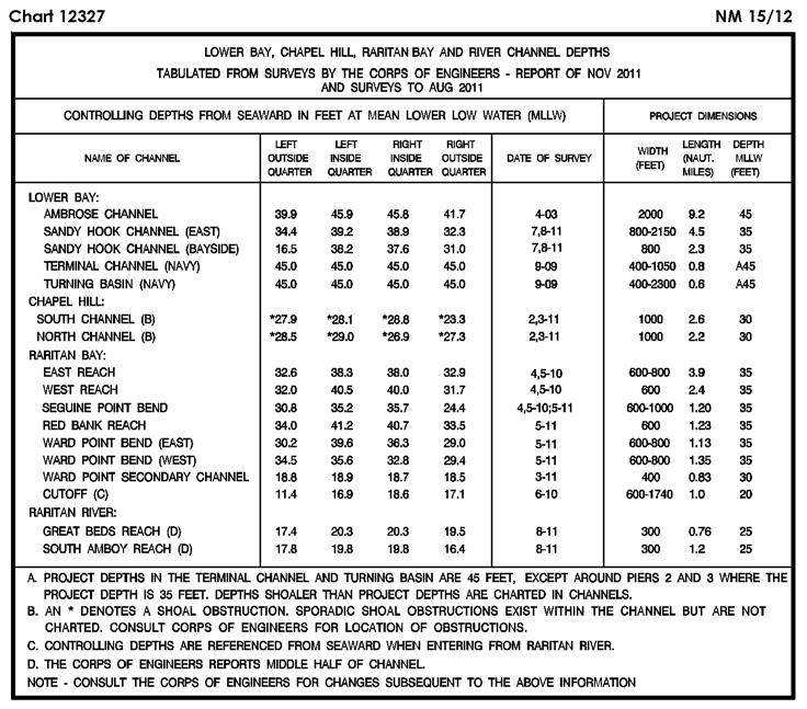
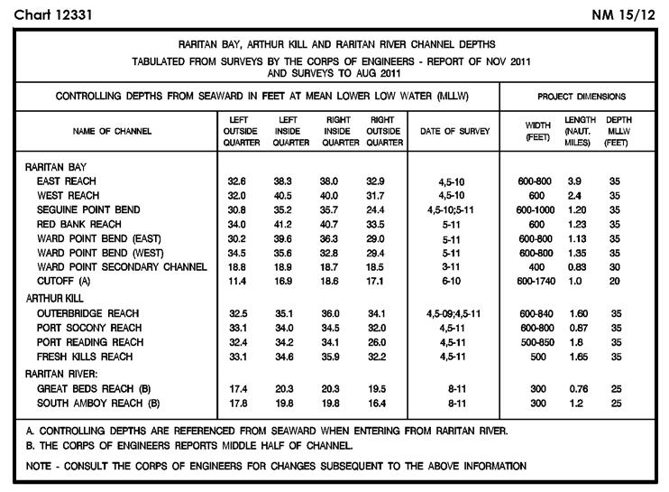
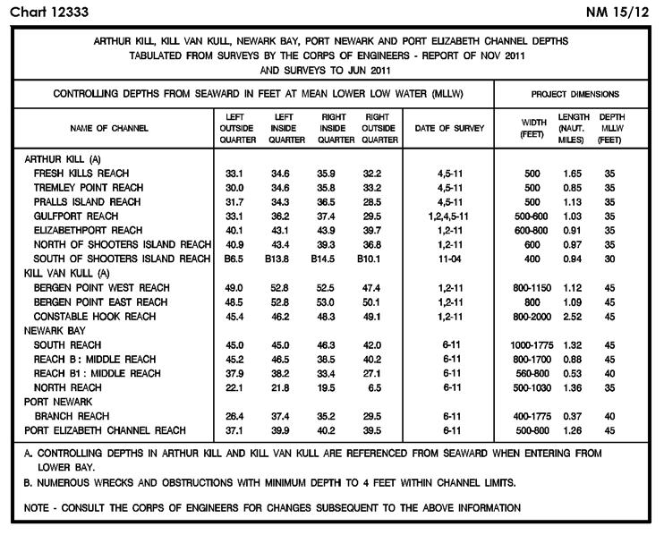
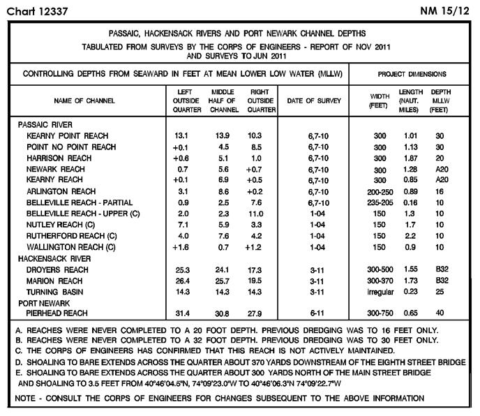
5 SECTION I NM 15/12 CHART CORRECTIONS 1116A Ed. 5/11 LAST NM 13/12 15/12 Add Submerged well (cov 37fms) [L20] marked by buoy Or W, Fl 2.5s (Priv) N W (11/12 CG8) Ed. 10/11 LAST NM 50/11 15/12 Change Legend to 16 FT FOR WIDTH OF 200 FT SEP N W (NOS) Ed. 5/11 LAST NM 13/12 15/12 Add Submerged well (cov 37fms) [L20] marked by buoy Or W, Fl 2.5s (Priv) N W (11/12 CG8) Ed. 8/08 LAST NM 11/12 15/12 Change Light to B Fl Y 2.5s 11ft (Priv) N W (NOS) Ed. 2/12 LAST NM 14/12 15/12 Change Legend to 20 FT APR N W (Inset St Petersburg) Change Legend to 20 FT N W (NOS) Legend to 20 FT APR N W Note to ENTRANCE CHANNEL North quarter Middle half South quarter Apr N W Ed. 1/08 LAST NM 10/12 15/12 Change Light to B Fl Y 2.5s 11ft (Priv) N W (NOS) Ed. 5/11 LAST NM 28/11 15/12 Add Visibility (range) 4M to range light 4, front N W (11/12 CG5) Ed. 12/08 LAST NM 10/12 15/12 Relocate Buoy 1C from N W to N W (11/12 CG5) Ed. 1/10 LAST NM 14/12 15/12 (Side A) Delete Range lights (2), range line and legend SOUTH CHANNEL RANGE between N W N W (13/12 CG7) Ed. 10/10 LAST NM 12/12 15/12 Delete Buoy (YS) AR N W (NOS) Ed. 12/10 LAST NM 12/12 15/12 Delete Range lights (2) and range line between N W N W (13/12 CG7) Ed. 12/11 LAST NM 14/12 15/12 Delete Range lights (2), range line and legend SOUTH CHANNEL RANGE between N W N W (13/12 CG7) Ed. 8/10 LAST NM 10/12 15/12 Delete Buoy (YS) AR N W (NOS) Ed. 6/08 LAST NM 1/12 15/12 (Side B) Add Visibility (range) 4M to range light 4, front N W (11/12 CG5) Ed. 5/04 LAST NM 24/09 15/12 Change Range light, front to 4 QR 16ft 4M N W (11/12 CG5) Ed. 11/10 LAST NM 13/12 15/12 Add Tabulations (3) of controlling depths from Subsection I-2 (See 1, 10/ ) (NOS) Ed. 1/10 LAST NM 10/12 15/12 Add Tabulation of controlling depths from Subsection I-2 (Supersedes 10/ ) (NOS) Ed. 11/10 LAST NM 10/12 15/12 Add Tabulation of controlling depths from Subsection I-2 (Supersedes 10/ ) (NOS) Ed. 7/11 LAST NM 11/12 15/12 Add Buoy P Y, Fl Y 4s (Priv) N W (11/12 CG5) Ed. 3/11/06 LAST NM N11/12 N15/12 Add Buoy P Y, pillar, Fl Y 4s (Priv) N W (11/12 CG5) Ed. 9/07 LAST NM 36/11 15/12 Add Buoy P Y, Fl Y 4s (Priv) N W (11/12 CG5) Ed. 11/10 LAST NM 1/12 15/12 Add Visibility (range) 4M to range light 4, front N W (11/12 CG5) Ed. 11/09 LAST NM 11/12 15/12 Change Legend to 16 FT FOR WIDTH OF 200 FT SEP N W (NOS) Ed. 11/09 LAST NM 10/12 15/12 Change Legend to 21 FEET JUN N W Legend to 24 1 / 2 FEET JUN N W Legend to 19 1 / 2 FT JUN N W Legend to 30 1 / 2 FT JUL 2010-JUN N W Legend to 21 FEET MAR 2008-JUN N W (See 21/ ) Add (NOS) Tabulations (2) of controlling depths from Subsection I-2 (See 1, 10/ ) Ed. 10/05 LAST NM 21/11 15/12 Change Legend to 21 FEET MAR 2008-JUN N W (Supersedes 21/ ) (continued on next page) I-1.1
6 NM 15/12 SECTION I (Continued) Add Tabulations (2) of controlling depths from Subsection I-2 (NOS) Ed. 10/10 LAST NM 11/12 15/12 (Page 13) Delete Light N W Light N W Ed. 5/10 LAST NM 14/12 15/12 Add Buoy P Y, Fl Y 4s (Priv) N W (11/12 CG5) Ed. 9/10 LAST NM 12/12 15/12 (Page D, Inset 3) Delete Light (undesignated) N W Light N W Light N W Add Light 1 FG 14ft (Priv) N W Light 2 FR 14ft (Priv) N W Light 1 FG 14ft (Priv) N W (10/12 CG1) Add Light A QG 19ft (Priv) N W Light B QR 19ft (Priv) N W (Page 29) Delete Light N W Light N W Add Light A QG 19ft (Priv) N W Light B QR 19ft (Priv) N W (Page 30) Change Light 1 to A QG 19ft (Priv) N W and delete legend PA Light 2 to B QR 19ft (Priv) N W (12/12 CG9) Ed. 4/04 LAST NM 48/11 15/12 Delete Light (undesignated) N W Light N W Add Light 1 FG 14ft (Priv) N W Light 2 FR 14ft (Priv) N W Light 1 FG 14ft (Priv) N W (10/12 CG1) Ed. 8/06 LAST NM 37/11 15/12 Delete Light N W Change Light to QG 19ft (Priv) N W and delete legend PA Add Light QR 19ft (Priv) N W (12/12 CG9) Ed. 12/11 LAST NM 6/12 15/12 Delete Light N W (10/12 CG1) Ed. 8/04 LAST NM 51/11 15/12 Delete Fish pen area centered N W Note: Mooring buoy remains (11/12 CG1) Ed. 4/04 LAST NM 28/11 15/12 Delete Fish pen area and buoys (2) in vicinity N W Note: Mooring buoy remains (11/12 CG1) Ed. 7/02 LAST NM 22/10 15/12 Add Buoy NE W Or, Fl 2.5s (Priv) N W Ed. 12/10 LAST NM 53/11 15/12 Change Light 1 to A QG 19ft (Priv) N W Light 2 to B QR 19ft (Priv) N W (12/12 CG9) Ed. 10/4/96 LAST NM N5/01 N15/12 Add Depth 25 meters N W (9(7565)10 Ottawa) Ed. 12/04 LAST NM 34/08 15/12 Change Visibility (range) of light 3 to 5M N W (Inset) Change Visibility (range) of light 3 to 5M N W (12/12 CG17) (11/12 CG1) Buoy NW W Or, Fl 2.5s (Priv) N W Buoy SE W Or, Fl 2.5s (Priv) N W Buoy SW W Or, Fl 2.5s (Priv) N W Ed. 5/10 LAST NM 28/10 15/12 Add Buoy NE W Or, Fl 2.5s (Priv) N W Buoy NW W Or, Fl 2.5s (Priv) N W Buoy SW W Or, Fl 2.5s (Priv) N W (11/12 CG1) Ed. 8/06 LAST NM 14/12 15/12 Change Light to QG N W Light to QR N W (12/12 CG9) Ed. 1/07 LAST NM 44/11 15/12 Delete Light N W Light N W Add Light A QG (Priv) N W Light B QR (Priv) N W (12/12 CG9) Ed. 11/29/02 LAST NM N13/12 N15/12 Delete Legend Breakers Brisants Rep N W Depth 18 meters N W Add Depth 4.9 meters N W Depth 8.8 meters N W Depth 13.4 meters N W Depth 2.7 meters N W Depth 8.2 meters Rk [K14.2] N W Depth 2.3 meters Rk [K14.2] N W (8, 9(3602)10 Ottawa) Ed. 12/08 LAST NM 8/12 15/12 Change Visibility (range) of light to 14M N W (13/12 CG13) Ed. 4/11 LAST NM 6/12 15/12 Delete Position circle TOWER N W Change Position circles (2) and legend MARKERS between N W N W Visibility (range) of light to 14M N W (Inset) Delete Position circle TOWER N W (continued on next page) I-1.2
7 SECTION I NM 15/ (Continued) Position circles (4) MARKERS, dashed lines (3) and legend COURSE...MILE between N W N W (NOS; 13/12 CG13) Ed. 10/11 LAST NM 12/12 15/12 (Page A) Change Visibility (range) of light to 14M N W (Page B, Inset Blaine) Delete Position circle TOWER N W Position circles (4) MARKERS, dashed lines (3) and legend COURSE...MILE b between N W N W (NOS; 13/12 CG13) Ed. 1/07 LAST NM 47/11 15/12 Change Visibility (range) of light to 14M N W (13/12 CG13) Ed. 4/05 LAST NM 6/12 15/12 Add Depth 4 fathoms 2 feet N W (8(3441)10 Ottawa) Ed. 10/10 LAST NM 10/12 15/12 Change Visibility (range) of light to 14M N W Add Submarine pipeline (sewer) [L41.1] between N W N W (NOS; 13/12 CG13) Ed. 6/11 LAST NM 12/12 15/12 Change Visibility (range) of light to 14M N W (13/12 CG13) Ed. 11/09 LAST NM 4/12 15/12 Add Chartlet, depicting changes in hydrography, from Subsection I N W (NOS) Ed. 5/09 LAST NM 11/12 15/12 (Page B, Inset 7) Add Submarine pipeline (sewer) [L41.1] joining N W N W N W Add (NOS) (Page C) Submarine pipeline (sewer) [L41.1] between N W N W Ed. 7/06 LAST NM 10/12 15/12 Add Submarine pipeline (sewer) [L41.1] between N W N W (NOS) Ed. 4/8/06 LAST NM N44/11 N15/12 Add Submarine pipeline (sewer) [L41.1] joining N W N W N W (NOS) Ed. 3/7/98 LAST NM N47/11 N15/12 Change Note 7 of NOTES to 7. Floating security barriers have been installed at various U.S. Naval installations throughout Puget Sound. The barriers are marked by numerous flashing yellow (Fl Y 2s) Navy maintained lighted buoys and approximately mark the Restricted Areas surrounding the facility N W (NOS) Ed. 5/16/98 LAST NM N47/11 N15/12 Change Note to Floating security barriers have been installed at various U.S. Naval installations throughout Puget Sound. The barriers are marked by numerous flashing yellow (Fl Y 2s) Navy maintained lighted buoys and approximately mark the Restricted Areas surrounding the facility N W (NOS) Ed. 7/1/05 LAST NM N9/12 N15/12 Add Depth 8 meters N W Depth 9.5 meters N W (8(3441)10 Ottawa) Ed. 10/11 LAST NM 13/12 15/12 Change Visibility (range) of light to 14M N W (13/12 CG13) Ed. 10/06 LAST NM 13/12 15/12 (Inset) Relocate Buoy 2 from N W to N W (10/12 CG13) Ed. 5/08 LAST NM 38/11 15/12 Delete Dashed line (dump site limit) joining N W N W N W (NOS) Dashed line (dump site limit) and legend DUMP SITE...surveys of 2007 joining N W N W N W N W Dashed-line area, legend (discontinued) and arrow in vicinity N W Dashed line (dump site limit), legend Dump Site...Surveys of 2007 and arrow joining N W N W N W Ed. 9/11 LAST NM 11/12 15/12 Delete Light (Q (Priv)) N W Change Characteristic of light to Fl Y 10s N W Add Light 5 Fl Y 2s (Priv) N W (NOS; 9/12 CG13) Ed. 6/11 LAST NM 9/12 15/12 (Left Panel) Add Light 3 Fl Y 4s (Priv) N W Light 3 Fl Y 4s (Priv) N W Light 3 Fl Y 4s (Priv) N W (9/12 CG13) Ed. 4/09 LAST NM 9/12 15/12 Change Legend to ALTERNATE 17 FT SEP N W (continued on next page) I-1.3
8 NM 15/12 SECTION I (Continued) Legend to 17 FT SEP 2011 (NOS) N W Ed. 6/09 LAST NM 13/12 15/12 Change Legend to ALTERNATE BARGE CHANNEL 17 FT SEP N W Legend to BARGE CHANNEL 17 FT SEP N W (NOS) Ed. 9/05 LAST NM 9/12 15/12 (Upper Panel) Change Legend to 17 FT SEP 2011 ALTERNATE N W Legend to 17 FT SEP N W Visibility (range) of light 50 to 3M N W (NOS; 12/12 CG13) Ed. 10/21/00 LAST NM 40/10 15/12 Delete Depth 26 feet N W Depth contour and blue tint between N W N W (NTM0008/2012) Ed. 5/23/87 LAST NM 14/12 15/12 Change Light to Fl 5s 106m 18M N W Visibility (range) of light to 10M N W (3(206)12 Taunton) Ed. 11/6/93 LAST NM 51/11 15/12 (Panel B) Delete Light N W Change Light to Fl WR 3s 7m 9M N W Add Light Fl 6s 26m 23M N W (3(206)12 Taunton) Ed. 5/06 LAST NM 8/12 15/12 (Upper Panel) Add Buoy G, Fl G 2.5s (Priv) N W (Lower Panel) Add Buoy G, Fl G 2.5s (Priv) N W (12/12 CG13) Ed. 12/19/81 LAST NM 51/11 15/12 Delete Light N W Change Light to Fl 15s 26m 23M N W Add Light Fl 6s 26m 23M N W (3(206)12 Taunton) Ed. 4/06 LAST NM 46/11 15/12 (Inset Redwood Creek) Change Legend to OVHD PWR CABS (3) AUTH CL 155 FT N W (See 33/ ) (NOS) Ed. 8/11 LAST NM 43/11 15/12 Change Legend to 17 FEET SEP N W Legend to 18 FEET MAR-SEP N W Legend to 19 FEET FOR MID-WIDTH OF FEET MAR-SEP N W Add Depth 10 feet N W Depth 11 feet N W Depth 13 feet N W Depth 13 feet N W Depth 16 feet N W Depth 16 feet N W Depth 16 feet N W Depth 16 feet N W Depth 16 feet N W Depth 16 feet N W Depth 16 feet N W Depth 16 feet N W Depth 17 feet N W (NOS) Ed. 7/11 LAST NM 41/11 15/12 (Inset) Change Legend to 17 FEET SEP N W Legend to 18 FEET MAR-SEP N W Legend to 19 FEET FOR MID-WIDTH OF FEET MAR-SEP N W Add Depth 1 fathom 4 feet N W Depth 1 fathom 5 feet N W Depth 2 fathoms 4 feet N W Depth 2 fathoms 4 feet N W Depth 2 fathoms 4 feet N W Depth 2 fathoms 4 feet N W Depth 2 fathoms 4 feet N W Depth 2 fathoms 5 feet N W (NOS) Ed. 12/11 LAST NM 7/12 15/12 Delete Buoy F N W Buoy A N W Buoy G N W Buoy D N W Buoy B N W Buoy E N W Buoy C N W (13/12 CG7) Ed. 7/15/95 LAST NM 5/12 15/12 Add Danger circle Obstn [K40] N W (NTM0002/2012) Ed. 11/26/94 LAST NM 40/10 15/12 Add Danger circle Obstn [K40] N W (NTM0002/2012) Ed. 7/12/08 LAST NM 11/12 15/12 Substitute Depth 40 meters Wk [K26] for wreck N E (31(50)11 Hamburg) Ed. 5/17/08 LAST NM 11/12 15/12 Substitute Depth 40 meters Wk [K26] for wreck N E (31(50)11 Hamburg) Ed. 2/17/05 LAST NM N14/12 N15/12 Substitute Depth 22 meters Obstn [K41] for 25 meters Obstn N E (12(143)12 Den Haag) Ed. 4/9/11 LAST NM N13/12 N15/12 Substitute Depth 22 meters Obstn [K41] for 25 meters Obstn N E (12(143)12 Den Haag) Ed. 2/3/07 LAST NM 13/12 15/12 Add Depth 40 meters Wk [K26] N E Depth 30.2 meters Wk [K26] N E Danger area [K1] Numerous boulders bound by dotted line joining N E N E N E N E (31(50), 32(50)11, 8(49)12 Hamburg) I-1.4
9 SECTION I NM 15/ Ed. 7/19/08 LAST NM 14/12 15/12 Substitute Depth 22 meters Obstns [K41] for 25 meters Obstns N E (12(143)12 Den Haag) Ed. 2/28/09 LAST NM 9/12 15/12 Add Depth 40 meters Wk [K26] N E (31(50)11 Hamburg) Ed. 12/6/08 LAST NM 51/11 15/12 Add Danger area [K1] Numerous boulders bound by chart border and dotted line joining N E N E N E N E N E (32(50)11 Hamburg) Ed. 6/21/08 LAST NM 13/12 15/12 Substitute Depth 30.2 meters Wk [K26] for foul ground symbol N E (8(49)12 Hamburg) Ed. 7/25/98 LAST NM 13/12 15/12 Add Foul ground symbol [K31] N E (32(46)11 Hamburg) Ed. 4/4/09 LAST NM N13/12 N15/12 Substitute Depth 22 meters Obstn [K41] for 25 meters Obstn N E (12(143)12 Den Haag) Ed. 6/25/11 LAST NM N12/12 N15/12 Substitute Depth 22 meters Obstn [K41] for 25 meters Obstn N E (12(143)12 Den Haag) Ed. 3/4/06 LAST NM 6/12 15/12 Delete Depth 6.8 meters N E Depth contour (5-meter) between Substitute Depth 5.3 meters for 6 meters Depth 7.8 meters for 8.5 meters N E N E N E N E Add Depth 4.6 meters N E Depth 4.5 meters N E Ed. 12/18/93 LAST NM 8/12 15/12 Add Submarine cable [L30.1] joining N E N E N E N E N E N E (5(43057)12 Stavanger) Ed. 6/5/93 LAST NM 11/12 15/12 Add Pole [Q90] N E Pole [Q90] N E (5(43197, 43198)12 Stavanger) Ed. 1/8/11 LAST NM 12/12 15/12 Add Position circle Mast (R Lt) N E (340(6991)11 Norrkoping) Ed. 3/17/07 LAST NM N50/11 N15/12 Relocate Buoy from N E to N E Buoy from N E to N E Light from N E to N E (392(7726), 394(7761)12 Norrkoping) Ed. 6/8/96 LAST NM 34/11 15/12 Add Position circle Mast (R Lt) N E (340(6991)11 Norrkoping) Ed. 11/1/08 LAST NM N49/11 N15/12 Relocate Pilot station symbol from N E to N E (392(7738)12 Norrkoping) Ed. 8/4/07 LAST NM N52/11 N15/12 Relocate Pilot station symbol from N E to N E (392(7738)12 Norrkoping) Ed. 4/3/93 LAST NM 12/12 15/12 Relocate Dolphin from N E to N E (Plan) Relocate Dolphin from N E to N E (8(51)12 Hamburg) (12(142)12 Den Haag) Depth contour (5-meter) joining N E N E N E Ed. 11/21/09 LAST NM 12/12 15/12 Relocate Pilot station symbol from N E to N E (392(7738)12 Norrkoping) Ed. 6/15/96 LAST NM 31/11 15/12 Delete Light Aboti N W (See 17/ ) (1(2)12 Reykjavik) Ed. 1/4/97 LAST NM 9/12 15/12 Add Dangerous submerged rock [K13] N E (5(43001)12 Stavanger) Ed. 6/28/97 LAST NM 9/12 15/12 Add Dangerous submerged rock [K13] N E (5(43001)12 Stavanger) Ed. 3/23/96 LAST NM 5/12 15/12 Add Buoy Y, pillar, X topmark, Fl Y 4s [Q130.6] N E Buoy Y, pillar, X topmark, Fl Y 4s [Q130.6] N E Buoy Y, pillar, X topmark, Fl Y 4s [Q130.6] N E Buoy Y, pillar, X topmark, Fl Y 4s [Q130.6] N E Buoy Fairway RW, pillar, ball topmark, L Fl 10s [Q130.5] N E (4, 8/12 Valletta) Ed. 6/18/94 LAST NM 51/04 15/12 Substitute Depth 0 fathom 5 feet Rk [K14.1] for 1 fathom 2 feet N E Depth 0 fathom 4 feet Rk [K14.1] for 1 fathom 3 feet N E Add Depth 4 fathoms 3 feet Rk [K14.2] N E (5(43181)12 Stavanger) Ed. 6/22/96 LAST NM 5/12 15/12 Relocate Buoy from N E to N E (See 19/ ) Add Buoy Y, pillar, X topmark, Fl Y 4s [Q130.6] N E Buoy Y, pillar, X topmark, Fl Y 4s [Q130.6] N E (continued on next page) I-1.5
10 NM 15/12 SECTION I (Continued) Buoy Fairway RW, pillar, ball topmark, L Fl 10s [Q130.5] N E (4, 7, 8/12 Valletta) Ed. 7/21/07 LAST NM N5/12 N15/12 Relocate Buoy from N E to N E (See N19/ ) Add Buoy Fairway RW, pillar, ball topmark, L Fl W 10s [Q130.5] N E (4, 7/12 Valletta) Ed. 3/15/03 LAST NM N14/12 N15/12 Add Wreck [K29] N E (12/06 Tehran) Ed. 1/26/02 LAST NM 11/12 15/12 Add Light Fl(2) 9s to buoy N E (See 31/ ) (10/08 Tehran) Ed. 9/20/08 LAST NM 14/12 15/12 Add Light Fl(2) 9s to buoy N E (10/08 Tehran) Ed. 9/21/96 LAST NM 14/12 15/12 Add Depth 9.7 meters Wk [K26] N E (2(92)12 St. Petersburg) Ed. 9/20/08 LAST NM N14/12 N15/12 Add Light Fl(2) 9s to buoy N E (10/08 Tehran) Ed. 2/8/97 LAST NM 45/11 15/12 Add Depth 9.7 meters Wk [K26] N E (2(92)12 St. Petersburg) Ed. 2/1/03 LAST NM 14/12 15/12 Add Wreck [K29] N E (12/06 Tehran) Ed. 7/15/06 LAST NM 41/06 15/12 Add Stranded wreck [K24] marked by buoy G, pillar, Fl(3) G 7s N E (Plan) Add Stranded wreck [K24] marked by buoy G, pillar, Fl(3) G 7s N E (11/06 Tehran) Ed. 2/1/03 LAST NM N14/12 N15/12 Add Wreck [K29] N E (12/06 Tehran) Ed. 11/26/05 LAST NM 32/10 15/12 Change Buoy No 5 to No 6 YB, pillar, double cone topmark points downward, VQ + L Fl 10s N E Buoy No 6 to No 5 G, pillar, cone topmark, Fl(2) G 6s N E Buoy No 7 to No 8 R, pillar, can topmark, Fl R 6s N E Buoy No 8 to No 7 G, pillar, cone topmark, Fl G 6s N E (Fr CH 7546) Ed. 10/29/05 LAST NM 32/10 15/12 Change Buoy No 5 to No 6 YB, pillar, double cone topmark points downward, VQ + L Fl 10s N E Buoy No 6 to No 5 G, pillar, cone topmark, Fl(2) G 6s N E Buoy No 7 to No 8 R, pillar, can topmark, Fl R 6s N E Buoy No 8 to No 7 G, pillar, cone topmark, Fl G 6s N E (Fr CH 7546) Ed. 8/11/07 LAST NM 11/12 15/12 Add Light Fl(2) 9s to buoy N E (10/08 Tehran) Ed. 3/1/03 LAST NM 14/12 15/12 Add Wreck [K29] N E (12/06 Tehran) Ed. 2/1/03 LAST NM 8/12 15/12 Add Buoy YB, pillar, double cone topmark points downward, Q(6) + L Fl 15s [Q130.3] N E (3/07 Tehran) Ed. 2/1/03 LAST NM N8/12 N15/12 Add Buoy YB, pillar, double cone topmark points downward, Q(6) + L Fl 15s [Q130.3] N E (3/07 Tehran) Ed. 3/15/03 LAST NM 14/12 15/12 Add Wreck [K29] N E (12/06 Tehran) I Ed. 7/15/06 LAST NM 42/06 15/12 Add Stranded wreck [K24] marked by buoy G, pillar, Fl(3) G 7s N E (11/06 Tehran) Ed. 9/1/90 LAST NM 53/11 15/12 (Plan) Delete Position circles TOWER (R Lt) (2), range line and legend between N E N E Stranded wreck Stranded wreck Foul area in vicinity (See 22/ ) (6(84)12 Dehra Dun) N E N E N E Ed. 10/10/87 LAST NM 20/11 15/12 Delete Superbuoy Dagon N E (6(86)12 Dehra Dun) Ed. 4/7/07 LAST NM N20/11 N15/12 Delete Superbuoy Dagon N E (6(86)12 Dehra Dun) Ed. 10/10/87 LAST NM 45/10 15/12 Delete Superbuoy Dagon N E (6(86)12 Dehra Dun) Ed. 8/24/85 LAST NM 18/02 15/12 Add Pilot station symbol [T1.1] N E (NTM0010/2012) Ed. 6/20/98 LAST NM 40/98 15/12 Delete Buoy N E Add Pilot station symbol [T1.1] N E Buoy 0 RW, pillar, ball topmark, Mo(A) [Q130.5] N E Buoy 1 G, pillar, cone topmark, Fl G 4s N E Buoy 2 R, pillar, can topmark, Fl R 4s N E Buoy 3 G, pillar, cone topmark, Fl G 4s N E Buoy 4 R, pillar, can topmark, Fl R 4s N E Buoy 5 G, pillar, cone topmark, Fl G 4s N E (continued on next page)
11 SECTION I NM 15/ (Continued) Buoy 6 R, pillar, can topmark, Fl R 4s N E Buoy 7 G, pillar, cone topmark, Fl G 4s N E Buoy 8 R, pillar, can topmark, Fl R 4s N E Buoy 9 G, pillar, cone topmark, Fl G 4s N E Buoy 10 R, pillar, can topmark, Fl R 4s N E Buoy 11 G, pillar, cone topmark, Fl G 4s N E Buoy 12 R, pillar, can topmark, Fl R 4s N E Buoy B1 G, pillar, cone topmark, Fl G 4s N E Buoy B2 R, pillar, can topmark, Fl R 4s N E Buoy B3 G, pillar, cone topmark, Fl G 4s N E Buoy B4 R, pillar, can topmark, Fl R 4s N E Buoy B5 G, pillar, cone topmark, Fl G 4s N E Buoy B6 R, pillar, can topmark, Fl R 4s N E Buoy X1 Y, pillar, X topmark, Fl Y 4s [Q130.6] N E Buoy X2 Y, pillar, X topmark, Fl Y 4s [Q130.6] N E Buoy 12A R, pillar, X topmark, Fl Y 4s N E Buoy 12B R, pillar, X topmark, Fl Y 4s N E Land tint to area bound by shore and solid line [F13] joining N E N E N E N E Double solid line with land tint (pier) [F14] between N E N E Buoy Y, pillar, X topmark, Fl Y 4s [Q130.6] N E Buoy G, pillar, cone topmark, Fl G 4s N E Buoy G, pillar, cone topmark, Fl G 4s N E Buoy G, pillar, cone topmark, Fl G 4s N E Buoy R, pillar, can topmark, Fl R 4s N E (NTM0010/2012) Ed. 4/24/93 LAST NM 26/04 15/12 Add Stranded wreck [K24] N E (NTM0010/2012) Ed. 6/15/96 LAST NM 26/04 15/12 Add Stranded wreck [K24] marked close NE by buoy BRB, pillar, double ball topmark, Fl(2) N E (NTM0010/2012) I-1.7

12 SECTION I NM 15/12 I-2.1

13 SECTION I NM 15/12 I-2.2

14 SECTION I NM 15/12 I-2.3

15 SECTION I NM 15/12 I-2.4

16 SECTION I NM 15/12 I-2.5
17 SECTION I NM 15/12 CHARTS AFFECTED BY NOTICE TO MARINERS NM 52/11 THROUGH NM 15/12 Note: N indicates Not For Sale; P indicates Preliminary; T indicates Temporary; * indicates New Edition/New Chart; ** indicates Chart Canceled Chart Ed. Notice to Mariners / / / / / / / / / ,8,13/ / / / ,10,14/ /11;3,7,10/ / ,14/ / / / / / ,12/ ,14/ ,12/ / ,13/ / / / / / / / A 6/ A 8,9,11,13/ A 52,53/11;2,6,7,8,9,11,12, 13,15/ A 52,53/11;8,9,12/ /11;7,8,9,11/ / / /12* ,53/11;8,9,12/ / N3/ / / / N3/ / / /11;13,14/ ,9,13/ ,9,13/ *,11/ ,11,13/ ,9,11,13/ ,9,13/ ,53/11;6,9,11/ /12* ,9,11,14/ ,53/11;2,6,7,8,9,11,12, 13,15/ ,12,13,14/ ,12,13/ /12* / ,13,14/ ,9,11,14/ / ,11/ ,11/ ,14/ /11;11,14/ ,53/11;2,7,11/ ,53/11;1,7,9,11,13, 14/ ,2,3,8,9,11/ ,9,11,13/ ,53/11;1,11,13,14/ N8,N9,N11,N13/ /11;11,14/ *,14/ ,8,9,11,13,14/ / /12* Chart Ed. Notice to Mariners *,12/ ,3,6,8,9,11/ /12* /12* /11;1,13/ /11;1,13/ ,3,12,13/ /11;13/ / ,12/ ,12/ / / / ,13,14/ ,13,14/ *,15/ / N6/ ,5,11/ ,6/ N5,N6/ ,6/ / / / / / / ,9/ / / / / /11*;9/ / / *,11/ / / N10/ / N10/ ,10,11,13/ N10/ ,9/ /11;9,12/ / N52/ N3,N6,N10,N11,N12, N13/ ,12,13/ /11;4,13/ / ,10/ ,14/ /11;3,9/ /12* /11;13/ ,4,9,10,13,14/ /11;3,6,12/ ,10,13,14/ /11;6,9,14/ ,9,12/ /11;5,9,12,14,15/ ,5,10,12,15/ ,12,15/ / / *,12,14,15/ N5,N10/ /12* /11;9,10,12/ ,10,11/ /12* ,10,15/ ,11/ /12* / / /12* ,5,10,11,15/ N1,N5,N10,N11,N15/ / ,10/ / /12 Chart I-3.1 Ed. Notice to Mariners *,11/ / / ,15/ ,8,10,11/ ,11/ ,8,11/ /12* / ,7,11/ / / / ,8/ ,15/ / ,15/ ,10,15/ / / / ,7,11/ ,7/ /11*;11/ / ,10,11/ / / /12* / / *,11/ / / / / / N14/ / ,10,15/ ,10,14/ /12* / ,15/ / / / /11;1,9,10,13,15/ ,10,15/ ,10,15/ /11;1,9,10,15/ ,9/ / / / / /12* ,10,11/ ,11/ / ,9/ / / ,3,7,10/ /12* / / N1,N12/ ,5,7,11,12,14,15/ ,7,12,14/ ,7,12/ / N12/ / ,9,10/ / / ,7,10/ / ,9/ ,8,9/ *,9/ /11;2,7,8,13/ /12* ,15/ / ,12/12 Chart Ed. Notice to Mariners / *,15/ *,12/ / ,7,12/ N1,N7,N12/ / / / / / / /12* *,13/ ,13/ / *,13/ / / / / / / ,12/ ,7/ / / / / / / / / / ,2/ / / / / /11;2/ ,15/ / / / / / / /11;11,15/ / / /11;15/ N9/ N9/ N13/ N14/ N15/ N12/ N7/ N7/ N11/ N11/ N13/ N9,N13/ N12/ N12/ N12/ N12/ N7/ / / / ,4/ /12* / ,4/ / / / /12* /12* /12* /12* / N11/ /12* /12* /12*
18 NM 15/12 SECTION I CHARTS AFFECTED BY NOTICE TO MARINERS NM 52/11 THROUGH NM 15/12 Note: N indicates Not For Sale; P indicates Preliminary; T indicates Temporary; * indicates New Edition/New Chart; ** indicates Chart Canceled Chart Ed. Notice to Mariners Chart Ed. Notice to Mariners Chart Ed. Notice to Mariners Chart Ed. Notice to Mariners / /12* /12* /12* /11;8,9/ /11;8,9/ N11/ N11/ / N11/ N11/ N11,N13/ ,8/ N8/ N11/ N7,N11/ N8,N11/ N9/ N9/ N9/ N11,N13/ N13/ N3,N13,N15/ N13/ /11;10,11/ N52/11;N10/ ,5,7,13/ N2,N10/ N7/ ,7,13/ N3,N7/ N2,N10/ ,10/ /12* /11;2,10,11/ ,5,7,8,15/ N13/ / ,6,15/ /11*;4,5,6,8,10,12, 15/ / / / ,15/ / N9,N11/ N9/ N9/ ,4,8,10,15/ ,8,9,10,12,15/ ,10/ ,15/ ,4,8,10,11,15/ / ,10,15/ ,4,8,10/ ,4,8/ N13/ / / N15/ N15/ / N15/ ,5/ N9,N15/ N10/ / ,8,13,15/ N10,N11,N14/ N13/ ,12/ ,8,9,11/ ,4,8,10,11/ ,11/ / ,3,5,13,15/ / ,11,15/ ,9,10/ / ,15/ ,15/ ,10,13,15/ / ,15/ ,15/ /12* / / / / / / / / / /12* /12* ,9/ ,9/ ,4,5,8,9,14/ ,5,8,14/ / /11;1,4,6,8,14/ ,5/ ,11/ / / / / ,2,9,10/ ,11/ / /11;7,11/ / /11;2,11/ N52/ / / / N52/11;N7,N11/ ,6/ / N8/ / / / / / / N5,N8,N11/ ,8,11/ / / ,11/ / N1/ / / / / N8/ / / N8/ ,14/ / / / / / ,4,5,8,10,11/ ,4,5,8,10,11/ / / N2/ ,10/ N9/ / ,9/ / / / / / / ,5,8,10/ / /11;5/ /11;5/ / /12 I / / / ,8/ / / ,8/ ,8/ ,8/ / / / / / / / / /11;5,9/ /11;5,9/ /11;9/ /11;5,9/ / / / N3/ / / ,8/ / / ,7,8/ / / /11;4/ / /11;3,13/ / N53/ N53/11* N10/12* / N53/11* / N53/ N3/ / ,7/ ,7/ / / N6/ / / N3/12* N53/ ,6,10/ / / / N8,N10/ / N8/ N6/ N6/ / / / ,10/ / N5/ N5/ / / ,13/ N1/ / / / / / ,8/ / / N14/ /11;14/ / / / ,15/ / / /11;14/ / / ,12/ ,12/ / ,6,7,9,13/ ,7,9,10,13/ / / ,14/ ,14/ / / / ,13/ / / /11;5,8,13/ / / / / / /11;1/ / /12* / *,15/ /12* / / ,12/ / *,8/ /12* / / / / / / N3/ / / / / / / / ,10,14/ / ,15/ ,13/ / / / N3/12* / / / ,10/ / /11;14/ / /11;9,14/ / / / / ,14/ / ,10/ / / / /12* / / N1/12* N1/12* ,14/ N52/11
19 SECTION I NM 15/12 CHARTS AFFECTED BY NOTICE TO MARINERS NM 52/11 THROUGH NM 15/12 Note: N indicates Not For Sale; P indicates Preliminary; T indicates Temporary; * indicates New Edition/New Chart; ** indicates Chart Canceled Chart Ed. Notice to Mariners N8/ N2/12* N3/12* N5*,N14/ N52/ N14/ N10,N13/ N8/ N12/ /12* N53/11;N10,N13/ N53/11;N13/ N13/ N13/12* N2/12* N13/12* N8/ N8/ /11;1,9,10,11,15/ N5/12* ,9,10,11,15/ N1*,N8/ / N3/12* / / N5/12* N14,N15/ N10/ / / / N6,N8/ N1,N2,N8,N13,N15/ N10/ N5,N8/ ,9,11,12,13,15/ ,11,12,13,14,15/ /11;9,15/ N52/ / ,12,13,15/ N8,N12/ ,11,13/ /11;8,12/ N4,N12,N13/ ,13,15/ ,13/ N4*,N13/ N13/ N2,N4/ / ,13/ N2,N13/ N2,N8,N12,N13,N15/ N53/11*;N2,N13/ N2,N8,N12,N15/ ,53/11;5/ ,6,15/ / / / ,8/ / / / N52/ / / / N4/ N4/ / / ,15/ ,15/ / ,13/ / N10,N12,N13/ ,53/11;4,8,12/ / / / / / /12 Chart Ed. Notice to Mariners ,8,9/ / ,9/ / / / / / / / / / / / / / / ,8,15/ ,8/ ,9/ ,13/ ,7,9/ / / N4*,N6,N7,N13/ N7/ /11;2,7/ / ,11/ ,13/ / ,15/ N11/ / ,13/ / / ,6/ / /11;12,14/ ,11,12/ N11/ ,5,11,12,15/ N15/ / / N11/ /12** N15/ N52/11;N15/ N52/ N8/12* N12/ ,12/ / ,15/ / / / / / / ,12,15/ ,12/ /11;12,14/ / ,13/ ,9,14/ ,13,14/ N13,N14/ N6,N13/ ,12/ N6,N9/ N14/ / / /11;6,9,14/ N5*,N6,N13/ / / /11;5,14/ N6/ N14/ N5/ /11;1,12,14/ N4,N14/ N2,N4,N5,N12,N14/12 Chart I-3.3 Ed. Notice to Mariners N53/11;N2,N4,N5,N12, N14/ ,14/ / / / / / N8/ N8/ / / / N8,N12/ N8/ / / / N11/ N6/12* ,13/ / / / ,11/ ,11/ ,11,13/ ,13/ / / ,8/ ,11/ / ,4,7,8,13/ / ,4/ ,8/ / / ,13/ / N53/11* / N13/ N13/ / ,9/ / / / / / / / / ,9,13/ / ,15/ ,15/ N5,N15/ ,9/ / /11;7/ / /11;7/ /11;7/ / / / / /11;12/ ,13/ ,6/ N53/ / /11;11/ / / ,4,6,12/ / / / / / / / /12 Chart Ed. Notice to Mariners / / / / ,6/ ,7/ / / ,8/ ,8,9/ ,9/ / / / /11;9/ / ,11/ / / / ,12/ ,9/ ,13/ / ,9,12,13/ ,11,13/ ,13/ ,7/ ,7/ / / / /11;4,5,7,9,12/ /11;8/ / ,9/ / / ,14,15/ ,12,14/ ,14/ ,14/ N13/ / / ,6,7,12,14/ N10,N12/ / / / ,10/ / / N9/ ,13/ ,13/ ,12,13/ / ,11/ / ,12/ ,12/ / /11;8,12/ / / / / / / / / / / N1/12* / ,9,11/ ,11,12,14,15/ N8,N11,N12,N14, N15/ / / / / / / /12
20 NM 15/12 SECTION I CHARTS AFFECTED BY NOTICE TO MARINERS NM 52/11 THROUGH NM 15/12 Note: N indicates Not For Sale; P indicates Preliminary; T indicates Temporary; * indicates New Edition/New Chart; ** indicates Chart Canceled Chart Ed. Notice to Mariners ,11/ / / / / / / / / ,15/ ,10,14/ / N8/ ,10,14/ /12* ,10,11,14,15/ ,12,14/ ,15/ N8,N15/ ,10,14,15/ N5,N10,N14,N15/ ,14/ N11,N14/ ,11,12/ N3,N11,N12/ / ,11,15/ ,14,15/ N11,N14,N15/ / / / / / / / ,14/ / / / / /11;14/ / N14/ N53/ N53/ N53/ / /11;15/ ,7/ / / / / / / / / / N15/ / /11;9/ ,6/ / / /11;9/ /11;9/ / / / N7/ / /11;4,5,7,8/ N52/11;N5,N7/ N52/11;N5,N7/ N52/11*;N4,N5,N7/ /11;4,5,7/ N52/11;N7,N8/ N4,N7/ N52/11;N5/ / /11;5,7,9/ N6/12* N4/12* / / /12 Chart Ed. Notice to Mariners / / / / / / / / / / / / / / / /11;4/ / / /11;6/ / / / / / / / / / / N10/ N10/ N10/ N10/ / N10/ / / / / / / / / / N12/ N12/ / / /11;5,10,11,13/ ,5,9,11/ ,5,9,11/ ,8,10,11/ ,11,13/ ,13/ ,11/ / / / / *,9,10/ / / / ,13/ / ,4,8/ N2,N4,N8/ ,8/ / ,10/ ,10/ / / / /11;10,11,12/ /11;3,5,10,11,12/ / / / / / / / / / / /12 Chart I-3.4 Ed. Notice to Mariners /11;5,7/ / /11;7,10/ N8/12* /11;7/ / / ,11/ ,11/ ,11/ / / / ,13/ / / N5/ /12* /12* / / / *,8/ / / / / / / / N53/11;N10,N12/ / / / N12/ N12/ / /11*;5,9/ ,14/ / / / / / / / N9/ N6/12* N53/11* / / / ,8/ / ,8/ N8/12* / N13/12* / N6/12* / / N1/12* / / /11;1/ N13/ N1/12* / N2/ N1/ /12** N9/12* N5/12** N5/12* /12** N5/12* N53/ / / / / / / N5/12* N12/12* N9/12** Chart Ed. Notice to Mariners N9/12** N9/12* N9/12* / /11** / N52/11* N3/12* /12** /12** / N6/12* N53/ /12** N14/12* N13/12* N6/12* N3/12* N6/12* N6/ N13/12* /11;6/ /12** N6/ / /11;6/ / /12** / /11;6/ N53/ / N13/12** / /11* / /12** N4/12* N53/ N53/11;N11/ N6/ N10/ N5/12* N13/ N5/12* N3/12* N5*,N13/ N8/ N2/ N53/ N1,N2/ N8/12
21 SECTION II NM 15/12 NAVIGATION PUBLICATIONS COAST PILOT CORRECTIONS COAST PILOT 5 39 Ed 2011 Change 10 LAST NM 12/12 Page 208 Paragraph 3924; insert after: (2)(i) For the marine waters of the State of California, the following vessels are completely prohibited from discharging any sewage (whether treated or not): (A) A large passenger vessel; (B) A large oceangoing vessel equipped with a holding tank which has not fully used the holding tank s capacity, or which contains more than de minimis amounts of sewage generated while the vessel was outside of the marine waters of the State of California. (ii) For purposes for paragraph (b)(2) of this section: (A) Marine waters of the State of California means the territorial sea measured from the baseline as determines in accordance with the Convention on the Territorial Sea and the Contiguous Zone and extending seaward a distance of three miles, and all enclosed bays and estuaries subject to tidal influences from the Oregon border ( North Latitude, West Longitude, decimal degrees, NAD 1983) to the Mexican border ( North Latitude, West Longitude, decimal degrees, NAD 1983). A map illustration these waters can be obtained from EPA or viewed at charge/over view.html. (B) A large passenger vessel means a passenger vessel, as defined in section 2101(22) of title 46, United States code, of 300 gross tons or more, as measured under the Internation Convention on Tonnage Measurement system in 46 U.S.C , or the regulatory measurement system of 46 U.S.C for vessels not measured under 46 U.S.C , that has berths or overnight accommodations for passengers. (C) A large oceanogoing vessel means a private, commercial, government, or military vessel of 300 gross tons or more, as measured under the Internation Convention on Tonnage Measurement of Ships, 1969, measurement system in 46 U.S.C , or the regulatory measurement system of 46 U.S.C for vessels not measured under 46 U.S.C , that is not a large passenger vessel. (D) A holding tank means a tank specifically designed, constructed, and fitted for the retention of treated or untreated sewage, that has been designated and approved by the ship s flag Administration on the ship s stability plan; a designated ballast tank is not a holding tank for this purpose. (FR 02/27/12) 15/12 Page 293 Paragraph 34, lines 4 to 5; read: Panacea. In 2011, the midchannel controlling depth was 5 feet to the public wharf. The channel (L ) 15/12 Page 319 Paragraph 57, lines 13 to 14; read: 2011, the midchannel controlling depth in the channel was 6 feet with 4.5 to 6 feet in the turning basin. An overhead power cable, NE (L ) 15/12 Page 332 Paragraph 221, lines 7 to 10; read: 3.5 miles above the State Route 613 bridge. In 2011, the controlling depth was 7.5 feet to the State Route 613 bridge, thence 5.5 feet to the (L ; L ) 15/12 Page 333 Paragraph 237, lines 13 to 14; read: 8 feet to Light 18, thence 6.5 feet at midchannel to the (L ; L ) 15/12 Page 335 Paragraph 258, lines 4 to 8; read: the entrance to Industrial Seaway. In 2011, the midchannel controlling depth was 10 feet from State Route 90 highway bridge to Popps Ferry Road highway bridge, thence 10 feet at michannel to the seaway. The channel (L ; L ) 15/12 Page 336 Paragraph 268, lines 7 to 8; read: In 2011, the controlling depth was 6.5 feet to the highway bridge. The highway (L ) 15/12 Page 336 Paragraph 270, lines 10 to 12; read: vicinity of Three Rivers Road. In 2011, the midchannel controlling depth was 9 feet to the turning basin, thence 4.5 to 10.5 feet in the basin. The channel is marked by lights. Plans provide (L ) 15/12 Page 340 Paragraph 322, lines 6 to 7; read: moles. In 2011, the controlling depth was 7 feet in the entrance channel; thence in 2009, 5.4 to 6.2 feet in the anchorage (L ) 15/12 COAST PILOT 5 39 Ed 2011 Change 11 Page 311 Paragraph 287, lines 2 to 3; read: N arm of East Bay. In 2011, the controlling depth was 6 feet to Light 30, thence 8 feet to the town. (L ) 15/12 II-1.1
22 SECTION II NM 15/12 COAST PILOT 5 (Continued) Page 318 Paragraph 45, lines 6 to 9; read: at miles 1.6 and 2.5 respectively. In 2011, the controlling depth was 6.5 feet to Daybeacon 30, thence 4.5 feet to the head of the project, thence a depth of 6 feet was available in both (L ) 15/12 Page 321 Paragraph 68, lines 3 to 6; read: McDuffie Island and the mainland. (See Notice to Mariners and latest edition of charts for controlling depths.) (10/12 CG8; L ) 15/12 Page 341 Paragraph 329, line 5; read: controlling depth was 5.5 feet. The (L ) 15/12 Page 341 Paragraph 333, lines 3 to 4; read: miles above the mouth of the river. In 2011, the controlling depth was 6 feet. The channel is marked by a (L ) 15/12 Page 361 Paragraph 102, lines 2 to 4; read: river via the Jump with the Gulf. In 2012, the midchannel controlling depth was 5 feet in the entrance channel to the entrance, thence 2 feet at michannel to the junction with the (DD 21479; DD 21480; DD 21321) 15/12 Page 409 Paragraph 293, lines 13 to 15; read: in operation continuously. In 2012, the controlling depth was 6 feet in the entrance channel to the lock; thence in 2011, 5 feet through the canal to Light 20, thence 10 (DD 21483; DD 20946; DD 20947) 15/12 Page 495 Paragraph 110, lines 2 to 5; read: 682/Structure C) bridge of the Pinellas Bayway was under construction in 2012; upon completion, it will be replaced with a high-level fixed bridge. (02/12 CG7; L ) 15/12 Page 501 Paragraph 207, lines 3 to 4; read: diesel fuel, pump-out, berths, dry and wet storage, lifts to 99 tons, and marine supplies are available. In 2011, 10 feet (DB small) 15/12 Page 513 Paragraph 377, lines 8 to 15; read: 13 feet. Caution: The open bascule span overhangs the channel above a vertical clearance of 75 feet. The bridgetender monitors VHF-FM channel 16 and works and channel 13; call sign KYH-532. (See through and 11766, chapter 2, for drawbridge regulations.) The bridgetender monitors VHF-FM channel 13. An (L ; FR 6/2/11) 15/12 COAST PILOT 5 39 Ed 2011 Change 12 Page 310 Paragraph 278, lines 8 to 15; read: sand, and trailers on barges. An overhead power cable crosses the bayou 0.25 mile above the mouth with a clearance of 88 feet. The Barrancas Avenue highway bridge, 0.5 mile above the mouth, has a fixed span with a clearance of 65 feet. A fixed bridge with a clearance of 14 feet crosses the bayou about 1.6 miles above the mouth. Pensacola Yacht Club and basin (NOS 11383; L ; L ) 15/12 Page 436 Paragraph 160, lines 4 to 6; read: Orangefield. In 2011, the controlling depth in the channel was 7 feet, thence 5.5 to 8.5 feet in the basin. In 1996, a draft of 4.5 (L ) 15/12 Page 436 Paragraph 161, lines 3 to 5; read: Sabine River to the first fixed highway bridge. In 2011, the controlling depth was 3 feet. The highway bridge has a fixed span with (L ) 15/12 Page 443 Paragraph 251, lines 4 to 6; read: basin. In 2011, the controlling depth was 37.5 feet in the channel and 40.5 feet in the basin. The channel is marked by a private. (L ) 15/12 Page 457 Paragraph 457, lines 6 to 7; read: Waterway. In 2011, the controlling depth was 12 feet to the Monsanto basin. It was (L ) 15/12 Page 465 Paragraph 59, lines 8 to 10; read: Intracoastal Waterway. In , the midchannel controlling depth was 3 feet to about 25.2 miles above the mouth; thence in 1994, the (L ) 15/12 Page 469 Paragraph 115, lines 8 to 10; read: , the midchannel controlling depth was 10 feet to the turning basin, thence 11 feet was available in the basin. A 330- (L ) 15/12 II-1.2
23 COAST PILOT 5 (Continued) Page 514 Paragraph 403, lines 3 to 4; read: River. In 2011, the midchannel controlling depth was 6.5 feet. (L ) 15/12 Page 514 Paragraph 406, lines 4 to 7; read: Matagorda Bay and Matagorda Bay. In 2011, the midchannel controlling depth was 5 feet to the Intracoastal Waterway. The Gulf entrance (L ) 15/12 Page 515 Paragraph 407, lines 3 to 4; read: of Bay City Barge Terminal. In 2011, the controlling depth was 3.5 feet (5 feet at midchannel) with 6.5 to 9 feet (L ) 15/12 SECTION II NM 15/12 II-1.3
24 SECTION II CORRECTIONS TO C. G. LIGHT LIST, VOLUME I ATLANTIC COAST, 2011 (1) (2) Name and Location (3) Position (4) Characteristic (5) Height (6) Range (7) Structure (8) Remarks 430 Boston Approach Lighted Buoy BF NOAA Remove from list. 937 KENDALL HEAD AQUACULTURE LIGHTS (4) 1011 GROVE POINT AQUACULTURE LIGHTS (8) Note: Asterisks (*) indicate that column(s) in which a correction has been made or new information added. Denotes a new entry when preceding the station number. II-2.1 Remove from list. Remove from list. *Delete Heading: Cross Island AQUACULTURE LIGHT NW Remove from list AQUACULTURE LIGHT NE Remove from list AQUACULTURE LIGHT W Remove from list AQUACULTURE LIGHT E Remove from list AQUACULTURE LIGHT SW Remove from list AQUACULTURE LIGHT SE Remove from list Cross Island Aquaculture Lighted Buoy CI-A Cross Island Aquaculture Lighted Buoy CI-B Cross Island Aquaculture Lighted Buoy CI-C Cross Island Aquaculture Lighted Buoy CI-D *Add Heading: Starboard Island Aquaculture Lighted Buoy SI-SW Aquaculture Lighted Buoy SI Aquaculture Lighted Buoy SI-NW Aquaculture Lighted Buoy SI-NE Aquaculture Lighted Buoy SI-SE N W Fl Y 2.5s Yellow. Private aid. * N W Fl Y 2.5s Yellow. Private aid. * N W Fl Y 2.5s Yellow. Private aid. * N W Fl Y 2.5s Yellow. Private aid. * N W Fl Y 2.5s Yellow. Private aid. * N W Remove from list. Fl Y 2.5s Yellow. Private aid. * N W Fl Y 2.5s Yellow. Private aid N W Fl Y 2.5s Yellow. Private aid. *
25 SECTION II CORRECTIONS TO C. G. LIGHT LIST, VOLUME I ATLANTIC COAST, 2011 (1) (2) Name and Location (3) Position (4) Characteristic (5) Height (6) Range (7) Structure (8) Remarks Aquaculture Lighted Buoy SI6 Remove from list Aquaculture Lights (8) Remove from list FLINT ISLAND AQUACULTURE LIGHTS (4) 2031 Marsh Creek Aquaculture Buoy SW 2034 Marsh Creek Aquaculture Buoy NE Scrag Island Aquaculture Lighted Buoy SI-A Scrag Island Aquaculture Lighted Buoy SI-B Scrag Island Aquaculture Lighted Buoy SI-C Scrag Island Aquaculture Lighted Buoy SI-D Scrag Island Aquaculture Lighted Buoy SI-E Scrag Island Aquaculture Lighted Buoy SI-E N W Remove from list. Remove from list. Remove from list. Fl Y 2.5s Yellow. Private aid N W Fl Y 2.5s Yellow. Private aid N W Fl Y 2.5s Yellow. Private aid N W Fl Y 2.5s Yellow. Private aid N W Fl Y 2.5s Yellow. Private aid N W Fl Y 2.5s Yellow. Private aid The Cuckolds Light N W Channel Buoy N W Channel Buoy N W Channel Buoy N W LIGHT N W Fl (2) W 6s 1s fl 1s ec. 1s fl 3s ec White octagonal tower on dwelling. Red nun. Green can. Red nun. Fl R 6s 24 5 TR on skeleton tower. Emergency light of reduced intensity when main light is extinguished. HORN: 1 blast ev 15s (2s bl). Activated for 45 minutes during periods of reduced visibility by keying the microphone 5 times on VHF channel 83A. Maintained from Apr. 1 to Dec. 1. Maintained from Apr. 1 to Dec. 1. Maintained from Apr. 1 to Dec. 1. Note: Asterisks (*) indicate that column(s) in which a correction has been made or new information added. Denotes a new entry when preceding the station number. II-2.2
26 SECTION II CORRECTIONS TO C. G. LIGHT LIST, VOLUME I ATLANTIC COAST, 2011 (1) (2) Name and Location (3) Position (4) Characteristic (5) Height (6) Range (7) Structure (8) Remarks NANTUCKET FERRY SLIP 1 FOG LIGHT NANTUCKET FERRY SLIP 1 LIGHT NANTUCKET FERRY SLIP 2 LIGHT NANTUCKET FERRY SLIP 2 FOG LIGHT OAK BLUFFS FERRY SLIP FOG LIGHT OAK BLUFFS FERRY SLIP LIGHT OAK BLUFFS FERRY SLIP LIGHT OAK BLUFFS FERRY SLIP LIGHT N W STROBE 14 White. Shown only when authority vessels approach dock in fog. Private aid. * * * * * N W F G 14 Private aid N W F R 14 Private aid. * N W STROBE 25 Shown only when authority vessels approach dock in fog. Private aid. * N W STROBE 25 Wharf end dolphin. Shown only when authority vessels are approaching dock in fog. Maintained from June 15 to Sept. 10. Private aid. SIREN: 1 blast ev 15s (3s bl). Remove from list N W F R 14 Private aid N W F G 14 Private aid. * FERRY SLIP FOG LIGHT N W FERRY SLIP 2 LIGHT N W STROBE 22 On Roof. Shown only when authority vessels approach dock in fog. Private aid. F R 14 Private aid. * FERRY SLIP LIGHT 4 Remove from list FERRY SLIP 1 LIGHT N W F G 14 Private aid. * * FERRY SLIP 1 LIGHT N W *19741 Garden State Offshore Energy Temporary Research Lighted Buoy NJORD N W LIGHT N W BREAKWATER LIGHT 2A N W F R 14 Private aid. Fl Y 2s Yellow. Private aid. 15/12 15/12 Fl R 4s 27 4 TR on skeleton tower. Fl R 4s 27 5 TR on skeleton tower. Note: Asterisks (*) indicate that column(s) in which a correction has been made or new information added. Denotes a new entry when preceding the station number. II-2.3
27 SECTION II CORRECTIONS TO C. G. LIGHT LIST, VOLUME I ATLANTIC COAST, 2011 (1) (2) Name and Location (3) Position (4) Characteristic (5) Height (6) Range (7) Structure (8) Remarks ENTRANCE LIGHT 2A N W CHANNEL LIGHT N W LIGHT N W FITCH POINT LIGHT N W *26007 Bronxonia Yacht Club Lighted No Wake Buoy N W Fl R 4s 27 4 TR on skeleton tower. Fl G 4s 22 4 SG on skeleton tower. Q R 26 4 TR on pipe tower on concrete base. Fl G 2.5s 29 4 SG on skeleton tower. Fl W 2.5s White with orange bands. Private aid. 15/12 CORRECTIONS TO C. G. LIGHT LIST, VOLUME II ATLANTIC COAST, 2011 (1) (2) Name and Location (3) Position (4) Characteristic (5) Height (6) Range (7) Structure (8) Remarks Buoy N W Green can. * Channel Buoy N W CHANNEL LIGHT N W CHANNEL LIGHT N W CHANNEL LIGHT N W CHANNEL LIGHT N W LIGHT N W Green can. Fl G 2.5s 15 3 SG on pile. 15/12 Fl G 2.5s 15 3 SG on pile. Light equipment removed from Dec. 1 to Mar. 15. Fl G 6s 18 4 SG on pile. Light equipment removed from Dec. 1 to Mar. 15. Fl R 4s 18 3 TR on pile. Light equipment removed from Dec. 1 to Mar. 15. Fl G 4s 15 4 SG on pile. Light equipment removed from Nov. 25 to Apr Buoy N W Green can Buoy N W Green can Buoy N W Green can. Note: Asterisks (*) indicate that column(s) in which a correction has been made or new information added. Denotes a new entry when preceding the station number. II-2.4
28 SECTION II CORRECTIONS TO C. G. LIGHT LIST, VOLUME III ATLANTIC AND GULF COAST, 2012 (1) (2) Name and Location (3) Position (4) Characteristic (5) Height (6) Range (7) Structure (8) Remarks 2115 RABBIT ISLAND CHANNEL RANGE FRONT LIGHT N W Q R 25 KRW-I on tower on pile. Visible 1.5 each side of range line. - RANGE FRONT LIGHT Remove from list. - RANGE REAR LIGHT 627 yards, 269 from front light Barnwell Island Flats Lighted Buoy N W LIGHT N W Vieques Island East Warning Buoy A Vieques Island East Warning Buoy B Vieques Island East Warning Buoy C Vieques Island East Warning Buoy D Vieques Island East Warning Buoy E Vieques Island East Warning Buoy F Vieques Island East Warning Buoy G SOUTH CHANNEL RANGE FRONT LIGHT - SOUTH CHANNEL RANGE REAR LIGHT 627 yards, 269 from front light. * LIGHT 21A N W LIGHT N W RANGE A REAR LIGHT 320 yards, from front light. Fl R 4s 5 Red. Q R 12 4 TR on dolphin. Fl G 4s 12 5 SG-SY on pile. Q R 10 4 TR-TY on dolphin. Remove from list. Remove from list. Remove from list. Remove from list. Remove from list. Remove from list. Remove from list. Remove from list. Remove from list. Remove from list. * * * Remove from list. 15/12 Note: Asterisks (*) indicate that column(s) in which a correction has been made or new information added. Denotes a new entry when preceding the station number. II-2.5
29 SECTION II CORRECTIONS TO C. G. LIGHT LIST, VOLUME III ATLANTIC AND GULF COAST, 2012 (1) (2) Name and Location (3) Position (4) Characteristic (5) Height (6) Range (7) Structure (8) Remarks LIGHT 21A Remove from list RANGE B REAR LIGHT 210 yards, 059 from front light RANGE D REAR LIGHT 240 yards, from front light. * LIGHT N W LIGHT N W LIGHT N W Remove from list. Remove from list. Q R 16 4 TR-TY on pile. 15/12 Fl G 4s 16 5 SG-SY on pile. Fl R 4s 12 5 TR-TY on pile. CORRECTIONS TO C. G. LIGHT LIST, VOLUME IV GULF OF MEXICO, 2011 (1) (2) Name and Location (3) Position (4) Characteristic (5) Height (6) Range (7) Structure (8) Remarks *957 Nippon Lighted Buoy N W TROPICAL BEND UPPER LIGHT 31 RDB mile N W A RANGE FRONT LIGHT N W Q R Red. Marks subsea installation. SIGN: NIPPON-WC-534-A. Private aid. 15/12 Iso G 6s 7 SG on skeleton tower on piles. Iso W 2s (Night) Fl W 2.5s (Day) On pile with platform. Visible all around; higher intensity 1.5 each side of rangeline. CORRECTIONS TO C. G. LIGHT LIST, VOLUME VI PACIFIC COAST AND PACIFIC ISLANDS, 2012 (1) (2) Name and Location (3) Position (4) Characteristic (5) Height (6) Range (7) Structure (8) Remarks ENTRANCE RANGE REAR LIGHT 386 yards, 061 from front light N W Iso R 6s 50 KRB on skeleton tower on multi-pile structure. Visible 1.5 each side of rangeline. * * Smith Island Light N W Fl W 10s Skeleton tower. 50 * * CORRECTIONS TO C. G. LIGHT LIST, VOLUME VII GREAT LAKES AND THE ST. LAWRENCE RIVER ABOVE THE ST. REGIS RIVER, 2012 (1) (2) Name and Location (3) Position (4) Characteristic (5) Height (6) Range (7) Structure (8) Remarks Lighted Buoy N W Fl G 4s 4 Green. Note: Asterisks (*) indicate that column(s) in which a correction has been made or new information added. Denotes a new entry when preceding the station number. II-2.6
30 SECTION II CORRECTIONS TO C. G. LIGHT LIST, VOLUME VII GREAT LAKES AND THE ST. LAWRENCE RIVER ABOVE THE ST. REGIS RIVER, 2012 (1) (2) Name and Location (3) Position (4) Characteristic (5) Height (6) Range (7) Structure (8) Remarks Lighted Buoy N W Lighted Buoy N W Lighted Buoy N W Lighted Buoy N W Lighted Buoy N W Lighted Buoy N W 9745 Russell Island Shoal Lighted Buoy RI 9775 Roberts Landing Lighted Buoy N W N W Shoal Lighted Buoy N W 9825 Fawn Island Upper End Lighted Buoy N W *Add Heading: Bay Port Harbor * Buoy N W * Buoy N W * Buoy N W * Buoy N W * Buoy N W * Buoy N W Fl R 4s 4 Red. Fl R 2.5s 4 Red. Fl R 4s 4 Red. Maintained from Mar. 28 to Dec. 21. Fl G 2.5s 4 Green. Replaced by can from Dec. 21 to Mar. 28. Fl R 2.5s 4 Red. Maintained from Apr. 7 to Dec. 14. Fl G 4s 4 Green. Maintained from Apr. 7 to Dec. 14. Fl (2+1) G 6s 4 Green and red bands. Replaced by can from Dec. 21 to Apr. 1. Fl G 4s 4 Green. Maintained from Apr. 1 to Dec. 21. Fl R 4s 4 Red. Replaced by nun from Dec. 21 to Apr. 1. Q R 4 Red. Replaced by nun from Dec. 21 to Apr. 1. Green can. Red nun. Green can. Red nun. Green can. Red nun. Maintained from Apr. 21 to Nov /12 Maintained from Apr. 21 to Nov /12 Maintained from Apr. 21 to Nov /12 Maintained from Apr. 21 to Nov /12 Maintained from Apr. 21 to Nov /12 Maintained from Apr. 21 to Nov /12 Note: Asterisks (*) indicate that column(s) in which a correction has been made or new information added. Denotes a new entry when preceding the station number. II-2.7
31 SECTION II CORRECTIONS TO PUB 110, LIST OF LIGHTS, 2011 EDITION (1) (2) Name and Location (3) Position (4) Characteristic (5) Height (6) Range (7) Structure (8) Remarks Breakwater, west. Remove from list. J Punta Perret. J N W Fl.W. period 15s fl. 1s, ec. 14s White framework tower, red bands; 79. * * Cabo San Roman. J N W Fl.W. period 6s fl. 1s, ec. 5s White octagonal framework tower, orange band; 82. * * * Punta Aguide. J N W Fl.W.R. period 3s fl. 1s, ec. 2s White metal framework tower, orange bands; 39. * * Morro Choroni. J N W Fl.W. period 5s fl. 0.9s, ec. 4.1s White metal structure; 20. * * La Orchila, jetty. J N W Fl.W. period 4s fl. 0.3s, ec. 3.7s White metal tower, orange band; 7. * * * * R6. J N W Iso.G. period 8s 15/ Punta Atalaya. G S W Fl.W. period 6s fl. 0.5s, ec. 5.5s Coast Guard radio mast. * * La Plata breakwater, E. beacon., G 0872 Km. 7, S W Q.(6)+L.Fl.G. period 10s PORT (B) G, tower, topmark. Radar reflector. * Breakwater, west beacon, Km G , S W Q.(6)+L.Fl.R. period 10s STARBOARD (B) R, tower, topmark. Radar reflector. * Beacon, Km. 6, S G W Fl.(4)R. period 16s fl. 0.5s, ec. 1.5s fl. 0.5s, ec. 1.5s fl. 0.5s, ec. 1.5s fl. 0.5s, ec. 9.5s STARBOARD (B) R, tower, topmark. Radar reflector. * * * Note: Asterisks (*) indicate that column(s) in which a correction has been made or new information added. Denotes a new entry when preceding the station number. II-3.1
32 SECTION II CORRECTIONS TO PUB 110, LIST OF LIGHTS, 2011 EDITION (1) (2) Name and Location (3) Position (4) Characteristic (5) Height (6) Range (7) Structure (8) Remarks Km. 6, S G W Fl.(4)G. period 16s fl. 0.5s, ec. 1.5s fl. 0.5s, ec. 1.5s fl. 0.5s, ec. 1.5s fl. 0.5s, ec. 9.5s PORT (B) G, tower, topmark. Radar reflector. * * * Km. 5, S G W Fl.(4)G. period 16s fl. 0.5s, ec. 1.5s fl. 0.5s, ec. 1.5s fl. 0.5s, ec. 1.5s fl. 0.5s, ec. 9.5s PORT (B) G, tower, topmark. Radar reflector. * * * Km. 5, S G W Fl.(4)R. period 16s fl. 0.5s, ec. 1.5s fl. 0.5s, ec. 1.5s fl. 0.5s, ec. 1.5s fl. 0.5s, ec. 9.5s STARBOARD (B) R, tower, topmark. Radar reflector. * * * Km. 4, S G W Fl.(4)G. period 16s fl. 0.5s, ec. 1.5s fl. 0.5s, ec. 1.5s fl. 0.5s, ec. 1.5s fl. 0.5s, ec. 9.5s PORT (B) G, tower, topmark. Radar reflector. * * * Km. 4, S G W Fl.(4)R. period 16s fl. 0.5s, ec. 1.5s fl. 0.5s, ec. 1.5s fl. 0.5s, ec. 1.5s fl. 0.5s, ec. 9.5s STARBOARD (B) R, tower, topmark. Radar reflector. * * * Km. 2,505, W. side of channel S G W Fl.(3)R. period 9s fl. 0.8s, ec. 1.2s fl. 0.8s, ec. 1.2s fl. 0.8s, ec. 4.2s STARBOARD (B) R, tower, topmark. * CORRECTIONS TO PUB 115, LIST OF LIGHTS, 2011 EDITION (1) (2) Name and Location (3) Position (4) Characteristic (5) Height (6) Range (7) Structure (8) Remarks Korngarour. Remove from list. Note: Asterisks (*) indicate that column(s) in which a correction has been made or new information added. Denotes a new entry when preceding the station number. II-3.2
33 SECTION II NM 15/12 PUBLICATIONS AFFECTED BY NOTICE TO MARINERS THROUGH NM 15/12 Note: * indicates New Edition/New Publication; ** indicates Publication Canceled; N indicates Not For Sale Publication Ed. Notice to Mariners Publication Ed. Notice to Mariners Publication Ed. Notice to Mariners NGA/DLIS CATALOGS CATCDLIMDIS Region *,12,13,14,15,16, 18,21,22,23,24,25, 26,27,28,29,31,32, 33,34,35,36,38,39, 40,41,42,43,45,46, 47,48,49,50,51, 53/05;2,3,4,5,6,8,9, 10,11,12,14,15,16, 17,19,20,21,25,26, 27,28,29,30,31,32, 33,34,35,36,37,38, 39,40,41,42,45,46, 48,49,50,51,52/06;1, 3,4,6,7,8,10,11,12, 13,14,17,19,20,22, 23,24,25,26,30,31, 32,33,34,36,37,38, 40,41,43,44,45,46, 47,49,50,51,52/07;1, 5,6,7,8,11,12,13,15, 16,17,18,19,20,21, 22,23,24,25,27,28, 30,31,32,33,34,36, 38,39,40,41,42,43, 44,46,47,48,50, 51/08;1,3,6,7,8,9,10, 11,13,14,15,17,19, 22,23,24,25,26,27, 28,29,30,31,32,34, 35,37,39,40,41,42, 44,46,47,48,52/09;1, 3,4,5,9,10,11,12,15, 17,18,19,23,24,26, 27,28,31,32,34,35, 37,38,40,41,43,44, 46,48,51,52/10;2,3, 4,8,10,11,13,14,15, 16,17,18,19,20,21, 22,23,27,28,31,32, 33,34,35,36,40,41, 43,44,45,47,48,49, 50,51,52,53/11;2,3, 4,6,7,8,10,11,14/12 Region *,25,41/05;8,12, 13,14,20,23,25,26, 27,29,31,37,39, 42/06;3,10,12,13,21, 24,32,34,51/07;21, 31,34,45,48,49/08;1, 3,7,23,25,30,31,39, 41,48,50/09;6,8,10, 11,16,17,19,24,26, 27,28,30,32,35,37, 38,40,43,46,47, 49/10;7,8,9,10,14, 15,18,19,21,23,26, 27,29,34,35,41,45, 49,51,53/11;3,4,6,7, 8,10/12 Region *,12,13,14,16,17, 19,23,24,25,27,31, 32,34,35,37,40,45, 46,47,51/05;4,5,8, 12,15,17,18,20,21, 22,23,25,26,27,29, 30,32,40,42,43,47, 52/06;2,3,4,5,6,7,9, 11,12,13,14,20,21, 24,27,28,29,30,37, 38,42,44/07;6,7,8, 10,16,21,25,26,27, 31,32,33,36,37,38, 46,49,52/08;4,5,16, 20,22,25,33,34,39, 40,41,42,43/09;6,7, 12,13,18,22,26,31, 37,39,46/10;14,18, 21,26,29,32,34,37, 38,40,43,44,53/11;1, 2,3,4,5,6,13/12 Region /05*;20,43/07;17, 20,25,43,45/08;5,26, 29,35,39,42,43,44, 45,49/09;5,11,12,18, 19,27,30,32,44, 49/10;7,8,9,11,15, 16,17,18,21,23,27, 34,42,44,45,48/11;4, 5,8/12 Region *,14,18,20,22,23, 28,36,41,43,45, 49/05;4,5,7,9,10,12, 14,27,32,45/06;3,20, 23,25,28,30,31, 41/07;8,13,17,20,22, 25,29,31,33,36,38, 40,51/08;1,5,6,7,8,9, 10,11,12,16,18,19, 24,25,30,31,38,39, 41,44,48,50/09;5,10, 11,16,17,18,22,26, 27,28,32,37,38,39, 46/10;9,10,14,15,17, 20,21,22,28,34,42, 43,44,53/11;6/12 Region *,18,23,28,43,46, 52/05;5,7,10,12,14, 16,25,30,35,36,40, 41,42,43,45,50/06;3, 6,7,10,12,20,28,30, 35,39,41,42,50/07;3, 7,8,11,13,15,20,22, 32,34,37,43,45, 46/08;7,8,14,16,18, 23,38,41,48/09;10, 19,28,32,46/10;9,10, 11,37/11;1,11/12 Region *,14,43,47,52/05; 12,14,15,17,18,19, 20,21,25,27,35,42, 45,46,47,48,49, 52/06;3,4,8,9,10,11, 12,13,14,15,16,17, 18,19,20,23,30,34, 35,36,39,42,50/07;1, 7,10,16,17,20,22,25, 26,37,42,43,48/08;1, 8,10,11,12,13,14,20, 22,41,43/09;17,22, 36,39,41,42,44,45, 46,47,49/10;9,17,34, 35,52/11;4,6/12 Region *,23,53/05;15,16, 25,32,35,39,52/06; 10,20,23,39,40, 41/07;8,21,36,39,49, 51/08;5,7,14/09;19, 22,24,32,37,42, 49/10;27/11 Region *,43,47,52/05;2,4, 5,8,21,22,25,27,29, 32,39,40,42,45/06;3, 4,7,10,13,21,22,28, 29,34,38,40,41, 50/07;3,7,8,10,17, 19,20,24,25,32,33, 34,36,38,43,45,48, 49/08;1,5,8,9,10,13, 14,18,24,25,30,33, 34,35,39,43,44,48, 50/09;5,10,12,19,32, 38,44,46/10;9,10,11, 12,18,21,22,33,34, 44,45,46,48,49,50, 51,52,53/11;1,3,4,5, 6,8,9,10,12,13,14/12 Miscellaneous Charts and Publications *,12,13,14,15,16, 18,19,20,21,22,24, 25,27,28,29,31,32, 33,35,36,37,38,39, 41,42,43,44,46,47, 48,50,52,53/05;1,3, 4,5,6,7,9,10,11,13, 14,15,16,17,18,19, 20,22,23,24,25,26, 27,28,29,30,31,32, 35,36,39,40,41,42, 44,45,46,49,50,51, 52/06;1,3,4,6,7,10, 13,17,18,19,21,22, 24,26,27,29,30,31, 32,33,34,35,36,37, 38,39,40,43,44,45, 46,47,48,49,50,51, 52/07;1,2,3,4,6,7,8, 9,10,11,12,13,14,16, 17,18,19,21,22,23, 24,25,26,27,28,29, 30,31,32,33,34,35, 36,37,38,39,40,41, 44,45,46,47,48, 52/08;1,2,3,4,6,7,8, 9,10,11,12,13,17,18, 19,20,22,24,25,26, 27,28,29,30,31,32, 34,35,36,37,38,39, 40,41,42,43,45,46, 47,48,49,50,51, 52/09;2,3,4,5,6,7,8, 9,10,11,12,13,14,15, 17,18,19,20,21,22, 23,24,25,26,27,28, 29,30,31,32,33,35, 36,37,38,39,40,41, 42,43,44,45,46,47, 48,50/10;3,4,5,6,7,8, 9,10,11,12,13,14,15, 16,17,18,19,20,21, 22,23,24,25,26,27, 29,30,31,32,33,34, 35,36,38,39,40,41, 42,43,44,45,46,47, 48,50,51,52,53/11;2, 3,4,5,6,7,10,12,13, 14/12 NGA LIST OF LIGHTS PUB *,23,24,25,26,27, 28,30,31,33,35,36, 37,38,39,41,42,43, 44,45,46,47,48,51, 53/11;1,3,4,5,6,7,8, 9,10,12,13,14,15/12 PUB *,37,38,39,40,41, 42,44,45,48,49,51, 52,53/11;2,3,4,7,8,9, 10,11,13,14/12 PUB *,50,51,52,53/11; 1,2,3,4,5,6,7,8,9,10, 11,12,13,14/12 PUB *,46,47,48,49,50, 51,52,53/11;2,3,4,6, 7,8,9,11,12,13,14/12 PUB *,28,29,30,36,37, 40,43,45,47,48,49, 50,51,52,53/11;2,4, 5,6,8,9,10,11,13, 14/12 PUB *,45,47,48,50,51, 52,53/11;2,3,6,7,8,9, 11,12,13,14,15/12 PUB *,31,33,34,36,39, 40,42,44,47,53/11;5, 6,7,12,13,14/12 SAILING DIRECTIONS PUB /11* PUB /11* PUB /10* PUB /11* PUB /10* PUB /10* PUB /11* PUB /11* II-4.1
34 NM 15/12 SECTION II PUBLICATIONS AFFECTED BY NOTICE TO MARINERS THROUGH NM 15/12 Note: * indicates New Edition/New Publication; ** indicates Publication Canceled; N indicates Not For Sale Publication Ed. Notice to Mariners Publication Ed. Notice to Mariners PUB /12* PUB /10* PUB /11* PUB /11* PUB /11* PUB /11* PUB /11* PUB /11* PUB /11* PUB /11* PUB /11* PUB /12* PUB /11* PUB /11* PUB /11* PUB /11* PUB /11* PUB /11* PUB /11* PUB /10* PUB /11* PUB /11* PUB /10* PUB /10* PUB /11* PUB /10* PUB /11* PUB /11* PUB /10* PUB /10* PUB /10* PUB /10* PUB /11* PUB /11* USCG LIGHT LIST VOLUMES I - VII VOLUME I *,13,14,15,16,17, 18,19,20,21,22,23, 24,25,26,27,28,29, 30,31,32,33,34,35, 36,37,38,39,40,41, 42,43,44,45,46,47, 48,49,50,51,52, 53/11;1,2,3,4,5,6,7, 8,9,10,11,12,13,14, 15/12 VOLUME II *,13,14,15,16,17, 18,19,20,21,22,23, 24,25,26,27,28,29, 30,31,32,33,34,35, 36,37,38,39,40,41, 42,43,44,45,46,47, 48,49,50,51,52, 53/11;1,2,3,4,5,6,7, 8,9,10,11,12,13,14, 15/12 VOLUME III *,15/12 VOLUME IV *,17,18,19,20,23, 24,25,27,28,29,30, 31,33,35,36,37,38, 39,40,42,43,44,45, 46,47,48,49,51,52, 53/11;1,2,5,6,7,8,9, 10,11,12,13,14, 15/12 VOLUME V /12* VOLUME VI *,15/12 VOLUME VII *,15/12 DIGITAL PUBS - QUARTERLY DIGITAL PUBS - QUARTERLY 2011 N7/12* FLEET GUIDES PUB N51/11* PUB N51/11* NOS MISCELLANEOUS PUBLICATIONS CATALOG A /09* CATALOG G /09* CATALOG K /09* CATALOG L /09* CATALOG P /09* ALMANACS AIR ALMANAC /11* NAUTICAL ALMANAC /11* COAST PILOT COAST PILOT *,27,30,35,36, 47/11;5,11/12 COAST PILOT /11*;5,11/12 COAST PILOT *,7,12/12 COAST PILOT *,47/11;1,5,11/12 COAST PILOT *,27,32,40,50/11; 7,11,12,15/12 COAST PILOT /12* COAST PILOT /11*;1,7,8,11, 13/12 COAST PILOT *,32,42,50/11; 5/12 COAST PILOT *,42/11;7/12 RADIO NAVIGATIONAL AIDS PUB /05*;9/12 AMERICAN PRACTICAL NAVIGATOR PUB /02*;14,38/03; 40/05 INTERNATIONAL CODE OF SIGNALS PUB /03* WORLD PORT INDEX PUB /11* DISTANCES BETWEEN PORTS PUB /02* RADAR NAVIGATION AND MANEUVERING BOARD MANUAL PUB /01* SIGHT REDUCTION TABLES (MARINE) PUB 229 VOL /71* PUB 229 VOL /71* PUB 229 VOL /71* PUB 229 VOL /71* PUB 229 VOL /71* PUB 229 VOL /70* SIGHT REDUCTION TABLES (AIR) PUB 249 VOL /07* PUB 249 VOL /52* PUB 249 VOL /52* CHART NO. 1 CHART NO N51/11* CHART NO. 4 CHART NO N23/91* ATLAS OF PILOT CHARTS PUB /03* PUB /99* PUB /02* USCG NAVIGATION RULES COMDTINSTM D /99*;52/00;16/04 NOS TIDE TABLES W PACIFIC/INDIAN 2012 N47/11*;N4/12 OCEAN WEST ATLANTIC 2012 N47/11* EUROPE/WEST 2012 N47/11* AFRICA EAST PACIFIC 2012 N47/11* TIDAL CURRENT TABLES ATLANTIC 2012 N47/11* PACIFIC 2012 N47/11* II-4.2
35 SECTION III NM 15/12 BROADCAST WARNINGS Details concerning the particulars of the broadcasting of radio navigational warnings may be found in Radio Navigational Aids, Pub NAVAREA IV The summary of all NAVAREA IV messages in force as of 22 December 2011 is given in Section III of NM 53/11. Warnings issued during the subsequent quarter are issued in NM 13/ /12. CANCELED. Messages in force Z April 2012: 2011 series 385(28) 2012 series 97(11) 143(14) 154(GEN) 174(15,38) 404(GEN) 40(28) 110(GEN) 146(GEN) NAVAREA IV WARNINGS issued from Z March to Z April /12(14). WESTERN NORTH ATLANTIC. 1. CABLE OPERATIONS IN PROGRESS UNTIL Z APR BY CABLESHIP RENE DESCARTES ALONG TRACKLINE JOINING 43-03N W, 43-03N W, 43-09N W, 43-09N W, 43-02N W. WIDE BERTH REQUESTED. 2. CANCEL THIS MSG Z APR. (302053Z MAR 2012) 144/12 and 145/12. CANCELED. 146/12(GEN). 1. NAVAREA IV WARNINGS IN FORCE Z MAR 12. ONLY THOSE WARNINGS ISSUED DURING THE LAST SIX WEEKS ARE LISTED HEREIN SERIES: 97(11), 110(GEN), 143(14), 145(GEN). 2. THE SUMMARY OF ALL NAVAREA IV WARNINGS IN FORCE AS OF 22 DEC 2011 IS GIVEN IN SEC III OF NM 53/11. WARNINGS ISSUED DURING THE SUBSEQUENT QUARTERS ARE SUMMARIZED IN NM 13/ CANCEL NAVAREA IV 130/12. (310936Z MAR 2012) 147/12 thru 153/12. CANCELED. 154/12(GEN). NORTH AMERICAN ICE SERVICE (NAIS) ICEBERG BULLETIN Z APR ICEBERG LIMIT 47-20N W, 45-30N W, 45-45N W, 47-00N W, 59-00N W. 2. WESTERN ICEBERG LIMIT 50-41N W AND 49-46N W. 3. SEA ICE LIMIT: A N W, 47-00N W, 47-50N W, 50-00N W, 51-00N W, 55-00N W, 56-00N W, 58-00N W, 59-00N W, 62-00N W. B N W, 47-10N W, 47-40N W, 47-20N W, 46-30N W, 46-40N W, 48-45N W. C N W, 49-00N W, 49-50N W, 49-45N W. D N W, 50-00N W, 50-30N W, 49-50N W, 48-30N W, 48-15N W. E N W, 59-00N W, 62-00N W, 67-00N W, 62-30N W, 60-00N W. 4. REPORT POSITION AND TIME OF ANY ICEBERGS OR STATIONARY RADAR TARGETS THAT MAY LIKELY BE ICEBERGS TO THE NEAREST CANADIAN COAST GUARD MARINE COMMUNICATIONS AND TRAFFIC SERVICE STATION OR USING INMARSAT CODE CANCEL THIS MSG Z APR. (042203Z APR 2012) III-1.1
36 SECTION III NM 15/12 HYDROLANTS The summary of all HYDROLANTS in force as of 22 December 2011 is given in Section III of NM 53/11. Warnings issued during the subsequent quarter are issued in NM 13/ /12. CANCELED. Messages in force Z April 2012: 2008 series 1879(24) 208(24) 511(24) 668(35,37,43) 733(24) 1354(24) 1880(GEN) 212(57) 536(51) 670(24) 734(54) 1463(24) 1923(37) 231(56) 537(35) 676(55) 735(51) 1852(37) 1966(37) 255(37) 539(35) 680(56) 737(24) 2010 series 2053(37) 277(24) 541(24) 683(37,43) 738(25) 845(24) 2220(43) 326(36) 556(24) 686(35,43) 742(54,56) 996(24) 2296(54) 336(24) 567(37) 703(51) 743(55) 2011 series 2297(54) 344(35) 572(37) 706(44) 744(55) 483(24) 2298(54) 356(37) 577(37,43) 707(24) 745(55) 881(56) 2299(54) 394(57) 580(51) 708(51) 746(37) 1291(37) 2300(54) 399(36) 593(24) 709(55) 747(GEN) 1314(52) 2012 series 404(35) 603(55) 711(GEN) 748(36,37) 1318(35) 89(57) 436(56) 608(52,53,56) 715(24) 749(36) 1331(37,43) 101(24) 441(24) 635(11) 716(24) 750(24) 1401(24) 117(53) 452(52) 638(57) 718(24) 751(37) 1536(56) 137(57) 458(57) 641(35,43) 719(GEN) 1617(43) 147(37) 479(37) 645(52) 721(24) 1652(35) 160(38) 481(51) 649(11,28) 723(24) 1681(24) 168(51) 484(37) 652(GEN) 724(24) 1753(37) 192(52) 492(GEN) 663(24) 729(57) 1806(35) 194(24) 507(52) 666(37) 732(51) HYDROLANT WARNINGS issued from Z March to Z April /12(51). EASTERN NORTH ATLANTIC. BAY OF CADIZ. UNDERWATER OPERATIONS Z MAR UNTIL FURTHER NOTICE BY CABLESHIP WAVE SENTINEL IN N W. WIDE BERTH REQUESTED. (291717Z MAR 2012) 704/12 and 705/12. CANCELED. 706/12(44). EASTERN BALTIC SEA. LITHUANIA. HAZARDOUS OPERATIONS. 1. HAZARDOUS OPERATIONS 0900Z TO 1900Z DAILY 03 THRU 06, 11 AND 13 APR IN AREA BOUND BY N E, N E, N E, N E, N E, N E, N E. 2. CANCEL THIS MSG Z APR. 707/12(24). BRAZIL-EAST COAST. 1. MAN OVERBOARD IN S W AT Z MAR. VESSELS IN VICINITY REQUESTED TO KEEP A SHARP LOOKOUT, ASSIST IF POSSIBLE. REPORTS TO ANY COASTAL RADIO STATION. 2. CANCEL HYDROLANT 637/12(57), OPERATIONS COMPLETED. 708/12(51). WESTERN NORTH ATLANTIC. DISTRESS SIGNAL RECEIVED ON 406 MHZ IN N W AT Z MAR. VESSELS IN VICINITY REQUESTED TO KEEP A SHARP LOOKOUT, ASSIST IF POSSIBLE. REPORTS TO RCC NORFOLK, INMARSAT-C: , PHONE: , FAX: , D05-SMB-D5CG@USCG.MIL. (300947Z MAR 2012) (301207Z MAR 2012) (301301Z MAR 2012) III-1.3
37 NM 15/12 SECTION III 709/12(55). BLACK SEA. HAZARDOUS OPERATIONS. 1. HAZARDOUS OPERATIONS Z TO Z AND Z TO Z APR IN AREA BOUND BY N E, N E, N E, N E, N E, N E. 2. CANCEL THIS MSG Z APR. (301313Z MAR 2012) 710/12. CANCELED. 711/12(GEN). EASTERN MEDITERRANEAN SEA. LIBYA TO ITALY. M/V, 55 PERSONS ON BOARD, UNREPORTED TRIPOLI (32-54N E) TO ITALY. VESSELS IN VICINITY REQUESTED TO KEEP A SHARP LOOKOUT, ASSIST IF POSSIBLE. REPORTS TO MRCC ROME, INMARSAT-C: , PHONE: , FAX: , ITMRCC@MIT.GOV.IT. (301353Z MAR 2012) 712/12 thru 714/12. CANCELED. 715/12(24). BRAZIL-SOUTH COAST. CHART LAJE MARAMBAIA LIGHT S W UNLIT. 716/12(24). BRAZIL-SOUTH COAST. CHART PONTA DE GUARATIBA S W UNLIT. (310132Z MAR 2012) (310144Z MAR 2012) 717/12. CANCELED. 718/12(24). BRAZIL-SOUTHEAST COAST. 1. SEISMIC SURVEY IN PROGRESS UNTIL Z APR BY M/V OCEAN EUROPE TOWING 300 METER LONG CABLES IN AREA BOUND BY S W, S W, S W, S W, S W, S W, S W, S W. SIX MILE BERTH REQUESTED. 2. CANCEL THIS MSG Z APR. 719/12(GEN). 1. HYDROLANT WARNINGS IN FORCE Z MAR 12. ONLY THOSE WARNINGS ISSUED DURING THE LAST SIX WEEKS ARE LISTED HEREIN SERIES: 394(57), 399(36), 404(35), 410(37), 436(56), 441(24), 452(52), 458(57), 466(54), 479(37), 481(51), 484(37), 492(GEN), 507(52), 511(24), 516(35), 536(51), 537(35), 539(35), 541(24), 556(24), 567(37), 572(37), 577(37,43), 580(51), 593(24), 603(55), 608(52,53,56), 635(11), 638(57), 641(35,43), 645(52), 646(55), 647(55), 649(11,28), 652(GEN), 653(57), 666(37), 668(35,37,43), 670(24), 676(55), 680(56), 683(37,43), 686(35,43), 689(24), 690(24), 692(52), 693(53), 695(37), 696(24), 697(24), 698(24), 699(24), 703(51), 706(44), 707(24), 708(51), 709(55), 710(54), 711(GEN), 713(24), 715(24), 716(24), 717(24), 718(24). 2. THE SUMMARY OF ALL HYDROLANT WARNINGS IN FORCE AS OF 22 DEC 2011 IS GIVEN IN SEC III OF NM 53/11. WARNINGS ISSUED DURING THE SUBSEQUENT QUARTERS ARE SUMMARIZED IN NM 13/ CANCEL HYDROLANT 438/12, 601/12, 644/12, 654/12. (310210Z MAR 2012) (310939Z MAR 2012) 720/12. CANCELED. III-1.4
38 SECTION III NM 15/12 721/12(24). BRAZIL-SOUTHEAST COAST. 1. SEISMIC SURVEY IN PROGRESS UNTIL Z APR BY M/V NPS WG COOK TOWING 12 FIVE MILE LONG CABLES IN AREA BOUND BY S W, S W, S W, S W. SIX MILE BERTH REQUESTED. 2. CANCEL THIS MSG Z APR. (010052Z APR 2012) 722/12. CANCELED. 723/12(24). BRAZIL-SOUTH COAST. 1. SEISMIC SURVEY IN PROGRESS UNTIL Z APR BY M/V NPS RAMFORM SOVEREING TOWING METER LONG CABLES IN AREA BOUND BY S W, S W, S W, S W. EIGHT MILE BERTH REQUESTED. 2. CANCEL THIS MSG Z APR. 724/12(24). BRAZIL-SOUTHEAST COAST. 1. SEISMIC SURVEY IN PROGRESS UNTIL Z APR BY M/V NPS OCEANIC PHOENIX TOWING 12 FIVE MILE LONG CABLES IN AREA BOUND BY 24-29S W, 23-37S W, 23-28S W, 24-17S W. SIX MILE BERTH REQUESTED. 2. CANCEL THIS MSG Z APR. (010105Z APR 2012) (010117Z APR 2012) 725/12 thru 728/12. CANCELED. 729/12(57). EASTERN ATLANTIC. GULF OF GUINEA. 1. OCEANOGRAPHIC OPERATIONS 04 THRU 18 APR BY M/V LE SUROIT ALONG TRACKLINE JOINING 01-30N W, W, 06-00S W, 03-00S W. WIDE BERTH REQUESTED. 2. CANCEL THIS MSG 19 APR. (020034Z APR 2012) 730/12 and 731/12. CANCELED. 732/12(51). EASTERN NORTH ATLANTIC. PORTUGAL-SOUTHWEST COAST. 1. SEISMIC SURVEY 05 THRU 25 APR BY M/V GECO TRITON TOWING TEN 9000 METER LONG CABLES IN AREA BOUND BY 37-01N W, 37-18N W, 37-33N W, 37-16N W. WIDE BERTH REQUESTED. 2. CANCEL THIS MSG 26 APR. 733/12(24). NORTH ATLANTIC. 1. DERELICT VESSEL BLEU CITRON ADRIFT VICINITY 01-50N W ON 02 APR. REPORTS TO ANY COASTAL RADIO STATION. 2. CANCEL HYDROLANT 722/ CANCEL THIS MSG Z APR. (022159Z APR 2012) (030131Z APR 2012) 734/12(54). EASTERN MEDITERRANEAN SEA. TURKEY. 1. SURVEY OPERATIONS IN PROGRESS UNTIL 15 APR BY M/V BABA CEMIL IN AREA BOUND BY N E, N E, N E, N E, N E, N E, N E. WIDE BERTH REQUESTED. III-1.5
39 NM 15/12 SECTION III 2. CANCEL HYDROLANT 692/12(52). 3. CANCEL THIS MSG 16 APR. 735/12(51). EASTERN NORTH ATLANTIC. GUNNERY. 1. GUNNERY EXERCISES 0800Z TO 1800Z DAILY 04 THRU 30 APR WITHIN 20 MILES OF: A N W. B N W. C N W. D N W. 2. CANCEL THIS MSG Z APR. (031336Z APR 2012) (031948Z APR 2012) 736/12. CANCELED. 737/12(24). BRAZIL-SOUTH COAST. HAZARDOUS OPERATIONS. 1. HAZARDOUS OPERATIONS Z TO Z APR IN AREA BOUND BY S W, S W, S W, S W. 2. CANCEL THIS MSG Z APR. 738/12(25). WESTERN NORTH ATLANTIC. DISTRESS SIGNAL RECEIVED ON 406 MHZ IN N W AT Z APR. VESSELS IN VICINITY REQUESTED TO KEEP A SHARP LOOKOUT, ASSIST IF POSSIBLE. REPORTS TO RCC NORFOLK, INMARSAT-C: , PHONE: , FAX: , D05-SMB-D5CC@USCG.MIL. (040048Z APR 2012) (040058Z APR 2012) 739/12 thru 741/12. CANCELED. 742/12(54,56). EASTERN MEDITERRANEAN SEA. HAZARDOUS OPERATIONS. 1. HAZARDOUS OPERATIONS Z TO Z APR IN AREAS BOUND BY: A N E, 34-31N E, 34-25N E, 34-00N E, 34-10N E. B N E, 34-15N E, 34-00N E, 34-00N E. 2. CANCEL THIS MSG Z APR. 743/12(55). BLACK SEA. TURKEY. HAZARDOUS OPERATIONS. 1. HAZARDOUS OPERATIONS 08 THRU 13 APR IN AREAS BOUND BY: A N E, N E, N E, N E. B N E, N E, N E, N E. C N E, N E, N E, N E. 2. CANCEL THIS MSG 14 APR. 744/12(55). BLACK SEA. TURKEY. GUNNERY. 1. GUNNERY EXERCISES 0600Z TO 1500Z DAILY 09, 10 AND 20 APR IN AREA BOUND BY 41-15N E, 42-09N E, 42-18N E, 41-45N E, 41-05N E. 2. CANCEL THIS MSG Z APR. (041729Z APR 2012) (041740Z APR 2012) (041756Z APR 2012) III-1.6
40 SECTION III NM 15/12 745/12(55). BLACK SEA. GUNNERY. MISSILES. 1. HAZARDOUS OPERATIONS 0600Z TO 1200Z DAILY 09 THRU 13 APR IN AREA BOUND BY 44-19N E, 44-41N E, 44-46N E, 44-35N E, 44-19N E. 2. CANCEL THIS MSG Z APR. 746/12(37). SOUTHERN NORTH SEA. CHART PLATFORM DD N E LIGHTS UNRELIABLE. 2. CANCEL HYDROLANT 410/ /12(GEN). PUERTO RICO TO TEXAS. 43 FOOT S/V NICOLANI OVERDUE SAN JUAN (18-27N W) TO CORPUS CHRISTI (27-44N W). VESSELS IN VICINITY REQUESTED TO KEEP A SHARP LOOKOUT, ASSIST IF POSSIBLE. REPORTS TO RCC NEW ORLEANS, PHONE: , FAX: , D8COMMANDCENTER@USCG.MIL. 748/12(36,37). EASTERN NORTH ATLANTIC. 1. DERELICT 6.5 METER S/V, WHITE HULL, ADRIFT N W. 2. CANCEL THIS MSG Z APR. 749/12(36). IRELAND-SOUTHEAST COAST. CHART TUSKAR ROCK LIGHT N W UNRELIABLE. 750/12(24). BRAZIL-NORTH COAST. 1. SEISMIC SURVEY BY M/V HAWK EXPLORER TOWING 5.4 MILE LONG CABLES: A. IN PROGRESS UNTIL Z APR ALONG TRACKLINE BETWEEN 00-02S W AND 02-05S W. B. 06 AND 07 APR ALONG TRACKLINE BETWEEN 00-31S W AND 02-19S W. C. 08 AND 09 APR ALONG TRACKLINE BETWEEN 01-32S W AND 01-32S W. SEVEN MILE BERTH REQUESTED. 2. CANCEL THIS MSG 10 APR. 751/12(37). ENGLISH CHANNEL. CHART CASQUETS LIGHT N W RANGE REDUCED TO 18 MILES AND DISPLAYED ONLY DURING DARKNESS. (041803Z APR 2012) (041846Z APR 2012) (042159Z APR 2012) (042235Z APR 2012) (042239Z APR 2012) (050128Z APR 2012) (051001Z APR 2012) III-1.7
41 SECTION III NM 15/12 NAVAREA XII The summary of all NAVAREA XII messages in force as of 22 December 2011 is given in Section III of NM 53/11. Warnings issued during the subsequent quarter are issued in NM 13/12. 81/12 thru 83/12. CANCELED. Messages in force Z April 2012: 2011 series 198(21) 2012 series 84(GEN) 90(18) 95(17) 197(21) 215(97) 65(GEN) 89(18) 92(GEN) 96(18,19) NAVAREA XII WARNINGS issued from Z March to Z April /12(GEN). 1. NAVAREA XII WARNINGS IN FORCE Z MAR 12. ONLY THOSE WARNINGS ISSUED DURING THE LAST SIX WEEKS ARE LISTED HEREIN SERIES: 53(18), 65(GEN), 78(18), 81(18,19,83), 83(17). 2. THE SUMMARY OF ALL NAVAREA XII WARNINGS IN FORCE AS OF 22 DEC 2011 IS GIVEN IN SEC III OF NM 53/11. WARNINGS ISSUED DURING THE SUBSEQUENT QUARTERS ARE SUMMARIZED IN NM 13/ CANCEL NAVAREA XII 74/12. (310947Z MAR 2012) 85/12 thru 88/12. CANCELED. 89/12(18). EASTERN NORTH PACIFIC. MISSILES. 1. HAZARDOUS OPERATIONS 1549Z TO 1659Z DAILY 02 THRU 05 APR IN AREA BOUND BY 27-02N W, 28-08N W, 28-09N W, 27-30N W. 2. CANCEL THIS MSG Z APR. 90/12(18). EASTERN NORTH PACIFIC. CALIFORNIA. MISSILES. 1. INTERMITTENT MISSILE FIRING OPERATIONS 0001Z TO 2359Z DAILY MONDAY THRU SUNDAY IN THE NAVAL AIR WARFARE CENTER SEA RANGE. THE MAJORITY OF MISSILE FIRINGS TAKE PLACE 1400Z TO 2359Z AND 0001Z TO 0200Z DAILY MONDAY THRU FRIDAY IN AREA BOUND BY 34-02N W, 33-52N W, 33-29N W, 33-20N W, 32-11N W, 31-54N W, 35-09N W, 35-29N W, 35-57N W, 34-04N W. 2. VESSELS MAY BE REQUESTED TO ALTER COURSE WITHIN THE ABOVE AREA DUE TO FIRING OPERATIONS AND ARE REQUESTED TO CONTACT PLEAD CONTROL ON VHF CHANNEL 11 OR 16 BEFORE ENTERING AREA AND MAINTAIN CONTINUOUS GUARD WHILE WITHIN THE RANGE. 3. VESSELS INBOUND AND OUTBOUND FOR SOUTHERN CALIFORNIA PORTS WILL CREATE THE LEAST INTERFERENCE TO FIRING OPERATIONS AS POSSIBLE DURING THE SPECIFIC PERIODS. AS WELL AS ENHANCE THE VESSEL'S SAFETY WHEN PASSING IN VICINITY OF THE SEA RANGE IF TRANSITING VIA THE SANTA BARBARA CHANNEL AND WITHIN NINE MILES OF POINT MUGU OR CROSS THE AREA SOUTHWEST OF SAN NICOLAS ISLAND BETWEEN SUNSET AND SUNRISE. 4. CANCEL NAVAREA XII 53/12. (020924Z APR 2012) (021024Z APR 2012) 91/12. CANCELED. 92/12(GEN). EASTERN NORTH PACIFIC. HAWAII. RADIO SERVICES. 1. COMSTA HONOLULU HAS A SCHEDULED POWER OUTAGE Z TO Z, Z TO Z AND Z TO Z APR. NO INTERRUPTION IN SERVICE IS ANTICIPATED. 2. CANCEL THIS MSG Z APR. (030039Z APR 2012) 93/12 and 94/12. CANCELED. III-1.9
42 NM 15/12 SECTION III 95/12(17). EASTERN NORTH PACIFIC. GULF OF ALASKA. 1. DERELICT 165 FOOT F/V RYOU-UN MARU ADRIFT IN N W ON 04 APR. REPORTS TO U.S. COAST GUARD. 2. CANCEL NAVAREA XII 93/ CANCEL THIS MSG Z APR. 96/12(18,19). EASTERN NORTH PACIFIC. HAZARDOUS OPERATIONS. 1. HAZARDOUS OPERATIONS 0905Z TO 1731Z DAILY 10 THRU 13 APR IN AREAS BOUND BY: A N W, 34-50N W, 34-52N W, 34-50N W. B N W, 35-00N W, 34-29N W, 34-05N W. C N W, 33-14N W, 32-47N W, 32-36N W. 2. CANCEL THIS MSG Z APR. (042220Z APR 2012) (050758Z APR 2012) III-1.10
43 SECTION III NM 15/12 HYDROPACS Messages in force Z April 2012: 2010 series 3539(95) 686(63) 870(63) 916(96) 949(95) 1594(63) 3552(96) 693(93) 871(63) 917(63) 950(95) 2462(93) 2012 series 712(62) 874(22) 918(63) 951(63) 2653(62) 7(62) 715(63) 879(97) 919(63) 952(62) 2895(62) 49(62) 742(61) 881(63) 920(GEN) 953(83) 2011 series 166(62) 771(61) 885(61) 926(93) 954(97) 684(22) 332(63) 776(GEN) 886(61) 927(63) 956(96) 1414(62) 354(93) 784(74) 887(94) 928(81) 957(72,74) 1552(73) 380(22) 787(22) 888(94) 931(75) 959(22) 1561(56) 381(22) 788(71,93) 889(94) 933(18) 960(22) 1663(97) 408(94) 806(71) 891(63) 935(93) 961(81) 1701(63) 449(74) 809(21) 900(97) 937(19,81) 962(96) 2286(71) 485(63) 818(62) 901(95) 939(96) 964(81) 2555(62) 548(61) 826(63) 902(95) 940(63) 965(96) 2812(71) 554(21) 827(16,19) 903(95) 941(93) 2877(96) 566(62) 848(94) 904(95) 943(29) 3440(74) 573(63) 864(71,93) 911(73,82) 945(81) 3480(96) 602(63) 866(63) 914(71) 947(95) 3505(74) 659(76) 867(76) 915(96) 948(95) The summary of all HYDROPACS in force as of 22 December 2011 is given in Section III of NM 53/11. Warnings issued during the subsequent quarter are issued in NM 13/12. HYDROPAC WARNINGS issued from Z March to Z April /12(97). WESTERN NORTH PACIFIC. JAPAN. NAMPO SHOTO. 1. UNDERWATER OPERATIONS 03 THRU 07 AND 10 THRU 17 APR BY M/V YOKOSUKA WITH SUBMERSIBLE IN AREAS: A. BOUND BY 35-05N E, 35-05N E, 34-00N E, 34-00N E. B. BETWEEN 34-50N 35-05N AND E E. C. BETWEEN 31-00N 33-40N AND E E. D. BETWEEN 28-00N 30-00N AND E E. 2. CANCEL THIS MSG 18 APR. 901/12(95). YELLOW SEA. GUNNERY. 1. GUNNERY EXERCISES 0001Z TO 0800Z DAILY 02 THRU 06 APR IN AREA BETWEEN 36-05N 36-35N AND E E. 2. CANCEL THIS MSG Z APR. 902/12(95). YELLOW SEA. GUNNERY. 1. GUNNERY EXERCISES 0001Z TO 0800Z DAILY 02 THRU 06 APR IN AREA BETWEEN 34-50N 35-15N AND E E. 2. CANCEL THIS MSG Z APR. 903/12(95). YELLOW SEA. GUNNERY. 1. GUNNERY EXERCISES 0001Z TO 0800Z DAILY 02 THRU 06 APR IN AREA BOUND BY N E, N E, N E, N E. 2. CANCEL THIS MSG Z APR. (291313Z MAR 2012) (291319Z MAR 2012) (291325Z MAR 2012) (291340Z MAR 2012) 904/12(95). YELLOW SEA. GUNNERY. 1. GUNNERY EXERCISES 2300Z TO 0900Z COMMENCING DAILY III-1.11
44 NM 15/12 SECTION III 01 THRU 07 APR IN AREA BETWEEN 35-35N 36-00N AND E E. 2. CANCEL HYDROPAC 893/12(74), STATION RESTORED. 3. CANCEL THIS MSG Z APR. (291352Z MAR 2012) 905/12 thru 910/12. CANCELED. 911/12(73,82). BISMARCK SEA. VITIAZ STRAIT. SEVEN METER VESSEL, TWO PERSONS ON BOARD, OVERDUE MADANG (05-13S E) VIA VITIAZ STRAIT. LAST KNOWN POSITION BETWEEN 06-20S E AND 04-40S E. VESSELS IN VICINITY REQUESTED TO KEEP A SHARP LOOKOUT, ASSIST IF POSSIBLE. REPORTS TO RCC AUSTRALIA, PHONE: , FAX: , RCCAUS@AMSA.GOV.AU. (300313Z MAR 2012) 912/12 and 913/12. CANCELED. 914/12(71). SOUTH CHINA SEA. 1. SEISMIC SURVEY IN PROGRESS UNTIL 15 JUN BY M/V WESTERN PATRIOT TOWING EIGHT 7000 METER LONG CABLES IN AREA BOUND BY 05-52N E, 06-08N E, 05-28N E, 05-13N E. 2. CANCEL THIS MSG 16 JUN. 915/12(96). KAMCHATKA-EAST COAST. GUNNERY. 1. GUNNERY EXERCISES 2200Z TO 0600Z COMMENCING DAILY 01, 02 AND 04 THRU 06 APR IN AREA BETWEEN N N AND E E. 2. CANCEL THIS MSG Z APR. 916/12(96). KAMCHATKA-EAST COAST. GUNNERY. 1. GUNNERY EXERCISES 2200Z TO 0600Z COMMENCING DAILY 01, 02 AND 04 THRU 06 APR IN AREA BETWEEN N N AND E E. 2. CANCEL THIS MSG Z APR. 917/12(63). WESTERN INDIAN OCEAN. PIRACY. M/V EGLANTINE PIRATED VICINITY 07-37N E AT Z MAR. VESSELS ARE ADVISED TO KEEP CLEAR OF THIS POSITION AND TO EXERCISE EXTREME CAUTION. REPORTS TO UKMTO DUBAI, PHONE: , UKMTO@EIM.AE. 918/12(63). INDIA-WEST COAST. HAZARDOUS OPERATIONS. 1. HAZARDOUS OPERATIONS Z TO Z APR WITHIN 12 MILES OF N E BETWEEN 300 DEGREES AND 020 DEGREES. 2. CANCEL THIS MSG Z APR. 919/12(63). INDIA-EAST COAST. BAY OF BENGAL. HAZARDOUS OPERATIONS. 1. HAZARDOUS OPERATIONS 0300Z TO 0830Z DAILY 06 AND 07 APR IN AREA BOUND BY N E, N E, N E, N E. 2. CANCEL THIS MSG Z APR. (300714Z MAR 2012) (300956Z MAR 2012) (300959Z MAR 2012) (301148Z MAR 2012) (301330Z MAR 2012) (301336Z MAR 2012) III-1.12
45 SECTION III NM 15/12 920/12(GEN). 1. HYDROPAC WARNINGS IN FORCE Z MAR 12. ONLY THOSE WARNINGS ISSUED DURING THE LAST SIX WEEKS ARE LISTED HEREIN SERIES: 485(63), 538(97), 548(61), 554(21), 558(63), 566(62), 571(63), 573(63), 602(63), 656(63), 659(76), 686(63), 693(93), 712(62), 715(63), 742(61), 771(61), 776(GEN), 784(74), 787(22), 788(71,93), 806(71), 809(21), 818(62), 820(95), 826(63), 827(16,19), 848(94), 858(63), 864(71,93), 866(63), 867(76), 870(63), 871(63), 872(81), 874(22), 877(62), 879(97), 881(63), 885(61), 886(61), 887(94), 888(94), 889(94), 891(63), 892(63), 895(22), 897(95), 900(97), 901(95), 902(95), 903(95), 904(95), 907(93), 908(63), 909(61,75), 910(63), 911(73,82), 913(63), 914(71), 915(96), 916(96), 917(63), 918(63), 919(63). 2. THE SUMMARY OF ALL HYDROPAC WARNINGS IN FORCE AS OF 22 DEC 2011 IS GIVEN IN SEC III OF NM 53/11. WARNINGS ISSUED DURING THE SUBSEQUENT QUARTERS ARE SUMMARIZED IN NM 13/ CANCEL HYDROPAC 426/12, 444/12, 445/12, 564/12, 723/12, 803/12, 808/12, 825/12, 831/12, 836/12, 839/12, 840/12, 841/12, 845/12, 847/12, 853/12, 856/12, 857/12, 863/12, 876/12, 884/12. (310957Z MAR 2012) 921/12 thru 925/12. CANCELED. 926/12(93). SOUTH CHINA SEA. VIETNAM-SOUTH COAST. F/V BTH TS, 35 PERSONS ON BOARD, TAKING ON WATER AND ANCHORING IN 10-13N E. VESSELS IN VICINITY REQUESTED TO KEEP A SHARP LOOKOUT, ASSIST IF POSSIBLE. REPORTS TO MRCC VUNGTAU, PHONE: , FAX: /12(63). ARABIAN SEA. INDIA-WEST COAST. DISTRESS SIGNAL RECEIVED FROM VESSEL SINKING IN 15-32N E AT Z APR. VESSELS IN VICINITY REQUESTED TO KEEP A SHARP LOOKOUT, ASSIST IF POSSIBLE. REPORTS TO MRCC MUMBAI, INMARSAT-C: , PHONE: , FAX: , INDSAR@VSNL.NET OR ICGMRCCMUMBA@IMTNL.NET.IN. 928/12(81). WESTERN NORTH PACIFIC. PALAU. CESSNA AIRCRAFT, THREE PERSONS ON BOARD, RAN OUT OF FUEL VICINITY KOROR (07-21N E). VESSELS IN VICINITY REQUESTED TO KEEP A SHARP LOOKOUT, ASSIST IF POSSIBLE. REPORTS TO U.S. COAST GUARD GUAM, PHONE: , RCCGUAM@USCG.MIL. (010837Z APR 2012) (011848Z APR 2012) (012107Z APR 2012) 929/12 and 930/12. CANCELED. 931/12(75). AUSTRALIA-SOUTHEAST COAST. HYDROGRAPHIC SURVEY IN PROGRESS UNTIL FURTHER NOTICE BY M/V OUTER LIMITS TOWING 0.35 MILE LONG CABLE IN AREA BETWEEN S S AND E E. TWO MILE BERTH REQUESTED. (020025Z APR 2012) 932/12. CANCELED. 933/12(18). EASTERN NORTH PACIFIC. DISTRESS SIGNAL RECEIVED ON 406 MHZ FROM AIRCRAFT IN N W. VESSELS IN VICINITY REQUESTED TO KEEP A SHARP LOOKOUT, ASSIST IF POSSIBLE. REPORTS TO U.S. COAST GUARD ALAMEDA, TELEX: , PHONE: , RCCALAMEDA@USCG.MIL. (020251Z APR 2012) III-1.13
46 NM 15/12 SECTION III 934/12. CANCELED. 935/12(93). SOUTH CHINA SEA. 1. F/V QNG, 11 PERSONS ON BOARD, AND F/V QNG, 12 PERSONS ON BOARD, DISABLED AND ADRIFT IN 18-14N E AT Z APR. VESSELS IN VICINITY REQUESTED TO KEEP A SHARP LOOKOUT, ASSIST IF POSSIBLE. REPORTS TO MRCC VIETNAM, PHONE: , FAX: CANCEL HYDROPAC 925/12. (020407Z APR 2012) 936/12. CANCELED. 937/12(19,81). WESTERN NORTH PACIFIC. DISTRESS SIGNAL RECEIVED ON 406 MHZ BY M/V DONG YI IN N E AT Z APR. VESSELS IN VICINITY REQUESTED TO KEEP A SHARP LOOKOUT, ASSIST IF POSSIBLE. REPORTS TO RCC HONOLULU, TELEX: , PHONE: , FAX: , JRCCHONOLULU@USCG.MIL. (021857Z APR 2012) 938/12. CANCELED. 939/12(96). KAMCHATKA-EAST COAST. GUNNERY. 1. GUNNERY EXERCISES 2200Z TO 0600Z COMMENCING DAILY 07, 08 AND 10 THRU 12 APR IN AREA BETWEEN N N AND E E. 2. CANCEL THIS MSG Z APR. 940/12(63). ANDAMAN SEA. TWO VESSELS MISSING, NINE PERSONS ON BOARD, VICINITY NICOBAR ISLAND (07-05N E) AND ANDAMAN ISLAND (12-30N E). VESSELS IN VICINITY REQUESTED TO KEEP A SHARP LOOKOUT, ASSIST IF POSSIBLE. REPORTS TO MRCC PORT BLAIR INDIA, FAX: , PBLMRCCPBSANCHARNET.IN, mrcc-ptbiniancoastguard.nic.in. 941/12(93). SOUTH CHINA SEA. F/V BD TS, NINE PERSONS ON BOARD, PARTIALLY SUBMERGED DUE TO COLLISION IN 09-49N E AT Z APR. VESSELS IN VICINITY REQUESTED TO KEEP A SHARP LOOKOUT, ASSIST IF POSSIBLE. REPORTS TO MRCC VUNGTAU, PHONE: , FAX: (030941Z APR 2012) (031032Z APR 2012) (031514Z APR 2012) 942/12. CANCELED. 943/12(29). SCOTIA SEA. ICE. 1. ICEBERG C19C REPORTED IN 60-51S W ON 03 APR. 2. CANCEL THIS MSG Z APR. (031929Z APR 2012) 944/12. CANCELED. 945/12(81). WESTERN NORTH PACIFIC. DISTRESS SIGNAL RECEIVED ON 406 MHZ IN N E AT Z APR. VESSELS IN VICINITY REQUESTED TO KEEP A SHARP LOOKOUT, ASSIST IF POSSIBLE. REPORTS TO U.S. COAST GUARD SECTOR GUAM, PHONE: , RCCGUAM@USCG.MIL. (040641Z APR 2012) III-1.14
47 SECTION III NM 15/12 946/12. CANCELED. 947/12(95). YELLOW SEA. GUNNERY. 1. GUNNERY EXERCISES 2300Z TO 0900Z COMMENCING DAILY 08 THRU 12 APR IN AREA BETWEEN 35-35N 36-00N AND E E. 2. CANCEL THIS MSG Z APR. 948/12(95). YELLOW SEA. GUNNERY. 1. GUNNERY EXERCISES 0001Z TO 0800Z DAILY 09, 10, 12 AND 13 APR IN AREA BOUND BY N E, N E, N E, N E. 2. CANCEL THIS MSG Z APR. 949/12(95). YELLOW SEA. GUNNERY. 1. GUNNERY EXERCISES 0001Z TO 0800Z DAILY 09, 10, 12 AND 13 APR IN AREA BETWEEN 34-50N 35-15N AND E E. 2. CANCEL THIS MSG Z APR. 950/12(95). YELLOW SEA. GUNNERY. 1. GUNNERY EXERCISES 0001Z TO 0800Z DAILY 09, 10, 12 AND 13 APR IN AREA BETWEEN 36-05N 36-35N AND E E. 2. CANCEL THIS MSG Z APR. 951/12(63). INDIA-SOUTHWEST COAST. HAZARDOUS OPERATIONS. 1. HAZARDOUS OPERATIONS 0900Z TO 1200Z DAILY 06, 10, 13, 20, 24 AND 27 APR, 1230Z TO 1430Z DAILY 10 AND 20 APR, AND Z TO Z APR IN AREA BOUND BY N E, N E, N E, N E. 2. CANCEL THIS MSG Z APR. 952/12(62). ARABIAN SEA. PIRACY. M/V ATTACKED VICINITY 21-38N E AT Z APR. VESSELS ARE ADVISED TO KEEP CLEAR OF THIS POSITION AND TO EXERCISE EXTREME CAUTION. REPORTS TO UKMTO DUBAI, PHONE: , 953/12(83). EASTERN SOUTH PACIFIC. S/V NONO REPORTS CREWMAN MEDICAL ASSISTANCE IN 12-04S W. VESSELS IN VICINITY ABLE TO PROVIDE MEDICAL ASSISTANCE REQUESTED TO ASSIST IF POSSIBLE. REPORTS TO MRCC PAPEETE, INMARSAT-C: , PHONE: , FAX: , 954/12(97). WESTERN NORTH PACIFIC. M/V NEW LUCKY VII, 17 PERSONS ON BOARD, UNREPORTED. LAST KNOWN POSITION N E AT Z APR. VESSELS IN VICINITY REQUESTED TO KEEP A SHARP LOOKOUT, ASSIST IF POSSIBLE. REPORTS TO JAPAN COAST GUARD. (041342Z APR 2012) (041353Z APR 2012) (041405Z APR 2012) (041417Z APR 2012) (041647Z APR 2012) (041837Z APR 2012) (041921Z APR 2012) (041957Z APR 2012) III-1.15
48 NM 15/12 SECTION III 955/12. CANCELED. 956/12(96). WESTERN NORTH PACIFIC. KURIL ISLANDS. 1. NUMEROUS CONTAINERS ADRIFT VICINITY N E AT Z APR. 2. CANCEL THIS MSG Z APR. 957/12(72,74). EASTERN INDIAN OCEAN. 1. DERELICT 18 METER LONG F/V, RED AND WHITE HULL, PARTIALLY SUBMERGED AND ADRIFT VICINITY S E AT Z APR. 2. CANCEL THIS MSG Z APR. (042258Z APR 2012) (050117Z APR 2012) 958/12. CANCELED. 959/12(22). EASTERN SOUTH PACIFIC. 1. FISHING NET ADRIFT IN 26-30S W. 2. CANCEL THIS MSG Z APR. 960/12(22). EASTERN SOUTH PACIFIC. 1. FISHING NET ADRIFT IN S W. 2. CANCEL THIS MSG Z APR. 961/12(81). WESTERN NORTH PACIFIC. DISTRESS SIGNAL RECEIVED ON 406 MHZ VICINITY N E AT Z APR. VESSELS IN VICINITY REQUESTED TO KEEP A SHARP LOOKOUT, ASSIST IF POSSIBLE. REPORTS TO U.S. COAST GUARD SECTOR GUAM, PHONE: , RCCGUAM@USCG.MIL. 962/12(96). WESTERN NORTH PACIFIC. KURIL ISLANDS CONTAINERS ADRIFT VICINITY N E. 2. CANCEL THIS MSG Z APR. (050558Z APR 2012) (050600Z APR 2012) (050631Z APR 2012) (050644Z APR 2012) 963/12. CANCELED. 964/12(81). NORTH PACIFIC. HAZARDOUS OPERATIONS. 1. HAZARDOUS OPERATIONS 0905Z TO 1731Z DAILY 10 THRU 13 APR IN AREA BOUND BY 15-31N E, 16-24N E, 14-36N E, 13-44N E. 2. CANCEL THIS MSG Z APR. 965/12(96). KAMCHATKA-EAST COAST. MISSILES. GUNNERY. 1. HAZARDOUS OPERATIONS 2200Z TO 0600Z COMMENCING DAILY 07, 08 AND 10 THRU 12 APR IN AREA BETWEEN N N AND E E. 2. CANCEL THIS MSG Z APR. (050801Z APR 2012) (050948Z APR 2012) III-1.16
49 SECTION III NM 15/12 MARAD ADVISORIES MARAD ADVISORIES rapidly disseminate information on government policy, danger and safety issues pertaining to vessel operations and other timely maritime matters. They are periodically issued by the U.S. Maritime Administration (MARAD) to vessel masters, operators, and other U.S. maritime interests. The text of all in-force MARAD ADVISORIES may be obtained by accessing the NGA Maritime Safety Web site ( by referring to Section I (paragraph 49) of US Notice to Mariners 1/12 for those in-force as of 29 December 2011, or by contacting the Maritime Administration, Office of Security, Code MAR-420, Room W25-308, 1200 New Jersey Avenue S.E., Washington DC 20590, Telephone (202) , FAX (202) , Cell (202) MARAD ADVISORIES in force 5 April 2012: 00-7, 05-1, 06-1, 07-1, 10-3, 10-6, 10-7, 10-10, 11-3, 11-5, 11-6 and SPECIAL WARNINGS SPECIAL WARNINGS, primarily intended to announce official government proclamations affecting shipping, are broadcast as needed. They are numbered consecutively and further promulgated in the Notice to Mariners. The text of all in-force SPECIAL WARNINGS may be obtained by accessing the NGA Maritime Safety Web site ( or by referring to Section I (paragraph 5) of US Notice to Mariners 1/12 for those in-force as of 29 December SPECIAL WARNINGS in force 5 April 2012: 1, 29, 77, 81, 82, 89, 92, 107, 108, 114, 115, 116, 117, 118, 119, 120, 121, 122, 123, 124 and 125. III-1.17
50 SECTION III NM 15/12 MARINE INFORMATION CHANGES TO BROADCAST OF WEATHER FORECASTS FOR THE OFFSHORE SOUTHWEST NORTH ATLANTIC, CARIBBEAN, AND GULF OF MEXICO Effective Tuesday April 03, 2012 at 2:00 pm Eastern Daylight Time (EDT) or 1800 Coordinated Universal Time (UTC), the Tropical Analysis and Forecast Branch (TAFB) of the National Hurricane Center reconfigured its marine zones for the offshore waters in the Caribbean and SW North Atlantic, and the Gulf of Mexico. The existing nine (9) zones have been reconfigured into twenty-four (24) zones. This greater number of zones results in a number of improved products and services. For further information see: Effective April 03, 2012 at 1800 UTC, in order to better meet the time constraints for voice broadcast via the U.S. Coast Guard from the USCG Communications Stations in New Orleans and Chesapeake, VA, and USCG Sector stations, two new products are broadcast in lieu of the former Offshore Waters Forecasts for the SW North Atlantic and Caribbean, and Gulf of Mexico. These products combine forecasts for the 32 zones in such a way that they are similar to the Offshore Waters Forecasts before reconfiguration. Effective April 03, 2012 at 1800 UTC the NAVTEX forecasts were reconfigured to limit coverage to within 200 nm of the coasts assigned to New Orleans, Miami and San Juan transmitters. Specifically, the forecast area for the New Orleans transmitter covers the northern Gulf of Mexico from the Suwannee River, FL to the mouth of the Rio Grande, out 200 nm. The Miami NAVTEX forecast area covers the waters around the peninsula of Florida from Suwannee River on the Gulf Coast, to Flagler Beach on the Atlantic Coast, out 200 nm. The San Juan forecast area covers the waters within 200 nm of the San Juan transmitter, to include the Mona Passage and part of the Anegada Passage. This reconfiguration better conforms to the range of the transmitters, provides more detailed information along the immediate coast, and better meets broadcast time constraints. Effective April 03, 2012 at 1800 UTC the order of charts transmitted via radiofax from New Orleans has been modified to better align workflow with the suite of enhanced text products implemented at that time. The new broadcast schedule may be found at NOAA CHART NEW EDITIONS AND THEIR AVAILABILITY NOAA recognizes two paper nautical chart products: - the Print-on-Demand (POD) chart distributed by OceanGrafix ( and - the traditional NOAA/NOS paper chart distributed by the Federal Aviation Administration and the National Geospatial-Intelligence Agency (NGA). The Print-on-Demand chart is available the day after NOAA clears a New Edition for release. The traditional chart is available two to eight weeks later. Each is official, should be put into service immediately, and meets Federal chart carriage requirements immediately upon its release. Each should be updated from the dates shown in the lower left corner of the chart. For questions, contact NOAA at help@nauticalcharts.gov or call x105. Dates of Latest Edition for charts are listed at This week s new editions released by NOAA are listed below (These NOAA charts are now available in both the Print-on Demand and digital raster formats. See for details.): th Ed. Mar 2012 NEW EDITION NAD 83 (NOS Silver Spring, MD) FLORIDA - INTRACOASTAL WATERWAY - TAMPA BAY TO PORT RICHEY 1:40,000 (New edition due to numerous Notice to Mariner and hydrographic changes.) th Ed. Mar 2012 NEW EDITION NAD 83 (NOS Silver Spring, MD) GULF COAST - FLORIDA - TAMPA BAY ENTRANCE 1:40,000 (New edition due to numerous Notice to Mariner and hydrographic changes.) th Ed. Mar 2012 NEW EDITION NAD 83 (NOS Silver Spring, MD) EAST COAST - GEORGIA - FLORIDA - ST MARYS ENTRANCE - CUMBERLAND SOUND AND KINGS BAY 1:25,000 (New edition due to numerous Notice to Mariner and hydrographic changes.) III-2.1
51 NM 15/12 SECTION III st Ed. Mar 2012 NEW EDITION NAD 83 (NOS Silver Spring, MD) EAST COAST - NORTH CAROLINA - CAPE HATTERAS - WIMBLE SHOALS TO OCRACOKE INLET 1:80,000 (New edition due to numerous Notice to Mariner changes.) th Ed. Mar 2012 NEW EDITION NAD 83 (NOS Silver Spring, MD) NEW JERSEY - INTRACOASTAL WATERWAY - SANDY HOOK TO LITTLE EGG HARBOR 1:40,000 (New edition due to numerous Notice to Mariner changes.) th Ed. Mar 2012 NEW EDITION NAD 83 (NOS Silver Spring, MD) EAST COAST - RHODE ISLAND - MASSACHUSETTS - NARRAGANSETT BAY 1:40,000 (New edition due to numerous Notice to Mariner and hydrographic changes.) NGA CHART NEW EDITIONS AND THEIR AVAILABILITY NGA standard nautical hardcopy chart products are made available and distributed by three different authorized methods: 1) The mailing and shipping of charts to Department of Defense (DoD) customers and other authorized U.S. Government users by the Defense Logistics Agency (DLA) 2) The posting of selected new charts (as large.pdf print files) to NGA websites for access by Department of Defense (DoD) customers and other authorized U.S. Government users 3) The print-on-demand access of all public release NGA charts by the National Ocean Service (NOS) and official NOS chart agents, on behalf of NGA The posting of selected new NGA charts (as large.pdf print files) to NGA websites for access by Department of Defense (DoD) customers and other authorized U.S. Government users is normally made the day after NGA clears the New Edition for release and the chart is sent to be printed in mass quantity for DLA stock. The traditional NGA printed paper chart is then usually available some six to eight weeks later from DLA and sent out on automatic distribution. For those charts set for public sale, they are available a week after NGA release from the National Ocean Service at Regardless of how the NGA chart is obtained by the customer (downloaded from NGA website, distributed from DLA, or obtained through NOS) each is official, should be put into service immediately, and meets all Federal chart carriage requirements immediately upon its release. Each should also be updated from the dates shown in the lower left corner of the chart through the US Notice to Mariners. For questions, contact NGA at mcdepod@nga.mil. Through a special arrangement between the National Ocean Service and NGA, all NOAA charts are also available (as large.pdf print files) on the NGA websites for Department of Defense (DoD) customers and other authorized U.S. Government users. These NOAA chart files are updated every week for all Notice to Mariners (NGA, USCG, and Canadian Coast Guard). The official NGA web sites for downloading selected NGA and NOAA charts are: - NIPRNet: - SIPRNet: This week's new editions released by NGA are listed below. These NGA charts are now available for download as large.pdf print files at the above mentioned web sites th Ed. March 24, 2012 NEW EDITION WGS-84 (NGA Springfield, VA) APPROACHES TO PORT OF MUCURIPE 1:50,000 (Correct through NM 12/12). Limited Distribution III-2.2
52 SECTION III NM 15/12 NGA DIGITAL NAUTICAL PUBLICATIONS-QUARTERLY UPDATE CD FORMAT CHANGE Effective January 2012 the NGA Digital Nautical Publications-Quarterly Update CD-ROM transitioned to a DVD format. The 1 st Quarter 2012 will be the first issue in the DVD format. This change will allow for more robust content such as video and additional photographs, which will enhance existing data and the overall user experience. Users are urged to ensure their systems are capable of reading DVDs as the CD-ROM format will no longer be produced for the NGA Quarterly Publications Update. NATIONAL GEOSPATIAL-INTELLIGENCE AGENCY S IMPLEMENTATION OF A HARDCOPY TO DIGITAL TRANSITION STRATEGY Since the mid-1990 s, the National Geospatial-Intelligence Agency (NGA) has been working to improve digital navigation product support for the US Navy and other US Government users. The US Navy is transitioning to digital navigation, thus reducing the need for NGA to continue production of hardcopy charts. Therefore, NGA has begun a gradual transition from hardcopy chart production to a digital data maintenance environment. This notice is to advise mariners, chart agents, and other users of this strategy. During the gradual transition from hardcopy charts to digital charts, NGA will continue to make certain hardcopy charts available only to US Government-approved entities, in accordance with US law or international agreement. These particular charts will be identified as bilateral charts, since they are the product of international bilateral agreements and are duplicates of foreign copyright charts. Each bilateral chart will carry an NGA chart number, a National Stock Number (NSN), a bar code, and will show the number of any existing NGA chart that it replaces only when the chart is a one-for-one replacement. For those charts that are not a one-for-one replacement, no canceled chart number will appear. In the case where more than one new chart is being introduced to replace a single NGA chart, the existing chart will not be canceled until all new replacement charts have been announced in the Notice to Mariners. Bilateral charts are the result of NGA international agreements and are duplicates of foreign copyrighted charts. The charts are printed in English, use metric units, refer to WGS-84 datum and are marked as Distribution Limited. However, certain bilateral charts have not yet been converted to WGS-84 datum, and are of sufficiently large scale (generally larger than 1:50, 000) where the difference from WGS-84 datum is noticeable. These exception charts are printed with datum shift values, which must be applied in order to plot GPS-derived positions correctly. The exception charts are scheduled for eventual conversion to WGS-84 datum; until this occurs, their chart numbers will appear bold-faced in the announcement list below. Bilateral charts will contain references to host nation charts and publications, and may use symbology not yet found in US Chart 1. In most cases, NGA will not attempt to change these references to the equivalent US charts, publications or symbology. However, it should be noted that relevant maritime information referenced in a foreign publication can also usually be found within Sailing Directions, Notice to Mariners 1 (Special Paragraphs), List of Lights, Radio Navigational Aids, or Chart 1. Updates to Sailing Directions and other electronic publications can be made through the application of digital patch files (PDU files), available for download from the NGA Maritime Safety Web site. As the US Navy completes its transition to digital navigation, the use of bilateral charts will be gradually phased out. Until then, Section II of the Notice to Mariners, NGA/DLIS Catalog Corrections, will contain information about specific bilateral charts being announced as well as cancellation of any existing charts that they replace. Update information for bilateral charts will appear in Section I of the Notice to Mariners, Chart Corrections. Standard chart policy remains intact, in that NGA charts are not to be placed in service until their announcement appears in the US Notice to Mariners. NGA has begun adopting bilateral charts in waters of Australia, Canada, Japan, and the UK, with additional countries to follow. What this further means is that NGA no longer provides certain hardcopy charts (i.e., those replaced by bilateral charts) for public sale. To obtain these hardcopy charts, civilian users will be required to purchase bilateral chart equivalents from their producer nations and their agents. Contact information for purchasing Australian, Canadian, Japanese, and UK charts is listed below: Australian Hydrographic Service Web site: Australian Distribution Network: Canadian Hydrographic Service Web site: Canadian Sales Agents: Japan Coast Guard and List of Agents Web sites: III-2.3
53 NM 15/12 SECTION III UK Hydrographic Office Web site: UK Sales Agents: NGA issues this notice weekly. It will also appear in the What s Maritime section of the Maritime Safety Web site ( however, the following list of announced bilateral charts will only appear in the Notice to Mariners. NGA bilateral Australian, Canadian, Japanese, and UK charts announced to date: Former US Chart Current US Chart Foreign Chart Originally Announced in NTM Later Edition ACO14000 Can / ACO14001 Can / ACO14334 Can / ACO14004 Can / ACO14011 Can / ACO14012 Can / ACO14013 Can / ACO14015 Can / ACO14013 Can / ACO14016 Can / XHA14019 Can / XHA14020 Can / AHA14021 Can /05 42/ AHA14022 Can / BHA14023 Can / XCO14025 Can / XCO14026 Can / BHA14027 Can / XCO14026 Can / XHA14028 Can / XHA14029 Can / XHA14030 Can / XHA14031 Can / XHA14029 Can / XHA14032 Can / XHA14032 Can / AHA14035 Can / AHA14036 Can /05 34/ AHA14037 Can / AHA14039 Can / AHA14047 Can / AHA14048 Can / AHA14049 Can / AHA14050 Can / AHA14051 Can / XHA14052 Can / XHA14053 Can / AHA14054 Can / XCO14058 Can / XHA14059 Can / XHA14060 Can / AHA14064 Can / XHA14072 Can /07 III-2.4
54 SECTION III NM 15/ XHA14073 Can / AHA14075 Can / AHA14076 Can / XHA14143 Can /03 11/ AHA14077 Can / XHA14078 Can / XHA14079 Can / BHA14080 Can / ACO14096 Can / XHA14195 Can /03 11/ XHA14211 Can /03 5/ ACO14004 Can / ACO14334 Can / BCO14336 Can / AHA14339 Can / AHA14334 Can / AHA14334 Can / ACO14348 Can / AHA14359 Can / AHA14359 Can / BHA14362 Can / ACO14377 Can / XHA14809 Can / ACO15001 Can / ACO15002 Can / ACO15003 Can / ACO15004 Can / ACO15005 Can / ACO15007 Can / ACO15014 Can / BHA15024 Can / BHA15027 Can / ACO15030 Can / ACO15031 Can / ACO15032 Can / ACO15035 Can / XCO15672 Can / ACO17007 Can / XHA17410 Can / ACO17411 Can / BCO17415 Can / BCO17417 Can / BHA17418 Can / BHA17419 Can / BHA17440 Can / BHA17442 Can / BHA17447 Can / XHA17448 Can / BHA17439 Can / XHA17450 Can / XHA17451 Can / ACO17454 Can / XHA17456 Can / XCO17458 Can / XHA17488 Can / ACO17493 Can / XHA17497 Can /05 1/08 III-2.5
55 NM 15/12 SECTION III XHA17496 Can / XHA17498 Can / BHA17499 Can / BHA17500 Can / ACO17501 Can / XCO17510 Can / BCO17511 Can / ACO17514 Can / BHA18404 Can /08 44/ BHA18426 Can /07 49/ BHA18435 Can / BHA18436 Can / BHA18437 Can / BHA18442 Can / XHA18451 Can / BHA18461 Can / AHA18462 Can / AHA18466 Can / BHA18467 Can /07 16/ XHA18472 Can / ACO35002 UK /04 3/ ACO35003 UK /04 1/ ACO35004 UK /04 1/ ACO35005 UK /04 4/ ACO35006 UK /04 8/ ACO35010 UK /04 12/ ACO35013 UK /04 49/ ACO35014 UK /04 33/ ACO35015 UK /06 10/ ACO35017 UK /08 32/ ACO35018 UK / ACO35019 UK /06 6/ ACO35020 UK / ACO35024 UK1123 3/07 20/ ACO35006 UK /04 8/ ACO35010 UK / ACO35014 UK /04 33/ BHA35035 UK /04 52/ BHA35037 UK /04 2/ BHA35045 UK /04 12/ BHA35048 UK /04 4/ BHA35050 UK /04 12/ ACO35013 UK /04 49/ BHA35052 UK /04 3/ ACO35055 UK /04 5/ ACO35056 UK / ACO35057 UK /07 39/ ACO35058 UK /07 39/ ACO35059 UK /07 33/ XCO35062 UK /07 49/ ACO35063 UK / ACO35064 UK / ACO35065 UK /07 39/ ACO35066 UK / ACO35067 UK / ACO35068 UK /07 39/ ACO35071 UK /07 39/10 III-2.6
56 SECTION III NM 15/ ACO35072 UK / ACO35001 UK /04 33/ ACO35073 UK /07 6/ ACO35074 UK /07 6/ ACO35075 UK /07 6/ ACO35078 UK /07 10/ AHA35079 UK /07 39/ AHA35089 UK /07 12/ AHA35090 UK / BHA35091 UK /07 6/ ACO35092 UK /07 13/ AHA35093 UK /07 39/ BHA35094 UK / BHA35095 UK /07 7/ AHA35096 UK / AHA35097 UK / ACO35104 UK /07 7/ ACO35106 UK /07 33/ AHA35109 UK / ACO35110 UK / BHA35113 UK /06 7/ BHA35114 UK / BHA35115 UK / BHA35116 UK / BHA35117 UK / BHA35118 UK /07 33/ ACO35119 UK /06 5/ ACO35121 UK / ACO35123 UK / ACO35126 UK / ACO35127 UK / ACO35128 UK / ACO35131 UK / ACO35138 UK / ACO35139 UK / ACO35140 UK / ACO35147 UK / AHA35148 UK / AHA35149 UK / AHA35151 UK /05 26/ XCO35172 UK 219 8/08 33/ ACO36000 UK / ACO36001 UK / ACO36002 UK / ACO36006 UK / BHA36007 UK / BHA36008 UK / BHA36009 UK / BHA36011 UK / AHA36012 UK / BHA36014 UK / BHA36016 UK / BHA36017 UK /05 38/ BHA36018 UK /06 13/ BHA36019 UK /06 18/ BHA36020 UK / AHA36021 UK /05 26/10 III-2.7
57 NM 15/12 SECTION III BHA36022 UK / BHA36023 UK / BHA36024 UK / ACO36025 UK /07 2/ BHA36030 UK /06 13/ BHA36030 UK /06 13/ AHA36032 UK / AHA36033 UK /04 9/ BHA36034 UK /04 33/ ACO36035 UK /04 33/ BHA36036 UK /04 9/ BHA36039 UK / BHA36041 UK /05 40/ BHA36042 UK / BHA36044 UK /05 52/ ACO36049 UK /05 33/ AHA37003 UK / AHA37004 UK 30 25/05 39/ AHA37006 UK /05 20/ AHA37007 UK /05 18/ XHA37008 UK /05 5/ ACO36050 UK / ACO37015 UK /08 1/ AHA37016 UK /05 39/ AHA37017 UK /05 4/ AHA37019 UK /05 39/ AHA37020 UK /06 38/ AHA37021 UK /05 18/ AHA37027 UK /06 3/ AHA37028 UK /05 29/ AHA37040 UK /05 22/ AHA37051 UK /04 52/ BHA37052 UK /04 5/ ACO37055 UK /04 17/ ACO37057 UK /04 8/ ACO37058 UK /04 8/ ACO37059 UK /04 18/ AHA37062 UK /04 33/ BHA37066 UK /05 26/ BHA74072 Aus / BHA74073 Aus / BHA74074 Aus / XHA74142 Aus / XHA74143 Aus / AHA74154 Aus / BHA74150 Aus /07 44/ BHA74155 Aus / BCO74163 Aus / BCO74164 Aus / AHA74180 Aus / AHA74189 Aus / BHA74213 Aus / BHA74199 Aus / BHA74208 Aus / BHA74209 Aus / BHA74244 Aus / AHA74212 Aus /07 III-2.8
58 SECTION III NM 15/ BCO74245 Aus / BCO74227 Aus / BHA74226 Aus / BCO74246 Aus / BCO74247 Aus / BHA74226 Aus / BHA74216 Aus / BHA74237 Aus /07 45/ BHA74258 Aus / BCO74262 Aus / BCO74275 Aus / BCO74277 Aus / BHA74267 Aus / BHA74279 Aus / ACO74311 Aus / BCO74300 Aus / ACO74311 Aus / BCO74395 Aus / BCO74313 Aus / BCO74387 Aus / BCO74384 Aus / BCO74383 Aus /07 44/ BCO74377 Aus / BHA74390 Aus / BHA74396 Aus / BHA74397 Aus / BHA74397 Aus / ACO74416 Aus / ACO74431 Aus /08 48/ ACO74451 Aus /07 48/ ACO74031 Aus / AHA75147 Aus / ACO74593 Aus / AHA74585 Aus / ACO75111 Aus / ACO75114 Aus / ACO75111 Aus / ACO75114 Aus / BHA75137 Aus /06 42/ ACO75166 Aus / ACO75167 Aus / ACO75168 Aus / AHA75164 Aus / AHA75165 Aus /06 20/ AHA75174 Aus / AHA75174 Aus / AHA75178 Aus /06 25/ AHA75274 Aus / AHA75269 Aus / AHA75267 Aus / AHA75266 Aus / BCO95263 Jpn. W145 9/ BHA95266 Jpn. W1155A 5/ BHA95279 Jpn. W1197 5/ BHA95284 Jpn. W / BHA95288 Jpn. W / BHA96931 Jpn. W5 21/11 III-2.9
59 NM 15/12 SECTION III BHA96951 Jpn. W1033A 46/ BHA97044 Jpn. W65 21/ XHA97045 Jpn. W71 46/ XHA97046 Jpn. W /11 12/ ACO97050 Jpn. W54 46/ BHA97084 W64A 9/ BHA97085 W64B 9/ AHA97133 Jpn. W / AHA97134 Jpn. W1081 9/ AHA97135 Jpn. W / XHA97136 Jpn. W / AHA97137 Jpn. W66 46/ XHA97139 Jpn. W67 46/ AHA97168 Jpn. W / BHA97171 Jpn. W / AHA97172 Jpn. W / BHA97173 Jpn. W92 49/ BHA97030 Jpn. W1055A 49/ BHA97031 Jpn. W1057B 49/ BHA97034 Jpn. W1055B 49/ AHA97191 Jpn. W131 11/ AHA97198 Jpn. W106 11/ AHA97210 Jpn. W150A 46/ XHA97211 Jpn. W1110 3/ BHA97252 Jpn. W153 12/ BHA97253 Jpn. W137A 45/ BHA97255 Jpn. W137B 46/ BHA97256 Jpn. W1121 6/ BHA97259 Jpn. W / BHA97293 Jpn. W141 12/11 49/ BHA97294 Jpn. W104 12/ BHA97295 Jpn. W132 9/ BHA97965 Jpn. W / BHA97306 Jpn. W126 46/ AHA97308 Jpn. W127 9/ BHA97315 Jpn. W / AHA97319 Jpn. W /11 14/ AHA97321 Jpn. W /11 13/ AHA97322 Jpn. W / BHA97324 Jpn. W110 6/ BHA97337 Jpn. W206 3/ XHA97358 Jpn. W166 6/ BHA97370 Jpn. W222A 49/ AHA97371 Jpn. W243 13/ AHA97373 Jpn. W228B 48/ BCO97375 Jpn. W / AHA97568 Jpn. W50 4/12 III-2.10
60 MARINE INFORMATION REPORT AND SUGGESTION SHEET INSTRUCTIONS We value your suggestions to improve our products. The Marine Information Report and Suggestion Sheet is provided for users to submit corrective information. Please be complete and accurate in your description/suggestion and include the information as detailed below: Observer: name(s) of person(s) making observation and rank, rate or title. Ship/Organization: name of vessel or organization. Address: complete mailing address. Also include telephone number, fax, and/or address, if available, in case clarification is required. Date of Observation: day, month and year at which the observation was made. Time of Observation: local time at which the observation was made. Latitude/Longitude: exact position of the observation expressed as accurately as possible. Datum: horizontal datum to which the observed position is referred (e.g. WGS, NAD83, local foreign datum, etc.). Navigation System: method used to determine the position of the observation (e.g. radar, GPS, Loran, etc.). Include details about the equipment used, if deemed pertinent. Verified by Navigator: indicate whether observation was verified by navigator. Product(s) Affected: product number(s) and/or name(s) to which the observation applies (e.g. Chart 62400, Sailing Directions Pub. 127, etc.). Edition: edition number and/or year of affected product. Latest correction applied: the latest Notice to Mariners to which your copy of affected product has been corrected. Sounding sensor or method used: equipment or method used to collect soundings. When reporting soundings, please provide an annotated echogram, if available, for verification. Soundings corrected for draft: indicate whether soundings have been corrected for vessel s draft. If not, please include observed draft along with the details of information reported. Details of Information Reported: use this space to provide details of the observation/suggestion. When referring to a charted feature, please describe it exactly as it appears on the chart. When referring to a publication, please indicate page number(s) and line number(s) or station number(s) as applicable. Use additional sheets as necessary and include diagrams, photocopies of the product(s) involved and/or photographs to describe observations in greater detail. If possible, include the designation, point of contact, telephone number, fax number and/or address of the local port authority to enable NGA to update our records and obtain additional or later information. User Feedback: use this space to provide feedback and suggestions for improving NGA products and services. Please detach, fold and mail the pre-addressed form and include any other relevant material or supporting information. Reports which present an immediate hazard to navigation should be sent to the nearest NAVAREA Coordinator via coast radio stations. In general, these hazards would include major aids to navigation anomalies, discovery of obstructions or shoals with depths of less than 30 meters, floating dangers to shipping, and any situation deemed critical to safety of life at sea. For further information consult Notice to Mariners 1, paragraph 43 (Worldwide Navigational Warning Service). Due to the large volume of information received, NGA cannot acknowledge receipt of every report. Some reports containing useful data are filed for use in the compilation of the next edition of the affected product. Others confirm or clarify previously reported information. Echogram traces are digitized and become part of out Bathymetric Database. Acknowledgment is made by inclusion in the Observer s List of the Notice to Mariners (page ii), or in some cases by letter from the Agency involved. For additional information about various Hydrographic Reports, consult The American Practical Navigator (Chapter 30).
61 MARINE INFORMATION REPORT AND SUGGESTION SHEET Observer Ship/Organization Address address Date of Observation Time of Observation (Local) Latitude Longitude Datum Navigation System Verified by Navigator: Yes No Product(s) Affected Editionn Latest correction applied: N.M. Sounding sensor or method used Sounding(s) corrected for draft: Yes Noc Details of Information Reported (continue on additional sheets as necessary) User Feedback (continue on additional sheets as necessary)

62 FIRST-CLASS MAIL POSTAGE & FEES PAID NGA PERMIT NO. G-2 MARITIME SAFETY OFFICE MAIL STOP N64-SH NATIONAL GEOSPATIAL-INTELLIGENCE AGENCY 7500 GEOINT DRIVE SPRINGFIELD, VA
63 HYDROARC REPORT SHEET Observer Ship/Organization Phone Address Describe Hazard (e.g. dredge, buoy, current meter, operations): Is hazard remotely monitored? Yes No If yes, list Internet URL where most recent position will be posted (if any): Depth water column is occupied (e.g. bottom to surface, surface to 500m ): Date of Insertion Latitude Longitude Date of Expected Removal Most Recent Observation: Date Time (Local) Latitude Longitude Datum Navigation System Verified by Navigator: Yes No Sounding sensor or method used Sounding(s) corrected for draft: Yes Noc Details of Information Reported (continue on additional sheets as necessary):
64 FIRST-CLASS MAIL POSTAGE & FEES PAID NGA PERMIT NO. G-2 MARITIME SAFETY OFFICE MAIL STOP N64-SH NATIONAL GEOSPATIAL-INTELLIGENCE AGENCY 7500 GEOINT DRIVE SPRINGFIELD, VA

65 For chart numbering purposes, the world is divided into nine regions, each corresponding to the geographic limits of one of the nine regions in the NGA/DLIS Catalog of Maps Charts and Related Products. Each Region is further subdivided into the numbered Subregions in the above graphic. The first two digits of all five-digit chart numbers indicate the geographic subregion to which the chart pertains. Users can locate corrections in this Notice for charts of their immediate interest by determining the two-digit Subregion number of the pertinent geographic area, and then turning to the page or pages that list the chart numbers beginning with those two digits.
No DECEMBER 2012 UNITED STATES OF AMERICA. Contents
 49 8 DECEMBER 2012 UNITED STATES OF AMERICA Published Weekly by the National Geospatial-Intelligence Agency Prepared Jointly with the National Ocean Service and U.S. Coast Guard Contents Section I Chart
No MARCH 2014 UNITED STATES OF AMERICA. Contents
 10 8 MARCH 2014 UNITED STATES OF AMERICA Published Weekly by the National Geospatial-Intelligence Agency Prepared Jointly with the National Ocean Service and U.S. Coast Guard Contents Section I Chart Corrections............................................
No NOVEMBER 2011 UNITED STATES OF AMERICA. Contents
 46 12 NOVEMBER 2011 UNITED STATES OF AMERICA Published Weekly by the National Geospatial-Intelligence Agency Prepared Jointly with the National Ocean Service and U.S. Coast Guard Contents Section I Corrections............................................
No APRIL 2012 UNITED STATES OF AMERICA. Contents
 14 7 APRIL 2012 UNITED STATES OF AMERICA Published Weekly by the National Geospatial-Intelligence Agency Prepared Jointly with the National Ocean Service and U.S. Coast Guard Contents Section I Chart Corrections............................................
No OCTOBER 2016 UNITED STATES OF AMERICA. Contents
 42 15 OCTOBER 2016 UNITED STATES OF AMERICA Published Weekly by the National Geospatial-Intelligence Agency Prepared Jointly with the National Ocean Service and U.S. Coast Guard Contents Section I Chart
No OCTOBER 2012 UNITED STATES OF AMERICA. Contents
 41 13 OCTOBER 2012 UNITED STATES OF AMERICA Published Weekly by the National Geospatial-Intelligence Agency Prepared Jointly with the National Ocean Service and U.S. Coast Guard Contents Section I Chart
No FEBRUARY 2017 UNITED STATES OF AMERICA. Contents
 6 11 FEBRUARY 2017 UNITED STATES OF AMERICA Published Weekly by the National Geospatial-Intelligence Agency Prepared Jointly with the National Ocean Service and U.S. Coast Guard Contents Section I Chart
No MAY 2010 UNITED STATES OF AMERICA. Contents
 18 1 MAY 2010 UNITED STATES OF AMERICA Published Weekly by the National Geospatial-Intelligence Agency Prepared Jointly with the National Ocean Service and U.S. Coast Guard Contents Section I Corrections............................................
No JANUARY 2011 UNITED STATES OF AMERICA. Contents
 3 15 JANUARY 2011 UNITED STATES OF AMERICA Published Weekly by the National Geospatial-Intelligence Agency Prepared Jointly with the National Ocean Service and U.S. Coast Guard Contents Section I Corrections............................................
No MAY 2010 UNITED STATES OF AMERICA. Contents
 19 8 MAY 2010 UNITED STATES OF AMERICA Published Weekly by the National Geospatial-Intelligence Agency Prepared Jointly with the National Ocean Service and U.S. Coast Guard Contents Section I Corrections............................................
No DECEMBER 2008 UNITED STATES OF AMERICA. Contents
 52 27 DECEMBER 2008 UNITED STATES OF AMERICA Published Weekly by the National Geospatial-Intelligence Agency Prepared Jointly with the National Ocean Service and U.S. Coast Guard Contents Section I Chart
No AUGUST 2013 UNITED STATES OF AMERICA. Contents
 35 31 AUGUST 2013 UNITED STATES OF AMERICA Published Weekly by the National Geospatial-Intelligence Agency Prepared Jointly with the National Ocean Service and U.S. Coast Guard Contents Section I Chart
No JULY 2013 UNITED STATES OF AMERICA. Contents
 27 6 JULY 2013 UNITED STATES OF AMERICA Published Weekly by the National Geospatial-Intelligence Agency Prepared Jointly with the National Ocean Service and U.S. Coast Guard Contents Section I Chart Corrections............................................
No JULY 2018 UNITED STATES OF AMERICA. Contents
 28 14 JULY 2018 UNITED STATES OF AMERICA Published Weekly by the National Geospatial-Intelligence Agency Prepared Jointly with the National Ocean Service and U.S. Coast Guard Contents Section I Chart Corrections............................................
SECTION III NM 15/12 MARINE INFORMATION
 SECTION III NM 15/12 MARINE INFORMATION CHANGES TO BROADCAST OF WEATHER FORECASTS FOR THE OFFSHORE SOUTHWEST NORTH ATLANTIC, CARIBBEAN, AND GULF OF MEXICO Effective Tuesday April 03, 2012 at 2:00 pm Eastern
BookletChart. Approaches to Cap-Haitien and Bahia de Monti Cristi NGA Chart A reduced-scale NGA nautical chart for small boaters
 BookletChart Approaches to Cap-Haitien and Bahia de Monti Cristi NGA Chart 26142 A reduced-scale NGA nautical chart for small boaters When possible, use the full-size NGA chart or Electronic Nautical Chart
SECTION III NM 40/17 MARINE INFORMATION
 SECTION III NM 40/17 MARINE INFORMATION NEW EDITION OF COAST PILOT U.S. Coast Pilot 4, Atlantic Coast: Cape Henry, VA to Key West, FL, forty-ninth edition, 2017, has been issued and is ready for free download
SECTION III NM 34/14 MARINE INFORMATION
 MARINE INFORMATION AREAS TO BE AVOIDED (OCEANOGRAPHIC MOORINGS) IN THE EQUATORIAL PACIFIC OCEAN The National Oceanic and Atmospheric Administration (NOAA) maintains various buoys in the Equatorial Pacific
SECTION III NM 35/10 MARINE INFORMATION NOAA CHART NEW EDITIONS AND THEIR AVAILABILITY
 SECTION III NM 35/10 MARINE INFORMATION NOAA CHART NEW EDITIONS AND THEIR AVAILABILITY NOAA recognizes two paper nautical chart products: - the Print-on-Demand (POD) chart distributed by OceanGrafix (www.oceangrafix.com),
Passages Between Acklins Island, Haiti and Caicos Islands NGA Chart A reduced-scale NGA nautical chart for small boaters
 BookletChart Passages Between Acklins Island, Haiti and Caicos Islands NGA Chart 26260 A reduced-scale NGA nautical chart for small boaters When possible, use the full-size NGA chart or Electronic Nautical
SECTION III NM 39/13 MARINE INFORMATION NGA CHART NEW EDITIONS AND THEIR AVAILABILITY
 SECTION III NM 39/13 MARINE INFORMATION NGA CHART NEW EDITIONS AND THEIR AVAILABILITY NGA standard nautical hardcopy chart products are made available and distributed by three different authorized methods:
SECTION III NM 41/14 MARINE INFORMATION
 MARINE INFORMATION NOAA CHART NEW EDITIONS AND THEIR AVAILABILITY NOAA recognizes two paper nautical chart products: Print-on-Demand (POD) and traditional paper charts. - Print-on-Demand (POD) charts are
SECTION III NM 17/15 MARINE INFORMATION
 SECTION III NM 17/15 MARINE INFORMATION NOAA CHART NEW EDITIONS AND THEIR AVAILABILITY NOAA produces nautical chart products to support Federal chart carriage requirements. These nautical charts are available
SECTION III NM 4/16 MARINE INFORMATION
 MARINE INFORMATION NOAA CHART NEW EDITIONS AND THEIR AVAILABILITY NOAA produces nautical chart products to support Federal chart carriage requirements. These nautical charts are available as Print on Demand
MARITIME SAFETY INFORMATION
 Introduction 1. Maritime Safety Information (MSI) is defined as navigational and meteorological warnings, meteorological forecasts, and other urgent safety-related messages. This information is of vital
BookletChart. Cap-Haitien NGA Chart A reduced-scale NGA nautical chart for small boaters
 BookletChart Cap-Haitien NGA Chart 26146 A reduced-scale NGA nautical chart for small boaters When possible, use the full-size NGA chart or Electronic Nautical Chart (ENC) for navigation. VHF Marine Radio
SECTION III NM 24/15 MARINE INFORMATION
 SECTION III NM 24/15 MARINE INFORMATION NATIONAL GEOSPATIAL-INTELLIGENCE AGENCY'S (NGA) GUIDANCE ON THE PROPER DISPLAY SCALE OF DIGITAL NAUTICAL CHART (DNC) DATA The DNC portfolio was originally created
SECTION III NM 32/13 MARINE INFORMATION NOAA CHART NEW EDITIONS AND THEIR AVAILABILITY
 MARINE INFORMATION NOAA CHART NEW EDITIONS AND THEIR AVAILABILITY NOAA recognizes two paper nautical chart products: Print-on-Demand (POD) and traditional paper charts. - Print-on-Demand (POD) charts are
Baie de L Acul and Approaches (Haiti) NGA Chart A reduced-scale NGA nautical chart for small boaters
 NGA Chart A reduced-scale NGA nautical chart for small boaters") BookletChart Baie de L Acul and Approaches (Haiti) NGA Chart 26148 A reduced-scale NGA nautical chart for small boaters When possible, use the full-size NGA chart or Electronic Nautical Chart (ENC) for
BookletChart Baie de L Acul and Approaches (Haiti) NGA Chart 26148 A reduced-scale NGA nautical chart for small boaters When possible, use the full-size NGA chart or Electronic Nautical Chart (ENC) for
BookletChart. Port-au-Prince (Haiti) NGA Chart A reduced-scale NGA nautical chart for small boaters
 NGA Chart A reduced-scale NGA nautical chart for small boaters") BookletChart Port-au-Prince (Haiti) NGA Chart 26186 A reduced-scale NGA nautical chart for small boaters When possible, use the full-size NGA chart or Electronic Nautical Chart (ENC) for navigation. VHF
BookletChart Port-au-Prince (Haiti) NGA Chart 26186 A reduced-scale NGA nautical chart for small boaters When possible, use the full-size NGA chart or Electronic Nautical Chart (ENC) for navigation. VHF
SECTION III NM 50/12 MARINE INFORMATION NOAA CHART NEW EDITIONS AND THEIR AVAILABILITY
 SECTION III NM 50/12 MARINE INFORMATION NOAA CHART NEW EDITIONS AND THEIR AVAILABILITY NOAA recognizes two paper nautical chart products: - the Print-on-Demand (POD) chart distributed by OceanGrafix (www.oceangrafix.com),
PROVIDING KNOWLEDGE AND KNOWHOW... ANYTIME, ANYWHERE LIGHT LIST. Reference Materials. Digital Edition. Captain Robert L. Figular
 PROVIDING KNOWLEDGE AND KNOWHOW... ANYTIME, ANYWHERE LIGHT LIST Reference Materials Digital Edition Captain Robert L. Figular Page intentionally left blank LIGHT LIST Atlantic Coast of North America MLS
BookletChart. Sacramento River Andrus Island to Sacramento NOAA Chart A reduced-scale NOAA nautical chart for small boaters
 BookletChart Sacramento River Andrus Island to Sacramento NOAA Chart 18662 A reduced-scale NOAA nautical chart for small boaters When possible, use the full-size NOAA chart for navigation. Included Area
BookletChart. Intracoastal Waterway Grassy Key to Bahia Honda Key NOAA Chart A reduced-scale NOAA nautical chart for small boaters
 BookletChart Intracoastal Waterway Grassy Key to Bahia Honda Key NOAA Chart 11453 A reduced-scale NOAA nautical chart for small boaters When possible, use the full-size NOAA chart for navigation. Published
BookletChart. Chesapeake Bay Pocomoke and Tangier Sounds NOAA Chart A reduced-scale NOAA nautical chart for small boaters
 BookletChart Chesapeake Bay Pocomoke and Tangier Sounds NOAA Chart 12228 A reduced-scale NOAA nautical chart for small boaters When possible, use the full-size NOAA chart for navigation. Published by the
BookletChart. Sacramento River Sacramento to Fourmile Bend NOAA Chart A reduced-scale NOAA nautical chart for small boaters
 BookletChart Sacramento River Sacramento to Fourmile Bend NOAA Chart 18664 A reduced-scale NOAA nautical chart for small boaters When possible, use the full-size NOAA chart for navigation. Included Area
BookletChart. St. Joseph and Benton Harbor NOAA Chart A reduced-scale NOAA nautical chart for small boaters
 BookletChart St. Joseph and Benton Harbor NOAA Chart 14930 A reduced-scale NOAA nautical chart for small boaters When possible, use the full-size NOAA chart for navigation. Included Area Published by the
PRODUCTS AND SERVICES FOR THE MARITIME COMMUNITY. Ed Martin, Chief Customer Affairs Branch Navigation Services Division Monday, 27 October, 2008
 PRODUCTS AND SERVICES FOR THE MARITIME COMMUNITY Ed Martin, Chief Customer Affairs Branch Navigation Services Division Monday, 27 October, 2008 Coral Reef Conservation International Collaboration Marine
BookletChart. Island of O ahu NOAA Chart A reduced-scale NOAA nautical chart for small boaters
 BookletChart Island of O ahu NOAA Chart 19357 A reduced-scale NOAA nautical chart for small boaters When possible, use the full-size NOAA chart for navigation. Included Area Published by the National Oceanic
The Notices to Mariners (NMs) listed below apply to the latest edition of SC5622 (3 rd Edition) published on 4 th January 2018.
 listed below apply to the latest edition of SC5622 (3 rd Edition) published on 4 th January 2018.") SC5622 Ireland South Coast The Notices to Mariners (NMs) listed below apply to the latest edition of SC5622 (3 rd Edition) published on 4 th January 2018. Temporary/Preliminary NMs L3652(P)/17 IRELAND
SC5622 Ireland South Coast The Notices to Mariners (NMs) listed below apply to the latest edition of SC5622 (3 rd Edition) published on 4 th January 2018. Temporary/Preliminary NMs L3652(P)/17 IRELAND
BRIEF - NAVAREA IX INTROCUCTION/BACK GROUND
 BRIEF - NAVAREA IX INTROCUCTION/BACK GROUND 1. NAVAREA IX is one of the 16 areas established through the Worldwide Navigational Warning Service (WWNWS). It consists of Northwest Arabian Sea, the Gulfand
NVIC Apr NAVIGATION AND VESSEL INSPECTION CIRCULAR NO Electronic Version for distribution via the World Wide Web
 Washington, D.C. 20593 (202) 426-4958 NVIC 7 86 30 Apr 1986 NAVIGATION AND VESSEL INSPECTION CIRCULAR NO. 7-86 Electronic Version for distribution via the World Wide Web Subj: Ref: Information on the Adequacy
LT Matthew Forney, NOAA Navigation Manager Alaska Region Bering Strait MaritimeSymposium. Office of Coast Survey
 NOAA LT Matthew Forney, NOAA Navigation Manager Alaska Region Bering Strait MaritimeSymposium Who is Coast Survey? First science agency of the U.S. Formed in 1807 Responsible for surveying 3.4 million
16 Chart 1 - Symbols, Abbreviations, and Terms. Nautical Charts. John C. Kelly, 2003
 16 Chart 1 - Symbols, Abbreviations, and Terms GENERAL A. Chart Number, Title, Marginal Notes B. Positions, Distances, Directions, Compass TOPOGRAPHY C. Natural Features D. Cultural Features E. Landmarks
Notice to Mariner No. 213
 To : Attn: From: All Agents, Bunkering Companies, Coast Guard, National Transport Authority, Hydrographic Office Operations Manager Capt. Tamer Masoud Harbour Master Facsimile No.: City: Fujairah Country:
RADIO AIDS TO MARINE NAVIGATION (Pacific and Western Arctic) CANADIAN COAST GUARD. Marine Communications and Traffic Services. Annual Edition 2007
 CANADIAN COAST GUARD. Marine Communications and Traffic Services. Annual Edition 2007") RADIO AIDS TO MARINE NAVIGATION (Pacific and Western Arctic) CANADIAN COAST GUARD Marine Communications and Traffic Services Annual Edition 2007 IMPORTANT This publication is revised on a monthly basis
RADIO AIDS TO MARINE NAVIGATION (Pacific and Western Arctic) CANADIAN COAST GUARD Marine Communications and Traffic Services Annual Edition 2007 IMPORTANT This publication is revised on a monthly basis
NEW ZEALAND NOTICES TO MARINERS
 NEW ZEALAND NOTICES TO MARINERS Notices NZ 147-148 Published fortnightly by the New Zealand Hydrographic Authority Crown Copyright 2018. All rights reserved. Permission is not required to make analogue
NOAA s National Ocean Service / Office of Coast Survey
 Coast Survey OCS 1807 2007 Maintains over 1000 nautical charts & 9 Coast Pilots Surveys over 3.4M SNM of oceans and lakes Conducts research and development in hydrography Thomas Jefferson Founder of The
AMENDMENTS TO RESOLUTION A.706(17) WORLD-WIDE NAVIGATIONAL WARNING SERVICE
 WORLD-WIDE NAVIGATIONAL WARNING SERVICE") E 4 ALBERT EMBANKMENT LONDON SE1 7SR Telephone: +44 (0)20 7735 7611 Fax: +44 (0)20 7587 3210 AMENDMENTS TO RESOLUTION A.706(17) WORLD-WIDE NAVIGATIONAL WARNING SERVICE MSC.1/Circ.1288/Rev.1 24 June 2013
E 4 ALBERT EMBANKMENT LONDON SE1 7SR Telephone: +44 (0)20 7735 7611 Fax: +44 (0)20 7587 3210 AMENDMENTS TO RESOLUTION A.706(17) WORLD-WIDE NAVIGATIONAL WARNING SERVICE MSC.1/Circ.1288/Rev.1 24 June 2013
National Maritime Center
 National Maritime Center Providing Credentials to Mariners (Sample Examination) Page 1 of 6 Choose the best answer to the following Multiple Choice Questions. 1. The following questions are based on Chart
How to Conduct a Bridge to Bridge Inspection
 How to Conduct a Bridge to Bridge Inspection 80.1001 Applicability. The Bridge-to-Bridge Act and the regulations of this part apply to the following vessels in the navigable waters of the United States:
THIS CIRCULAR LETTER REQUIRES YOU TO VOTE. IHB File No. S3/8151/CHRIS CIRCULAR LETTER 93/ November 2008
 THIS CIRCULAR LETTER REQUIRES YOU TO VOTE IHB File No. S3/8151/CHRIS CIRCULAR LETTER 93/2008 17 November 2008 REVIEW OF IHO TECHNICAL RESOLUTIONS BY THE COMMITTEE ON HYDROGRAPHIC REQUIREMENTS FOR INFORMATION
The Notices to Mariners (NMs) listed below apply to the latest edition of SC5600 (17 th Edition) published on 20th July 2017.
 listed below apply to the latest edition of SC5600 (17 th Edition) published on 20th July 2017.") SC5600 The Solent and Approaches The Notices to Mariners (NMs) listed below apply to the latest edition of SC5600 (17 th Edition) published on 20th July 2017. Temporary/Preliminary NMs L2131(T)/16 ENGLAND
SC5600 The Solent and Approaches The Notices to Mariners (NMs) listed below apply to the latest edition of SC5600 (17 th Edition) published on 20th July 2017. Temporary/Preliminary NMs L2131(T)/16 ENGLAND
RESOLUTION MSC.278(85) (adopted on 1 December 2008) ADOPTION OF THE NEW MANDATORY SHIP REPORTING SYSTEM "OFF THE COAST OF PORTUGAL - COPREP"
 (adopted on 1 December 2008) ADOPTION OF THE NEW MANDATORY SHIP REPORTING SYSTEM OFF THE COAST OF PORTUGAL - COPREP") MSC 85/26/Add.1 RESOLUTION MSC.278(85) SYSTEM OFF THE COAST OF PORTUGAL COPREP THE MARITIME SAFETY COMMITTEE, RECALLING Article 28 of the Convention on the International Maritime Organization concerning
MSC 85/26/Add.1 RESOLUTION MSC.278(85) SYSTEM OFF THE COAST OF PORTUGAL COPREP THE MARITIME SAFETY COMMITTEE, RECALLING Article 28 of the Convention on the International Maritime Organization concerning
CHAPTER 3 MARGINAL INFORMATION AND SYMBOLS
 CHAPTER 3 MARGINAL INFORMATION AND SYMBOLS A map could be compared to any piece of equipment, in that before it is placed into operation the user must read the instructions. It is important that you, as
Meeting 10 8 August 2018 Agenda Item 2.1. MSI Self Assessment NAVAREA XVI. Submitted by PERÚ - DIRECTORATE OF HYDROGRAPHY AND NAVIGATION SUMMARY
 WWNWS10 WWNWS10/2/1-XVI Meeting 10 8 August 2018 Agenda Item 2.1 MSI Self Assessment NAVAREA XVI Submitted by PERÚ - DIRECTORATE OF HYDROGRAPHY AND NAVIGATION SUMMARY Executive Summary: Report of activities
RADIO AIDS TO MARINE NAVIGATION (Atlantic, St. Lawrence, Great Lakes, Lake Winnipeg and Eastern Arctic) CANADIAN COAST GUARD
 CANADIAN COAST GUARD") RADIO AIDS TO MARINE NAVIGATION (Atlantic, St Lawrence, Great Lakes, Lake Winnipeg and Eastern Arctic) CANADIAN COAST GUARD Marine Communications and Traffic Services Annual Edition 2006 IMPORTANT This
RADIO AIDS TO MARINE NAVIGATION (Atlantic, St Lawrence, Great Lakes, Lake Winnipeg and Eastern Arctic) CANADIAN COAST GUARD Marine Communications and Traffic Services Annual Edition 2006 IMPORTANT This
NAVIGA TIONAL VIGA WARNINGS/MSI/GMDSS N NAV NA AREA III VIII
 NAVIGATIONAL WARNINGS/MSI/GMDSS IN NAVAREA VIII 5/16/2008 1 SCOPE OF PRESENTATION 1. Introduction 2. Navarea VIII Radio Warnings 3. Indian Notices to Mariners 4. Implementation of GMDSS 5. Marine Safety
AAPSilver System Performance Validation
 Report No. CG-D-04-13 AAPSilver System Performance Validation Distribution Statement A: Approved for public release; distribution is unlimited. 1 N O T I C E This document is disseminated under the sponsorship
CPRNW. WWNWS9/3/3/3.2 Meeting 9 20 July 2017 Agenda Item Joint MET/NAVAREA XVII and XVIII Client Survey
 CPRNW WWNWS WWNWS9/3/3/3.2 Meeting 9 20 July 2017 Agenda Item 3.3.3.2 Joint MET/NAVAREA XVII and XVIII Client Survey Submitted by Canada, NAVAREA XVII_XVIII SUMMARY Executive Summary: This document describes
National Maritime Center
 National Maritime Center Providing Credentials to Mariners (Sample Examination) Page 1 of 5 Choose the best answer to the following Multiple Choice Questions. 1. The following questions should be answered
The Automatic Identification System operating jointly with radar as the aid to navigation
 Scientific Journals Maritime University of Szczecin Zeszyty Naukowe Akademia Morska w Szczecinie 2013, 36(108) z. 1 pp. 156 161 2013, 36(108) z. 1 s. 156 161 ISSN 1733-8670 The Automatic Identification
The ship RV Timba repairs are now almost complete and it is expected that come September 2014 the ship will be fully operational.
 Malawi National Report 2014 1 Malawi Hydrographic Office The assembly of the 70 ton ship RV Timba with the assistance of the French government in 1989 ushered in the commencement of modern hydrographic
NEW ZEALAND NOTICES TO MARINERS
 NEW ZEALAND NOTICES TO MARINERS Notice NZ 133 133 Published fortnightly by the New Zealand Hydrographic Authority Crown Copyright 2018. All rights reserved. Permission is not required to make analogue
NOAA Navigation Services Update
 NOAA Navigation Services Update Captain Jim Crocker Chief, Navigation Services Division NOAA s More than Two Centuries of Service First U.S. gov t science agency President Thomas Jefferson created the
DEVELOPMENT OF A DEFINITION FOR MSPS AND CONSIDERATION FOR THE HARMONIZATION OF THE FORMAT AND STRUCTURE OF MSPS
 INTERNATIONAL HYDROGRAPHIC ORGANIZATION E IMO/IHO HARMONIZATION GROUP ON DATA MODELLING Agenda item 5 15 September 2017 ENGLISH ONLY DEVELOPMENT OF A DEFINITION FOR MSPS AND CONSIDERATION FOR THE HARMONIZATION
Myanmar Naval Hydrographic Centre. National Report for 13 th North Indian Ocean Hydrographic Commission Meeting
 Myanmar Naval Hydrographic Centre National Report for 13 th North Indian Ocean Hydrographic Commission Meeting Yangon, Myanmar 19 th 22 nd February 2013 CONTENT 1. Myanmar Naval Hydrographic Centre 2.
2. CHARTS. 2.1 Chart projections Mercator projections. Maps which are used for marine or aeronautical navigation are called charts.
 Maps which are used for marine or aeronautical navigation are called charts. In Canadian waters, mariners are required to carry the latest editions of the paper charts, at the largest scale available (see
The Notices to Mariners (NMs) listed below apply to the latest edition of SC5612 (3rd Edition) published on 28 th July 2016.
 listed below apply to the latest edition of SC5612 (3rd Edition) published on 28 th July 2016.") Admiralty Leisure Folio SC5612 Northern Ireland The Notices to Mariners (NMs) listed below apply to the latest edition of SC5612 (3rd Edition) published on 28 th July 2016. L2080(P)/14 IRISH SEA England
Admiralty Leisure Folio SC5612 Northern Ireland The Notices to Mariners (NMs) listed below apply to the latest edition of SC5612 (3rd Edition) published on 28 th July 2016. L2080(P)/14 IRISH SEA England
This document contained the major International agreements, plus United States radio laws and regulations, current at the time of publication.
 Do You Know? On June 27, 1914 the Department of Commerce published a new document called Regulations Governing Radio Operators And The Use Of Radio Apparatus On Ships And On Land. (http://earlyradiohistory.us/1914reg.htm#ra4-15)
Proposed Anchorage Grounds, Hudson River; Yonkers, NY to Kingston, NY Docket Number USCG
 August 8, 2016 U.S. Coast Guard First District C/O Mr. Craig Lapiejko Waterways Management Branch Submitted Via Federal erulemaking Portal Subject: Proposed Anchorage Grounds, Hudson River; Yonkers, NY
EGYPTIAN HYDROGRAPHIC DEPARTMENT THE EGYPTIAN HYDROGRAPHIC FRAMEWORK
 gvt THE EGYPTIAN HYDROGRAPHIC FRAMEWORK The roles of a national Hydrographic Service can be summarized in collecting georeferenced data through systematic surveys at sea and along the coast related to:
(P.27)
") (P.27) 27 7 210 120 8 * Navigation and Anchoring Prohibited Area has been changed since June, 2017. 9 Port of Osaka The Guidelines of Measures for preventing Typhoon Disaster ( Objective )
(P.27) 27 7 210 120 8 * Navigation and Anchoring Prohibited Area has been changed since June, 2017. 9 Port of Osaka The Guidelines of Measures for preventing Typhoon Disaster ( Objective )
BROADCAST WARNINGS. Messages in force Z June 2014:
 BROADCAST WARNINGS Details concerning the particulars of the broadcasting of radio navigational warnings may be found in Radio Navigational Aids, Pub. 117. NAVAREA IV The summary of all NAVAREA IV messages
Electronic Warfare Training in the Pacific Northwest
 Electronic Warfare Training in the Pacific Northwest Mission of the U.S. Navy To maintain, train and equip combat-ready naval forces capable of winning wars, deterring aggression and maintaining freedom
HDD Wire Guided Waterway Crossing ATON Plan. Youghiogheny River (S122)
") HDD Wire Guided Waterway Crossing ATON Plan Youghiogheny River (S122) Mariner East Phase 2 Pipeline Project Prepared for: Sunoco Pipeline, L.P. 535 Friztown Road Sinking Springs, PA 19608 Prepared by:
HDD Wire Guided Waterway Crossing ATON Plan Youghiogheny River (S122) Mariner East Phase 2 Pipeline Project Prepared for: Sunoco Pipeline, L.P. 535 Friztown Road Sinking Springs, PA 19608 Prepared by:
DSC WATCH - Coast stations participating in MF, HF and VHF watch-keeping using digital selective calling techniques
 CAN - Canada NOTES DSC WATCH - Coast stations participating in MF, HF and VHF watch-keeping using digital selective calling techniques DC1 Open only during the season of navigation, as advertised in the
WWNWS 9/3/2/XI Meeting 9 4 August 2017 Agenda Item 3.2. MSI Self Assessment NAVAREA XI. Submitted by Japan SUMMARY
 WWNWS WWNWS 9/3/2/XI Meeting 9 4 August 2017 Agenda Item 3.2 MSI Self Assessment NAVAREA XI Submitted by Japan SUMMARY Executive Summary: Overview of activities undertaken within NAVAREA XI since WWNWS
WWNWS9/3/2/XVII_XVIII Meeting 9 21 July 2017 Agenda Item 3.2. MSI Self Assessment NAVAREA XVII_XVIII. Submitted by Canada (Canadian Coast Guard)
") WWNWS WWNWS9/3/2/XVII_XVIII Meeting 9 21 July 2017 Agenda Item 3.2 MSI Self Assessment NAVAREA XVII_XVIII Submitted by Canada (Canadian Coast Guard) SUMMARY Executive Summary: Summary of activities within
WWNWS WWNWS9/3/2/XVII_XVIII Meeting 9 21 July 2017 Agenda Item 3.2 MSI Self Assessment NAVAREA XVII_XVIII Submitted by Canada (Canadian Coast Guard) SUMMARY Executive Summary: Summary of activities within
The Future in Marine Radio Communication GMDSS. Department of Transportation United States Coast Guard
 The Future in Marine Radio Communication GMDSS Department of Transportation United States Coast Guard Do you use a Maritime Radio System? If so, the new Global Maritime Distress and Safety System (GMDSS)
Ufs. No Notices to Mariners, SWEDEN Swedish Maritime Administration.
 Ufs No 727 2018-11-01 Notices to Mariners, SWEDEN Swedish Maritime Administration Editorial office Swedish Maritime Administration Ufs 601 78 NORRKÖPING Sweden tel: 0771 630 605 e-mail: ufs@sjofartsverket.se
GUIDANCE FOR THE PRESENTATION AND DISPLAY OF AIS APPLICATION-SPECIFIC MESSAGES INFORMATION
 E 4 ALBERT EMBANKMENT LONDON SE1 7SR Telephone: +44 (0)20 7735 7611 Fax: +44 (0)20 7587 3210 Ref. T2-OSS/2.7.1 SN.1/Circ.290 2 June 2010 GUIDANCE FOR THE PRESENTATION AND DISPLAY OF AIS APPLICATION-SPECIFIC
USS Constellation (CVA-64)
") USS Constellation (CVA-64) The Deck Logs Project was undertaken by members of the original Blue Water Navy Vietnam Veterans Association to document when certain ships were within Vietnam Territorial Seas
USS Constellation (CVA-64) The Deck Logs Project was undertaken by members of the original Blue Water Navy Vietnam Veterans Association to document when certain ships were within Vietnam Territorial Seas
Empire Wind Offshore Wind Farm OCS-A 0512
 Empire Wind Offshore Wind Farm OCS-A 0512 Fisheries Liaison & Outline Classification: Open Status: Draft Expiry date: 28-07-04 Page 1 of 13 Title: Empire Wind Fisheries Liaison & Outline Document no. :
WWNWS9/3/2/XVI/Rev.1 Meeting 9 22 August 2017 Agenda Item 3.2. MSI Self Assessment NAVAREA XVI. Submitted by
 WWNWS9 WWNWS9/3/2/XVI/Rev.1 Meeting 9 22 August 2017 Agenda Item 3.2 MSI Self Assessment NAVAREA XVI Submitted by PERÚ - DIRECTORATE OF HYDROGRAPHY AND NAVIGATION SUMMARY Executive Summary: Report of activities
LIST OF CORRECTIONS. 107 Chart. Belgische Kust Edition February / December Updated up to and including NMs
 LIST OF CORRECTIONS 107 Chart Belgische Kust Edition February 2018 Updated up to and including NMs 25 / 2018 6 December 2018 The last version of these corrections are available on www.vlaamsehydrografie.be
UNITED KINGDOM NATIONAL REPORT
 Page 1 of 9 UNITED KINGDOM NATIONAL REPORT TO THE 11 th MEETING OF THE MESO AMERICAN AND CARIBBEAN SEA HYDROGRAPHIC COMMISSION Paramaribo, Suriname 8 th 12 th November 2010 NOTE: This report supplements
WWNWS6/3/2/XVI Meeting 6 30 July 2014 Agenda Item 3.2.XVI. MSI Self Assessment NAVAREA XVI. Submitted by
 WWNWS WWNWS6/3/2/XVI Meeting 6 30 July 2014 Agenda Item 3.2.XVI MSI Self Assessment NAVAREA XVI Submitted by PERÚ - DIRECTORATE OF HYDROGRAPHY AND NAVIGATION SUMMARY Executive Summary: THIS DOCUMENT REPORTS
DSC WATCH - Coast stations participating in MF, HF and VHF watch-keeping using digital selective calling techniques
 GRC - Greece NOTES DSC WATCH - Coast stations participating in MF, HF and VHF watch-keeping using digital selective calling techniques DC1 Also keeps permanent watch for distress and safety traffic, by
SUMMARY: The Coast Guard is declaring Sea Area A1 in certain. areas off the coast of the United States based upon the
 DEPARTMENT OF HOMELAND SECURITY Coast Guard [Docket No. USCG-2015-0002] Declaration of Sea Area A1 ACTION: Notice. This document is scheduled to be published in the Federal Register on 01/20/2015 and available
Meeting 3 10 August 2011 Agenda Item 3.2. MSI Self Assessment NAVAREA X. Submitted by Australia SUMMARY
 WWNWS WWNWS3/3/2-X Meeting 3 10 August 2011 Agenda Item 3.2 MSI Self Assessment NAVAREA X Submitted by Australia SUMMARY Executive Summary: Annual report of NAVAREA X MSI activities for the period July
TOWARDS A COORDINATED INTERNATIONAL RADIO NAVIGATIONAL WARNINGS SYSTEM
 Internationa! Hydrographic Review, Monaco, LIVC1) January 1977. TOWARDS A COORDINATED INTERNATIONAL RADIO NAVIGATIONAL WARNINGS SYSTEM b y Captain Hans Sc h u m an n lately Head of the Nautical Publications
RESOLUTION MSC.229(82) (adopted on 5 December 2006) ADOPTION OF A NEW MANDATORY SHIP REPORTING SYSTEM "IN THE GALAPAGOS PARTICULARLY SENSITIVE SEA
 (adopted on 5 December 2006) ADOPTION OF A NEW MANDATORY SHIP REPORTING SYSTEM IN THE GALAPAGOS PARTICULARLY SENSITIVE SEA") MSC 82/24/Add.2 RESOLUTION MSC.229(82) IN THE GALAPAGOS PARTICULARLY SENSITIVE SEA AREA (PSSA) (GALREP) THE MARITIME SAFETY COMMITTEE, RECALLING Article 28(b) of the Convention on the International Maritime
MSC 82/24/Add.2 RESOLUTION MSC.229(82) IN THE GALAPAGOS PARTICULARLY SENSITIVE SEA AREA (PSSA) (GALREP) THE MARITIME SAFETY COMMITTEE, RECALLING Article 28(b) of the Convention on the International Maritime
Offshore Wind Project Logistics & Unique Site Technology Investigation Fabrication - Installation
 Offshore Wind Project Logistics & Unique Site Technology Investigation Fabrication - Installation Presentation to: Virginia Offshore Wind Supply Chain Educational Forum, Richmond Tom McNeilan, General
GsXQ(9)15s 54 06' 23N., 3 39' 73W. GmUVQ 54 04' 92N., 3 32' 15W. GsXVQ(9)10s 54 03' 68N., 3 39' 68W.
15s 54 06' 23N., 3 39' 73W. GmUVQ 54 04' 92N., 3 32' 15W. GsXVQ(9)10s 54 03' 68N., 3 39' 68W.") Admiralty Leisure Folio SC5613 Irish Sea - Eastern Part The Notices to Mariners (NMs) listed below apply to the latest edition of SC5613 (3rd Edition) published on 21st May 2015. L3797/15 WALES West Coast
Admiralty Leisure Folio SC5613 Irish Sea - Eastern Part The Notices to Mariners (NMs) listed below apply to the latest edition of SC5613 (3rd Edition) published on 21st May 2015. L3797/15 WALES West Coast
The Notices to Mariners (NMs) listed below apply to the latest edition of SC5621 (3rd Edition) published on 16 th July 2015.
 listed below apply to the latest edition of SC5621 (3rd Edition) published on 16 th July 2015.") Admiralty Leisure Folio SC5621 Carlingford Lough to Waterford The Notices to Mariners (NMs) listed below apply to the latest edition of SC5621 (3rd Edition) published on 16 th July 2015. Temporary/Preliminary
Admiralty Leisure Folio SC5621 Carlingford Lough to Waterford The Notices to Mariners (NMs) listed below apply to the latest edition of SC5621 (3rd Edition) published on 16 th July 2015. Temporary/Preliminary
PFA Update 22 June 2018
 PFA COM MEETING FRIDAY 22 JUNE The PFA COM met today at the Newcastle Commercial Fishermen s Cooperative. Discussions surrounding recent issues and activities such as recent Financial Health Checks, promotional
ST. VINCENT AND THE GRENADINES
 ST. VINCENT AND THE GRENADINES MARITIME ADMINISTRATION CIRCULAR N GEN 012 INTERNATIONAL ICE PATROL SERVICES - 2011-02-23 IMO Circular SN.1/Circ.299 TO: APPLICABLE TO: EFFECTIVE AS FROM: SHIPOWNERS, SHIPS
Radio Log Book. for Canadian Flag Vessels. 1 Master s Signature. Transports Canada. Transport Canada TP 13926E MARINE SAFETY
 Transport Canada MARINE SAFETY Transports Canada TP 13926E Radio Log Book for Canadian Flag Vessels Also for use on GMDSS exempted vessels Date Commenced Date Completed 1 Instructional Guide for Keeping
PAPUA NEW GUINEA HYDROGRAPHIC SERVICE
 PAPUA NEW GUINEA HYDROGRAPHIC SERVICE IHO SOUTH WEST PACIFIC HYDROGRAPHIC COMMISSION (SWPHC) 9 th Meeting Port Moresby, Papua New Guinea, 10-11 March 2007 SWPHC9-01PNG 1. INTRODUCTION 9 th SOUTH WEST PACIFIC