No APRIL 2012 UNITED STATES OF AMERICA. Contents
|
|
|
- Timothy Kerry Lindsey
- 5 years ago
- Views:
Transcription


1 14 7 APRIL 2012 UNITED STATES OF AMERICA Published Weekly by the National Geospatial-Intelligence Agency Prepared Jointly with the National Ocean Service and U.S. Coast Guard Contents Section I Chart Corrections I-1.1 Chartlets / Depth Tabulations / Notes I-2.1 Charts Affected by Notice to Mariners I-3.1 Section II NGA/DLIS Catalog Corrections II-1.1 Navigation Publications Corrections II-2.1 USCG Light List Corrections / Radiobeacon Corrections II-3.1 NGA List of Lights / Radiobeacon / DGPS Corrections II-4.1 Publications Affected by Notice to Mariners II-5.1 Section III Broadcast Warnings / MARAD Advisories / Special Warnings III-1.1 Marine Information III-2.1 Visit the Maritime Safety Web site at
2 IMPORTANT INFORMATION The Notice to Mariners is published by the National Geospatial-Intelligence Agency (NGA), under the authority of Department of Defense Directive , to advise mariners of important matters affecting navigational safety, including new hydrographic discoveries, changes in channels and navigational aids, etc. (U.S. Code Title 10, Sec. 442 and Title 44, Sec refer). Nothing in the arrangement of information implies endorsement or acceptance by NGA in matters affecting the status and boundaries of States and territories. The Notice to Mariners presents corrective information affecting charts, NGA/DLIS Catalog of Maps Charts and Related Products, Coast Pilots, USCG Light Lists, NGA List of Lights and other products produced by the National Geospatial-Intelligence Agency, National Ocean Service and U.S. Coast Guard. Information for the Notice to Mariners is contributed by the following Agencies: National Geospatial-Intelligence Agency (NGA) (Department of Defense) for waters outside the territorial limits of the United States; National Ocean Service (NOS) (Department of Commerce), which is charged with the surveys and charting of the coasts and harbors of the United States and its territories; the U.S. Coast Guard (USCG) (Department of Homeland Security), which is responsible for the safety of life at sea and the establishment and operation of aids to navigation; and the U.S. Army Corps of Engineers (Department of Defense), which is charged with the improvement of rivers and harbors of the United States. In addition, important contributions are made by foreign hydrographic offices and cooperating observers of all nationalities. For further information concerning NGA hydrographic products and services, including the Maritime Safety Web site, users may contact: Name Telephone DSN FAX Maritime Safety Office N/A World Wide Navigational Warning Service Maritime Safety Web site N/A Notice to Mariners: Regions 1 and Notice to Mariners: Regions 3 thru Sailing Directions, Fleet Guides Navigation Publications DLA Catalog of Maps Charts and Related Products The Maritime Safety Web site can be accessed directly at For your convenience NGA provides four addresses. For information affecting Notice to Mariners use MCDNtM@nga.mil, for information affecting Sailing Directions and all other navigational publications use MCDPubs@nga.mil, for information concerning the Maritime Safety Web site, use webmaster_nss@nga.mil and for information concerning the World Wide Navigational Warning Service, use NavSafety@nga mil. Mariners are requested to notify NGA of discrepancies in charts and publications, using the Marine Information Report and Suggestion Sheet at the back of this Notice to Mariners. This form should also be used to report permanent changes, additions, or deletions from charted or published information. Reports which constitute an immediate hazard to navigation should be sent to the nearest NAVAREA Coordinator via coast radio stations. All reports are greatly appreciated. Marine Information Report and Suggestion sheets received during the past week were submitted by the following observers: Observer QM2 Parrish Capt. Donald Tierney Sherman Haylock Second Officer Robert Teneholz Paige Johnston Wesley Russell Ship/Organization USS MITSCHER USNS PFC DEWAYNE T. WILLIAMS USS PEARL HARBOR USNS KANAWHA USNS RAPPAHANNOCK USS CROMMELIN Cover Photo: USS ENTERPRISE (CVN-65), the world s first nuclear-powered aircraft carrier, commemorates a name that has been a continuing symbol of the great struggle to retain American liberty, justice and freedom since the first days of the American Revolutionary War. She is the eighth ship of the Fleet to carry this illustrious name that is literally defined as boldness, energy, and invention in practical affairs. ENTERPRISE, both the largest and oldest active U.S. Navy combat vessel, was built at Newport News Shipbuilding and Dry Dock Co. in Newport News, VA., launched September 24, 1960 and commissioned November 25, She departed Norfolk Naval Station March 11 on the ship's 22nd and final deployment to the U.S. Navy's 5th and 6th Fleet areas of operation as part of an ongoing rotation of U.S. forces supporting maritime security operations in international waters around the globe. Working with allied and partner maritime forces, the ENTERPRISE and her accompanying strike group will focus heavily on maritime security operations and theater security cooperation efforts designed to maintain regional stability. She is scheduled for deactivation and eventual decommissioning following an anticipated return later this year, marking the end of the carrier's legendary 50 plus years of service. The USS ENTERPRISE is 1,123 feet in length, has a beam of 257 feet and displaces 94,781 tons. Eight nuclear reactors power the ship in excess of 30 knots. Her armament includes Multiple NATO Sea Sparrow, Phalanx CIWS, and Rolling Airframe Missile (RAM) mounts. 4.5 acres of flight deck area and 3.5 acres of hanger bay accommodate an embarked air wing of 60 plus aircraft and 1,300 personnel. Ships company and embarked staff total 3,300. Big E is homeported in Norfolk, VA. ii
3 INFORMATION OF SPECIAL INTEREST OR IMPORTANCE TO MARINERS NM 14/12 National Geospatial-Intelligence Agency Springfield, VA SPECIAL ANNOUNCEMENTS NEW PRODUCTS OR SERVICES IMPORTANT CHANGES 7 April 2012 RADIOTELEPHONE DISTRESS WATCHKEEPING MEDIUM FREQUENCY RADIO CALLS TO THE COAST GUARD ON THE INTERNATIONAL RADIOTELEPHONE DISTRESS FREQUENCY 2182 KHZ MAY NOT BE RELIABLY RECEIVED BY THE COAST GUARD. FOR ADDITIONAL INFORMATION, SEE SECTION III. CHANGES TO BROADCAST OF WEATHER FORECASTS FOR THE OFFSHORE SOUTHWEST NORTH ATLANTIC, CARIBBEAN, AND GULF OF MEXICO EFFECTIVE TUESDAY APRIL 3, 2012 THE TROPICAL ANALYSIS AND FORECAST BRANCH (TAFB) OF THE NATIONAL HURRICANE CENTER WILL RECONFIGURE ITS OFFSHORE MARINE ZONES TO IMPROVE PRODUCTS AND SERVICES WHICH WILL IMPACT WEATHER BROADCASTS VIA VOICE, NAVTEX AND RADIOFAX. FOR ADDITIONAL INFORMATION, SEE SECTION III. NEW EDITIONS OF LIGHT LISTS USCG LIGHT LIST VOLUME III, ATLANTIC AND GULF COASTS, LITTLE RIVER, SOUTH CAROLINA TO ECONFINA RIVER, FLORIDA (INCLUDES PUERTO RICO AND THE U.S. VIRGIN ISLANDS), VOLUME V, MISSISSIPPI RIVER SYSTEM, VOLUME VI, PACIFIC COAST AND PACIFIC ISLANDS, AND VOLUME VII, GREAT LAKES, GREAT LAKES AND THE ST. LAWRENCE RIVER ABOVE THE ST. REGIS RIVER, 2012 EDITIONS, ARE READY FOR ISSUE. SEE SECTIONS II AND III. NGA CHART NEW EDITIONS AND THEIR AVAILABILITY NGA RECOGNIZES TWO PAPER NAUTICAL CHART PRODUCTS: ENTERPRISE PRODUCT ON DEMAND-MARITIME (EPOD-M) CHARTS AND TRADITIONAL NGA PAPER CHARTS. FOR ADDITIONAL INFORMATION, SEE SECTIONS II AND III. NATIONAL GEOSPATIAL-INTELLIGENCE AGENCY S IMPLEMENTATION OF A HARDCOPY TO DIGITAL TRANSITION STRATEGY THIS NOTICE IS A REMINDER OF THE NATIONAL GEOSPATIAL-INTELLIGENCE AGENCY (NGA) HARDCOPY TO DIGITAL TRANSITION PROGRAM. SEE SECTION III FOR DETAILS. iii
4 EXPLANATION OF CONTENTS The Notice to Mariners contains corrective information affecting nautical charts, the NGA/DLIS Catalog of Maps Charts and Related Products, Coast Pilots, USCG Light Lists, NGA List of Lights and other related nautical publications. The information contained in these corrections is important to safe navigation. It is the user s responsibility to decide which of their charts and publications require correction. Consult the U.S. Coast Guard Local Notice to Mariners for information pertaining to waterways within the United States that are not normally used by oceangoing vessels. Because of the sometimes transitory nature of aids to navigation, depths and port information, local area sources should be consulted whenever possible. This publication is not required to be maintained intact. Portions may be separated for correction or attachment to an affected product. The Notice to Mariners is divided into the following sections: Section I-1 contains corrections to nautical charts listed in numeric order by chart number. Each chart correction listed applies only to that particular chart. Related charts, if any, will have their own specific correction listed separately. Users should also refer to U.S. Chart 1 Nautical Chart Symbols, Abbreviations and Terms for additional information pertaining to the correcting of charts. The illustration below describes the elements that comprise a typical chart correction: International Series chart number U.S. Chart number Edition number Edition date Last Notice to Mariners that affected chart Current Notice to Mariners TP (INT 1234) 1Ed. 1/23/98 LAST NM 12/00 27/00 Add Depth 12 meters Obstn [K41] N E (12(345)00 Taunton) Corrective action Source of information Object of correction Chart 1 reference Position A chart correction preceded by: indicates that it is based upon original U.S. source information. T indicates that it is temporary in nature. P indicates that it is preliminary, and that permanent corrective action will appear in a future Notice to Mariners. The letter M immediately following the chart number indicates that the correction should be applied to the metric side of the chart only. The letter M is not a part of the chart number. The letter N preceding the current Notice to Mariners number indicates that the affected chart is on Limited Distribution and is normally only for use by U.S. Navy, government-owned or -chartered vessels. Courses and bearings are given in degrees true. Light sectors are expressed in degrees true from the vessel TOWARD the light. The visible range(s) listed for lights is normally the nominal range (the distance at which it can be seen in clear weather), expressed in nautical miles, except in the Great Lakes where it is expressed in statute miles. The colors of structures and lights of navigational aids are abbreviated in accordance with Chart 1. Section I-2* contains all chartlets, depth tabulations and notes associated with the chart corrections in Section I-1. Chartlets and depth tabulations supersede all previous information portrayed. Section I-3 lists all NGA and NOS charts which have been affected by Notice to Mariners and the notice numbers which have affected them since the date of the oldest Summary of Corrections or the chart s announcement, whichever is later. Section II-1 is a weekly listing of corrections to the NGA/DLIS Catalog of Maps Charts and Related Products, including new charts and publications. It also contains the latest price category information. Section II-2* contains corrections to navigation publications, including Coast Pilots, The American Practical Navigator, and other related nautical publications. Section II-3* lists weekly updates to the USCG Light Lists. Section II-4* lists weekly updates to the NGA List of Lights. Section II-5 lists all NGA, NOS and USCG navigation publications which have been affected by Notice to Mariners and the notice numbers which have affected them since the date of the publication s announcement. Section III-1 lists the message number of all in-force Navigational Warnings, and the text of those warnings promulgated during the previous week. Notice to Mariners Nos. 13, 26 and 39 list a summary of all in-force Navigational Warnings for the preceding quarter. Notice to Mariners 52 lists a complete summary of all in-force Navigational Warnings. Section III-2 contains miscellaneous information of particular interest to the maritime community. *The left-hand pages of these sections are intentionally blank. iv
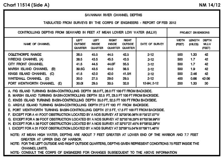
5 SECTION I NM 14/12 CHART CORRECTIONS Ed. 2/11 LAST NM 10/12 14/12 Add Stranded wreck [K24] N W (2(31)12 (SM) Mexico, D.F.) 506 (INT 506) 2Ed. 2/3/96 LAST NM 12/12 14/12 Add Depth 1742 meters enclosed by depth contour (2000-meter) centered N E (NTM0005/2012) 525 3Ed. 2/5/83 LAST NM 12/12 14/12 Add Depth 952 fathoms enclosed by depth contour (1000-fathom) centered N E (NTM0005/2012) Ed. 2/12 NEW EDITION 14/12 (NOS) Ed. 11/09 LAST NM 13/12 14/12 Add Submarine pipeline [L40.1] joining N W N W N W (NOS) Ed. 2/12 NEW EDITION 14/12 Add Submarine pipeline [L40.1] joining N W N W N W (NOS) Ed. 8/11 LAST NM 13/12 14/12 Delete Submerged well (cov 150ft) N W Buoy N W Buoy 3A N W (Supersedes 1/ ) (Inset South Pass) Delete Buoy N W Buoy 3A N W (11/12 CG8) Ed. 7/11 LAST NM 11/12 14/12 Add Submarine pipeline [L40.1] joining N W N W N W (NOS) Ed. 1/12 LAST NM 10/12 14/12 Change Visibility (range) of light 34 to 4M N W Visibility (range) of light 61 to 5M N W Visibility (range) of light 62 to 5M N W (11/12 CG8) Ed. 5/11 LAST NM 13/12 14/12 Delete Legend (awash) at dangerous wreck (PA) N W (See 13/ ) (11/12 CG8) Ed. 2/10 LAST NM 11/12 14/12 (Extension) Add Danger circle Obstn [K40] (PA) N W (NOS) Ed. 4/11 LAST NM 13/12 14/12 Add Submarine pipeline [L40.1] joining N W N W N W (NOS) Ed. 2/12 NEW EDITION 14/12 (NOS) Ed. 6/06 LAST NM 13/12 14/12 Change Legend to 20 FT N W Legend to 20 FT APR N W (NOS) Ed. 8/06 LAST NM 13/12 14/12 Change Legend to 20 FT APR N W (NOS) Ed. 2/12 NEW EDITION 14/12 Add Platform [L10] N W (Previously published 12/12) (NOS) Ed. 10/10 LAST NM 13/12 14/12 Delete Legend (awash) at dangerous wreck (PA) N W (See 13/ ) (11/12 CG8) Ed. 7/11 LAST NM 11/12 14/12 (Side A) Add Danger circle Obstn [K40] (PA) N W (NOS) Ed. 2/12 NEW EDITION 14/12 Change Visibility (range) of light 12 to 5M N W (Previously published 13/12) (NOS) Ed. 4/09 LAST NM 10/12 14/12 Add Tabulation of controlling depths from Subsection I-2 (Supersedes 10/ ) (NOS) Ed. 2/12 NEW EDITION 14/12 Delete Buoy BH N W (Previously published 13/12) (NOS) Ed. 12/09 LAST NM 13/12 14/12 Delete Legend (awash) at dangerous wreck (PA) N W (See 13/ ) (11/12 CG8) Ed. 2/10 LAST NM 13/12 14/12 Add Tabulation of controlling depths from Subsection I-2 (See 10/ ) (NOS) Ed. 7/11 LAST NM 11/12 14/12 Add Submarine pipeline [L40.1] between N W N W (NOS) Ed. 10/08 LAST NM 13/12 14/12 (Side A) Add Tabulation of controlling depths from Subsection I-2 (Supersedes 10/ ) (NOS) Ed. 5/11 LAST NM 13/12 14/12 Delete Legend (awash) at dangerous wreck (PA) N W (See 13/ ) (11/12 CG8) I-1.1
6 NM 14/12 SECTION I Ed. 8/06 LAST NM 9/12 14/12 Add Solid line (pier) [F14] between N W N W Ed. 2/12 NEW EDITION 14/12 (NOS) (NOS) Solid line (pier) [F14] between N W N W Ed. 5/11 LAST NM 31/11 14/12 Delete Buoy A N W (11/12 CG1) Ed. 1/10 LAST NM 12/12 14/12 (Side A) Add Light 1 Fl G 2.5s 16ft 5M N W Add (Side B) Solid line (pier) [F14] between N W N W Solid line (pier) [F14] between N W N W (NOS; 12/12 CG7) Ed. 12/11 LAST NM 12/12 14/12 Add Light 1 Fl G 2.5s 16ft 5M N W (12/12 CG7) Ed. 2/12 NEW EDITION 14/12 (NOS) Ed. 10/08 LAST NM 33/11 14/12 (Side A) Change Legend to 23 1 / 2 FT N W Legend to 27 FT N W (NOS) Ed. 5/12/01 LAST NM 47/10 14/12 Add Tabulation of controlling depths from Subsection I-2 (Supersedes 47/ ) (NOS) Ed. 8/08 LAST NM 33/11 14/12 Change Legend to 23 1 / 2 FT N W Legend to 27 FT N W (NOS) Ed. 6/10 LAST NM 51/11 14/12 Change Buoy A to 154 Y, Fl(5) Y 20s (Priv) N W (See 51/ ) (11/12 CG1) Ed. 4/29/06 LAST NM N51/11 N14/12 Change Buoy A to 154 Y, Fl(5) Y 20s (Priv) N W (See N51/ ) (11/12 CG1) Ed. 8/09 LAST NM 10/12 14/12 Delete Buoy A N W Buoy B N W Buoy C N W Buoy D N W (10/12 CG5) Ed. 2/12 NEW EDITION 14/12 (NOS) Ed. 5/10 LAST NM 12/12 14/12 Change Buoy A to 154 Y, Fl(5) Y 20s (Priv) N W (See 51/ ) (11/12 CG1) Ed. 8/06 LAST NM 51/11 14/12 Delete Fish haven area and buoys (4) in vicinity N W (11/12 CG1) Ed. 7/04 LAST NM 28/11 14/12 Delete Fish haven area and buoys (4) in vicinity N W (11/12 CG1) Ed. 8/06 LAST NM 40/11 14/12 Add Buoy Fl(5) Y (Priv) N W (11/12 CG9) Ed. 12/17/04 LAST NM N16/08 N14/12 Add Dangerous submerged rock [K13] N W Dangerous submerged rock [K13] N W (5(7791)10 Ottawa) Ed. 7/08 LAST NM 31/11 14/12 Add Purple dashed line (security zone) [N1.2] joining N W N W N W N W (NOS) Caution note NOTE D CAUTION Mariners are advised that low flying aircraft may be present over Hog Island Channel in the vicinity of Dutch Harbor Airport. The Federal Aviation Administration (FAA) has requested that vessels transit with caution and not anchor within the area N W Legend see note D N W Ed. 5/10 LAST NM 42/11 14/12 Add Purple dashed line (security zone) [N1.2] joining N W N W N W N W (NOS) Caution note NOTE B CAUTION Mariners are advised that low flying aircraft may be present over Hog Island Channel in the vicinity of Dutch Harbor Airport. The Federal Aviation Administration (FAA) has requested that vessels transit with caution and not anchor within the area N W Legend see note B N W Ed. 2/12 NEW EDITION 14/12 (NOS) Ed. 3/16/02 LAST NM 31/08 14/12 Relocate Light from N W to N W (10/12 CG17) Ed. 4/09 LAST NM 12/12 14/12 Change Buoy A to 154 Y, Fl(5) Y 20s (Priv) N W (See 51/ ) (11/12 CG1) I Ed. 6/02 LAST NM 27/09 14/12 Relocate Light from N W to N W (10/12 CG17)
7 SECTION I NM 14/ Ed. 2/12 NEW EDITION 14/12 (NOS) Ed. 6/07 LAST NM 13/11 14/12 Change Legend to 10 FT JUL N W (NOS) Ed. 6/27/03 LAST NM N11/12 N14/12 Delete Depth 6.7 meters N W Depth 12 meters N W Depth 11.9 meters N W Range beacons (2), range line and legend (DND/MDN) between N W N W (See N16/ ) Ed. 9/09 LAST NM 8/12 14/12 Delete Dashed line (channel limit) between N W N W Dashed line (channel limit) between N W N W Dashed line (channel limit) between N W N W Dashed line (channel limit) between N W N W Dashed line (channel limit) between N W N W Relocate Buoy (mooring) from N W to N W Buoy (mooring) from N W to N W Add Depth 12.4 meters N W Depth 12.1 meters N W Depth 13.5 meters N W Buoy (mooring) [Q40] (Priv) N W Pontoon [F16] joining Light FR Light FR Light FR Light FR (5, 9(3419)10 Ottawa) N W N W N W N W N W N W N W Crane symbol [F53.1] with legend R Lts N W N W Ed. 12/09 LAST NM 9/12 14/12 Delete Dashed line (channel limit) between N W N W Add (NOS) Dashed line (channel limit) [I20] between N W N W and delete all hydrography between existing channel limit and above dashed line Dashed line (channel limit) [I20] joining N W N W N W N W and delete all hydrography between existing channel limit and above dashed line except depth 46 close to light B Dashed line (channel limit) [I20] between N W N W and delete all hydrography between existing channel limit and above dashed line Dashed line (channel limit) [I20] between N W N W and delete all hydrography between existing channel limit and above dashed line Dashed line (channel limit) [I20] joining N W N W N W N W and delete depth 42 feet close to light B Dashed line (channel limit) between N W N W Dashed line (channel limit) between N W N W Dashed line (channel limit) between N W N W Ed. 2/11 LAST NM 8/12 14/12 (Page A) Delete Dashed line (channel limit) between N W N W Change Legend to 44 FT MAY N W Legend to INNER HBR ENT CHAN 46 FT N W Add Dashed line (channel limit) [I20] between N W N W Legend to BAR CHAN 48 FT N W (See 33/ ) Dashed line (channel limit) [I20] between N W N W (Page B, Inset 5) Dashed line (channel limit) between N W N W Dashed line (channel limit) between N W N W Dashed line (channel limit) between N W N W (continued on next page) (NOS) Dashed line (channel limit) [I20] between N W N W and delete depths 46 and 47 feet between existing channel limit and above dashed line Dashed line (channel limit) [I20] between N W N W Dashed line (channel limit) [I20] joining N W N W N W N W Add Delete I-1.3
8 NM 14/12 SECTION I (Continued) Change Legend to INNER HBR CHAN 46 FT MAY N W Legend to 48 FT MAY 2011 BAR CHANNEL N W Ed. 2/26/11 LAST NM N35/11 N14/12 Change Visibility (range) of light to 20M N W (3(206)12 Taunton) Add Dashed line (channel limit) [I20] between N W N W Ed. 8/7/93 LAST NM 53/11 14/12 Change Light to Fl 7.5s 80m 19M N W (3(206)12 Taunton) (NOS) Dashed line (channel limit) [I20] between N W N W Dashed line (channel limit) [I20] between N W N W Ed. 12/26/81 LAST NM 10/12 14/12 Change Visibility (range) of light to 30M N W (See 10/ ) (Mex LL) Ed. 3/3/84 LAST NM 50/10 14/12 Add Light Fl(2) 10M N W (Mex LL) Ed. 10/29/94 LAST NM 45/10 14/12 Change Light to Fl 7.5s 80m 19M N W Light to Fl 4s 7m 9M N W (3(206)12 Taunton) Ed. 10/29/94 LAST NM 29/10 14/12 Change Light to Fl 4s 7m 9M N W (See 8/ ) (3(206)12 Taunton) Ed. 5/23/87 LAST NM 47/11 14/12 Change Visibility (range) of light to 25M N W (3(206)12 Taunton) Ed. 10/29/94 LAST NM 37/10 14/12 Change Characteristic of light to Fl 3s N W Ed. 11/26/94 LAST NM 50/10 14/12 Change Legend to Lts in line N W Change (Plan B) Characteristic of light to Fl 3s N W Add Light Fl(2) 10s 30m 10M N W (Plan) Change Legend to Lts in line N W Add Light to Fl G 5s 13m 9M Light to Fl R 5s 13m 9M (See 31/ ) N W N W Range light, front Fl 3s 7m 5M N W Range light, rear Iso 2s 10m 5M N W Range line extending in 180 direction from above rear light dashed for 315 meters, thence solid for 2450 meters Legend Lts in line 000 along above range line N W Range light, front Fl 3s 7m 5M N W Range light, rear Iso 2s 10m 5M N W Range line extending in 180 direction from above rear light dashed for 355 meters, thence solid for 2410 meters Legend Lts in line 000 along above range line N W Light Iso R 2s Light Iso R 2s Light Iso R 2s (NGA; Mex LL) N W N W N W Ed. 11/29/97 LAST NM 49/10 14/12 Add Purple dashed line (harbor limit) [N49] joining S W S W S W S W S W (2(20)12 Valparaiso; Chile CH 11500) Ed. 2/7/04 LAST NM 35/11 14/12 Change Visibility (range) of light to 20M N W (3(206)12 Taunton) (See 26/ ) (3(206)12 Taunton) Ed. 10/29/94 LAST NM 45/11 14/12 Change Light to Fl(3) 15.5s 168m 25M N W (3(206)12 Taunton) Ed. 11/26/94 LAST NM 53/11 14/12 Change Visibility (range) of light to 25M N W (See 12/ ) (3(206)12 Taunton) Ed. 6/17/95 LAST NM 48/11 14/12 Change Light to Fl 15s 24m 12M N W (Supersedes 14/ ) (35/12 Bogota) Ed. 11/18/06 LAST NM 48/11 14/12 Change Light to Fl 15s 24m 12M N W (Supersedes 14/ ) (35/12 Bogota) Ed. 5/1/10 LAST NM 8/12 14/12 Change Light to Fl 15s 24m 12M N W (Supersedes 14/ ) (35/12 Bogota) Ed. 4/24/10 LAST NM 8/12 14/12 Change Light to Fl 15s 12M N W (Supersedes 14/ ) (35/12 Bogota) Ed. 2/7/04 LAST NM 35/11 14/12 Change Visibility (range) of light to 20M N W (3(206)12 Taunton) Ed. 7/4/92 LAST NM 10/12 14/12 Add Stranded wreck [K24] N W (2(31)12 (SM) Mexico, D.F.) Ed. 8/22/98 LAST NM 52/11 14/12 Add Stranded wreck [K24] N W (2(31)12 (SM) Mexico, D.F.) I-1.4
9 SECTION I NM 14/ Ed. 2/21/98 LAST NM 16/04 14/12 (Plan A) Add Dangerous wreck [K28] (PA) N W Ed. 2/2/08 LAST NM 13/12 14/12 Delete Depth 33 meters Wk N E (3(37)12 Tallinn) (Plan B) Add Stranded wreck [K24] N W (2(30, 31)12 (SM) Mexico, D.F.) Ed. 1/30/99 LAST NM 9/12 14/12 Add Dangerous wreck [K28] (PA) N W (2(30)12 (SM) Mexico, D.F.) Ed. 12/7/91 LAST NM 9/12 14/12 Add Dangerous wreck [K28] (PA) N W Stranded wreck [K24] N W (2(30, 31)12 (SM) Mexico, D.F.) Ed. 10/19/96 LAST NM 2/12 14/12 Add Depth 100 meters Wk [K26] N W (10(1055)12 Taunton) (INT 1503) 2Ed. 12/30/04 LAST NM N5/12 N14/12 Add Depth 100 meters Wk [K26] N W (10(1055)12 Taunton) Ed. 2/10/95 LAST NM N51/06 N14/12 Change Light to Fl WR 5s 11/9M N W (14/11 Dublin) Ed. 2/17/05 LAST NM N47/11 N14/12 Add Depth 22 meters Obstn [K41] N E (See 2/ ) (7(732)12 Taunton) Ed. 7/19/08 LAST NM 13/12 14/12 Add Depth 22 meters Obstn [K41] N E (7(732)12 Taunton) Ed. 1/30/99 LAST NM 3/11 14/12 (Panel A) Add Chartlet, depicting changes in hydrography, topography and aids to navigation, from Subsection I N E (3(42274)12 Stavanger; Nor CH 480) Ed. 10/3/09 LAST NM 12/12 14/12 Substitute Depth 33 meters Wk [K26] for 32 meters Wk N E (1(3)12 Gdynia) Ed. 3/10/07 LAST NM N13/12 N14/12 Delete Light (Fl G 4s 8m 2M) N E Depth 33.5 meters Wk N E (3(34, 37)12 Tallinn) Ed. 3/20/10 LAST NM N18/11 N14/12 Delete Position circle Pile N E Add Depth 5.9 meters Obstn [K41] N E (12(1697)12 St. Petersburg) Ed. 1/23/10 LAST NM 9/12 14/12 Add Buoy YB, spar, double cone topmark points downward N E Buoy YBY, spar, double cone topmark points together N E (5(62, 63)11 Tallinn) Ed. 7/3/10 LAST NM 34/11 14/12 Add Light (AERO) [P60] Fl RW 3s 56m 12/5M N E (3(63)12 Riga) Ed. 5/15/10 LAST NM 5/12 14/12 Add Depth 68 meters Wk [K26] N E (50(926)11 Gdynia) Ed. 10/3/09 LAST NM N36/11 N14/12 Add Light (AERO) [P60] Fl RW 3s 56m 12/5M N E (3(63)12 Riga) Ed. 1/11/97 LAST NM 12/12 14/12 Add Depth 56 meters Wk [K26] N E Depth 68 meters Wk [K26] N E (50(926)11 Gdynia) Ed. 7/2/11 LAST NM N4/12 N14/12 (Panel A) Delete Light N E Light N E Double solid line and land tint between N E N E (50(924)11, 1(1)12 Gdynia) Ed. 4/6/96 LAST NM 34/11 14/12 (Plan) Add Land tint to area bound by shore and solid line [F13] joining N E N E N E N E and delete all hydrography within above area Light Oc(2) R 8s 6m 2M N E Light Oc(2) R 8s 6m 2M N E Light QG 7m 3M N E (50(931)11 Gdynia) Ed. 3/13/10 LAST NM 12/12 14/12 Substitute Depth 33 meters Wk [K26] for 32 meters Wk N E (1(3)12 Gdynia) Ed. 9/21/96 LAST NM 9/12 14/12 Add Buoy YBY, spar, double cone topmark points together N E Buoy YB, spar, double cone topmark points downward N E (5(62, 63)11 Tallinn) Ed. 4/16/11 LAST NM N12/12 N14/12 Add Light Fl R 6s 7m 4M N E Light Fl G 6s 7m 4M N E Depth 56 meters Wk [K26] N E (50(923, 926)11 Gdynia) Ed. 3/26/11 LAST NM N12/12 N14/12 Add Depth 56 meters Wk [K26] N E Depth 68 meters Wk [K26] N E (50(926)11 Gdynia) Ed. 2/22/97 LAST NM 12/12 14/12 Substitute Depth 33 meters Wk [K26] for 32 meters Wk N E (1(3)12 Gdynia) Ed. 8/10/02 LAST NM 35/11 14/12 (Plan) Add Buoy YB, pillar, double cone topmark points downward, VQ(6) + L Fl 10s [Q130.3] N E (7(39)12 Istanbul) I-1.5
10 NM 14/12 SECTION I Ed. 5/18/96 LAST NM 29/11 14/12 Delete Dashed line and legend ISTANBUL HARBOR joining N E N E N E N E Ed. 2/1/03 LAST NM N12/12 N14/12 Add Platform with light flare symbol [L10] N E Platform with light flare symbol [L10] N E Platform with light flare symbol [L10] N E Add Purple dashed line (harbor limit) [N49] between N E N E Platform with light flare symbol [L10] and Racon (G) N E Legend ISTANBUL HARBOR LIMIT between N E N E Danger circle Well [L21.1] (30(3278)11 Taunton; UKHO ARCS ) N E Legend SILE HARBOR LIMIT between N E N E (7(36)12 Istanbul) Ed. 3/1/03 LAST NM 10/12 14/12 Add Dangerous wreck [K28] Rep (2011) N E (NTM0010/2012) Ed. 9/21/96 LAST NM 13/12 14/12 Relocate Buoy 1 from N E to N E (12(1717)12 St. Petersburg) Ed. 1/14/95 LAST NM 10/12 14/12 Add Dangerous wreck [K28] Rep (2011) N E (NTM0010/2012) Ed. 1/23/99 LAST NM 12/12 14/12 Delete Dashed line and legend ISTANBUL HARBOR joining N E N E N E N E (7(36)12 Istanbul) Ed. 3/12/05 LAST NM 6/12 14/12 Add Light Fl R 1.5s 1M N E Light Fl G 1.5s 1M N E (12(1721)12 St. Petersburg) Ed. 3/19/05 LAST NM 9/12 14/12 Add Buoy 1 G, pillar, cone topmark, Fl G 3s N E Buoy 3 G, pillar, cone topmark, Fl G 3s N E (12(1720)12 St. Petersburg) Ed. 8/31/96 LAST NM 12/12 14/12 Delete Dashed line and legend ISTANBUL HARBOR joining N E N E N E N E (7(36)12 Istanbul) Ed. 8/23/97 LAST NM 36/08 14/12 Change Characteristic of light to Fl S E Characteristic of light to Iso WRG S E (9(892)12 Taunton) Ed. 1/17/98 LAST NM 22/98 14/12 Change Characteristic of light to Fl 6s S E Light to Iso WRG 2s 11m 10/7M S E (9(892)12 Taunton) Ed. 6/27/92 LAST NM 5/99 14/12 Change Characteristic of light to Fl 6s S E (9(892)12 Taunton) Ed. 2/1/03 LAST NM 12/12 14/12 Add Platform with light flare symbol [L10] N E Platform with light flare symbol [L10] N E Platform with light flare symbol [L10] N E Platform with light flare symbol [L10] and Racon (G) N E Danger circle Well [L21.1] (30(3278)11 Taunton; UKHO ARCS ) N E I Ed. 3/1/03 LAST NM 11/12 14/12 Add Platform Barzan-1 with light flare symbol [L10] N E Platform Barzan-2 with light flare symbol [L10] N E Platform Barzan-3 with light flare symbol [L10] N E Platform AS-G with light flare symbol [L10] and Racon (G) N E Danger circle Well [L21.1] (30(3278)11 Taunton; UKHO ARCS ) N E Ed. 3/1/03 LAST NM 12/12 14/12 Add Platform Barzan-1 with light flare symbol [L10] N E Platform Barzan-2 with light flare symbol [L10] N E Platform Barzan-3 with light flare symbol [L10] N E Platform AS-G with light flare symbol [L10] and Racon (G) N E Danger circle Well [L21.1] (30(3278)11 Taunton; UKHO ARCS ) N E Ed. 3/15/03 LAST NM 10/12 14/12 Add Platform Barzan-1 with light flare symbol [L10] N E Platform Barzan-2 with light flare symbol [L10] N E Platform Barzan-3 with light flare symbol [L10] N E Platform AS-G with light flare symbol [L10] and Racon (G) N E (30(3278)11 Taunton; UKHO ARCS ) Ed. 3/15/03 LAST NM N10/12 N14/12 Add Platform Barzan-1 with light flare symbol [L10] N E Platform Barzan-2 with light flare symbol [L10] N E Platform Barzan-3 with light flare symbol [L10] N E Platform AS-G with light flare symbol [L10] and Racon (G) N E (30(3278)11 Taunton; UKHO ARCS ) Ed. 3/8/03 LAST NM 11/12 14/12 Add Platform Barzan-1 with light flare symbol [L10] N E Platform Barzan-2 with light flare symbol [L10] N E Platform Barzan-3 with light flare symbol [L10] N E Platform AS-G with light flare symbol [L10] and Racon (G) N E (30(3278)11 Taunton; UKHO ARCS )
11 SECTION I NM 14/ Ed. 3/8/03 LAST NM N11/12 N14/12 Add Platform Barzan-1 with light flare symbol [L10] N E Platform Barzan-2 with light flare symbol [L10] N E Platform Barzan-3 with light flare symbol [L10] N E Platform AS-G with light flare symbol [L10] and Racon (G) N E (30(3278)11 Taunton; UKHO ARCS ) Ed. 2/22/03 LAST NM 50/10 14/12 Add Platform Barzan-1 with light flare symbol [L10] N E Platform Barzan-2 with light flare symbol [L10] N E Platform Barzan-3 with light flare symbol [L10] N E Platform AS-G with light flare symbol [L10] and Racon (G) N E (30(3278)11 Taunton; UKHO ARCS ) Submarine cable [L30.1] joining N E N E N E N E N E N E N E N E N E N E (3(60)12 Dehra Dun) Ed. 8/30/97 LAST NM 37/11 14/12 Change Characteristic of light to Fl 5s N E (Supersedes 37/ ) (2(26)12 Manila) Ed. 6/24/95 LAST NM 37/11 14/12 Change Characteristic of light to Fl 5s N E (Supersedes 37/ ) (2(26)12 Manila) Ed. 9/20/08 LAST NM 11/12 14/12 Add Buoy R, pillar with legend Rep (2012) N E Buoy W, can, cone topmark with legend Rep (2012) N E Legend (Rep missing 2012) to buoy N E (NTM0010/2012, NTM0011/2012) Ed. 9/20/08 LAST NM 23/11 14/12 Add Light Fl 5s 7M N E (2(26)12 Manila; UKHO LL) Ed. 8/16/86 LAST NM 48/11 14/12 Delete Light N E Add Light Fl 5s 15m 9M N E (11(231)11 Manila; UKHO LL) Ed. 9/20/08 LAST NM N11/12 N14/12 Add Buoy R, pillar with legend Rep (2012) N E Buoy W, can, cone topmark with legend Rep (2012) N E Legend (Rep missing 2012) to buoy N E (NTM0010/2012, NTM0011/2012) Ed. 12/9/89 LAST NM 47/11 14/12 Add Light Fl R 5s 11M N E (11(232)11 Manila; UKHO LL) Ed. 2/17/90 LAST NM 24/11 14/12 Relocate Light from N E to N E Add Visibility (range) 11M to light N E Ed. 5/19/07 LAST NM 9/12 14/12 Change Light to Fl(3) 30s 63m 16M Racon (G) N E Add Light Fl(3) 20s 77m 16M N E (3(61, 62)12 Dehra Dun) (Plan) Delete Light and sector limits N E Add Light Fl G 5s 11m 10M with obscured sector N E (11(232)11 Manila; UKHO LL) Ed. 2/17/96 LAST NM 45/10 14/12 Add Light Fl(3) 20s 77m 16M N E (3(62)12 Dehra Dun) Ed. 6/10/78 LAST NM 40/11 14/12 Add Buoy Y, conical, (Y Lt) N E (2(25)12 Manila) Ed. 5/2/09 LAST NM 53/11 14/12 Add Submarine cable [L30.1] joining N E N E N E N E N E N E N E (3(60)12 Dehra Dun) Submarine cable [L30.1] joining N E N E N E N E N E N E N E N E N E Ed. 12/12/98 LAST NM 16/11 14/12 Change Characteristic of light to F N E Characteristic of light to F N E Characteristic of light to F N E (UKHO LL) Ed. 6/17/06 LAST NM 5/12 14/12 Add Dangerous wreck [K28] (PA) N E (34(1081)07 Tianjin) Ed. 5/25/96 LAST NM 22/11 14/12 (Panel B) Add Dangerous wreck [K28] (PA) N E (34(1081)07 Tianjin) Ed. 10/6/11 NEW EDITION N14/12 (NGA) Ed. 1/31/09 LAST NM N46/11 N14/12 Add Submarine cable [L30.1] joining N E N E N E N E N E N E N E I-1.7

12 SECTION I NM 14/12 I-2.1

13 SECTION I NM 14/12 I-2.2

14 SECTION I NM 14/12 I-2.3

15 SECTION I NM 14/12 I-2.4
16 SECTION I NM 14/12 CHARTS AFFECTED BY NOTICE TO MARINERS NM 52/11 THROUGH NM 14/12 Note: N indicates Not For Sale; P indicates Preliminary; T indicates Temporary; * indicates New Edition/New Chart; ** indicates Chart Canceled Chart Ed. Notice to Mariners / / / / / / / / / ,8,13/ / / / ,10,14/ /11;3,7,10/ / ,14/ / / / / / ,12/ ,14/ ,12/ / ,13/ / / / / / / / A 6/ A 8,9,11,13/ A 52,53/11;2,6,7,8,9,11,12, 13/ A 52,53/11;8,9,12/ /11;7,8,9,11/ / / /12* ,53/11;8,9,12/ / N3/ / / / N3/ / / /11;13,14/ ,9,13/ ,9,13/ *,11/ ,11,13/ ,9,11,13/ ,9,13/ ,53/11;6,9,11/ /12* ,9,11,14/ ,53/11;2,6,7,8,9,11,12, 13/ ,12,13,14/ ,12,13/ /12* / ,13,14/ ,9,11,14/ / ,11/ ,11/ ,14/ /11;11,14/ ,53/11;2,7,11/ ,53/11;1,7,9,11,13, 14/ ,2,3,8,9,11/ ,9,11,13/ ,53/11;1,11,13,14/ N8,N9,N11,N13/ /11;11,14/ *,14/ ,8,9,11,13,14/ / /12* Chart Ed. Notice to Mariners *,12/ ,3,6,8,9,11/ /12* /12* /11;1,13/ /11;1,13/ ,3,12,13/ /11;13/ / ,12/ ,12/ / / / ,13,14/ ,13,14/ /12* / N6/ ,5,11/ ,6/ N5,N6/ ,6/ / / / / / / ,9/ / / / / /11*;9/ / / *,11/ / / N10/ / N10/ ,10,11,13/ N10/ ,9/ /11;9,12/ / N52/ N3,N6,N10,N11,N12, N13/ ,12,13/ /11;4,13/ / ,10/ ,14/ /11;3,9/ /12* /11;13/ ,4,9,10,13,14/ /11;3,6,12/ ,10,13,14/ /11;6,9,14/ ,9,12/ /11;5,9,12,14/ ,5,10,12/ ,12/ / / *,12,14/ N5,N10/ /12* /11;9,10,12/ ,10,11/ /12* ,10/ ,11/ /12* / / /12* ,5,10,11/ N1,N5,N10,N11/ ,10/ / / *,11/12 Chart I-3.1 Ed. Notice to Mariners / / / ,8,10,11/ ,11/ ,8,11/ /12* / ,7,11/ / / / ,8/ / / ,10/ / / / ,7,11/ ,7/ /11*;11/ / ,10,11/ / / /12* / / *,11/ / / / / / N14/ ,10/ ,10,14/ /12* / / / / /11;1,9,10,13/ ,10/ ,10/ /11;1,9,10/ ,9/ / / / /12* ,10,11/ ,11/ / ,9/ / / ,3,7,10/ /12* / / N1,N12/ ,5,7,11,12,14/ ,7,12,14/ ,7,12/ / N12/ / ,9,10/ / / ,7,10/ / ,9/ ,8,9/ *,9/ /11;2,7,8,13/ /12* / ,12/ / /12* *,12/ / ,7,12/ N1,N7,N12/12 Chart Ed. Notice to Mariners / / / / / / /12* *,13/ ,13/ / *,13/ / / ,12/ ,7/ / / / / / / / / / ,2/ / / / / /11;2/ / / / / / / /11;11/ / / N9/ N9/ N13/ N14/ N12/ N7/ N7/ N11/ N11/ N13/ N9,N13/ N12/ N12/ N12/ N12/ N7/ / / / ,4/ /12* ,4/ / / / /12* /12* /12* /12* / N11/ /12* /12* /12* / /12* /12* /12* /11;8,9/ /11;8,9/ N11/ N11/ / N11/ N11/ N11,N13/ ,8/ N8/12
17 NM 14/12 SECTION I CHARTS AFFECTED BY NOTICE TO MARINERS NM 52/11 THROUGH NM 14/12 Note: N indicates Not For Sale; P indicates Preliminary; T indicates Temporary; * indicates New Edition/New Chart; ** indicates Chart Canceled Chart Ed. Notice to Mariners Chart Ed. Notice to Mariners Chart Ed. Notice to Mariners Chart Ed. Notice to Mariners N11/ N7,N11/ N8,N11/ N9/ N9/ N9/ N11,N13/ N13/ N3,N13/ N13/ /11;10,11/ N52/11;N10/ ,5,7,13/ N2,N10/ N7/ ,7,13/ N3,N7/ N2,N10/ ,10/ /12* /11;2,10,11/ ,5,7,8/ N13/ / ,6/ /11*;4,5,6,8,10,12/ / / / / N9,N11/ N9/ N9/ ,4,8,10/ ,8,9,10,12/ ,10/ / ,4,8,10,11/ / ,10/ ,4,8,10/ ,4,8/ N13/ / / / ,5/ N9/ N10/ / ,8,13/ N10,N11,N14/ N13/ ,12/ ,8,9,11/ ,4,8,10,11/ ,11/ / ,3,5,13/ ,11/ ,9,10/ / / / ,10,13/ / / / /12* / / / / / / / / / /12* /12* ,9/ ,9/ ,4,5,8,9,14/ ,5,8,14/ /11;1,4,6,8,14/ ,5/ ,11/ / / / / ,2,9,10/ ,11/ / /11;7,11/ / /11;2,11/ N52/ / / N52/11;N7,N11/ ,6/ N8/ / / / / / N5,N8,N11/ ,8,11/ / / ,11/ / N1/ / / / / N8/ / / N8/ ,14/ / / / / / ,4,5,8,10,11/ ,4,5,8,10,11/ / / N2/ ,10/ N9/ / ,9/ / / / / / / ,5,8,10/ / /11;5/ /11;5/ / / / / / ,8/ / / ,8/ ,8/ ,8/ / / / / / / / / /11;5,9/ /11;5,9/ /11;9/ /11;5,9/ / / /12 I N3/ / / ,8/ / / ,7,8/ / / /11;4/ / /11;3,13/ / N53/ N53/11* N10/12* / N53/11* / N53/ N3/ / ,7/ ,7/ / / N6/ / / N3/12* N53/ ,6,10/ / / / N8,N10/ / N8/ N6/ N6/ / / / ,10/ / N5/ N5/ / / ,13/ N1/ / / / / / ,8/ / / N14/ /11;14/ / / / / / / /11;14/ ,12/ ,12/ / ,6,7,9,13/ ,7,9,10,13/ / / ,14/ ,14/ / / / ,13/ / / /11;5,8,13/ / / / / / /11;1/ / /12* / /12* /12* / / ,12/ / *,8/ /12* / / / / / / N3/ / / / / / / / ,10,14/ / / ,13/ / / N3/12* / / / ,10/ / /11;14/ / /11;9,14/ / / / / ,14/ / ,10/ / / / /12* / / N1/12* N1/12* ,14/ N52/ N8/ N2/12* N3/12* N5*,N14/ N52/ N14/ N10,N13/ N8/ N12/ /12* N53/11;N10,N13/ N53/11;N13/ N13/ N13/12* N2/12* N13/12* N8/ N8/ /11;1,9,10,11/ N5/12* ,9,10,11/ N1*,N8/ / N3/12* / / N5/12*
18 SECTION I NM 14/12 CHARTS AFFECTED BY NOTICE TO MARINERS NM 52/11 THROUGH NM 14/12 Note: N indicates Not For Sale; P indicates Preliminary; T indicates Temporary; * indicates New Edition/New Chart; ** indicates Chart Canceled Chart Ed. Notice to Mariners N14/ N10/ / / / N6,N8/ N1,N2,N8,N13/ N10/ N5,N8/ ,9,11,12,13/ ,11,12,13,14/ /11;9/ N52/ ,12,13/ N8,N12/ ,11,13/ /11;8,12/ N4,N12,N13/ ,13/ ,13/ N4*,N13/ N13/ N2,N4/ / ,13/ N2,N13/ N2,N8,N12,N13/ N53/11*;N2,N13/ N2,N8,N12/ ,53/11;5/ ,6/ / / / ,8/ / / / N52/ / / / N4/ N4/ / / / / ,13/ / N10,N12,N13/ ,53/11;4,8,12/ / / / / / / ,8,9/ / ,9/ / / / / / / / / / / / / / ,8/ ,8/ ,9/ ,13/ ,7,9/ / / N4*,N6,N7,N13/ N7/ /11;2,7/ / ,11/ ,13/12 Chart Ed. Notice to Mariners / / N11/ / ,13/ / / ,6/ / /11;12,14/ ,11,12/ N11/ ,5,11,12/ / N11/ /12** N52/ N52/ N8/12* N12/ ,12/ / / / / / / / / ,12/ ,12/ /11;12,14/ / ,13/ ,9,14/ ,13,14/ N13,N14/ N6,N13/ ,12/ N6,N9/ N14/ / / /11;6,9,14/ N5*,N6,N13/ / / /11;5,14/ N6/ N14/ N5/ /11;1,12,14/ N4,N14/ N2,N4,N5,N12,N14/ N53/11;N2,N4,N5,N12, N14/ ,14/ / / / / / N8/ N8/ / / / N8,N12/ N8/ / / / N11/ N6/12* ,13/ / / / ,11/ ,11/ ,11,13/ ,13/ / / ,8/ ,11/ /12 Chart I-3.3 Ed. Notice to Mariners ,4,7,8,13/ / ,4/ ,8/ / / ,13/ / N53/11* / N13/ N13/ / ,9/ / / / / / / / / ,9,13/ / / / N5/ ,9/ / /11;7/ / /11;7/ /11;7/ / / / / /11;12/ ,13/ ,6/ N53/ / /11;11/ / / ,4,6,12/ / / / / / / / / / / / / ,6/ ,7/ / / ,8/ ,8,9/ ,9/ / / / /11;9/ / ,11/ / / / ,12/ ,9/ ,13/ / ,9,12,13/ ,11,13/ ,13/ ,7/ ,7/ / / / /11;4,5,7,9,12/12 Chart Ed. Notice to Mariners /11;8/ / ,9/ / / ,14/ ,12,14/ ,14/ ,14/ N13/ / / ,6,7,12,14/ N10,N12/ / / ,10/ / / N9/ ,13/ ,13/ ,12,13/ / ,11/ / ,12/ ,12/ / /11;8,12/ / / / / / / / / / / N1/12* / ,9,11/ ,11,12,14/ N8,N11,N12,N14/ / / / / / ,11/ / / / / / / / / / ,10,14/ / N8/ ,10,14/ /12* ,10,11,14/ ,12,14/ / N8/ ,10,14/ N5,N10,N14/ ,14/ N11,N14/ ,11,12/ N3,N11,N12/ / ,11/ ,14/ N11,N14/ / / / / / ,14/ / /12
19 NM 14/12 SECTION I CHARTS AFFECTED BY NOTICE TO MARINERS NM 52/11 THROUGH NM 14/12 Note: N indicates Not For Sale; P indicates Preliminary; T indicates Temporary; * indicates New Edition/New Chart; ** indicates Chart Canceled Chart Ed. Notice to Mariners / / /11;14/ / N14/ N53/ N53/ N53/ / / ,7/ / / / / / / / / /11;9/ ,6/ / / /11;9/ /11;9/ / / / N7/ / /11;4,5,7,8/ N52/11;N5,N7/ N52/11;N5,N7/ N52/11*;N4,N5,N7/ /11;4,5,7/ N52/11;N7,N8/ N4,N7/ N52/11;N5/ / /11;5,7,9/ N6/12* N4/12* / / / / / / / / / / / / / / / / / / /11;4/ / / /11;6/ / / / / / / / / / / N10/ N10/ N10/ N10/ / N10/ / / / / / / /12 Chart Ed. Notice to Mariners / / N12/ N12/ / / /11;5,10,11,13/ ,5,9,11/ ,5,9,11/ ,8,10,11/ ,11,13/ ,13/ ,11/ / / / / *,9,10/ / / / ,13/ / ,4,8/ N2,N4,N8/ ,8/ / ,10/ ,10/ / / / /11;10,11,12/ /11;3,5,10,11,12/ / / / / / / / / / / / /11;5,7/ / /11;7,10/ N8/12* /11;7/ / / ,11/ ,11/ ,11/ / / / ,13/ / / N5/ /12* /12* / / / *,8/ / / / N53/11;N10,N12/ / / / N12/ N12/ / /11*;5,9/ ,14/ / / / / / / /12 Chart I-3.4 Ed. Notice to Mariners N9/ N6/12* N53/11* / / / ,8/ / ,8/ N8/12* / N13/12* / N6/12* / / N1/12* / / /11;1/ N13/ N1/12* / N2/ N1/ /12** N9/12* N5/12** N5/12* /12** N5/12* N53/ / / / / / / N5/12* N12/12* N9/12** N9/12** N9/12* N9/12* / /11** / N52/11* N3/12* /12** /12** / N6/12* N53/ /12** N14/12* N13/12* N6/12* N3/12* N6/12* N6/ N13/12* /11;6/ /12** N6/ / /11;6/ / /12** / /11;6/ N53/ / N13/12** / /11* / /12** N4/12* N53/ N53/11;N11/ N6/ N10/ N5/12* N13/ N5/12* N3/12* Chart Ed. Notice to Mariners N5*,N13/ N8/ N2/ N53/ N1,N2/ N8/12
20 SECTION II NM 14/12 NGA/DLIS CATALOG CORRECTIONS Note: Underlining indicates that column in which a correction has been made or new information added. Edition NGA Ref. (National Stk. ) Title Scale = 1: Date Price Category NTM REGION 1 11ACO11013 ( ) 11AHA11332 ( ) 11BCO11344 ( ) 11XHA11374 ( ) 11AHA11416 ( ) 11BCO11509 ( ) 11BCO11535 ( ) 12XHA12378 ( ) 13AHA13223 ( ) 16BCO16587 ( ) 17XHA17311 ( ) Straits of Florida 1,200, /12 NOS 14/12 Sabine Bank 80, /12 NOS 14/12 Rollover Bayou to Calcasieu Pass 80, /12 NOS 14/12 Dauphin Island to Dog Keys Pass 40, /12 NOS 14/12 Tampa Bay 40, /12 NOS 14/12 Insets: Tampa 20,000 St. Petersburg 20,000 Safety Harbor 80,000 Tybee Island to Doboy Sound 80, /12 NOS 14/12 Little River Inlet to Winyah Bay Entrance 80, /12 NOS 14/12 Connecticut River-Bodkin Rock to Hartford 20, /12 NOS 14/12 Newport Harbor 20, /12 NOS 14/12 Semidi Islands and Vicinity 135, /12 NOS 14/12 Holkham Bay and Tracy Arm 40, /12 NOS 14/12 Inset: Tracy Arm 20,000 REGION 9 97AHA97319 ( ) Jpn. W1262, Eastern Part of Kanmon Ko 15, /11 JCG 14/12 MISCELLANEOUS CHARTS AND PUBLICATIONS DNCDX015 ( ) Gulf of Mexico/Straits of Florida 34 1/12 DS 14/12 COMDTM ( ) Atlantic and Gulf Coast (Little River, South Carolina to Econfina River, Florida includes Puerto Rico and the U.S. Virgin Islands) 2012 GPO 14/12 COMDTM ( ) COMDTM ( ) Mississippi River System 2012 GPO 14/12 Pacific Coast and Pacific Islands 2012 GPO 14/12 COMDTM ( ) Great Lakes and the St. Lawrence River above the St. Regis River 2012 GPO 14/12 Price Categories effective 1 October 2011 A E G 6.75 D F H II-1.1
21 NM 14/12 SECTION II NGA/DLIS CATALOG CORRECTIONS CHS Canadian Hydrographic Service DS Distribution Limited GPO Government Printing Office NOS National Ocean Service UKHO United Kingdom Hydrographic Office DHO Danish Hydrographic Office AHS Australian Hydrographic Service JCG Japan Coast Guard * Not for sale or reproduction outside U.S.A. To locate the nearest FAA Sales Agents in your area, go to: Note: New editions cancel former editions. They include corrections published in the Notice to Mariners prior to the effective date of the new editions and/or important corrections from other sources. Mariners are warned against the use of obsolete charts and publications as new editions contain information essential to safe navigation; however, such new editions are not valid until their availability is announced in the weekly Notice to Mariners. DoD users and DoD contractors may direct questions concerning the availability and distribution of announced hardcopy charts to the Defense Logistics Agency (DLA) at or ; DSN ; Fax Civilian users can obtain information about ordering NGA paper charts at: II-1.2
22 SECTION II NM 14/12 NAVIGATION PUBLICATIONS USCG LIGHT LIST VOLUMES I - VII CORRECTIONS VOLUME III Ed 2012 NEW EDITION (USCG) 14/12 VOLUME V Ed 2012 NEW EDITION (USCG) 14/12 VOLUME VI Ed 2012 NEW EDITION (USCG) 14/12 VOLUME VII Ed 2012 NEW EDITION (USCG) 14/12 II-2.1
23 SECTION II CORRECTIONS TO C. G. LIGHT LIST, VOLUME I ATLANTIC COAST, 2011 (1) (2) Name and Location (3) Position (4) Characteristic (5) Height (6) Range (7) Structure (8) Remarks 999 BROAD COVE AQUACULTURE LIGHTS (4) Remove from list ORPC Cobscook Bay Lighted Buoy NE ORPC Cobscook Bay Lighted Buoy SE ORPC Cobscook Bay Lighted Buoy SW OAK BLUFFS FERRY SLIP FOG LIGHT N W Fl W 2.5s White with orange bands N W Fl W 2.5s White with orange bands N W Fl W 2.5s White with orange bands N W STROBE 25 Wharf end dolphin. Shown only when authority vessels are approaching dock in fog. Maintained from June 15 to Sept. 10. SIREN: 1 blast ev 15s (3s bl). * * FERRY SLIP FOG LIGHT N W STROBE 22 On Roof. Shown only when authority vessels approach dock in fog. * * FERRY SLIP 1 LIGHT N W F G 14 Marks ferry slip Pine Creek Point Lighted Buoy 22 On south point of shoal N W Fl R 4s 4 Red. Channel buoys 2 through 13 are located 75 feet outside channel limit Entrance Channel Lighted Buoy N W Fl R 2.5s 3 Red. * Basin Coast Guard Mooring Buoy N W ENTRANCE LIGHT N W White nun with blue stripe, marked "CG". Fl R 2.5s 14 3 TR on spindle. 14/12 CORRECTIONS TO C. G. LIGHT LIST, VOLUME II ATLANTIC COAST, 2011 (1) (2) Name and Location (3) Position (4) Characteristic (5) Height (6) Range (7) Structure (8) Remarks Buoy 15A N W Green can South Ferry Terminal Lighted Buoy 3SF N W Fl G 2.5s 4 Green. * Channel Buoy 11B N W Green can. 14/ LIGHT 11WB N W Fl G 2.5s 15 3 SG on pile. Note: Asterisks (*) indicate that column(s) in which a correction has been made or new information added. Denotes a new entry when preceding the station number. II-3.1
24 SECTION II CORRECTIONS TO C. G. LIGHT LIST, VOLUME II ATLANTIC COAST, 2011 (1) (2) Name and Location (3) Position (4) Characteristic (5) Height (6) Range (7) Structure (8) Remarks Lighted Buoy N W Fl G 4s 4 Green. SUMMARY OF CORRECTIONS TO C. G. LIGHT LIST, VOLUME III ATLANTIC AND GULF COAST, 2012 (1) (2) Name and Location (3) Position (4) Characteristic (5) Height (6) Range (7) Structure (8) Remarks 38 CCOOPS Lighted Buoy A Remove from list. * 8/ CCOOPS Lighted Buoy B Remove from list. * 8/ Capers Island Lighted Buoy C N W Charleston Entrance Lighted Buoy C North Edisto River Entrance Lighted Whistle Buoy 2NE Fl Y 4s Yellow. * N W N W Mo (A) W 6 Red and white stripes with red spherical topmark. RACON: K ( ). * 12/12 Fl R 4s 5 Red. * 4/ CCOOPS Lighted Buoy D Remove from list. * 8/ Fripp Island Lighted Buoy E N W Port Royal Sound Lighted Whistle Buoy P 425 Georgia Fish Haven Buoy L Wassaw Sound Lighted Buoy 2W Georgia Fish Haven Buoy BH Fl Y 4s Yellow. * N W N W 950 ELBOW REEF LIGHT N W Lighted Buoy N W 1805 Murrells Inlet Lighted Buoy N W Channel Lighted Buoy N W Channel Lighted Buoy N W Mo (A) W 5 Red and white stripes with red spherical topmark. * 8/12 Fl R 4s 4 Red. Remove from list. Note: Asterisks (*) indicate that column(s) in which a correction has been made or new information added. Denotes a new entry when preceding the station number. II-3.2 * 12/12 * 10/12 Remove from list. * 12/12 Fl R 2.5s 27 5 TR on skeleton tower on piles. * 6/12 Q R 4 Red. Fl G 4s 5 Green. Q G 4 Green. Fl G 2.5s 4 Green. * * 6/12 * 8/12
25 SECTION II SUMMARY OF CORRECTIONS TO C. G. LIGHT LIST, VOLUME III ATLANTIC AND GULF COAST, 2012 (1) (2) Name and Location (3) Position (4) Characteristic (5) Height (6) Range (7) Structure (8) Remarks Channel Lighted Buoy N W - Channel Lighted Buoy N W - Channel Lighted Buoy N W Lighted Buoy N W Lighted Buoy N W LIGHT N W LIGHT N W Charleston Entrance Lighted Buoy C N W Channel Lighted Buoy N W Channel Lighted Buoy N W Channel Lighted Buoy N W Channel Lighted Buoy N W Channel Lighted Buoy N W 2605 Hog Island Reach Channel Lighted Buoy Hog Island Reach Channel Lighted Buoy N W N W - Lighted Buoy N W Q R 4 Red with yellow square. Q R 4 Red with yellow square. Q G 4 Green with yellow triangle. Fl G 2.5s 5 Green. Q G 4 Green. Fl R 2.5s 12 5 TR on pile. Fl R 6s 16 5 TR on pile. Mo (A) W 6 Red and white stripes with red spherical topmark. * 7/12 * 7/12 * 4/12 * 4/12 RACON: K ( ). * 12/12 Fl R 4s 5 Red. Fl G 6s 5 Green. Fl R 4s 5 Red. Q G 4 Green. Fl G 4s 5 Green. Fl G 2.5s 5 Green. Fl R 2.5s 5 Red. * 11/12 * 11/12 * 12/12 * 12/12 * 11/12 * 11/12 * 12/12 Fl R 2.5s 5 Red with yellow triangle. * 12/12 *2647 ASHLEY RIVER LIGHT N W Fl G 2.5s 16 5 SG-SY on dolphin. 14/ Lighted Buoy N W Fl G 4s 4 Green. * 11/12 Note: Asterisks (*) indicate that column(s) in which a correction has been made or new information added. Denotes a new entry when preceding the station number. II-3.3
26 SECTION II SUMMARY OF CORRECTIONS TO C. G. LIGHT LIST, VOLUME III ATLANTIC AND GULF COAST, 2012 (1) (2) Name and Location (3) Position (4) Characteristic (5) Height (6) Range (7) Structure (8) Remarks Lighted Buoy N W Lighted Buoy N W Lighted Buoy N W Lighted Buoy N W *Add Heading: Upper Cooper River * Daybeacon N W * Daybeacon N W * Daybeacon N W * Daybeacon N W * Daybeacon N W * Daybeacon N W * Daybeacon N W * Daybeacon N W * Daybeacon N W * Daybeacon N W * Daybeacon N W * Daybeacon N W * Daybeacon N W * Daybeacon N W * Daybeacon N W Fl R 4s 5 Red. Fl G 4s 5 Green. * 12/12 Fl R 4s 5 Red. * 11/12 Fl R 4s 5 Red. * 12/12 TR on pile. 6/12 SG on pile. 6/12 TR on pile. 6/12 TR on pile. 6/12 SG on pile. 6/12 SG on pile. 6/12 TR on pile. 6/12 SG on pile. 6/12 TR on pile. 6/12 SG on pile. 6/12 TR on pile. 6/12 TR on pile. 6/12 TR on pile. 6/12 TR on pile. 6/12 SG on pile. 6/12 Note: Asterisks (*) indicate that column(s) in which a correction has been made or new information added. Denotes a new entry when preceding the station number. II-3.4
27 SECTION II SUMMARY OF CORRECTIONS TO C. G. LIGHT LIST, VOLUME III ATLANTIC AND GULF COAST, 2012 (1) (2) Name and Location (3) Position (4) Characteristic (5) Height (6) Range (7) Structure (8) Remarks * Daybeacon N W * Daybeacon N W * Daybeacon N W * Daybeacon N W * Daybeacon N W * Daybeacon N W * Daybeacon N W APPROACH RANGE FRONT LIGHT - APPROACH RANGE REAR LIGHT - Entrance Lighted Whistle Buoy 2NE N W - Lighted Whistle Buoy P N W Channel Lighted Buoy N W Channel Lighted Buoy N W Lighted Bell Buoy N W Port Royal Sound Lighted Buoy N W Lighted Bell Buoy N W PARRIS ISLAND SPIT LIGHT N W - Lighted Buoy N W Fl R 4s 5 Red. TR on pile. TR on pile. SG on pile. TR on pile. TR on pile. SG on pile. SG on pile. Remove from list. Remove from list. 6/12 6/12 6/12 6/12 6/12 6/12 6/12 * 11/12 * 11/12 * 4/12 Mo (A) W 5 Red and white stripes with red spherical topmark. * 8/12 Fl R 2.5s 5 Red. Fl R 4s 5 Red. Fl G 4s 5 Green. Fl G 6s 5 Green. Q R 4 Red. Fl R 4s 16 5 TR-TY on dolphin. * 5/12 * 4/12 * 8/12 * 7/12 * 7/12 * * 8/12 Q G 4 Green with yellow triangle. * 4/12 Note: Asterisks (*) indicate that column(s) in which a correction has been made or new information added. Denotes a new entry when preceding the station number. II-3.5
28 SECTION II SUMMARY OF CORRECTIONS TO C. G. LIGHT LIST, VOLUME III ATLANTIC AND GULF COAST, 2012 (1) (2) Name and Location (3) Position (4) Characteristic (5) Height (6) Range (7) Structure (8) Remarks Lighted Buoy N W Lighted Buoy N W Lighted Bell Buoy N W Lighted Buoy N W Lighted Buoy N W Lighted Buoy N W Range Lighted Buoy N W 4855 Elba Island Lighted Buoy N W LIGHT N W LIGHT N W LIGHT N W 4975 Barnwell Island Flats Lighted Buoy FIG ISLAND LIGHT feet outside channel limit ACL TURNING BASIN LIGHT ACL TURNING BASIN LIGHT CITY FRONT CHANNEL LIGHT N W N W N W N W N W - Lighted Buoy 2W N W Lighted Buoy N W Q G 4 Green with yellow triangle. * 4/12 Fl R 4s 5 Red. Q R 4 Red. Q G 4 Green. Fl R 2.5s 5 Red. Fl R 4s 5 Red. Fl R 4s 5 Red. Fl R 4s 5 Red. Fl R 4s 16 5 TR on dolphin. Fl G 4s 16 5 SG on pile. Fl R 4s 16 5 TR on dolphin. Fl R 4s 5 Red. Fl G 4s 16 5 SG on dolphin. Fl R 4s 16 5 TR on pile. Fl R 4s 16 5 TR on pile. Fl R 4s 16 5 TR on pile. Fl R 4s 4 Red. Q R 4 Red. * 8/12 * 8/12 * 8/12 * 8/12 * 8/12 * 8/12 * 8/12 * 6/12 * 6/12 * 8/12 * 5/12 * 12/12 * 12/12 * 12/12 * 12/12 * 10/12 * 13/12 Note: Asterisks (*) indicate that column(s) in which a correction has been made or new information added. Denotes a new entry when preceding the station number. II-3.6
29 SECTION II SUMMARY OF CORRECTIONS TO C. G. LIGHT LIST, VOLUME III ATLANTIC AND GULF COAST, 2012 (1) (2) Name and Location (3) Position (4) Characteristic (5) Height (6) Range (7) Structure (8) Remarks Lighted Buoy N W Lighted Buoy N W Lighted Buoy N W - Lighted Buoy N W Lighted Buoy N W Lighted Buoy N W Lighted Buoy N W Lighted Buoy N W 7490 Dunn Creek Cut Lighted Buoy N W 7495 Dunn Creek Lighted Buoy N W Lighted Buoy N W Cut Lighted Buoy N W Cut Lighted Buoy N W 7975 VERDIERE POINT LIGHT N W 8195 UPPER PALATKA LIGHT N W LIGHT N W 8255 SAN MATEO LIGHT N W LIGHT N W Fl R 4s 5 Red. Fl R 6s 5 Red. * 5/12 Q R 4 Red with yellow triangle. * 7/12 Fl R 2.5s 5 Red with yellow triangle. Fl R 4s 5 Red. Fl G 4s 5 Green. Fl R 4s 5 Red. Fl G 2.5s 5 Green. Fl G 4s 5 Green. Fl G 4s 5 Green. Fl G 4s 5 Green. Fl G 2.5s 4 Green. Fl R 4s 5 Red. Fl R 2.5s 12 5 TR on pile. Fl G 4s 12 5 SG on pile. Fl R 4s 16 5 TR on pile. Fl R 4s 16 5 TR on dolphin. Fl R 4s 16 5 TR on pile. * 12/12 * 11/12 * 11/12 * 11/12 * 11/12 * 6/12 * 11/12 * 6/12 * 11/12 * 8/12 * 7/12 * 7/12 * 7/12 * 7/12 Note: Asterisks (*) indicate that column(s) in which a correction has been made or new information added. Denotes a new entry when preceding the station number. II-3.7
30 SECTION II SUMMARY OF CORRECTIONS TO C. G. LIGHT LIST, VOLUME III ATLANTIC AND GULF COAST, 2012 (1) (2) Name and Location (3) Position (4) Characteristic (5) Height (6) Range (7) Structure (8) Remarks LIGHT 22 Marks shoal off Horseshoe Point N W 8510 MOUNT ROYAL LIGHT N W LIGHT N W 9120 FLORIDA BEND LIGHT N W Lighted Buoy N W Lighted Buoy N W Fl R 4s 16 5 TR on dolphin. Fl G 4s 16 5 SG on dolphin. Fl G 4s 16 5 SG on dolphin. Fl G 4s 12 5 SG on pile. Q G 4 Green. Q R 4 Red. * 7/12 * 8/12 * 8/12 * 11/12 * 11/ Daybeacon N W TR on pile. * 8/ Daybeacon N W TR on pile LIGHT N W *10270 Boynton Inlet North Jetty Danger Daybeacon *10272 Central Boca Raton Beach Danger Daybeacon N W N W LIGHT N W Fl G 6s 16 5 SG on dolphin. * 6/12 NW on pile worded DANGER. NW on pile worded DANGER GROIN. Fl G 2.5s 16 5 SG on pile. 13/12 13/12 * 5/ Fat Deer Key Daybeacon N W TR on pile. * 5/ Lighted Buoy N W Lighted Buoy N W Turning Basin Lighted Buoy KEY WEST BIGHT CHANNEL LIGHT N W N W Fl R 2.5s 5 Red. Q R 4 Red. Fl G 4s 5 Green. Fl R 4s 16 5 TR on dolphin. * 5/12 * 5/12 * 5/12 * 6/12 Note: Asterisks (*) indicate that column(s) in which a correction has been made or new information added. Denotes a new entry when preceding the station number. II-3.8
31 SECTION II SUMMARY OF CORRECTIONS TO C. G. LIGHT LIST, VOLUME III ATLANTIC AND GULF COAST, 2012 (1) (2) Name and Location (3) Position (4) Characteristic (5) Height (6) Range (7) Structure (8) Remarks LIGHT 18 On east point of shoals N W Fl R 2.5s 16 4 TR on red triangular pyramidal skeleton structure on piles. * 6/ Daybeacon N W SG on pile. * 13/ Daybeacon N W TR on pile. * 13/ Daybeacon N W SG on pile. * 13/ Daybeacon N W TR on pile. * 13/ Daybeacon N W SG on pile. * 13/ Daybeacon N W TR on pile. * 13/ Daybeacon N W SG on pile. * 13/ Daybeacon N W TR on pile. * 13/ Daybeacon N W SG on pile. * 13/ Daybeacon N W TR on pile. * 13/ Daybeacon N W SG on pile. * 13/ Daybeacon N W TR on pile. * 7/12 * LIGHT N W Daybeacon N W Mo (A) W 4 SG on pile. * * * Daybeacon N W 9/12 * Buoy N W 9/ Buoy 6 Remove from list. 9/12 Note: Asterisks (*) indicate that column(s) in which a correction has been made or new information added. Denotes a new entry when preceding the station number. II-3.9
32 SECTION II SUMMARY OF CORRECTIONS TO C. G. LIGHT LIST, VOLUME III ATLANTIC AND GULF COAST, 2012 (1) (2) Name and Location (3) Position (4) Characteristic (5) Height (6) Range (7) Structure (8) Remarks Buoy 7 Remove from list. * Daybeacon N W * Daybeacon N W * Daybeacon N W * Daybeacon N W * Daybeacon N W * Daybeacon N W * Daybeacon N W LIGHT Remove from list LIGHT N W Lighted Buoy 3F N W Lighted Bell Buoy N W Lighted Buoy N W Lighted Buoy 13J N W Lighted Buoy 14J N W Lighted Buoy 6K N W LIGHT N W Q G 15 4 SG on dolphin. Fl G 4s 5 Green. Fl R 2.5s 4 Red. Fl G 4s 5 Green. Q G 4 Green. Q R 4 Red. Fl R 4s 5 Red. 9/12 9/12 9/12 9/12 9/12 9/12 9/12 * 13/12 * 13/12 * 11/12 * 7/12 * 6/12 * 13/12 * 13/12 Fl G 2.5s SG on pile. * * 13/ LIGHT N W Fl R 2.5s TR on pile. * * 13/ LIGHT N W Fl R 2.5s TR on pile. * * 13/12 Note: Asterisks (*) indicate that column(s) in which a correction has been made or new information added. Denotes a new entry when preceding the station number. II-3.10
33 SECTION II SUMMARY OF CORRECTIONS TO C. G. LIGHT LIST, VOLUME III ATLANTIC AND GULF COAST, 2012 (1) (2) Name and Location (3) Position (4) Characteristic (5) Height (6) Range (7) Structure (8) Remarks LIGHT N W LIGHT N W LIGHT N W Daybeacon N W Daybeacon N W Daybeacon N W Daybeacon N W Daybeacon N W Daybeacon N W Daybeacon N W Daybeacon N W Daybeacon 12A N W Daybeacon N W Daybeacon N W Daybeacon N W Daybeacon N W Daybeacon N W Daybeacon N W Fl G 6s 16 5 SG on pile. Fl R 2.5s 16 5 TR on pile. * 13/12 * * 13/12 Q R 4 TR on pile. TR on pile. SG on pile. SG on pile. SG on pile. TR on pile. SG on pile. TR on pile. TR on pile. TR on pile. TR on pile. SG on pile. TR on pile. TR on pile. TR on pile. SG on pile. Note: Asterisks (*) indicate that column(s) in which a correction has been made or new information added. Denotes a new entry when preceding the station number. II-3.11
34 SECTION II SUMMARY OF CORRECTIONS TO C. G. LIGHT LIST, VOLUME III ATLANTIC AND GULF COAST, 2012 (1) (2) Name and Location (3) Position (4) Characteristic (5) Height (6) Range (7) Structure (8) Remarks Daybeacon N W TR on pile Daybeacon N W Homosassa Bay Lighted Buoy N W RANGE FRONT LIGHT N W RANGE FRONT PASSING LIGHT RANGE REAR LIGHT 240 yards, 181 from front light N W N W TR on pile. Fl R 4s 3 Red nun. Iso W 2s 27 On skeleton tower on piles. * 6/12 Visible 1.5 each side of range line. Lighted throughout 24 hours. * Fl W 6s 25 4 On same structure as Bahia De San Juan Range Front Light. Visible all around. Oc W 4s 48 On skeleton tower on piles. Visible 1.5 each side of rangeline. Lighted throughout 24 hours. * * * * * 13/ Lighted Buoy N W Lighted Buoy N W RANGE FRONT LIGHT N W RANGE REAR LIGHT 380 yards, from front light N W Fl R 6s 5 Red. Fl G 6s 5 Green. * 6/12 * * 8/12 Q R 35 KRW on tower. Visible 1.5 each side of rangeline. * * Oc R 4s 59 KRW on tower. Visible 1.5 each side of rangeline. * * * * 13/ Lighted Buoy N W Lighted Buoy N W RANGE FRONT LIGHT N W RANGE REAR LIGHT 616 yards, from front light N W Fl G 4s 5 Green. Fl G 4s 5 Green. Q R 47 KRW on tower on piles. * 5/12 * 4/12 Visible 2 each side of rangeline. * Oc R 4s 79 KRW on tower. Visible 2 each side of rangeline. * * 13/ RANGE FRONT LIGHT N W RANGE REAR LIGHT 165 yards, from front light N W Q G 40 KRW on skeleton tower. Visible 1.5 each side of rangeline. * Oc G 4s 84 KRW on tower. Visible 1.5 each side of rangeline. * * * 13/12 Note: Asterisks (*) indicate that column(s) in which a correction has been made or new information added. Denotes a new entry when preceding the station number. II-3.12
35 SECTION II SUMMARY OF CORRECTIONS TO C. G. LIGHT LIST, VOLUME III ATLANTIC AND GULF COAST, 2012 (1) (2) Name and Location (3) Position (4) Characteristic (5) Height (6) Range (7) Structure (8) Remarks Lighted Buoy N W Lighted Buoy N W ENTRANCE CHANNEL RANGE FRONT LIGHT ENTRANCE CHANNEL RANGE REAR LIGHT 809 yards, from front light N W N W Fl G 2.5s 5 Green. Fl R 4s 5 Red. Q W 39 KRW on skeleton tower on piles. * 7/12 Note: Asterisks (*) indicate that column(s) in which a correction has been made or new information added. Denotes a new entry when preceding the station number. II-3.13 Visible 2 each side of rangeline. * * 10/12 Iso W 6s 69 KRW on tower. Visible 2 each side of rangeline. * * * 13/ Channel Lighted Buoy N W Channel Lighted Buoy N W Isla De Culebra Outer Range Front Daybeacon Isla de Culebra Outer Range Rear Daybeacon 754 yards, from front daybeacon Isla De Culebra Inner Range Front Daybeacon On Punta Cemeterio, Isla de Culebra Isla De Culebra Inner Range Rear Daybeacon 1,176 yards, from front daybeacon RANGE REAR LIGHT 702 yards, 015 from front light N W N W Fl R 2.5s 5 Red. Fl G 4s 16 5 Green. KRW on skeleton tower. * 10/12 KRW on skeleton tower. * * 13/ N W N W KRW on skeleton tower. * 10/12 KRW on skeleton tower. * * 13/ N W Iso W 6s (Night) Iso W 6s (Day) On skeleton tower. Visible 0.5 each side of rangeline during the day, and 4 each side of rangeline at night. Lighted throughout 24 hours. * * * 13/ Lighted Buoy N W Lighted Buoy N W Lighted Buoy N W *32065 CAYO MARIA LANGA LIGHT N W ENTRANCE RANGE FRONT LIGHT N W Fl R 4s 5 Red. Fl R 2.5s 5 Red. Fl G 2.5s 5 Green. Fl W 2.5s 42 7 NR on tower. * 6/12 * 6/12 * 7/12 Q R 17 KRW on pile. Visible 1.5 each side of rangeline. * * * 11/12 4/12
36 SECTION II SUMMARY OF CORRECTIONS TO C. G. LIGHT LIST, VOLUME III ATLANTIC AND GULF COAST, 2012 (1) (2) Name and Location (3) Position (4) Characteristic (5) Height (6) Range (7) Structure (8) Remarks ENTRANCE RANGE REAR LIGHT 1,014 yards, from front light N W Iso R 6s 39 KRW on tower on piles. Visible 1.5 each side of rangeline. * * * 13/ Entrance Lighted Buoy N W Lighted Buoy N W RANGE FRONT LIGHT N W RANGE REAR LIGHT 558 yards, from front light Canal de la Mona East Shoal Lighted Buoy Arrecife Tourmaline Lighted Buoy N W Fl R 4s 5 Red. * * 6/12 Fl R 6s 5 Red. Q R 36 KRW on skeleton tower. * 6/12 Visible 4 each side of rangeline. * * 11/12 Iso R 6s 49 KRW on skeleton tower. Visible 4 each side of rangeline. * * * 13/ N W N W RANGE FRONT LIGHT N W RANGE REAR LIGHT 347 yards, from front light BERG HILL RANGE FRONT LIGHT BERG HILL RANGE REAR LIGHT 126 yards, from front light N W Fl R 6s 5 Red. * * 6/12 Fl R 6s 5 Red. * * 6/12 Q G 33 KRW on square tower. Visible 1.5 each side of rangeline. * * 11/12 Oc G 4s 89 KRW on tower on building. Visible 1.5 each side of rangeline. * * * * 11/ N W N W Fl G 2.5s 210 On skeleton tower. Visible 1.5 each side of rangeline. Lighted throughout 24 hours. * * * * * 10/12 Iso G 6s 299 On skeleton tower. Visible 1.5 each side of rangeline. Lighted throughout 24 hours. * * * * * * 13/ Lighted Buoy N W ENTRANCE RANGE FRONT LIGHT ENTRANCE RANGE REAR LIGHT 721 yards, from front light Round Reef Southwest Daybeacon N W N W Fl G 2.5s 5 Green. Q W 48 KRW on skeleton tower. * 10/12 Visible all around; higher intensity on rangeline. * * 10/12 Iso W 6s 90 KRW on skeleton tower. Visible all around; higher intensity on rangeline. * * * 13/ LIGHT N W Fl R 4s 11 5 TR-TY on pile. Remove from list. * 4/12 Note: Asterisks (*) indicate that column(s) in which a correction has been made or new information added. Denotes a new entry when preceding the station number. II-3.14
37 SECTION II SUMMARY OF CORRECTIONS TO C. G. LIGHT LIST, VOLUME III ATLANTIC AND GULF COAST, 2012 (1) (2) Name and Location (3) Position (4) Characteristic (5) Height (6) Range (7) Structure (8) Remarks LIGHT N W LIGHT N W LIGHT N W LIGHT N W LIGHT N W LIGHT N W LIGHT N W LIGHT N W LIGHT N W LIGHT W N W Channel Lighted Buoy N W - Channel Lighted Buoy N W - Channel Lighted Buoy N W LIGHT N W South Channel Lighted Buoy N W *34573 ASHLEY RIVER LIGHT N W ASHLEY RIVER APPROACH RANGE FRONT LIGHT ASHLEY RIVER APPROACH RANGE REAR LIGHT Fl R 4s 16 5 TR-TY on pile. Fl R 4s 12 5 TR-TY on pile. Fl R 4s 16 5 TR-TY on dolphin. Fl R 4s 16 5 TR-TY on dolphin. Fl G 4s 16 5 SG-SY on dolphin. Fl G 4s 12 5 SG-SY on pile. Fl G 4s 16 5 SG-SY on pile. Fl R 4s 12 5 TR-TY on pile. Fl G 4s 16 5 SG-SY on dolphin. Fl R (2+1) 6s 12 5 JR on pile. * 4/12 * 4/12 * 4/12 * 4/12 * 4/12 * 4/12 * 4/12 * 4/12 * 4/12 * 4/12 Q G 4 Green with yellow triangle. Q R 4 Red with yellow square. Q R 4 Red with yellow square. Fl R 4s 12 5 TR-TY on dolphin. * 4/12 Fl R 2.5s 5 Red with yellow triangle. * 12/12 Fl G 2.5s 16 5 SG-SY on dolphin. Remove from list. Remove from list. 14/12 * 11/12 * 11/12 Note: Asterisks (*) indicate that column(s) in which a correction has been made or new information added. Denotes a new entry when preceding the station number. II-3.15
38 SECTION II SUMMARY OF CORRECTIONS TO C. G. LIGHT LIST, VOLUME III ATLANTIC AND GULF COAST, 2012 (1) (2) Name and Location (3) Position (4) Characteristic (5) Height (6) Range (7) Structure (8) Remarks *Add Heading: Wappoo Creek * LIGHT N W Q R 16 4 TR-TY on pile. 11/12 *Delete Heading: Wappoo Cut Daybeacon N W SG-SY on pile. * 11/ Daybeacon N W SG-SY on pile. * 11/ Daybeacon N W TR-TY on pile. * 11/ Daybeacon N W SG-SY on pile. * 11/ LIGHT N W LIGHT N W LIGHT N W LIGHT N W LIGHT N W Fl G 4s 12 5 SG-SY on pile. Fl G 4s 13 5 SG-SY on pile. Fl R 4s 16 5 TR-TY on dolphin. Fl G 4s 16 5 SG-SY on pile. Fl G 4s 12 5 SG-SY on pile. * 10/12 * 10/12 * 10/12 * 5/12 * 7/ Daybeacon N W SG-SY on pile. * 8/ FENWICK CUT LIGHT N W LIGHT N W LIGHT N W LIGHT N W Lighted Buoy N W - Lighted Buoy N W Fl R 4s 12 5 TR-TY on pile. Fl G 4s 18 5 SG-SY on pile. * 7/12 * * 8/12 Fl G 4s 16 5 SG-SY on pile. Fl G 4s 12 5 SG-SY on pile. * 7/12 * 7/12 Q G 4 Green with yellow triangle. * 4/12 Q G 4 Green with yellow triangle. * 4/12 Note: Asterisks (*) indicate that column(s) in which a correction has been made or new information added. Denotes a new entry when preceding the station number. II-3.16
39 SECTION II SUMMARY OF CORRECTIONS TO C. G. LIGHT LIST, VOLUME III ATLANTIC AND GULF COAST, 2012 (1) (2) Name and Location (3) Position (4) Characteristic (5) Height (6) Range (7) Structure (8) Remarks PARRIS ISLAND SPIT LIGHT N W LIGHT N W LIGHT N W LIGHT N W LIGHT N W LIGHT N W LIGHT N W Lighted Buoy N W - Lighted Buoy N W LIGHT N W LIGHT N W LIGHT N W LIGHT N W LIGHT N W LIGHT N W FOX CUT LIGHT N W Fl R 4s 16 5 TR-TY on dolphin. Fl R 2.5s 16 5 TR-TY on pile. Fl G 4s 16 5 SG-SY on dolphin. Fl R 4s 16 5 TR-TY on dolphin. Fl G 4s 12 5 SG-SY on pile. Fl G 2.5s 16 5 SG-SY on dolphin. Fl R 4s 16 5 TR-TY on dolphin. * 8/12 * 6/12 * 11/12 * 10/12 * 6/12 Q R 4 Red with yellow triangle. * 7/12 Fl R 2.5s 5 Red with yellow triangle. Fl G 6s 12 5 SG-SY on pile. Obscured from 190 to 260. Fl G 4s 16 5 SG-SY on dolphin. Fl G 4s 16 5 SG-SY on dolphin. Fl R 4s 12 5 TR-TY on pile. Fl G 4s 12 5 SG-SY on pile. Fl G 4s 12 5 SG-SY on pile. Fl G 4s 12 5 SG-SY on pile. * 6/12 * 7/12 * 7/12 * 7/12 * 13/ Daybeacon N W TR on pile LIGHT N W Q G 16 4 SG-SY on pile. * 8/12 Note: Asterisks (*) indicate that column(s) in which a correction has been made or new information added. Denotes a new entry when preceding the station number. II-3.17
40 SECTION II SUMMARY OF CORRECTIONS TO C. G. LIGHT LIST, VOLUME III ATLANTIC AND GULF COAST, 2012 (1) (2) Name and Location (3) Position (4) Characteristic (5) Height (6) Range (7) Structure (8) Remarks *Add Heading: Titusville Municipal Marina * Mooring Field Lighted Buoy A * Mooring Field Lighted Buoy B * Mooring Field Lighted Buoy C * Mooring Field Lighted Buoy D * Mooring Field Lighted Buoy E * Mooring Field Lighted Buoy F * Mooring Field Lighted Buoy G * Mooring Field Lighted Buoy H N W N W N W N W N W N W N W N W * Mooring Field Lighted Buoy I N W * Mooring Field Lighted Buoy J * Mooring Field Lighted Buoy K * Mooring Field Lighted Buoy L * Mooring Field Lighted Buoy M N W N W N W N W LIGHT N W LIGHT N W LIGHT N W LIGHT N W Q Y Yellow. Fl Y 2.5s Yellow. Q Y Yellow. Fl Y 2.5s Yellow. Q Y Yellow. Fl Y 2.5s Yellow. Q Y Yellow. Fl Y 2.5s Yellow. Q Y Yellow. Fl Y 2.5s Yellow. Q Y Yellow. Fl Y 2.5s Yellow. Q Y Yellow. Fl G 4s 12 5 SG-SY on pile. Fl G 4s 12 5 SG-SY on pile. Fl R 4s 16 5 TR-TY on pile. Fl R 4s 12 5 TR-TY on pile. 6/12 6/12 6/12 6/12 6/12 6/12 6/12 6/12 6/12 6/12 6/12 6/12 6/12 * 6/12 * 5/ LIGHT N W Fl G 4s 16 4 SG-SY on pile. Note: Asterisks (*) indicate that column(s) in which a correction has been made or new information added. Denotes a new entry when preceding the station number. II-3.18
41 SECTION II SUMMARY OF CORRECTIONS TO C. G. LIGHT LIST, VOLUME III ATLANTIC AND GULF COAST, 2012 (1) (2) Name and Location (3) Position (4) Characteristic (5) Height (6) Range (7) Structure (8) Remarks LIGHT N W Daybeacon N W Lighted Buoy N W LIGHT N W LIGHT 23A N W LIGHT N W * Daybeacon N W LIGHT N W Daybeacon N W LIGHT N W Sarasota Bay Obstruction Daybeacon Daybeacon N W LIGHT N W LIGHT N W Fl R 4s 16 5 TR-TY on pile. * 8/12 TR on pile. Fl R 4s 5 Red. * * 10/12 Fl G 4s 16 5 SG-SY on pile. Fl G 4s 16 5 SG-SY on dolphin. Fl G 4s 16 5 SG-SY on pile. * 5/12 SG-SY on pile. Q R 16 4 TR-TY on pile. 10/12 TR-TY on pile. * 7/12 Q G 16 4 SG-SY on pile. SG on pile. Remove from list. * 7/12 * 7/12 Fl R 4s 16 5 TR-TY on pile. Fl R 4s 16 5 TR-TY on pile. CORRECTIONS TO C. G. LIGHT LIST, VOLUME IV GULF OF MEXICO, 2011 (1) (2) Name and Location (3) Position (4) Characteristic (5) Height (6) Range (7) Structure (8) Remarks JUMP LIGHT 9 RDB mile N W Fl G 6s 4 SG on skeleton tower on piles HOME PLACE EAST LIGHT 38 LDB mile N W Iso R 6s 4 TR on skeleton tower on piles. On same structure as Port Sulphur Anchorage Lower Daybeacon Note: Asterisks (*) indicate that column(s) in which a correction has been made or new information added. Denotes a new entry when preceding the station number. II-3.19
42 SECTION II CORRECTIONS TO C. G. LIGHT LIST, VOLUME IV GULF OF MEXICO, 2011 (1) (2) Name and Location (3) Position (4) Characteristic (5) Height (6) Range (7) Structure (8) Remarks *Add Heading: Caillou Boca * ENTRANCE LIGHT N W Q G 17 3 SG on pile. 14/12 SUMMARY OF CORRECTIONS TO C. G. LIGHT LIST, VOLUME VI PACIFIC COAST AND PACIFIC ISLANDS, 2012 (1) (2) Name and Location (3) Position (4) Characteristic (5) Height (6) Range (7) Structure (8) Remarks Scripps Waverider Lighted Buoy 184 Remove from list. 203 PLATFORM HARVEST LIGHT 288 Monterey Bay (MBARI) Lighted Buoy M1 297 NOAA Environmental Lighted Buoy Remove from list. * 8/ N W Fl Y 4s Yellow. * 13/ N W 420 Point Arena Light N W Chetco River Approach Lighted Whistle Buoy CR 775 Clo-oose Approach Lighted Whistle Buoy YJ (C) LATAX ROCKS LIGHT N W N W 2635 SHIP ROCK LIGHT N W 3325 Redondo Harbor Entrance Lighted Bell Buoy RB *4157 San Francisco Outfall South Research Buoy *4158 San Francisco Outfall North Research Buoy N W N W N W ENTRANCE LIGHT N W Daybeacon N W Fl (4) Y 20s Yellow disc-shaped buoy. * 8/12 Fl W 15s Lighthouse. 115 Mo (A) W 4 Red and white stripes. Fl W 4s 40 8 NR on spindle. * 11/12 No topmark will be shown on this aid as required by IALA standards due to weather. * 11/12 Remove from list. * 4/12 * * 13/12 Fl W 4s 75 6 On post. * Mo (A) W 5 Red and white stripes. No topmark shown, as required by IALA standards, due to weather. * 4/12 Fl Y 6s Yellow. Fl Y 6s Yellow. Fl G 4s 15 SG on pile. TR on pile. 6/12 6/12 * 12/12 * * * * 13/12 Ra ref. Note: Asterisks (*) indicate that column(s) in which a correction has been made or new information added. Denotes a new entry when preceding the station number. II-3.20
43 SECTION II SUMMARY OF CORRECTIONS TO C. G. LIGHT LIST, VOLUME VI PACIFIC COAST AND PACIFIC ISLANDS, 2012 (1) (2) Name and Location (3) Position (4) Characteristic (5) Height (6) Range (7) Structure (8) Remarks Daybeacon N W SG on pile. * * * * 13/ Daybeacon N W TR on pile. * * * * 13/ LIGHT N W LIGHT N W LIGHT N W LIGHT N W LIGHT N W LIGHT N W LIGHT N W 6380 POINT EDITH CROSSING SOUTH RANGE REAR LIGHT 436 yards, 236 from front light N W Ra ref. Ra ref. Fl G 2.5s 9 SG on pile. Fl G 2.5s 9 SG on pile. Fl G 2.5s 9 SG on pile. Fl G 2.5s 9 SG on pile. Fl R 4s 9 TR on pile. Fl G 4s 9 SG on pile. Fl G 2.5s 10 3 SG on pile. Ra ref. * 8/12 Iso W 6s 32 KRW on pile. Visible all around; higher intensity on rangeline. Ra ref. * 10/ LIGHT N W Fl G 6s 20 * 4/ LIGHT N W Fl G 2.5s 16 * 4/ LIGHT N W Fl R 2.5s 15 * 4/ LIGHT 33A N W Fl G 4s 15 * 4/ LIGHT N W Fl R 4s 15 TR on pile. Ra ref. * * * 7/ LIGHT N W Fl R 2.5s 15 * 4/ RANGE C REAR LIGHT 300 yards, 306 from front light N W Iso W 6s 35 KRW on pile. Visible all around; higher intensity on rangeline. Note: Asterisks (*) indicate that column(s) in which a correction has been made or new information added. Denotes a new entry when preceding the station number. II-3.21
44 SECTION II SUMMARY OF CORRECTIONS TO C. G. LIGHT LIST, VOLUME VI PACIFIC COAST AND PACIFIC ISLANDS, 2012 (1) (2) Name and Location (3) Position (4) Characteristic (5) Height (6) Range (7) Structure (8) Remarks Channel Daybeacon N W 8255 SAMOA CHANNEL LIGHT N W Approach Lighted Whistle Buoy CR N W Rock Buoy N W HUNTS MILL POINT LIGHT 44A N W LIGHT N W DIKE LIGHT N W * TERMINAL 9 LIGHT A N W * TERMINAL 9 LIGHT B N W * TERMINAL 9 LIGHT C N W * TERMINAL 9 LIGHT D N W * TERMINAL 9 LIGHT E N W * TERMINAL 9 LIGHT F N W * TERMINAL 9 LIGHT G N W * TERMINAL 9 LIGHT H N W * TERMINAL 9 LIGHT J N W RANGE REAR LIGHT 285 yards, 328 from front light N W LIGHT N W SG on pile. * 12/12 Fl R 4s 15 3 TR on pile. Mo (A) W 4 Red and white stripes. * 10/12 No topmark will be shown on this aid as required by IALA standards due to weather. * 11/12 White can with orange bands worded DANGER ROCK. * 8/12 Fl R 2.5s 12 3 TR on pipe. Ra ref. Fl R 2.5s 15 3 TR on dolphin. Fl R 4s 12 3 TR on pile. * 7/12 * 12/12 Fl Y 4s NY on dolphin. Fl Y 4s NY on dolphin. Fl Y 4s NY on dolphin. Fl Y 4s NY on dolphin. Fl Y 4s NY on dolphin. Fl Y 4s NY on dolphin. Fl Y 4s NY on dolphin. Fl Y 4s NY on dolphin. Fl Y 4s NY on dolphin. Iso W 6s 37 KRB on skeleton tower. Fl R 2.5s 36 3 TR on pile structure. Visible 10 each side of rangeline. 11/12 11/12 11/12 11/12 11/12 11/12 11/12 11/12 11/12 Note: Asterisks (*) indicate that column(s) in which a correction has been made or new information added. Denotes a new entry when preceding the station number. II-3.22
45 SECTION II SUMMARY OF CORRECTIONS TO C. G. LIGHT LIST, VOLUME VI PACIFIC COAST AND PACIFIC ISLANDS, 2012 (1) (2) Name and Location (3) Position (4) Characteristic (5) Height (6) Range (7) Structure (8) Remarks SKAMANIA LIGHT N W Fl G 4s 19 4 SG on pile structure. * White Salmon Shoal Lighted Buoy N W Lighted Buoy N W MILE 4 RANGE REAR LIGHT 92 yards, from front light. *14930 McCormick and Baxter Buoy A *14931 McCormick and Baxter Buoy B *14932 McCormick and Baxter Buoy C *14933 McCormick and Baxter Buoy D *14934 McCormick and Baxter Buoy E Fl G 2.5s Green. Fl R 4s 4 Red. Note: Asterisks (*) indicate that column(s) in which a correction has been made or new information added. Denotes a new entry when preceding the station number. II-3.23 * * * * * 7/ N W Iso R 6s 56 KRW on platform. Visible 5.5 each side of rangeline. * * 8/ N W N W N W N W N W White and orange can. White and orange can. White and orange can. White and orange can. White and orange can. 11/ Stevens Point Buoy N W Green can. * ABERDEEN PONTOON BASIN LIGHT A * ABERDEEN PONTOON BASIN LIGHT B * ABERDEEN PONTOON BASIN LIGHT C * ABERDEEN PONTOON BASIN LIGHT D * ABERDEEN PONTOON BASIN LIGHT E N W N W N W N W N W Fl Y 2s NY on steel dolphin. Fl Y 2s NY on steel dolphin. Fl Y 2s NY on steel dolphin. Fl Y 2s NY on steel dolphin. Fl Y 2s NY on steel dolphin. 11/ Lighted Buoy N W Fl G 4s 3 Green. * Pontoon Mooring Lighted Buoy 1W * Pontoon Mooring Lighted Buoy 1E * Pontoon Mooring Lighted Buoy 2W N W N W N W Fl W 6s White and blue. Fl W 6s White and blue. Fl W 6s White and blue. 14/12 11/12 11/12 11/12 11/12 11/12 11/12 11/12 11/12 10/12 10/12 10/12
46 SECTION II SUMMARY OF CORRECTIONS TO C. G. LIGHT LIST, VOLUME VI PACIFIC COAST AND PACIFIC ISLANDS, 2012 (1) (2) Name and Location (3) Position (4) Characteristic (5) Height (6) Range (7) Structure (8) Remarks * Pontoon Mooring Lighted Buoy 2E * Pontoon Mooring Lighted Buoy 3W * Pontoon Mooring Lighted Buoy 3E * Pontoon Mooring Lighted Buoy 4W * Pontoon Mooring Lighted Buoy 4E Quillayute River Entrance Lighted Buoy Discovery Island Light (C) N W Fl W 6s White and blue. 10/ N Fl W 6s White and blue W 10/ N Fl W 6s White and blue W 10/ N Fl W 6s White and blue W 10/ N Fl W 6s White and blue W 10/ N Fl R 4s 3 Red nun W * 12/ N W Fl W 5s White circular tower. 35 HORN: 1 blast ev 60s. * 4/ Partridge Bank Buoy 1 Remove from list. * 7/ Partridge Bank Lighted Buoy Puget Sound Traffic Lane Separation Lighted Buoy SC Possession Point Lighted Bell Buoy EDMONDS FERRY TERMINAL DOLPHIN LIGHT A *16719 EDMONDS FERRY TERMINAL DOLPHIN LIGHT B *16726 KINGSTON FERRY TERMINAL DOLPHIN LIGHT A *16727 KINGSTON FERRY TERMINAL DOLPHIN LIGHT B *16728 KINGSTON FERRY TERMINAL DOLPHIN LIGHT C FAUNTLEROY FERRY TERMINAL DOLPHIN LIGHT N W Fl G 4s 5 Green. * * * * 7/ N W N W N W Fl Y 2.5s 6 Yellow. May be submerged during periods of extreme current. * 7/12 Fl G 4s 4 Green. * 4/12 Fl Y 10s On steel dolphin. HORN: 1 bl ev 14s (10s bl). * * * * N W N W N W N W N W Fl Y 10s On steel dolphin. 14/12 Fl Y 10s On steel dolphin. SIREN: 1 bl ev 12s (5s bl). Fl Y 10s On steel dolphin. Fl Y 10s On steel dolphin. 14/12 14/12 14/12 Fl Y 6s On dolphin. SIREN: 1 bl ev 24s (4s bl). * * * * Note: Asterisks (*) indicate that column(s) in which a correction has been made or new information added. Denotes a new entry when preceding the station number. II-3.24
47 SECTION II SUMMARY OF CORRECTIONS TO C. G. LIGHT LIST, VOLUME VI PACIFIC COAST AND PACIFIC ISLANDS, 2012 (1) (2) Name and Location (3) Position (4) Characteristic (5) Height (6) Range (7) Structure (8) Remarks *17101 SOUTHWORTHY FERRY TERMINAL DOLPHIN LIGHT A *17102 SOUTHWORTHY FERRY TERMINAL DOLPHIN LIGHT B Commencement Bay Shoal Lighted Buoy A BLAIR WATERWAY RANGE FRONT LIGHT BLAIR WATERWAY RANGE REAR LIGHT 334 yards, true from front light. * EAST 11TH STREET TIDE FLATS BARRIER LIGHT A * EAST 11TH STREET TIDE FLATS BARRIER LIGHT B * EAST 11TH STREET TIDE FLATS BARRIER LIGHT C N W N W N W N W N W Fl Y 6s On steel dolphin. SIREN: 1 bl ev 25s (5s bl). Fl Y 6s On steel dolphin. Fl Y 4s 4 Yellow. Q R 14/12 14/12 * 7/12 KRB on single steel pile. Green light tube on dayboard. * * * 4/12 Iso R 6s KRB on single steel pile. Green light tube on dayboard. * * * * 4/ N W N W N W CHANNEL LIGHT N W Bangor Explosive Anchorage Lighted Buoy B DOSEWALLIPS FLATS LIGHT 17 *18016 BAINBRIDGE ISLAND FERRY TERMINAL DOLPHIN LIGHT A * BAINBRIDGE ISLAND FERRY TERMINAL DOLPHIN LIGHT B * BAINBRIDGE ISLAND FERRY TERMINAL DOLPHIN LIGHT C Possession Point Lighted Bell Buoy HAT ISLAND MARINA BREAKWATER LIGHT HAT ISLAND MARINA BREAKWATER LIGHT N W N W N W N W N W N W N W N W Fl W 4s NW on piling. Supports floating barrier. 10/12 Fl W 4s NW on piling. Supports floating barrier. 10/12 Fl W 4s NW on piling. Supports floating barrier. 10/12 Q G 10 3 SG on steel tower. Fl Y 6s 3 Yellow. * 12/12 * 13/12 Fl G 4s 15 4 SG on pile. Ra ref. * 12/12 Fl Y 6s On steel dolphin. HORN: 2 bl ev 29s (1s bl-15s si-3s bl-10s si). 14/12 Fl Y 6s On steel dolphin. Fl Y 6s On steel dolphin. Fl G 4s 4 Green. Fl G 4s 14/12 14/12 * 4/12 SG on pile structure. * * * * 10/12 Fl R 4s TR on pile structure. * * * * 10/12 Note: Asterisks (*) indicate that column(s) in which a correction has been made or new information added. Denotes a new entry when preceding the station number. II-3.25
48 SECTION II SUMMARY OF CORRECTIONS TO C. G. LIGHT LIST, VOLUME VI PACIFIC COAST AND PACIFIC ISLANDS, 2012 (1) (2) Name and Location (3) Position (4) Characteristic (5) Height (6) Range (7) Structure (8) Remarks LIGHT N W TULALIP TRIBES BREAKWATER LIGHT A * Langley Dock North Lighted Mooring Buoy * Langley Dock South Lighted Mooring Buoy N W N W N W * MJB FLOAT DOCK LIGHT A N W FIDALGO MARINA ENTRANCE LIGHT FIDALGO MARINA ENTRANCE LIGHT FIDALGO MARINA INNER LIGHT *19064 FIDALGO MARINA INNER LIGHT B Point Migley Lighted Junction Buoy Lawson Reef Junction Lighted Bell Buoy Hunter Bay Aquaculture Lighted Buoys (2) Reef Point Junction Lighted Buoy N W Fl G 4s 15 4 * 13/12 Fl Y 6s On breakwater. * * * 10/12 Fl W 4s White and blue. Fl W 4s White and blue. Fl Y 6s NY on piling. Fl G 4s On outer breakwater. * * * * * 10/ N W Fl R 4s On outer breakwater. * * * * * 10/ N W F Y On inner breakwater. * * * * * 10/ N W N W F Y On inner breakwater. Fl (2+1) R 6s 3 Red and green bands. * 10/ N W N W SHIRT TAIL REEF LIGHT N W Harbor Rock Buoy N W Discovery Island Light (C) Lighted Buoy VD (C) N W N W 10/12 10/12 10/12 10/12 Fl (2+1) R 6s 3 Red and green bands. * 12/12 Remove from list. * 4/12 Fl (2+1) R 6s 3 Red and green bands. * 12/12 Fl G 4s 19 4 SG on skeleton tower. * 4/12 White can with orange bands worded DANGER ROCK. * 12/12 Fl W 5s White circular tower. 35 Q(6)+L Fl W 15s Yellow and black. HORN: 1 blast ev 60s. * 4/12 * 4/12 Note: Asterisks (*) indicate that column(s) in which a correction has been made or new information added. Denotes a new entry when preceding the station number. II-3.26
49 SECTION II SUMMARY OF CORRECTIONS TO C. G. LIGHT LIST, VOLUME VI PACIFIC COAST AND PACIFIC ISLANDS, 2012 (1) (2) Name and Location (3) Position (4) Characteristic (5) Height (6) Range (7) Structure (8) Remarks PATOS ISLAND LIGHT N W PARKER REEF LIGHT N W Ewing Island Reef Danger Buoy N W SANDY POINT LIGHT N W VALDEZ BOAT HARBOR LIGHT SIXTY FOOT ROCK LIGHT N W N W SHEEP ISLAND LIGHT N W LATAX ROCKS LIGHT N W Fl W 6s 52 W 8 R 6 White square tower on fog signal house. 38 Red from to 059.5, covers 6 fathom shoal. Red from 097 to 114, covers Rosenfeld Rock. HORN: 1 blast ev 30s (3s bl). * 4/12 Fl W 4s 15 5 NR on pile structure. Ra ref. * 5/12 White with orange; can with orange diamond. * 12/12 Fl R 4s 16 3 TR on multi-pile. * 12/12 Fl G 4s 33 5 SG on skeleton tower. * 8/12 Fl W 4s 79 8 NR on skeleton tower. Fl G 2.5s 20 5 SG on tower. Fl W 4s 40 8 NR on spindle. * 13/12 * * 13/ Lighted Buoy 2 Remove from list. * 10/ Buoy 3 Remove from list. * 10/ Buoy 6 Remove from list. * 10/12 *28397 FAD Site HC1 - Hana N W Q Y Yellow raft. Swing circle radius of up to 3.5 NM from charted position. 5/ WECB Lighted Buoy F Remove from list. *Change Heading to: *Kaunakakai Harbor Kwaj-Roi Highway Channel Buoy "6" N E Red can. 4/ Daybeacon 6 Remove from list. * 4/12 SUMMARY OF CORRECTIONS TO C. G. LIGHT LIST, VOLUME VII GREAT LAKES AND THE ST. LAWRENCE RIVER ABOVE THE ST. REGIS RIVER, 2012 (1) (2) Name and Location (3) Position (4) Characteristic (5) Height (6) Range (7) Structure (8) Remarks 1775 Point Peninsula Lighted Buoy N W Fl G 6s 4 Green. Maintained from May 7 to Nov. 14. * 12/12 Note: Asterisks (*) indicate that column(s) in which a correction has been made or new information added. Denotes a new entry when preceding the station number. II-3.27
50 SECTION II SUMMARY OF CORRECTIONS TO C. G. LIGHT LIST, VOLUME VII GREAT LAKES AND THE ST. LAWRENCE RIVER ABOVE THE ST. REGIS RIVER, 2012 (1) (2) Name and Location (3) Position (4) Characteristic (5) Height (6) Range (7) Structure (8) Remarks 1940 Lime Barrel Shoal Lighted Buoy Galloo Island Shoal Lighted Buoy 3 Marks southwest side of shoal N W N W West Breakwater Light N W Fl G 4s 4 Green. Maintained from May 7 to Nov. 14. * 12/12 Fl G 4s 4 Green. Replaced by can from Nov. 14 to May 7. Iso W 6s * 12/12 13 Tower. HORN: 2 blasts ev 30s (2s bl- 2s si-2s bl-24s si). Operates by keying microphone five times on VHF channel 79. * 7/12 *Delete Note: Buoys maintained from May 1 to Nov. 1. Due to silting, buoys may be relocated without prior notice Buoy 1 Remove from list. * 13/ Buoy 2 Remove from list. * 13/ Buoy 3 Remove from list. * 13/ Buoy 4 Remove from list. * 13/ Buoy 5 Remove from list. * 13/ Buoy 6 Remove from list. * 13/ Buoy 8 Remove from list. * 13/ Buoy 10 Remove from list. * 13/ Buoy 12 Remove from list. * 13/ Daybeacon Outer N W NW on pile worded "DANGER ROCKS". * 10/ Buoy 14 Remove from list. * 13/ Daybeacon Middle N W NW on pile worded "DANGER ROCKS". * 10/ Daybeacon Inner N W NW on pile worded "DANGER ROCKS". * 10/ Buoy N W Lighted Buoy N W Green can. Maintained from May 14 to Nov. 21. * 6/12 Fl G 4s 4 Green. Replaced by can from Dec. 21 to Mar. 28. Note: Asterisks (*) indicate that column(s) in which a correction has been made or new information added. Denotes a new entry when preceding the station number. II-3.28
51 SECTION II SUMMARY OF CORRECTIONS TO C. G. LIGHT LIST, VOLUME VII GREAT LAKES AND THE ST. LAWRENCE RIVER ABOVE THE ST. REGIS RIVER, 2012 (1) (2) Name and Location (3) Position (4) Characteristic (5) Height (6) Range (7) Structure (8) Remarks Lighted Buoy N W St. Clair Cut Off Channel Lighted Buoy N W Lighted Buoy N W Lighted Buoy N W Lighted Buoy N W 9875 St. Clair Middle Ground Lighted Buoy St. Clair Middle Ground Lighted Buoy Stag Island Lower Lighted Buoy N W N W N W 9935 Stag Island Lighted Buoy N W Lighted Buoy N W Lighted Buoy N W Lighted Buoy N W Shoal Lighted Bell Buoy WHITING LAKEFRONT PARK LIGHT A WHITING LAKEFRONT PARK LIGHT B PLUM ISLAND RANGE FRONT LIGHT Cedar River Entrance Lighted Buoy 1 Marks rock N W N W Fl R 4s 4 Red. Replaced by nun from Dec. 21 to Mar. 28. Q R 4 Replaced by nun from Dec. 21 to Mar. 28. * 4/12 Fl G 4s 4 Green. Replaced by can from Dec. 21 to Apr. 1. Fl R 4s 4 Red. Replaced by nun from Dec. 21 to Apr. 1. Fl G 4s 4 Green. Replaced by can from Dec. 21 to Apr. 1. Q R 4 Red. Replaced by nun from Dec. 21 to Apr. 1. Fl R 4s 4 Red. Replaced by nun from Dec. 21 to Apr. 1. Fl G 4s 4 Green. Maintained from Apr. 1 to Dec. 21. Fl R 2.5s 4 Red. Replaced by nun from Dec. 21 to Apr. 1. Fl G 4s 4 Green. Fl R 4s 4 Red. Fl G 4s 5 Green. Replaced by lighted ice buoy from Dec. 21 to Apr. 1. * Q G 4 Green. Replaced by can from Dec. 7 to May 1. * 4/12 Q G 19 6 On post. * * * N W Q R 19 6 On post. * * * * N W N W Iso R 6s KRW on skeleton tower. Directional light bearing * 4/12 Fl G 6s 5 Green can. Maintained from May 1 to Nov. 15. * 4/12 Note: Asterisks (*) indicate that column(s) in which a correction has been made or new information added. Denotes a new entry when preceding the station number. II-3.29
52 SECTION II CORRECTIONS TO PUB 110, LIST OF LIGHTS, 2011 EDITION (1) (2) Name and Location (3) Position (4) Characteristic (5) Height (6) Range (7) Structure (8) Remarks West End. H N W Fl.W. period 4s fl. 0.5s, ec. 3.5s Square skeleton tower, red and white rectangular daymark; 23. Operates at night only. * * Pictou Bar. H N W Fl.W. period 4s Square skeleton tower, red and white rectangular daymark; 24. Operates at night only. * * * * * * Pictou. H N W Iso.R. period 4s Square skeleton tower; 42. Operates at night only. * * * Breakwater, east. J 5462 Remove from list Castillo Grande. J N W Fl.W. period 15s fl. 1.2s, ec. 13.8s Beige concrete tower; 72. Beacons E1 Fl G 3s 5M and E2 Fl R 3s 4M mark small craft passage 1.5 miles W. * * Fortin Solano. J N W Fl.(3)W. period 15.5s fl. 1s, ec. 2s fl. 1s, ec. 2s fl. 1s, ec. 8.5s Orange and white metal framework tower; 20. * S. breakwater. J N W Fl.W. period 3s fl. 0.7s, ec. 2.3s White fiberglass tower, red bands; 43. * Punta Queque. J N W Fl.W. period 4s fl. 1s, ec. 3s Green fiberglass tower, white band; 10. * Morro de Robledal. J N W Fl.W. period 7.5s fl. 1s, ec. 6.5s White fiberglass tower, orange band; 10. * * * Isla de Patos. J N W Fl.W. period 5s fl. 1s, ec. 4s Orange iron framework tower, white band; 39. Q.R. marks platform 15 miles S. -RACON P( ) 15 * * Note: Asterisks (*) indicate that column(s) in which a correction has been made or new information added. Denotes a new entry when preceding the station number. II-4.1
53 SECTION II CORRECTIONS TO PUB 111, LIST OF LIGHTS, 2011 EDITION (1) (2) Name and Location (3) Position (4) Characteristic (5) Height (6) Range (7) Structure (8) Remarks * E. Pemex Range, front. G N W Fl.W. period 3s fl. 1s, ec. 2s White tower; /12 * Rear, 95 meters 000 from G front N W Iso.W. period 2s White tower; /12 * W. Pemex Range, front. G N W Fl.W. period 3s fl. 1s, ec. 2s White tower; /12 * Rear, 95 meters 000 from G front N W Iso.W. period 2s White tower; / W. breakwater, head. G N W Fl.G. period 5s fl. 0.5s, ec. 4.5s Green concrete tower; 23. * E. breakwater, head. G N W Fl.R. period 5s fl. 0.5s, ec. 4.5s Red concrete tower; 23. * * LPG Muelle 7. G N W Iso.R. period 2s Metal tower; /12 * S. dolphin N G W Iso.R. period 2s Green tower; /12 * N. dolphin N G W Iso.R. period 2s Green tower; / Rear, 280 meters from G front N W Iso.W. period 2s Truncated pyramidal metal tower; 43. * Punta Cortes. G N W Fl.(2)W. period 10s fl. 1s, ec. 1s fl. 1s, ec. 7s Stone tower; /12 CORRECTIONS TO PUB 112, LIST OF LIGHTS, 2011 EDITION (1) (2) Name and Location (3) Position (4) Characteristic (5) Height (6) Range (7) Structure (8) Remarks Palawig. F N E Fl.W. period 5s 7 Concrete structure. * Note: Asterisks (*) indicate that column(s) in which a correction has been made or new information added. Denotes a new entry when preceding the station number. II-4.2
54 SECTION II CORRECTIONS TO PUB 112, LIST OF LIGHTS, 2011 EDITION (1) (2) Name and Location (3) Position (4) Characteristic (5) Height (6) Range (7) Structure (8) Remarks Malanut Bay, Quezon. F N E Fl.W. period 5s fl. 0.7s, ec. 4.3s White fiberglass tower; 29. * Toledo. F N E Fl.W. period 5s 6 Concrete tower; 20. * Panacan. F N E Fl.G. period 5s 8 Concrete structure. * Outer entrance range, front. F N E F.W Black metal tower; 23. Range lights shown by day when hydrofoils are operating and at night as needed. * Middle, 278 meters 305 from F front N E F.W Black metal tower; Rear, 609 meters 305 from F front N E F.W Black metal tower; 36. * Bhadreswar. F N E Fl.(3)W. period 20s White masonry tower; / Mandvi. F N E Fl.(3)W. period 30s fl. 1s, ec. 5s fl. 1s, ec. 5s fl. 1s, ec. 17s White round concrete tower on fort, red bands; 98. -RACON G( ) * * * CORRECTIONS TO PUB 113, LIST OF LIGHTS, 2011 EDITION (1) (2) Name and Location (3) Position (4) Characteristic (5) Height (6) Range (7) Structure (8) Remarks * Pier, E. side. E N E Fl.G. period 1.5s Green round metal column; /12 * Pier, W. side. E N E Fl.R. period 1.5s Red round metal column; / Restinga. D S E Fl.W. period 6s Red metal framework, white bands; 36. Radar reflector. * Note: Asterisks (*) indicate that column(s) in which a correction has been made or new information added. Denotes a new entry when preceding the station number. II-4.3
55 SECTION II CORRECTIONS TO PUB 113, LIST OF LIGHTS, 2011 EDITION (1) (2) Name and Location (3) Position (4) Characteristic (5) Height (6) Range (7) Structure (8) Remarks Old fort, N. face Range front. D S E Iso.W.R.G. period 2s W. 10 R. 8 G. 7 Square tower; 23. R , W.-190, G CORRECTIONS TO PUB 114, LIST OF LIGHTS, 2011 EDITION (1) (2) Name and Location (3) Position (4) Characteristic (5) Height (6) Range (7) Structure (8) Remarks Roancarrigmore. A N W Fl.W.R. period 5s fl. 1s, ec. 4s W. 11 R. 9 Stainless steel tower; 23. W , R.-122, R.(unintens.)-207, obsc.-246, R * * * * * * CORRECTIONS TO PUB 115, LIST OF LIGHTS, 2011 EDITION (1) (2) Name and Location (3) Position (4) Characteristic (5) Height (6) Range (7) Structure (8) Remarks 832 -Torstrand, mole, head. B 2589 Remove from list. * Mole N B E Fl.G. period 3s Pole; /12 CORRECTIONS TO PUB 116, LIST OF LIGHTS, 2011 EDITION (1) (2) Name and Location (3) Position (4) Characteristic (5) Height (6) Range (7) Structure (8) Remarks * Gornikow, N. end of quay. C N E Oc.(2)R. period 8s lt. 1s, ec. 1s lt. 5s, ec. 1s Red mast with gallery. 14/12 * S. end of quay N C E Oc.(2)R. period 8s lt. 1s, ec. 1s lt. 5s, ec. 1s Red mast with gallery. 14/12 * Polwysep Kosa, E. quay. C N E Q.G Green tower with gallery. 14/12 * S. breakwater, head N C E Fl.R. period 6s fl. 1.5s, ec. 4.5s Red metal post. 14/12 * E. breakwater, head N C E Fl.G. period 6s fl. 1.5s, ec. 4.5s Green metal post. 14/12 Note: Asterisks (*) indicate that column(s) in which a correction has been made or new information added. Denotes a new entry when preceding the station number. II-4.4
56 SECTION II CORRECTIONS TO PUB 116, LIST OF LIGHTS, 2011 EDITION (1) (2) Name and Location (3) Position (4) Characteristic (5) Height (6) Range (7) Structure (8) Remarks *Add Heading: *VENTSPILS: * S. of Ventspils, AVIATION LIGHT N E Fl.R. period 3s Fl.W. period 3s Shown by day. 14/12 *Delete Heading: *VENTSPILS: W. Fairway Range, front. C N E Oc.R. period 6s lt. 4s, ec. 2s Framework tower, black rectangular daymark, yellow stripe; 49. Visible Shown 24 hours. Synchronized with middle and rear. 14/12 Note: Asterisks (*) indicate that column(s) in which a correction has been made or new information added. Denotes a new entry when preceding the station number. II-4.5
57 SECTION II NM 14/12 PUBLICATIONS AFFECTED BY NOTICE TO MARINERS THROUGH NM 14/12 Note: * indicates New Edition/New Publication; ** indicates Publication Canceled; N indicates Not For Sale Publication Ed. Notice to Mariners Publication Ed. Notice to Mariners Publication Ed. Notice to Mariners NGA/DLIS CATALOGS CATCDLIMDIS Region *,12,13,14,15,16, 18,21,22,23,24,25, 26,27,28,29,31,32, 33,34,35,36,38,39, 40,41,42,43,45,46, 47,48,49,50,51, 53/05;2,3,4,5,6,8,9, 10,11,12,14,15,16, 17,19,20,21,25,26, 27,28,29,30,31,32, 33,34,35,36,37,38, 39,40,41,42,45,46, 48,49,50,51,52/06;1, 3,4,6,7,8,10,11,12, 13,14,17,19,20,22, 23,24,25,26,30,31, 32,33,34,36,37,38, 40,41,43,44,45,46, 47,49,50,51,52/07;1, 5,6,7,8,11,12,13,15, 16,17,18,19,20,21, 22,23,24,25,27,28, 30,31,32,33,34,36, 38,39,40,41,42,43, 44,46,47,48,50, 51/08;1,3,6,7,8,9,10, 11,13,14,15,17,19, 22,23,24,25,26,27, 28,29,30,31,32,34, 35,37,39,40,41,42, 44,46,47,48,52/09;1, 3,4,5,9,10,11,12,15, 17,18,19,23,24,26, 27,28,31,32,34,35, 37,38,40,41,43,44, 46,48,51,52/10;2,3, 4,8,10,11,13,14,15, 16,17,18,19,20,21, 22,23,27,28,31,32, 33,34,35,36,40,41, 43,44,45,47,48,49, 50,51,52,53/11;2,3, 4,6,7,8,10,11,14/12 Region *,25,41/05;8,12, 13,14,20,23,25,26, 27,29,31,37,39, 42/06;3,10,12,13,21, 24,32,34,51/07;21, 31,34,45,48,49/08;1, 3,7,23,25,30,31,39, 41,48,50/09;6,8,10, 11,16,17,19,24,26, 27,28,30,32,35,37, 38,40,43,46,47, 49/10;7,8,9,10,14, 15,18,19,21,23,26, 27,29,34,35,41,45, 49,51,53/11;3,4,6,7, 8,10/12 Region *,12,13,14,16,17, 19,23,24,25,27,31, 32,34,35,37,40,45, 46,47,51/05;4,5,8, 12,15,17,18,20,21, 22,23,25,26,27,29, 30,32,40,42,43,47, 52/06;2,3,4,5,6,7,9, 11,12,13,14,20,21, 24,27,28,29,30,37, 38,42,44/07;6,7,8, 10,16,21,25,26,27, 31,32,33,36,37,38, 46,49,52/08;4,5,16, 20,22,25,33,34,39, 40,41,42,43/09;6,7, 12,13,18,22,26,31, 37,39,46/10;14,18, 21,26,29,32,34,37, 38,40,43,44,53/11;1, 2,3,4,5,6,13/12 Region /05*;20,43/07;17, 20,25,43,45/08;5,26, 29,35,39,42,43,44, 45,49/09;5,11,12,18, 19,27,30,32,44, 49/10;7,8,9,11,15, 16,17,18,21,23,27, 34,42,44,45,48/11;4, 5,8/12 Region *,14,18,20,22,23, 28,36,41,43,45, 49/05;4,5,7,9,10,12, 14,27,32,45/06;3,20, 23,25,28,30,31, 41/07;8,13,17,20,22, 25,29,31,33,36,38, 40,51/08;1,5,6,7,8,9, 10,11,12,16,18,19, 24,25,30,31,38,39, 41,44,48,50/09;5,10, 11,16,17,18,22,26, 27,28,32,37,38,39, 46/10;9,10,14,15,17, 20,21,22,28,34,42, 43,44,53/11;6/12 Region *,18,23,28,43,46, 52/05;5,7,10,12,14, 16,25,30,35,36,40, 41,42,43,45,50/06;3, 6,7,10,12,20,28,30, 35,39,41,42,50/07;3, 7,8,11,13,15,20,22, 32,34,37,43,45, 46/08;7,8,14,16,18, 23,38,41,48/09;10, 19,28,32,46/10;9,10, 11,37/11;1,11/12 Region *,14,43,47,52/05; 12,14,15,17,18,19, 20,21,25,27,35,42, 45,46,47,48,49, 52/06;3,4,8,9,10,11, 12,13,14,15,16,17, 18,19,20,23,30,34, 35,36,39,42,50/07;1, 7,10,16,17,20,22,25, 26,37,42,43,48/08;1, 8,10,11,12,13,14,20, 22,41,43/09;17,22, 36,39,41,42,44,45, 46,47,49/10;9,17,34, 35,52/11;4,6/12 Region *,23,53/05;15,16, 25,32,35,39,52/06; 10,20,23,39,40, 41/07;8,21,36,39,49, 51/08;5,7,14/09;19, 22,24,32,37,42, 49/10;27/11 Region *,43,47,52/05;2,4, 5,8,21,22,25,27,29, 32,39,40,42,45/06;3, 4,7,10,13,21,22,28, 29,34,38,40,41, 50/07;3,7,8,10,17, 19,20,24,25,32,33, 34,36,38,43,45,48, 49/08;1,5,8,9,10,13, 14,18,24,25,30,33, 34,35,39,43,44,48, 50/09;5,10,12,19,32, 38,44,46/10;9,10,11, 12,18,21,22,33,34, 44,45,46,48,49,50, 51,52,53/11;1,3,4,5, 6,8,9,10,12,13,14/12 Miscellaneous Charts and Publications *,12,13,14,15,16, 18,19,20,21,22,24, 25,27,28,29,31,32, 33,35,36,37,38,39, 41,42,43,44,46,47, 48,50,52,53/05;1,3, 4,5,6,7,9,10,11,13, 14,15,16,17,18,19, 20,22,23,24,25,26, 27,28,29,30,31,32, 35,36,39,40,41,42, 44,45,46,49,50,51, 52/06;1,3,4,6,7,10, 13,17,18,19,21,22, 24,26,27,29,30,31, 32,33,34,35,36,37, 38,39,40,43,44,45, 46,47,48,49,50,51, 52/07;1,2,3,4,6,7,8, 9,10,11,12,13,14,16, 17,18,19,21,22,23, 24,25,26,27,28,29, 30,31,32,33,34,35, 36,37,38,39,40,41, 44,45,46,47,48, 52/08;1,2,3,4,6,7,8, 9,10,11,12,13,17,18, 19,20,22,24,25,26, 27,28,29,30,31,32, 34,35,36,37,38,39, 40,41,42,43,45,46, 47,48,49,50,51, 52/09;2,3,4,5,6,7,8, 9,10,11,12,13,14,15, 17,18,19,20,21,22, 23,24,25,26,27,28, 29,30,31,32,33,35, 36,37,38,39,40,41, 42,43,44,45,46,47, 48,50/10;3,4,5,6,7,8, 9,10,11,12,13,14,15, 16,17,18,19,20,21, 22,23,24,25,26,27, 29,30,31,32,33,34, 35,36,38,39,40,41, 42,43,44,45,46,47, 48,50,51,52,53/11;2, 3,4,5,6,7,10,12,13, 14/12 NGA LIST OF LIGHTS PUB *,23,24,25,26,27, 28,30,31,33,35,36, 37,38,39,41,42,43, 44,45,46,47,48,51, 53/11;1,3,4,5,6,7,8, 9,10,12,13,14/12 PUB *,37,38,39,40,41, 42,44,45,48,49,51, 52,53/11;2,3,4,7,8,9, 10,11,13,14/12 PUB *,50,51,52,53/11; 1,2,3,4,5,6,7,8,9,10, 11,12,13,14/12 PUB *,46,47,48,49,50, 51,52,53/11;2,3,4,6, 7,8,9,11,12,13,14/12 PUB *,28,29,30,36,37, 40,43,45,47,48,49, 50,51,52,53/11;2,4, 5,6,8,9,10,11,13, 14/12 PUB *,45,47,48,50,51, 52,53/11;2,3,6,7,8,9, 11,12,13,14/12 PUB *,31,33,34,36,39, 40,42,44,47,53/11;5, 6,7,12,13,14/12 SAILING DIRECTIONS PUB /11* PUB /11* PUB /10* PUB /11* PUB /10* PUB /10* PUB /11* PUB /11* II-5.1
58 NM 14/12 SECTION II PUBLICATIONS AFFECTED BY NOTICE TO MARINERS THROUGH NM 14/12 Note: * indicates New Edition/New Publication; ** indicates Publication Canceled; N indicates Not For Sale Publication Ed. Notice to Mariners Publication Ed. Notice to Mariners PUB /12* PUB /10* PUB /11* PUB /11* PUB /11* PUB /11* PUB /11* PUB /11* PUB /11* PUB /11* PUB /11* PUB /12* PUB /11* PUB /11* PUB /11* PUB /11* PUB /11* PUB /11* PUB /11* PUB /10* PUB /11* PUB /11* PUB /10* PUB /10* PUB /11* PUB /10* PUB /11* PUB /11* PUB /10* PUB /10* PUB /10* PUB /10* PUB /11* PUB /11* USCG LIGHT LIST VOLUMES I - VII VOLUME I *,13,14,15,16,17, 18,19,20,21,22,23, 24,25,26,27,28,29, 30,31,32,33,34,35, 36,37,38,39,40,41, 42,43,44,45,46,47, 48,49,50,51,52, 53/11;1,2,3,4,5,6,7, 8,9,10,11,12,13, 14/12 VOLUME II *,13,14,15,16,17, 18,19,20,21,22,23, 24,25,26,27,28,29, 30,31,32,33,34,35, 36,37,38,39,40,41, 42,43,44,45,46,47, 48,49,50,51,52, 53/11;1,2,3,4,5,6,7, 8,9,10,11,12,13, 14/12 VOLUME III /12* VOLUME IV *,17,18,19,20,23, 24,25,27,28,29,30, 31,33,35,36,37,38, 39,40,42,43,44,45, 46,47,48,49,51,52, 53/11;1,2,5,6,7,8,9, 10,11,12,13,14/12 VOLUME V /12* VOLUME VI /12* VOLUME VII /12* DIGITAL PUBS - QUARTERLY DIGITAL PUBS - QUARTERLY 2011 N7/12* FLEET GUIDES PUB N51/11* PUB N51/11* NOS MISCELLANEOUS PUBLICATIONS CATALOG A /09* CATALOG G /09* CATALOG K /09* CATALOG L /09* CATALOG P /09* COAST PILOT COAST PILOT *,27,30,35,36, 47/11;5,11/12 COAST PILOT /11*;5,11/12 COAST PILOT *,7,12/12 COAST PILOT *,47/11;1,5,11/12 COAST PILOT *,27,32,40,50/11; 7,11,12/12 COAST PILOT /12* COAST PILOT /11*;1,7,8,11, 13/12 COAST PILOT *,32,42,50/11; 5/12 COAST PILOT *,42/11;7/12 RADIO NAVIGATIONAL AIDS PUB /05*;9/12 AMERICAN PRACTICAL NAVIGATOR PUB /02*;14,38/03; 40/05 INTERNATIONAL CODE OF SIGNALS PUB /03* WORLD PORT INDEX PUB /11* DISTANCES BETWEEN PORTS PUB /02* RADAR NAVIGATION AND MANEUVERING BOARD MANUAL PUB /01* SIGHT REDUCTION TABLES (MARINE) PUB 229 VOL /71* PUB 229 VOL /71* PUB 229 VOL /71* PUB 229 VOL /71* PUB 229 VOL /71* PUB 229 VOL /70* SIGHT REDUCTION TABLES (AIR) PUB 249 VOL /07* PUB 249 VOL /52* PUB 249 VOL /52* CHART NO. 1 CHART NO N51/11* CHART NO. 4 CHART NO N23/91* ATLAS OF PILOT CHARTS PUB /03* PUB /99* PUB /02* USCG NAVIGATION RULES COMDTINSTM D /99*;52/00;16/04 NOS TIDE TABLES W PACIFIC/INDIAN 2012 N47/11*;N4/12 OCEAN WEST ATLANTIC 2012 N47/11* EUROPE/WEST 2012 N47/11* AFRICA EAST PACIFIC 2012 N47/11* TIDAL CURRENT TABLES ATLANTIC 2012 N47/11* PACIFIC 2012 N47/11* ALMANACS AIR ALMANAC /11* NAUTICAL ALMANAC /11* II-5.2
59 SECTION III NM 14/12 BROADCAST WARNINGS Details concerning the particulars of the broadcasting of radio navigational warnings may be found in Radio Navigational Aids, Pub NAVAREA IV The summary of all NAVAREA IV messages in force as of 22 December 2011 is given in Section III of NM 53/11. Warnings issued during the subsequent quarter are issued in NM 13/ /12 thru 129/12. CANCELED. Messages in force Z March 2012: 2011 series 385(28) 2012 series 97(11) 130(GEN) 174(15,38) 404(GEN) 40(28) 110(GEN) 141(GEN) NAVAREA IV WARNINGS issued from Z to Z March /12(GEN). 1. NAVAREA IV WARNINGS IN FORCE Z MAR 12. ONLY THOSE WARNINGS ISSUED DURING THE LAST SIX WEEKS ARE LISTED HEREIN SERIES: 86(28), 97(11), 103(24), 110(GEN), 129(GEN). 2. THE SUMMARY OF ALL NAVAREA IV WARNINGS IN FORCE AS OF 22 DEC 2011 IS GIVEN IN SEC III OF NM 53/11. WARNINGS ISSUED DURING THE SUBSEQUENT QUARTERS ARE SUMMARIZED IN NM 13/ CANCEL NAVAREA IV 119/12. (240937Z MAR 2012) 131/12 thru 140/12. CANCELED. 141/12(GEN). NORTH AMERICAN ICE SERVICE (NAIS) ICEBERG BULLETIN Z MAR ICEBERG LIMIT 46-50N W, 45-30N W, 45-45N W, 47-15N W, 59-00N W. 2. WESTERN ICEBERG LIMIT 50-16N W, 48-53N W. 3. SEA ICE LIMIT: A N W, 48-00N W, 48-30N W, 50-00N W, 52-00N W, 54-00N W, 55-30N W, 56-30N W, 58-00N W, 61-00N W, 61-40N W, 61-10N W, 61-00N W. B N W, 45-20N W, 46-40N W, 48-40N W, 49-20N W, 49-30N W, 48-20N W, 47-30N W, 47-25N W. 4. REPORT POSITION AND TIME OF ANY ICEBERGS OR STATIONARY RADAR TARGETS THAT MAY LIKELY BE ICEBERGS TO THE NEAREST CANADIAN COAST GUARD MARINE COMMUNICATIONS AND TRAFFIC SERVICE STATION OR USING INMARSAT CODE CANCEL THIS MSG Z MAR. (282159Z MAR 2012) III-1.1
60 SECTION III NM 14/12 HYDROLANTS The summary of all HYDROLANTS in force as of 22 December 2011 is given in Section III of NM 53/11. Warnings issued during the subsequent quarter are issued in NM 13/ /12. CANCELED. Messages in force Z March 2012: 2008 series 1880(GEN) 212(57) 484(37) 637(57) 679(25) 1354(24) 1923(37) 231(56) 492(GEN) 638(57) 680(56) 1463(24) 1966(37) 247(51) 507(52) 641(35,43) 682(24) 1852(37) 2053(37) 255(37) 511(24) 644(25) 683(37,43) 2010 series 2220(43) 277(24) 515(24) 645(52) 686(35,43) 845(24) 2296(54) 326(36) 516(35) 646(55) 688(14) 996(24) 2297(54) 336(24) 536(51) 647(55) 689(24) 2011 series 2298(54) 344(35) 537(35) 649(11,28) 690(24) 483(24) 2299(54) 356(37) 539(35) 652(GEN) 692(52) 881(56) 2300(54) 394(57) 541(24) 653(57) 693(53) 1291(37) 2012 series 395(36) 556(24) 654(GEN) 695(37) 1314(52) 89(57) 399(36) 567(37) 661(24) 696(24) 1318(35) 101(24) 404(35) 572(37) 662(24) 697(24) 1331(37,43) 117(53) 410(37) 577(37,43) 663(24) 698(24) 1401(24) 137(57) 436(56) 580(51) 664(24) 699(24) 1536(56) 147(37) 438(GEN) 593(24) 665(24) 700(23) 1617(43) 160(38) 441(24) 601(11,26) 666(37) 1652(35) 168(51) 452(52) 603(55) 668(35,37,43) 1681(24) 191(51) 458(57) 608(52,53,56) 670(24) 1753(37) 192(52) 466(54) 621(35,37) 674(55) 1806(35) 194(24) 479(37) 628(24) 675(55) 1879(24) 208(24) 481(51) 635(11) 676(55) HYDROLANT WARNINGS issued from Z to Z March /12(35,43). NORTH SEA. CHART NAVIGATION PROHIBITED WITHIN 500 METERS OF N E. (221702Z MAR 2012) 642/12 and 643/12. CANCELED. 644/12(25). PUERTO RICO-SOUTH COAST. S/V PRARIE FOX IN NEED OF ASSISTANCE IN N W AT Z MAR. VESSELS IN VICINITY REQUESTED TO KEEP A SHARP LOOKOUT, ASSIST IF POSSIBLE. REPORTS TO USCG SAN JUAN, PHONE: , SSJCC@USCG.MIL. 645/12(52). TUNISIA-NORTHEAST COAST. HAZARDOUS OPERATIONS. 1. HAZARDOUS OPERATIONS IN PROGRESS UNTIL 31 DEC IN AREA BETWEEN 37-45N 38-00N AND E E. 2. CANCEL THIS MSG 01 JAN /12(55). BLACK SEA. HAZARDOUS OPERATIONS. 1. HAZARDOUS OPERATIONS 0530Z TO 1830Z DAILY 26 THRU 31 MAR IN AREA BOUND BY N E, N E, N E, N E. 2. CANCEL THIS MSG Z MAR. (230820Z MAR 2012) (231044Z MAR 2012) (231721Z MAR 2012) III-1.3
61 NM 14/12 SECTION III 647/12(55). BLACK SEA. HAZARDOUS OPERATIONS. 1. HAZARDOUS OPERATIONS 0530Z TO 2230Z DAILY 26 THRU 30 AND Z TO Z MAR IN AREA BOUND BY N E, N E, N E, N E, N E, N E. 2. CANCEL THIS MSG Z MAR. (231726Z MAR 2012) 648/12. CANCELED. 649/12(11,28). GULF OF MEXICO. MEXICO. 34 FOOT S/V SARANITA, WHITE HULL, TWO PERSONS ON BOARD, UNREPORTED TO PROGRESO (21-17N W). LAST KNOWN POSITION 23-59N W ON 20 MAR. VESSELS IN VICINITY REQUESTED TO KEEP A SHARP LOOKOUT, ASSIST IF POSSIBLE. REPORTS TO RCC NEW ORLEANS, PHONE: , Fax: , D8COMMANDCENTER@USCG.MIL. (232104Z MAR 2012) 650/12 and 651/12. CANCELED. 652/12(GEN). EUROPE-NORTHWEST COAST. 1. LORAN-C STATION ANTHORN, RATE 6731-Y, OFF AIR 0700Z TO 1900Z DAILY 26 MAR THRU 06 APR. 2. CANCEL THIS MSG Z APR. 653/12(57). EASTERN ATLANTIC. GULF OF GUINEA. 1. OCEANOGRAPHIC OPERATIONS 26 MAR THRU 01 APR BY M/V LE SUROIT ALONG TRACKLINE BETWEEN W AND W. WIDE BERTH REQUESTED. 2. CANCEL HYDROLANT 626/12(24). 3. CANCEL THIS MSG 02 APR. 654/12(GEN). 1. HYDROLANT WARNINGS IN FORCE Z MAR 12. ONLY THOSE WARNINGS ISSUED DURING THE LAST SIX WEEKS ARE LISTED HEREIN SERIES: 356(37), 394(57), 395(36), 399(36), 404(35), 410(37), 436(56), 438(GEN), 441(24), 452(52), 458(57), 466(54), 479(37), 481(51), 484(37), 492(GEN), 493(35), 507(52), 511(24), 515(24), 516(35), 536(51), 537(35), 539(35), 541(24), 553(24), 556(24), 567(37), 572(37), 577(37,43), 578(24), 580(51), 593(24), 597(55), 601(11,26), 603(55), 608(52,53,56), 613(24), 614(24), 615(24), 616(24), 617(24), 618(24), 621(35,37), 627(24), 628(24), 630(24), 632(35,37), 633(37,43), 634(37), 635(11), 637(57), 638(57), 641(35,43), 644(25), 645(52), 646(55), 647(55), 649(11,28), 651(35), 652(GEN), 653(57). 2. THE SUMMARY OF ALL HYDROLANT WARNINGS IN FORCE AS OF 22 DEC 2011 IS GIVEN IN SEC III OF NM 53/11. WARNINGS ISSUED DURING THE SUBSEQUENT QUARTERS ARE SUMMARIZED IN NM 13/ CANCEL HYDROLANT 58/12, 459/12, 538/12, 544/12, 559/12, 595/12, 612/12. (240439Z MAR 2012) (240458Z MAR 2012) (240938Z MAR 2012) 655/12 thru 660/12. CANCELED. 661/12(24). BRAZIL-SOUTHEAST COAST. 1. SEIMIC SURVEY IN PROGRESS UNTIL Z MAR BY M/V NPS WESTERN MONARCH TOWING THREE MILE LONG CABLES IN AREA BOUND BY 20-33S W, 20-33S W, 22-21S W, 22-21S W. SIX MILE BERTH REQUESTED. 2. CANCEL THIS MSG Z MAR. III-1.4 (250111Z MAR 2012)
62 SECTION III NM 14/12 662/12(24). BRAZIL-SOUTHEAST COAST. 1. SEISMIC SURVEY IN PROGRESS UNTIL Z MAR BY M/V OCEAN EUROPE TOWING 300 METER LONG CABLES IN AREA BOUND BY S W, S W, S W, S W, S W, S W, S W, S W. SIX MILE BERTH REQUESTED. 2. CANCEL THIS MSG Z MAR. 663/12(24). BRAZIL-SOUTH COAST. 1. SEIMIC SURVEY IN PROGRESS UNTIL Z MAR BY M/V NPS WG COOK TOWING 12 FIVE MILE LONG CABLES IN AREA BOUND BY 25-42S W, 25-06S W, 26-03S W, 26-39S W. SIX MILE BERTH REQUESTED. 2. CANCEL THIS MSG Z MAR. 664/12(24). BRAZIL-SOUTH COAST. 1. SEISMIC SURVEY IN PROGRESS UNTIL Z MAR BY M/V NPS RAMFORM SOVEREING TOWING METER LONG CABLES IN AREA BOUND BY S W, S W, S W, S W, S W, S W. EIGHT MILE BERTH REQUESTED. 2. CANCEL THIS MSG Z MAR. 665/12(24). BRAZIL-SOUTHEAST COAST. 1. SEISMIC SURVEY IN PROGRESS UNTIL Z MAR BY M/V NPS VERITAS VIKING TOWING EIGHT 3.5 MILE LONG CABLES IN AREA BOUND BY S W, S W, S W, S W, S W. SIX MILE BERTH REQUESTED. 2. CANCEL THIS MSG Z MAR. 666/12(37). SOUTHERN NORTH SEA. CHART FOG SIGNAL AT PLATFORM 48/ N E INOPERATIVE. 2. CANCEL HYDROLANT 3/12 AND 221/12(36,37). (250120Z MAR 2012) (250127Z MAR 2012) (250134Z MAR 2012) (250529Z MAR 2012) (250903Z MAR 2012) 667/12. CANCELED. 668/12(35,37,43). NORTH SEA. SEISMIC SURVEY IN PROGRESS UNTIL FURTHER NOTICE BY M/V OCEANIC CHALLENGER TOWING TEN 4500 METER LONG CABLES IN AREA BOUND BY N E, N W, N W, N W, N E, N E, N E, N E, N E. 4.5 MILE BERTH REQUESTED. (251752Z MAR 2012) 669/12. CANCELED. 670/12(24). BRAZIL-NORTH COAST. MAN OVERBOARD IN 03-13S W AT Z MAR. VESSELS IN VICINITY REQUESTED TO KEEP A SHARP LOOKOUT, ASSIST IF POSSIBLE. REPORTS TO ANY COASTAL RADIO STATION. (260041Z MAR 2012) 671/12 thru 673/12. CANCELED. III-1.5
63 NM 14/12 SECTION III 674/12(55). BLACK SEA. HAZARDOUS OPERATIONS. 1. HAZARDOUS OPERATIONS 0600Z TO 1400Z DAILY 27 THRU 29 MAR IN AREA BOUND BY 44-47N E, 44-52N E, 44-11N E, 43-53N E, 43-52N E. 2. CANCEL THIS MSG Z MAR. 675/12(55). BLACK SEA. HAZARDOUS OPERATIONS. 1. HAZARDOUS OPERATIONS 0600Z TO 1400Z DAILY 27 THRU 29 MAR IN AREA BOUND BY 43-40N E, 43-40N E, 42-40N E, 42-40N E. 2. CANCEL THIS MSG Z MAR. 676/12(55). BLACK SEA. 1. SURVEY OPERATIONS IN PROGRESS UNTIL 10 APR BY M/V GSP PRINCE VICINITY OF TRACKLINE JOINING N E, N E, N E. WIDE BERTH REQUESTED. 2. CANCEL THIS MSG 11 APR. (261604Z MAR 2012) (261608Z MAR 2012) (261615Z MAR 2012) 677/12 and 678/12. CANCELED. 679/12(25). EASTERN CARIBBEAN SEA. DOMINICA. 1. DERELICT EIGHT METER VESSEL ADRIFT IN N W. REPORTS TO MRCC FORT DE FRANCE. 2. CANCEL THIS MSG Z MAR. 680/12(56). EASTERN MEDITERRANEAN SEA. LIBYA. VESSEL IN NEED OF ASSISTANCE IN N E AT Z MAR. VESSELS IN VICINITY REQUESTED TO KEEP SHARP LOOKOUT, ASSIST IF POSSIBLE. REPORTS TO: 1. LIBYAN COAST GUARD, PHONE: , 2. RCC MALTA, PHONE: , 3. MRCC TUNIS, PHONE: , FAX: MRCC ROME, INMARSAT-C: , PHONE: , , , FAX: , , UFFICO3.REPARTO3@MIT.GOV.IT, CENTRALEOPERATIVA1@LIBERO.IT, ITMRCC@MIT.GOV.ITBT. (262207Z MAR 2012) (262318Z MAR 2012) 681/12. CANCELED. 682/12(24). BRAZIL-NORTH COAST. 1. SEISMIC SURVEY BY M/V HAWK EXPLORER TOWING 5.4 MILE LONG CABLES: A. IN PROGRESS UNTIL 28 MAR ALONG TRACKLINE BETWEEN S W AND S W. B. 29 AND 30 MAR ALONG TRACKLINE BETWEEN S W AND S W. C. 31 MAR ALONG TRACKLINE BETWEEN S W AND S W. SEVEN MILE BERTH REQUESTED. 2. CANCEL HYDROLANT 657/ CANCEL THIS MSG 01 APR. (270052Z MAR 2012) III-1.6
64 SECTION III NM 14/12 683/12(37,43). NORTH SEA. 1. SEISMIC SURVEY IN PROGRESS UNTIL FURTHER NOTICE BY M/V POLARCUS SAMUR TOWING EIGHT 6000 METER LONG CABLES IN AREA BOUND BY 57-07N E, 57-07N E, 56-18N E, 56-18N E, 56-32N E. WIDE BERTH REQUESTED. 2. CANCEL HYDROLANT 633/12. (270117Z MAR 2012) 684/12 and 685/12. CANCELED. 686/12(35,43). NORTH SEA. CHART NAVIGATION PROHIBITED UNTIL FURTHER NOTICE UNLESS AUTHORIZED BY MRCC ABERDEEN WITHIN TWO MILES OF N E. (271000Z MAR 2012) 687/12. CANCELED. 688/12(14). WESTERN NORTH ATLANTIC. 1. DERELICT 12 METER S/V TABASCO II ADRIFT VICINITY 41-56N W AT Z MAR. 2. CANCEL HYDROLANT 684/12, ASSISTANCE RECEIVED. 3. CANCEL THIS MSG Z MAR. 689/12(24). NORTH ATLANTIC. 1. DERELICT VESSEL BLEU CITRON ADRIFT VICINITY N W AT Z MAR. REPORTS TO ANY COASTAL RADIO STATION. 2. CANCEL THIS MSG Z MAR. 690/12(24). BRAZIL-SOUTH COAST. HAZARDOUS OPERATIONS. 1. HAZARDOUS OPERATIONS Z TO Z APR, 0900Z TO 2130Z DAILY 03 AND 04 APR IN AREA BOUND BY S W, S W, S W, S W, S W. 2. CANCEL THIS MSG Z APR. (280326Z MAR 2012) (280706Z MAR 2012) (280744Z MAR 2012) 691/12. CANCELED. 692/12(52). WESTERN MEDITERRANEAN SEA. ALGERIA. CHART LLE SRIDINA LIGHT N E UNLIT. 693/12(53). TYRRHENIAN SEA. 1. CONTAINER ADRIFT VICINITY N E AT Z MAR. 2. CANCEL THIS MSG Z MAR. (281350Z MAR 2012) (281422Z MAR 2012) 694/12. CANCELED. 695/12(37). ENGLISH CHANNEL. CHART CASQUETS LIGHT N W RANGE REDUCED TO 18 MILES AND DISPLAYED ONLY DURING DARKNESS. (281928Z MAR 2012) III-1.7
65 NM 14/12 SECTION III 696/12(24). BRAZIL-SOUTH COAST. HAZARDOUS OPERATIONS. 1. HAZARDOUS OPERATIONS Z TO Z APR IN AREA BOUND BY S W, S W, S W, S W. 2. CANCEL THIS MSG Z APR. 697/12(24). BRAZIL-SOUTH COAST. HAZARDOUS OPERATIONS. 1. HAZARDOUS OPERATIONS Z TO Z APR IN AREA BOUND BY S W, S W, S W, S W. 2. CANCEL THIS MSG Z APR. 698/12(24). BRAZIL-SOUTH COAST. HAZARDOUS OPERATIONS. 1. HAZARDOUS OPERATIONS Z TO Z APR IN AREA BOUND BY S W, S W, S W, S W. 2. CANCEL THIS MSG Z APR. 699/12(24). BRAZIL-SOUTH COAST. HAZARDOUS OPERATIONS. 1. HAZARDOUS OPERATIONS Z TO Z APR IN AREA BOUND BY 24-01S W, 24-02S W, 24-14S W, 24-15S W, 24-06S W. 2. CANCEL THIS MSG Z APR. 700/12(23). WESTERN SOUTH ATLANTIC. 1. F/V I MAN HUNG DISABLED AND ADRIFT, 45 PERSONS ON BOARD, IN S W. VESSELS IN VICINITY REQUESTED TO KEEP A SHARP LOOKOUT, ASSIST IF POSSIBLE. REPORTS TO ANY COASTAL RADIO STATION. 2. CANCEL HYDROLANT 691/12. (290108Z MAR 2012) (290117Z MAR 2012) (290125Z MAR 2012) (290142Z MAR 2012) (290318Z MAR 2012) 701/12. CANCELED. III-1.8
66 SECTION III NM 14/12 NAVAREA XII The summary of all NAVAREA XII messages in force as of 22 December 2011 is given in Section III of NM 53/11. Warnings issued during the subsequent quarter are issued in NM 13/12. 73/12. CANCELED. Messages in force Z March 2012: 2011 series 198(21) 2012 series 65(GEN) 76(18,19,83) 197(21) 215(97) 53(18) 74(GEN) 78(18) NAVAREA XII WARNINGS issued from Z to Z March /12(GEN). 1. NAVAREA XII WARNINGS IN FORCE Z MAR 12. ONLY THOSE WARNINGS ISSUED DURING THE LAST SIX WEEKS ARE LISTED HEREIN SERIES: 53(18), 65(GEN), 67(21), 72(19,97), 73(19,97). 2. THE SUMMARY OF ALL NAVAREA XII WARNINGS IN FORCE AS OF 22 DEC 2011 IS GIVEN IN SEC III OF NM 53/11. WARNINGS ISSUED DURING THE SUBSEQUENT QUARTERS ARE SUMMARIZED IN NM 13/ CANCEL NAVAREA XII 71/12. (240941Z MAR 2012) 75/12. CANCELED. 76/12(18,19,83). EASTERN NORTH PACIFIC. HAZARDOUS OPERATIONS. 1. HAZARDOUS OPERATIONS 2200Z TO 0007Z COMMENCING DAILY 29 MAR THRU 02 APR IN AREAS BOUND BY: A N W, 34-30N W, 34-37N W, 34-33N W. B N W, 34-01N W, 34-39N W, 34-15N W. C N W, 27-26N W, 28-47N W, 28-08N W. D N W, 16-22N W, 18-39N W, 18-19N W. 2. CANCEL THIS MSG Z APR. (250834Z MAR 2012) 77/12. CANCELED. 78/12(18). EASTERN NORTH PACIFIC. MISSILES. 1. HAZARDOUS OPERATIONS 2215Z TO 2334Z DAILY 29 MAR THRU 02 APR IN AREA BOUND BY 27-00N W, 28-08N W, 28-07N W, 27-30N W. 2. CANCEL NAVAREA XII 75/ CANCEL THIS MSG Z APR. (281635Z MAR 2012) 79/12 and 80/12. CANCELED. III-1.9
67 SECTION III NM 14/12 HYDROPACS The summary of all HYDROPACS in force as of 22 December 2011 is given in Section III of NM 53/11. Warnings issued during the subsequent quarter are issued in NM 13/ /12 thru 830/12. CANCELED. Messages in force Z March 2012: 2010 series 2012 series 554(21) 784(74) 841(21) 877(62) 1594(63) 7(62) 558(63) 787(22) 845(62,63) 878(29) 2462(93) 49(62) 564(GEN) 788(71,93) 847(GEN) 879(97) 2653(62) 166(62) 566(62) 803(93) 848(94) 881(63) 2895(62) 332(63) 571(63) 806(71) 852(22) 882(18,19) 2011 series 354(93) 573(63) 808(93) 853(62) 884(74) 684(22) 380(22) 583(63) 809(21) 854(61,75) 885(61) 1414(62) 381(22) 590(63) 818(62) 856(93) 886(61) 1552(73) 408(94) 602(63) 819(94) 857(62) 887(94) 1561(56) 412(63) 656(63) 820(95) 858(63) 888(94) 1663(97) 426(GEN) 659(76) 821(95) 859(63) 889(94) 1701(63) 444(61,63) 681(97) 822(95) 863(61) 890(74) 2286(71) 445(61) 686(63) 823(95) 864(71,93) 891(63) 2555(62) 449(74) 693(93) 825(63) 866(63) 892(63) 2812(71) 485(63) 712(62) 826(63) 867(76) 893(74) 2877(96) 507(62) 715(63) 827(16,19) 868(63) 894(63) 3440(74) 538(97) 723(22) 831(62,63) 870(63) 895(22) 3480(96) 539(94) 742(61) 836(62) 871(63) 897(95) 3505(74) 540(94) 771(61) 837(96) 872(81) 898(91) 3539(95) 541(94) 773(22) 839(62,63) 874(22) 3552(96) 548(61) 776(GEN) 840(63) 876(18) HYDROPAC WARNINGS issued from Z to Z March /12(62,63). ARABIAN SEA METER F/V SHIVAM, 22 PERSONS ON BOARD, DISABLED AND ADRIFT IN 23-52N E ON 20 MAR. VESSELS IN VICINITY REQUESTED TO KEEP A SHARP LOOKOUT, ASSIST IF POSSIBLE. REPORTS TO MRSC KOCHI, PHONE: , FAX: , DHQ4@INDIANCOASTGUARD.NIC.IN. (221839Z MAR 2012) 832/12 thru 835/12. CANCELED. 836/12(62). PERSIAN GULF. 1. SALVAGE OPERATIONS IN PROGRESS UNTIL FURTHER NOTICE VICINITY N E. 2. CANCEL HYDROPAC 824/ /12(96). KAMCHATKA-SOUTHEAST COAST. GUNNERY. 1. GUNNERY EXERCISES 0100Z TO 0900Z DAILY 28 THRU 30 MAR IN AREA BETWEEN N N AND E E. 2. CANCEL THIS MSG Z MAR. (230935Z MAR 2012) (230941Z MAR 2012) 838/12. CANCELED. 839/12(62,63). ARABIAN SEA. PIRACY. M/V ATTACKED IN 16-58N E AT Z MAR. VESSELS ARE ADVISED TO KEEP CLEAR OF THIS POSITION AND TO EXERCISE EXTREME CAUTION. REPORTS TO UKMTO DUBAI, PHONE: , UKMTO@EIM.AE. (231320Z MAR 2012) III-1.11
68 NM 14/12 SECTION III 840/12(63). ARABIAN SEA. PIRACY. M/V JAG PRAKASH ATTACKED IN 22-58N E AT Z MAR. VESSELS ARE ADVISED TO KEEP CLEAR OF THIS POSITION AND TO EXERCISE EXTREME CAUTION. 841/12(21). EASTERN NORTH PACIFIC. MEXICO. 35 FOOT S/V DISABLED AND ADRIFT IN 29-54N W. VESSELS IN VICINITY REQUESTED TO KEEP A SHARP LOOKOUT, ASSIST IF POSSIBLE. REPORTS TO U.S. COAST GUARD ALAMEDA, TELEX: , PHONE: , RCCALAMEDA@USCG.MIL. (231903Z MAR 2012) (232253Z MAR 2012) 842/12 thru 844/12. CANCELED. 845/12(62,63). ARABIAN SEA. PIRACY. M/V ANDINET REPORTED POSSIBLE PIRACY ACTIVITY IN 22-37N E. VESSELS ARE ADVISED TO KEEP CLEAR OF THIS POSITION AND TO EXERCISE EXTREME CAUTION. (240615Z MAR 2012) 846/12. CANCELED. 847/12(GEN). 1. HYDROPAC WARNINGS IN FORCE Z MAR 12. ONLY THOSE WARNINGS ISSUED DURING THE LAST SIX WEEKS ARE LISTED HEREIN SERIES: 380(22), 381(22), 408(94), 412(63), 426(GEN), 444(61,63), 445(61), 449(74), 485(63), 495(63), 506(62), 507(62), 530(62,63), 538(97), 539(94), 540(94), 541(94), 548(61), 554(21), 558(63), 564(GEN), 566(62), 571(63), 573(63), 583(63), 590(63), 602(63), 656(63), 657(63), 659(76), 681(97), 686(63), 693(93), 712(62), 715(63), 716(63), 723(22), 730(63), 742(61), 761(95), 771(61), 773(22), 776(GEN), 784(74), 787(22), 788(71,93), 803(93), 806(71), 808(93), 809(21), 810(19,97), 811(63), 815(19), 817(63), 818(62), 819(94), 820(95), 821(95), 822(95), 823(95), 825(63), 826(63), 827(16,19), 828(81,97), 829(19,97), 831(62,63), 832(63), 833(81), 835(97), 836(62), 837(96), 839(62,63), 840(63), 841(21), 842(22), 843(22), 844(22), 845(62,63). 2. THE SUMMARY OF ALL HYDROPAC WARNINGS IN FORCE AS OF 22 DEC 2011 IS GIVEN IN SEC III OF NM 53/11. WARNINGS ISSUED DURING THE SUBSEQUENT QUARTERS ARE SUMMARIZED IN NM 13/ CANCEL HYDROPAC 582/12, 777/12, 778/12, 785/12, 795/12, 830/12, 846/ /12(94). TAIWAN-EAST COAST. GUNNERY. 1. GUNNERY EXERCISES 2300Z TO 0400Z COMMENCING DAILY 25 THRU 29 MAR AND 01 THRU 05 APR, 0500Z TO 0900Z DAILY 26 THRU 30 MAR AND 02 THRU 06 APR: A. IN AREA BOUND BY N E, N E, N E, N E. B. WITHIN 31 MILES OF N E. 2. CANCEL THIS MSG Z APR. 849/12 thru 851/12. CANCELED. 852/12(22). EASTERN SOUTH PACIFIC. CHILE. HAZARDOUS OPERATIONS. 1. HAZARDOUS OPERATIONS Z TO Z AND Z TO Z MAR IN AREA BETWEEN S S AND W W. 2. CANCEL HYDROPAC 842/ CANCEL THIS MSG Z MAR. (240943Z MAR 2012) (241216Z MAR 2012) (242348Z MAR 2012) III-1.12
69 SECTION III NM 14/12 853/12(62). ARABIAN SEA. PIRACY. M/V COSMIC JEWEL APPROACHED BY PIRATES IN 20-48N E AT Z MAR. VESSELS ARE ADVISED TO KEEP CLEAR OF THIS POSITION AND TO EXERCISE EXTREME CAUTION. 854/12(61,75). SOUTHERN INDIAN OCEAN. HAZARDOUS OPERATIONS. 1. HAZARDOUS OPERATIONS 0056Z TO 0139Z DAILY 30 MAR THRU 03 APR IN AREA BETWEEN 56-45S 57-45S AND E E. 2. CANCEL THIS MSG Z APR. (250754Z MAR 2012) (250844Z MAR 2012) 855/12. CANCELED. 856/12(93). SOUTH CHINA SEA. F/V PY 92519TS, NINE PERSONS ON BOARD, DISABLED AND ADRIFT DUE TO ENGINE DAMAGE IN N E AT Z MAR. VESSELS IN VICINITY REQUESTED TO KEEP A SHARP LOOKOUT, ASSIST IF POSSIBLE. REPORTS TO MRCC VIETNAM, PHONE: , FAX: /12(62). GULF OF ADEN. PIRACY. M/V ATTACKED IN 14-17N E AT Z MAR. VESSELS ARE ADVISED TO KEEP CLEAR OF THIS POSITION AND TO EXERCISE EXTREME CAUTION. REPORTS TO IMB PIRACY REPORTING CENTRE, TELEX: MA 34199, PHONE: , PIRACY@ICC-CCS.ORG. 858/12(63). INDIA-EAST COAST. BAY OF BENGAL. HAZARDOUS OPERATIONS. 1. HAZARDOUS OPERATIONS 0300Z TO 0830Z DAILY 30 AND 31 MAR IN AREA BOUND BY N E, N E, N E, N E. 2. CANCEL THIS MSG Z MAR. 859/12(63). INDIA-EAST COAST. HAZARDOUS OPERATIONS. 1. HAZARDOUS OPERATIONS Z TO Z MAR WITHIN 11 MILES OF N E BETWEEN 045 DEGREES AND 075 DEGREES. 2. CANCEL THIS MSG Z MAR. (251109Z MAR 2012) (251450Z MAR 2012) (251617Z MAR 2012) (251622Z MAR 2012) 860/12 thru 862/12. CANCELED. 863/12(61). WESTERN INDIAN OCEAN. PIRACY. M/V ATTACKED IN 05-21S E AT Z MAR. VESSELS REQUESTED TO KEEP A SHARP LOOKOUT AND EXERCISE CAUTION. REPORTS TO UKMTO DUBAI, PHONE: , UKMTO@EIM.AE. 864/12(71,93). SOUTH CHINA SEA. DISTRESS SIGNAL RECEIVED ON 406 MHZ FROM M/V OCEAN PREFECT IN N E AT Z MAR. VESSELS IN VICINITY REQUESTED TO KEEP A SHARP LOOKOUT, ASSIST IF POSSIBLE. REPORTS TO SINGAPORE PORT OPERATION CONTROL CENTER, TELEX: 20021, PHONE: , FAX: , POCC@MPA.GOV.SG. (260430Z MAR 2012) (260638Z MAR 2012) III-1.13
70 NM 14/12 SECTION III 865/12. CANCELED. 866/12(63). WESTERN INDIAN OCEAN. PIRACY. M/V HIJACKED IN 07-00N E AT Z MAR. VESSELS ARE ADVISED TO KEEP CLEAR OF THIS POSITION AND TO EXERCISE EXTREME CAUTION. REPORTS TO IMB PIRACY REPORTING CENTRE, TELEX: MA 34199, PHONE: , 867/12(76). NEW ZEALAND. TASMAN BAY. SEISMIC SURVEY IN PROGRESS UNTIL FUTHER NOTICE BY M/V POLARCUS ALIMA TOWING FOUR MILE LONG CABLE IN AREA BETWEEN 39-45S 40-16S AND E E. SIX MILE BERTH REQUESTED. 868/12(63). INDIA-SOUTH COAST. 1. HYDROGRAPHIC SURVEY 28 MAR THRU 04 APR IN AREA BETWEEN 08-00N 08-15N AND E E. 2. CANCEL THIS MSG 05 APR. (260952Z MAR 2012) (261000Z MAR 2012) (261258Z MAR 2012) 869/12. CANCELED. 870/12(63). INDIA-WEST COAST. HAZARDOUS OPERATIONS. 1. HAZARDOUS OPERATIONS 0230Z TO 1230Z DAILY 01 THRU 07 AND 14 THRU 21 APR IN AREA BETWEEN 15-13N 15-11N AND E E. 2. CANCEL THIS MSG Z APR. 871/12(63). INDIA-EAST COAST. BAY OF BENGAL. HAZARDOUS OPERATIONS. 1. HAZARDOUS OPERATIONS 0230Z TO 1130Z DAILY 01 THRU 07 AND 15 THRU 21 APR WITHIN FIVE MILES OF 13-50N E. 2. CANCEL THIS MSG Z APR. 872/12(81). NORTH PACIFIC. MARIANA ISLANDS. HAZARDOUS OPERATIONS. 1. HAZARDOUS OPERATIONS 2130Z TO 1145Z COMMENCING DAILY 27 THRU 30 MAR WITHIN TEN MILES OF 16-01N E. 2. CANCEL THIS MSG Z MAR. (270503Z MAR 2012) (270509Z MAR 2012) (270828Z MAR 2012) 873/12. CANCELED. 874/12(22). EASTERN SOUTH PACIFIC. CHILE. NAVTEX. NAVTEX STATION PUERTO MONTT OFF AIR. PUERTO MONTT BROADCASTS WILL BE TRANSMITTED FROM NAVTEX STATION TALCAHUANO AND FROM PLAYA ANCHA VIA SAFEYNET. (271314Z MAR 2012) 875/12. CANCELED. III-1.14
71 SECTION III NM 14/12 876/12(18). EASTERN NORTH PACIFIC. 1. DISTRESS SIGNAL RECEIVED ON 406 MHZ FROM AIRCRAFT IN N W AT Z MAR. VESSELS IN VICINITY REQUESTED TO KEEP SHARP LOOKOUT, ASSIST IF POSSIBLE. REPORTS TO RCC ALAMEDA, TELEX: , PHONE: , 2. CANCEL HYDROPAC 875/ /12(62). STRAIT OF HORMUZ. 1. GEOPHYSICAL OPERATIONS 29 THRU 31 MAR BY M/V BEAUTEMPS-BEAUPRE IN AREA BOUND BY N E, N E, N E, N E, N E, N E, N E, N E, N E, N E. ONE MILE BERTH REQUESTED. 2. CANCEL HYDROPAC 530/ CANCEL THIS MSG 01 APR. 878/12(29). SCOTIA SEA. ICE. 1. ICEBERG C19C REPORTED IN 60-50S W ON 27 MAR. 2. CANCEL THIS MSG Z MAR. 879/12(97). WESTERN NORTH PACIFIC. GUNNERY. 1. GUNNERY EXCERCISES 2300Z TO 0900Z COMMENCING DAILY 31 MAR THRU 29 APR IN AREA BOUND BY N E, N E, N E, N E. 2. CANCEL THIS MSG Z APR. (271839Z MAR 2012) (272120Z MAR 2012) (272249Z MAR 2012) (280023Z MAR 2012) 880/12. CANCELED. 881/12(63). ARABIAN SEA. PAKISTAN. HAZARDOUS OPERATIONS. 1. HAZARDOUS OPERATIONS 0400Z TO 1700Z DAILY 02 THRU 06, 09 THRU 13, 16 THRU 20, 23 THRU 27 AND 30 APR IN AREAS BOUND BY: A N E, N E, N E, N E. B N E, N E, N E, N E. 2. CANCEL THIS MSG Z APR. 882/12(18,19). EASTERN NORTH PACIFIC. DISTRESS SIGNAL RECEIVED ON 406 MHZ IN N W. VESSELS IN VICINITY REQUESTED TO KEEP A SHARP LOOKOUT, ASSIST IF POSSIBLE. REPORTS TO U.S. COAST GUARD ALAMEDA, TELEX: , PHONE: , RCCALAMEDA@USCG.MIL. (280337Z MAR 2012) (280522Z MAR 2012) 883/12. CANCELED. 884/12(74). AUSTRALIA-NORTHEAST COAST. CHART NORTH REEF LIGHT S E UNLIT. (280656Z MAR 2012) III-1.15
72 NM 14/12 SECTION III 885/12(61). WESTERN INDIAN OCEAN. SOMALIA. PIRACY. F/V NAHAM 3 HIJACKED IN N E AT Z MAR. VESSELS ARE ADVISED TO KEEP CLEAR OF THIS POSITION AND TO EXERCISE EXTREME CAUTION. REPORTS TO IMB PIRACY REPORTING CENTRE, TELEX: MA 34199, PHONE: , PIRACY@ICC-CCS.ORG. 886/12(61). WESTERN INDIAN OCEAN. SOMALIA. PIRACY. POSSIBLE PIRATE ACTIVITY VICINITY 08-30N E AT Z MAR. VESSELS ARE ADVISED TO KEEP CLEAR OF THIS POSITION AND TO EXERCISE EXTREME CAUTION. REPORTS TO UKMTO DUBAI, PHONE: , UKMTO@EIM.AE. 887/12(94). TAIWAN STRAIT. GUNNERY. 1. GUNNERY EXERCISES 0001Z TO 0900Z DAILY 02, 09, 11, 16, 23 AND 25 AND 0001Z TO 0900Z DAILY 03, 05, 06, 10, 12, 13, 17 THRU 20, 24, 26 AND 27 APR: A. IN AREA BETWEEN N N AND E E. B. WITHIN TEN MILES OF N E. 2. CANCEL THIS MSG Z APR. 888/12(94). TAIWAN STRAIT. GUNNERY. 1. GUNNERY EXERCISES 0001Z TO 0900Z DAILY 02 THRU 06, 09 THRU 13, 16 THRU 20, 23 THRU 27 AND 30 APR: A. IN AREA BETWEEN N N AND E E. B. WITHIN TEN MILES OF N E. 2. CANCEL THIS MSG Z APR. 889/12(94). TAIWAN-SOUTHEAST COAST. GUNNERY. 1. GUNNERY EXERCISES 2300Z TO 0400Z COMMENCING DAILY 01 THRU 05, 08 THRU 12, 15 THRU 19, 22 THRU 26 AND 29 APR AND 0600Z TO 0900Z DAILY 09 THRU 13, 16 THRU THRU 27 AND 30 APR IN AREA BOUND BY N E, N E, N E, N E. 2. CANCEL THIS MSG Z APR. 890/12(74). AUSTRALIA-NORTH COAST. MELVILLE ISLAND. DISTRESS SIGNAL RECEIVED ON 406 MHZ VICINITY S E AT Z MAR. VESSELS IN VICINITY REQUESTED TO KEEP A SHARP LOOKOUT, ASSIST IF POSSIBLE. REPORTS TO RCC AUSTRALIA, PHONE: , FAX: , RCCAUS@AMSA.GOV.AU. 891/12(63). INDIA-WEST COAST. GULF OF KHAMBHAT. 1. HYDROGRAPHIC SURVEY 03 THRU 30 APR: A. IN AREA BETWEEN N N AND E E. B. IN AREA BOUND BY N E, N E, N E. 2. CANCEL THIS MSG 01 MAY. (280833Z MAR 2012) (281143Z MAR 2012) (281500Z MAR 2012) (281517Z MAR 2012) (281618Z MAR 2012) (282038Z MAR 2012) (282251Z MAR 2012) III-1.16
73 SECTION III NM 14/12 892/12(63). INDIA-SOUTHWEST COAST. HAZARDOUS OPERATIONS. 1. HAZARDOUS OPERATIONS 0330Z TO 1200Z DAILY 30 AND 31 MAR IN AREA BOUND BY N E, N E, N E. 2. CANCEL THIS MSG Z MAR. 893/12(74). AUSTRALIA-EAST COAST. CHART BRISBANE DGPS STATION 27-04S E INOPERATIVE. 894/12(63). INDIA-EAST COAST. BAY OF BENGAL. HAZARDOUS OPERATIONS. 1. HAZARDOUS OPERATIONS Z TO Z MAR IN AREA BOUND BY N E, N E, N E, N E, N E, N E, N E, N E, N E. 2. CANCEL HYDROPAC 832/ CANCEL THIS MSG Z MAR. 895/12(22). EASTERN SOUTH PACIFIC. CHILE. HAZARDOUS OPERATIONS. 1. HAZARDOUS OPERATIONS Z MAR TO Z APR IN AREA BETWEEN S S AND W W. 2. CANCEL THIS MSG Z APR. (282329Z MAR 2012) (290027Z MAR 2012) (290323Z MAR 2012) (290335Z MAR 2012) 896/12. CANCELED. 897/12(95). EAST CHINA SEA. 1. DERELICT 39 TON VESSEL 79 SINYANGHO, PARTIALLY SUBMERGED AND ADRIFT IN N E AT Z MAR. 2. CANCEL THIS MSG Z APR. 898/12(91). SOUTH CHINA SEA. GUNNERY. 1. GUNNERY EXERCISES Z TO Z MAR IN AREA BETWEEN N N AND E E. 2. CANCEL THIS MSG Z MAR. (290831Z MAR 2012) (290836Z MAR 2012) 899/12. CANCELED. MARAD ADVISORIES MARAD ADVISORIES rapidly disseminate information on government policy, danger and safety issues pertaining to vessel operations and other timely maritime matters. They are periodically issued by the U.S. Maritime Administration (MARAD) to vessel masters, operators, and other U.S. maritime interests. The text of all in-force MARAD ADVISORIES may be obtained by accessing the NGA Maritime Safety Web site ( by referring to Section I (paragraph 49) of US Notice to Mariners 1/12 for those in-force as of 29 December 2011, or by contacting the Maritime Administration, Office of Security, Code MAR-420, Room W25-308, 1200 New Jersey Avenue S.E., Washington DC 20590, Telephone (202) , FAX (202) , Cell (202) MARAD ADVISORIES in force 29 March 2012: 00-7, 05-1, 06-1, 07-1, 10-3, 10-6, 10-7, 10-10, 11-3, 11-5, 11-6 and III-1.17
74 NM 14/12 SECTION III SPECIAL WARNINGS SPECIAL WARNINGS, primarily intended to announce official government proclamations affecting shipping, are broadcast as needed. They are numbered consecutively and further promulgated in the Notice to Mariners. The text of all in-force SPECIAL WARNINGS may be obtained by accessing the NGA Maritime Safety Web site ( or by referring to Section I (paragraph 5) of US Notice to Mariners 1/12 for those in-force as of 29 December SPECIAL WARNINGS in force 29 March 2012: 1, 29, 77, 81, 82, 89, 92, 107, 108, 114, 115, 116, 117, 118, 119, 120, 121, 122, 123, 124 and 125. III-1.18
75 SECTION III NM 14/12 MARINE INFORMATION RADIOTELEPHONE DISTRESS WATCHKEEPING Mariners are advised that due to the aging Coast Guard Medium Frequency radio infrastructure, calls to the Coast Guard on the international radiotelephone distress frequency 2182 khz may not be reliably received by the Coast Guard. Areas where maritime broadcasts on 2670 khz are being received satisfactorily by mariners should not be affected. Similarly, mariners using high frequency (HF) radiotelephones equipped with digital selective calling (DSC) capable of operating on the 4, 6, 8, 12 and 16 MHz distress frequencies should not be affected. Coast Guard watchkeeping services on these HF radiotelephone and DSC distress frequencies are posted at Mariners who receive a distress alert or call that has not been acknowledged by the Coast Guard are asked to assist if possible and advise the nearest Coast Guard unit using whatever means are practicable. CHANGES TO BROADCAST OF WEATHER FORECASTS FOR THE OFFSHORE SOUTHWEST NORTH ATLANTIC, CARIBBEAN, AND GULF OF MEXICO Effective Tuesday April 03, 2012 at 2:00 pm Eastern Daylight Time (EDT) or 1800 Coordinated Universal Time (UTC), the Tropical Analysis and Forecast Branch (TAFB) of the National Hurricane Center will reconfigure its marine zones for the offshore waters in the Caribbean and SW North Atlantic, and the Gulf of Mexico. The existing nine (9) zones will be reconfigured into twenty-four (24) zones. This greater number of zones will result in a number of improved products and services. For further information see: Effective April 03, 2012 at 1800 UTC, in order to better meet the time constraints for voice broadcast via the U.S. Coast Guard from the USCG Communications Stations in New Orleans and Chesapeake, VA, and USCG Sector stations, two new products will be broadcast in lieu of the current Offshore Waters Forecasts for the SW North Atlantic and Caribbean, and Gulf of Mexico. These products will combine forecasts for the 32 zones in such a way that they will be similar to the Offshore Waters Forecasts before reconfiguration. Effective April 03, 2012 at 1800 UTC the NAVTEX forecasts will be reconfigured to limit coverage to within 200 nm of the coasts assigned to New Orleans, Miami and San Juan transmitters. Specifically, the forecast area for the New Orleans transmitter will cover the northern Gulf of Mexico from the Suwannee River, FL to the mouth of the Rio Grande, out 200 nm. The Miami NAVTEX forecast area will cover the waters around the peninsula of Florida from Suwannee River on the Gulf Coast, to Flagler Beach on the Atlantic Coast, out 200 nm. The San Juan forecast area will cover the waters within 200 nm of the San Juan transmitter, to include the Mona Passage and part of the Anegada Passage. This reconfiguration will better conform to the range of the transmitters, provide more detailed information along the immediate coast, and better meet broadcast time constraints. Effective April 03, 2012 at 1800 UTC the order of charts transmitted via radiofax from New Orleans will be modified to better align workflow with the suite of enhanced text products which are to be implemented at that time. The new broadcast schedule may be found at and will be broadcast on-air beginning on or about Mar 28, NEW EDITIONS OF LIGHT LISTS US Coast Guard Light List Volume III, Atlantic and Gulf Coasts, Little River, South Carolina to Econfina River, Florida (Includes Puerto Rico and the U.S. Virgin Islands), 2012 Edition, (GPO Stock Number: , ISBN: ) is now available on the US Coast Guard Navigation Center Internet site ( Hard copy editions are available from the Superintendent of Documents, U.S. Government Printing Office, Washington, DC For pricing, ordering information and availability, please contact the Superintendent of Documents by calling US Coast Guard Light List Volume V, Mississippi River System, 2012 Edition, (GPO Stock Number: , ISBN: ) is now available on the US Coast Guard Navigation Center Internet site ( Hard copy editions are available from the Superintendent of Documents, U.S. Government Printing Office, Mail Stop IDCC, Washington, DC For pricing, ordering information and availability, please contact the Superintendent of Documents by calling (toll free) , or (commercial) US Coast Guard Light List Volume VI, Pacific Coast and Pacific Islands, 2012 Edition, (GPO Stock Number: , ISBN: ) is now available on the US Coast Guard Navigation Center Internet site ( Hard copy editions are available from the Superintendent of Documents, U.S. III-2.1
76 NM 14/12 SECTION III Government Printing Office, Washington, DC For pricing, ordering information and availability, please contact the Superintendent of Documents by calling US Coast Guard Light List Volume VII, Great Lakes, Great Lakes and the St. Lawrence River above the St. Regis River, 2012 Edition, (GPO Stock Number: , ISBN: ) is now available on the US Coast Guard Navigation Center Internet site ( Hard copy editions are available from the Superintendent of Documents, U.S. Government Printing Office, Washington, DC For pricing, ordering information and availability, please contact the Superintendent of Documents by calling NGA CHART NEW EDITIONS AND THEIR AVAILABILITY NGA standard nautical hardcopy chart products are made available and distributed by three different authorized methods: 1) The mailing and shipping of charts to Department of Defense (DoD) customers and other authorized U.S. Government users by the Defense Logistics Agency (DLA) 2) The posting of selected new charts (as large.pdf print files) to NGA websites for access by Department of Defense (DoD) customers and other authorized U.S. Government users 3) The print-on-demand access of all public release NGA charts by the National Ocean Service (NOS) and official NOS chart agents, on behalf of NGA The posting of selected new NGA charts (as large.pdf print files) to NGA websites for access by Department of Defense (DoD) customers and other authorized U.S. Government users is normally made the day after NGA clears the New Edition for release and the chart is sent to be printed in mass quantity for DLA stock. The traditional NGA printed paper chart is then usually available some six to eight weeks later from DLA and sent out on automatic distribution. For those charts set for public sale, they are available a week after NGA release from the National Ocean Service at Regardless of how the NGA chart is obtained by the customer (downloaded from NGA website, distributed from DLA, or obtained through NOS) each is official, should be put into service immediately, and meets all Federal chart carriage requirements immediately upon its release. Each should also be updated from the dates shown in the lower left corner of the chart through the US Notice to Mariners. For questions, contact NGA at mcdepod@nga.mil. Through a special arrangement between the National Ocean Service and NGA, all NOAA charts are also available (as large.pdf print files) on the NGA websites for Department of Defense (DoD) customers and other authorized U.S. Government users. These NOAA chart files are updated every week for all Notice to Mariners (NGA, USCG, and Canadian Coast Guard). The official NGA web sites for downloading selected NGA and NOAA charts are: - NIPRNet: - SIPRNet: This week's new editions released by NGA are listed below. These NGA charts are now available for download as large.pdf print files at the above mentioned web sites th Ed. March 3, 2012 NEW EDITION WGS-84 (NGA Springfield, VA) SALINA CRUZ AND APPROACHES 1:75,000 (Correct through NM 9/12). Limited Distribution NATIONAL GEOSPATIAL-INTELLIGENCE AGENCY S IMPLEMENTATION OF A HARDCOPY TO DIGITAL TRANSITION STRATEGY Since the mid-1990 s, the National Geospatial-Intelligence Agency (NGA) has been working to improve digital navigation product support for the US Navy and other US Government users. The US Navy is transitioning to digital navigation, thus reducing the need for NGA to continue production of hardcopy charts. Therefore, NGA has begun a gradual transition from hardcopy chart production to a digital data maintenance environment. This notice is to advise mariners, chart agents, and other users of this strategy. During the gradual transition from hardcopy charts to digital charts, NGA will continue to make certain hardcopy charts available only to US Government-approved entities, in accordance with US law or international agreement. These particular charts will be identified as bilateral charts, since they are the product of international bilateral agreements and are duplicates of foreign copyright charts. Each bilateral chart will carry an NGA chart number, a National Stock Number (NSN), a bar code, III-2.2
77 SECTION III NM 14/12 and will show the number of any existing NGA chart that it replaces only when the chart is a one-for-one replacement. For those charts that are not a one-for-one replacement, no canceled chart number will appear. In the case where more than one new chart is being introduced to replace a single NGA chart, the existing chart will not be canceled until all new replacement charts have been announced in the Notice to Mariners. Bilateral charts are the result of NGA international agreements and are duplicates of foreign copyrighted charts. The charts are printed in English, use metric units, refer to WGS-84 datum and are marked as Distribution Limited. However, certain bilateral charts have not yet been converted to WGS-84 datum, and are of sufficiently large scale (generally larger than 1:50, 000) where the difference from WGS-84 datum is noticeable. These exception charts are printed with datum shift values, which must be applied in order to plot GPS-derived positions correctly. The exception charts are scheduled for eventual conversion to WGS-84 datum; until this occurs, their chart numbers will appear bold-faced in the announcement list below. Bilateral charts will contain references to host nation charts and publications, and may use symbology not yet found in US Chart 1. In most cases, NGA will not attempt to change these references to the equivalent US charts, publications or symbology. However, it should be noted that relevant maritime information referenced in a foreign publication can also usually be found within Sailing Directions, Notice to Mariners 1 (Special Paragraphs), List of Lights, Radio Navigational Aids, or Chart 1. Updates to Sailing Directions and other electronic publications can be made through the application of digital patch files (PDU files), available for download from the NGA Maritime Safety Web site. As the US Navy completes its transition to digital navigation, the use of bilateral charts will be gradually phased out. Until then, Section II of the Notice to Mariners, NGA/DLIS Catalog Corrections, will contain information about specific bilateral charts being announced as well as cancellation of any existing charts that they replace. Update information for bilateral charts will appear in Section I of the Notice to Mariners, Chart Corrections. Standard chart policy remains intact, in that NGA charts are not to be placed in service until their announcement appears in the US Notice to Mariners. NGA has begun adopting bilateral charts in waters of Australia, Canada, Japan, and the UK, with additional countries to follow. What this further means is that NGA no longer provides certain hardcopy charts (i.e., those replaced by bilateral charts) for public sale. To obtain these hardcopy charts, civilian users will be required to purchase bilateral chart equivalents from their producer nations and their agents. Contact information for purchasing Australian, Canadian, Japanese, and UK charts is listed below: Australian Hydrographic Service Web site: Australian Distribution Network: Canadian Hydrographic Service Web site: Canadian Sales Agents: Japan Coast Guard and List of Agents Web sites: UK Hydrographic Office Web site: UK Sales Agents: NGA issues this notice weekly. It will also appear in the What s Maritime section of the Maritime Safety Web site ( however, the following list of announced bilateral charts will only appear in the Notice to Mariners. NGA bilateral Australian, Canadian, Japanese, and UK charts announced to date: Former US Chart Current US Chart Foreign Chart Originally Announced in NTM Later Edition ACO14000 Can / ACO14001 Can / ACO14334 Can / ACO14004 Can / ACO14011 Can / ACO14012 Can /04 III-2.3
78 NM 14/12 SECTION III ACO14013 Can / ACO14015 Can / ACO14013 Can / ACO14016 Can / XHA14019 Can / XHA14020 Can / AHA14021 Can /05 42/ AHA14022 Can / BHA14023 Can / XCO14025 Can / XCO14026 Can / BHA14027 Can / XCO14026 Can / XHA14028 Can / XHA14029 Can / XHA14030 Can / XHA14031 Can / XHA14029 Can / XHA14032 Can / XHA14032 Can / AHA14035 Can / AHA14036 Can /05 34/ AHA14037 Can / AHA14039 Can / AHA14047 Can / AHA14048 Can / AHA14049 Can / AHA14050 Can / AHA14051 Can / XHA14052 Can / XHA14053 Can / AHA14054 Can / XCO14058 Can / XHA14059 Can / XHA14060 Can / AHA14064 Can / XHA14072 Can / XHA14073 Can / AHA14075 Can / AHA14076 Can / XHA14143 Can /03 11/ AHA14077 Can / XHA14078 Can / XHA14079 Can / BHA14080 Can / ACO14096 Can / XHA14195 Can /03 11/ XHA14211 Can /03 5/ ACO14004 Can / ACO14334 Can / BCO14336 Can / AHA14339 Can / AHA14334 Can / AHA14334 Can / ACO14348 Can / AHA14359 Can / AHA14359 Can /09 III-2.4
79 SECTION III NM 14/ BHA14362 Can / ACO14377 Can / XHA14809 Can / ACO15001 Can / ACO15002 Can / ACO15003 Can / ACO15004 Can / ACO15005 Can / ACO15007 Can / ACO15014 Can / BHA15024 Can / BHA15027 Can / ACO15030 Can / ACO15031 Can / ACO15032 Can / ACO15035 Can / XCO15672 Can / ACO17007 Can / XHA17410 Can / ACO17411 Can / BCO17415 Can / BCO17417 Can / BHA17418 Can / BHA17419 Can / BHA17440 Can / BHA17442 Can / BHA17447 Can / XHA17448 Can / BHA17439 Can / XHA17450 Can / XHA17451 Can / ACO17454 Can / XHA17456 Can / XCO17458 Can / XHA17488 Can / ACO17493 Can / XHA17497 Can /05 1/ XHA17496 Can / XHA17498 Can / BHA17499 Can / BHA17500 Can / ACO17501 Can / XCO17510 Can / BCO17511 Can / ACO17514 Can / BHA18404 Can /08 44/ BHA18426 Can /07 49/ BHA18435 Can / BHA18436 Can / BHA18437 Can / BHA18442 Can / XHA18451 Can / BHA18461 Can / AHA18462 Can / AHA18466 Can / BHA18467 Can /07 16/ XHA18472 Can /08 III-2.5
80 NM 14/12 SECTION III ACO35002 UK /04 3/ ACO35003 UK /04 1/ ACO35004 UK /04 1/ ACO35005 UK /04 4/ ACO35006 UK /04 8/ ACO35010 UK /04 12/ ACO35013 UK /04 49/ ACO35014 UK /04 33/ ACO35015 UK /06 10/ ACO35017 UK /08 32/ ACO35018 UK / ACO35019 UK /06 6/ ACO35020 UK / ACO35024 UK1123 3/07 20/ ACO35006 UK /04 8/ ACO35010 UK / ACO35014 UK /04 33/ BHA35035 UK /04 52/ BHA35037 UK /04 2/ BHA35045 UK /04 12/ BHA35048 UK /04 4/ BHA35050 UK /04 12/ ACO35013 UK /04 49/ BHA35052 UK /04 3/ ACO35055 UK /04 5/ ACO35056 UK / ACO35057 UK /07 39/ ACO35058 UK /07 39/ ACO35059 UK /07 33/ XCO35062 UK /07 49/ ACO35063 UK / ACO35064 UK / ACO35065 UK /07 39/ ACO35066 UK / ACO35067 UK / ACO35068 UK /07 39/ ACO35071 UK /07 39/ ACO35072 UK / ACO35001 UK /04 33/ ACO35073 UK /07 6/ ACO35074 UK /07 6/ ACO35075 UK /07 6/ ACO35078 UK /07 10/ AHA35079 UK /07 39/ AHA35089 UK /07 12/ AHA35090 UK / BHA35091 UK /07 6/ ACO35092 UK /07 13/ AHA35093 UK /07 39/ BHA35094 UK / BHA35095 UK /07 7/ AHA35096 UK / AHA35097 UK / ACO35104 UK /07 7/ ACO35106 UK /07 33/ AHA35109 UK / ACO35110 UK /07 III-2.6
81 SECTION III NM 14/ BHA35113 UK /06 7/ BHA35114 UK / BHA35115 UK / BHA35116 UK / BHA35117 UK / BHA35118 UK /07 33/ ACO35119 UK /06 5/ ACO35121 UK / ACO35123 UK / ACO35126 UK / ACO35127 UK / ACO35128 UK / ACO35131 UK / ACO35138 UK / ACO35139 UK / ACO35140 UK / ACO35147 UK / AHA35148 UK / AHA35149 UK / AHA35151 UK /05 26/ XCO35172 UK 219 8/08 33/ ACO36000 UK / ACO36001 UK / ACO36002 UK / ACO36006 UK / BHA36007 UK / BHA36008 UK / BHA36009 UK / BHA36011 UK / AHA36012 UK / BHA36014 UK / BHA36016 UK / BHA36017 UK /05 38/ BHA36018 UK /06 13/ BHA36019 UK /06 18/ BHA36020 UK / AHA36021 UK /05 26/ BHA36022 UK / BHA36023 UK / BHA36024 UK / ACO36025 UK /07 2/ BHA36030 UK /06 13/ BHA36030 UK /06 13/ AHA36032 UK / AHA36033 UK /04 9/ BHA36034 UK /04 33/ ACO36035 UK /04 33/ BHA36036 UK /04 9/ BHA36039 UK / BHA36041 UK /05 40/ BHA36042 UK / BHA36044 UK /05 52/ ACO36049 UK /05 33/ AHA37003 UK / AHA37004 UK 30 25/05 39/ AHA37006 UK /05 20/ AHA37007 UK /05 18/06 III-2.7
82 NM 14/12 SECTION III XHA37008 UK /05 5/ ACO36050 UK / ACO37015 UK /08 1/ AHA37016 UK /05 39/ AHA37017 UK /05 4/ AHA37019 UK /05 39/ AHA37020 UK /06 38/ AHA37021 UK /05 18/ AHA37027 UK /06 3/ AHA37028 UK /05 29/ AHA37040 UK /05 22/ AHA37051 UK /04 52/ BHA37052 UK /04 5/ ACO37055 UK /04 17/ ACO37057 UK /04 8/ ACO37058 UK /04 8/ ACO37059 UK /04 18/ AHA37062 UK /04 33/ BHA37066 UK /05 26/ BHA74072 Aus / BHA74073 Aus / BHA74074 Aus / XHA74142 Aus / XHA74143 Aus / AHA74154 Aus / BHA74150 Aus /07 44/ BHA74155 Aus / BCO74163 Aus / BCO74164 Aus / AHA74180 Aus / AHA74189 Aus / BHA74213 Aus / BHA74199 Aus / BHA74208 Aus / BHA74209 Aus / BHA74244 Aus / AHA74212 Aus / BCO74245 Aus / BCO74227 Aus / BHA74226 Aus / BCO74246 Aus / BCO74247 Aus / BHA74226 Aus / BHA74216 Aus / BHA74237 Aus /07 45/ BHA74258 Aus / BCO74262 Aus / BCO74275 Aus / BCO74277 Aus / BHA74267 Aus / BHA74279 Aus / ACO74311 Aus / BCO74300 Aus / ACO74311 Aus / BCO74395 Aus / BCO74313 Aus / BCO74387 Aus /06 III-2.8
83 SECTION III NM 14/ BCO74384 Aus / BCO74383 Aus /07 44/ BCO74377 Aus / BHA74390 Aus / BHA74396 Aus / BHA74397 Aus / BHA74397 Aus / ACO74416 Aus / ACO74431 Aus /08 48/ ACO74451 Aus /07 48/ ACO74031 Aus / AHA75147 Aus / ACO74593 Aus / AHA74585 Aus / ACO75111 Aus / ACO75114 Aus / ACO75111 Aus / ACO75114 Aus / BHA75137 Aus /06 42/ ACO75166 Aus / ACO75167 Aus / ACO75168 Aus / AHA75164 Aus / AHA75165 Aus /06 20/ AHA75174 Aus / AHA75174 Aus / AHA75178 Aus /06 25/ AHA75274 Aus / AHA75269 Aus / AHA75267 Aus / AHA75266 Aus / BCO95263 Jpn. W145 9/ BHA95266 Jpn. W1155A 5/ BHA95279 Jpn. W1197 5/ BHA95284 Jpn. W / BHA95288 Jpn. W / BHA96931 Jpn. W5 21/ BHA96951 Jpn. W1033A 46/ BHA97044 Jpn. W65 21/ XHA97045 Jpn. W71 46/ XHA97046 Jpn. W /11 12/ ACO97050 Jpn. W54 46/ BHA97084 W64A 9/ BHA97085 W64B 9/ AHA97133 Jpn. W / AHA97134 Jpn. W1081 9/ AHA97135 Jpn. W / XHA97136 Jpn. W / AHA97137 Jpn. W66 46/ XHA97139 Jpn. W67 46/ AHA97168 Jpn. W / BHA97171 Jpn. W / AHA97172 Jpn. W / BHA97173 Jpn. W92 49/ BHA97030 Jpn. W1055A 49/ BHA97031 Jpn. W1057B 49/ BHA97034 Jpn. W1055B 49/11 III-2.9
84 NM 14/12 SECTION III AHA97191 Jpn. W131 11/ AHA97198 Jpn. W106 11/ AHA97210 Jpn. W150A 46/ XHA97211 Jpn. W1110 3/ BHA97252 Jpn. W153 12/ BHA97253 Jpn. W137A 45/ BHA97255 Jpn. W137B 46/ BHA97256 Jpn. W1121 6/ BHA97259 Jpn. W / BHA97293 Jpn. W141 12/11 49/ BHA97294 Jpn. W104 12/ BHA97295 Jpn. W132 9/ BHA97965 Jpn. W / BHA97306 Jpn. W126 46/ AHA97308 Jpn. W127 9/ BHA97315 Jpn. W / AHA97319 Jpn. W /11 14/ AHA97321 Jpn. W /11 13/ AHA97322 Jpn. W / BHA97324 Jpn. W110 6/ BHA97337 Jpn. W206 3/ XHA97358 Jpn. W166 6/ BHA97370 Jpn. W222A 49/ AHA97371 Jpn. W243 13/ AHA97373 Jpn. W228B 48/ BCO97375 Jpn. W / AHA97568 Jpn. W50 4/12 III-2.10
85 MARINE INFORMATION REPORT AND SUGGESTION SHEET INSTRUCTIONS We value your suggestions to improve our products. The Marine Information Report and Suggestion Sheet is provided for users to submit corrective information. Please be complete and accurate in your description/suggestion and include the information as detailed below: Observer: name(s) of person(s) making observation and rank, rate or title. Ship/Organization: name of vessel or organization. Address: complete mailing address. Also include telephone number, fax, and/or address, if available, in case clarification is required. Date of Observation: day, month and year at which the observation was made. Time of Observation: local time at which the observation was made. Latitude/Longitude: exact position of the observation expressed as accurately as possible. Datum: horizontal datum to which the observed position is referred (e.g. WGS, NAD83, local foreign datum, etc.). Navigation System: method used to determine the position of the observation (e.g. radar, GPS, Loran, etc.). Include details about the equipment used, if deemed pertinent. Verified by Navigator: indicate whether observation was verified by navigator. Product(s) Affected: product number(s) and/or name(s) to which the observation applies (e.g. Chart 62400, Sailing Directions Pub. 127, etc.). Edition: edition number and/or year of affected product. Latest correction applied: the latest Notice to Mariners to which your copy of affected product has been corrected. Sounding sensor or method used: equipment or method used to collect soundings. When reporting soundings, please provide an annotated echogram, if available, for verification. Soundings corrected for draft: indicate whether soundings have been corrected for vessel s draft. If not, please include observed draft along with the details of information reported. Details of Information Reported: use this space to provide details of the observation/suggestion. When referring to a charted feature, please describe it exactly as it appears on the chart. When referring to a publication, please indicate page number(s) and line number(s) or station number(s) as applicable. Use additional sheets as necessary and include diagrams, photocopies of the product(s) involved and/or photographs to describe observations in greater detail. If possible, include the designation, point of contact, telephone number, fax number and/or address of the local port authority to enable NGA to update our records and obtain additional or later information. User Feedback: use this space to provide feedback and suggestions for improving NGA products and services. Please detach, fold and mail the pre-addressed form and include any other relevant material or supporting information. Reports which present an immediate hazard to navigation should be sent to the nearest NAVAREA Coordinator via coast radio stations. In general, these hazards would include major aids to navigation anomalies, discovery of obstructions or shoals with depths of less than 30 meters, floating dangers to shipping, and any situation deemed critical to safety of life at sea. For further information consult Notice to Mariners 1, paragraph 43 (Worldwide Navigational Warning Service). Due to the large volume of information received, NGA cannot acknowledge receipt of every report. Some reports containing useful data are filed for use in the compilation of the next edition of the affected product. Others confirm or clarify previously reported information. Echogram traces are digitized and become part of out Bathymetric Database. Acknowledgment is made by inclusion in the Observer s List of the Notice to Mariners (page ii), or in some cases by letter from the Agency involved. For additional information about various Hydrographic Reports, consult The American Practical Navigator (Chapter 30).
86 MARINE INFORMATION REPORT AND SUGGESTION SHEET Observer Ship/Organization Address address Date of Observation Time of Observation (Local) Latitude Longitude Datum Navigation System Verified by Navigator: Yes No Product(s) Affected Editionn Latest correction applied: N.M. Sounding sensor or method used Sounding(s) corrected for draft: Yes Noc Details of Information Reported (continue on additional sheets as necessary) User Feedback (continue on additional sheets as necessary)
87 FIRST-CLASS MAIL POSTAGE & FEES PAID NGA PERMIT NO. G-2 MARITIME SAFETY OFFICE MAIL STOP N64-SH NATIONAL GEOSPATIAL-INTELLIGENCE AGENCY 7500 GEOINT DRIVE SPRINGFIELD, VA
88 HYDROARC REPORT SHEET Observer Ship/Organization Phone Address Describe Hazard (e.g. dredge, buoy, current meter, operations): Is hazard remotely monitored? Yes No If yes, list Internet URL where most recent position will be posted (if any): Depth water column is occupied (e.g. bottom to surface, surface to 500m ): Date of Insertion Latitude Longitude Date of Expected Removal Most Recent Observation: Date Time (Local) Latitude Longitude Datum Navigation System Verified by Navigator: Yes No Sounding sensor or method used Sounding(s) corrected for draft: Yes Noc Details of Information Reported (continue on additional sheets as necessary):
89 FIRST-CLASS MAIL POSTAGE & FEES PAID NGA PERMIT NO. G-2 MARITIME SAFETY OFFICE MAIL STOP N64-SH NATIONAL GEOSPATIAL-INTELLIGENCE AGENCY 7500 GEOINT DRIVE SPRINGFIELD, VA

90 For chart numbering purposes, the world is divided into nine regions, each corresponding to the geographic limits of one of the nine regions in the NGA/DLIS Catalog of Maps Charts and Related Products. Each Region is further subdivided into the numbered Subregions in the above graphic. The first two digits of all five-digit chart numbers indicate the geographic subregion to which the chart pertains. Users can locate corrections in this Notice for charts of their immediate interest by determining the two-digit Subregion number of the pertinent geographic area, and then turning to the page or pages that list the chart numbers beginning with those two digits.
No DECEMBER 2012 UNITED STATES OF AMERICA. Contents
 49 8 DECEMBER 2012 UNITED STATES OF AMERICA Published Weekly by the National Geospatial-Intelligence Agency Prepared Jointly with the National Ocean Service and U.S. Coast Guard Contents Section I Chart
No APRIL 2012 UNITED STATES OF AMERICA. Contents
 15 14 APRIL 2012 UNITED STATES OF AMERICA Published Weekly by the National Geospatial-Intelligence Agency Prepared Jointly with the National Ocean Service and U.S. Coast Guard Contents Section I Chart
No MARCH 2014 UNITED STATES OF AMERICA. Contents
 10 8 MARCH 2014 UNITED STATES OF AMERICA Published Weekly by the National Geospatial-Intelligence Agency Prepared Jointly with the National Ocean Service and U.S. Coast Guard Contents Section I Chart Corrections............................................
No OCTOBER 2016 UNITED STATES OF AMERICA. Contents
 42 15 OCTOBER 2016 UNITED STATES OF AMERICA Published Weekly by the National Geospatial-Intelligence Agency Prepared Jointly with the National Ocean Service and U.S. Coast Guard Contents Section I Chart
No NOVEMBER 2011 UNITED STATES OF AMERICA. Contents
 46 12 NOVEMBER 2011 UNITED STATES OF AMERICA Published Weekly by the National Geospatial-Intelligence Agency Prepared Jointly with the National Ocean Service and U.S. Coast Guard Contents Section I Corrections............................................
No MAY 2010 UNITED STATES OF AMERICA. Contents
 19 8 MAY 2010 UNITED STATES OF AMERICA Published Weekly by the National Geospatial-Intelligence Agency Prepared Jointly with the National Ocean Service and U.S. Coast Guard Contents Section I Corrections............................................
No FEBRUARY 2017 UNITED STATES OF AMERICA. Contents
 6 11 FEBRUARY 2017 UNITED STATES OF AMERICA Published Weekly by the National Geospatial-Intelligence Agency Prepared Jointly with the National Ocean Service and U.S. Coast Guard Contents Section I Chart
No AUGUST 2013 UNITED STATES OF AMERICA. Contents
 35 31 AUGUST 2013 UNITED STATES OF AMERICA Published Weekly by the National Geospatial-Intelligence Agency Prepared Jointly with the National Ocean Service and U.S. Coast Guard Contents Section I Chart
No MAY 2010 UNITED STATES OF AMERICA. Contents
 18 1 MAY 2010 UNITED STATES OF AMERICA Published Weekly by the National Geospatial-Intelligence Agency Prepared Jointly with the National Ocean Service and U.S. Coast Guard Contents Section I Corrections............................................
No JANUARY 2011 UNITED STATES OF AMERICA. Contents
 3 15 JANUARY 2011 UNITED STATES OF AMERICA Published Weekly by the National Geospatial-Intelligence Agency Prepared Jointly with the National Ocean Service and U.S. Coast Guard Contents Section I Corrections............................................
No OCTOBER 2012 UNITED STATES OF AMERICA. Contents
 41 13 OCTOBER 2012 UNITED STATES OF AMERICA Published Weekly by the National Geospatial-Intelligence Agency Prepared Jointly with the National Ocean Service and U.S. Coast Guard Contents Section I Chart
No DECEMBER 2008 UNITED STATES OF AMERICA. Contents
 52 27 DECEMBER 2008 UNITED STATES OF AMERICA Published Weekly by the National Geospatial-Intelligence Agency Prepared Jointly with the National Ocean Service and U.S. Coast Guard Contents Section I Chart
No JULY 2013 UNITED STATES OF AMERICA. Contents
 27 6 JULY 2013 UNITED STATES OF AMERICA Published Weekly by the National Geospatial-Intelligence Agency Prepared Jointly with the National Ocean Service and U.S. Coast Guard Contents Section I Chart Corrections............................................
No JULY 2018 UNITED STATES OF AMERICA. Contents
 28 14 JULY 2018 UNITED STATES OF AMERICA Published Weekly by the National Geospatial-Intelligence Agency Prepared Jointly with the National Ocean Service and U.S. Coast Guard Contents Section I Chart Corrections............................................
BookletChart. Approaches to Cap-Haitien and Bahia de Monti Cristi NGA Chart A reduced-scale NGA nautical chart for small boaters
 BookletChart Approaches to Cap-Haitien and Bahia de Monti Cristi NGA Chart 26142 A reduced-scale NGA nautical chart for small boaters When possible, use the full-size NGA chart or Electronic Nautical Chart
SECTION III NM 15/12 MARINE INFORMATION
 SECTION III NM 15/12 MARINE INFORMATION CHANGES TO BROADCAST OF WEATHER FORECASTS FOR THE OFFSHORE SOUTHWEST NORTH ATLANTIC, CARIBBEAN, AND GULF OF MEXICO Effective Tuesday April 03, 2012 at 2:00 pm Eastern
Passages Between Acklins Island, Haiti and Caicos Islands NGA Chart A reduced-scale NGA nautical chart for small boaters
 BookletChart Passages Between Acklins Island, Haiti and Caicos Islands NGA Chart 26260 A reduced-scale NGA nautical chart for small boaters When possible, use the full-size NGA chart or Electronic Nautical
PROVIDING KNOWLEDGE AND KNOWHOW... ANYTIME, ANYWHERE LIGHT LIST. Reference Materials. Digital Edition. Captain Robert L. Figular
 PROVIDING KNOWLEDGE AND KNOWHOW... ANYTIME, ANYWHERE LIGHT LIST Reference Materials Digital Edition Captain Robert L. Figular Page intentionally left blank LIGHT LIST Atlantic Coast of North America MLS
SECTION III NM 4/16 MARINE INFORMATION
 MARINE INFORMATION NOAA CHART NEW EDITIONS AND THEIR AVAILABILITY NOAA produces nautical chart products to support Federal chart carriage requirements. These nautical charts are available as Print on Demand
SECTION III NM 34/14 MARINE INFORMATION
 MARINE INFORMATION AREAS TO BE AVOIDED (OCEANOGRAPHIC MOORINGS) IN THE EQUATORIAL PACIFIC OCEAN The National Oceanic and Atmospheric Administration (NOAA) maintains various buoys in the Equatorial Pacific
SECTION III NM 17/15 MARINE INFORMATION
 SECTION III NM 17/15 MARINE INFORMATION NOAA CHART NEW EDITIONS AND THEIR AVAILABILITY NOAA produces nautical chart products to support Federal chart carriage requirements. These nautical charts are available
BookletChart. Cap-Haitien NGA Chart A reduced-scale NGA nautical chart for small boaters
 BookletChart Cap-Haitien NGA Chart 26146 A reduced-scale NGA nautical chart for small boaters When possible, use the full-size NGA chart or Electronic Nautical Chart (ENC) for navigation. VHF Marine Radio
SECTION III NM 35/10 MARINE INFORMATION NOAA CHART NEW EDITIONS AND THEIR AVAILABILITY
 SECTION III NM 35/10 MARINE INFORMATION NOAA CHART NEW EDITIONS AND THEIR AVAILABILITY NOAA recognizes two paper nautical chart products: - the Print-on-Demand (POD) chart distributed by OceanGrafix (www.oceangrafix.com),
SECTION III NM 40/17 MARINE INFORMATION
 SECTION III NM 40/17 MARINE INFORMATION NEW EDITION OF COAST PILOT U.S. Coast Pilot 4, Atlantic Coast: Cape Henry, VA to Key West, FL, forty-ninth edition, 2017, has been issued and is ready for free download
MARITIME SAFETY INFORMATION
 Introduction 1. Maritime Safety Information (MSI) is defined as navigational and meteorological warnings, meteorological forecasts, and other urgent safety-related messages. This information is of vital
SECTION III NM 24/15 MARINE INFORMATION
 SECTION III NM 24/15 MARINE INFORMATION NATIONAL GEOSPATIAL-INTELLIGENCE AGENCY'S (NGA) GUIDANCE ON THE PROPER DISPLAY SCALE OF DIGITAL NAUTICAL CHART (DNC) DATA The DNC portfolio was originally created
SECTION III NM 50/12 MARINE INFORMATION NOAA CHART NEW EDITIONS AND THEIR AVAILABILITY
 SECTION III NM 50/12 MARINE INFORMATION NOAA CHART NEW EDITIONS AND THEIR AVAILABILITY NOAA recognizes two paper nautical chart products: - the Print-on-Demand (POD) chart distributed by OceanGrafix (www.oceangrafix.com),
Baie de L Acul and Approaches (Haiti) NGA Chart A reduced-scale NGA nautical chart for small boaters
 NGA Chart A reduced-scale NGA nautical chart for small boaters") BookletChart Baie de L Acul and Approaches (Haiti) NGA Chart 26148 A reduced-scale NGA nautical chart for small boaters When possible, use the full-size NGA chart or Electronic Nautical Chart (ENC) for
BookletChart Baie de L Acul and Approaches (Haiti) NGA Chart 26148 A reduced-scale NGA nautical chart for small boaters When possible, use the full-size NGA chart or Electronic Nautical Chart (ENC) for
BookletChart. Intracoastal Waterway Grassy Key to Bahia Honda Key NOAA Chart A reduced-scale NOAA nautical chart for small boaters
 BookletChart Intracoastal Waterway Grassy Key to Bahia Honda Key NOAA Chart 11453 A reduced-scale NOAA nautical chart for small boaters When possible, use the full-size NOAA chart for navigation. Published
BookletChart. St. Joseph and Benton Harbor NOAA Chart A reduced-scale NOAA nautical chart for small boaters
 BookletChart St. Joseph and Benton Harbor NOAA Chart 14930 A reduced-scale NOAA nautical chart for small boaters When possible, use the full-size NOAA chart for navigation. Included Area Published by the
BookletChart. Port-au-Prince (Haiti) NGA Chart A reduced-scale NGA nautical chart for small boaters
 NGA Chart A reduced-scale NGA nautical chart for small boaters") BookletChart Port-au-Prince (Haiti) NGA Chart 26186 A reduced-scale NGA nautical chart for small boaters When possible, use the full-size NGA chart or Electronic Nautical Chart (ENC) for navigation. VHF
BookletChart Port-au-Prince (Haiti) NGA Chart 26186 A reduced-scale NGA nautical chart for small boaters When possible, use the full-size NGA chart or Electronic Nautical Chart (ENC) for navigation. VHF
SECTION III NM 39/13 MARINE INFORMATION NGA CHART NEW EDITIONS AND THEIR AVAILABILITY
 SECTION III NM 39/13 MARINE INFORMATION NGA CHART NEW EDITIONS AND THEIR AVAILABILITY NGA standard nautical hardcopy chart products are made available and distributed by three different authorized methods:
BookletChart. Sacramento River Andrus Island to Sacramento NOAA Chart A reduced-scale NOAA nautical chart for small boaters
 BookletChart Sacramento River Andrus Island to Sacramento NOAA Chart 18662 A reduced-scale NOAA nautical chart for small boaters When possible, use the full-size NOAA chart for navigation. Included Area
SECTION III NM 41/14 MARINE INFORMATION
 MARINE INFORMATION NOAA CHART NEW EDITIONS AND THEIR AVAILABILITY NOAA recognizes two paper nautical chart products: Print-on-Demand (POD) and traditional paper charts. - Print-on-Demand (POD) charts are
SECTION III NM 32/13 MARINE INFORMATION NOAA CHART NEW EDITIONS AND THEIR AVAILABILITY
 MARINE INFORMATION NOAA CHART NEW EDITIONS AND THEIR AVAILABILITY NOAA recognizes two paper nautical chart products: Print-on-Demand (POD) and traditional paper charts. - Print-on-Demand (POD) charts are
BookletChart. Sacramento River Sacramento to Fourmile Bend NOAA Chart A reduced-scale NOAA nautical chart for small boaters
 BookletChart Sacramento River Sacramento to Fourmile Bend NOAA Chart 18664 A reduced-scale NOAA nautical chart for small boaters When possible, use the full-size NOAA chart for navigation. Included Area
BookletChart. Chesapeake Bay Pocomoke and Tangier Sounds NOAA Chart A reduced-scale NOAA nautical chart for small boaters
 BookletChart Chesapeake Bay Pocomoke and Tangier Sounds NOAA Chart 12228 A reduced-scale NOAA nautical chart for small boaters When possible, use the full-size NOAA chart for navigation. Published by the
BookletChart. Island of O ahu NOAA Chart A reduced-scale NOAA nautical chart for small boaters
 BookletChart Island of O ahu NOAA Chart 19357 A reduced-scale NOAA nautical chart for small boaters When possible, use the full-size NOAA chart for navigation. Included Area Published by the National Oceanic
RADIO AIDS TO MARINE NAVIGATION (Pacific and Western Arctic) CANADIAN COAST GUARD. Marine Communications and Traffic Services. Annual Edition 2007
 CANADIAN COAST GUARD. Marine Communications and Traffic Services. Annual Edition 2007") RADIO AIDS TO MARINE NAVIGATION (Pacific and Western Arctic) CANADIAN COAST GUARD Marine Communications and Traffic Services Annual Edition 2007 IMPORTANT This publication is revised on a monthly basis
RADIO AIDS TO MARINE NAVIGATION (Pacific and Western Arctic) CANADIAN COAST GUARD Marine Communications and Traffic Services Annual Edition 2007 IMPORTANT This publication is revised on a monthly basis
PRODUCTS AND SERVICES FOR THE MARITIME COMMUNITY. Ed Martin, Chief Customer Affairs Branch Navigation Services Division Monday, 27 October, 2008
 PRODUCTS AND SERVICES FOR THE MARITIME COMMUNITY Ed Martin, Chief Customer Affairs Branch Navigation Services Division Monday, 27 October, 2008 Coral Reef Conservation International Collaboration Marine
RADIO AIDS TO MARINE NAVIGATION (Atlantic, St. Lawrence, Great Lakes, Lake Winnipeg and Eastern Arctic) CANADIAN COAST GUARD
 CANADIAN COAST GUARD") RADIO AIDS TO MARINE NAVIGATION (Atlantic, St Lawrence, Great Lakes, Lake Winnipeg and Eastern Arctic) CANADIAN COAST GUARD Marine Communications and Traffic Services Annual Edition 2006 IMPORTANT This
RADIO AIDS TO MARINE NAVIGATION (Atlantic, St Lawrence, Great Lakes, Lake Winnipeg and Eastern Arctic) CANADIAN COAST GUARD Marine Communications and Traffic Services Annual Edition 2006 IMPORTANT This
SUMMARY: The Coast Guard is declaring Sea Area A1 in certain. areas off the coast of the United States based upon the
 DEPARTMENT OF HOMELAND SECURITY Coast Guard [Docket No. USCG-2015-0002] Declaration of Sea Area A1 ACTION: Notice. This document is scheduled to be published in the Federal Register on 01/20/2015 and available
BRIEF - NAVAREA IX INTROCUCTION/BACK GROUND
 BRIEF - NAVAREA IX INTROCUCTION/BACK GROUND 1. NAVAREA IX is one of the 16 areas established through the Worldwide Navigational Warning Service (WWNWS). It consists of Northwest Arabian Sea, the Gulfand
NVIC Apr NAVIGATION AND VESSEL INSPECTION CIRCULAR NO Electronic Version for distribution via the World Wide Web
 Washington, D.C. 20593 (202) 426-4958 NVIC 7 86 30 Apr 1986 NAVIGATION AND VESSEL INSPECTION CIRCULAR NO. 7-86 Electronic Version for distribution via the World Wide Web Subj: Ref: Information on the Adequacy
LT Matthew Forney, NOAA Navigation Manager Alaska Region Bering Strait MaritimeSymposium. Office of Coast Survey
 NOAA LT Matthew Forney, NOAA Navigation Manager Alaska Region Bering Strait MaritimeSymposium Who is Coast Survey? First science agency of the U.S. Formed in 1807 Responsible for surveying 3.4 million
Notice to Mariner No. 213
 To : Attn: From: All Agents, Bunkering Companies, Coast Guard, National Transport Authority, Hydrographic Office Operations Manager Capt. Tamer Masoud Harbour Master Facsimile No.: City: Fujairah Country:
How to Conduct a Bridge to Bridge Inspection
 How to Conduct a Bridge to Bridge Inspection 80.1001 Applicability. The Bridge-to-Bridge Act and the regulations of this part apply to the following vessels in the navigable waters of the United States:
NEW ZEALAND NOTICES TO MARINERS
 NEW ZEALAND NOTICES TO MARINERS Notices NZ 147-148 Published fortnightly by the New Zealand Hydrographic Authority Crown Copyright 2018. All rights reserved. Permission is not required to make analogue
NOAA s National Ocean Service / Office of Coast Survey
 Coast Survey OCS 1807 2007 Maintains over 1000 nautical charts & 9 Coast Pilots Surveys over 3.4M SNM of oceans and lakes Conducts research and development in hydrography Thomas Jefferson Founder of The
The Notices to Mariners (NMs) listed below apply to the latest edition of SC5600 (17 th Edition) published on 20th July 2017.
 listed below apply to the latest edition of SC5600 (17 th Edition) published on 20th July 2017.") SC5600 The Solent and Approaches The Notices to Mariners (NMs) listed below apply to the latest edition of SC5600 (17 th Edition) published on 20th July 2017. Temporary/Preliminary NMs L2131(T)/16 ENGLAND
SC5600 The Solent and Approaches The Notices to Mariners (NMs) listed below apply to the latest edition of SC5600 (17 th Edition) published on 20th July 2017. Temporary/Preliminary NMs L2131(T)/16 ENGLAND
AMENDMENTS TO RESOLUTION A.706(17) WORLD-WIDE NAVIGATIONAL WARNING SERVICE
 WORLD-WIDE NAVIGATIONAL WARNING SERVICE") E 4 ALBERT EMBANKMENT LONDON SE1 7SR Telephone: +44 (0)20 7735 7611 Fax: +44 (0)20 7587 3210 AMENDMENTS TO RESOLUTION A.706(17) WORLD-WIDE NAVIGATIONAL WARNING SERVICE MSC.1/Circ.1288/Rev.1 24 June 2013
E 4 ALBERT EMBANKMENT LONDON SE1 7SR Telephone: +44 (0)20 7735 7611 Fax: +44 (0)20 7587 3210 AMENDMENTS TO RESOLUTION A.706(17) WORLD-WIDE NAVIGATIONAL WARNING SERVICE MSC.1/Circ.1288/Rev.1 24 June 2013
16 Chart 1 - Symbols, Abbreviations, and Terms. Nautical Charts. John C. Kelly, 2003
 16 Chart 1 - Symbols, Abbreviations, and Terms GENERAL A. Chart Number, Title, Marginal Notes B. Positions, Distances, Directions, Compass TOPOGRAPHY C. Natural Features D. Cultural Features E. Landmarks
PAPUA NEW GUINEA HYDROGRAPHIC SERVICE
 PAPUA NEW GUINEA HYDROGRAPHIC SERVICE IHO SOUTH WEST PACIFIC HYDROGRAPHIC COMMISSION (SWPHC) 9 th Meeting Port Moresby, Papua New Guinea, 10-11 March 2007 SWPHC9-01PNG 1. INTRODUCTION 9 th SOUTH WEST PACIFIC
Electronic Warfare Training in the Pacific Northwest
 Electronic Warfare Training in the Pacific Northwest Mission of the U.S. Navy To maintain, train and equip combat-ready naval forces capable of winning wars, deterring aggression and maintaining freedom
AAPSilver System Performance Validation
 Report No. CG-D-04-13 AAPSilver System Performance Validation Distribution Statement A: Approved for public release; distribution is unlimited. 1 N O T I C E This document is disseminated under the sponsorship
NAVIGA TIONAL VIGA WARNINGS/MSI/GMDSS N NAV NA AREA III VIII
 NAVIGATIONAL WARNINGS/MSI/GMDSS IN NAVAREA VIII 5/16/2008 1 SCOPE OF PRESENTATION 1. Introduction 2. Navarea VIII Radio Warnings 3. Indian Notices to Mariners 4. Implementation of GMDSS 5. Marine Safety
UNITED KINGDOM NATIONAL REPORT
 UNITED KINGDOM NATIONAL REPORT TO THE 10 TH MACHC HYDROGRAPHIC COMMISSION MEETING Barbados 4 5 th November 2009 This report supplements the UK Generic National Report 2009, posted on the UKHO website (www.ukho.gov.uk),
THIS CIRCULAR LETTER REQUIRES YOU TO VOTE. IHB File No. S3/8151/CHRIS CIRCULAR LETTER 93/ November 2008
 THIS CIRCULAR LETTER REQUIRES YOU TO VOTE IHB File No. S3/8151/CHRIS CIRCULAR LETTER 93/2008 17 November 2008 REVIEW OF IHO TECHNICAL RESOLUTIONS BY THE COMMITTEE ON HYDROGRAPHIC REQUIREMENTS FOR INFORMATION
UNITED KINGDOM NATIONAL REPORT
 Page 1 of 9 UNITED KINGDOM NATIONAL REPORT TO THE 11 th MEETING OF THE MESO AMERICAN AND CARIBBEAN SEA HYDROGRAPHIC COMMISSION Paramaribo, Suriname 8 th 12 th November 2010 NOTE: This report supplements
The Future in Marine Radio Communication GMDSS. Department of Transportation United States Coast Guard
 The Future in Marine Radio Communication GMDSS Department of Transportation United States Coast Guard Do you use a Maritime Radio System? If so, the new Global Maritime Distress and Safety System (GMDSS)
The Automatic Identification System operating jointly with radar as the aid to navigation
 Scientific Journals Maritime University of Szczecin Zeszyty Naukowe Akademia Morska w Szczecinie 2013, 36(108) z. 1 pp. 156 161 2013, 36(108) z. 1 s. 156 161 ISSN 1733-8670 The Automatic Identification
NEW ZEALAND NOTICES TO MARINERS
 NEW ZEALAND NOTICES TO MARINERS Notice NZ 133 133 Published fortnightly by the New Zealand Hydrographic Authority Crown Copyright 2018. All rights reserved. Permission is not required to make analogue
Myanmar Naval Hydrographic Centre. National Report for 13 th North Indian Ocean Hydrographic Commission Meeting
 Myanmar Naval Hydrographic Centre National Report for 13 th North Indian Ocean Hydrographic Commission Meeting Yangon, Myanmar 19 th 22 nd February 2013 CONTENT 1. Myanmar Naval Hydrographic Centre 2.
Meeting 10 8 August 2018 Agenda Item 2.1. MSI Self Assessment NAVAREA XVI. Submitted by PERÚ - DIRECTORATE OF HYDROGRAPHY AND NAVIGATION SUMMARY
 WWNWS10 WWNWS10/2/1-XVI Meeting 10 8 August 2018 Agenda Item 2.1 MSI Self Assessment NAVAREA XVI Submitted by PERÚ - DIRECTORATE OF HYDROGRAPHY AND NAVIGATION SUMMARY Executive Summary: Report of activities
(P.27)
") (P.27) 27 7 210 120 8 * Navigation and Anchoring Prohibited Area has been changed since June, 2017. 9 Port of Osaka The Guidelines of Measures for preventing Typhoon Disaster ( Objective )
(P.27) 27 7 210 120 8 * Navigation and Anchoring Prohibited Area has been changed since June, 2017. 9 Port of Osaka The Guidelines of Measures for preventing Typhoon Disaster ( Objective )
M5/M24 NAVIGATION EXERCISES AUS 252 NAME:
 M5/M24 NAVIGATION EXERCISES AUS 252 NAME: Use chart Aus 252 extract. Use the deviation card at end of this paper. EXERCISE NO. 1 CHART INFORMATION Select Chart Aus252 and answer the following. 1 Find the
The Notices to Mariners (NMs) listed below apply to the latest edition of SC5612 (3rd Edition) published on 28 th July 2016.
 listed below apply to the latest edition of SC5612 (3rd Edition) published on 28 th July 2016.") Admiralty Leisure Folio SC5612 Northern Ireland The Notices to Mariners (NMs) listed below apply to the latest edition of SC5612 (3rd Edition) published on 28 th July 2016. L2080(P)/14 IRISH SEA England
Admiralty Leisure Folio SC5612 Northern Ireland The Notices to Mariners (NMs) listed below apply to the latest edition of SC5612 (3rd Edition) published on 28 th July 2016. L2080(P)/14 IRISH SEA England
WWNWS10/2/1-XV Meeting July 2018 Agenda Item 2.1. MSI Self Assessment NAVAREA XV - Chile. Submitted by Chile
 WWNWS WWNWS10/2/1-XV Meeting 10 27 July 2018 Agenda Item 2.1 MSI Self Assessment NAVAREA XV - Chile Submitted by Chile Executive Summary: Overview of activities undertaken within NAVAREA XV since WWNWS-9
DSC WATCH - Coast stations participating in MF, HF and VHF watch-keeping using digital selective calling techniques
 CAN - Canada NOTES DSC WATCH - Coast stations participating in MF, HF and VHF watch-keeping using digital selective calling techniques DC1 Open only during the season of navigation, as advertised in the
RESOLUTION MSC.278(85) (adopted on 1 December 2008) ADOPTION OF THE NEW MANDATORY SHIP REPORTING SYSTEM "OFF THE COAST OF PORTUGAL - COPREP"
 (adopted on 1 December 2008) ADOPTION OF THE NEW MANDATORY SHIP REPORTING SYSTEM OFF THE COAST OF PORTUGAL - COPREP") MSC 85/26/Add.1 RESOLUTION MSC.278(85) SYSTEM OFF THE COAST OF PORTUGAL COPREP THE MARITIME SAFETY COMMITTEE, RECALLING Article 28 of the Convention on the International Maritime Organization concerning
MSC 85/26/Add.1 RESOLUTION MSC.278(85) SYSTEM OFF THE COAST OF PORTUGAL COPREP THE MARITIME SAFETY COMMITTEE, RECALLING Article 28 of the Convention on the International Maritime Organization concerning
The ship RV Timba repairs are now almost complete and it is expected that come September 2014 the ship will be fully operational.
 Malawi National Report 2014 1 Malawi Hydrographic Office The assembly of the 70 ton ship RV Timba with the assistance of the French government in 1989 ushered in the commencement of modern hydrographic
NOAA Navigation Services Update
 NOAA Navigation Services Update Captain Jim Crocker Chief, Navigation Services Division NOAA s More than Two Centuries of Service First U.S. gov t science agency President Thomas Jefferson created the
WWNWS9/3/2/XVI/Rev.1 Meeting 9 22 August 2017 Agenda Item 3.2. MSI Self Assessment NAVAREA XVI. Submitted by
 WWNWS9 WWNWS9/3/2/XVI/Rev.1 Meeting 9 22 August 2017 Agenda Item 3.2 MSI Self Assessment NAVAREA XVI Submitted by PERÚ - DIRECTORATE OF HYDROGRAPHY AND NAVIGATION SUMMARY Executive Summary: Report of activities
Radio Log Book. for Canadian Flag Vessels. 1 Master s Signature. Transports Canada. Transport Canada TP 13926E MARINE SAFETY
 Transport Canada MARINE SAFETY Transports Canada TP 13926E Radio Log Book for Canadian Flag Vessels Also for use on GMDSS exempted vessels Date Commenced Date Completed 1 Instructional Guide for Keeping
CHAPTER 3 MARGINAL INFORMATION AND SYMBOLS
 CHAPTER 3 MARGINAL INFORMATION AND SYMBOLS A map could be compared to any piece of equipment, in that before it is placed into operation the user must read the instructions. It is important that you, as
DSC WATCH - Coast stations participating in MF, HF and VHF watch-keeping using digital selective calling techniques
 GRC - Greece NOTES DSC WATCH - Coast stations participating in MF, HF and VHF watch-keeping using digital selective calling techniques DC1 Also keeps permanent watch for distress and safety traffic, by
BROADCAST WARNINGS. Messages in force Z June 2014:
 BROADCAST WARNINGS Details concerning the particulars of the broadcasting of radio navigational warnings may be found in Radio Navigational Aids, Pub. 117. NAVAREA IV The summary of all NAVAREA IV messages
This document contained the major International agreements, plus United States radio laws and regulations, current at the time of publication.
 Do You Know? On June 27, 1914 the Department of Commerce published a new document called Regulations Governing Radio Operators And The Use Of Radio Apparatus On Ships And On Land. (http://earlyradiohistory.us/1914reg.htm#ra4-15)
CPRNW. WWNWS9/3/3/3.2 Meeting 9 20 July 2017 Agenda Item Joint MET/NAVAREA XVII and XVIII Client Survey
 CPRNW WWNWS WWNWS9/3/3/3.2 Meeting 9 20 July 2017 Agenda Item 3.3.3.2 Joint MET/NAVAREA XVII and XVIII Client Survey Submitted by Canada, NAVAREA XVII_XVIII SUMMARY Executive Summary: This document describes
RESOLUTION MSC.229(82) (adopted on 5 December 2006) ADOPTION OF A NEW MANDATORY SHIP REPORTING SYSTEM "IN THE GALAPAGOS PARTICULARLY SENSITIVE SEA
 (adopted on 5 December 2006) ADOPTION OF A NEW MANDATORY SHIP REPORTING SYSTEM IN THE GALAPAGOS PARTICULARLY SENSITIVE SEA") MSC 82/24/Add.2 RESOLUTION MSC.229(82) IN THE GALAPAGOS PARTICULARLY SENSITIVE SEA AREA (PSSA) (GALREP) THE MARITIME SAFETY COMMITTEE, RECALLING Article 28(b) of the Convention on the International Maritime
MSC 82/24/Add.2 RESOLUTION MSC.229(82) IN THE GALAPAGOS PARTICULARLY SENSITIVE SEA AREA (PSSA) (GALREP) THE MARITIME SAFETY COMMITTEE, RECALLING Article 28(b) of the Convention on the International Maritime
WWNWS9/3/2/XVII_XVIII Meeting 9 21 July 2017 Agenda Item 3.2. MSI Self Assessment NAVAREA XVII_XVIII. Submitted by Canada (Canadian Coast Guard)
") WWNWS WWNWS9/3/2/XVII_XVIII Meeting 9 21 July 2017 Agenda Item 3.2 MSI Self Assessment NAVAREA XVII_XVIII Submitted by Canada (Canadian Coast Guard) SUMMARY Executive Summary: Summary of activities within
WWNWS WWNWS9/3/2/XVII_XVIII Meeting 9 21 July 2017 Agenda Item 3.2 MSI Self Assessment NAVAREA XVII_XVIII Submitted by Canada (Canadian Coast Guard) SUMMARY Executive Summary: Summary of activities within
EGYPTIAN HYDROGRAPHIC DEPARTMENT THE EGYPTIAN HYDROGRAPHIC FRAMEWORK
 gvt THE EGYPTIAN HYDROGRAPHIC FRAMEWORK The roles of a national Hydrographic Service can be summarized in collecting georeferenced data through systematic surveys at sea and along the coast related to:
NEW ZEALAND NOTICES TO MARINERS
 NEW ZEALAND NOTICES TO MAINES Notices NZ 113 116 Published fortnightly by the New Zealand Hydrographic Authority Crown Copyright 2018. All rights reserved. Permission is not required to make analogue copies
The Notices to Mariners (NMs) listed below apply to the latest edition of SC5622 (3 rd Edition) published on 4 th January 2018.
 listed below apply to the latest edition of SC5622 (3 rd Edition) published on 4 th January 2018.") SC5622 Ireland South Coast The Notices to Mariners (NMs) listed below apply to the latest edition of SC5622 (3 rd Edition) published on 4 th January 2018. Temporary/Preliminary NMs L3652(P)/17 IRELAND
SC5622 Ireland South Coast The Notices to Mariners (NMs) listed below apply to the latest edition of SC5622 (3 rd Edition) published on 4 th January 2018. Temporary/Preliminary NMs L3652(P)/17 IRELAND
2. CHARTS. 2.1 Chart projections Mercator projections. Maps which are used for marine or aeronautical navigation are called charts.
 Maps which are used for marine or aeronautical navigation are called charts. In Canadian waters, mariners are required to carry the latest editions of the paper charts, at the largest scale available (see
ECDIS ENC Accuracy. Contents. Introduction LOSS PREVENTION BRIEFING FOR NORTH MEMBER SHIPS / MAY Introduction... 1
 LOSS PREVENTION BRIEFING FOR NORTH MEMBER SHIPS / MAY 2017 ECDIS ENC Accuracy Contents Introduction... 1 ECDIS Specific Familiarisation... 2 IHO S-57... 2 ENC Data Source... 2 CATZOC and M_QUAL... 2 CATZOC
CHAPTER 66 QUARTERMASTER (QM) NAVPERS E CH-67
 NAVPERS E CH-67") CHAPTER 66 QUARTERMASTER (QM) NAVPERS 18068-66E CH-67 Updated: July 2016 TABLE OF CONTENTS QUARTERMASTER (QM) SCOPE OF RATING GENERAL INFORMATION NAVIGATION ADMINISTRATOR COMMUNICATIONS ELECTRONIC SYSTEMS
CHAPTER 66 QUARTERMASTER (QM) NAVPERS 18068-66E CH-67 Updated: July 2016 TABLE OF CONTENTS QUARTERMASTER (QM) SCOPE OF RATING GENERAL INFORMATION NAVIGATION ADMINISTRATOR COMMUNICATIONS ELECTRONIC SYSTEMS
Mobilis in Mobile* History of the USS Nautilus (SSN-571)
") Mobilis in Mobile* History of the USS Nautilus (SSN-571) World s first operational nuclear-powered submarine. Launched January 21, 1954. First vessel to complete a submerged transit across the North Pole.
Mobilis in Mobile* History of the USS Nautilus (SSN-571) World s first operational nuclear-powered submarine. Launched January 21, 1954. First vessel to complete a submerged transit across the North Pole.
DEVELOPMENT OF A DEFINITION FOR MSPS AND CONSIDERATION FOR THE HARMONIZATION OF THE FORMAT AND STRUCTURE OF MSPS
 INTERNATIONAL HYDROGRAPHIC ORGANIZATION E IMO/IHO HARMONIZATION GROUP ON DATA MODELLING Agenda item 5 15 September 2017 ENGLISH ONLY DEVELOPMENT OF A DEFINITION FOR MSPS AND CONSIDERATION FOR THE HARMONIZATION
GsXQ(9)15s 54 06' 23N., 3 39' 73W. GmUVQ 54 04' 92N., 3 32' 15W. GsXVQ(9)10s 54 03' 68N., 3 39' 68W.
15s 54 06' 23N., 3 39' 73W. GmUVQ 54 04' 92N., 3 32' 15W. GsXVQ(9)10s 54 03' 68N., 3 39' 68W.") Admiralty Leisure Folio SC5613 Irish Sea - Eastern Part The Notices to Mariners (NMs) listed below apply to the latest edition of SC5613 (3rd Edition) published on 21st May 2015. L3797/15 WALES West Coast
Admiralty Leisure Folio SC5613 Irish Sea - Eastern Part The Notices to Mariners (NMs) listed below apply to the latest edition of SC5613 (3rd Edition) published on 21st May 2015. L3797/15 WALES West Coast
The Notices to Mariners (NMs) listed below apply to the latest edition of SC5621 (3rd Edition) published on 16 th July 2015.
 listed below apply to the latest edition of SC5621 (3rd Edition) published on 16 th July 2015.") Admiralty Leisure Folio SC5621 Carlingford Lough to Waterford The Notices to Mariners (NMs) listed below apply to the latest edition of SC5621 (3rd Edition) published on 16 th July 2015. Temporary/Preliminary
Admiralty Leisure Folio SC5621 Carlingford Lough to Waterford The Notices to Mariners (NMs) listed below apply to the latest edition of SC5621 (3rd Edition) published on 16 th July 2015. Temporary/Preliminary
LIST OF CORRECTIONS. 107 Chart. Belgische Kust Edition February / December Updated up to and including NMs
 LIST OF CORRECTIONS 107 Chart Belgische Kust Edition February 2018 Updated up to and including NMs 25 / 2018 6 December 2018 The last version of these corrections are available on www.vlaamsehydrografie.be
WWNWS6/3/2/XVI Meeting 6 30 July 2014 Agenda Item 3.2.XVI. MSI Self Assessment NAVAREA XVI. Submitted by
 WWNWS WWNWS6/3/2/XVI Meeting 6 30 July 2014 Agenda Item 3.2.XVI MSI Self Assessment NAVAREA XVI Submitted by PERÚ - DIRECTORATE OF HYDROGRAPHY AND NAVIGATION SUMMARY Executive Summary: THIS DOCUMENT REPORTS
Deepwater Archaeology and Cultural Resource Management: Working with
 Deepwater Archaeology and Cultural Resource Management: Working with Industry to Protect our Heritage Marine Technology Society Conference September 29, 2004 Houston, Texas MMS Jack B. Irion, Ph.D. Minerals
NEW ZEALAND NOTICES TO MARINERS
 NEW ZEALAND NOTICES TO MARINERS Notices NZ 20-23 Published fortnightly by the New Zealand Hydrographic Authority Crown Copyright 2019. All rights reserved. Permission is not required to make analogue copies
Ufs. No Notices to Mariners, SWEDEN Swedish Maritime Administration.
 Ufs No 727 2018-11-01 Notices to Mariners, SWEDEN Swedish Maritime Administration Editorial office Swedish Maritime Administration Ufs 601 78 NORRKÖPING Sweden tel: 0771 630 605 e-mail: ufs@sjofartsverket.se
Maritime Zones Act, No. 15 of 1994
 Page 1 Maritime Zones Act, No. 15 of 1994 ACT to provide for the maritime zones of the Republic; and to provide for matters connected therewith. BE IT ENACTED by the Parliament of the Republic of South
National Maritime Center
 National Maritime Center Providing Credentials to Mariners (Sample Examination) Page 1 of 6 Choose the best answer to the following Multiple Choice Questions. 1. The following questions are based on Chart
IMO/IHO World-wide Navigational Warning Service (WWNWS)
") IMO/IHO World-wide Navigational Warning Service (WWNWS) 1 WWNWS 1972 PROPOSAL TO SET UP AN Ad Hoc IHO/IMO COMMITTEE TO DEVELOP AN INTER- NATIONALLY CO-ORDINATED SYSTEM FOR PROMULGATING LONG RANGE NAVIGATIONAL
IMO/IHO World-wide Navigational Warning Service (WWNWS) 1 WWNWS 1972 PROPOSAL TO SET UP AN Ad Hoc IHO/IMO COMMITTEE TO DEVELOP AN INTER- NATIONALLY CO-ORDINATED SYSTEM FOR PROMULGATING LONG RANGE NAVIGATIONAL
DOWNLOAD OR READ : THE NAUTICAL CHART PDF EBOOK EPUB MOBI
 DOWNLOAD OR READ : THE NAUTICAL CHART PDF EBOOK EPUB MOBI Page 1 Page 2 the nautical chart the nautical chart pdf the nautical chart NOAA ENCs (ENC): Vector files of chart features and available in S-57