Monitoring of large Bridges. Geodetic Metrology and Engineering Geodesy - Prof. Dr. H. Ingensand
|
|
|
- Dominic Wilfred Weaver
- 5 years ago
- Views:
Transcription
1 Monitoring of large Bridges

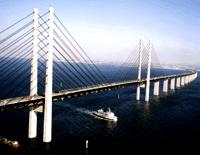
2 Beispiele: Grosser Belt und Oeresund


3 Millau Bridge (France)


4 Tejo Brücke
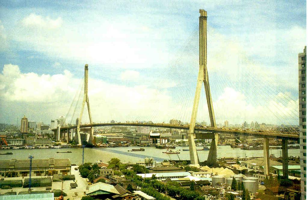
5 Shanghai
6 Monitoring of the Fatih Sultan Mehmet Bridge Concepts Group of Geodetic Metrology and Engineering Geodesy Institute of Geodesy and Photogrammetry ETH Zuerich
, spans the Bosporus strait (Turkish: Boğaziçi) near Istanbul. The bridge is situated between Hisarüstü (European side) and Kavacık (Asian side).")
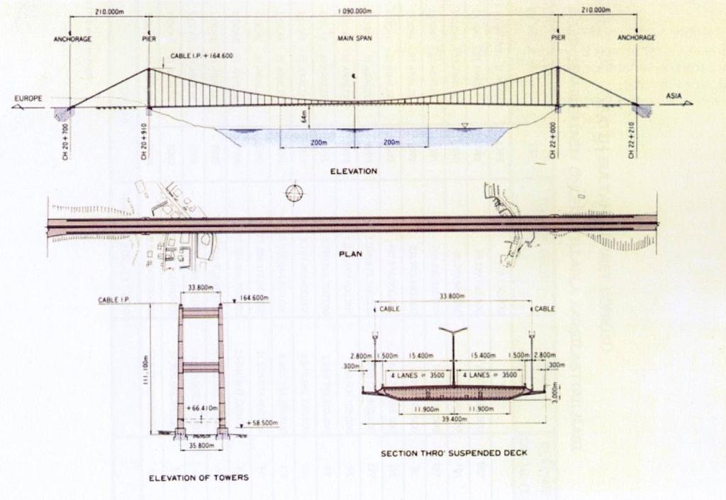
7 Fatih Sultan Mehmet Bridge (Bosphorus II) The Fatih Sultan Bridge, also known as the Second Bosporus Bridge (in Turkish: Fatih Sultan Mehmet Köprüsü or 2. Boğaziçi Köprüsü), spans the Bosporus strait (Turkish: Boğaziçi) near Istanbul. The bridge is situated between Hisarüstü (European side) and Kavacık (Asian side). It is a gravity-anchored suspension bridge with steel pylons and inclined hangers. The aerodynamic deck is hanging on double vertical steel cables. It is 1,510 m long with a deck width of 39 m. The distance between the towers (main span) is 1,090 m (World rank 2004: 13th) and their height over road level is 105 m. The clearance of the bridge from the sea level is 64 m.
8 Design
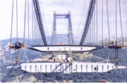
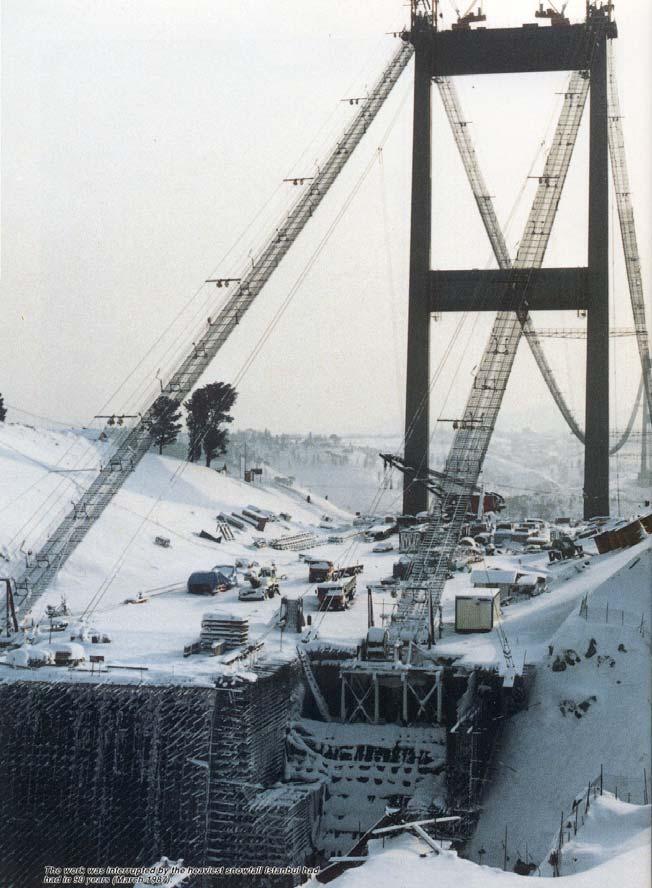
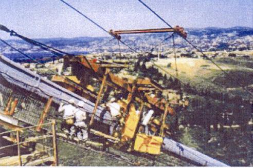
9 Impressions during Construction
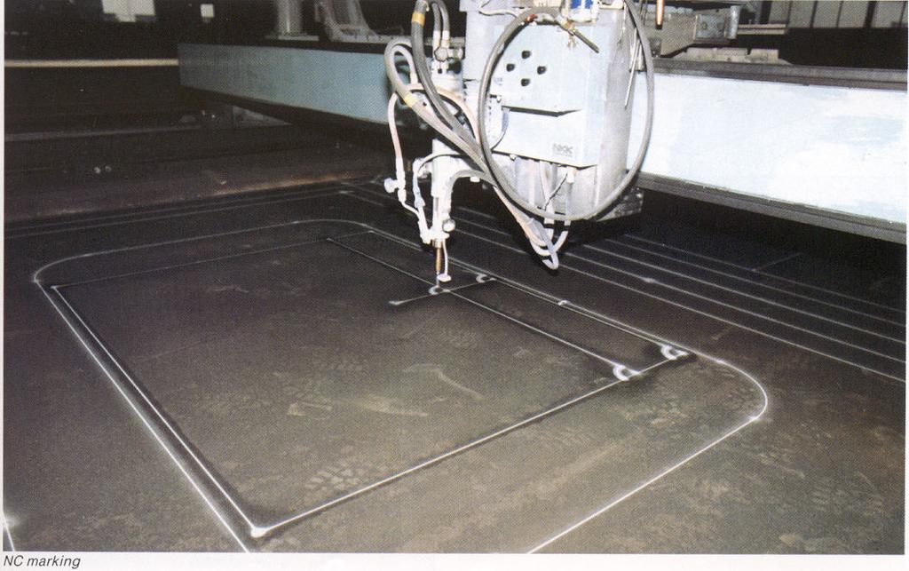

10 Manufacturing the Steel Parts

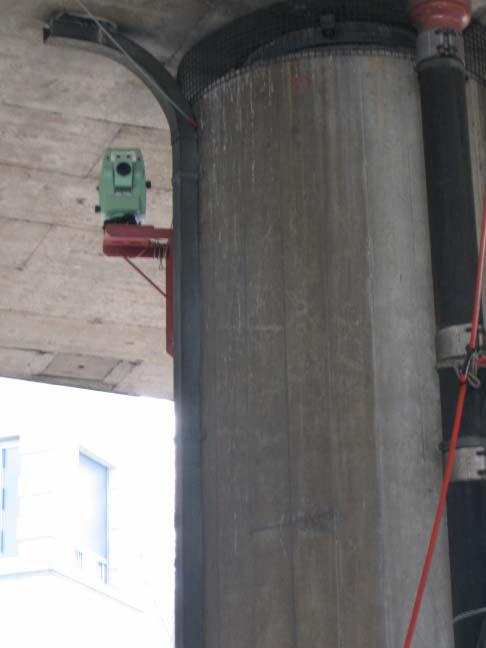
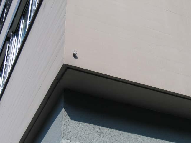
11 Staking out and Monitoring of Pillars
12 Bridge Dimensions 105m 105m 39m 1090m
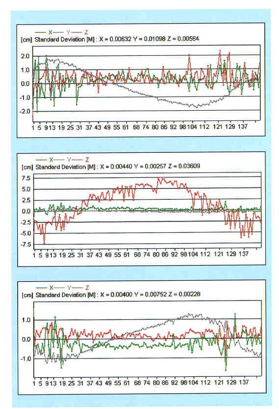
13 GPS related Informations: Torsions, Oszillations, Expansion,..
14 GPS Sensor Deployment AP S 2 Asian Pylons 2 Asian Quarter-span deck 2 Mid-span deck 2 Mid-span cables 2 European Quarter-span deck 2 European Pylons 1 Monitoring office (reference station) 1 Other location (reference station) 14 Total GPS AP N EPS EP N RS 2 AQ S AQ N M DS M CS M DN M CN EQ S EQ N RS 1

15 GPS Data Processing Leica GPS Spider Reference Station 1. Monitoring point Monitoring point Double check of the positioning results The baseline between the reference stations can also be monitored to check their long term stability. Reference station 2.
 LAN Serial to fiber converter Direct power supply (220v) Serial to fiber converter Direct power supply (220v) Analysis Software (from ITU/ETHZ) Leica GPS Spider Real time, permanent")
16 GPS Hardware Setup AT504 + Radome Dorne Margolin Choke Ring Antenna Leica GMX902 dual frequency GPS receiver Reference Station Monitoring Point Monitoring Point Serial to IP converter Direct power supply (220v) LAN Serial to fiber converter Direct power supply (220v) Serial to fiber converter Direct power supply (220v) Analysis Software (from ITU/ETHZ) Leica GPS Spider Real time, permanent connection LAN NMEA X,Y,Z Junction Box Fiber-optic -Analysis -Further computation -Alarming -GPS computation -NMEA data archiving -Sensor configuration -Virtual COM port interface to sensors
17 Proposed Communications 4-core armored single mode fiber cable 4-core armored multi mode fiber cable 4-core armored multi mode fiber cable Category 5 Ethernet cable APS APN EPN EPS MCN MCS AQS AQN MDS MDN EQN EQS CA1 CA2 Junction Box CA3 CA4 CA5 CA6 Junction Box RS1 CA7 RS2 Justification Very high reliability Built in redundancy (4-core fiber) High bandwidth (100Mbps or 1Gbps) Non-conductive (protection against lightning) Based on modern technology Expandable Monitoring Administration Building

18 Satellite Summary
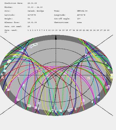
19 Sky Plot

20 Satellite Elevation
21 Output of GPS based Health Monitoring Monitoring of the load response (traffic, wind, earthquakes, Karmaneffects ) Determination of linear and torsional (twist) oscillations (10Hz) Monitoring of seasonal movements (long term thermal effects) Monitoring of permanent deformations (settlements, shifts, tilt..) Daily temperature behaviour (Expansion, )

22 Time Series and Spectra of the Bosporus Bridge O. Akyılmaz, R. N. Çelik, N. Apaydın, T. Ayan

23 Dominant Frequencies O. Akyılmaz, R. N. Çelik, N. Apaydın, T. Ayan

24 Combination of GPS and Photogrammetric Measurements Total Station GPS Brunner 2002 Brunner 2006 Hide et.al 2005 Referencing of GPS & Photogrammetric Sensors Laserdiode FOV
25 Preliminary Sensor and Evaluation Concept GPS CCD Meteo Sensors Accelerometers Relative Positions Temp. Wind High Frequency Accelerations drifts, cyclic-effects, low frequency oscillations, Kalman Filtering Fourier Analysis (Frequency, Amplitude, Phase-shift) 2 Step-Integration Velocity Trajectory Extensometers Sensors Displacements Measurands Strain, Stress,. Computation

26 Earthquake Signals
27 Staking out and Monitoring of small bridges Monitoring using Total Stations Hardbrücke Zürich
28 Networks of Bridges Handbuch Ingenieurvermessung
29 Basic Monitoring Concept Möser,Bauwerksmonitoring

30 Bridge Monitoring Overview
31 Bridge Monitoring Overview G1.1 G1.2 G2.1 G X [m] HP Y [m]

32 Bridge Monitoring Targets
33 Bridge Monitoring TT and Reference Point
34 Bridge Monitoring Time Series Target G1.2 Displacement [m] along across vertical : : :00 Time :00 Target 60.2 Displacement [m] along across vertical : : :00 Time :00
35 Bridge Monitoring Frequency Analysis (Longitudinal Component) Relative Deformation [mm] Time [days] 10.0 Amplitude [mm] Period [days]
36 Bridge Monitoring Frequency Analysis (Vertical Component) Relative Deformation [mm] Time [days] 0.4 Amplitude [mm] Period [days] longterm (temperature) daily (traffic, temperature?) weekly (traffic?)
37 Bridge Monitoring Crosscorrelation (Temperature Deformation) Relative Deformation [mm] Time [days] Temperature [ C] 1.0 Correlation [] Lag [Hours]
38 END

39 Analysis of a building s behaviour by test signals
STRUCTURAL BRIDGE HEALTH MONITORING WITH GLONASS AND GPS THE YEONG-JONG BRIDGE IN SOUTH KOREA
 Joël VAN CRANENBROECK Leica Geosystems AG, Switzerland, joel.vancranenbroeck@leica-geosystems.com STRUCTURAL BRIDGE HEALTH MONITORING WITH GLONASS AND GPS THE YEONG-JONG BRIDGE IN SOUTH KOREA Key words:
Monitoring Lecture ETH Zürich, Michael Rutschmann
 Monitoring Lecture 5.11.2008 ETH Zürich, Michael Rutschmann Monitoring lecture Contents 1. Monitoring System Intro 2. Different Setup of Monitoring Systems 3. GeoMoS (Monitor and Analyzer) 4. Setup of
Mass Structure Deformation Monitoring using Low Cost Differential Global Positioning System Device
 American Journal of Applied Sciences 6 (1): 152-156, 2009 ISSN 1546-9239 2009 Science Publications Mass Structure Deformation Monitoring using Low Cost Differential Global Positioning System Device Ramin
Assessment of high-rate GPS using a single-axis shake table
 Assessment of high-rate GPS using a single-axis shake table S. Häberling, M. Rothacher, A. Geiger Institute of Geodesy and Photogrammetry, ETH Zurich Introduction Project: Study the applicability of high-rate
Leica Spider Infrastructure HW Solutions Introducing: Leica GR30 & GR50
 Leica Spider Infrastructure HW Solutions Introducing: Leica GR30 & GR50 Reliable solutions for today and tomorrow Leica Spider Integrated Solutions Introducing: Leica GR30 & GR50 Outline Introducing Leica
Combining Terrestrial and GNSS Technolgies for Geodetic Monitoring. Neil ASHCROFT Leica Geosystems Engineering Segment Manager
 Combining Terrestrial and GNSS Technolgies for Geodetic Monitoring Neil ASHCROFT Leica Geosystems Engineering Segment Manager Structural Monitoring Technolgies Introduction Monitoring Instrumentation Reflectors,
Structural Health Monitoring of bridges using accelerometers a case study at Apollo Bridge in Bratislava
 UDC: 531.768 539.38 543.382.42 DOI: 10.14438/gn.2015.03 Typology: 1.01 Original Scientific Article Article info: Received 2015-03-08, Accepted 2015-03-19, Published 2015-04-10 Structural Health Monitoring
Proposed standard for permanent GNSS reference stations in the Nordic countries
 Version 0.6 2003-05-15 Proposed standard for permanent GNSS reference stations in the Nordic countries Introduction Subproject A0 of the project Nordic Real-time Positioning Service Gunnar Hedling, Finn
REAL-TIME MONITORING OF HIGHWAY BRIDGES USING "DREAMS"
 Proceedings, 11 th FIG Symposium on Deformation Measurements, Santorini, Greece, 2003. REAL-TIME MONITORING OF HIGHWAY BRIDGES USING "DREAMS" Günter W. Hein and Bernhard Riedl Institute of Geodesy and
EXPERIMENTAL MODAL AND AERODYNAMIC ANALYSIS OF A LARGE SPAN CABLE-STAYED BRIDGE
 The Seventh Asia-Pacific Conference on Wind Engineering, November 82, 29, Taipei, Taiwan EXPERIMENTAL MODAL AND AERODYNAMIC ANALYSIS OF A LARGE SPAN CABLE-STAYED BRIDGE Chern-Hwa Chen, Jwo-Hua Chen 2,
LONG-TERM MONITORING OF SEOHAE CABLE-STAYED BRIDGE USING GNSS AND SHMS
 Istanbul Bridge Conference August 11-13, 2014 Istanbul, Turkey LONG-TERM MONITORING OF SEOHAE CABLE-STAYED BRIDGE USING GNSS AND SHMS J. C. Park 1 and J. I. Shin 2 and H. J. Kim 3 ABSTRACT The Seohae cable-stayed
CONCEPT OF INTEGRATED CONTROL SYSTEM FOR MONITORING GEOMETRIC CHANGES OF THE TEMPORARY BRIDGE CROSSINGS
 CONCEPT OF INTEGRATED CONTROL SYSTEM FOR MONITORING GEOMETRIC CHANGES OF THE TEMPORARY BRIDGE CROSSINGS A. Bartnicki 1), J. Bogusz 2), G. Nykiel 2), M. Szołucha 2), M. Wrona 2) 1) Faculty of Mechanical
Investigating the Movements of Bosporus Bridge by Different Types of Loads
 Investigating the Movements of Bosporus Bridge by Different Types of Loads Hediye ERDOĞAN, Burak AKPINAR, V.Engin GÜLAL, Ercenk. ATA, Turkey Key words: Bridge Surveying, Bosporus Bridge, RTK GPS, Fast
Guide to GNSS Base stations
 Guide to GNSS Base stations Outline Introduction Example of a base station (TUMSAT) Preparation for setting up a base station Procedure for setting up a base station Examples at two other universities
Structure Health Monitoring System Using MEMS-Applied Vibration Sensor
 Structure Health Monitoring System Using MEMS-Applied Vibration Sensor SAKAUE Satoru MURAKAMI Keizo KITAGAWA Shinji ABSTRACT Recently, studies have come to be increasingly energetically conducted on structure
Deformation monitoring of Danube bridges in Bratislava by integrated measurement system
 Presented at the FIG Working Week 2017, May 29 - June 2, 2017 in Helsinki, Finland Deformation monitoring of Danube bridges in Bratislava by integrated measurement system Alojz KOPÁČIK Bridges over the
Case Study : Yokohama-Bay Bridge
 Case Study : Yokohama-Bay Bridge D3-X,D3-Y,D3-Z D6-YL,D6-ZL D8-YL,D8-ZL D1-X,D1-Y,D1-Z D7-X,D7-Y,D7-Z D9-X,D9-Y,D9-Z D5-X,D5-Y,D5-Z D2-Y,D2-Z D4-Y,D4-Z D6-YR,D6-ZR D8-YR,D8-ZR 200 m 460 m 200 m T4-X, T4-Y
Establishing a Geodetic Monitoring System for Gotvand Dam
 1 Establishing a Geodetic Monitoring System for Gotvand Dam Reza Esmaeili, Iran Joel Vancranenbroeck, Belgium Key words: geodetic monitoring system, dam monitoring SUMMARY Geodetic monitoring is one of
Leica GRX1200 Series High Performance GNSS Reference Receivers
 Leica GRX1200 Series High Performance GNSS Reference Receivers Leica GRX1200 Series For permanent reference stations The Leica GRX1200 Series, part of Leica s new System 1200, is designed specifically
Innovation and Experience in GNSS Bridge Real Time 3D- Monitoring System
 Innovation and Experience in GNSS Bridge Real Time 3D- Monitoring System Joël van Cranenbroeck, Managing Director CGEOS Creative GeoSensing sprl-s Rue du Tienne de Mont, 11 5530 MONT, Belgium Transportation
Determination of refractivity variations with GNSS and ultra-stable frequency standards
 Determination of refractivity variations with GNSS and ultra-stable frequency standards Markus Vennebusch, Steffen Schön, Ulrich Weinbach Institut für Erdmessung (IfE) / Institute of Geodesy Leibniz-Universität
MODIFIED GPS-OTF ALGORITHMS FOR BRIDGE MONITORING: APPLICATION TO THE PIERRE-LAPORTE SUSPENSION BRIDGE IN QUEBEC CITY
 MODIFIED GPS-OTF ALGORITHMS FOR BRIDGE MOITORIG: APPLICATIO TO THE PIERRE-LAPORTE SUSPESIO BRIDGE I QUEBEC CIT Rock Santerre and Luc Lamoureux Centre de Recherche en Géomatique Université Laval Québec,
Equipment List For GNSS Networks and Reference Stations
 Equipment List For GNSS Networks and Reference Stations GNSS Reference Station with GPS Spider Software Essential Items: For Data logging only: For transmitting RTK/DGPS data: a - Power supply l - Cable
Leica GRX1200+ Series High Performance GNSS Reference Receivers
 Leica GRX1200+ Series High Performance GNSS Reference Receivers Leica GRX1200+ Series For permanent reference stations The Leica GRX1200+ Series, part of Leica's future proof System 1200, is designed specifically
Guide to GNSS Base stations
 Guide to GNSS Base stations Outline Introduction Example of Base Station (TUMSAT) Preparation for setting up a base station Procedure for setting up a base station Example of each Univ. Based on documents
New Guide to GNSS Base stations
 New Guide to GNSS Base stations Asian Base Stations Project Updated on December 2017 Outline 1 st Chapter (page3 page25) -Setting of The Base Station- Introduction Example of base Station (TUMSAT) Preparation
Full-scale experiment using GPS sensors for dynamic tests
 Full-scale experiment using GPS sensors for dynamic tests Lucia Faravelli 1, Sara Casciati 2, Clemente Fuggini 1 1 Department of Structural Mechanics, University of Pavia, Italy E-mail: lucia@dipmec.unipv.it,
MEASURING THE DYNAMIC DEFORMATION OF BRIDGES USING A TOTAL STATION
 Proceedings, 11 th FIG Symposium on Deformation Measurements, Santorini, Greece, 23. MEASURING THE DYNAMIC DEFORMATION OF BRIDGES USING A TOTAL STATION Emily Cosser, Gethin W Roberts, Xiaolin Meng, Alan
- GOMS II. -GOMS II Gearbox Online Monitoring System. P o w e r T r a n s m i s s i o n. Application Note Wind Energy
 -GOMS II Gearbox Online Monitoring System Application Note Wind Energy Content: 1 SYSTEM DESCRIPTION EGOMS II WIND... 3 1.1 System for Online Vibration Measurement...4 1.2 Technical Details of the EGOMS
The GNSS Active Control Point Concept Get the {dynamic} Reference Points when You Need
 The GNSS Active Control Point Concept Get the {dynamic} Reference Points when You Need Joel van Cranenbroeck Chair of Commission 6 WG 6.2 International Federation of Surveyors (FIG) Belgium, Europa 2 3
SPEEDBOX Technical Datasheet
 SPEEDBOX Technical Datasheet Race Technology Limited, 2008 Version 1.1 1. Introduction... 3 1.1. Product Overview... 3 1.2. Applications... 3 1.3. Standard Features... 3 2. Port / Connector details...
The Reasons to Succeed or to Fail a GNSS Network RTK Project
 The Reasons to Succeed or to Fail a GNSS Network RTK Project Joël van Cranenbroeck, Managing Director CGEOS Creative Geosensing sprl-s, Belgium Andy Yin, International Sales Director ComNav Technology
Implementation and analysis of vibration measurements obtained from monitoring the Magdeburg water bridge
 Implementation and analysis of vibration measurements obtained from monitoring the Magdeburg water bridge B. Resnik 1 and Y. Ribakov 2 1 BeuthHS Berlin, University of Applied Sciences, Berlin, Germany
USING SATELLITES TO MONITOR SEVERN BRIDGE STRUCTURE, UK
 USING SATELLITES TO MONITOR SEVERN BRIDGE STRUCTURE, UK G. W. Roberts a*, C. J. Brown b, X. Tang a, O. Ogundipe c a Faculty of Science and Engineering, The University of Nottingham Ningbo China b School
3-DEMON MONITORING PLATFORM: EXAMPLES OF APPLICATIONS IN STRUCTURAL AND GEOTECHNICAL MONITORING PROJECTS
 3-DEMON MONITORING PLATFORM: EXAMPLES OF APPLICATIONS IN STRUCTURAL AND GEOTECHNICAL MONITORING PROJECTS Luca MANETTI, Daniele INAUDI and Branko GLISIC Smartec SA, Switzerland Abstract: The 3DeMoN (3-Dimentional
TESTING PROCEDURES FOR THE MONITORING OF SEISMIC INDUCED VIBRATIONS ON A CABLE-STAYED HIGHWAY BRIDGE
 Proceedings, 11 th FIG Symposium on Deformation Measurements, Santorini, Greece, 23. TESTING PROCEDURES FOR THE MONITORING OF SEISMIC INDUCED VIBRATIONS ON A CABLE-STAYED HIGHWAY BRIDGE Maria Tsakiri 1,
[ tima-datasheet-en v11.1 ]
![[ tima-datasheet-en v11.1 ]](/thumbs/92/109134204.jpg "[ tima-datasheet-en v11.1 ]") specifically designed for protection, automation and control applications in power systems 60 ns (99%) maximum time deviation single or dual 10/100Base-T Ethernet port(s) VLAN / IEEE 802.1Q support RS232
specifically designed for protection, automation and control applications in power systems 60 ns (99%) maximum time deviation single or dual 10/100Base-T Ethernet port(s) VLAN / IEEE 802.1Q support RS232
The VIRGO Environmental Monitoring System
 The VIRGO Environmental Monitoring System R. De Rosa University of Napoli - Federico II and INFN - Napoli Signaux, Bruits, Problèmes Inverses INRA - Nice, 05-05-2008 - Slow Monitoring System - Environmental
DYNAMIC CHARACTERISTICS OF A BRIDGE ESTIMATED WITH NEW BOLT-TYPE SENSOR, AMBIENT VIBRATION MEASUREMENTS AND FINITE ELEMENT ANALYSIS
 C. Cuadra, et al., Int. J. of Safety and Security Eng., Vol. 6, No. 1 (2016) 40 52 DYNAMIC CHARACTERISTICS OF A BRIDGE ESTIMATED WITH NEW BOLT-TYPE SENSOR, AMBIENT VIBRATION MEASUREMENTS AND FINITE ELEMENT
USING AUTHOR S GNSS RTK MEASURMENT SYSTEM FOR INVESTIGATION OF DISPLACEMENT PARAMETERS OF STRUCTURE
 USING AUTHOR S GNSS RTK MEASURMENT SYSTEM FOR INVESTIGATION OF DISPLACEMENT PARAMETERS OF STRUCTURE M. Figurski, M. Wrona, G. Nykiel Center of Applied Geomatics Military University of Technology 2 Kaliskiego
AIMS Radar Specifications
 Transmitted Frequency: Peak Radiated Power: Average Power: Antenna Beamwidth: 9.23 GHz 1 Watt (Optional 2 to 80 Watts) 6.25 microwatts up to 0.4 watts; < 1 milliwatt for most applications Fast-Scan (rotating):
Geodetic monitoring experiment by low-cost GNSS receivers and gogps positioning engine
 Geodetic monitoring experiment by low-cost GNSS receivers and gogps positioning engine Stefano Caldera1, Eugenio Realini1, Daisuke Yoshida2 1 2 Geomatics Research & Development (GReD) srl, c/o ComoNExT,
Alexandru Lepadatu* and Christian Tiberius GPS for structural health monitoring case study on the Basarab overpass cable-stayed bridge
 DOI 10.1515/jag-2013-0020 Journal of Applied Geodesy 2014; 8 (1):65 85 Research article Alexandru Lepadatu* and Christian Tiberius GPS for structural health monitoring case study on the Basarab overpass
Effects of Temperature Variation on Cable Forces of an Extradosed Bridge
 6th European Workshop on Structural Health Monitoring - We.4.B.4 More info about this article: http://www.ndt.net/?id=445 Effects of Temperature Variation on Cable Forces of an Extradosed Bridge C.-C.
Design and Navigation Control of an Advanced Level CANSAT. Mansur ÇELEBİ Aeronautics and Space Technologies Institute Turkish Air Force Academy
 Design and Navigation Control of an Advanced Level CANSAT Mansur ÇELEBİ Aeronautics and Space Technologies Institute Turkish Air Force Academy 1 Introduction Content Advanced Level CanSat Design Airframe
GEONET -CORS Network of japan-
 GEONET -CORS Network of japan- Basara Miyahara Geospatial Information Authority of Japan Geospatial and GNSS CORS Infrastructure Forum Kuala Lumpur - Malaysia Geospatial Information Authority of Japan
Patented Precision. 8 August US Patent 6,775,914 Can Patent 2,405,133 Other Patents Pending. surpro.com
 Patented Precision 8 August 2014 US Patent 6,775,914 Can Patent 2,405,133 Other Patents Pending surpro.com 1 The New SurPRO 4000 SurPRO comes from words Surface & Profiler Used on roads, structures, runways
Black Marlin radar systems may be purchased with a flat-top radome for mounting cameras on
 SPECIFICATIONS The Black Marlin is DMT s midrange security radar system. It may be used to search and track threats from land and sea. This radar is an X- Band, pulsed- Doppler system that operates in
Risk control online deformation monitoring inside an urban TBMdriven tunnel using the tshape measurement system
 World Tunnel Congress 2013 Geneva Underground the way to the future! G. Anagnostou & H. Ehrbar (eds) 2013 Taylor & Francis Group, London ISBN 978-1-138-00094-0 Risk control online deformation monitoring
Speed Sensor Range (VBSS05 VBSS100_V4G) Features
 Features") Based on a range of high accuracy GPS engines, VBOX Speed Sensors offer the ultimate non-contact measurement solution. With 5 Hz, 10 Hz, 20 Hz and 100 Hz GPS update rate options available, the speed sensor
Based on a range of high accuracy GPS engines, VBOX Speed Sensors offer the ultimate non-contact measurement solution. With 5 Hz, 10 Hz, 20 Hz and 100 Hz GPS update rate options available, the speed sensor
A REMOTE BRIDGE HEALTH MONITORING SYSTEM USING COMPUTATIONAL SIMULATION AND GPS SENSOR DATA.
 Proceedings, th FIG Symposium on Deformation Measurements, Santorini, Greece, 003. A REMOTE BRIDGE HEALTH MONITORING SYSTEM USING COMPUTATIONAL SIMULATION AND GPS SENSOR DATA. Gethin Roberts, Xiaolin Meng,
Bulletin of the Seismological Society of America, Vol. 73, No. 1. pp , February 1983
 Bulletin of the Seismological Society of America, Vol. 73, No. 1. pp. 297-305, February 1983 AN EARTHQUAKE ALARM SYSTEM FOR THE MAUI A OFFSHORE PLATFORM, NEW ZEALAND BY R. G. TYLER AND J. L. BECK ABSTRACT
Monitoring of Bridge Deformation Using GPS Technique
 KSCE Journal of Civil Engineering (2009) 13(6):423-431 DOI 10.1007/s12205-009-0423-y Structural Engineering www.springer.com/12205 Monitoring of Bridge Deformation Using GPS Technique Mosbeh R. Kaloop*
Local Control Network of the Fiducial GLONASS/GPS Station
 Related Contributions 333 Local Control Network of the Fiducial GLONASS/GPS Station V.I. KAFTAN, R.A. TATEVIAN 1 Abstract The controlling geodetic network for the Moscow station of the Fiducial Astro-Geodetic
SPAN Technology System Characteristics and Performance
 SPAN Technology System Characteristics and Performance NovAtel Inc. ABSTRACT The addition of inertial technology to a GPS system provides multiple benefits, including the availability of attitude output
CHC MINING DEFORMATION MONITORING SOLUTION
 CHC MINING DEFORMATION MONITORING SOLUTION Safety is first in mining. CHC offers solutions designed to improve safety for personnel on the ground and in the cab with 24/7 precision positioning for automatic
SOFTWARE DEVELOPMENT FOR GEODETIC TOTAL STATIONS IN MATLAB
 SOFTWARE DEVELOPMENT FOR GEODETIC TOTAL STATIONS IN MATLAB Imrich Lipták Slovak University of Technology in Bratislava, Faculty of Civil Engineering, Department of Surveying Radlinského 11, 813 68 Bratislava
MODAL IDENTIFICATION OF BILL EMERSON BRIDGE
 The 4 th World Conference on Earthquake Engineering October -7, 8, Beijing, China MODAL IDENTIFICATION OF BILL EMERSON BRIDGE Y.. hang, J.M. Caicedo, S.H. SIM 3, C.M. Chang 3, B.F. Spencer 4, Jr and. Guo
Deformation Monitoring Solutions First Monitoring Project in Slovenia
 Deformation Monitoring Solutions First Monitoring Project in Slovenia Leica Tour 2009 Slovenia The Team University of Ljubljana, Faculty of Natural Sciences and Engineering, Chair for Mine Surveying and
REAL-TIME BRIDGE DEFLECTION AND VIBRATION MONITORING USING AN INTEGRATED GPS/ACCELEROMETER/PSEUDOLITE SYSTEM
 Proceedings, 11 th FIG Symposium on Deformation Measurements, Santorini, Greece, 23. REAL-TIME BRIDGE DEFLECTION AND VIBRATION MONITORING USING AN INTEGRATED GPS/ACCELEROMETER/PSEUDOLITE SYSTEM Xiaolin
Single Frequency GPS for Bridge Deflection Monitoring: Progress and Results
 Single Frequency GPS for Bridge Deflection Monitoring: Progress and Results Emily COSSER, Gethin W ROBERTS, Xiaolin MENG and Alan H DODSON, United Kingdom Key words: GPS, single frequency, ambiguity resolution,
P E R F O R M A N C E D E P E N D A B I L I T Y A V A I L A B I L I T Y
 PeakVelocity in Octave Bandwidth (db wrt 1m 2 /s 2 ) 0-25 -50-75 -100-125 -150-175 -200-225 -250 The Earthquake Spectrum Local events ~10 km Several seconds to 30 Hz Regional ~100 km 30 seconds to 10 Hz
Field Testing of Wireless Interactive Sensor Nodes
 Field Testing of Wireless Interactive Sensor Nodes Judith Mitrani, Jan Goethals, Steven Glaser University of California, Berkeley Introduction/Purpose This report describes the University of California
Federal Office of Topography swisstopo LPT (swisstopo) EPN analysis center and the switch to Bernese GNSS Software V5.2
 EPN analysis center and the switch to Bernese GNSS Software V5.2") LPT (swisstopo) EPN analysis center and the switch to Bernese GNSS Software V5.2 D. Ineichen, E. Brockmann, S. Schaer LPT s contribution for the EPN 52 stations (from France to Estonia) Development of
LPT (swisstopo) EPN analysis center and the switch to Bernese GNSS Software V5.2 D. Ineichen, E. Brockmann, S. Schaer LPT s contribution for the EPN 52 stations (from France to Estonia) Development of
GPS-Aided INS Datasheet Rev. 3.0
 1 GPS-Aided INS The Inertial Labs Single and Dual Antenna GPS-Aided Inertial Navigation System INS is new generation of fully-integrated, combined GPS, GLONASS, GALILEO, QZSS, BEIDOU and L-Band navigation
DavidsonSensors. Fiber Optic Sensing System Definitions. Davidson Fiber Optic Sensing System
 DavidsonSensors October 2007 Fiber Optic Sensing System Davidson Fiber Optic Sensing System DavidsonSensors Measure Temperature, Pressure, Vacuum, Flow, Level, and Vibration DavidsonSensors Transmit Intrinsically
Investigation regarding Different Antennas combined with Low-cost GPS Receivers
 Investigation regarding Different Antennas combined with Low-cost GPS Receivers FIG Working Week 2013 TS 05C - GNSS Positioning and Measurement I Commission 5 Li Zhang, Volker Schwieger Institute of Engineering
Wideband Quasi-Omni Antenna
 DATA SHEET Two foot (0.5 m), two port, quasi-omni antenna with uniform horizontal beamwidths covering the extended band from 1710-2690 MHz 360 of coverage area across all bands of operation in a single
xoem500 Hardware Integration Manual Inertial and GNSS measurement system Confidently. Accurately.
 xoem500 xf Inertial and GNSS measurement system Hardware Integration Manual Confidently. Accurately. Table of contents Introduction 5 Related documents 6 Precautions 7 Compliance testing 7 Hardware description
GNSS FOR STRUCTURAL DEFORMATION AND DEFLECTION MONITORING: IMPLEMENTATION AND DATA ANALYSIS
 GNSS FOR STRUCTURAL DEFORMATION AND DEFLECTION MONITORING: IMPLEMENTATION AND DATA ANALYSIS Xaiolin Meng, Gethin Wyn Roberts, Alan Henry Dodson, Sean Ince, Samantha Waugh Institute of Engineering Surveying
Operational deformations in long span bridges
 Operational deformations in long span bridges James Mark William Brownjohn Vibration Engineering Section, College of Engineering, Mathematics and Physical Sciences University of Exeter, North Park Road,
IBIS range. GeoRadar Division. GeoRadar Division. Static and Dynamic Monitoring of Civil Engineering Structures by Microwave Interferometry
 Static and Dynamic Monitoring of Civil Engineering Structures by Microwave Interferometry Garry Spencer and Mark Bell 1 PRODUCTS IBIS range APPLICATIONS IBIS - FL LANDSLIDE & DAM MONITORING IBIS - FM SLOPE
MATERIAL SPECIFICATIONS FOR WIRELESS LINK
 MATERIAL SPECIFICATIONS FOR WIRELESS LINK SECTION 1 GENERAL The Wireless Link specification is for the listed components to be used in the Wireless Link pay item. Each component includes the antennae and
GPS-Aided INS Datasheet Rev. 2.7
 1 The Inertial Labs Single and Dual Antenna GPS-Aided Inertial Navigation System INS is new generation of fully-integrated, combined GPS, GLONASS, GALILEO, QZSS and BEIDOU navigation and highperformance
TCG 02-G FULL FEATURED SATELLITE CLOCK KEY FEATURES SUPPORTS
 FULL FEATURED SATELLITE CLOCK TCG 02-G The TCG 02-G is a highly accurate, full featured GPS and GLONASS (GNSS) clock. Offering multiple oscillator options, Time Code and Frequency outputs, it fits virtually
Concept for Offshore Wind Turbine Foundation Monitoring
 Concept for Offshore Wind Turbine Foundation Monitoring World of Technology & Science Wim Hendricx Utrecht, October 4-7 th, 2016 Siemens PLM/STS/LMS Engineering Introduction Classical Condition Monitoring
SPB-TT and SPB-TS Linear Encoder For Pressbrake applications
 Specification Encoder Assembly SPB-TS and SPB-TT Accuracy +/- 10µm Resolution 1µm or 5µm Output Type RS422 Differential Quadrature Max. Traverse Speed 60m/min (198ft/min) Max. Acceleration 100m/s2 (10g)
DATASHEET. MEMS Tilt Beam. Proven MEMS technology Excellent thermal stability Single cable digital BUS system High accuracy & resolution
 DATASHEET MEMS Tilt Beam Proven MEMS technology Excellent thermal stability Single cable digital BUS system High accuracy & resolution Overview APPLICATIONS For monitoring tilt in: Retaining walls Diaphragm
IOMAC' May Guimarães - Portugal REAL-TIME STRUCTURAL HEALTH MONITORUN AND DAMAG DETECTION
 IOMAC'13 5 th International Operational Modal Analysis Conference 2013 May 13-15 Guimarães - Portugal REAL-TIME STRUCTURAL HEALTH MONITORUN AND DAMAG DETECTION Yavuz Kaya 1, Erdal Safak 2 ABSTRACT Structural
Structural Health Monitoring using a GPS sensor network
 Structural Health Monitoring using a GPS sensor network More info about this article: http://www.ndt.net/?id=23274 Nicolas Manzini 1,2, André Orcesi 1, Christian Thom 3, Antoine Clément 4, Serge Botton
al T TD ) ime D Faamily Products The RTD Family of products offers a full suite of highprecision GPS sensor positioning and navigation solutions for:
 ime D Faamily Products The RTD Family of products offers a full suite of highprecision GPS sensor positioning and navigation solutions for:") Reeal ynnamics al T amics (R TD ) ime D RTD) Time Dy Faamily mily ooff P roducts Products The RTD Family of products offers a full suite of highprecision GPS sensor positioning and navigation solutions
Reeal ynnamics al T amics (R TD ) ime D RTD) Time Dy Faamily mily ooff P roducts Products The RTD Family of products offers a full suite of highprecision GPS sensor positioning and navigation solutions
Seismicity and Strong Motion Stations in Euro-Mediterranean Region
 STRONG-MOTION DATA ACQUISITION, PROCESSING AND UTILIZATION IN TURKEY M.Erdik, Y.Fahjan and E.Durukal Bogazici University, Istanbul, Turkey Seismicity and Strong Motion Stations in Euro-Mediterranean Region
Geodetic Reference Frame Theory
 Technical Seminar Reference Frame in Practice, Geodetic Reference Frame Theory and the practical benefits of data sharing Geoffrey Blewitt University of Nevada, Reno, USA http://geodesy.unr.edu Sponsors:
Chapter 2 Real-Time Structural Health Monitoring and Damage Detection
 Chapter 2 Real-Time Structural Health Monitoring and Damage Detection Yavuz Kaya and Erdal Safak Abstract Structural health monitoring (SHM) contains continuous structural vibration monitoring, extraction
3D Commercial Metrological Systems
 QDaedalus Augmentation of Total Stations by CCD Sensor for Automated Contactless High-Precision Metrology Sébastien Guillaume 1, Beat Bürki 1, Sylvain Griffet 2, Hélène Mainaud-Durand 2 1. Institut für
Guorong Hu & Michael Moore Geodesy Section, Geoscience Australia
 Influence of using individual GPS receiver antenna calibrations on high precision geodetic positioning, case study: Northern Surat Basin Queensland 2015 GPS campaign Guorong Hu & Michael Moore Geodesy
TCG 02-G FULL FEATURED SATELLITE CLOCK KEY FEATURES SUPPORTS
 FULL FEATURED SATELLITE CLOCK TCG 02-G The TCG 02-G is a highly accurate, full featured GPS and GLONASS (GNSS) clock. Offering multiple oscillator options, Time Code and Frequency outputs, it fits virtually
Fumiaki UEHAN, Dr.. Eng. Senior Researcher, Structural Mechanics Laboratory, Railway Dynamics Div.
 PAPER Development of the Non-contact Vibration Measuring System for Diagnosis of Railway Structures Fumiaki UEHAN, Dr.. Eng. Senior Researcher, Structural Mechanics Laboratory, Railway Dynamics Div. This
Earthquake Resistance Test Specifications for Communications Equipment
 Earthquake Resistance Test Specifications for Communications Equipment (Edition: March 2018) NTT DOCOMO, INC. All rights reserved. TABLE OF CONTENTS 1. INTRODUCTION...1 2. EQUIPMENT TO BE TESTED...1 3.
rocket D I S H AirMax Carrier Class 2x2 PtP Bridge Dish Antenna Datasheet Models: RD-2G-24, RD-3G-26, RD-5G-30, RD-5G-34 Ultimate in RF Performance
 AirMax Carrier Class 2x2 PtP Bridge Dish Antenna Models: RD-2G-24, RD-3G-26, RD-5G-3, RD-5G-34 Ultimate in RF Performance Integrated Mount lets you easily snap Rocket M into place Incredible Range and
RECENT ACTIVITIES IN THE FIELD OF TIME AND FREQUENCY IN POLAND
 RECENT ACTIVITIES IN THE FIELD OF TIME AND FREQUENCY IN POLAND Jerzy Nawrocki Astrogeodynamical Observatory, Borowiec near Poznań, and Central Office of Measures, Warsaw, Poland Abstract The work of main
Picture 1 PC & USB Connection
 USB Ethernet HART Profi-bus DeviceNet EtherCAT CANopen CAN RS Zigbee Analog Switch Vibration-wire PWM SSI CDMA GPRS Wi-Fi USB Inclinometer Features - Reference with USB2.0 protocol - P2P and compatible
GPS-Aided INS Datasheet Rev. 2.6
 GPS-Aided INS 1 GPS-Aided INS The Inertial Labs Single and Dual Antenna GPS-Aided Inertial Navigation System INS is new generation of fully-integrated, combined GPS, GLONASS, GALILEO and BEIDOU navigation
Carrier Phase Multipath Corrections Based on GNSS Signal Quality Measurements to Improve CORS Observations
 Carrier Phase Multipath Corrections Based on GNSS Signal Quality Measurements to Improve CORS Observations Christian Rost and Lambert Wanninger Geodetic Institute Technische Universität Dresden Dresden,
WIND-INDUCED VIBRATION OF SLENDER STRUCTURES WITH TAPERED CIRCULAR CYLINDERS
 The Seventh Asia-Pacific Conference on Wind Engineering, November 8-2, 2009, Taipei, Taiwan WIND-INDUCED VIBRATION OF SLENDER STRUCTURES WITH TAPERED CIRCULAR CYLINDERS Delong Zuo Assistant Professor,
NAVIGAT Fiber-Optic Gyrocompass and Attitude Reference System. Sperry Marine. The Dynamic Solution for a Demanding Challenge
 NAVIGAT 2100 Fiber-Optic Gyrocompass and Attitude Reference System Sperry Marine The Dynamic Solution for a Demanding Challenge NAVIGAT 2100 Fiber-Optic Gyrocompass and Attitude Fiber-Optic Sensor Unit
EARTHQUAKE EARLY WARNING and RAPID LOSS INFORMATION GENERATION IN ISTANBUL. Mustafa Erdik Boğaziçi University, Istanbul
 EARTHQUAKE EARLY WARNING and RAPID LOSS INFORMATION GENERATION IN ISTANBUL Mustafa Erdik Boğaziçi University, Istanbul 1. Preparative Steps TIME Pre-seismic Co-seismic Post-seismic 2. Real-time Earthquake
Introduction to Measurement Systems
 MFE 3004 Mechatronics I Measurement Systems Dr Conrad Pace Page 4.1 Introduction to Measurement Systems Role of Measurement Systems Detection receive an external stimulus (ex. Displacement) Selection measurement
EE 304 TELECOMMUNICATIONs ESSENTIALS HOMEWORK QUESTIONS AND ANSWERS
 Homework Question 1 EE 304 TELECOMMUNICATIONs ESSENTIALS HOMEWORK QUESTIONS AND ANSWERS Allocated channel bandwidth for commercial TV is 6 MHz. a. Find the maximum number of analog voice channels that
4-Port Antenna Frequency Range Dual Polarization HPBW Adjust. Electr. DT
 4-Port Antenna Frequency Range Dual Polarization HPB Adjust. Electr. DT R1 790 960 0 10 2 8 set by hand or by optional RCU (Remote Control Unit) X 65 Y1 1710 2690 X 65 4-Port Antenna 790 960/1710 2690