Attitude Determination of Small Satellite: The GNSS Paradigm
|
|
|
- Angel Crawford
- 5 years ago
- Views:
Transcription


1 Attitude Determination of Small Satellite: The GNSS Paradigm Dr. Najam Abbas Naqvi Assistant Professor Department of Aeronautics and Astronautics Institute of Space Technology Islamabad, Pakistan
2 Personal Profile Academics PhD. Aerospace (GNC-GNSS), China Specialized MS-GNSS, Italy MS Electrical Engineering, NUST, PK BS Electrical Engineering, UET, PK Professional Experience Assistant Professor, IST, PK Satellite Control Engineer, SUPARCO Publications Attitude Determination and Control Global Navigation Satellite System
3 Scope Motivation and Objective Attitude Determination (AD) Global Navigation Satellite System Research Design and Methodology Results and Analysis Conclusion
4 Motivation and Objective To design and implement a short baseline, multiantenna, stand-alone, commercial-off-the-shelf (COTS), GPS based attitude determination system for a Spacecraft using the Code measurements of GPS signals.
5 Attitude Determination and Control System Spacecraft Computer Desired Attitude None (Passive) Linear Limit Cycle Non-Linear Control Law Real Time Attitude Estimation Control Commands Attitude Actuators Thrusters Magnetic Torque Rod Momentum and Reaction wheel Movable Components Deterministic Filters Real Time Attitude Determination Internal Disturbance Torques Spacecraft Dynamics External Disturbance Torques Definitive Attitude Determination Solar Arrays Flexible Components Rotating Mechanisms Fuel Slosh People Aerodynamics Magnetic Gravity Gradient Solar Radiation Filter Bias Determination Attitude Measurement Earth, Sun, Stars Magnetometer Gyroscopes Payload Sensors Attitude Sensors
6 ADS Flow diagram Mission Requirements Attitude Representation Selection Attitude Coordinate System Selection Attitude Sensors Selection Modeling of Orbit Propagator Satellite Kinematics Dynamics Modeling Modeling of Disturbance s & Sensors AD Algorithm Selection and Implementation
7 Attitude Sensors Sensor Pros Cons Sun Sensor Horizon Scanner Reliable, Simple, Cheap Expensive No measurement in eclipse Orbit dependent, Poor in yaw Magnetometer Cheap Continuous Coverage Low Altitude only Star Tracker Gyroscope Very Accurate High Band Width Expensive-Heavy- Complex Expensive-Drifts with time GPS Receiver Single Sensor Several Errors
8 Accuracy Comparison of Sensors Sensor Mass (Kg) Power (Watt) Accuracy (3σ) Measured Angles Cost (K$ U.S) Gyroscope Drift Rate: o to 1 o /hour Roll, Pitch, Yaw Sun Sensor o -3 o Roll Coarse, Precise Yaw Star Sensor o o Roll, Pitch, Yaw Horizon Sensor o -1 o Roll Coarse, Precise Pitch Magneto-meter <1 0.5 o -3 o Roll, Pitch, Yaw GPS (for Space) o -1 o Roll, Pitch, Yaw >100
9 Attitude Representation Comparison Method Euler Angles Direction Cosines Quaternions Pros If given φ, ψ, θ, then a unique orientation is required Orientation defines a unique DCM Computationally Robust Cons Singularity 6 constraints Non Intuitive Not Intuitive Need Transforms Application Best for Analytical and Design work Best for Design and analysis Ideal for digital control Implementation
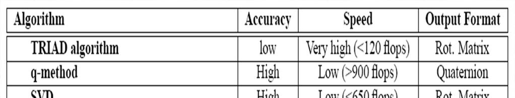
10 Attitude Determination Algorithms
11 AD : Recursive Estimation Algorithms REQUEST OPTIMAL REQUEST MME Euler-q Adaptive Optimal REQUEST Kalman Filter Unscented Filters Particle Filter The Orthogonal filter The Predictive filter Nonlinear observers Adaptive approaches
12 GNSS: Global Navigation Satellite System GNSS is a generic name for Global Navigation Satellite System, consisting of a Space Segment having a constellation of satellites in Medium Earth orbit at the height of 20,000 Km and above, Control Segment having Monitoring and Control stations to monitor / control/update the constellation of satellites and the User Segment; consisting of Receivers to give POSTION, VELOCITY and TIME of the static and mobile user all over the globe at all time using at least four satellites of the constellation in view.
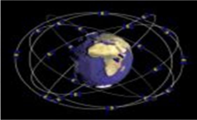
13 Architecture of GNSS Space Segment Ground Control Segment User Segment
14 The Evolution Of GNSS Four Major GNSS GPS (US Fully Operational Since 1994) GLONASS (USSR - Fully Operational Since 1995 suspended and partially operated after collapse- since 2011 Soviet GLONASS is fully operational) Galileo (Europe expected fully operational in 2020) Beidou (CHINA expected fully operational in 2020)
15 Regional Navigation Satellite System Satellite Based Augmentation System Quasi-Zenith Satellite System (QZSS) Indian Regional Navigation System IRNSS Wide Area Augmentation System (WAAS) European Geostationary Navigation Overlay Service (EGNOS) Multi-functional Satellite Augmentation System (MSAS) GPS Aided Geo Augmented Navigation (GAGAN) The GLONASS System for Differential Correction and Monitoring (SDCM), proposed by Russia. The Satellite Navigation Augmentation System (SNAS) proposed by China.
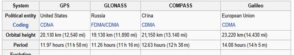
16 Comparison of Major GNSS
17 17 The GNSS (Triliteration) Principle ),, ( o o o z y x x y z ),, ( k k k z y x b r ρ k known measured unknown r k k k k b z z y y x x + + = ) ( ) ( ) ( ρ


18 GNSS in 2020 Source: cited from Asia Oceania is the 'Showcase of the New GNSS Era',presented at 5th QZSS user meeting (KOGURE, Satoshi Mr., 10th March 2010)
 Enabled revenue (Global) The projected long-term growth gives significant business opportunities for GNSS market.")
19 GNSS Market 7 bln GNSS devices by 2022 almost one for every person on the planet (billions) CAGR: 9% Global GNSS market size CAGR: 5% Core revenue (Global) Enabled revenue (Global) The projected long-term growth gives significant business opportunities for GNSS market. Along with the rapid development of new services and applications, the business environment of GNSS market is demanding and requires constant innovation on the supply side. Source: The European GNSS Programmes 19


20
21 Basic Principle of AD using GNSS
22 AD Using GNSS: Performance Factors Antenna Baseline Line Bias GPS Geometry Geometric Dilution of Precision; GDOP Attitude Dilution of Precision; ADOP Multipath Measurement Errors Signal To Noise Ratio; SNR Cycle Slip Antenna Positioning Receiver Noise Ambiguity Resolution
23 Error Sources in GNSS Observables
24 GADACS SPARTAN RADCAL REX II Gravity Probe B UNISAT Gyrostat UOSAT-12 ALSAT-1 GPS Based AD: Flying Experiments

25 GNSS based AD Georgi-ION-GNSS-2010 / Dec 2011 (PhD thesis)
26 X-Sat Antenna Platform Lin et.al. IEEE 2004


27
28 GNSS Range and Phase Model P ( t) = ρ ( t, t τ ) + I + T + dm + c[ dt ( t) dt ( T τ )] + s s s s s s s s r, f P, r, f r r, f r r, f r r c[ d ( t) + d ( t τ )] + ε s s s r, f f r P, r, f Φ ( t) = ρ ( t, t τ ) I + T + δ m + c[ dt ( t) dt ( t τ )] s s s s s s s s r, f Φ, r, f r r, f r r, f r r + c[ δ ( t) + δ ( t τ )] + λ [ φ ( t ) φ ( t )] + λ z + ε s s s s s s r, f f r f r, f 0 f 0 f r, f Φ, r, f ρ ( t, t τ ) = r ( t τ ) + dr ( t τ ) r ( t) dr ( t) s s s s s s P, r, f r r f r r r, f
29 Single Difference Code and Phase Observables
30 Double Difference Code and Phase Observables
31 Antenna Placements


32
33 Time Calculations GPS Master Observation File Time , Julian Day e+006 GPS Week 1399 Second of Week (SOW) e+005
34 Ephemeris Parameters of Visible Satellites SV-PRN af M Root a Delta n -9.57E E E E E-11 E omega Cuc -3.73E E E E E-09 Cus -3.73E E E E E-09 Crc Crs i I dot Cic 1.86E E E E E-09 Cis -1.86E E E E E-09 Omega0-9.03E Omega dot -8.44E E E E E-09 Toe af af Toc
35 SV-PRN af M Root a Delta n -9.57E E E E-11 E Omega Cuc -3.73E E E E-09 Cus -3.73E E E E-09 Crc Crs i I dot Cic 1.86E E E E-09 Cis -1.86E E E E-09 Omega Omega dot -8.44E E E E-09 Toe af af Toc

36 Visible Satellites in Inertial Frame Visible Satellite in ECEF Frame Sub-Satellite Points
37 Visible Satellites by Master Antenna (PRN) Pseudorange from Master Observation File (E+07 meters) Position of Visible Satellites in ECEF Frame (meters) E E E E E E E E E E E E E E E E E E E E E E E E E E E+07
38 Elevation of Visible Satellites (Degrees) Elevation of Visible Satellites`

39 Visibility Window during Mission Sky Plot of Visible Satellites

40 Number of Visible Satellites during Mission
41 Clock Errors (sec) Satellite Clock Offset Error Satellite Clock Relativistic Error E E E E E E E E E-09 Ionospheric Errors (meters) Tropospheric Errors (meters)
42 Corrected Pseudorange (meters) E E E E E E E E E07 Corrected Satellite Positions (meters) E E E E E E E E E E E E E E E E E E E E E E E E E E E+07 Dilution of Precisions GDOP TDOP PDOP HDOP VDOP
43 DOPs Variation
44 Mean Position of Master Antenna from 200 Epoch (meters) X Y Z Master Antenna Position Variations


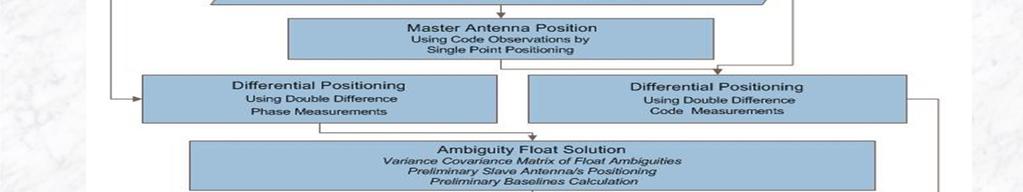
45 Flow diagram of differential Positioning using code observation
46 Mean Position of Slave-1 Antenna from 400 Epochs (meters) X Y Z Slave-1Antenna Position
47 Mean Baseline Components between Master and Slave-1 (meters) X Y Z Variations of Baseline Components
48 Mean Position of Slave-2 Antenna from 200 Epoch (meters) X Y Z Slave-2 Antenna Position
49 Baseline Components between Master and Slave-2 (meters) X Y Z Variation of Baseline Components
50 Attitude Determination Using Code Observations Direct Method (Degrees) Attitude Mean Std Yaw Pitch Roll
51 Attitude Determination Using Code Observations LS Method Orientation Mean/Degree Std/Degree Yaw Pitch Roll
52 Difference between Direct and Least Square Method (Degrees) Orientation Direct Method Least Square Method Difference Yaw Pitch Roll


53 Precise AD Using GNSS: Future AD Using GNSS AD Using GNSS AD Using GNSS AD Using GNSS LAMBDA Modified LAMBDA Constrained LAMBDA Multi Constrained LAMBDA EKF/UKF EKF/UKF EKF/UKF


54

55 GNSS at Institute of Space Technology Islamabad, Pakistan Maters of Science in Global Navigation Satellite System MS-GNSS


56 MS GNSS Curriculum According to the GNSS curriculum designed by the United Nations Office for Outer Space Affairs (UNOOSA)
57 Thank You Q & A Dr.Najam Naqvi najm_naqvi@yahoo.com
FieldGenius Technical Notes GPS Terminology
 FieldGenius Technical Notes GPS Terminology Almanac A set of Keplerian orbital parameters which allow the satellite positions to be predicted into the future. Ambiguity An integer value of the number of
Global Navigation Satellite Systems (GNSS)Part I EE 570: Location and Navigation
Part I EE 570: Location and Navigation") Lecture Global Navigation Satellite Systems (GNSS)Part I EE 570: Location and Navigation Lecture Notes Update on April 25, 2016 Aly El-Osery and Kevin Wedeward, Electrical Engineering Dept., New Mexico
Lecture Global Navigation Satellite Systems (GNSS)Part I EE 570: Location and Navigation Lecture Notes Update on April 25, 2016 Aly El-Osery and Kevin Wedeward, Electrical Engineering Dept., New Mexico
Global Navigation Satellite Systems II
 Global Navigation Satellite Systems II AERO4701 Space Engineering 3 Week 4 Last Week Examined the problem of satellite coverage and constellation design Looked at the GPS satellite constellation Overview
Minnesat: GPS Attitude Determination Experiments Onboard a Nanosatellite
 SSC06-VII-7 : GPS Attitude Determination Experiments Onboard a Nanosatellite Vibhor L., Demoz Gebre-Egziabher, William L. Garrard, Jason J. Mintz, Jason V. Andersen, Ella S. Field, Vincent Jusuf, Abdul
Challenges and Solutions for GPS Receiver Test
 Challenges and Solutions for GPS Receiver Test Presenter: Mirin Lew January 28, 2010 Agenda GPS technology concepts GPS and GNSS overview Assisted GPS (A-GPS) Basic tests required for GPS receiver verification
GPS and Recent Alternatives for Localisation. Dr. Thierry Peynot Australian Centre for Field Robotics The University of Sydney
 GPS and Recent Alternatives for Localisation Dr. Thierry Peynot Australian Centre for Field Robotics The University of Sydney Global Positioning System (GPS) All-weather and continuous signal system designed
GLOBAL POSITIONING SYSTEMS. Knowing where and when
 GLOBAL POSITIONING SYSTEMS Knowing where and when Overview Continuous position fixes Worldwide coverage Latitude/Longitude/Height Centimeter accuracy Accurate time Feasibility studies begun in 1960 s.
Effect of Quasi Zenith Satellite (QZS) on GPS Positioning
 on GPS Positioning") Effect of Quasi Zenith Satellite (QZS) on GPS ing Tomoji Takasu 1, Takuji Ebinuma 2, and Akio Yasuda 3 Laboratory of Satellite Navigation, Tokyo University of Marine Science and Technology 1 (Tel: +81-5245-7365,
Effect of Quasi Zenith Satellite (QZS) on GPS ing Tomoji Takasu 1, Takuji Ebinuma 2, and Akio Yasuda 3 Laboratory of Satellite Navigation, Tokyo University of Marine Science and Technology 1 (Tel: +81-5245-7365,
Fundamentals of GPS Navigation
 Fundamentals of GPS Navigation Kiril Alexiev 1 /76 2 /76 At the traditional January media briefing in Paris (January 18, 2017), European Space Agency (ESA) General Director Jan Woerner explained the knowns
Resection. We can measure direction in the real world! Lecture 10: Position Determination. Resection Example: Isola, Slovenia. Professor Keith Clarke
 Geography 12: Maps and Spatial Reasoning Lecture 10: Position Determination We can measure direction in the real world! Professor Keith Clarke Resection Resection Example: Isola, Slovenia Back azimuth
EE 570: Location and Navigation
 EE 570: Location and Navigation Global Navigation Satellite Systems (GNSS) Part I Aly El-Osery Kevin Wedeward Electrical Engineering Department, New Mexico Tech Socorro, New Mexico, USA In Collaboration
Errors in GPS. Errors in GPS. Geodetic Co-ordinate system. R. Khosla Fall Semester
 Errors in GPS Errors in GPS GPS is currently the most accurate positioning system available globally. Although we are talking about extreme precision and measuring distances by speed of light, yet there
The Global Positioning System
 The Global Positioning System 5-1 US GPS Facts of Note DoD navigation system First launch on 22 Feb 1978, fully operational in 1994 ~$15 billion (?) invested to date 24 (+/-) Earth-orbiting satellites
GPS Milestones, cont. GPS Milestones. The Global Positioning Sytem, Part 1 10/10/2017. M. Helper, GEO 327G/386G, UT Austin 1. US GPS Facts of Note
 The Global Positioning System US GPS Facts of Note DoD navigation system First launch on 22 Feb 1978, fully operational in 1994 ~$15 billion (?) invested to date 24 (+/-) Earth-orbiting satellites (SVs)
One Source for Positioning Success
 novatel.com One Source for Positioning Success RTK, PPP, SBAS OR DGNSS. NOVATEL CORRECT OPTIMIZES ALL CORRECTION SOURCES, PUTTING MORE POWER, FLEXIBILITY AND CONTROL IN YOUR HANDS. NovAtel CORRECT is the
Signal Quality Monitoring. Authors: Yury Yaskin, General Director, Chief designer. Valeriy Tyubalin, Deputy Chief designer
 Signal Quality Monitoring Authors: Yury Yaskin, General Director, Chief designer. Valeriy Tyubalin, Deputy Chief designer ICG-7 Meeting, Beijing, China, 4-9 November 2012 Avnues of development: 1. Controlling
Guochang Xu GPS. Theory, Algorithms and Applications. Second Edition. With 59 Figures. Sprin ger
 Guochang Xu GPS Theory, Algorithms and Applications Second Edition With 59 Figures Sprin ger Contents 1 Introduction 1 1.1 AKeyNoteofGPS 2 1.2 A Brief Message About GLONASS 3 1.3 Basic Information of Galileo
Global Positioning System: what it is and how we use it for measuring the earth s movement. May 5, 2009
 Global Positioning System: what it is and how we use it for measuring the earth s movement. May 5, 2009 References Lectures from K. Larson s Introduction to GNSS http://www.colorado.edu/engineering/asen/
The last 25 years - GPS to multi-gnss: from a military tool to the most widely used civilian positioning solution
 1 The last 25 years - GPS to multi-gnss: from a military tool to the most widely used civilian positioning solution B. Hofmann-Wellenhof Institute of Geodesy / Navigation, Graz University of Technology
Understanding GPS/GNSS
 Understanding GPS/GNSS Principles and Applications Third Edition Contents Preface to the Third Edition Third Edition Acknowledgments xix xxi CHAPTER 1 Introduction 1 1.1 Introduction 1 1.2 GNSS Overview
GPS Based Attitude Determination for the Flying Laptop Satellite
 GPS Based Attitude Determination for the Flying Laptop Satellite André Hauschild 1,3, Georg Grillmayer 2, Oliver Montenbruck 1, Markus Markgraf 1, Peter Vörsmann 3 1 DLR/GSOC, Oberpfaffenhofen, Germany
Assessing & Mitigation of risks on railways operational scenarios
 R H I N O S Railway High Integrity Navigation Overlay System Assessing & Mitigation of risks on railways operational scenarios Rome, June 22 nd 2017 Anja Grosch, Ilaria Martini, Omar Garcia Crespillo (DLR)
King AbdulAziz University. Faculty of Environmental Design. Geomatics Department. Mobile GIS GEOM 427. Lecture 3
 King AbdulAziz University Faculty of Environmental Design Geomatics Department Mobile GIS GEOM 427 Lecture 3 Ahmed Baik, Ph.D. Email: abaik@kau.edu.sa Eng. Fisal Basheeh Email: fbasaheeh@kau.edu.sa GNSS
Aaron J. Dando Principle Supervisor: Werner Enderle
 Aaron J. Dando Principle Supervisor: Werner Enderle Australian Cooperative Research Centre for Satellite Systems (CRCSS) at the Queensland University of Technology (QUT) Aaron Dando, CRCSS/QUT, 19 th AIAA/USU
Understanding GPS: Principles and Applications Second Edition
 Understanding GPS: Principles and Applications Second Edition Elliott Kaplan and Christopher Hegarty ISBN 1-58053-894-0 Approx. 680 pages Navtech Part #1024 This thoroughly updated second edition of an
Signals, and Receivers
 ENGINEERING SATELLITE-BASED NAVIGATION AND TIMING Global Navigation Satellite Systems, Signals, and Receivers John W. Betz IEEE IEEE PRESS Wiley CONTENTS Preface Acknowledgments Useful Constants List of
UNIT 1 - introduction to GPS
 UNIT 1 - introduction to GPS 1. GPS SIGNAL Each GPS satellite transmit two signal for positioning purposes: L1 signal (carrier frequency of 1,575.42 MHz). Modulated onto the L1 carrier are two pseudorandom
Precise Positioning with Smartphones running Android 7 or later
 Precise Positioning with Smartphones running Android 7 or later * René Warnant, * Cécile Deprez, + Quentin Warnant * University of Liege Geodesy and GNSS + Augmenteo, Plaine Image, Lille (France) Belgian
Istanbul Technical University Faculty of Aeronautics and Astronautics Space Systems Design and Test Laboratory
 Title: Space Advertiser (S-VERTISE) Primary POC: Aeronautics and Astronautics Engineer Hakan AYKENT Organization: Istanbul Technical University POC email: aykent@itu.edu.tr Need Worldwide companies need
Bernhard Hofnlann-Wellenhof Herbert Lichtenegger Elmar Wasle. GNSS - Global Navigation Satellite Systenls. GPS, GLONASS, Galileo, and nl0re
 Bernhard Hofnlann-Wellenhof Herbert Lichtenegger Elmar Wasle GNSS - Global Navigation Satellite Systenls GPS, GLONASS, Galileo, and nl0re SpringerWienNewYork Contents Abbreviations xxi 1 Introduction 1
Name: Chengming Jin Supervisor: Allison Kealy. GNSS-based Positioning Scheme & Application in Safety-critical Systems of Rail Transport
 Name: Chengming Jin Supervisor: Allison Kealy GNSS-based Positioning Scheme & Application in Safety-critical Systems of Rail Transport CONTENT 1 Introduction 2 Challenges 3 Solutions Introduction How Modern
ORBITAL NAVIGATION SYSTEMS PRESENT AND FUTURE TENDS
 ORBITAL NAVIGATION SYSTEMS PRESENT AND FUTURE TENDS CONTENT WHAT IS COVERED A BRIEF HISTORY OF SYSTEMS PRESENT SYSTEMS IN USE PROBLEMS WITH SATELLITE SYSTEMS PLANNED IMPROVEMENTS CONCLUSION CONTENT WHAT
Arctic Navigation Issues. e-nav conference Nordic Institute of Navigation Bergen, March 5 th 2009
 Arctic Navigation Issues e-nav conference Nordic Institute of Navigation Bergen, March 5 th 2009 by Anna B.O. Jensen - AJ Geomatics Jean-Paul Sicard - Rovsing A/S March 2009 1 Outline Reduction of ice
Lecture-1 CHAPTER 2 INTRODUCTION TO GPS
 Lecture-1 CHAPTER 2 INTRODUCTION TO GPS 2.1 History of GPS GPS is a global navigation satellite system (GNSS). It is the commonly used acronym of NAVSTAR (NAVigation System with Time And Ranging) GPS (Global
Chapter 6 Part 3. Attitude Sensors. AERO 423 Fall 2004
 Chapter 6 Part 3 Attitude Sensors AERO 423 Fall 2004 Sensors The types of sensors used for attitude determination are: 1. horizon sensors (or conical Earth scanners), 2. sun sensors, 3. star sensors, 4.
Global Positioning System (GPS) Positioning Errors During Ionospheric Scintillation Event. Keywords: GPS; scintillation; positioning error
 Positioning Errors During Ionospheric Scintillation Event. Keywords: GPS; scintillation; positioning error") Jurnal Teknologi Full paper Global Positioning System (GPS) Positioning Errors During Ionospheric Scintillation Event Y. H. Ho a*, S. Abdullah b, M. H. Mokhtar b a Faculty of Electronic and Computer Engineering,
Jurnal Teknologi Full paper Global Positioning System (GPS) Positioning Errors During Ionospheric Scintillation Event Y. H. Ho a*, S. Abdullah b, M. H. Mokhtar b a Faculty of Electronic and Computer Engineering,
Weighted Quasi-optimal and Recursive Quasi-optimal Satellite Selection Techniques for GNSS
 Weighted Quasi-optimal and Recursive Quasi-optimal Satellite Selection Techniques for GNSS V. Satya Srinivas 1, A.D. Sarma 2 and A. Supraja Reddy 2 1 Geethanjali College of Engineering and Technology,
GPS for. Land Surveyors. Jan Van Sickle. Fourth Edition. CRC Press. Taylor & Francis Group. Taylor & Francis Croup, an Informa business
 GPS for Land Surveyors Fourth Edition Jan Van Sickle CRC Press Taylor & Francis Group Boca Raton London New York CRC Press is an imprint of the Taylor & Francis Croup, an Informa business Contents Preface
Multisystem Real Time Precise-Point-Positioning, today with GPS+GLONASS in the near future also with QZSS, Galileo, Compass, IRNSS
 2 International Symposium on /GNSS October 26-28, 2. Multisystem Real Time Precise-Point-Positioning, today with +GLONASS in the near future also with QZSS, Galileo, Compass, IRNSS Álvaro Mozo García,
Principal Investigator Co-Principal Investigator Co-Principal Investigator Prof. Talat Ahmad Vice-Chancellor Jamia Millia Islamia Delhi
 Subject Paper No and Title Module No and Title Module Tag Geology Remote Sensing and GIS Concepts of Global Navigation Satellite RS & GIS XXXIII Principal Investigator Co-Principal Investigator Co-Principal
The Evolution of Nano-Satellite Proximity Operations In-Space Inspection Workshop 2017
 The Evolution of Nano-Satellite Proximity Operations 02-01-2017 In-Space Inspection Workshop 2017 Tyvak Introduction We develop miniaturized custom spacecraft, launch solutions, and aerospace technologies
The added value of new GNSS to monitor the ionosphere
 The added value of new GNSS to monitor the ionosphere R. Warnant 1, C. Deprez 1, L. Van de Vyvere 2 1 University of Liege, Liege, Belgium. 2 M3 System, Wavre, Belgium. Monitoring TEC for geodetic applications
Trimble Business Center:
 Trimble Business Center: Modernized Approaches for GNSS Baseline Processing Trimble s industry-leading software includes a new dedicated processor for static baselines. The software features dynamic selection
Space Situational Awareness 2015: GPS Applications in Space
 Space Situational Awareness 2015: GPS Applications in Space James J. Miller, Deputy Director Policy & Strategic Communications Division May 13, 2015 GPS Extends the Reach of NASA Networks to Enable New
Satellite-Based Augmentation System (SBAS) Integrity Services
 Integrity Services") Satellite-Based Augmentation System (SBAS) Integrity Services Presented To: Munich, Germany Date: March 8, 2010 By: Leo Eldredge, Manager GNSS Group, FAA FAA Satellite Navigation Program 2 Wide Area Augmentation
Satellite-Based Augmentation System (SBAS) Integrity Services Presented To: Munich, Germany Date: March 8, 2010 By: Leo Eldredge, Manager GNSS Group, FAA FAA Satellite Navigation Program 2 Wide Area Augmentation
GNSS Signal Structures
 GNSS Signal Structures Tom Stansell Stansell Consulting Tom@Stansell.com Bangkok, Thailand 23 January 2018 S t a n s e l l C o n s u l t i n g RL Introduction It s a pleasure to speak with you this morning.
The Indian Regional Navigation. First Position Fix with IRNSS. Successful Proof-of-Concept Demonstration
 Successful Proof-of-Concept Demonstration First Position Fix with IRNSS A. S. GANESHAN, S. C. RATNAKARA, NIRMALA SRINIVASAN, BABU RAJARAM, NEETHA TIRMAL, KARTIK ANBALAGAN INDIAN SPACE RESEARCH ORGANISATION
Modelling GPS Observables for Time Transfer
 Modelling GPS Observables for Time Transfer Marek Ziebart Department of Geomatic Engineering University College London Presentation structure Overview of GPS Time frames in GPS Introduction to GPS observables
The Global Positioning System
 The Global Positioning System Principles of GPS positioning GPS signal and observables Errors and corrections Processing GPS data GPS measurement strategies Precision and accuracy E. Calais Purdue University
Performance Evaluation of Differential Global Navigation Satellite System with RTK Corrections
 IOSR Journal of Electronics and Communication Engineering (IOSR-JECE) e-issn: 2278-2834,p- ISSN: 2278-8735.Volume 9, Issue 2, Ver. VI (Mar - Apr. 2014), PP 43-47 Performance Evaluation of Differential
Table of Contents. Frequently Used Abbreviation... xvii
 GPS Satellite Surveying, 2 nd Edition Alfred Leick Department of Surveying Engineering, University of Maine John Wiley & Sons, Inc. 1995 (Navtech order #1028) Table of Contents Preface... xiii Frequently
Data Acquisition Experiment using NovAtel Dual Frequency GPS Receiver
 Data Acquisition Experiment using NovAtel Dual Frequency GPS Receiver Dhiraj Sunehra Jawaharlal Nehru Technological University Hyderabad, Andhra Pradesh, India Abstract The advent of very large scale integration
METIS Second Master Training & Seminar. Augmentation Systems Available in Egypt
 METIS Second Master Training & Seminar Augmentation Systems Available in Egypt By Eng. Ramadan Salem M. Sc. Surveying and Geodesy Email: ramadan_salem@link.net Page 1 Augmentation Systems Available in
Introduction to the Global Positioning System
 GPS for Fire Management - 2004 Introduction to the Global Positioning System Pre-Work Pre-Work Objectives Describe at least three sources of GPS signal error, and identify ways to mitigate or reduce those
State-of-the art and future in-car navigation systems a survey
 IEEE TRANSACTIONS ON INTELLIGENT TRANSPORTATION SYSTEMS, VOL. X, NO. X, XXXX 200X 1 State-of-the art and future in-car navigation systems a survey Isaac Skog and Peter Händel Abstract A survey of the information
Integration of GPS with a Rubidium Clock and a Barometer for Land Vehicle Navigation
 Integration of GPS with a Rubidium Clock and a Barometer for Land Vehicle Navigation Zhaonian Zhang, Department of Geomatics Engineering, The University of Calgary BIOGRAPHY Zhaonian Zhang is a MSc student
Experiences with Fugro's Real Time GPS/GLONASS Orbit/Clock Decimeter Level Precise Positioning System
 Return to Session Directory DYNAMIC POSITIONING CONFERENCE October 13-14, 2009 Sensors Experiences with Fugro's Real Time GPS/GLONASS Orbit/Clock Decimeter Level Precise Positioning System Ole Ørpen and
5G positioning and hybridization with GNSS observations
 5G positioning and hybridization with GNSS observations 1. Introduction Abstract The paradigm of ubiquitous location information has risen a requirement for hybrid positioning methods, as a continuous
UCGE Reports Number 20175
 UCGE Reports Number 175 Department of Geomatics Engineering Development of a Low-cost GPS-based Attitude Determination System (URL: http://www.geomatics.ucalgary.ca/links/gradtheses.html) by Chaochao Wang
Sources of Error in Satellite Navigation Positioning
 http://www.transnav.eu the International Journal on Marine Navigation and Safety of Sea Transportation Volume 11 Number 3 September 2017 DOI: 10.12716/1001.11.03.04 Sources of Error in Satellite Navigation
TREBALL DE FI DE CARRERA
 TREBALL DE FI DE CARRERA TFC TITLE: Positioning in urban environments DEGREE: Master in Aerospace Science and Technology AUTHOR: Jan Sanromà Sánchez ADVISOR: Jaume Sanz SUPERVISOR: Olivier Julien DATE:
GBAS FOR ATCO. June 2017
 GBAS FOR ATCO June 2017 Disclaimer This presentation is for information purposes only. It should not be relied on as the sole source of information, and should always be used in the context of other authoritative
The Wide Area Augmentation System
 The Wide Area Augmentation System Stanford University http://waas.stanford.edu What is Augmentation? 2 Add to GNSS to Enhance Service Improve integrity via real time monitoring Improve availability and
Lab Assignment #3 ASE 272N/172G Satellite Navigation Prof. G. Lightsey Assigned: October 28, 2003 Due: November 11, 2003 in class
 The University of Texas at Austin Department of Aerospace Engineering and Engineering Mechanics Lab Assignment #3 ASE 272N/172G Satellite Navigation Prof. G. Lightsey Assigned: October 28, 2003 Due: November
ANALYSIS OF GPS SATELLITE OBSERVABILITY OVER THE INDIAN SOUTHERN REGION
 TJPRC: International Journal of Signal Processing Systems (TJPRC: IJSPS) Vol. 1, Issue 2, Dec 2017, 1-14 TJPRC Pvt. Ltd. ANALYSIS OF GPS SATELLITE OBSERVABILITY OVER THE INDIAN SOUTHERN REGION ANU SREE
Nigerian Communications Satellite Ltd. (NIGCOMSAT)
") OVERVIEW OF NIGERIAN SATELLITE AUGMENTATION SYSTEM COMMENCING WITH PILOT DEMONSTRATION TO VALIDATE NATIONAL WORK PLAN presented by Dr. Lawal Lasisi Salami, NIGERIAN COMMUNICATIONS SATELLITE LTD UNDER FEDERAL
OVERVIEW OF NIGERIAN SATELLITE AUGMENTATION SYSTEM COMMENCING WITH PILOT DEMONSTRATION TO VALIDATE NATIONAL WORK PLAN presented by Dr. Lawal Lasisi Salami, NIGERIAN COMMUNICATIONS SATELLITE LTD UNDER FEDERAL
Effects of Pseudolite Positioning on DOP in LAAS
 Positioning, 200,, 8-26 doi:0.4236/pos.200.003 Published Online November 200 (http://www.scirp.org/journal/pos) Quddusa Sultana, Dhiraj Sunehra 2, Vemuri Satya Srinivas, Achanta Dattatreya Sarma R & T
Monitoring the Ionosphere and Neutral Atmosphere with GPS
 Monitoring the Ionosphere and Neutral Atmosphere with GPS Richard B. Langley Geodetic Research Laboratory Department of Geodesy and Geomatics Engineering University of New Brunswick Fredericton, N.B. Division
Fast convergence of Trimble CenterPoint RTX by regional augmentation
 Fast convergence of Trimble CenterPoint RTX by regional augmentation Dr. Ralf Drescher Trimble Terrasat GmbH, Munich EGU General Assembly 2015, Vienna Thursday, 16 April 2015 Outline Introduction CenterPoint
Global Navigation Satellite System (GNSS) for Disaster Mitigation
 for Disaster Mitigation") Global Navigation Satellite System (GNSS) for Disaster Mitigation By Chathura H. Wickramasinghe Geoinformatics Center Asian Institute of Technology Establish in 1959 as a Post Graduate School Catering
Global Navigation Satellite System (GNSS) for Disaster Mitigation By Chathura H. Wickramasinghe Geoinformatics Center Asian Institute of Technology Establish in 1959 as a Post Graduate School Catering
Introduction to Global Navigation Satellite System (GNSS) Module: 1
 Module: 1") Introduction to Global Navigation Satellite System (GNSS) Module: 1 Dinesh Manandhar Center for Spatial Information Science The University of Tokyo Contact Information: dinesh@iis.u-tokyo.ac.jp Slide :
Introduction to Global Navigation Satellite System (GNSS) Module: 1 Dinesh Manandhar Center for Spatial Information Science The University of Tokyo Contact Information: dinesh@iis.u-tokyo.ac.jp Slide :
TEST YOUR SATELLITE NAVIGATION PERFORMANCE ON YOUR ANDROID DEVICE GLOSSARY
 TEST YOUR SATELLITE NAVIGATION PERFORMANCE ON YOUR ANDROID DEVICE GLOSSARY THE GLOSSARY This glossary aims to clarify and explain the acronyms used in GNSS and satellite navigation performance testing
Asia Oceania Regional Workshop on GNSS Precise Point Positioning Experiment by using QZSS LEX
 Asia Oceania Regional Workshop on GNSS 2010 Precise Point Positioning Experiment by using QZSS LEX Tomoji TAKASU Tokyo University of Marine Science and Technology Contents Introduction of QZSS LEX Evaluation
Simulation of GPS-based Launch Vehicle Trajectory Estimation using UNSW Kea GPS Receiver
 Simulation of GPS-based Launch Vehicle Trajectory Estimation using UNSW Kea GPS Receiver Sanat Biswas Australian Centre for Space Engineering Research, UNSW Australia, s.biswas@unsw.edu.au Li Qiao School
Sensors for orientation and control of satellites and space probes
 Sensors for orientation and control of satellites and space probes Ing. Ondrej Závodský GOSPACE s.r.o. ESA Contract No. 4000117400/16NL/NDe Specialized lectures Content 1) How to determine the orientation
A CubeSat-Based Optical Communication Network for Low Earth Orbit
 A CubeSat-Based Optical Communication Network for Low Earth Orbit Richard Welle, Alexander Utter, Todd Rose, Jerry Fuller, Kristin Gates, Benjamin Oakes, and Siegfried Janson The Aerospace Corporation
t =1 Transmitter #2 Figure 1-1 One Way Ranging Schematic
 1.0 Introduction OpenSource GPS is open source software that runs a GPS receiver based on the Zarlink GP2015 / GP2021 front end and digital processing chipset. It is a fully functional GPS receiver which
Integrity of Satellite Navigation in the Arctic
 Integrity of Satellite Navigation in the Arctic TODD WALTER & TYLER REID STANFORD UNIVERSITY APRIL 2018 Satellite Based Augmentation Systems (SBAS) in 2018 2 SBAS Networks in 2021? 3 What is Meant by Integrity?
Integer Ambiguity Resolution for Precise Point Positioning Patrick Henkel
 Integer Ambiguity Resolution for Precise Point Positioning Patrick Henkel Overview Introduction Sequential Best-Integer Equivariant Estimation Multi-frequency code carrier linear combinations Galileo:
GPS Glossary Written by Carl Carter SiRF Technology 2005
 GPS Glossary Written by Carl Carter SiRF Technology 2005 This glossary provides supplementary information for students of GPS Fundamentals. While many of the terms can have other definitions from those
Worst-Case GPS Constellation for Testing Navigation at Geosynchronous Orbit for GOES-R
 Worst-Case GPS Constellation for Testing Navigation at Geosynchronous Orbit for GOES-R Kristin Larson, Dave Gaylor, and Stephen Winkler Emergent Space Technologies and Lockheed Martin Space Systems 36
TEST RESULTS OF A DIGITAL BEAMFORMING GPS RECEIVER FOR MOBILE APPLICATIONS
 TEST RESULTS OF A DIGITAL BEAMFORMING GPS RECEIVER FOR MOBILE APPLICATIONS Alison Brown, Huan-Wan Tseng, and Randy Kurtz, NAVSYS Corporation BIOGRAPHY Alison Brown is the President and CEO of NAVSYS Corp.
Every GNSS receiver processes
 GNSS Solutions: Code Tracking & Pseudoranges GNSS Solutions is a regular column featuring questions and answers about technical aspects of GNSS. Readers are invited to send their questions to the columnist,
GNSS: orbits, signals, and methods
 Part I GNSS: orbits, signals, and methods 1 GNSS ground and space segments Global Navigation Satellite Systems (GNSS) at the time of writing comprise four systems, two of which are fully operational and
Introduction to the Global Positioning System
 GPS for ICS - 2003 Introduction to the Global Positioning System Pre-Work Pre-Work Objectives Describe at least three sources of GPS signal error, and ways to mitigate or reduce those errors. Identify
ESTIMATION OF IONOSPHERIC DELAY FOR SINGLE AND DUAL FREQUENCY GPS RECEIVERS: A COMPARISON
 ESTMATON OF ONOSPHERC DELAY FOR SNGLE AND DUAL FREQUENCY GPS RECEVERS: A COMPARSON K. Durga Rao, Dr. V B S Srilatha ndira Dutt Dept. of ECE, GTAM UNVERSTY Abstract: Global Positioning System is the emerging
Global Positioning Systems (GPS) Trails: the achilles heel of mapping from the air / satellites
 Trails: the achilles heel of mapping from the air / satellites") Global Positioning Systems (GPS) Trails: the achilles heel of mapping from the air / satellites Google maps updated regularly by local users using GPS Also: http://openstreetmaps.org GPS applications
Global Positioning Systems (GPS) Trails: the achilles heel of mapping from the air / satellites Google maps updated regularly by local users using GPS Also: http://openstreetmaps.org GPS applications
Radar Probabilistic Data Association Filter with GPS Aiding for Target Selection and Relative Position Determination. Tyler P.
 Radar Probabilistic Data Association Filter with GPS Aiding for Target Selection and Relative Position Determination by Tyler P. Sherer A thesis submitted to the Graduate Faculty of Auburn University in
III Satellite Ephemeris and Coordinates
 III Satellite Ephemeris and Coordinates Exercise III.1 Orbital Parameters Consider a satellite with the following orbital parameters orbit semi-major axis: A = 26559755m; orbit eccentricity: e = 0.017545;
Surveying in the Year 2020
 Surveying in the Year 2020 Johannes Schwarz Leica Geosystems My first toys 2 1 3 Questions Why is a company like Leica Geosystems constantly developing new surveying products and instruments? What surveying
CHAPTER 2 GPS GEODESY. Estelar. The science of geodesy is concerned with the earth by quantitatively
 CHAPTER 2 GPS GEODESY 2.1. INTRODUCTION The science of geodesy is concerned with the earth by quantitatively describing the coordinates of each point on the surface in a global or local coordinate system.
The topic we are going to see in this unit, the global positioning system, is not directly related with the computer networks we use everyday, but it
 The topic we are going to see in this unit, the global positioning system, is not directly related with the computer networks we use everyday, but it is indeed a kind of computer network, as the specialised
Study of small scale plasma irregularities. Đorđe Stevanović
 Study of small scale plasma irregularities in the ionosphere Đorđe Stevanović Overview 1. Global Navigation Satellite Systems 2. Space weather 3. Ionosphere and its effects 4. Case study a. Instruments
DYNAMIC POSITIONING CONFERENCE October 7-8, Sensors II. Redundancy in Dynamic Positioning Systems Based on Satellite Navigation
 Return to Session Directory DYNAMIC POSITIONING CONFERENCE October 7-8, 2008 Sensors II Redundancy in Dynamic Positioning Systems Based on Satellite Navigation Ole Ørpen, Tor Egil Melgård, Arne Norum Fugro
Supplement to. Global navigation satellite systems (GNSS) L E C T U R E. Zuzana Bělinová. TELEMATIC SYSTEMS AND THEIR DESIGN part Systems Lecture 5
 L E C T U R E. Zuzana Bělinová. TELEMATIC SYSTEMS AND THEIR DESIGN part Systems Lecture 5") Zuzana Bělinová L E C T U R E 5 Supplement to Global navigation satellite systems (GNSS) Recapitulation Satellite navigation systems Zuzana Bělinová History of satellite navigation USA USA 1960 TRANSIT
Zuzana Bělinová L E C T U R E 5 Supplement to Global navigation satellite systems (GNSS) Recapitulation Satellite navigation systems Zuzana Bělinová History of satellite navigation USA USA 1960 TRANSIT
WHU s developments for the MGEX precise products and the GNSS ultra-rapid products
 IGS Workshop 2016 WHU s developments for the MGEX precise products and the GNSS ultra-rapid products Chuang Shi; Qile Zhao; Min Li; Jing Guo; Jingnan Liu Presented by Jianghui Geng GNSS Research Center,
Integrated Navigation System
 Integrated Navigation System Adhika Lie adhika@aem.umn.edu AEM 5333: Design, Build, Model, Simulate, Test and Fly Small Uninhabited Aerial Vehicles Feb 14, 2013 1 Navigation System Where am I? Position,
Methodology and Case Studies of Signal-in-Space Error Calculation
 Methodology and Case Studies of Signal-in-Space Error Calculation Top-down Meets Bottom-up Grace Xingxin Gao *, Haochen Tang *, Juan Blanch *, Jiyun Lee +, Todd Walter * and Per Enge * * Stanford University,
Relative Navigation, Timing & Data. Communications for CubeSat Clusters. Nestor Voronka, Tyrel Newton
 Relative Navigation, Timing & Data Communications for CubeSat Clusters Nestor Voronka, Tyrel Newton Tethers Unlimited, Inc. 11711 N. Creek Pkwy S., Suite D113 Bothell, WA 98011 425-486-0100x678 voronka@tethers.com
Basics of Satellite Navigation an Elementary Introduction Prof. Dr. Bernhard Hofmann-Wellenhof Graz, University of Technology, Austria
 Basics of Satellite Navigation an Elementary Introduction Prof. Dr. Bernhard Hofmann-Wellenhof Graz, University of Technology, Austria Basic principles 1.1 Definitions Satellite geodesy (SG) comprises