Design and Implementation of Global Navigation Satellite System (GNSS) Receiver. Final Presentation
|
|
|
- Beverly Allison
- 5 years ago
- Views:
Transcription
1 Design and Implementation of Global Navigation Satellite System (GNSS) Receiver Final Presentation
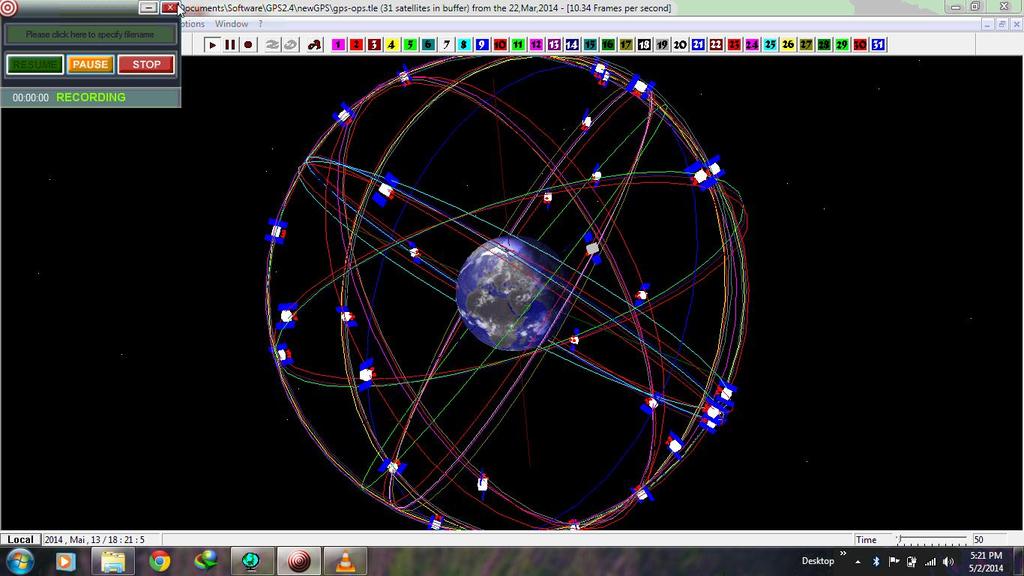
2 Introduction Emerging applications of location based solutions automobiles, location based ads, emergency services, national security. Current operational systems GPS, GLONASS. Future Galileo, Compass, IRNSS Working principle Position calculation by trilateration from distances to four satellites.
3 Performance Parameters Availability Probability(4 satellites visible) GPS guarantees 95% (5 elev)- minimum usable Continuity Probability(4 sat remain visible) Accuracy of position solution. Depends on geometry of satellites (GDoP) Time To First Fix-Time from starting of receiver to first position solution.


4 Motivation Less availability of satellites at high elevation angles in urban areas. Current solutions QZSS, hybrid receiver. Disadvantages - Cost, limited area Proposed solution integrated receiver : multiple satellites; more availability, global system.
5 Availability Study Results Elevation Angle Global Average of Availability (GPS) Global Average of Availability (GPS + GLONASS) % 100% % 100% % 100% % 98.31% % 60.97% % 16.87% % 1.9%
6 Availability Map at 40 Elevation
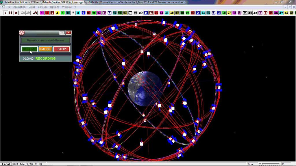
7 GNSS receiver advantages An integrated receiver will have Better Availability (4 out of 60 vs 4 out of 31) Better Continuity Better Accuracy (Select combination with minimum Geometric Dilution of Precision(GDoP)) Additional Integrity information (Identify combination containing malfunctioning satellite)

8 Problem Definition Many parts common with GPS receivers. Modifications to be made in other parts to meet unique GNSS challenges. We dealt with 2 main challenges -correlation receiver and PRN code loader
9 Correlation Receiver GNSS systems use CDMA system. Noise increases with number of satellites. Urban environments; multipath; low signal power and Carrier to Noise Ratio (CNR) Delay calculation erroneous at low CNR large error in range (factor c) Filter causes flatness near correlation peak Noise can cause nearby values to cross threshold. Parallel correlators Early, Late, Prompt required. (Early = Late etc.) Proposed and tested new discriminator (E-L) + (1-P) with good accuracy in low CNR
10 Correlation Receiver

11 Correlation Receiver BoC modulation requires very early and very late correlators too
12 Correlation Receiver Results Scheme Root Mean Square Error (chips) E-L Envelope norm 4.56 E-L Envelope 2.3 E-L Power 4.47 (E-L)/P 3.18 (E-L) + (1-P) 0.55
13 Time-To-First-Fix Hot Start knows last position, satellites, UTC Warm Start last position, almanac, UTC Cold Start Invalid Almanac and/or Changed position. Largest TTFF State of the Art Random Loading scheme Suffers more for multiple satellite systems Proposed and Tested new Algorithm Reduces TTFF by about 30%


14 Time-To-First-Fix First four satellites minimum overlap of footprints, well separated in 3D space Molecular geometry Tetrahedral arrangement of 4 satellites maximizes separation
15
16
17
18 Time-To-First-Fix Algorithm Step 1: Select 4 satellites from the constellation with minimum variance from tetrahedron Step 2: Select 2 satellites passing through coverage gap of previous 4 satellites, choose the best tetrahedron they form Step 3: Repeat from step 2 for n(sat)/4 times to get combinations till max iteration.
19 Coverage Map Iteration 1

20 Coverage Map Iteration 2
21 Iterations Required Number of Iterations required to reach 95% conditional probability Elevation Angle Algorithm It Random It Reduction (%) GPS (GPS + GLONASS)
22 Net Probability GPS + GLONASS performs better in net probability
23 Conclusions Quantitative results support the fact that including GLONASS increases availability at higher elevation angles Proposed and successfully tested new discriminator for accurate delay estimation in low CNR scenario Proposed and successfully tested new algorithm for reduced time to first fix in cold start
24 Future Directions Correction for ionospheric errors exploiting multi system constellation. GDoP minimization by optimum satellite geometry Inclusion of other systems Galileo, Compass
25 References GPS/GLONASS Interface Control Documents IS-GPS-200G IS-GPS-705C IS-GPS-800C ICD-GLONASS-5.1-(2008)
26 References Papers Satellite Orbits Based Sky Search by Maristella Musso, Gianluca Gera and Carlo S. Regazzoni. Propagating PZ 90 to WGS 84 Transformation Parameters by Yuri A. Bazlov, Viktor F Galazin, Boris L. Kaplan, Valery G Maksimov, Vladimir P Rogozin
27 References Websites Professor Wolfgang Soll s website, containing the GPS 25 software NORAD Two Line Element Sets for GPS, GLONASS and other systems Books Understanding GPS: Principles and Applications bye.d Kaplan and C.J Hegarty

28
DESIGN AND IMPLEMENTATION OF GLOBAL NAVIGATION SATELLITE SYSTEM (GNSS) RECEIVER. Final Report of BTech Project
 RECEIVER. Final Report of BTech Project") Indian Institute of Technology Jodhpur DESIGN AND IMPLEMENTATION OF GLOBAL NAVIGATION SATELLITE SYSTEM (GNSS) RECEIVER Final Report of BTech Project Submitted by Aswin Suresh, Arun Balajee V and Mahesh
Indian Institute of Technology Jodhpur DESIGN AND IMPLEMENTATION OF GLOBAL NAVIGATION SATELLITE SYSTEM (GNSS) RECEIVER Final Report of BTech Project Submitted by Aswin Suresh, Arun Balajee V and Mahesh
DESIGN AND IMPLEMENTATION OF INTEGRATED GLOBAL NAVIGATION SATELLITE SYSTEM (GNSS) RECEIVER. B.Tech Thesis Report
 RECEIVER. B.Tech Thesis Report") Indian Institute of Technology Jodhpur DESIGN AND IMPLEMENTATION OF INTEGRATED GLOBAL NAVIGATION SATELLITE SYSTEM (GNSS) RECEIVER B.Tech Thesis Report Submitted by Arun Balajee V, Aswin Suresh and Mahesh
Indian Institute of Technology Jodhpur DESIGN AND IMPLEMENTATION OF INTEGRATED GLOBAL NAVIGATION SATELLITE SYSTEM (GNSS) RECEIVER B.Tech Thesis Report Submitted by Arun Balajee V, Aswin Suresh and Mahesh
King AbdulAziz University. Faculty of Environmental Design. Geomatics Department. Mobile GIS GEOM 427. Lecture 3
 King AbdulAziz University Faculty of Environmental Design Geomatics Department Mobile GIS GEOM 427 Lecture 3 Ahmed Baik, Ph.D. Email: abaik@kau.edu.sa Eng. Fisal Basheeh Email: fbasaheeh@kau.edu.sa GNSS
Introduction to Global Navigation Satellite System (GNSS) Signal Structure
 Signal Structure") Introduction to Global Navigation Satellite System (GNSS) Signal Structure Dinesh Manandhar Center for Spatial Information Science The University of Tokyo Contact Information: dinesh@iis.u-tokyo.ac.jp
Introduction to Global Navigation Satellite System (GNSS) Signal Structure Dinesh Manandhar Center for Spatial Information Science The University of Tokyo Contact Information: dinesh@iis.u-tokyo.ac.jp
Report of the Working Group B: Enhancement of Global Navigation Satellite Systems (GNSS) Services Performance
 Services Performance") Report of the Working Group B: Enhancement of Global Navigation Satellite Systems (GNSS) Services Performance 1. The Working Group on Enhancement of Global Navigation Satellite Systems (GNSS) Service Performance
Report of the Working Group B: Enhancement of Global Navigation Satellite Systems (GNSS) Services Performance 1. The Working Group on Enhancement of Global Navigation Satellite Systems (GNSS) Service Performance
Benefits of amulti-gnss Receiver inaninterference Environment
 Benefits of amulti-gnss Receiver inaninterference Environment Ulrich Engel Fraunhofer Institute for Communication, Information Processing and Ergonomics FKIE Department Sensor Data and Information Fusion
Mobile Positioning in Wireless Mobile Networks
 Mobile Positioning in Wireless Mobile Networks Peter Brída Department of Telecommunications and Multimedia Faculty of Electrical Engineering University of Žilina SLOVAKIA Outline Why Mobile Positioning?
Understanding GPS: Principles and Applications Second Edition
 Understanding GPS: Principles and Applications Second Edition Elliott Kaplan and Christopher Hegarty ISBN 1-58053-894-0 Approx. 680 pages Navtech Part #1024 This thoroughly updated second edition of an
GPS Time Synchronization with World-Class Accuracy using a Few Selected Satellites
 October 23, 2018 Nippon Telegraph and Telephone Corporation FURUNO ELECTRIC CO., LTD. GPS Time Synchronization with World-Class Accuracy using a Few Selected Satellites Multi-path-tolerant GNSS receiver
Foreword by Glen Gibbons About this book Acknowledgments List of abbreviations and acronyms List of definitions
 Table of Foreword by Glen Gibbons About this book Acknowledgments List of abbreviations and acronyms List of definitions page xiii xix xx xxi xxv Part I GNSS: orbits, signals, and methods 1 GNSS ground
Signals, and Receivers
 ENGINEERING SATELLITE-BASED NAVIGATION AND TIMING Global Navigation Satellite Systems, Signals, and Receivers John W. Betz IEEE IEEE PRESS Wiley CONTENTS Preface Acknowledgments Useful Constants List of
Resection. We can measure direction in the real world! Lecture 10: Position Determination. Resection Example: Isola, Slovenia. Professor Keith Clarke
 Geography 12: Maps and Spatial Reasoning Lecture 10: Position Determination We can measure direction in the real world! Professor Keith Clarke Resection Resection Example: Isola, Slovenia Back azimuth
Where Next for GNSS?
 Where Next for GNSS? Professor Terry Moore Professor of Satellite Navigation Nottingham The University of Nottingham Where Next for GNSS Back to the Future? Professor Terry Moore Professor of Satellite
Intro to GNSS & Teseo-LIV3F Module for IoT Positioning
 Intro to GNSS & Teseo-LIV3F Module for IoT Positioning Agenda 2 Presentation Speaker GPS Signal Overview GNSS Constellations Mike Slade Teseo3 Chipset Overview Multi-Constellation Benefit Teseo-LIV3F Module
GNSS Technologies. GNSS Acquisition Dr. Zahidul Bhuiyan Finnish Geospatial Research Institute, National Land Survey
 GNSS Acquisition 25.1.2016 Dr. Zahidul Bhuiyan Finnish Geospatial Research Institute, National Land Survey Content GNSS signal background Binary phase shift keying (BPSK) modulation Binary offset carrier
Dynamic Reconfiguration in a GNSS Software Defined Radio for Multi-Constellation Operation
 Dynamic Reconfiguration in a GNSS Software Defined Radio for Multi-Constellation Operation Alison K. Brown and D Arlyn Reed, NAVSYS Corporation BIOGRAPHY Alison Brown is the President and Chief Executive
New Signal Structures for BeiDou Navigation Satellite System
 Stanford's 2014 PNT Symposium New Signal Structures for BeiDou Navigation Satellite System Mingquan Lu, Zheng Yao Tsinghua University 10/29/2014 1 Outline 1 Background and Motivation 2 Requirements and
Supplement to. Global navigation satellite systems (GNSS) L E C T U R E. Zuzana Bělinová. TELEMATIC SYSTEMS AND THEIR DESIGN part Systems Lecture 5
 L E C T U R E. Zuzana Bělinová. TELEMATIC SYSTEMS AND THEIR DESIGN part Systems Lecture 5") Zuzana Bělinová L E C T U R E 5 Supplement to Global navigation satellite systems (GNSS) Recapitulation Satellite navigation systems Zuzana Bělinová History of satellite navigation USA USA 1960 TRANSIT
Zuzana Bělinová L E C T U R E 5 Supplement to Global navigation satellite systems (GNSS) Recapitulation Satellite navigation systems Zuzana Bělinová History of satellite navigation USA USA 1960 TRANSIT
GNSS Signal Structures
 GNSS Signal Structures Tom Stansell Stansell Consulting Tom@Stansell.com Bangkok, Thailand 23 January 2018 S t a n s e l l C o n s u l t i n g RL Introduction It s a pleasure to speak with you this morning.
Effect of Quasi Zenith Satellite (QZS) on GPS Positioning
 on GPS Positioning") Effect of Quasi Zenith Satellite (QZS) on GPS ing Tomoji Takasu 1, Takuji Ebinuma 2, and Akio Yasuda 3 Laboratory of Satellite Navigation, Tokyo University of Marine Science and Technology 1 (Tel: +81-5245-7365,
Effect of Quasi Zenith Satellite (QZS) on GPS ing Tomoji Takasu 1, Takuji Ebinuma 2, and Akio Yasuda 3 Laboratory of Satellite Navigation, Tokyo University of Marine Science and Technology 1 (Tel: +81-5245-7365,
DYNAMIC POSITIONING CONFERENCE October 7-8, Sensors II. Redundancy in Dynamic Positioning Systems Based on Satellite Navigation
 Return to Session Directory DYNAMIC POSITIONING CONFERENCE October 7-8, 2008 Sensors II Redundancy in Dynamic Positioning Systems Based on Satellite Navigation Ole Ørpen, Tor Egil Melgård, Arne Norum Fugro
Assessment of GNSS Ionospheric Scintillation and TEC Monitoring Using the Multi-constellation GPStation-6 Receiver
 Assessment of GNSS Ionospheric Scintillation and TEC Monitoring Using the Multi-constellation GPStation-6 Receiver Rod MacLeod Regional Manager Asia/Pacific NovAtel Australia Pty Ltd Outline Ionospheric
GNSS Accuracy Improvements through Multipath Mitigation with New Signals and services
 GNSS Accuracy Improvements through Multipath Mitigation with New Signals and services Andrey Veytsel, Ph.D Moscow Technical University 10 Meeting of the International Committee on Global Navigation Satellite
Signal Quality Monitoring. Authors: Yury Yaskin, General Director, Chief designer. Valeriy Tyubalin, Deputy Chief designer
 Signal Quality Monitoring Authors: Yury Yaskin, General Director, Chief designer. Valeriy Tyubalin, Deputy Chief designer ICG-7 Meeting, Beijing, China, 4-9 November 2012 Avnues of development: 1. Controlling
Future GNSS: Improved Signals and Constellations
 Future GNSS: Improved Signals and Constellations Guillermo Martínez Morán 1 1 Airbus Defense & Space. Paseo John Lennon s/n 28096 Getafe (Madrid Spain) Guillermo.M.Martinez@military.airbus.com Abstract:
A FAMILY OF SOLUTIONS BASED ON THE srx-10, A SW DEFINED MULTICONSTELLATION GNSS RECEIVER
 ION GNSS+ 2014, Session A5 A FAMILY OF SOLUTIONS BASED ON THE srx-10, A SW DEFINED MULTICONSTELLATION GNSS RECEIVER Teresa Ferreira, Manuel Toledo, José María López, GMV Property of GMV All rights reserved
Global Navigation Satellite Systems II
 Global Navigation Satellite Systems II AERO4701 Space Engineering 3 Week 4 Last Week Examined the problem of satellite coverage and constellation design Looked at the GPS satellite constellation Overview
How Effective Are Signal. Quality Monitoring Techniques
 How Effective Are Signal Quality Monitoring Techniques for GNSS Multipath Detection? istockphoto.com/ppampicture An analytical discussion on the sensitivity and effectiveness of signal quality monitoring
The Influence of Multipath on the Positioning Error
 The Influence of Multipath on the Positioning Error Andreas Lehner German Aerospace Center Münchnerstraße 20 D-82230 Weßling, Germany andreas.lehner@dlr.de Co-Authors: Alexander Steingaß, German Aerospace
BeiDou Next Generation Signal Design and Expected Performance
 International Technical Symposium on Navigation and Timing ENAC, 17 Nov 2015 BeiDou Next Generation Signal Design and Expected Performance Challenges and Proposed Solutions Zheng Yao Tsinghua University
GPS (Introduction) References. Terms
 References. Terms") GPS (Introduction) WCOM2, GPS, 1 Terms NAVSTAR GPS ( Navigational Satellite Timing and Ranging - Global Positioning System) is a GNSS (Global Navigation Satellite System), developed by the US-DoD in 197x
GPS (Introduction) WCOM2, GPS, 1 Terms NAVSTAR GPS ( Navigational Satellite Timing and Ranging - Global Positioning System) is a GNSS (Global Navigation Satellite System), developed by the US-DoD in 197x
On the coexistence of satellite UMTS. and Galileo with SDR receiver
 SDR Forum Technical Conference Phoenix, 15-18 November 2004 On the coexistence of satellite UMTS and Galileo with SDR receiver Maristella Musso Gianluca Gera Carlo S. Regazzoni Matteo Gandetto DIBE Department
Politecnico di Torino. Porto Institutional Repository
 Politecnico di Torino Porto Institutional Repository [Article] A mass-market Galileo receiver: Its algorithms and performance Original Citation: Linty N., Crosta P., Mattos P., Pisoni F. (214). A mass-market
GPS (Introduction) References. Terms
 References. Terms") GPS (Introduction) MSE, Rumc, GPS, 1 Terms NAVSTAR GPS ( Navigational Satellite Timing and Ranging - Global Positioning System) is a GNSS (Global Navigation Satellite System), developed by the US-DoD in
GPS (Introduction) MSE, Rumc, GPS, 1 Terms NAVSTAR GPS ( Navigational Satellite Timing and Ranging - Global Positioning System) is a GNSS (Global Navigation Satellite System), developed by the US-DoD in
Future GNSS Precision Applications. Stuart Riley
 Future GNSS Precision Applications Stuart Riley Major Trimble Precision Markets Survey Mostly person portable equipment Construction Machine control and person carried equipment Includes Marine applications
GPS and Recent Alternatives for Localisation. Dr. Thierry Peynot Australian Centre for Field Robotics The University of Sydney
 GPS and Recent Alternatives for Localisation Dr. Thierry Peynot Australian Centre for Field Robotics The University of Sydney Global Positioning System (GPS) All-weather and continuous signal system designed
Introduction to the Global Positioning System
 GPS for Fire Management - 2004 Introduction to the Global Positioning System Pre-Work Pre-Work Objectives Describe at least three sources of GPS signal error, and identify ways to mitigate or reduce those
Contribution of the Compass satellite navigation system to global PNT users
 Article Geophysics September 2011 Vol.56 No.26: 28132819 doi: 10.1007/s11434-011-4627-4 SPECIAL OPICS: Contribution of the Compass satellite navigation system to global PN users YANG Yuani 1*, LI JinLong
GLOBAL POSITIONING SYSTEMS. Knowing where and when
 GLOBAL POSITIONING SYSTEMS Knowing where and when Overview Continuous position fixes Worldwide coverage Latitude/Longitude/Height Centimeter accuracy Accurate time Feasibility studies begun in 1960 s.
Integrity of Satellite Navigation in the Arctic
 Integrity of Satellite Navigation in the Arctic TODD WALTER & TYLER REID STANFORD UNIVERSITY APRIL 2018 Satellite Based Augmentation Systems (SBAS) in 2018 2 SBAS Networks in 2021? 3 What is Meant by Integrity?
Shadow Matching: A New GNSS Positioning Technique for Urban Canyons
 THE JOURNAL OF NAVIGATION (2011), 64, 417 430. doi:10.1017/s0373463311000087 f The Royal Institute of Navigation Shadow Matching: A New GNSS Positioning Technique for Urban Canyons Paul D. Groves (University
Benefits of combining systems The Receiver s Perspective Dr Philip G Mattos
 Benefits of combining systems The Receiver s Perspective Dr Philip G Mattos October 2011 Contents Who we are What s missing in GPS alone Other constellations available Improving GPS only receivers Add
Introduction to Geographic Information Science. Last Lecture. Today s Outline. Geography 4103 / GNSS/GPS Technology
 Geography 4103 / 5103 Introduction to Geographic Information Science GNSS/GPS Technology Last Lecture Geoids Ellipsoid Datum Projection Basics Today s Outline GNSS technology How satellite based navigation
GNSS Modernisation and Its Effect on Surveying
 Lawrence LAU and Gethin ROBERTS, China/UK Key words: GNSS Modernisation, Multipath Effect SUMMARY GPS and GLONASS modernisation is being undertaken. The current GPS modernisation plan is expected to be
Multisystem Real Time Precise-Point-Positioning, today with GPS+GLONASS in the near future also with QZSS, Galileo, Compass, IRNSS
 2 International Symposium on /GNSS October 26-28, 2. Multisystem Real Time Precise-Point-Positioning, today with +GLONASS in the near future also with QZSS, Galileo, Compass, IRNSS Álvaro Mozo García,
Challenges and Solutions for GPS Receiver Test
 Challenges and Solutions for GPS Receiver Test Presenter: Mirin Lew January 28, 2010 Agenda GPS technology concepts GPS and GNSS overview Assisted GPS (A-GPS) Basic tests required for GPS receiver verification
L76-L GNSS Module Presentation
 L76-L GNSS Module Presentation May, 2016 Quectel Wireless Solutions Co., Ltd. All rights reserved www.quectel.com Contents Highlights Advanced Features Quectel L76-L vs. Competitor s Product Support Package
Report on a Multi-GNSS Demonstration project in the Asia/Oceania region
 Report on a Multi-GNSS Demonstration project in the Asia/Oceania region - Asia Oceania is the Showcase of New GNSS Era - Japan Aerospace Exploration Agency ICG 5@Turin, Italy October 19, 2010 1 Back Ground
A Slope-Based Multipath Estimation Technique for Mitigating Short-Delay Multipath in GNSS Receivers
 Copyright Notice c 2010 IEEE. Personal use of this material is permitted. However, permission to reprint/republish this material for advertising or promotional purposes or for creating new collective works
The Case for Recording IF Data for GNSS Signal Forensic Analysis Using a SDR
 The Case for Recording IF Data for GNSS Signal Forensic Analysis Using a SDR Professor Gérard Lachapelle & Dr. Ali Broumandan PLAN Group, University of Calgary PLAN.geomatics.ucalgary.ca IGAW 2016-GNSS
GPS + Glonass Using the Best of Both Worlds
 GPS + Glonass Using the Best of Both Worlds Jupiter SL869 Jupiter JN3 Jupiter SE880 IMPROVE TIME-TO-FIRST-FIX GET MORE ACCURATE POSITIONING ENHANCE TIME IN NAVIGATION COLLECT MOST RELIABLE PROBE-DATA TABLE
Prospect for Global Positioning Augmentation Service by QZSS
 Prospect for Global Positioning Augmentation Service by QZSS Global Positioning Augmentation Service Corporation Director, Yoshikatsu Iotake Feb. 6, 2018 Copyright 2018 Global Positioning Augmentation
TEST YOUR SATELLITE NAVIGATION PERFORMANCE ON YOUR ANDROID DEVICE GLOSSARY
 TEST YOUR SATELLITE NAVIGATION PERFORMANCE ON YOUR ANDROID DEVICE GLOSSARY THE GLOSSARY This glossary aims to clarify and explain the acronyms used in GNSS and satellite navigation performance testing
Sources of Error in Satellite Navigation Positioning
 http://www.transnav.eu the International Journal on Marine Navigation and Safety of Sea Transportation Volume 11 Number 3 September 2017 DOI: 10.12716/1001.11.03.04 Sources of Error in Satellite Navigation
Experiences with Fugro's Real Time GPS/GLONASS Orbit/Clock Decimeter Level Precise Positioning System
 Return to Session Directory DYNAMIC POSITIONING CONFERENCE October 13-14, 2009 Sensors Experiences with Fugro's Real Time GPS/GLONASS Orbit/Clock Decimeter Level Precise Positioning System Ole Ørpen and
RECEIVER DEVELOPMENT, SIGNALS, CODES AND INTERFERENCE
 Presentation for: 14 th GNSS Workshop November 01, 2007 Jeju Island, Korea RECEIVER DEVELOPMENT, SIGNALS, CODES AND INTERFERENCE Stefan Wallner, José-Ángel Ávila-Rodríguez, Guenter W. Hein Institute of
GNSS Technologies. Introduction to GNSS technologies, Dr. Laura Ruotsalainen
 GNSS Technologies Introduction to GNSS technologies, 11.1.2016 Dr. Laura Ruotsalainen Finnish Geospatial Research Institute, National Land Survey / Aalto University, School of Engineering, Department of
3GPP TS V ( )
") TS 25.172 V10.2.0 (2011- Technical Specification 3rd Generation Partnership Project; Technical Specification Group Radio Access Network; Requirements for support of Assisted Galileo and Additional Navigation
TS 25.172 V10.2.0 (2011- Technical Specification 3rd Generation Partnership Project; Technical Specification Group Radio Access Network; Requirements for support of Assisted Galileo and Additional Navigation
TREBALL DE FI DE CARRERA
 TREBALL DE FI DE CARRERA TFC TITLE: Positioning in urban environments DEGREE: Master in Aerospace Science and Technology AUTHOR: Jan Sanromà Sánchez ADVISOR: Jaume Sanz SUPERVISOR: Olivier Julien DATE:
Security of Global Navigation Satellite Systems (GNSS) GPS Fundamentals GPS Signal Spoofing Attack Spoofing Detection Techniques
 GPS Fundamentals GPS Signal Spoofing Attack Spoofing Detection Techniques") Security of Global Navigation Satellite Systems (GNSS) GPS Fundamentals GPS Signal Spoofing Attack Spoofing Detection Techniques Global Navigation Satellite Systems (GNSS) Umbrella term for navigation
Security of Global Navigation Satellite Systems (GNSS) GPS Fundamentals GPS Signal Spoofing Attack Spoofing Detection Techniques Global Navigation Satellite Systems (GNSS) Umbrella term for navigation
Assessing & Mitigation of risks on railways operational scenarios
 R H I N O S Railway High Integrity Navigation Overlay System Assessing & Mitigation of risks on railways operational scenarios Rome, June 22 nd 2017 Anja Grosch, Ilaria Martini, Omar Garcia Crespillo (DLR)
Errors in GPS. Errors in GPS. Geodetic Co-ordinate system. R. Khosla Fall Semester
 Errors in GPS Errors in GPS GPS is currently the most accurate positioning system available globally. Although we are talking about extreme precision and measuring distances by speed of light, yet there
Challenges and Solutions for GPS Receiver Test
 Challenges and Solutions for GPS Receiver Test Presenter: Mirin Lew January 28, 2010 Agenda GPS technology concepts GPS and GNSS overview Assisted GPS (A-GPS) Basic tests required for GPS receiver verification
SPECIFICATION. GPS Receiver Module PMB-248 ISSUED DATE 2005/09/14 PUBLISHED BY VERSION 01 PAGE 2/7 PRODUCT NAME. Polstar Technologies Inc.
 PAGE 2/7 SPECIFICATION SPEC NO. : PMB-248 PART NO. : PMB-248 : GPS Receiver / PMB-248 DESCRIPTION : GPS Receiver (RS232,TTL, Baud Rate 4800bps) REVISION STATUS VERSION DATE PAGE REVISION DESCRIPTION PREPARED
Precise Point Positioning with BeiDou
 Precise Point Positioning with BeiDou Ole Ørpen Fugro Satellite Positioning AS Geodesi- og Hydrografidagene Stavanger, 12-13 Nov. 2014 Fugro 2013 Contents The G2 service Galileo Testing 2013 BeiDou Testing
GNSS Training for ITS Developers. 1 - GNSS Principles
 GNSS Training for ITS Developers 1 - GNSS Principles Table of Content Introduction to Satellite Navigation Systems Basics on GNSS Receivers Galileo, the European GNSS EGNOS, the European Augmentation System
GNSS Simulator in the R&S SMBV100A Vector Signal Generator Specifications
 GNSS Simulator in the R&S SMBV100A Vector Signal Generator Specifications Data Sheet Version 11.00 CONTENTS Definitions... 4 Overview... 5 Abbreviations... 5 Minimum hardware configuration... 6 Key features...
DYNAMICALLY RECONFIGURABLE SOFTWARE DEFINED RADIO FOR GNSS APPLICATIONS
 DYNAMICALLY RECONFIGURABLE SOFTWARE DEFINED RADIO FOR GNSS APPLICATIONS Alison K. Brown (NAVSYS Corporation, Colorado Springs, Colorado, USA, abrown@navsys.com); Nigel Thompson (NAVSYS Corporation, Colorado
Galileo System and Signal Evolution
 Galileo System and Signal Evolution Stefan Wallner GNSS/Galileo Evolutions Programme ITSNT, 15/11/2017 HOW TO DESIGN A GNSS SYSTEM FOR THE YEAR 2040 15/11/2017 Slide 2 Navigation Exponential Evolution
RNSSs Positioning in the Asia-Oceania Region
 RNSSs Positioning in the Asia-Oceania Region Binghao Li 1, Shaocheng Zhang 2, Andrew G Dempster 1 and Chris Rizos 1 1 School of Surveying and Spatial Information Systems, University of New South Wales,
ION GNSS Galileo, an ace up in the sleeve for PPP techniques
 ION GNSS+ 2016 an ace up in the sleeve for PPP techniques September 15 TH, 2016 Session D3: High Precision GNSS Positioning I. Rodríguez-Pérez, L. Martínez-Fernández, G. Tobías-González, J. D. Calle-Calle,
APPLICATION NOTE Fundamental GNSS
 APPLICATION NOTE Fundamental GNSS Receiver Characterisation Spirent Communications PLC Paignton, Devon, TQ4 7QR, England Web: http://www.spirent.com/positioning Tel: +44 1803 546325 Fax: +44 1803 546301
Bernhard Hofnlann-Wellenhof Herbert Lichtenegger Elmar Wasle. GNSS - Global Navigation Satellite Systenls. GPS, GLONASS, Galileo, and nl0re
 Bernhard Hofnlann-Wellenhof Herbert Lichtenegger Elmar Wasle GNSS - Global Navigation Satellite Systenls GPS, GLONASS, Galileo, and nl0re SpringerWienNewYork Contents Abbreviations xxi 1 Introduction 1
Satellite-Based Augmentation System (SBAS) Integrity Services
 Integrity Services") Satellite-Based Augmentation System (SBAS) Integrity Services Presented To: Munich, Germany Date: March 8, 2010 By: Leo Eldredge, Manager GNSS Group, FAA FAA Satellite Navigation Program 2 Wide Area Augmentation
Satellite-Based Augmentation System (SBAS) Integrity Services Presented To: Munich, Germany Date: March 8, 2010 By: Leo Eldredge, Manager GNSS Group, FAA FAA Satellite Navigation Program 2 Wide Area Augmentation
Global Navigation Satellite System (GNSS) for Disaster Mitigation
 for Disaster Mitigation") Global Navigation Satellite System (GNSS) for Disaster Mitigation By Chathura H. Wickramasinghe Geoinformatics Center Asian Institute of Technology Establish in 1959 as a Post Graduate School Catering
Global Navigation Satellite System (GNSS) for Disaster Mitigation By Chathura H. Wickramasinghe Geoinformatics Center Asian Institute of Technology Establish in 1959 as a Post Graduate School Catering
Positioning with Single and Dual Frequency Smartphones Running Android 7 or Later
 Positioning with Single and Dual Frequency Smartphones Running Android 7 or Later * René Warnant, *Laura Van De Vyvere, + Quentin Warnant * University of Liege Geodesy and GNSS + Augmenteo, Plaine Image,
Understanding GPS/GNSS
 Understanding GPS/GNSS Principles and Applications Third Edition Contents Preface to the Third Edition Third Edition Acknowledgments xix xxi CHAPTER 1 Introduction 1 1.1 Introduction 1 1.2 GNSS Overview
The Indian Regional Navigation. First Position Fix with IRNSS. Successful Proof-of-Concept Demonstration
 Successful Proof-of-Concept Demonstration First Position Fix with IRNSS A. S. GANESHAN, S. C. RATNAKARA, NIRMALA SRINIVASAN, BABU RAJARAM, NEETHA TIRMAL, KARTIK ANBALAGAN INDIAN SPACE RESEARCH ORGANISATION
Perspective of Eastern Global Satellite Navigation Systems
 POSTER 2015, PRAGUE MAY 14 1 Perspective of Eastern Global Satellite Navigation Systems Jiří SVATOŇ Dept. of Radioengineering, Czech Technical University, Technická 2, 166 27 Praha, Czech Republic svatoji2@fel.cvut.cz
The Benefits of Three Frequencies for the High Accuracy Positioning
 The Benefits of Three Frequencies for the High Accuracy Positioning Nobuaki Kubo (Tokyo University of Marine and Science Technology) Akio Yasuda (Tokyo University of Marine and Science Technology) Isao
The EU Satellite Navigation programmes status Applications for the CAP
 The EU Satellite Navigation programmes status Applications for the CAP Michaël MASTIER European Commission DG ENTR GP3 GNSS Applications, Security and International aspects GPS Workshop 2010 Montpellier
CH GPS/GLONASS/GALILEO/SBAS Signal Simulator. General specification Version 0.2 Eng. Preliminary
 CH-380 GPS/GLONASS/GALILEO/SBAS Signal Simulator General specification Version 0.2 Eng Preliminary Phone: +7 495 665 648 Fax: +7 495 665 649 navis@navis.ru NAVIS-UKRAINE Mazura str. 4 Smela, Cherkassy
DYNAMIC POSITIONING CONFERENCE October 7-8, Sensors I. Integrating Other GNSS with GPS and its Implication for DP Positioning
 Return to Session Directory DYNAMIC POSITIONING CONFERENCE October 7-8, 2008 Sensors I Integrating Other GNSS with GPS and its Implication for DP Positioning Dr. David Russell Veripos/Subsea 7 (Aberdeen,
Webinar. 9 things you should know about centimeter-level GNSS accuracy
 Webinar 9 things you should know about centimeter-level GNSS accuracy Webinar agenda 9 things you should know about centimeter-level GNSS accuracy 1. High precision GNSS challenges 2. u-blox F9 technology
Establishment of Regional Navigation Satellite System Utilizing Quasi-Zenith Satellite System
 Establishment of Regional Navigation Satellite System Utilizing Quasi-Zenith Satellite System Authors: Masayuki Saito*, Junichi Takiguchi* and Takeshi Okamoto* 1. Introduction The Global Navigation Satellite
Measuring Galileo s Channel the Pedestrian Satellite Channel
 Satellite Navigation Systems: Policy, Commercial and Technical Interaction 1 Measuring Galileo s Channel the Pedestrian Satellite Channel A. Lehner, A. Steingass, German Aerospace Center, Münchnerstrasse
Study of GPS Scintillation during Solar Maximum at Malaysia
 1 st International Conference of Recent Trends in Information and Communication Technologies Study of GPS Scintillation during Solar Maximum at Malaysia Emad Fathi Aon 1,2*, Redhwan Qasem Shaddad 3,4,Abdul
GPS for. Land Surveyors. Jan Van Sickle. Fourth Edition. CRC Press. Taylor & Francis Group. Taylor & Francis Croup, an Informa business
 GPS for Land Surveyors Fourth Edition Jan Van Sickle CRC Press Taylor & Francis Group Boca Raton London New York CRC Press is an imprint of the Taylor & Francis Croup, an Informa business Contents Preface
t =1 Transmitter #2 Figure 1-1 One Way Ranging Schematic
 1.0 Introduction OpenSource GPS is open source software that runs a GPS receiver based on the Zarlink GP2015 / GP2021 front end and digital processing chipset. It is a fully functional GPS receiver which
The Status of NAVIPEDIA
 The Status of NAVIPEDIA J. Ventura-Traveset, R. Lucas ICG 11, WG-C on Information Dissemination and Capacity Building Sochi, 8 November 2016 NAVIPEDIA: the GNSS wiki www.navipedia.org NAVIPEDIA: Mission
ETSI TS V ( )
") TS 125 172 V14.0.0 (2017-04) TECHNICAL SPECIFICATION Universal Mobile Telecommunications System (UMTS); Requirements for support of Assisted Galileo and Additional Navigation Satellite Systems (A-GANSS)
TS 125 172 V14.0.0 (2017-04) TECHNICAL SPECIFICATION Universal Mobile Telecommunications System (UMTS); Requirements for support of Assisted Galileo and Additional Navigation Satellite Systems (A-GANSS)
ANALYSIS OF GPS SATELLITE OBSERVABILITY OVER THE INDIAN SOUTHERN REGION
 TJPRC: International Journal of Signal Processing Systems (TJPRC: IJSPS) Vol. 1, Issue 2, Dec 2017, 1-14 TJPRC Pvt. Ltd. ANALYSIS OF GPS SATELLITE OBSERVABILITY OVER THE INDIAN SOUTHERN REGION ANU SREE
Global Navigation Satellite Systems (GNSS)Part I EE 570: Location and Navigation
Part I EE 570: Location and Navigation") Lecture Global Navigation Satellite Systems (GNSS)Part I EE 570: Location and Navigation Lecture Notes Update on April 25, 2016 Aly El-Osery and Kevin Wedeward, Electrical Engineering Dept., New Mexico
Lecture Global Navigation Satellite Systems (GNSS)Part I EE 570: Location and Navigation Lecture Notes Update on April 25, 2016 Aly El-Osery and Kevin Wedeward, Electrical Engineering Dept., New Mexico
Demonstrations of Multi-Constellation Advanced RAIM for Vertical Guidance using GPS and GLONASS Signals
 Demonstrations of Multi-Constellation Advanced RAIM for Vertical Guidance using GPS and GLONASS Signals Myungjun Choi, Juan Blanch, Stanford University Dennis Akos, University of Colorado Boulder Liang
GNSS 101 Bringing It Down To Earth
 GNSS 101 Bringing It Down To Earth Steve Richter Frontier Precision, Inc. UTM County Coordinates NGVD 29 State Plane Datums Scale Factors Projections Session Agenda GNSS History & Basic Theory Coordinate
The Role of F.I.G. in Leading the Development of International Real-Time Positioning Guidelines
 The Role of F.I.G. in Leading the Development of International Real-Time Positioning Guidelines, USA Key Words: RTN, real-time, GNSS, Guidelines SUMMARY The rapid growth of real-time reference station
Field experience with future GNSS ranging signals (a review). A.Simsky, J.-M. Sleewaegen, W. De Wilde Septentrio, Belgium
. A.Simsky, J.-M. Sleewaegen, W. De Wilde Septentrio, Belgium") Field experience with future GNSS ranging signals (a review). A.Simsky, J.-M. Sleewaegen, W. De Wilde Septentrio, Belgium Technical University of Munich June 07 2010 Contents Septentrio: company profile
Field experience with future GNSS ranging signals (a review). A.Simsky, J.-M. Sleewaegen, W. De Wilde Septentrio, Belgium Technical University of Munich June 07 2010 Contents Septentrio: company profile
2. GPS and GLONASS Basic Facts
 2. GPS and GLONASS Basic Facts In 1973 the U.S. Department of Defense decided to establish, develop, test, acquire, and deploy a spaceborne Global Positioning System (GPS). The result of this decision
High Precision Applications with BeiDou
 High Precision Applications with BeiDou Lei HUANG Unicore Communications, Inc May 14, 2013 Contents 1 2 3 4 Background Overview of BeiDou high precision products Applications of BeiDou high precision products
Asian Journal of Science and Technology Vol. 08, Issue, 11, pp , November, 2017 RESEARCH ARTICLE
 Available Online at http://www.journalajst.com ASIAN JOURNAL OF SCIENCE AND TECHNOLOGY ISSN: 0976-3376 Asian Journal of Science and Technology Vol. 08, Issue, 11, pp.6697-6703, November, 2017 ARTICLE INFO