No MAY 2010 UNITED STATES OF AMERICA. Contents
|
|
|
- Clemence Robbins
- 5 years ago
- Views:
Transcription


1 19 8 MAY 2010 UNITED STATES OF AMERICA Published Weekly by the National Geospatial-Intelligence Agency Prepared Jointly with the National Ocean Service and U.S. Coast Guard Contents Section I Corrections I-1.1 lets / Depth Tabulations / Notes I-2.1 s Affected by Mariners I-3.1 Section II NGA / DLIS Catalog Corrections II-1.1 Navigation Publications Corrections II-2.1 USCG Light List Corrections / Radiobeacon Corrections II-3.1 NGA List of Lights / Radiobeacon / DGPS Corrections II-4.1 Publications Affected by Mariners II-5.1 Section III Broadcast Warnings / MARAD Advisories / Special Warnings III-1.1 Marine Information III-2.1 Visit the Maritime Safety Web site at
2 IMPORTANT INFORMATION The Mariners is published by the National Geospatial-Intelligence Agency (NGA), under the authority of Department of Defense Directive , to advise mariners of important matters affecting navigational safety, including new hydrographic discoveries, changes in channels and navigational aids, etc. (U.S. Code Title 10, Sec. 442 and Title 44, Sec refer). Nothing in the arrangement of information implies endorsement or acceptance by NGA in matters affecting the status and boundaries of States and territories. The Mariners presents corrective information affecting charts, NGA/DLIS Catalog of Maps s and Related Products, Coast Pilots, Sailing Directions, Fleet Guides, USCG Light Lists, NGA List of Lights, Radio Navigational Aids and other products produced by the National Geospatial-Intelligence Agency, National Ocean Service and U.S. Coast Guard. Information for the Mariners is contributed by the following Agencies: National Geospatial-Intelligence Agency (NGA) (Department of Defense) for waters outside the territorial limits of the United States; National Ocean Service (NOS) (Department of Commerce), which is charged with the surveys and charting of the coasts and harbors of the United States and its territories; the U.S. Coast Guard (USCG) (Department of Homeland Security), which is responsible for the safety of life at sea and the establishment and operation of aids to navigation; and the U.S. Army Corps of Engineers (Department of Defense), which is charged with the improvement of rivers and harbors of the United States. In addition, important contributions are made by foreign hydrographic offices and cooperating observers of all nationalities. For further information concerning NGA hydrographic products and services, including the Maritime Safety Web site, users may contact: Name Telephone DSN FAX Maritime Domain World Wide Navigational Warning Service Maritime Safety Web site Mariners: Regions 1 and Mariners: Regions 3 thru Sailing Directions, Fleet Guides Navigation Publications DLA Catalog of Maps s and Related Products The Maritime Safety Web site can be accessed directly at For your convenience NGA provides four addresses. For information affecting Mariners use NavNotices@nga.mil, for information affecting Sailing Directions and all other navigational publications use MCDPubs@nga.mil, for information concerning the Maritime Safety Web site, use webmaster_nss@nga.mil and for information concerning the World Wide Navigational Warning Service, use NavSafety@nga mil. Mariners are requested to notify NGA of discrepancies in charts and publications, using the Marine Information Report and Suggestion Sheet at the back of this Mariners. This form should also be used to report permanent changes, additions, or deletions from charted or published information. Reports which constitute an immediate hazard to navigation should be sent to the nearest NAVAREA Coordinator via coast radio stations. All reports are greatly appreciated. Marine Information Report and Suggestion sheets received during the past week were submitted by the following observers: Observer Second Officer Ryan Arnold Ship/Organization USNS RICHARD G. MATTHIESEN Cover Photo: F/V CORNELIA MARIE is a U.S. registered fishing vessel originally built in Bayou La Batre, Alabama in 1989, with an extension of 21 feet added to the hull in The vessel is now 128 feet in length, has a beam of 28 feet, draft of 11.7 feet and displaces 298 gross tons. Powered by twin 630 horsepower diesel engines, CORNELIA MARIE carries 25, 800 gallons of fuel and has 7,500 gallons of fresh catch storage space available. With a crew of six, she is routinely engaged in the Alaskan King Crab and Opilio Crab fisheries in the Bering Sea. She is named after Cornelia Marie Devlin, an owner of the vessel, and is homeported in Kodiak, Alaska. ii
3 INFORMATION OF SPECIAL INTEREST OR IMPORTANCE TO MARINERS NM National Geospatial-Intelligence Agency Bethesda, MD SPECIAL ANNOUNCEMENTS NEW PRODUCTS OR SERVICES IMPORTANT CHANGES 8 May 2010 NGA CHART NEW EDITIONS AND THEIR AVAILABILITY NGA RECOGNIZES TWO PAPER NAUTICAL CHART PRODUCTS: ENTERPRISE PRODUCT ON DEMAND-MARITIME (EPOD-M) CHARTS AND TRADITIONAL NGA PAPER CHARTS. FOR ADDITIONAL INFORMATION, SEE SECTIONS II AND III. NEW EDITION OF SAILING DIRECTIONS PUB. 192, SAILING DIRECTIONS (ENROUTE) NORTH SEA, THIRTEENTH EDITION, 2010, IS AVAILABLE AT THE MARITIME SAFETY WEB SITE. THIS EDITION IS PRODUCED BY NGA IN DIGITAL FORMAT ONLY. SEE SECTIONS II AND III. NEW EDITION OF COAST PILOT U.S. COAST PILOT 1, ATLANTIC COAST: EASTPORT, ME TO CAPE COD, MA, FORTIETH EDITION, 2010, IS READY FOR ISSUE. SEE SECTIONS II AND III. NATIONAL GEOSPATIAL-INTELLIGENCE AGENCY S IMPLEMENTATION OF A HARDCOPY TO DIGITAL TRANSITION STRATEGY THIS NOTICE IS A REMINDER OF THE NATIONAL GEOSPATIAL-INTELLIGENCE AGENCY (NGA) HARDCOPY TO DIGITAL TRANSITION PROGRAM. SEE SECTION III FOR DETAILS. iii
4 EXPLANATION OF CONTENTS The Mariners contains corrective information affecting nautical charts, the NGA/DLIS Catalog of Maps s and Related Products, Coast Pilots, Sailing Directions, Fleet Guides, USCG Light Lists, NGA List of Lights, Radio Navigational Aids and other related nautical publications. The information contained in these corrections is important to safe navigation. It is the user s responsibility to decide which of their charts and publications require correction. Consult the U.S. Coast Guard Local Mariners for information pertaining to waterways within the United States that are not normally used by oceangoing vessels. Because of the sometimes transitory nature of aids to navigation, depths and port information, local area sources should be consulted whenever possible. This publication is not required to be maintained intact. Portions may be separated for correction or attachment to an affected product. The Mariners is divided into the following sections: Section I-1 contains corrections to nautical charts listed in numeric order by chart number. Each chart correction listed applies only to that particular chart. Related charts, if any, will have their own specific correction listed separately. Users should also refer to U.S. 1 Nautical Symbols, Abbreviations and Terms for additional information pertaining to the correcting of charts. The illustration below describes the elements that comprise a typical chart correction: International Series chart number U.S. number Edition number Edition date Last Mariners that affected chart Current Notice to Mariners TP (INT 1234) 1 1/23/98 LAST NM 12/00 27/00 Add Depth 12 meters Obstn [K41] N E (12(345)00 Taunton) Corrective action Source of information Object of correction 1 reference Position A chart correction preceded by: indicates that it is based upon original U.S. source information. T indicates that it is temporary in nature. P indicates that it is preliminary, and that permanent corrective action will appear in a future Mariners. The letter M immediately following the chart number indicates that the correction should be applied to the metric side of the chart only. The letter M is not a part of the chart number. The letter N preceding the current Mariners number indicates that the affected chart is on Limited Distribution and is normally only for use by U.S. Navy, government-owned or -chartered vessels. Courses and bearings are given in degrees true. Light sectors are expressed in degrees true from the vessel TOWARD the light. The visible range(s) listed for lights is normally the nominal range (the distance at which it can be seen in clear weather), expressed in nautical miles, except in the Great Lakes where it is expressed in statute miles. The colors of structures and lights of navigational aids are abbreviated in accordance with 1. Section I-2* contains all chartlets, depth tabulations and notes associated with the chart corrections in Section I-1. lets and depth tabulations supersede all previous information portrayed. Section I-3 lists all NGA and NOS charts which have been affected by Mariners and the notice numbers which have affected them since the date of the oldest Summary of Corrections or the chart s announcement, whichever is later. Section II-1 is a weekly listing of corrections to the NGA/DLIS Catalog of Maps s and Related Products, including new charts and publications. It also contains the latest price category information. Section II-2* contains corrections to navigation publications, including Sailing Directions, Coast Pilots, Fleet Guides, Radio Navigational Aids (Pub. 117), The American Practical Navigator and other related nautical publications. Section II-3* lists weekly updates to the USCG Light Lists. Section II-4* lists weekly updates to the NGA List of Lights. Section II-5 lists all NGA, NOS and USCG navigation publications which have been affected by Mariners and the notice numbers which have affected them since the date of the publication s announcement. Section III-1 lists the message number of all in-force Navigational Warnings, and the text of those warnings promulgated during the previous week. Mariners Nos. 13, 26 and 39 list a summary of all in-force Navigational Warnings for the preceding quarter. Mariners 52 lists a complete summary of all in-force Navigational Warnings. Section III-2 contains miscellaneous information of particular interest to the maritime community. *The left-hand pages of these sections are intentionally blank. iv
5 SECTION I NM CHART CORRECTIONS 509 (INT 509) 4 7/2/94 LAST NM 18/10 Delete R Bn at light N E (ROK CH 338) 1115A 11/08 LAST NM 16/10 Relocate Superbuoy ODAS from N W to N W (15/10 CG8) 1116A 8/09 LAST NM 17/10 Delete Dangerous wreck (PA) N W Dangerous wreck N W Danger circle Obstn (PA) N W Danger circle Obstn (PA) N W Danger circle Obstn (PA) N W Position circle Pile (PA) N W Dangerous wreck (PA) N W Dangerous wreck (PA) N W Dangerous wreck (PA) N W Danger circle Obstn (PA) N W Add Depth 13 feet Obstn [K41] N W (NOS) /09 LAST NM 16/10 Relocate Superbuoy ODAS from N W to N W (15/10 CG8) /08 LAST NM 16/10 Delete Buoy PM N W (14/10 CG8) /04 LAST NM 15/08 Delete Buoy PM N W (14/10 CG8) /06 LAST NM 35/06 (Side B) Delete Buoy PM N W (14/10 CG8) /09 LAST NM 16/10 Add Tabulation of controlling depths from Subsection I-2 (Supersedes 16/ ) (NOS) /09 LAST NM 16/10 Add Tabulation of controlling depths from Subsection I-2 (Supersedes 15/ ) (NOS) /08 LAST NM 16/10 Add Tabulation of controlling depths from Subsection I-2 (See 16/ ) (NOS) /09 LAST NM 17/10 Delete Dangerous wreck (PA) N W Dangerous wreck N W Danger circle Obstn (PA) N W Danger circle Obstn (PA) N W Danger circle Obstn (PA) N W Position circle Pile (PA) N W Dangerous wreck (PA) N W Dangerous wreck (PA) N W Dangerous wreck (PA) N W Danger circle Obstn (PA) N W Add Depth 13 feet Obstn [K41] N W (NOS) /07 LAST NM 16/10 Add Tabulation of controlling depths from Subsection I-2 (Supersedes 16/ ) (NOS) I /07 LAST NM 16/10 Delete Light (Fl 4s) N W Add Light Fl 2.5s 18ft (Priv) N W (14/10 CG8) /08 LAST NM 17/10 Add Platform [L10] N W Platform [L10] N W (14/10 CG8) /08 LAST NM 50/09 Delete Dangerous wreck (PA) N W Dangerous wreck N W Danger circle Obstn (PA) N W Danger circle Obstn rep (PA) N W Danger circle Obstn rep (PA) N W Danger circle Obstn (PA) N W Position circle Pile (PA) N W Dangerous wreck (PA) N W Dangerous wreck (PA) N W Add Depth 13 feet Obstn [K41] N W Position circle Pile [F22] N W Position circle Piles [F22] N W (NOS) /07 LAST NM 16/10 Delete Submerged well N W Dangerous wreck (PA) N W Dangerous wreck N W Danger circle Obstn (PA) N W Danger circle Obstn rep (PA) N W Danger circle Obstn rep (PA) N W Danger circle Obstn (PA) N W Position circle Pile (PA) N W Dangerous wreck (PA) N W Dangerous wreck (PA) N W Dangerous wreck (PA) N W Add Depth 13 feet Obstn [K41] N W Note: Platform close W remains Position circle Pile [F22] N W Position circle Piles [F22] N W Position circle Pile [F22] N W Position circle Pile [F22] N W Position circle Pile [F22] N W (NOS) /08 LAST NM 45/09 (Side B) Delete Danger circle Obstn (PA) N W Danger circle Obstn rep (PA) N W (NOS) /10 LAST NM 12/10 Add Platform [L10] N W (14/10 CG8) /08 LAST NM 17/10 Add Platform [L10] N W (14/10 CG8) /08 LAST NM 16/10 Relocate Superbuoy ODAS from N W to N W (15/10 CG8) /24/05 LAST NM N16/10 N Relocate Superbuoy ODAS from N W to N W (15/10 CG8) /10 LAST NM 18/10 Delete Superbuoy ODAS N W (15/10 CG8)
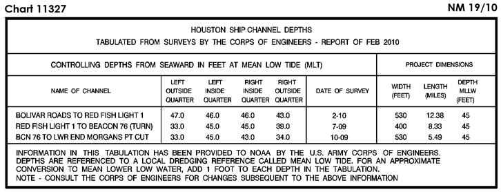
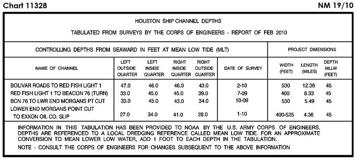
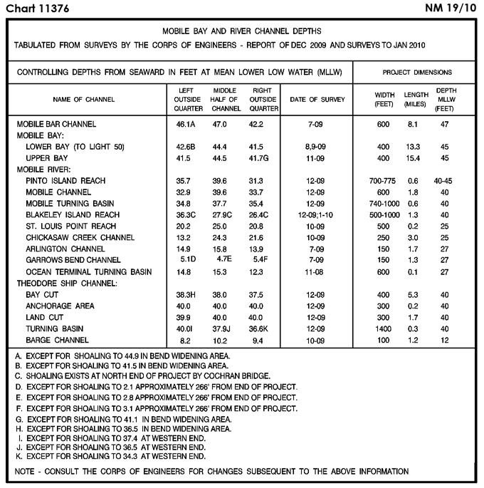
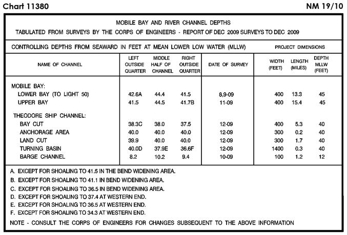
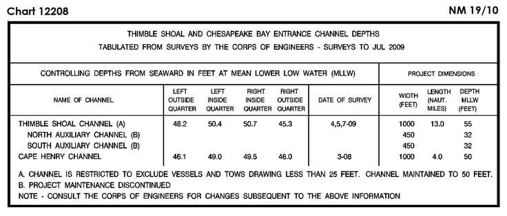
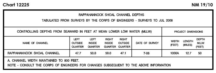
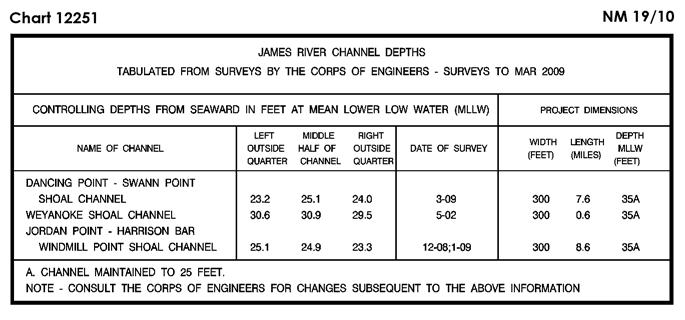
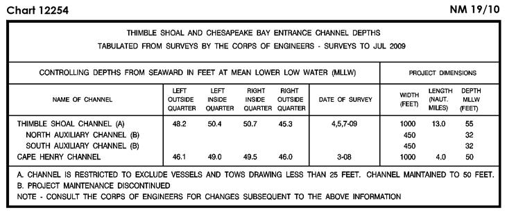
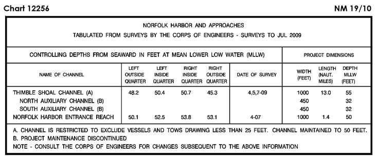
6 NM SECTION I /08 LAST NM 17/10 (Side A) Change Visibility (range) of light 142 to 5M N W Visibility (range) of light 146 to 5M N W (Side A, Continuation) Change Visibility (range) of light 163 to 5M N W (14/10 CG8) /09 LAST NM 17/10 Delete Superbuoy ODAS N W (15/10 CG8) /09 LAST NM 17/10 Add Tabulation of controlling depths from Subsection I-2 (See 17/ ) (Inset) Change Legend to 33 FT DEC 2009-JAN 2010 TURNING BASIN N W (NOS) /09 LAST NM 17/10 Add Tabulation of controlling depths from Subsection I-2 (Supersedes 17/ ) (NOS) /09 LAST NM 12/10 Delete Depth 28 feet N W Add Tabulation of controlling depths from Subsection I-2 Depth 23 feet Wk [K26] N W (NOS) /09 LAST NM 11/10 Add Tabulation of controlling depths from Subsection I-2 (NOS) /09 LAST NM 11/10 Add Tabulation of controlling depths from Subsection I-2 (NOS) /12/01 LAST NM 14/10 Delete Legend 23 FEET FOR A WIDTH OF 300 FEET SEP N W Legend 23 FEET FOR A WIDTH OF 300 FEET SEP N W Legend 25 FEET FOR WIDTH OF 300 FEET JAN N W Legend 25 FEET FOR WIDTH OF 300 FEET JAN N W /05 LAST NM 17/10 Add Tabulation of controlling depths from Subsection I-2 (Supersedes 17/ ) (NOS) /04 LAST NM 13/10 Add Depth 46 feet Obstn [K41] N W Depth 44 feet Obstn [K41] N W Depth 50 feet Obstn [K41] N W (NOS) /05 LAST NM 13/10 Delete BELL from buoy N W (15/10 CG8) /05 LAST NM 13/10 (Side B) Delete BELL from buoy N W (15/10 CG8) /10 NEW EDITION (NOS) /09 LAST NM 12/10 (Page A) Delete Depth 28 feet N W Add Depth 23 feet Wk [K26] N W (NOS) /09 LAST NM 12/10 Delete Depth 28 feet N W Add Tabulation of controlling depths from Subsection I-2 Depth 23 feet Wk [K26] N W (NOS) /09 LAST NM 12/10 Add Tabulation of controlling depths from Subsection I-2 Depth 23 feet Wk [K26] N W (NOS) Add (NOS) Legend 21 1 / 2 FEET FOR WIDTH OF 300 FEET JUN N W Legend 25 FEET BY 300 FT MAY N W Depth 19 feet N W Depth 19 feet N W Depth 20 feet N W Depth 23 feet N W Depth 27 feet N W Depth 27 feet N W Depth 29 feet N W Depth 29 feet N W Depth 30 feet N W Depth 30 feet N W (Supersedes 32/ ) Legend DANCING POINT-SWANN POINT SHOAL CHANNEL N W Legend JORDAN POINT-HARRISON BAR WINDMILL POINT SHOAL CHANNEL N W Legend WEYANOKE SHOAL CHANNEL N W Dashed line (channel limit) [I20] joining N W N W N W N W N W Dashed line (channel limit) [I20] joining N W N W N W N W N W N W Legend (see tab) N W Legend (see tabulation) N W Legend (see tabulation) N W Depth 16 feet N W Depth 19 feet N W Tabulation of controlling depths from Subsection I N W Note: First appearance of new depth tabulation on chart I-1.2
7 SECTION I NM /04 LAST NM 52/09 Change Legend 25 FT to (use chart 12251) N W (NOS) /09 LAST NM 32/09 Delete Depth 28 feet N W Add Tabulation of controlling depths from Subsection I-2 Depth 23 feet Wk [K26] N W (NOS) /09 LAST NM 32/09 Add Tabulation of controlling depths from Subsection I-2 (NOS) /07 LAST NM 4/10 Delete Light N W (14/10 CG5) /09 LAST NM 14/10 Delete Depth 28 feet N W Add Depth 23 feet Wk [K26] N W (NOS) /08 LAST NM 4/10 Relocate Buoy from N W to N W and change designation to F (See 39/ ) (11/10 CG1) /29/06 LAST NM N4/10 N Relocate Buoy from N W to N W and change designation to F (See N39/ ) (11/10 CG1) /08 LAST NM 11/10 (Upper Panel) Delete Range lights (2) and range line between N W N W (See 35/ ) Change Range light, rear to Oc 4s 45ft, Fl 4s 15ft 4M N W Add Range light, front Oc 4s 25ft N W Range light, rear F 52ft, 2 Fl 4s 15ft 4M N W (9/10 CG5) /09 LAST NM 5/10 (Side A) Add Tabulation of controlling depths from Subsection I-2 (NOS) /09 LAST NM 13/10 Delete Buoy N W Relocate Buoy from N W to N W and change designation to 32 (13/10 CG1) /09 LAST NM 4/10 Delete Buoy N W Relocate Buoy from N W to N W and change designation to 32 (13/10 CG1) /10 NEW EDITION (NOS) /09 LAST NM 13/10 Relocate Buoy from N W to N W and change designation to F (See 39/ ) (11/10 CG1) /09 LAST NM 6/10 Relocate Buoy F from N W to N W (11/10 CG1) /06 LAST NM 12/10 Delete Buoy NE N W Buoy NW N W Buoy SE N W Buoy SW N W (14/10 CG1) /07 LAST NM 12/10 Delete Buoy NE N W Buoy NW N W Buoy SE N W Buoy SW N W (14/10 CG1) /03 LAST NM 20/09 Delete Danger circle Obstn PA N W (NOS) /05 LAST NM 47/09 Delete Depth 34 feet N W Change Legend to 33 1 / 2 FT FOR A WIDTH OF 400 FT FEB 2005-JUL N W (NOS) /04 LAST NM 42/09 Delete Light N W (15/10 CG1) /14/01 LAST NM 42/09 Delete Light N W (15/10 CG1) /5/01 LAST NM 42/04 Delete Light N W (15/10 CG1) /05 LAST NM 52/08 (Inset Port Inland) Delete Depth 26 feet N W Depth 23 feet N W Depth 23 feet N W Depth 26 feet N W Depth 19 feet N W Substitute Depth 14 feet for 25 feet N W Depth 11 feet for 15 feet N W Depth 9 feet for 14 feet N W Depth 11 feet for 16 feet N W Depth 25 feet for 34 feet N W Depth 9 feet for 12 feet N W Add Depth 10 feet N W Depth 7 feet N W Depth 10 feet N W Depth 23 feet N W Depth 13 feet N W (NOS) /05 LAST NM 2/09 Delete Depth 17 feet N W Depth 13 feet N W Depth 16 feet N W Depth 12 feet N W (continued on next page) I-1.3
8 NM SECTION I (Continued) Substitute Depth 15 feet for 17 feet N W Depth 15 feet for 14 feet N W Depth 11 feet for 10 feet N W Depth 13 feet for 11 feet N W Change Legend to 18 FT FOR WIDTH OF 200 FT JUL N W Legend to 16 FT JUL N W Add Depth 13 feet N W Depth 9 feet N W (NOS) /06 LAST NM 50/08 Substitute Depth 71 fathoms for 81 fathoms N W Depth 36 fathoms for 83 fathoms N W Depth 33 fathoms for 97 fathoms N W (NTM0001/2010) /04 LAST NM 50/08 Substitute Depth 189 feet for 234 feet N W Depth 147 feet for 172 feet N W Depth 157 feet for 182 feet N W Depth 146 feet for 168 feet N W (NTM0001/2010) /4/05 LAST NM N1/10 N Add Submarine cable [L30.1] between N W N W (2(3602)08 Ottawa) /29/02 LAST NM N12/10 N Add Submarine cable [L30.1] joining N W N W N W N W N W N W N W N W N W N W N W N W N W N W N W Submarine cable [L30.1] joining N W N W N W N W N W N W N W N W N W N W N W N W N W N W N W N W N W N W N W N W (2(3602)08 Ottawa) /07 LAST NM 15/10 Add SAFETY AND SECURITY ZONE (see note A) [N1.2] bound by shore and purple dashed line joining N W N W N W N W (NOS) (2(3602)08 Ottawa) Submarine cable [L30.1] joining N W N W N W N W N W N W N W N W N W N W N W N W N W N W N W N W N W N W N W N W N W N W N W N W /06 LAST NM 16/10 Change Characteristic of range light, front to Q N W Characteristic of range light, rear to Iso 6s N W (See 42/ ) (15/10 CG13) /6/10 NEW EDITION N (NGA) /13/10 NEW EDITION (NGA) /13/10 NEW CHART (NGA) /3/10 NEW EDITION N (NGA) /7/04 LAST NM 17/10 Delete Light N W Add Purple dashed line with legend Ferry [M50] joining N W N W N W N W N W N W (8(871)09 Taunton; BA LL) /27/08 LAST NM N42/09 N Add Purple dashed line with legend Ferry [M50] joining N W N W N W N W N W N W (8(871)09 Taunton) /24/08 LAST NM N9/09 N Add Purple dashed line with legend Ferry [M50] joining N W N W N W N W (8(871)09 Taunton) /06 LAST NM 12/10 Add Submarine cable [L30.1] joining N W N W I-1.4
9 SECTION I NM /26/94 LAST NM 44/09 (Plan A) Add Purple dashed line with legend Ferry [M50] joining N W N W N W (Plan C) Delete Light N W (8(871)09 Taunton; BA LL) /16/90 LAST NM 37/09 (Panel A) Add Buoy (wavemeter) Y, spherical, Fl Y N W (53/10 Bogota) /21/08 LAST NM 11/10 Delete Platform (lighted), Racon and AIS N E (Supersedes 7/ ) (14(87)10 Hamburg) /18/99 LAST NM 3/10 Relocate Buoy (Tide gauge) from N E to N E (See 3/ ) (13(91)10 Hamburg) /31/08 LAST NM N15/10 N Relocate Buoy from N E to N E Buoy from N E to N E /18/06 LAST NM 4/10 Relocate Buoy 17 from N W to N W and change period to 3s (33/10 Bogota) /22/03 LAST NM 10/10 Delete Buoy N W Add Buoy 17 G, pillar, Fl G 3s N W (33/10 Bogota) /24/95 LAST NM 2/10 Delete Buoy N W Add Buoy 17 G, pillar, Fl G 3s N W (33/10 Bogota) /24/95 LAST NM 4/10 Delete Buoy N W Add Buoy 17 G, pillar, Fl G 3s N W (33/10 Bogota) /29/94 LAST NM 51/06 Delete Double solid line and land tint between N W N W Add Stranded wreck [K24] (3) (PA) N W Buoy (mooring) [Q40] N W Buoy (mooring) [Q40] N W Buoy (mooring) [Q40] N W Double solid line with land tint (pier) [F14] between N W N W (2(72)10 Brest) Substitute Foul ground symbol [K31] for swept depth 18.3 meters Wk N E (12(44), 14(44)10 Hamburg) /5/97 LAST NM 15/10 Substitute Foul ground symbol [K31] for swept depth 19.1 meters Wk N E (12(44)10 Hamburg) /3/99 LAST NM 43/09 Delete Foul ground symbol N E Add Foul ground symbol [K31] N E Swept depth 11.3 meters Wk [K27] N E (13(4)10 Hamburg) /18/96 LAST NM 42/09 Change Shape of buoy Darsser Ort/1 to pillar N E Add Light Dir Oc WRG 4s 8m 9-6M N E (13(162)10 Hamburg) /15/97 LAST NM 52/09 Change Shape of buoy Darsser Ort/1 to pillar N E Add Light Dir Oc WRG 4s 8m 9-6M N E (13(162)10 Hamburg) /27/10 NEW EDITION Substitute Position circle [E20] Tr (Lt) for light and sectors N E (Previously published 15/10) (NGA) /25/91 LAST NM 18/08 Add Buoy (wavemeter) Y, spherical, Fl Y N W (53/10 Bogota) /27/10 NEW EDITION (NGA) /13/10 NEW EDITION (NGA) /2/08 LAST NM 18/10 Change Range light, front to Iso 3s 49m 13M with visible sector N E /10/98 CHART CANCELED (NGA) /12/09 NEW CHART N (NGA) /3/07 LAST NM 15/10 Delete Platform (lighted), Racon and AIS N E Buoy (Tide gauge) and legend Buoys (4) N E Range light, rear to 2 Iso 6s 80m 23/14M N E Height of light to 15m N E (4(36)08 Tallinn; BA LL; Est LL) /10/07 LAST NM N18/10 N Change Range light, front to Iso 3s 49m 13M with visible sector N E Range light, rear to Iso 6s 80m 23M, Iso 6s 80m 14M with visible sectors , N E Buoy (Tide gauge) and legend Buoys (4) N E Buoy (Tide gauge) and legend Buoys (4) N E (Supersedes 3, 7/ ) (12(50), 14(87)10 Hamburg) I-1.5 Height of light to 15m (4(36)08 Tallinn; BA LL; Est LL) N E
10 NM SECTION I /2/08 LAST NM 18/10 Add Light Fl(2) G 6s 6m 3M N E (Est LL; BA LL) /7/96 LAST NM 18/10 Relocate Buoy from N E to N E (See 12/ ) Add Depth 5.2 meters Wk [K26] N E Danger circle Obstn [K40] N E Buoy YB, spar, double cone topmark points downward [Q130.3] N E Buoy YB, spar, double cone topmark points downward [Q130.3] N E (4(49, 53-56)09 Tallinn) /20/96 LAST NM 41/09 (Plan A) Add let, depicting changes in hydrography, topography and aids to navigation, from Subsection I N W (Plan B) Delete Purple composite line between N W N W (See 7/ ) Add let, depicting changes in hydrography, topography and aids to navigation, from Subsection I N W Purple composite line (submarine cable area limit) [L30.2] between N W N W (8(270)09 Lisboa) /4/02 LAST NM 37/09 Add Range light, rear Oc G 4s 15m 3M N W Range line extending in direction from above rear light dashed for 1,650 meters, thence solid for 1,000 meters Legend Lts in line along above range line N W (Spn CH 416B) /27/99 LAST NM 44/09 (Plan E) Add Light Fl G 3s 7m 3M N E Light Fl R 3s 7m 3M N E (2(53)10 Athens; UKHO LL) /11/77 LAST NM 25/09 (Plan F) Add Light Fl G 3s 23ft 3M N E Light Fl R 3s 23ft 3M N E (2(53)10 Athens; UKHO LL) /13/96 LAST NM 51/08 Add Buoy Y, conical, Fl G 2.4s [Q130.6] N E (2(63)10 Athens) /28/09 LAST NM N50/09 N Add Depth 9.7 meters, blue tint and enclosing depth contour (10-meter) centered N E (2(46)10 Athens) /22/90 LAST NM 18/10 Delete Depth 26 meters and enclosing depth contour (50-meter) centered N E Add Depth 18.9 meters, blue tint and enclosing depth contour (20-meter) centered N E (2(57)10 Athens) /14/84 LAST NM 2/10 Delete Depth 26 meters and enclosing depth contour (50-meter) centered N E Add Depth 18.9 meters enclosed by depth contour (20-meter) centered N E (2(57)10 Athens) /6/96 LAST NM 13/10 Delete Depth 26 meters and enclosing depth contour (50-meter) centered N E Add Depth 18.9 meters enclosed by depth contour (20-meter) centered N E (2(57)10 Athens) /18/97 LAST NM 39/05 Add Fish trap symbol [K44.2] N W (Spn CH 462) /1/96 LAST NM 11/10 Add Light FG 5m 3M N E Danger circle Obstn (Marine farm) N E /9/96 LAST NM 14/10 (Panel A) Add let, depicting changes in hydrography, topography and aids to navigation, from Subsection I N E Purple composite line (restricted area limit) [N2.1] between N E N E Purple composite line (restricted area limit) [N2.1] between N E N E Legend RESTRICTED AREA N E (15(4)09 Genova; Ital CH 286) /3/05 LAST NM 18/10 Add Fish haven symbol [K46.1] N E (4(9)10 Genova) /5/94 LAST NM 18/10 Add Fish haven area with blue tint [K46.1] bound by dotted line (limiting danger line) joining N E N E N E N E (4(9)10 Genova) I-1.6 (2(58, 60)10 Athens: UKHO LL) /20/07 LAST NM N8/08 N (Panel B) Delete Buoys (2) in vicinity N E Buoys (3) in vicinity N E Buoys (2) in vicinity N E Buoys (2) in vicinity N E (17(2102)09 Taunton) /13/10 NEW EDITION N (NGA) /23/95 LAST NM 11/10 Delete Legend MUBARRAZ (OIL FIELD) SEE NOTE N E Legend RESTRICTED AREA N E Substitute Note from Subsection I-2 for same N E Add AL MUBARRAZ-1 OILFIELD (SEE NOTE)- RESTRICTED AREA (see Note) bound by purple composite line joining N E N E N E N E (continued on next page)
11 SECTION I NM (Continued) AL MUBARRAZ-2 OILFIELD (SEE NOTE)- RESTRICTED AREA (see Note) bound by purple composite line joining N E N E N E N E AL MUBARRAZ-3 OILFIELD (SEE NOTE)- RESTRICTED AREA (see Note) bound by purple composite line joining (16(1918)09 Taunton) N E N E N E N E /26/95 LAST NM 16/10 Delete RESTRICTED AREA centered N E Add RESTRICTED AREA-CAUTION NO 2 bound by purple composite line joining N E N E N E N E N E N E Anchoring prohibited area [N20] bound by purple composite-line greater arc of a circle, radius 0.5 mile, centered arc between (16(1918)09 Taunton) N E N E N E /25/95 LAST NM 37/05 Substitute Note from Subsection I-2 for same in upper right margin of chart Change Legend to AL MUBARRAZ -1 OILFIELD N E Add RESTRICTED AREA (see Note) bound by chart border and purple composite line joining N E N E N E N E Note: Area extends beyond chart border AL MUBARRAZ-2 OILFIELD (SEE NOTE)- RESTRICTED AREA (see Note) bound by chart border and purple composite line joining N E N E N E N E Note: Area extends beyond chart border (16(1918)09 Taunton) /6/95 LAST NM 11/10 Delete RESTRICTED AREA centered N E Add RESTRICTED AREA (see Note) bound by chart border and purple composite line joining N E N E N E N E N E N E Note: Area extends beyond chart border Anchoring prohibited area [N20] bound by purple composite-line greater arc of a circle, radius 0.5 mile, centered arc between (16(1918)09 Taunton) N E N E N E /1/95 LAST NM 33/95 Change Legend to AL MUBARRAZ -1 OILFIELD N E Add RESTRICTED AREA (see Note) bound by chart border and purple composite line joining N E N E N E Note: Area extends beyond chart border AL MUBARRAZ-2 OILFIELD (SEE NOTE)- RESTRICTED AREA (see Note) bound by chart border and purple composite line joining N E N E N E Note: Area extends beyond chart border Note from Subsection I-2 in right lower margin of chart (16(1918)09 Taunton) /1/03 LAST NM 16/10 Delete Purple composite-line circle and legend RESTRICTED AREA (see Note) in vicinity N E Add RESTRICTED AREA (see Note) bound by purple composite line joining N E N E N E N E N E N E (16(1918)09 Taunton) /15/03 LAST NM 16/10 Add RESTRICTED AREA (see Note) bound by purple composite line joining N E N E N E N E N E N E Purple composite line (restricted area limit) joining N E N E N E N E Purple composite line (restricted area limit) joining N E N E N E N E Legend RESTRICTED AREAS (see Note) N E (16(1918)09 Taunton) /15/03 LAST NM N16/10 N Add RESTRICTED AREA (see Note) bound by purple composite line joining N E N E N E N E N E N E Purple composite line (restricted area limit) joining N E N E N E N E Purple composite line (restricted area limit) joining N E N E N E N E Legend RESTRICTED AREAS (see Note) N E (16(1918)09 Taunton) I-1.7
12 NM SECTION I /14/06 LAST NM 11/10 Delete Purple dashed line and legend New Mangalore Port Limit between N E N E Add Purple dashed line (harbor limit) [N49] with legend New Mangalore Port Limit joining N E N E N E Purple dashed line (harbor limit) [N49] with legend Old Mangalore Port Limit joining N E N E N E (Plan A) Add Purple dashed line (harbor limit) [N49] with legend Old Mangalore Port Limit between N E N E (21(346)09 Dehra Dun; Ind CH 217) /31/90 LAST NM 47/09 Substitute Depth 1203 meters for 4974 meters N E (NTM0001/2010) /6/10 NEW EDITION N Delete Purple circle at light S W (NGA) /15/08 LAST NM 49/09 Substitute Depth 31 meters Obstn [K41] for 18.8 meters N E (7(8)10 Hong Kong) /3/07 LAST NM 4/10 Substitute Depth 31 meters Obstn [K41] for 18.8 meters N E (7(8)10 Hong Kong) /19/08 LAST NM N13/10 N Substitute Depth 22.5 meters Wk [K26] for 12.8 meters Wk N E Depth 31 meters Obstn [K41] for 18.8 meters Obstn N E (7(8)10 Hong Kong) /20/07 LAST NM N9/10 N Substitute Depth 22.5 meters Wk [K26] for 12.8 meters Wk N E Depth 31 meters Obstn [K41] for 18.8 meters Obstn N E (7(8)10 Hong Kong) /28/95 LAST NM 8/10 Change Light to Fl HORN Sig Sta N E and delete R Bn (ROK CH 338) /10/07 LAST NM 34/09 Substitute Depth 78 meters for 91 meters N E (NTM0001/2010) /11/96 LAST NM 16/10 Delete Depth 91 meters N E Add Depth 78 meters N E (NTM0001/2010) /4/07 LAST NM 13/10 Substitute Depth 78 meters for 91 meters N E (NTM0001/2010) /27/10 NEW EDITION N (NGA) /13/06 LAST NM 14/10 Delete R Bn at light N E Change Light to range light, front F 32m 23M, Dir F WRG 32m 21-18M N E Add Range light, rear F 38m 23M N E Range line extending in 323 direction from above rear light dashed for 750 meters, thence solid for 6,400 meters Legend Lts in line 143 along above range line N E (ROK CH 338, 362) /20/07 LAST NM 18/10 Change Height of light to 12m N E (ROK CH 240) /12/95 LAST NM 13/10 Substitute Double solid line with land tint (bridge) [D22] and vertical clearance 35 meters for double dashed line between N E N E Add Light F 41m 7M N E (ROK CH 261A) /5/95 LAST NM 14/10 Add Light Fl R 5s 10m 5M N E Light Fl R 5s 12m 5M N E (ROK CH 240) /10/06 LAST NM 17/10 Add Light Fl 6s 30m 8M RACON (M) N E (ROK CH 229) /29/06 LAST NM 18/10 Add Light Fl G 4s 10m 5M N E Light Fl G 4s 7m 5M N E (ROK CH 206) /4/94 LAST NM 16/10 Change Visibility (range) of light (Fl G) to 6M N E (ROK CH 146) /11/93 LAST NM 16/10 Relocate Light from N E to N E Substitute Solid line for dashed line between N E N E Add Light Fl G 5s 13m 6M N E (ROK CH 150; UKHO LL) /15/96 LAST NM 18/10 Change Light to Fl R 5s 14m 5M, Fl G 5s 15m 5M N E Light to Fl R 5s 15m 6M, Fl G 5s 13m 6M N E (ROK CH 150, 155; UKHO LL) /6/96 LAST NM 9/10 Change Light to Fl R 5s 14m 5M, Fl G 5s 15m 5M N E (ROK CH 155; UKHO LL) /28/06 LAST NM 10/10 Change Light to Fl 10s 85m 27M HORN N E and delete R Bn (ROK CH 338) /6/10 NEW EDITION N (NGA) I-1.8

13 SECTION I NM I-2.1

14 SECTION I NM I-2.2

15 SECTION I NM I-2.3

16 SECTION I NM I-2.4

17 SECTION I NM I-2.5

18 SECTION I NM I-2.6


19 SECTION I NM I-2.7

20 SECTION I NM I-2.8


21 SECTION I NM I-2.9
22 SECTION I NM CHARTS AFFECTED BY NOTICE TO MARINERS NM 50/08 THROUGH NM Note: N indicates Not For Sale; P indicates Preliminary; T indicates Temporary; * indicates New Edition/New ; ** indicates Canceled Mariners ,23,33,47/ ,29,33,34,45,47/ ,29,33,34,45,47/ /09;7/ ,46,48/09;7,16/ ,46,48/09;7,16/ ,22,23,26,28,29,34,35, 36,37,39,40,41/09;4,5,7, 11,12/ ,13,22,28,34,35,39,40, 41/ /08;37,38,47/09;7, 18/ ,22,32,34,35,38,39,40, 41,47,50/09;7,18/ / /08;18/09;4,7/ ,46/ ,24/09;7/ /08;18,24,46/09;4,7/ / ,49/ ,23,24,26,30,33,34,38, 46,47/09;3/ ,30/ / ,23,29,33,34,45,46,47, 49/09;3/ ,29,33,34,45,46,47, 49/09;3/ ,23,29,34,41,45,46, 49/09;3,4,5,7,12,13/ ,48/09;7/ / / / ,46,48/09;7/ ,16,37,39/ ,4,30,39/ ,37,39/ ,4,23,24,26,28,29,33,34, 45,46,47,49,51/09;3,6/ ,16,24,28,33,34,47/09; 6/ ,16,23,29,47,49,51/09; 3/ ,3,4,5,8,10,14,16,24,25, 28,32,33,34,41,45,52/09; 6,11/ ,32,36,37/09;3/ *,36,47/09;5,10,11,12, 14/ /08;13,26,27,43/09;4, 10/ ,41,43/09;10,13/ ,16,22,27,28,29,34,35, 38,39,40/ ,21/ /08;37,47/09;18/ /08;37,47/09;7,18/ /09;7/ ,29,38/09;18, ,29,37,38,47/ ,24/09;18/ ,41,50/09;7/ ,13,22,23,26,27,28,32, 34,35,36,37,39,40/09;3,4, 5,11,12/ /08;4,22,27,34,35,38, 39,40,41,50/09;7/ /08;24,29,37,38,47/09; 18/ ,6,22,24,27,28,29,32,34, 35,37,38,39,40,41,47, 50/09;7,18/ /08;29,37,38,47/09;7, 18/ /08;37,38,47/09;18/ /08;6,20,22,28,29,33, 34,35,37,38,39,40,47/09; 7,18/ /08;4,6,11,21,22,23,26, 27,28,29,30,32,34,35,36, 37,38,39,40,41,42,46, 50/09;1,3,5,7,9,10,11, 12/10 Mariners ,5,8,23,24,26,32,36,37, 43,47/09;2,3,5,6,9,15/ ,41,50/09;7/ ,16,22,27,28,29,30,34, 35,39,40,41,42,45,46, 52/09;1,6,12/ ,20,28,29,35,45/09; 18/ / /09;7/ /09;4,7/ ,18,28,29,33/09;7/ / /08;8/09;7/ ,15,20,35/09;7/ ,35,48/09;7/ ,48/09;7/ ,10,15,48/09;6/ ,48/ /08;8,13,17,20,28,29, 33,35/09;7/ /08;29,33/09;7/ / / / /09;7/ /09;4,7/ / / ,38,47/09;1/ ,46/09;1/ ,46/09;4,7/ /09;7/ ,31,41/ ,26,31,32,36,37,41, 45/09;7/ N17/ A 10*,13,14/ A 51/08;7,8,22,24,30,41, 45/09;8,10,11/ A 3*,4,5,10,12,13,15,16,25, 31,32,33,34,35,38,40,41, 42,43,45,49,50/09;2,5,7, 9,11,14,16, 1116A 40*,41,42,43,45,48,49, 50,51/09;1,2,4,6,9,11,14, 16,17, 1117A 2,4,5,6,8,14,15,16,23,25, 32,38,41,43/09;4,6,9,14, 16/ ,51/08;4,8,9,10,15,16, 17,22,23,24,25,27,28,29, 30,31,32,33,34,35,36,41, 42,43,51/09;1,4,6,9,11, 14,16/ *,24,25,26,28,31,32, 34,35,38,40,41,43,45,49, 52/09;7,9,16, /08;3,10,22,24,26,33, 38,45,46,47,52/09;14/ ,16,22,24,27,28,31,32, 40,45,51,52/09;14/ N23,N38,N45/09;N15, N16/ ,4,5,6,8,14,15,16,23,25, 32,38,41,43/09;4,6,9,14, 16/ ,15,17,22,23,35,38/09;9, 15,16, ,22,23,35,38/09;9,15, 16/ N4,N23,N32,N38,N42, N45/09;N1,N2,N15/ *,9/ ,32,42,43/09;1,2/ ,23,32,38,42,43,45/09;1, 2,15,16/ N23,N38,N45/09;N11, N15,N16/ ,38,45/09;15/ *,38,42,45/09;1,2,15, 16/ ,52/08;8,10,38,41,42, 43/09;2,12/ /09* I-3.1 Mariners ,23,38,42,45/09;9,11,14, 15,16/ *,38,45/09;14,15, 16/ N4,N23,N32,N38,N42, N43,N45/09;N1,N2, N15/ /09;14/ N38/ /08;16,27/09;9/ *,6,23,25,38/09;15, 17/ *,6,12,14,15/ *,23,24,25,27,29,34, 38,41,45,49/09;2,14,15, 16, ,23,25,38,45/09;6,15, 16/ ,4,5,6,9,10,11,23,24,25, 27,29,34,38,41,45,49/09; 2,14,16/ *,23,38,45/09;15,16, ,38,45/09;15,16, ,23,38,45/09;15,16/ *,6,9,11,14,16,17/ *,22,27,30,41,49/09;6, 14/ ,51,52/08;2,11,15,23, 27,35,38,42,49,50/09;11, 12,14,15/ N38/ /10* *,41,42,43,45,48,49, 50,51/09;1,2,4,6,9,11,14, 16,17, /08;2,5,11,15,23,27,33, 35,38,42,49,50/09;11,14, 15/ ,52/08;4,6,11,14,22,23, 25,27,30,38,41,45,49/09; 5,6,11,14,15,16, ,52/08;8,22,23,25,27, 30,38,41,45,49/09;14,15, 16, ,7,22,31,33,34,35,41,49, 50/09;2,9,17, ,35,50/09; *,40,41,43,48,49/09;2, 4,11,12/ ,22,31,33,36,38,43,50, 51/09;2,9/ ,51/09;9/ /08;9,24,31,35,42,45, 50/09;14,16, ,45/09; *, *,11/ /08;3,9,13,14,15,16,22, 24,28,31,32,33,35,49/09; 1,3,4,6,7,11,14,16/ ,7,8,10,15,25,42,49/09; 9,11,17, *,35,36,41,43,48, 49/09;3,4,11,12/ *,41,42,45,49/09;2,3,4, 11,14,16/ /10* *,4,5,10,12,13,15,16,25, 31,32,33,34,35,38,40,41, 42,43,45,49,50/09;2,5,7, 9,11,14,16, *,41,50/09;2,14,16/ N51/08;N4,N5,N10,N12, N13,N15,N16,N25,N31, N32,N33,N34,N35,N38, N40,N41,N42,N43,N45, N49,N50/09;N2,N5,N7, N9,N11,N14,N16, N /09*;1,2,3,4,6,11,14, 16/ *,50/09;3,17/ *,11/ *, ,13,30,31,32/09;3/ ,13,30,31,43/09;3/10 Mariners /09*;3/ *,4,8,14,21,34,41,45,48, 49/09;5,9,12,14,16,17, /08;33/09;9,16/ *,16,17/ *,6,9,15,16,17, *,48,50/09;2,6,9,15, 16/ /08;5,11,14,15,22,28, 34,35,38,40,41,48,50/09; 2,6,9,15,16/ *,5,9,11,13,14,17, *,25,28,29,32,34,35, 38,41,42,43,45,48,49, 51/09;2,3,9,11,13,17, *,40,41,42,43,45, 48/09;2,3,9,11,12,13,16, 17/ ,11,12,25,34,38,41,43, 48,51/09;2,5,6,13,17, ,23,38,40,43,48/09;2, 13, /08;8,22,23,25,30,38, 40,43,45,48/09;2,12,13, 16,17/ /08;23,38,40,43,45, 48/09;2,12,13,16/ /08;10,31/ /08;9,21,25,28,38,42, 43,45/09;2,13, ,21,28,30,35,45,50/09; 2/ ,21,28,30,35,43,45, 50/09;2/ ,45,50/ /08;45/09;13, /08;7,8,22,24,30,41, 45/09;8,10,11/ ,45,48/ / ,43,48/ /08;10/ ,8,10/ ,14,16,30,39,41/09;5,6, 8,10/ ,24,30,41/09;5,6/ *,3,8,14,16,34,39,41, 46/09;3,6,13/ *,13,14/ N7,N16,N24,N29,N31, N33,N40,N46,N51, N52/09;N2,N5,N13, N14/ ,16,25,26,29,33,36, 46/ ,29,33/09;5/ /09*;2,5,13,14/ ,41/09;5/ / *,30/ ,40,52/ N31,N40,N52/ ,45,52/ ,40/09;8/ / / /09*;8/ / /09*;13,14/ /09*;2,14/ ,37,40,51/ /10* / ,15,27,30,32,39/09; 13/ ,11,27,30,31,32,34,39, 40,49/09;2,5,13/ ,15,27,30,31,32,39, 40/09;2,3,4,6,11/ /10* ,27,30,31,39/ ,32/09;2,3,4,6,11/ N27/ *,41,46,49/09;5,7,8/10
23 NM SECTION I CHARTS AFFECTED BY NOTICE TO MARINERS NM 50/08 THROUGH NM Note: N indicates Not For Sale; P indicates Preliminary; T indicates Temporary; * indicates New Edition/New ; ** indicates Canceled Mariners N27,N30,N31/ ,29/09;7,14/ *,46,49/09;7,8/ /10* N1,N18,N25,N27,N28, N32,N45,N48/09;N6, N7/ /08;1,15,18,20,26,27, 28,32,48/09;6,7,13/ N8,N18,N22,N24,N25, N27,N28,N30,N31, N45/09;N2,N14/ ,24,25,30,32,34,45/09; 5,7/ *,48/09;6,7/ N27/09;N3,N4,N6, N11/ ,25,27,28,32/09;6/ / / /08;34/09;5/ *,16,23,35,48/09;7,13, 14/ /08;23,34,46/09;16/ /08;9,23,30,46/09;2, 11,16/ N48/09*;N8,N16/ N5*,N7,N16/ N3,N15,N24,N25,N30, N33,N34,N45/09;N5,N7, N16/ ,16,30/09;5,14/ ,11,15,16,48/09;7,16/ /09;14/ ,18,30,41,43,46/09;1,7, 8,13/ *,39,46/09;1,13,14, 16/ ,37/ *,5,16,35,37/ / ,35,37/ /10* /09;7/ *,3,9,18,30,41,43,46/09; 1,8,13/ / / /10* ,21,24,25,42/09;16/ ,23,28,41,43/09;5, 14/ / ,23,39,41,43/09;5, 14/ *,14,16/ N52/08;N3,N5,N10,N21, N24,N25,N33,N42, N46/09;N16/ /09;7/ / ,15,18,36/09;7,8,14,16, 17/ *,47/09;7,8,14/ /09;16/ ,9,40,47,51/09;7/ *,17,20,21,26,27,39,40, 47/09;7,14/ ,12/ * ,21/ ,21,25/ /08;3,8,10,11,14,25,26, 30,36,43/09;7,14/ /08;3,8,10,14,25,26,36, 43/09;7,14/ ,24,47/ ,24/ ,6/ / ,25,42/ ,52/08;5,6,7,8,18,31, 37,42,48,49/09;1,2/ N50,N52/08;N5,N6,N7, N8,N9,N10,N13,N18, N31,N36,N37,N42,N48, N49/09;N1,N2/10 Mariners ,9,31/ *,12, ,31,42/ /10* *,49,51/09;12, ,21,26,37,39,42,48/09; 2/ /08;5,7,8,9,10,13,15, 17,21,26,27,36,39,42, 48/09;2/ ,52/08;17,37,39,48, 49/09;15/ ,39/09;15/ *,22,24,29,32,36,37,38, 39,49,51/09;12, *,51/09;12, ,8,22,24,37,40/ *,11, *,42,50/09;7,11, ,27,40,42,44,50,52/09;2, 4,7,11,14/ *,27,41,44,49,50, 52/09;2,11/ /09* ,8,11,18,41,50/09;2, 11/ /08;5,9,20,25,36,37,38, 42,44,49,50/09;2,4,7, 14/ /08;2,5,47/ *,37/09;12/ ,38/ /10* ,43/ ,12,24,25,32,39/ /08;6,7,9,47/09;14, 17/ ,18,32,47/09;10,14, ,14,35,52/09; ,8,9,11,12,13,24,26,31, 42/ *,29,32/09; / *,29,32/09; / ,4,7,8,12,32/09;1,4,6, 14/ ,15,20/09;4, /10* ,4,7,12,13,25/09;1, 14/ ,51/ ,18,26,35,41,51/09; 15/ ,26,41/ ,29,36/ ,9,18,26,35,51/09;15/ *,32,36,37,39,41,42, 44,49,50,51,52/09;1,2,4, 6,7,11,12,14, /08;3,9,26,35,38, 51/09;3,4/ /08;2,7,12,13,18,25,35, 51/09;1/ ,7,12,13,25/09;1/ /09* ,11,18,22,24,25,41,44, 49,50/09;1,2,4,11,14, 15/ ,24/ /09* ,15,41/09;2,15/ ,25/09;1,2,15/ /08;5,6,8,11,13,14,19, 21,24,25,26,29,30,35,37, 39,45,47/09;1,4, N50/08;N5,N6,N8,N11, N13,N14,N18,N19,N21, N24,N25,N26,N29,N30, N32,N37,N39,N45/09; N1,N4,N / *,9,15,18,29,32,36, 47/09;3,11,14/ *,48,51/09;1,11/ *,14,24,35,48,51/09 I-3.2 Mariners /08;8,35,37/09;7,10, 11, ,25/ / ,37/ *,8,25,37,48/ /09*;3,4,5, *,45/ *,12,13, /10* /08;10,19,20/09;5, 11/ *, *,39,44,52/09;5,12, 13/ * ,30,38,43,44/09;11, 12/ /09;5/ /09* / ,22,31/09;6/ / / ,45/ ,31/ ,41/ /08;9,10,11,14,18,21, 22,38,44/09;5,10,12, 18/ ,10,18,21,22/09;10, 18/ /10* /08;14,15,29,36,49/09; 5/ / /08;29/ ,14,15,49/ ,36/ / ,13/09;5/ /08;2,9,11,14,15,19,21, 38,44/09;5,10/ *,3,4,5/ *,49/ N6,N8,NP15,N23,N26, N27,N32,N33/ ,51/08;5,6,8,9,11,P15, 17,18,19,21,23,26,27,29, 30,33,36,37,38,48/09;1, 13/ *,27,29,30,33,39,40, 45/09;1,4,13, *,27,29,33,40,41/09;4, 13/ *,29,33,40/09;13/ N51/08;N1,N2,N5,N6, N9,N12,NP15,N19,N23, N26,N29,N32,N33, N40/09;N10,N13/ /09* / ,10,14,21,30,38,39,42, 44,46/09;4,6,10,12,18/ ,10,14,21,22/09;10,12, 18/ *,2,9,21,38,44/09;10/ ,9,15,19,38,44/09;10/ /10* ,46,47/ /09*;1,4,6, / ,30,31,43/ *,43/ /09*;7/ /10* ,30/09;5/ / /10* /08;3,6,8,11,13,20,22, 41,46,50/09;3,12,13/ /08;3,8,13,16,22,41, 46/09;3/ /10* /08*;13,14,20,50/09; 3/ ,50/09;3,12,13/10 Mariners ,41,46/ ,14,15,19,20/09;5/ ,20/ / ,26,29,30,33,41,46/09;2, 12, ,41/09;12, ,41/ / / /08;1,8,9,12,26,27,30, 32,33,40,41/09;13/ N51/08;N1,N8,N9,N12, N26,N27,N30,N32,N33, N40,N41/09;N13/ /08;1,9,12,19,33,35,40, 41/09;2,12,13/ /09;2/ ,23,30,35,43/09;2,18/ ,6,8,23,30,33,35,37, 38/09;5/ /08;9,19,25,30,33,35, 47/09;2,11/ /08;9,20,33,35/09;2, 11/ /08;20/09; *,52/ /09* /09* ,33,47,52/ ,47/09; ,41,47,52/09;18/ / ,25,36,41,42,52/ /10* /10* ,30,36,42/09; ,36/ ,36,42/09; / ,41,45/ / / / /08;5,45/ / / ,45/ / / / /08;1/ /08;1/ ,43/ N20/ N2,N8,N18,N20/ /08;5,6,7,8,P15,23,26, 27,29,33/ N18,N20,N22/ N12/10** N11,N18,N20/ N22/ N18,N20/ N2/ N8,N18/ N2,N8,N18,N20/ N8/ ,19/ N4,N8,N20/ N8,N20/ N20/ N27/09** N27/09** N13/09* N27/09** N27/09** N27/09** N2/ ,11/ N27/09** N27/09** N27/09** N27/09** /09** N27/09** N27/09**
24 SECTION I NM CHARTS AFFECTED BY NOTICE TO MARINERS NM 50/08 THROUGH NM Note: N indicates Not For Sale; P indicates Preliminary; T indicates Temporary; * indicates New Edition/New ; ** indicates Canceled Mariners N27/09** N27/09** N6/09* /09** /09** N28/09** N20/ N23/09* /09** N2,N11,N18,N19/ N28/09** N28/09** N28/09** N28/09** N11,N19/ /09** N28/09** N30/09* N30/ N28/09** N28/09** N28/09** N28/09** N18/ N28/09** N28/09** N6,N22/ N29/09** /09** /09** N29/09** N11/10* /09** /09** /09** /09** N9*,N22/ N11/10* N29/09** N10/09* /09** /09** /10** N12/10* /09** /09** N12/10* /09** /10** /10** /09** /09** /09** N29/09** N29/09** N25/09* /10** N12/10* /09** /09** N29/09** /09** /10** N12/10* / /09** /09** /09** /09** /09** /09** /09** /10** N10/09** N30/ N30/ N14/09* N6/09* *,30/ / / / N6/09* /09** / ,16,22/09;3,10/ /09 Mariners ,22/ ,8,22,24/09;3,8,10/ / ,16,22,24/09;3,10/ ,16,24,26,40/09;8,10, 11/ ,42,48/ ,42,48/ / /09;15/ / *,8,10/ /09;8/ ,24,34,49/09;10/ / ,24,34,36/ ,36,49/ ,11,16,24,26,31,40/09; 10,11/ ,31/09;10/ ,11,25,29,32/09;10/ ,8,14,16,17,29,32,36/09; 12/ ,14,16,17,29,36,37/09;5, 12/ ,8,9,11,12,16,17,24,25, 29,32,36,37/09;5,10, 12/ ,11,32/ ,40/09;8/ ,49/ /09;8/ / ,29,37,49/ ,52/08;11,24,29,30, 41/09;10/ N10/09* N30/09* /09** /09** /09** /09** N30/09** N8/09* N35/09* ,30,40/09;8/ *,30,40/09;8/ ,40,43/ /09;10/ / /08;4,6,12,13,14,16,17, 24,25,27,30,32,36/09; 14/ /08;4,6,14,24,25,30,32, 36/ / ,6,12,16,32/09;10,16/ ,6,13,17,22,24,27,31, 32/09;14/ ,16,32/09;3/ /09* ,25/ ,32,36,44/ /08; /08;14,24/ / / / /09; /09;12/ /09;14/ *,8,16/09;17/ ,52/08;16,24,48/ ,13,17,24,27,32/ ,13,17,24,27/09;10/ ,24,27/ ,17,27/ ,35/09;14/ ,10,29,42/09;3/ ,24,32,44/ ,27,34,49/ / /08;16,37/ ,7,13,36/ / ,9,29,31,32,36,40,42, 43/09;10/10 I-3.3 Mariners ,10,29/09;10/ ,40,43/ ,40,42,43/ ,12,13,31,35/ ,29,31,36/ ,13/ ,40/ ,29/ ,43/09;17/ ,15,31,36/09;1/ ,29/09;1/ ,51/08;9,10,25/ / N23/09* N12/10* N12/10* N12/10* N19/ /10** N31/09** N31/09** /10** N31/09** /10** N31/09** N31/09** N6/09* N31/09** N12/10* N31/09** N6*,N32/ N31/09** N31/09** /09** /09** /09** /09** /09** /09** /09** /09** /09** /09** /10** N48/09* /09** N32/09** N32/09** N32/09** N32/09** N32/09** N44/09* N32/09** N44/09* N39/ N35/09* N45/ N46/09* N23/09* N46/09* N32/09** N32/09** N11/10** N44/09* N27/09* N25/09* N25/09* N44/09* N7/09* N44/09* N3/ N25/ N32/09** N32/09** N32/09** N24/09* N32/09** N50/08;N35,N38/ N32/09** N32/09** N38/ N35,N38/ N44/09* N46/ N7/09* /08;27,28,31,41/ /08; Mariners /08;27,28,31,41/ ,41,52/09;7/ /08;34,41,43,52/09;3, 7/ ,41/09;1,3/ ,4,27,36,37,41/09;3/ ,27,36,42/09;4/ / / /08; / / / / / / / *,5/ / / /09;7/ ,34,35,39,52/ / ,52/ ,26,38/ ,26,38/ ,52/ /08;12,21/09;3/ ,7,9,11,18,34,35,41,43, 44,52/09;4,12,14/ ,43/ /08;7,8,9,11,12,23, 43/09;4,12,14/ ,12,14/ ,18,44/ / / /09;3/ / ,41/09;17,18/ /08;27,41/09;13,16,17, 18/ /09;13,16/ /08;27,41/09;13,16,17, 18/ ,12,30,51,52/09;1,2/ ,30,51,52/ ,12,30,51,52/09;1,2/ ,30,52/09;1,2/ / / / *,23,52/09;3/ ,21/ /09* / ,34,50/ /09* *,4,11/ /09;3/ / / ,26,47/09;2,4,5,6/ ,25,31,35,40,43,44, 46/09;4,5,6,7,16/ N27,N43,N47/09;N7, N15,N16/ ,34,35,42/09;7,13,15, 17/ ,21/09;7,15/ / / /09;17/ /09* / ,11,20,27,35,42/09; 13/ ,20,21,27,34,35,42/ /09;7,14/ /09*;7/ /08;8,18,20,28,37,42, 52/09;14/ / ,42/09;14/ / /08;1,8,18,20,21,22, 28/09
25 NM SECTION I CHARTS AFFECTED BY NOTICE TO MARINERS NM 50/08 THROUGH NM Note: N indicates Not For Sale; P indicates Preliminary; T indicates Temporary; * indicates New Edition/New ; ** indicates Canceled Mariners /08;8,11,21,22/ ,8/ / ,25,42/09;17/ /08;20,37/09;1,5/ ,3/ /10* / / ,52/09;4/ / / /10* / /08;5,7,8,9,18,20,21, 22,26,29,30,37,42/09;1,2, 4,5,7,12,13/ /08;37/09;5/ / /08*;5,9,18,29,30/09; 2/ *,52/08;5,8,9,18,21,29, 46/09;1,2,3,5,7/ /08;1,5,7,8,9,18,21,22, 46/09;4,12/ ,8,9,18,20/ N25,N43/ ,42/09;5,13,16/ / / / /10* / / ,22,43/ N43/ ,22,32,43/ / / / /10** N12/10* N12/10* N27,N29/09;N13/ /09;5,16/ /10** N10/ N10/ N12/10* N34/09** N12*,N16/ N44/09* N13/09* N24,N27,N43,N44,N47, N51/09;N7/ /10** /09** N2,N16/ N2/ N7/ /09** /10** N7/09*;N15/ N5,N9/09;N15/ /09** /09** /09** /09** N12/10* /10** /09** N27/09;N4/ N34/09** N6/09*;N5/ N44/09* N48,N51/ N2,N11/ N31/ N34/09** N51/ N24,N34/09;N1,N N25,N26,N37/09;N12, N /09** /09** N5/09;N4/ N31/09 Mariners N44/ N27,N34,N35,N40/09; N5,N17/ N35/09;N4,N17/ N27/ /09** /09** /09** ,42,44/ /09** /08;13,26,27/09;4,7, 10,11,12/ N50,N52/08;N13,N26, N27,N30,N34,N37,N41, N46/09;N4,N7,N10,N11, N12/ ,8,21,22,25,30,39,44,46, 47,48/09;3,12,17/ N50,N52/08;N6,N11, N22,N25,N28,N41, N42/09;N7,N8,N9,N10, N11/ N52/08;N25,N41/09;N7, N10/ *,16,21,23,25,34,42, 44,47,49/09;1,3,5,10,12, 17/ N5,N11,N16,N21,N23, N25,N33,N42,N44,N47, N49/09;N5,N6,N10,N12, N17/ N51/08;N6,N11,N22, N28,N42/09;N8,N11, N12/ /08;6,9,11,16,22,28,34, 42,48,51/09;8,10,11, 12/ ,52/08;6,11,26,27,28, 34,37,42,46/09;7,9,10,11, 12/ ,52/08;6,9,10,11,16,24, 25,26,28,30,34,37,42, 46/09;4,7,8,9,11,12/ *,14,15,19,20,22,23,25, 27,29,34,36,37,40,42,43, 47,48,49/09;7,12,15/ N35/09** /09;3/ /08;15,22,29,33,36,39, 43,47,49,51/09;2,7/ N35/09** *,47,48/09;1,2,5,7,14, 15/ ,36,51/ N35/09** N5,N17/ /09;5/ ,39,42,46/09;14/ ,39/ /08;47,48/ ,33/ /09;2/ ,42,47/09;14,15/ N11/ N33/09;N5,N17/ N33/ N35/09** N35/09** ,9,11,12,14,15,16,19,20, 22,24,26,28,33,40,41,42, 43,47,48/09;5,7,13,14, 15/ ,11,14,15,16,18,20,22, 26,33,34,41,42,43,47,48, 52/09;5,13,15, N48/09;N2/ /10* *,5/ *,30,33,40,41,42,47, 49,50,51/09;5,13,14,15, 18/ ,24,29,34,42/09;5/ ,24,25,29,36,40/09; 5/ ,11,21,24,26,28,40,42, 47/09;13,14/10 I-3.4 Mariners ,16,20,21,27,33,47,50, 51/09;18/ ,27,33/09;18/ N19/ ,47/ ,10,11,12,17,24,25,28, 40/ N26,N42/09;N13,N14/ N11/ ,21/ ,11,12/ N9,N11/ /08;4,25,26,27,37, 46/09;12/ N19/09;N2/ N46/09;N3,N7/ ,26,34,41/ ,19,20,39,42,43,46/09; 7,14,15/ N16/ N5,N10/ ,15/ ,19,20,26,34,41,42, 48/ ,22,24,34,41,42,48/09; 5,13,15/ ,11,12,14,16,20,24,27, 28,33,40,47,50,51/09;15, 18/ ,11/09;13/ ,48/09;13/ /08;4,25,26,27,37,42, 46/09;12, / /08;25,39/09;12/ ,22,26,39/09;3/ ,22,23,28,32,47/09;3/ ,40/ *,30,47,48,49,50/09; 12,17/ *,42,48,49,51,52/09; 16,18/ ,16,18,22,27,28,36,41, 42,49,52/09;12,13,15,16, ,13,17,22,27,34,40,50, 52/09;15,16/ *,27,33,40,48,52/09; 13,16/ *,40,48,52/09;7,13, 16/ ,11,24,30,48/09;13/ /09;7,15/ /08;3,27,37,40,52/09; 13,16/ ,28,36/09;13/ ,50/ ,47,50/09;7,12,13/ ,30/09;7/ ,26,30,43,47/09;7/ /08*;16,21,22,23, 30/09;3,7/ ,43,47/ ,22,43/09;2/ ,15,20,22,26,30,33/09;7, 12,13/ ,26/09;2,15/ ,13/ ,19,48,51/09;10/ /09;13/ ,19,48,51/09;15/ ,36,41,47/09;10/ / ,8,16/09;7,11,12/ ,22,45/09;7/ / / / ,11,22,23,26,42/ /10* /08;9,11,23,26,42/ /09* *,8,11/ *,47,50,51/09;1,7,8/ ,33/09;7/ *,47,48,50,51/09;1,7,8, 10,11,13/10 Mariners /10* ,24,27/09;1/ ,27/09;1/ ,12,21,24,27/09;7,10, 13/ ,24/09;7,13/ ,24/09;13/ ,12,21/09;13/ /08;12/09;10/ /09*;7,10/ /09*;7/ ,24/09;13/ /08;5,9,11,14,22,23,26, 28,42/09;8,11/ ,9,14,22,24,31/09;8/ /08;5,10,25,41,44/09; 10,12/ ,7,10,44/09;12/ ,21,25,30,44,49/09;4,10, 11,12,16/ *,12/ ,44/ *,21,50/ ,21/09;8,11/ ,15,16,17,21,24,30,34, 37,46,47/09;4,7,8,10,11, 12,16/ N50/08;N24,N26,N30, N34,N46/09;N4,N7,N8, N10,N12/ ,15,16,20/09;10/ *,7/ ,13,16/09;10/ ,8,14,18,20,21,36,37,41, 47/09;4/ /09*;11/ /08;8/ / N50/08;N5,N24,N25, N26,N34,N37,N41, N46/09;N4,N7,N10, N12/ N17,N24,N34/09;N7, N12/ *,12/ ,24,34,46/09;7,12/ / ,24,30/09;7,10/ /08;1,24,30/09;4,7, 10/ N50/08;N1,N24,N30/09; N4,N7,N10/ N17,N24,N34,N46/09; N7,N12/ / ,23,39/09;1,4,7,8,12, 16/ ,46/09;8/ N17,N24,N34,N46/09; N7,N12/ N6,N16,N24,N28,N29, N32,N41,N42,N46/09; N1,N6,N12,N15,N18/ /08;6,13,14,16,24,28, 32,41,42,46/09;1,6,12,15, 18/ ,16,22,27,28,30,34,35, 39,40,42,46,52/09;1,6/ ,16,22,27,28,29,34,35, 39,40,42,46,52/09;1,6,16, 18/ /08;6,13,14,16,24,28, 41,42,46/09;1,12,15, 18/ ,14,22,24,27,30,32,34, 35,39,40,41,42,46,52/09; 6,12,18/ ,22,27,30,34,35,40/09; 16/ / / /08;16,24,25,41,42/09; 1,12,15,18/ /08;18,25,36,42/09; 1/ ,36/ /10
26 SECTION I NM CHARTS AFFECTED BY NOTICE TO MARINERS NM 50/08 THROUGH NM Note: N indicates Not For Sale; P indicates Preliminary; T indicates Temporary; * indicates New Edition/New ; ** indicates Canceled Mariners N51/08;N3,N13,N14, N24,N32,N41,N42,N43, N46,N48,N49/09;N6, N11,N12,N15,N16, N18/ /08;3,13,14,24,32,41, 42,43,46,48,49/09;6,11, 12,15,16,18/ /10* ,24,41/09;16,18/ /09;16/ / ,24,41/ /10* /08;3,32,41,43,46,48, 49/09;3,6,11/ / /08;46/09;3/ N48/09;N6/ /10* *,43,48/09;6,11/ ,18,48/09;11/ ,28,33/ /08;3,4,26,28,33,48/ N32,N41,N48/09;N6/ ,41,48/09;6/ *,23,25,36/09;2/ /10* / N27,N35,N39,N40/ / / / / / / / / / / / ,42/ /09;6/ ,4,8,11,13,14/09;5,6/ ,5,8,13,14,46/09;5/ ,3,46/ ,4,6/ ,5,12/ / ,7,24,41,43/09;2,10,13, 16/ ,5,41/09;2,10,13/ /09;6/ ,11,14/09;5,6/ ,14/09;6/ / N* /08;1,3,24,26/09;4, 7/ / / ,4/ / ,14/ ,8/ / ,5/ / ,12/ / / ,41/ / ,30/ ,30/09;16/ / /09;16/ * * ,41/ ,30/ / / / *,51/ /09* /09*;8/10 Mariners ,13/ ,6,10,18/09;4/ /08;8,10,14/09;15, 16/ /08;8,14,15,16,30, 35/09;6/ ,9,10,14,25/ /09;5/ / /08;19,43/09;2,10/ ,7,24,28,42/09;2,5,15, 16/ /09;10/ ,23/09;10/ / /09;10/ /09;8,15,16/ /09;5/ ,16/ ,17,49/09;15,16/ ,14,35,44/ / / ,27,46/ ,46/ ,28,46/09;8/ ,28,40,41,44,52/ ,9,18,29,40,41/09;8, 14/ / / /08;8,10,14/ / /08;10,14,24,35/09; 5/ ,14,26/ / ,16,26/09;6/ ,16,35/09;6/ /08;14,26,35/ /08;8,10,14,35,42/09; 5/ /08;14,15/ /08;15,26,30,35/09; 6/ /08;10,14,15,16,26,30, 35/09;6,7,8/ /08;30,35/09;6/ ,26,30,35,42/09;6/ / ,10,14,42/09;5/ ,10,14,31/09;7/ /08;10/ ,14/ /09;8/ ,52/09;8/ ,21/ N* / / / ,12,22/ ,12,22,48/09;18/ /09;15/ ,21/ ,21/ ,9,48/09;8/ ,12,48/09;15,18/ / ,21/ / ,13/ ,13/09;6/ ,13/09;6/ N22/ / /09;6/ /09;6/ N21/ N52/09;N6/ N21/ / /09;15/ N48/09;N15/ / / N17/10* I-3.5 Mariners N8/10* N12/ / ,10,11/ N12/ N12/ ,22/09;5,7,8/ N20/ ,7/ N6,N7/ / N21,N22/09;N6,N7/ N11/ /09;7/ N21,N22/09;N5/ N6/ / / /09;5/ ,8,11/ ,21/09;5,8/ / ,6/09;4/ / / ,10/ / / / ,18/ ,10/ / / / ,8/ N39/09* / / / / ,8/ / ,33,39/09;11/ / / ,43/ / ,48,49/ / / / / / ,47/ / N6*,N14/ N6*,N14/ / ,43/ / /09;11/ ,43/ ,37,39/ / ,39/ /09;14/ / ,37/ / / ,37/09;4,14/ ,39,45/09;4/ ,39,45/09;18/ / ,33/ /09;4,15/ /09;15/ / / ,37,41/ / ,37,41/ / / / /09;17/ /09 Mariners / / / / / / / / / / ,31,52/ / ,31,52/ ,49/ ,41,42/09;17, N7*,N9,N42/09;N N9/09;N /09; / / ,21,27,40,41,42,46/09; 16/ ,27,40/ ,41/09;16/ / / ,52/ ,41,43/ / /09;16/ / ,43/ ,43/ ,34,43/ ,34/ /08;2,7,37/09; / ,43/ / /08;2,4,43/09;16/ /08;2,4,7,43,49/09; 16/ N4,N43/ /08;2,4,5,7,16,20,23, 25,31,49/09;16/ ,7/ /08;4,5,7,16,20,23,25, 31,44,49/ /08;2,37/09;4/ /08;2,37/09;4, /09;2,4,10, ,37,44/09;2, /08;37/09;2,4, / / / / ,29,31,42,47,51,52/09;3, 16/ N29/09;N12,N17/ ,12,17/ / / ,48/ ,48/ / / / /09;1/ / ,31,52/09;17/ / / / ,31/ / ,52/09;6,12,17/ /09;6,17/ / ,46,49,52/09;6,12, 16/ /09*;3,17/ / / N8/ /09
27 NM SECTION I CHARTS AFFECTED BY NOTICE TO MARINERS NM 50/08 THROUGH NM Note: N indicates Not For Sale; P indicates Preliminary; T indicates Temporary; * indicates New Edition/New ; ** indicates Canceled Mariners / /09* ,20,30/09;13,16/ /09;3/ / *,5/09;17/ /09* / /09;7/ /10* / /10* ,10/ ,47/09;1/ / /10* / / / ,29/ ,42/ /08;32/09;5,10/ ,11/ /10* * /10* /10* ,10/ / / /10* /09;5/ ,6/ /09;2,5/ N8/10* / / / N34,N45/ ,45/ / / N24/ N24/ ,22,24,27,30,31,40, 49/09;5/ ,31,34,45,49/09;1,3/ / / ,37/ / ,31,40,51,52/ /08;50/ / ,6/ / / /09;14/ /09;14/ ,34,45/09;1,6/ / ,41/ / / ,52/ / / / / / ,40,51/ / ,48/ / /09* N30/09* / ,31/ / ,6/ /09;1/ / / ,4,6,8,14,22/ ,6,8,14,42/ ,6,42/09 Mariners N25/09* ,4,5/ ,4,5/ ,4,8,14/ ** N48/09* N* ,4,8,11,44/ /08;3,4,6,14,42/ /08;3,4,6,21,42/ /08;6,42/ ,8,42/ / / / /08;15/ N33/09* N32/ ,15,21/ N33/09* N8,N10/ N50/08;N7/ N39/09** N39/09** N39/09** N39/09** N52/08*;N6/ N52/08*;N6/ N39/09** N39/09** N1,N10/ N39/09** N4/09* N39/09** N50/ N39/09** N4/ N39/09** N39/09** N10/ N51/08;N10/ N51/ N51/ N33/09* N39/09** N4/ N4/ N39/09** N1,N10/ N7/10* N12/10* N13/10* N13/10* N1,N4/ N1/ N39/09** N40/09** N40/09** N33/09* N40/09** N40/09** N8/ N40/09** N40/09** N8/ N33/09* N50/08;N8/ N8,N29/ N40/09** N1/ N40/09** N40/09** N1/ N1/ N1/ N40/09** N40/09** N40/09** N40/09** N40/09** N40/09** N40/09** N50/08;N3,N7,N27/ N33/09* / /09** N50/08;N4,N7,N9/09 I-3.6 Mariners N52/ N50/08;N3,N27/ N41/09** N41/09** /08;5,7,9,17,18/ N7,N10/ N8/ N41/09** N50/08;N1/ N50/ N50/08;N3/ N1,N3/ N3/ N4,N9/ N41/09** N41/09** N41/09** N41/09** N1,N3/ N41/09** N3/ N33/09* N33/09* N41/09** N41/09** N8/ N41/09** N1/ N41/09** N41/09** N41/09** N33/09* N41/09** N41/09** / N42/09** N42/09** N1/ ,21,29/09;1,11/ N1/ N42/09** ,4,9,21/09;1,11/ N42/09** N42/09** N42/09** N42/09** N42/09** N42/09** N42/09** /08;41,49/ N42/09** N6/ N6/10* N42/09** N43/09** N43/09** N43/09** N43/09** N43/09** N43/09** N43/09** N22/09* /08;18/ N52/08*;N2/ N50/08;N9/ N43/09** N43/09** N4/09;N5,N10,N14/ N43/09** N50/ N33/09* N22/09* N43/09** /09;5,7,8,9,12,17, 18/ /09** ,17,18/ N43/09** / / N18/ / /09;18/ / /09;18/ ,2,23,30,31,33,43,45/09; 13,14,18/10 Mariners /09;18/ / ,23,27,28,31,32,33,34, 37,39,43/09;10,13/ ,2,4,9,33/ ,40,41,45,47/09;5,10, 11,14/ N39,N41,N49/09;N3/ N25*,N38,N41,N45/09; N10,N14/ ,5,6,9,11,14,15,19,21, 22,26,30,31,32,33,37,40, 41,43,44,47,48,49,52/09; 1,3,5,7,10,11,15, /08;9,40,41,48/09;1,5, 10,11,14/ *,29,44/ *,33,44,49,52/ ,5,9,11,18,20,21,23,31, 32,37,39,47,52/09;1,7,11, ,5,14,15,21,23,26,39,49, 51/09;1,3/ ,32,39,40,41/09;1,5,10, 11/ ,5,14,15,21,26,51/09;3, N4,N5,N11,N13,N23, N30,N31,N34,N39,N41, N43/09;N4,N11,N15, N ,14,31,41,43,52/09; 13/ ,34,52/09;7/ ,19,30/ ,5,6,11,13,14,15,19,21, 26,28,31,39,43,49,52/09; 13,15, N4,N5,N9,N18,N41/ ,9,15,18,19,23,43/09; ,15,18/ / ,41,45,49,51/09;4,10, 11/ N20*,N38,N39,N41, N44,N49/09;N1,N4,N5, N10,N14/ ,45,48,49/09;1,4,11, 14/ /09;1,11/ ,30,31,32,33,34,41,43, 44,45/09;1,2,10,11,14/ ,27,31,32,33,38,39,41, 44,45,48,49/09;5,10,11, 14/ ,22,23,27,28,29,30,32, 33,34,37,39,45,49,51/09; 10,13,14/ / / / / / / / / N10,N12,N14/ ,12/ ,14/ /08;5,7,8,9,18/ ,4,12/ /09;10/ ,12,36/ ,48/09;11/ / / /08;26/ /08;33,44,45,46,49,51, 52/ ,45,47,49,51,52/ ,52/ ,51,52/ /09;17/ / / /09
28 SECTION I NM CHARTS AFFECTED BY NOTICE TO MARINERS NM 50/08 THROUGH NM Note: N indicates Not For Sale; P indicates Preliminary; T indicates Temporary; * indicates New Edition/New ; ** indicates Canceled Mariners / / / /08;27,43/ /08;14/09;8/ / ,52/08;31,43/ /08;1,7,31,43/ N12/10* N18/10* / / ,52/08;14/ / / ,49/09;1,2/ N49/ /09;15/ / / / / / / / ,25/ / / / N24/ / / / / / / / / / / / / / / / ,11,17,25,31/ ,17,25,30/ ,25,31/ ,17,25/ / ,29,31/ / / ,15,31/ / / /08;30/ / ,31/ / ,27,30/ ,26,27/ ,26/ / /09;2,15/ / N52/08;N12/ / ,17/ / ,19,24,27,29,30/ / ,32/09;17/ ,24,27,29,30/ ,17/ / / / / ,P48/09;1,5,11,12, 14/ ,26,29,32,P48/09;1,4, 5,8,12,13,14,15,18/ *,51/09;1,4,5,8,12,14, 17,18/ *,43,P48/09;1,10,11, 14,17/10 Mariners ,49/ ,49/ /10* / / / N5/09* N29/ N26/09* ,19,20/09;2,4/ N5/10* /09*;2/ / / ,42,49/ ,6,13,29,31/09;7/ ,29,30,43/ *,52/09;2,7/ ,13,14,19,20,30,42/09; ,6,11,13,14,20,26,29,30, 37,39,52/09; ,15,19/09;11/ / ,19,44/ ,18/ ,52/09;15/ ,9,19,31,34,41,49/09; 15/ ,4,6/ ,15,48/ ,52/08;1,2,9,18,20, 31/09;7,8/ ,2,7,15/09;4,7/ ,11,30,37,48/09;3/ /10* * * / / P48/09;1,7/ N26/09* N42/09*;N12/ ,12/ / N42/09*;N11/ / / / /09;15/ P48/09;1/ P48/09;1/ / /09;11/ /09;6/ /09;11,15/ /09;10,15/ /09;10/ ,8/ ,10,17/ ,10/ ,11,12,17,23,26,27,37, 41,43/09;5,6,7,12,14,16, 17,18/ ,13,17,20,26,27,32/09;5, 8,12,16,18/ ,13/ ,10,12,20,26,30,36,37, 41,43/09;5,6,14,16,17,18, /09;6,7,8,11,18/ / N9,N13,N15,N19,N20, N26,N32,N34,N36, N41/09;N16,N17,N18, N ,13,23,25,31,37,41,48, 52/09;5,6,14,17,18, ,25,31,32,46,48,49/09; 10/ / ,14,17,18/ ,9,11,12,13,23,25,26,27, 29,32,33,34,37,39,41, 43/09;16,18, N18/10* I-3.7 Mariners ,11,23,32,39,43/09;12, 15/ ,19,23,32,48,51,52/09; 12/ /08;1,8,11,18,19,31,32, 33,35,39,40,45,48,51/ N39*,N51/ N39/09* N44/09* N26*,N31/ N35/09* /08;1,2,13,17,18,20,32, 35,39,40,45/ /08;1,2,6,20/09;7/ ,17,18,35,40/09;4,8/ /08;1,2,6,13,17,18,20, 31,32,35,40,45/09;4/ ,18,26,35/09;8/ ,46/ /08;15,23,27,41,46/ ,32/ / / /09;7/ /09;14/ ,21,48/ ,19,27,41/ ,19,37,41/09; ,37/ ,21,34,46/ ,37,48/ /08;13,15,16,20,22,23, 38/09;3,6/ /09; /08;13,16,20,22,23/09; 3,6,17/ /08;16,18,23,27,37,41, 46/09;3,6/ N31/09*;N3/ ,18,20,41,48/09;14/ ,41/ /09;14/ ,41/ /08;18,41,45/ ,18,21,23,41,48/09; 17/ N48/09* /08;20/ /08;20,21/09;6/ /08;21,23/09;6,17/ / N1*,N52/ N1*,N52/ N1*,N52/ /09;4/ ,20/ /09;15,18/ / / / / / / / *,45/ /09;7/ ,41,44/09;7/ /09* / N1/09* N16/10* N10/10* N10/10* N48/09* N19/09* /09* / / /09;18/ ,39,44/ / N7/09* / / / ,5/10 Mariners / N11/09*;N3,N4,N5/ N11/09*;N3,N4,N5/ /08;3,4,6,17,27,33/09; 10/ ,6,33/09;10/ ,17/ /08;3,6,9,17,20,27,33, 35,36/09;10/ ,36/ /08;3,4,6,16,18,25,29, 32,36,40,46/09;1,8,15/ ,46/ ,32,46,47/09;1/ /09;10/ /09;11/ / / ,4,12,13,16,17,39,41/ ,47,49/09;8,15/ ,50/09;4,8,15/ ,15/ ,15/ / / /09;1/ ,14,50/09;1/ / ,26,51/09;1/ ,35,48,51/09;6,16/ N10/10* N50/09*;N1,N15/ N8/ ,37,51/09;16/ N33/ ,32/ / ,12,33,40,41,47,49/09; 2,3/ / / / / ,33,47/09;2/ ,41,47/ ,15,35/09;8/ N10*,N40/ ,12,14,16,41,47,49/09; 2/ ,5,12,13,16,22,28,38,42, 47,48,49/09;2,6/ ,16,22,42/ ,42/ N6/09* ,22,28,29,38,42,47, 48/ N39/09* /08;5,16,17,23,35,38, 49/09;2,8,13,15/ ,38,43,49/ /08;14,22/09;8,13/ ,23,26/09;8/ N17/10* /08;12,25,39,46/09;6, 13,18/ ,37,40/ /09;6/ /09;6/ / N23,N45/09;N6/ N6/ ,46/ ,12,25,35,39,46/09;6, 10/ ,25,27,35/ ,15/ ,37/ / / ,37/09;10,15/ ,17,37/ /08;3,42/09;3,6/ ,16/ ,47/09;14, /09;6/ / /08;3,42/09;3,6/10
29 NM SECTION I CHARTS AFFECTED BY NOTICE TO MARINERS NM 50/08 THROUGH NM Note: N indicates Not For Sale; P indicates Preliminary; T indicates Temporary; * indicates New Edition/New ; ** indicates Canceled Mariners /08;3,42/09;3,6/ /09;14,15/ /09;15/ ,26,38,40,43/ ,28,33,38,41,43/ /08;3,5,15,25,26,27,28, 32,37,41,49/09;16/ N52/08;N23,N27/ / ,49/ N10/10* N27/ /08;3,5,20,25,39,40, 47/ ,52/08;3,5,9,15,20,25, 26,28,41,42,49/09;11/ /09* ,5,8,20,25,27,29,34,40, 47/ /08;8,21,27,28,29,34, 40,41,47/09;2/ ,18,21,25,28,29,33,34, 37,41/09;2,5,8,18/ /08;5,8,21,28,33,37,38, 41/09;2,8,18/ /08;3,5,14,15,23,24,25, 26,28,31,34,35,40,41,43, 47/09;2,5,6,7,18, ,52/08;3,12,15,20,25, 28,37,39,40,41,49/09;2, 16/ ,14,18,24,28,33,35,40, 41,47/09;2,8,18/ /08;1,8,14,30/ /08;15,26,35,43/09;6, 7,18, / / ,33,35,38/ ,23,24,29,33,35,47/09; 7/ ,24,25,29,33,34,47, 51/09;5,8/ / ,33,51/ ,25,29,31,34,47,51/09; 5,8/ ,31,34,47/09;18/ ,29,30,34,41,44,47/09; 8/ / ,31,34/ ,31,33,47/ ,34,41/ /09;5,8/ N6/09*;N5,N8/ /09* /10* /09;11/ /08;5,9,10,12,17,18, 30/09;11/ ,51/08;2,10,11,12,17, 20,29,30,32,36,50/09;6, 11/ /08;12,18,29,47/ ,14,22/ ,52/08;4,14,18,24, 30/ ,36/ /09;12/ ,52/08;12,13,17,23,26, 29,32,36,48/09;11/ ,51/08;10,11,24,26/ ,52/08;1,10,17,23,24, 26,35,36,50/ ,25,33,44,46/09;6/ ,31/ ,33,44/09;6/ / ,13,17/09;11/ ,36,44/09;6/ /08;8,11,13,14,17,20, 24,25,26,36,44/09;6/ N16*,N24,N36/ /08;4,11,13,17,44/09; 6/ ,14/10 Mariners ,14,20,33/ /08;11,17,25,44/09; /09; ,22,26,27/ /08; /08;1,4/ /08;12,44,50/ N19*,N47/ / N18*,N47,N50/09; N ,52/08;4,9,14,22,24,26, 27,37,41,44,50/09;18/ ,8,22,26,44/09;18/ /08;14,16,19,41,47, 50/09;18/ /08;12,14,41,44,47, 50/09;18/ ,5,16,19,47,50/09;4, 18/ / /08;3,9,22,24,37/09; 18/ /08;1,9,11,27,30/ ,50/09;18/ /08;9,48/09;11/ /08;2,33,36/ /08;1,9,11,13,24,30,33, 36,48/09;1,2,18, /08;2,24,33,36/ /08;8,9,17/09;1,2, /08;8,17,50/ / ,9,11,48/09;1,2,13, /08;1,9,20,35,48/09;1, 2,6,11,14/ ,41,47/09;1,6/ ,30,35,50/09;4,11, /09;1,13/ /08;50/09;8,14/ ,51/08;11,13,14,18,24, 25,31,36,48/09;4,12/ /08;18/ ,8,15/ ,20,25/ /09;18/ /08;4,24,25,31/09;4,6, 8,11,12,18/ ,9/09;8,18/ /09;10/ /09* /08;9,31/09;4,6,11/ /08;13,18,27/ /08;4,24,25/09;4,6, 8/ / /09;13/ ,33/ / ,15/ / / / / / ,12,13,14/ ,12,13/ ,34,37,38,39,40,42, 49/09;1/ ,34,35/09;13/ ,39,42/09;5,12,13/ ,43/09;5,15,16/ ,37,38/09;13/ ,38,42/09;5,12/ ,40,42,43,48,49/09;1,5, 6,11,12,13,14,16/ ,42,43/09;5,7,8,9,10, 12,13/ /09;5,7,8,9,10,16/ ,49,52/09;1,5,11,12,13, 16/ N30/09* ,9,10,12/10 I-3.8 Mariners ,17,23,37/09;6/ ,37,43/09;6/ ,48,49/09;8,13/ ,48,49,52/09;2,14/ ,51/ N51/08*;N47/09;N18/ / ,46,47,48/09;12/ ,13/ ,49/09;10,14/ N43/09;N6,N7/ /09;6,7/ ,23,25,43,46,48,49/09; 5,6,10/ ,25,49/09;16/ N18/10* /09* ,36,46,47/09;10/ / ,12,13/ / ,37,48/09;6/ /08;43,45,47/09;7, 18/ /09;10,18/ ,43,45/ ,32,37,43,44,47/09;1,5, 7,10,14/ /08;4,12,22,46/ ,14/ / / /09;7/ /09;4/ /09;7/ ,5/ / N / / / / / / / / ,26/ /09;16/ N5/10* / ,38/ / / / N10/10* / /10* / N12/09* /09* /09* / N16/10* / / / / ,34/ / N5/10* N5*,N13/ N16/10* N10/10* ,10,23,26/ ,23,31/ / / ,23,34/ N* / / / N34/ ,31/ / ,48/ N7/09 Mariners / N8/09* / / / / / / / / ,24,38/ / ,22,31,38/ ,22,25,36,51/ N7,N22,N25,N36, N51/ / / / / / / / N16/09* / / /09;5/ / / / / N38/09* ,38/ / /09;5/ / / / ,49/ / ,51/ / / / / / ,22,51/ N21,N22,N51/ / ,22,51/ / / N23/09* N14/09* N8/ / ,25/09;5/ ,36,51/09;5/ ,36/09;5/ / /09;11, ,16, / / / , ,15,48/ ,11/09;5,7,18/ ,11/09;5,18/ / N48/09* /09;5/ / ,5/ / / /09;10,11,16, / N10/ / N18/09*;N18/ ,16/ ,21,25/09;5,11/ ,32/ /09
30 SECTION I NM CHARTS AFFECTED BY NOTICE TO MARINERS NM 50/08 THROUGH NM Note: N indicates Not For Sale; P indicates Preliminary; T indicates Temporary; * indicates New Edition/New ; ** indicates Canceled Mariners N10/10* ,21,22,25,36,51/09; 11/ /09;11/ N10/10* ,21,25,36/09;5,11/ N7,N21,N25,N36/09;N5, N11/ / ,10,51/09;5,10,11,16, N7,N10,N51/09;N5,N10, N11,N16,N ,9,51/09;5,7,10,11/ N7,N9,N51/09;N5,N7, N10,N11/ ,24,40/09;2,5,11/ N7,N24,N40/09;N2,N5, N11/ ,9,51/09;5,7,10/ ,11/ /09;2,5/ / / / N24/ ,19,21,31,35,48/09;2,8, 11/ ,19,35,48,49/09;1/ ,24/09;3/ ,11,48/09;5/ ,20,21,31/09;2/ / ,31/ ,9,21,35/09;2/ ,7,8,11,18,21,35,47,49, 52/09;3,7,15/ ,35,49,52/09;7,14/ ,8,11,17,18,19,35,49/09; 7/ ,35,48/09;3,5,14/ *,30,52/09;11/ ,7,35,48/09;3,4,5,8/ ,8/ ,35/09;11/ N14*,N48,N52/09;N11, N15/ N14*,N35,N52/09;N1, N11,N15/ N7*,N11,N35/09;N1, N8/ ,19,35,49,50/09;1,11, 13/ ,15,50/09;13/ N15/ /08;19,35,48/09;1, 11/ /08;35,48/09;1,3,11, ,24,50/ N4/ /09;3,8/ N41*,N52/09;N3,N8/ /09;3,8/ /09;14/ / / N47/ ,48/09;14/ N48/ ,35/09;14,15,18/ / ,48,52/09;5/ N48,N51/09;N3/ ,11/09;5/ ,7,11,52/ /09;3,12/ / /09;4,13/ / /09;1,4/ / / ,11,16/ / ,46/09;11/ /09 Mariners ,24,48/09;11/ ,18,30,43/09;3,14/ / ,7,37/ / ,26,30,38/09;11/ N13/ /09;13/ ,25/ ,48/ N7,N12/ N7,N12/ N7,N12/ ,22,45/ / / / N23,N32/ N8*,N11,N13,N22, N32/09;N3/ ,32/ ,23,32/ ,43,44/09;12/ N18/09;N12/ N36,N43,N44/ N36,N43,N44/ N52/08;N2,N11,N13, N14,N16,N22,N23,N32, N36,N43/09;N3,N7, N12/ ,14,18,36,43/09;3,12/ N52/08;N14,N36/ N41*,N44/09;N12/ N6,N11,N14,N18,N23, N32,N35/ ,22,40/ ,16,32/ /08;2,11,14,16,18,23, 32,36,43/09;3,7/ ,32,40/09;4,14/ ,36,40/ ,32,36,40/ /08;7,14,16,18,22,36, 43/09;3,4,7,12,14/ ,18,32/09;4,12,14/ /10* ,30,32,45/09;11/ ,24,30,45/09;11/ / / /09;6/ / / ,18,36,43/ / / /09;4/ / / / / / / / / / / / / /09* / / N10/09** N10/09** N43/09* / / N10/09** /08;29,33/ / / N10/09** N10/09** /09** N10/09** / ,50/09 I-3.9 Mariners N50/ N10/09** N48/ N48/ N48/ / / /09** N43/ N43/ N11/09** N11/09** N11/09** N11/09** N11/09** N22/09* / N11/09** N11/09** N11/09** /09** /09* / N12/ N12/09** N12/09** N41/09;N12/ N12/09** N12/09** N12/09** N42,N43,N46,N50, N51/09;N12/ N12/ N12/09** ,43/ / / / /09** ,12/ N12/09** / / N44/ N12/09** ,45/ N45/ / / / N13/09** /08;45/ /08;13,45/ N13/09** N39,N45/ /09** / N13/09** N13/09** / N13/09** N13/09** N52/ N14/09** /10** / N49/ N14/09** / N14/09** /09** /09** N14/09** /09** /09** / /09** N14/09** N52/ N14/09** N14/09** N14/09** N14/09** N14/09** ,14,22,23,25,32,48/09; 4/ /09;4/10 Mariners ,48/09;4,7/ ,16/ ,15,16,19,31/ ,20,21,22,23,25,32, 48/09;14/ ,14,15,20,21,22,23,25, 30,32,48/ ,21/ ,22,25,48/09;5/ ,22,23/ ,16,19,22,23/ / ,22/ ,21/ ,21,22,42/ ,21/ ,49/ / ,19,31/ ,34/ / / / / ,16,18,49/ / / ,19/ / / /08;47/09; ,38,47/09;18/ / N52/08;N37,N38, N47/09;N10,N18/ ,36,52/ / N52/08;N47/09;N18/ /08;47/09;18/ /09* /09* /08* / ,41,43,49/ / / / /09;4,7/ / / / / /09;7/ / / ,35/ ,7/ /09;4,7/ ,12,15,35/09;4,7/ /09* / / / / N* / ,25/ / / ,19,22/09;4,7/ ,22/09;4/ / /09;7/ / /09;4/ / ,29/ ,29/ /09;13/ /08;2,6,8,15,23,27,28, 33,48/ /08;2,6,8,15,23,27,28, 33,48/ ,47,51/ / / ,33/09;10/10
31 NM SECTION I CHARTS AFFECTED BY NOTICE TO MARINERS NM 50/08 THROUGH NM Note: N indicates Not For Sale; P indicates Preliminary; T indicates Temporary; * indicates New Edition/New ; ** indicates Canceled Mariners / / *,23,33/ N14/09* / / / ,47/ ,47,51/ / / / / / ,13/ / / ,47/ / / / / / ,52/08;4,6,11,28, 49/09; ,7,24,26,27,30,35,37/09; 13/ ,7,24,26,30,35,37/09; 13/ /08;6,11,28/ / / N37/ ,11/ N7,N22/ N30/09* ,11/ ,12,24,30/ N24,N30,N35,N37/ ,30,35,37/09;11/ ,26,27,35,37/ ,26,27,28,35,37/09; 12/ ,26,28,51,52/ / ,37/ ,30,35,51/09;11,12/ / ,35/09;11/ ,37/ ,26,28,35/09;12/ ,35/ ,12,14/ ,9/09;12/ / N8,N12/ / /09;14/ /08;6,13,25,49/ N51/08;N6,N8,N13,N22, N25,N36,N49/09;N4, N7/ ,21/ /09;5/ /08;4,6,8,11,13,25, 49/09;4, N51/08;N4,N6,N13,N40, N49/09;N4,N13,N N51/08;N6,N13/09;N4, N9,N N51/08;N6,N31,N40, N49/09;N9,N13,N15/ /09;8/ /08;2,6,15,34,48/ /10* /09*;5/ ,8,9,15,23,38/09;8, /08;6,15/09;8/ ,7,9/ ,15,48/09;6,13/ ,13/ /09;6,10/ /08;6,15,27,28/ /10* ,28/ /09 Mariners / ,8,15,28,34/09; N39/09* ,15,28,34/09;16, N6,N15/ / /09;13, /08;9/ /08;8,9/09;14/ /08;9,16/ N16/ / /08;6,10/09;5/ ,8,9,10/ N6/ N12/ ,8,10/09;12/ ,10/ ,23/09;12/ N7/ / N18/ / ,6/09;14/ / ,6,8,11,15,18,23/ ,13,15,18/ N6/09;N5/ / /08;6,9,15,23/ ,15/ ,15/ N51/ ,38/ ,23,29/09;7,15,18/ / ,28,42/09;6,8,9,10, N* ,32,41/09;5,6,8,10,13, 14, N44/09*;N10/ N44/ ,9,11,13,18,22,28,31,32, 34,39,40,42/09;6,12, 18/ N1*,N8,N31,N32,N34, N39,N41/ ,22,27,43,50/09;5,11/ ,43,48/09;8/ ,52/08;8,11/ ,52/08;4,8,11/ /08;9,11,14,26,28,31, 32/09;8,12,18, ,18,22,26,28,30,48/09;7, 9,16/ ,11,22,30/09;4,6,7,8,10, 12,13, ,52/08;9,14,23,27,30, 32,42,49/09;3,5,6,7,9,10, 11,12,13,17,18/ /08;49/09;3,7,17,18/ N14/ ,24,25,37/09;1,12,14, 16,17,18/ ,9,11,14,27,47,50/09;6, 11,12,14, ,43/09;1,3,6/ N6,N8,N13,N14,N22/09; N1,N7/ ,18,31,32,37/09;1,5,6,7, 16,17, ,31,48/09;6,7,16,17,18, /09;12,16/ ,22,27,30,32,40,51/09;5, 16,17,18/ ,22,32,40,51/09;5,12/ ,40/09;18/ /09*;11,14,16,17, 18/ ,11,13,21,28,40,41,42, 43,49,50/09;8,11,12,13, 17/ /08;4,9/09;5,7/ ,44/09;7,16, ,22,43/09;7,16/10 I-3.10 Mariners N35/09* ,9,41,42/09;4,15/ ,13,23/09;5,8,10,16, ,16/ ,50/09;3,5,18/ /09;18/ ,11,18/ N43/09* ,11,13,23,41,44,49/09;3, 4,5,6,7,8,15,18, ,11/ ,49/09;5,9, ,23,36,41,47/09;2,11, 15/ ,25/ ,40/ ,25,26,38/ N39/ / / / N50/09* ,25,43/ ,25,26,38/ / ,26/09;17/ / N10/10* ,48/ ,37/09;17/ ,45/09;11/ N8*,N34,N35,N41,N42, N46,N47/09;N11/ / ,21,24,29/09;7/ / ,14/ / / ,47/09;4,5,7/ ,47/09;4,7/ ,39,47/09;10,12/ /09;5,7,14/ ,51/09;14/ / / ,24,44,45,48/09;7/ / / / / ,38,44/ ,38,48/ ,38,45/ ,44,48/ ,14/ ,36,44,45,47/ ,36,44,45,47/ / / ,14/ ,52/ ,44,45/ ,36/09;8/ N24/09;N5/ ,23,24,32,38/09;5/ N5*,N23/09;N5/ ,23,29,36,38,41/09;2, 11,15/ ,42,47/ ,23,24,29,38,41/09;11, 15/ ,36/ /09;13/ ,23,24,32,36,45/09;5, 8/ ,36/09;11/ ,22,23,25,29,36/09; 11/ ,25,35,37,47/09;3/ ,25,26,31,37/09;3,5, 17/ ,26,29,38,45,46/ ,25,32,35,37/ ,30/09;1,17/ ,13/10 Mariners ,30/09;17/ ,49/ ,27,30/09;17/ / *,22,39/ /09;7/ ,30/ / ,26/09;1,13/ N39/ ,26,47/09;1,12,13/ ,47/09;12/ / / ,47/09;12/ /08;4,6,15,16,30,37, 47/09;3/ /08;6,15,16,25,30,32, 34,35,36,37/09;3,13,15, 17/ ,6,15,47/ /08;1,4,6,15,30,44, 50/09;3/ /08;1,4,6,15,16,30,44, 50/ ,37,50/09;3/ /08;3,30,50,51/09; 15/ /08;1,4,15,38,50/ N24*,N30/ / ,4,15,30/ / / /09;7/ ,34,37/09;13,15/ / /09;13/ / N5*,N15/ ,30,32,36,37,46,48, 50/09;2,5,12/ N33*,N48/09;N5/ ,36/ N35/09* / / ,52/09;5/ / ,31,32,36,37,45,50/09; 8,16/ ,47,48,52/09;8,16/ ,45/09;8/ N47/ ,38,52/09;10/ /09;12/ ,52/09;12,17/ / N18*,N31,N35,N41, N47,N48,N50,N52/09; N1,N10,N12,N17/ ,41,48,52/09;1/ ,41,50,52/09;1,10/ N34/09* / /09;12/ / ,39,43,50/09;11,12, 13/ ,49/09;13/ ,11/ ,43,49/ / ,37,43/ ,36/ N31,N34,N37,N39,N43, N50/09;N12,N16/ /09;7/ / ,52/ ,35,36,38,50/09;1/ N43/09;N1/ ,35/ N5*,N12/ ,39,44,47,50/ N39/09* N38,N47/09
32 SECTION I NM CHARTS AFFECTED BY NOTICE TO MARINERS NM 50/08 THROUGH NM Note: N indicates Not For Sale; P indicates Preliminary; T indicates Temporary; * indicates New Edition/New ; ** indicates Canceled Mariners ,41/09;5/ ,35,41,43,52/09;7/ ,31,41,52/09;5,7/ ,40,48,52/09;2,7,11, 16/ / ,31,35,39,41,43/09;5,7, 13/ ,38,43,46/09;5,13/ N14/09*;N5/ N31/ ,52/09;11/ ,41,47,52/09;2/ ,44,47/09;11/ ,36,38,46/ ,43,46/ ,34/ / / ,24,37,46,52/09;7, 14/ ,9,10,14,16,17,24,25,46, 47/09;2,4,5,7,14/ ,46,52/09;7,14/ ,25,37,44,46/09;1,2,7, 11,15/ ,46/09;15/ ,44/09;1,7,11/ / ,44/09;1,7/ / N13*,N14,N25,N34, N44,N47/09;N2/ / ,25,34/09;4/ ,9,10,14,17,25,47/09;2, 4,14/ N9*,N10,N14,N17/09; N4/ ,10/09;4/ ,10,37,39/09;4/ / ,36/09;4/ / ,25,36,41,46,47/09;4,7, 11,14/ /09;7/ N25,N47/ N5*,N25,N36/ ,37,43,46/09;10,16/ ,43,46/09;16/ ,43,46/09;16/ ,12,16,19,37,43,46/09; 10,16/ ,12,14,16,19,37/09; 18/ ,12,14,23,34/ N48/09* ,34/09;18/ N25/09* ,12/ N* / ,8,15/09;16/ / ,38/09;16/ / / N26*,N46/ N26*,N34,N46/09;N7, N12/ N51/08;N3,N26,N41, N46/ N6,N12,N16/ N21/ N52/ N26*,N34/09;N7,N12/ N31/09* N46/09* N47/09* N46/09* N47/09* N47/09* N10/10* N47/09* N46/09* N46/09* Mariners N46/09* N47/09* N47/09* N10/10* N46/09* N31/09* N31/09* N40/09;N2,N5/ N6/10* N31/09* N32,N43,N48/09;N6/ N24,N41/09;N15,N18/ N31/09* N31/09* N31/09* N47/09* N46/09* N47/09* N47/09* N24,N41/09;N15/ N41/ N49/ N6/09* N8/ N47/09* N31/09* N30/ N13,N37/09 I-3.11
33 SECTION II NM NGA/DLIS CATALOG CORRECTIONS Note: Underlining indicates that column in which a correction has been made or new information added. Edition NGA Ref. (National Stk. ) Title Scale = 1: Date Price Category NTM REGION 1 11XHA11541 ( ) 12AHA12335 ( ) Neuse River to Myrtle Grove Sound 40, /10 NOS Hudson and East Rivers 10, /10 NOS REGION 2 21BHA21126 ( ) 21BHA21529 ( ) 21BHA21530 ( ) 22XHA22234 ( ) Bahia San Lucas N W N W Bahia de La Union and Approaches N W N W La Union N W N W Approaches to Caletas Patillos and Patache S W S W 15, /10 DS 40, /10 A 15, /10 A 15, /10 DS 26AHA26184 ( ) Approach to Port-au-Prince 50, /10 A 28AHA28302 ( ) 28AHA28304 ( ) Canceled Note: Replaced by Veracruz and Approaches N W N W 50, /09 DS 44ACO44120 ( ) 44ACO44140 ( ) REGION 4 Peenemunde to Jarostawiec and Ystad to Olands Sodra Udde including Bornholm Gdynia to Jaroslawiec including Oland N E N E N E N E N E N E N E N E 225, /10 A 225, /10 A 61BHA61051 ( ) Approaches to Mossel Bay S E S E Plan: Mossel Bay S E S E REGION 6 40, /10 DS 10,000 REGION 8 83ACO83382 ( ) Approaches to Tahiti & Moorea including Maiao & Tetiaroa 173, /10 DS REGION 9 95AHA95065 ( ) Approaches to Tokchok-To 75, /10 DS II-1.1
34 NM SECTION II NGA/DLIS CATALOG CORRECTIONS Note: Underlining indicates that column in which a correction has been made or new information added. Edition NGA Ref. (National Stk. ) Title Scale = 1: Date Price Category NTM 97BHA97473 ( ) Oura-wan 24, /10 DS MISCELLANEOUS CHARTS AND PUBLICATIONS CDPUBQTLY ( ) NOSPBCP1 ( ) Pub 192, North Sea (Enroute), Atlantic Coast: Eastport, ME to Cape Cod, MA, 2010 NOS Price Categories effective 1 October 2009 A E G 6.25 D F H CHS Canadian Hydrographic Service DS Distribution Limited GPO Government Printing Office NOS National Ocean Service UKHO United Kingdom Hydrographic Office DHO Danish Hydrographic Office AHS Australian Hydrographic Service * Not for sale or reproduction outside U.S.A. To locate the nearest FAA Sales Agents in your area, go to: Note: New editions cancel former editions. They include corrections published in the Mariners prior to the effective date of the new editions and/or important corrections from other sources. Mariners are warned against the use of obsolete charts and publications as new editions contain information essential to safe navigation; however, such new editions are not valid until their availability is announced in the weekly Mariners. For questions concerning the availability and distribution of announced hardcopy charts, users should contact the Defense Logistics Agency (DLA) at or ; DSN ; Fax II-1.2
35 SECTION II NM NAVIGATION PUBLICATIONS USCG LIGHT LIST VOLUMES I - VII CORRECTIONS VOLUME V Ed 2010 LAST NM 17/10 Page viii Paragraph 1, line 4; read: time or archived GPS, NDGPS, DGPS and LNM information at as well as subscribe to (USCG) Page viii Paragraph 2, line 1; read: The NAVCEN also disseminates GPS and DGPS safety advisory broadcast messages through USCG broadcast (USCG) Page viii Paragraph 2, line 4; read: that could affect GPS and DGPS navigational accuracy. (USCG) Page xix Line 48 to Page xx Line 44; strike out. (USCG) Page xxi Line 36; read: other GPS and DGPS related information. (USCG) Page xxi Lines 40 to 41; read: access real-time or archived GPS, NDGPS, DGPS, and LNM information at as (USCG) Page xxi Lines 56 to 57; read: planned/unplanned system outages that could affect GPS and DGPS navigational accuracy. (USCG) Page xxiii Lines 95 to 99; strike out. (USCG) (ii) There shall be a rebuttable presumption (FR 2/) Page 51 Paragraph 176; read: (6) Using any fishing gear within the Sanctuary except rod and reel, and handline gear, or for law enforcement purposes. (FR 2/) Page 51 Paragraph 181; insert after: (11) Possessing or carrying any fishing gear within the Sanctuary except: (i) Rod and reel, and handline gear; (ii) Fishing gear other than rod and reel, handline gear, and spearfishing gear, provided that it is stowed on a vessel and not available for immediate use; (iii) Spearfishing gear provided that it is stowed on a vessel, not available for immediate use, and the vessel is passing through the Sanctuary without interruption; and (iv) For law enforcement purposes. (FR 2/; FR 4/5/10) Page 400 Paragraph 94, lines 1 to 4; read: At Mile 209.2, a dredged channel extends northward from the waterway into Peletier Creek. In July 2009, the channel had a controlling depth of 3 feet and is marked by daybeacons. Several small-craft (DD 16359) Page 403 Paragraph 129, line 25; read: regulations.) In November 2009, a fixed highway bridge was under construction with a design clearance of 65 feet; upon completion it will replace the pontoon bridge. An overhead power cable just east of the bridge (CL 25/10) SAILING DIRECTIONS CORRECTIONS PUB Ed 2010 NEW EDITION (NGA) COAST PILOT CORRECTIONS COAST PILOT 1 40 Ed 2010 NEW EDITION (NOS) COAST PILOT 4 41 Ed 2009 Change 14 LAST NM 15/10 Page 51 Paragraph 175, lines 5 to 6; read: and reel, and handline gear; II-2.1
36 SECTION II CORRECTIONS TO C. G. LIGHT LIST, VOLUME I ATLANTIC COAST, 2010 (1) (2) Name and Location (3) Position (4) Characteristic (5) Height (6) Range (7) Structure (8) Remarks PLUM BEACH LIGHT N W Fl W 5s White conical tower with black cupola. Private aid. * AVERY POINT LIGHT Remove from list. * Hudson River Lighted Buoy N W Fl R 4s 3 Red. Replaced by nun from Nov. 1 to Apr. 1. * Hudson River Lighted Buoy N W Fl R 4s 3 Red. Maintained from Apr 1 to Nov 1. * Lighted Buoy N W Q G 3 Green. Replaced by can from Nov. 1 to Apr Lighted Buoy 46 On west side of rocks N W * Fl R 2.5s 3 Red. Replaced by nun from Nov. 1 to Apr. 1. * Lighted Buoy 52 Fl R 2.5s 3 Red. Replaced by nun from Dec. 1 to Apr. 1. * Chelsea Yacht Club Anchorage Lighted Buoy N N W Fl W 2s Private aid. * Lighted Buoy 56 On west side of rock Shoal Lighted Buoy A On south side of shoal Shoal Lighted Buoy B On south side of shoal N W N W N W Fl R 2.5s 3 Red. Replaced by LIB from Nov. 1 to Apr. 1. * Fl (2+1) R 6s 3 Red and green bands. Replaced by nun from Nov. 1 to Apr. 1. * Fl (2+1) R 6s 3 Red and green bands. Replaced by nun from Nov. 1 to Apr. 1. * Lighted Buoy N W Fl R 2.5s 3 Red. Replaced by nun from Nov. 1 to Apr. 1. * Lighted Buoy 76 Fl R 2.5s 3 Red. Replaced by LIB from Dec. 1 to Apr. 1. * Note: Asterisks (*) indicate that column(s) in which a correction has been made or new information added. Denotes a new entry when preceding the station number. II-3.1
37 SECTION II CORRECTIONS TO C. G. LIGHT LIST, VOLUME I ATLANTIC COAST, 2010 (1) (2) Name and Location (3) Position (4) Characteristic (5) Height (6) Range (7) Structure (8) Remarks Lighted Buoy 82 At north end of flat Hogs Back North Lighted Buoy N On north edge of Hogs Back N W N W Fl R 4s 3 Red. Replaced by LIB from Nov. 1 to Apr. 1. * Fl(2+1)R 6s 3 Red and green bands. Replaced by nun from Nov. 1 to Apr. 1. * Lighted Buoy N W Fl R 4s 3 Red. Replaced by LIB from Nov. 1 to Apr. 1. * Lighted Buoy N W Q G 3 Green. Replaced by LIB from Nov. 1 to Apr. 1. * CORRECTIONS TO C. G. LIGHT LIST, VOLUME II ATLANTIC COAST, 2010 (1) (2) Name and Location (3) Position (4) Characteristic (5) Height (6) Range (7) Structure (8) Remarks 2155 Rehoboth Bay Channel Buoy N W Green can. * Buoy N W Red nun. * Daybeacon N W SG on pile. Private aid. * Daybeacon N W TR on pile. Private aid. * Daybeacon 3 Remove from list. * Daybeacon N W TR on wave screen. Private aid. * * *11362 LEEWARD MARINA DIRECTIONAL LIGHT LM N W F W On wave screen. Night operation only. Visible on a bearing of 225. Private aid Daybeacon 5 Remove from list. * Note: Asterisks (*) indicate that column(s) in which a correction has been made or new information added. Denotes a new entry when preceding the station number. II-3.2
38 SECTION II CORRECTIONS TO C. G. LIGHT LIST, VOLUME II ATLANTIC COAST, 2010 (1) (2) Name and Location (3) Position (4) Characteristic (5) Height (6) Range (7) Structure (8) Remarks Buoy N W Red nun. * Daybeacon 10 TR on multi-pile structure. * CORRECTIONS TO C. G. LIGHT LIST, VOLUME III ATLANTIC AND GULF COASTS, 2010 (1) (2) Name and Location (3) Position (4) Characteristic (5) Height (6) Range (7) Structure (8) Remarks 2485 REBELLION REACH RANGE FRONT LIGHT N W Fl W 2.5s 21 On skeleton tower on piles. Visible.5 each side of range line. Lighted throughout 24 hours. * 2490 REBELLION REACH RANGE A REAR LIGHT 360 yards, from front light N W Iso W 6s 45 On skeleton tower on piles. Visible 0.5 each side of rangeline. Lighted throughout 24 hours. * BENNIS REACH RANGE FRONT LIGHT N W F R * 2506 BENNIS REACH RANGE REAR LIGHT 448 yards, 297 from front light N W F R * 2545 HORSE REACH RANGE FRONT LIGHT N W Q W 16 KRW on dolphin. Visible all around; higher intensity on rangeline. * 2550 HORSE REACH RANGE REAR LIGHT 560 yards, 146 from front light Iso W 6s 25 KRW on skeleton tower on piles. Visible 2 each side of rangeline. * 2580 HOG ISLAND REACH RANGE FRONT LIGHT N W Fl W 2.5s 16 Visible 4 each side of rangeline. Lighted throughout 24 hours. * 9730 Sebastian Inlet Channel Buoy 1A N W Green can. Private aid. * Buoy N W Red nun. Private aid. * Note: Asterisks (*) indicate that column(s) in which a correction has been made or new information added. Denotes a new entry when preceding the station number. II-3.3
39 SECTION II CORRECTIONS TO C. G. LIGHT LIST, VOLUME III ATLANTIC AND GULF COASTS, 2010 (1) (2) Name and Location (3) Position (4) Characteristic (5) Height (6) Range (7) Structure (8) Remarks * Sebastian Inlet Channel Buoy 2A N W Red nun. Private aid Buoy N W Green can. Private aid. * * Sebastian Inlet Channel Buoy 3A N W Green can. Private aid Buoy N W Red nun. Private aid. * Daybeacon N W SG on pile. Private aid. * 9810 Sebastian Inlet Channel Daybeacon SG on pile. Private aid. * * Sebastian Inlet Channel Daybeacon N W SG on pile. Private aid. * * * Sebastian Inlet Channel Daybeacon N W TR on pile. Private aid. * * * Sebastian Inlet Channel Daybeacon N W SG on pile. Private aid. * * * Sebastian Inlet Channel Daybeacon 21A N W SG on pile. Private aid. * * * Sebastian Inlet Channel Daybeacon N W TR on pile. Private aid. * * * Sebastian Inlet Channel Daybeacon N W SG on pile. Private aid. * * * * * Sebastian Inlet Channel Daybeacon N W TR on pile. Private aid. Note: Asterisks (*) indicate that column(s) in which a correction has been made or new information added. Denotes a new entry when preceding the station number. II-3.4
40 SECTION II CORRECTIONS TO C. G. LIGHT LIST, VOLUME III ATLANTIC AND GULF COASTS, 2010 (1) (2) Name and Location (3) Position (4) Characteristic (5) Height (6) Range (7) Structure (8) Remarks * Sebastian Inlet Channel Daybeacon N W SG on pile. Private aid. *9812 Sebastian Inlet Channel Daybeacon N W TR on pile. Private aid. * Sebastian Inlet Channel Daybeacon N W SG on pile. Private aid. * Sebastian Inlet Channel Daybeacon N W TR on pile. Private aid. * Sebastian Inlet Channel Daybeacon N W SG on pile. Private aid. * Sebastian Inlet Channel Daybeacon N W TR on pile. Private aid Egmont Channel Lighted Buoy N W Fl G 2.5s 5 Green. * Lighted Buoy N W Fl G 2.5s 5 Green. * Lighted Buoy N W Fl R 4s 5 Red. * St Lucie River Lighted Buoy N W Fl R 4s 3 Red with yellow triangle. * CORRECTIONS TO C. G. LIGHT LIST, VOLUME IV GULF OF MEXICO - ECONFINA RIVER, FLORIDA TO THE RIO GRANDE, TEXAS, 2009 (1) (2) Name and Location (3) Position (4) Characteristic (5) Height (6) Range (7) Structure (8) Remarks *14364 YARA NORTH AMERICA MOORING DOLPHIN LIGHT LDB mile N W Fl R 2.5s On mooring dolphin. Private aid Buoy N W Red nun with yellow triangle. * Note: Asterisks (*) indicate that column(s) in which a correction has been made or new information added. Denotes a new entry when preceding the station number. II-3.5
41 SECTION II CORRECTIONS TO C. G. LIGHT LIST, VOLUME IV GULF OF MEXICO - ECONFINA RIVER, FLORIDA TO THE RIO GRANDE, TEXAS, 2009 (1) (2) Name and Location (3) Position (4) Characteristic (5) Height (6) Range (7) Structure (8) Remarks Buoy N W Red nun with yellow triangle. * Buoy N W Red nun with yellow triangle. * CORRECTIONS TO C. G. LIGHT LIST, VOLUME VI PACIFIC COAST AND PACIFIC ISLANDS, 2010 (1) (2) Name and Location (3) Position (4) Characteristic (5) Height (6) Range (7) Structure (8) Remarks 182 Chevron Shellmound Lighted Marker Buoy HO N W Fl W 4s White and orange. Private aid. * 192 Chevron Shellmound Lighted Marker Buoy HE N W Fl W 4s White and orange. Private aid. * 193 Chevron Shellmound Lighted Marker Buoy HI N W Fl W 4s White and orange. Private aid. * 194 Chevron Shellmound Lighted Marker Buoy HA N W Fl W 4s White and orange. Private aid. * Channel Lighted Buoy feet outside channel limit N Q R 3 Red W * Harbor Rock Buoy N W White can with orange bands worded DANGER ROCK. * * * * Note: Asterisks (*) indicate that column(s) in which a correction has been made or new information added. Denotes a new entry when preceding the station number. II-3.6
42 SECTION II CORRECTIONS TO PUB 110, LIST OF LIGHTS, 2009 EDITION (1) (2) Name and Location (3) Position (4) Characteristic (5) Height (6) Range (7) Structure (8) Remarks La Brea, Pitch Point pier, head. J 5902 Remove from list. * CORRECTIONS TO PUB 112, LIST OF LIGHTS, 2009 EDITION (1) (2) Name and Location (3) Position (4) Characteristic (5) Height (6) Range (7) Structure (8) Remarks Mulchi Hang, E. breakwater. M N E Fl.R. period 5s Red round concrete tower; 36. * * * W. breakwater. M N E Fl.G. period 5s White round concrete tower; Taejin Hang, N. breakwater. M N E Fl.R. period 5s Red round concrete tower; 28. * * * S. breakwater. M N E Fl.G. period 5s White round concrete tower; S. breakwater. M N E Fl.G. period 4s White round concrete tower; 26. * * * Jindong Hang, E. breakwater. M N E Fl.R. period 6s Red round concrete tower; 26. * * * W. breakwater. M N E Fl.G. period 4s White round concrete tower; Kwangam Hang, breakwater. M N E Fl.R. period 4s Red round concrete tower; 23. * * * * * Pier. M N E Fl.G. period 4s White round metal tower; Goam Island. M N E Fl.W. period 6s White round concrete tower; 23. RACON M( ) 10 * * * Sokmun-do. M N E Fl.W. period 5s White round concrete tower; 25. * * Note: Asterisks (*) indicate that column(s) in which a correction has been made or new information added. Denotes a new entry when preceding the station number. II-4.1
43 SECTION II CORRECTIONS TO PUB 112, LIST OF LIGHTS, 2009 EDITION (1) (2) Name and Location (3) Position (4) Characteristic (5) Height (6) Range (7) Structure (8) Remarks *17166 Dolsan Hang, E. breakwater. M N E Fl.R. period 5s Red round metal tower; Nangdo Hang, entrance. M N E Fl.R. period 4s Red octagonal concrete tower; 43. * * * Inner breakwater, N. end. M N E Fl.Y. period 6s Yellow round metal tower; 26. * S. end N M E Fl.G. period 4s White round concrete tower; Nangdo Hang, breakwater. Remove from list. * Naebal Hang. M N E Fl.G. period 5s White octagonal concrete tower; 26. * * * *17274 Balpo, breakwater. M N E Fl.R. period 5s Red round metal tower; 33. * Wandosinjido Bridge. M N E F.W Center light, round, red stripes. F.R. 41m 5M and F.G. 41m 5M mark width of navigable limits. F.Y. 32m 6M mark piers Tangjin, '. M N E Dir.F.W.R.G W. 21 R. 18 G. 18 White square steel tower; 85. R , W , G Range, front. F.W Same structure. * * * * * * * * * Rear, 750 meters 143 from M front N E F.W Green square steel tower; P'almi Do. M N E Fl.W. period 10s White round concrete structure; 85. Horn: 1 bl. ev. 30s (bl. 5s, si. 25s). Signal station. * * * * * * Note: Asterisks (*) indicate that column(s) in which a correction has been made or new information added. Denotes a new entry when preceding the station number. II-4.2
44 SECTION II CORRECTIONS TO PUB 112, RADIOBEACONS, 2009 EDITION (1) (2) Name (3) Position (4) Characteristic (5) Range (6) Sequence (7) Frequency (8) Remarks 1310 P'almi Do Light Station Remove from list. * CORRECTIONS TO PUB 113, LIST OF LIGHTS, 2009 EDITION (1) (2) Name and Location (3) Position (4) Characteristic (5) Height (6) Range (7) Structure (8) Remarks Canido (Toralla) Range, front, D 1893 breakwater, head N Q.G W 12 5 White and green tower; 23. * * * Rear, 356 meters ' D from front N Oc.G W period 4s lt. 3s, ec. 1s Metal tower, white square with black diamond daymark; 30. * Poseidonia, N. mole, head N E E Fl.G. period 3s fl. 0.3s, ec. 2.7s Metal framework with gallery, column, green band. * S. mole, head N E E Fl.R. period 3s fl. 0.3s, ec. 2.7s Metal framework with gallery, column, red band. * Inner mole, head N E E F.G White concrete column, green band; 13. CORRECTIONS TO PUB 116, LIST OF LIGHTS, 2009 EDITION (1) (2) Name and Location (3) Position (4) Characteristic (5) Height (6) Range (7) Structure (8) Remarks *3517 -Breakwater. C N E Dir.Oc.W.R.G. period 4s lt. 3s, ec. 1s 26 8 W. 9 R. 6 G. 6 White mast on pedestal; 16. G , W , R Tallinn, entrance Range, front. C N E Iso.W. period 3s Red conical tower on building; 59. Visible * * * * * Rear, 1,097 meters C from front N E Iso.W. period 6s White round tower, black top, balcony and lantern; 131. Visible Iso.W. period 6s Visible * * * * * * E. mole. C N E Fl.(2)G. period 6s fl. 0.5s, ec. 1s fl. 0.5s, ec. 4s Green concrete column; 9. * * * Note: Asterisks (*) indicate that column(s) in which a correction has been made or new information added. Denotes a new entry when preceding the station number. II-4.3
45 NGA Reference SECTION II NM PUBLICATIONS AFFECTED BY NOTICE TO MARINERS THROUGH NM Note: * indicates New Edition/New Publication; ** indicates Publication Canceled; N indicates Not For Sale Mariners NGA Reference Mariners NGA Reference Mariners NGA/DLIS CATALOGS CATCDLIMDIS Region *,12,13,14,15,16, 18,21,22,23,24,25, 26,27,28,29,31,32, 33,34,35,36,38,39, 40,41,42,43,45,46, 47,48,49,50,51, 53/05;2,3,4,5,6,8,9, 10,11,12,14,15,16, 17,19,20,21,25,26, 27,28,29,30,31,32, 33,34,35,36,37,38, 39,40,41,42,45,46, 48,49,50,51,52/06;1, 3,4,6,7,8,10,11,12, 13,14,17,19,20,22, 23,24,25,26,30,31, 32,33,34,36,37,38, 40,41,43,44,45,46, 47,49,50,51,52/07;1, 5,6,7,8,11,12,13,15, 16,17,18,19,20,21, 22,23,24,25,27,28, 30,31,32,33,34,36, 38,39,40,41,42,43, 44,46,47,48,50, 51/08;1,3,6,7,8,9,10, 11,13,14,15,17,19, 22,23,24,25,26,27, 28,29,30,31,32,34, 35,37,39,40,41,42, 44,46,47,48,52/09;1, 3,4,5,9,10,11,12,15, 17,18, Region *,25,41/05;8,12, 13,14,20,23,25,26, 27,29,31,37,39, 42/06;3,10,12,13,21, 24,32,34,51/07;21, 31,34,45,48,49/08;1, 3,7,23,25,30,31,39, 41,48,50/09;6,8,10, 11,16,17, Region *,12,13,14,16,17, 19,23,24,25,27,31, 32,34,35,37,40,45, 46,47,51/05;4,5,8, 12,15,17,18,20,21, 22,23,25,26,27,29, 30,32,40,42,43,47, 52/06;2,3,4,5,6,7,9, 11,12,13,14,20,21, 24,27,28,29,30,37, 38,42,44/07;6,7,8, 10,16,21,25,26,27, 31,32,33,36,37,38, 46,49,52/08;4,5,16, 20,22,25,33,34,39, 40,41,42,43/09;6,7, 12,13,18/10 Region /05*;20,43/07;17, 20,25,43,45/08;5,26, 29,35,39,42,43,44, 45,49/09;5,11,12,18, Region *,14,18,20,22,23, 28,36,41,43,45, 49/05;4,5,7,9,10,12, 14,27,32,45/06;3,20, 23,25,28,30,31, 41/07;8,13,17,20,22, 25,29,31,33,36,38, 40,51/08;1,5,6,7,8,9, 10,11,12,16,18,19, 24,25,30,31,38,39, 41,44,48,50/09;5,10, 11,16,17,18/10 Region *,18,23,28,43,46, 52/05;5,7,10,12,14, 16,25,30,35,36,40, 41,42,43,45,50/06;3, 6,7,10,12,20,28,30, 35,39,41,42,50/07;3, 7,8,11,13,15,20,22, 32,34,37,43,45, 46/08;7,8,14,16,18, 23,38,41,48/09;10, Region *,14,43,47,52/05; 12,14,15,17,18,19, 20,21,25,27,35,42, 45,46,47,48,49, 52/06;3,4,8,9,10,11, 12,13,14,15,16,17, 18,19,20,23,30,34, 35,36,39,42,50/07;1, 7,10,16,17,20,22,25, 26,37,42,43,48/08;1, 8,10,11,12,13,14,20, 22,41,43/09;17/10 Region *,23,53/05;15,16, 25,32,35,39,52/06; 10,20,23,39,40, 41/07;8,21,36,39,49, 51/08;5,7,14/09; Region *,43,47,52/05;2,4, 5,8,21,22,25,27,29, 32,39,40,42,45/06;3, 4,7,10,13,21,22,28, 29,34,38,40,41, 50/07;3,7,8,10,17, 19,20,24,25,32,33, 34,36,38,43,45,48, 49/08;1,5,8,9,10,13, 14,18,24,25,30,33, 34,35,39,43,44,48, 50/09;5,10,12, Miscellaneous s and Publications *,12,13,14,15,16, 18,19,20,21,22,24, 25,27,28,29,31,32, 33,35,36,37,38,39, 41,42,43,44,46,47, 48,50,52,53/05;1,3, 4,5,6,7,9,10,11,13, 14,15,16,17,18,19, 20,22,23,24,25,26, 27,28,29,30,31,32, 35,36,39,40,41,42, 44,45,46,49,50,51, 52/06;1,3,4,6,7,10, 13,17,18,19,21,22, 24,26,27,29,30,31, 32,33,34,35,36,37, 38,39,40,43,44,45, 46,47,48,49,50,51, 52/07;1,2,3,4,6,7,8, 9,10,11,12,13,14,16, 17,18,19,21,22,23, 24,25,26,27,28,29, 30,31,32,33,34,35, 36,37,38,39,40,41, 44,45,46,47,48, 52/08;1,2,3,4,6,7,8, 9,10,11,12,13,17,18, 19,20,22,24,25,26, 27,28,29,30,31,32, 34,35,36,37,38,39, 40,41,42,43,45,46, 47,48,49,50,51, 52/09;2,3,4,5,6,7,8, 9,10,11,12,13,14,15, 17,18, NGA LIST OF LIGHTS LLPUB *,31,32,33,34,35, 37,40,42,43,44,45, 47,48,49,51,52/09;5, 6,7,14,16,17, LLPUB *,46,47,48,49, 52/09;2,4,5,6,8,10, 11,12,14,15,16,17, 18/10 LLPUB *,49,50,51,52/09; 1,2,3,4,5,6,7,8,9,10, 11,12,13,14,15,16, 17,18, LLPUB *,46,47,48,49,50, 51,52/09;1,3,4,5,6,7, 8,9,10,11,12,13,14, 15,16,17,18, LLPUB *,42,43,44,48, 51/09;4,5,7,8,9,10, 11,13,17,18/10 LLPUB *,49/09;16/10 LLPUB *,43,44,48,49,51, 52/09;3,4,7,10,15, 16,17,18, SAILING DIRECTIONS PUB /10* PUB /09* PUB /07* PUB /08* PUB /08* PUB /10* PUB /10* PUB /08* PUB /10* PUB /09* PUB /09* PUB /08* PUB /10* PUB /09* PUB /10* PUB /09* PUB /09* PUB /07* PUB /09* PUB /09* PUB /10* PUB /09* PUB /10* PUB /10* PUB /10* PUB /09* PUB /09* PUB /10* PUB /09* PUB /07* PUB /08* PUB /08* PUB /10* PUB /08* PUB /09* PUB /09* PUB /09* PUB * PUB /09* PUB /09* PUB /08* PUB /09* USCG LIGHT LIST VOLUMES I - VII COMDTM *,13,14,15,16,17, 18, COMDTM *,13,14,15,16,17, 18, COMDTM *,13,14,15,16,17, 18, COMDTM *,13,14,15,16,17, 18,19,20,21,22,23, 24,25,26,27,28,29, 30,31,32,33,34,35, 36,37,38,39,40,41, 42,43,44,45,46,47, 48,49,50,51,52/09;1, 2,3,4,5,6,7,9,10,11, 12,13,14,16,17,18, COMDTM /10* COMDTM *,13,14,15,16,17, 18, COMDTM *,14,15,16,17,18, 19,20,21,22,23,24, 26,27,28,29,30,31, 32,33,34,35,36,37, 38,41,42,43,45,47, 48,52/09;1,7,9,10, 12,13,14,18/10 DIGITAL PUBS - QUARTERLY CDPUBQTLY 2009 N8/10* FLEET GUIDES CDPUBFGATL 2005 N28/05* CDPUBFGPAC 2004 N17/04* NOS MISCELLANEOUS PUBLICATIONS NOSPBCATALOGA /09* NOSPBCATALOGG /09* II-5.1
46 NM NGA Reference SECTION II PUBLICATIONS AFFECTED BY NOTICE TO MARINERS THROUGH NM Note: * indicates New Edition/New Publication; ** indicates Publication Canceled; N indicates Not For Sale Mariners NGA Reference Mariners NOSPBCATALOGK /09* NOSPBCATALOGL /09* NOSPBCATALOGP /09* ALMANACS AIRALMANAC /09* NAUTALMANAC /09* TIDAL CURRENT TABLES NOSPBTCTATCSTN N51/09* NOSPBTCTPACAS N51/09* COAST PILOT NOSPBCP1 40 * NOSPBCP *,49/09;1,5,7,10, 12,16,18/10 NOSPBCP3 43 8*,9,12,14,18/10 NOSPBCP *,44,46,50/09;5,9, 12,14,15, NOSPBCP *,26,27,28,29,31, 32,33,34,35,37,42, 43,46,49/09;5,10,12, 14,16/10 NOSPBCP *,17/10 NOSPBCP7 42 3*,5,9,13,15,16, 17/10 NOSPBCP *,32,37,48/09;9, 13/10 NOSPBCP *,43/09;7,13,15, 18/10 RADIO NAVIGATIONAL AIDS PUB /05* AMERICAN PRACTICAL NAVIGATOR NVPUB /02*;14,38/03; 40/05 INTERNATIONAL CODE OF SIGNALS PUB /03* WORLD PORT INDEX PUB /09* DISTANCES BETWEEN PORTS NVPUB /02* RADAR NAVIGATION AND MANEUVERING BOARD MANUAL CDPUBNV /01* SIGHT REDUCTION TABLES (MARINE) SRPUB229V /71* SRPUB229V /71* SRPUB229V /71* SRPUB229V /71* SRPUB229V /71* SRPUB229V /70* SIGHT REDUCTION TABLES (AIR) SRPUB249V /07* SRPUB249V /52* SRPUB249V /52* CHART NO. 1 WOBZC /98* CHART NO. 4 WOBZC N23/91* ATLAS OF PILOT CHARTS NVPUB /03* NVPUB /99* NVPUB /02* USCG NAVIGATION RULES COMDTM166722D /99*;52/00;16/04 NOS TIDE TABLES NOSPBTTCWPACIN N51/09* NOSPBTTECSTNSA N51/09* NOSPBTTEURAFR N51/09* NOSPBTTWCSTNSA N51/09* II-5.2
47 SECTION III NM BROADCAST WARNINGS Details concerning the particulars of the broadcasting of radio navigational warnings may be found in Radio Navigational Aids, Pub NAVAREA IV The summary of all NAVAREA IV messages in force as of 17 December 2009 is given in Section III of NM 52/09. Warnings issued during the subsequent quarter are issued in NM 13/ /10. CANCELED. Messages in force Z April 2010: 2009 series 496(28) 102(11,27) 146(11) 159(15,38) 164(11) 70(24) 2010 series 142(11) 151(24) 162(11) 468(11) 68(11) 144(11) 154(GEN) 163(11) NAVAREA IV WARNINGS issued from Z to Z April /10(GEN). 1. NAVAREA IV MESSAGES IN FORCE Z APR ONLY THOSE MESSAGES ISSUED DURING THE LAST SIX WEEKS ARE LISTED HEREIN SERIES: 142(11), 144(11), 146(11), 151(24), 153(25). 2. THE SUMMARY OF ALL NAVAREA IV MESSAGES IN FORCE AS OF 17 DEC 09 IS GIVEN IN SEC III OF NM 52/09. WARNINGS ISSUED DURING THE SUBSEQUENT QUARTERS ARE SUMMARIZED IN NM 13/ CANCEL NAVAREA IV 103/10, MSG IN FORCE AS MARAD ADVISORY 4/10 AND AVAILABLE AT 4. CANCEL NAVAREA IV 24/10, 148/10. (240922Z APR 2010) 155/10 thru 158/10. CANCELED. 159/10(15,38). NORTH ATLANTIC. GREENLAND-SOUTHWEST COAST. ICE. 1. ICEBERGS DETECTED VICINITY 61-03N 49-58W AT Z APR. 2. CANCEL THIS MSG Z APR. (262005Z APR 2010) 160/10 and 161/10. CANCELED. 162/10(11). GULF OF MEXICO. LOUISIANA. NAVIGATION PROHIBITED WITHIN 500 METERS OF N W DUE TO OIL SPILL RESPONSE OPERATIONS. 163/10(11). GULF OF MEXICO. LOUISIANA. 1. OIL SPILL BURN OPERATIONS IN PROGRESS UNTIL FURTHER NOTICE IN AREA BETWEEN N N AND W W. WIDE BERTH REQUESTED. 2. CANCEL NAVAREA IV 161/ /10(11). GULF OF MEXICO. TEXAS. NOS CHART (74TH ED). HIGH ISLAND A367 PLATFORM A N W LIGHTS UNLIT. (281746Z APR 2010) (281854Z APR 2010) (282115Z APR 2010) III-1.1
48 SECTION III NM HYDROLANTS Messages in force Z April 2010: 2008 series 2119(57) 251(36) 601(51) 687(51) 726(GEN) 889(35) 2139(24) 271(37) 610(56) 692(22,23) 729(24) 1354(24) 2187(36) 364(57,61) 615(25) 693(22,23) 730(24) 1463(24) 2274(24) 378(57) 618(37) 695(25) 731(24) 1746(36) 2339(24) 392(37) 620(24) 701(37) 732(24) 1852(37) 2523(24) 395(52) 622(24) 703(37) 733(24) 1917(24) 2529(52) 396(52) 626(24) 705(24) 734(36,37) 2009 series 2530(54) 452(37) 631(57) 707(55) 735(53) 413(24) 2531(54) 471(35) 636(24) 708(52) 736(35) 498(37) 2532(54) 495(55) 642(35) 709(37) 738(35,37) 743(37) 2010 series 499(52) 651(36,37) 711(54) 739(37) 1194(24) 6(57) 500(52) 652(36) 712(GEN) 740(36) 1278(57) 58(56) 519(23,24) 658(52) 714(11,26) 741(24) 1321(51) 103(24) 539(53) 672(57) 718(24) 743(24) 1481(37) 154(24) 566(24) 677(24) 721(37) 1664(36) 180(52) 568(24) 678(57) 722(51) 2002(35) 183(57) 576(26) 679(37) 723(53,54) 2024(36) 197(36) 590(37) 680(51,52) 724(57) 2026(24) 208(52) 593(11) 681(37) 725(26) The summary of all HYDROLANTS in force as of 17 December 2009 is given in Section III of NM 52/09. Warnings issued during the subsequent quarter are issued in NM 13/10. HYDROLANT WARNINGS issued from Z to Z April /10(37). DOVER STRAIT. NGA CHART (2ND ED). 1. RACON AT VERGOYER NORTH BUOY N E INOPERATIVE. 2. CANCEL HYDROLANT 173/10. (220953Z APR 2010) 702/10. CANCELED. 703/10(37). ENGLAND-SOUTH COAST. NGA CHART (1ST ED). ALPHA HEAD LIGHT N W RANGE TEMPORARILY REDUCED TO TEN MILES. (221719Z APR 2010) 704/10. CANCELED. 705/10(24). BRAZIL-NORTHEAST COAST. ROCKETS. 1. HAZARDOUS OPERATIONS 0900Z TO 2000Z DAILY 28 THRU 30 APR IN AREAS BOUND BY: A S W, S W, S W, S W. B S W, S W, S W, S W. 2. CANCEL THIS MSG Z APR. (230134Z APR 2010) 706/10. CANCELED. 707/10(55). BLACK SEA. HAZARDOUS OPERATIONS. 1. HAZARDOUS OPERATIONS 0600Z TO 2300Z DAILY 26 APR THRU 07 MAY IN AREA BOUND BY 41-10N E, 41-19N E, 41-19N E, 41-09N E. 2. CANCEL HYDROLANT 455/10(37), AIDS RESTORED. 3. CANCEL THIS MSG Z MAY. (231252Z APR 2010) III-1.3
49 NM SECTION III 708/10(52). WESTERN MEDITERRANEAN SEA. HAZARDOUS OPERATIONS. 1. HAZARDOUS OPERATIONS 0400Z TO 2200Z DAILY 25 APR THRU 02 MAY IN AREA BETWEEN 35-30N 36-00N AND W W. 2. CANCEL HYDROLANT 643/10(55). 3. CANCEL THIS MSG Z MAY. 709/10(37). SOUTHERN NORTH SEA. NGA CHART (2ND ED). 1. ALL NAVIGATIONAL AIDS AT PLATFORM 44/21A N E INOPERATIVE. 2. CANCEL HYDROLANT 700/10(24). (231253Z APR 2010) (231702Z APR 2010) 710/10. CANCELED. 711/10(54). NORTHERN ADRIATIC SEA. 1. M/V CHIKARA UNREPORTED VICINITY 45-00N E. VESSELS IN VICINITY REQUESTED TO KEEP A SHARP LOOKOUT, ASSIST IF POSSIBLE. REPORTS TO MRCC ROME, INMARSAT-C: , PHONE: , FAX: CANCEL HYDROLANT 426/10(37), AIDS RESTORED. 712/10(GEN). 1. HYDROLANT MESSAGES IN FORCE Z APR ONLY THOSE MESSAGES ISSUED DURING THE LAST SIX WEEKS ARE LISTED HEREIN SERIES: 452(37), 471(35), 495(55), 499(52), 500(52), 519(23,24), 539(53), 566(24), 568(24), 576(26), 590(37), 593(11), 601(51), 610(56), 615(25), 618(37), 620(24), 622(24), 626(24), 631(57), 636(24), 642(35), 651(36,37), 652(36), 658(52), 661(57), 666(24), 672(57), 677(24), 678(57), 679(37), 680(51,52), 681(37), 683(24), 684(24), 685(24), 686(24), 687(51), 692(22,23), 693(22,23), 695(25), 697(37), 699(24), 701(37), 702(57), 703(37), 705(24), 706(55), 707(55), 708(52), 709(37), 711(54). 2. THE SUMMARY OF ALL HYDROLANT MESSAGES IN FORCE AS OF 17 DEC 09 IS GIVEN IN SEC III OF NM 52/09. WARNINGS ISSUED DURING THE SUBSEQUENT QUARTERS ARE SUMMARIZED IN NM 13/ CANCEL HYDROLANT 424/10, MSG IN FORCE AS MARAD ADVISORY 4/10 AND AVAILABLE AT 4. CANCEL HYDROLANT 582/10, 669/10, 674/10. (240528Z APR 2010) (240925Z APR 2010) 713/10. CANCELED. 714/10(11,26). WESTERN NORTH ATLANTIC. DISTRESS SIGNAL RECEIVED ON 406 MHZ IN N W. VESSELS IN VICINITY REQUESTED TO KEEP A SHARP LOOKOUT, ASSIST IF POSSIBLE. REPORTS TO U.S. COAST GUARD MIAMI, PHONE: (241504Z APR 2010) 715/10 thru 717/10. CANCELED. 718/10(24). URUGUAY-SOUTH COAST. HAZARDOUS OPERATIONS. 1. GUNNERY AND PYROTECHNICS EXERCISES 1200Z TO 2100Z DAILY 29 AND 30 APR IN AREA BETWEEN 35-30S 35-45S AND W W. 2. CANCEL THIS MSG Z APR. (250730Z APR 2010) 7 and 720/10. CANCELED. III-1.4
50 721/10(37). FRANCE-NORTHWEST COAST. 1. HYDROGRAPHIC SURVEY IN PROGRESS UNTIL 01 MAY BY M/V LA PEROUSE ALONG TRACKLINE BETWEEN N W AND N W. 2. CANCEL THIS MSG 02 MAY. SECTION III NM (260457Z APR 2010) 722/10(51). NORTH ATLANTIC. 1. MAN OVERBOARD FROM VESSEL IN 38-06N W AT Z APR. VESSELS IN VICINITY REQUESTED TO KEEP A SHARP LOOKOUT, ASSIST IF POSSIBLE. REPORTS TO MRCC PONTA DELGADA, PHONE: , FAX: CANCEL HYDROLANT 715/10(24). 723/10(53,54). IONIAN SEA. ORDNANCE. 1. BOMBING EXERCISES Z TO Z MAY WITHIN 25 MILES OF 37-00N E. 2. CANCEL THIS MSG Z JUN. 724/10(57). GULF OF GUINEA. 1. UNDERWATER OPERATIONS IN PROGRESS UNTIL FURTHER NOTICE BY CABLESHIP TYCO RESOLUTE ALONG TRACKLINE BETWEEN N E AND 05-22N E. WIDE BERTH REQUESTED. 2. CANCEL HYDROLANT 702/ /10(26). WESTERN NORTH ATLANTIC. DISTRESS SIGNAL RECEIVED ON 406 MHZ IN N W. VESSELS IN VICINITY REQUESTED TO KEEP A SHARP LOOKOUT, ASSIST IF POSSIBLE. REPORTS TO U.S. COAST GUARD MIAMI, PHONE: /10(GEN). VIRGINIA TO BERMUDA. 36 FOOT S/V THREE GENERATIONS, ONE PERSON ON BOARD, OVERDUE PORTSMOUTH (36-49N W) TO HAMILTON (32-17N W). LAST KNOWN POSITION N W ON 15 APR. VESSELS IN VICINITY REQUESTED TO KEEP A SHARP LOOKOUT, ASSIST IF POSSIBLE. REPORTS TO RCC NORFOLK, INMARSAT-C: , TELEX: , PHONE: , FAX: , D05-SMB-D5CC@USCG.MIL. (261206Z APR 2010) (261251Z APR 2010) (261632Z APR 2010) (261700Z APR 2010) (261733Z APR 2010) 727/10 and 728/10. CANCELED. 729/10(24). BRAZIL-SOUTH COAST. 1. SEISMIC SURVEY IN PROGRESS UNTIL Z APR BY M/V VERITAS VANTAGE TOWING EIGHT 7000 METER LONG CABLES IN AREA BETWEEN 25-32S 26-10S AND W W. SIX MILE BERTH REQUESTED. 2. CANCEL HYDROLANT 684/ CANCEL THIS MSG Z APR. 730/10(24). BRAZIL-SOUTHEAST COAST. 1. SEISMIC SURVEY IN PROGRESS UNTIL Z APR BY M/V WESTERN NEPTUNE TOWING MILE LONG CABLES AND M/V GECO DIAMOND TOWING 250 METER LONG CABLE IN AREA BOUND BY S W, S W, S W, S W. SIX MILE BERTH REQUESTED. 2. CANCEL HYDROLANT 683/ CANCEL THIS MSG Z APR. (270108Z APR 2010) (270118Z APR 2010) III-1.5
51 NM SECTION III 731/10(24). BRAZIL-SOUTHEAST COAST. 1. SEISMIC SURVEY IN PROGRESS UNTIL Z APR BY M/V RAMFORM SOVEREING TOWING METER LONG CABLES IN AREA BOUND BY S W, S W, S W, S W, S W. SIX MILE BERTH REQUESTED. 2. CANCEL THIS MSG Z APR. 732/10(24). BRAZIL-SOUTHEAST COAST. 1. SEISMIC SURVEY IN PROGRESS UNTIL Z APR BY M/V WG AMUNDSEN TOWING EIGHT 3.5 MILE LONG CABLES IN AREA BOUND BY S W, S W, S W, S W, S W, S W. SIX MILE BERTH REQUESTED. 2. CANCEL THIS MSG Z APR. 733/10(24). BRAZIL-SOUTHEAST COAST. 1. SEISMIC SURVEY IN PROGRESS UNTIL Z APR BY M/V OCEAN EUROPE AND M/V SANCO STAR IN AREA BOUND BY S W, S W, S W, S W, S W, S W. SIX MILE BERTH REQUESTED. 2. CANCEL HYDROLANT 686/ CANCEL THIS MSG Z APR. 734/10(36,37). EASTERN NORTH ATLANTIC. 1. CABLE REPAIR OPERATIONS Z APR TO Z MAY BY CABLESHIP PETER FABER ALONG TRACKLINE BETWEEN N W AND N W. WIDE BERTH REQUESTED. 2. CANCEL THIS MSG Z MAY. 735/10(53). TYRRHENIAN SEA. MAN OVERBOARD FROM M/V SOVEREIGN VICINITY OF TRACKLINE BETWEEN LIVORNO ( N E) AT Z APR AND N E AT Z APR. VESSELS IN VICINITY REQUESTED TO KEEP A SHARP LOOKOUT, ASSIST IF POSSIBLE. REPORTS TO MRCC ROME, INMARSAT-C: , PHONE: , , FAX: , /10(35). SCOTLAND-WEST COAST. HAZARDOUS OPERATIONS. 1. HAZARDOUS OPERATIONS 1000Z TO 2000Z DAILY 28 THRU 30 APR WITHIN 47 MILES OF N W. 2. CANCEL THIS MSG Z APR. (270127Z APR 2010) (270132Z APR 2010) (270140Z APR 2010) (270159Z APR 2010) (270645Z APR 2010) (271150Z APR 2010) 737/10. CANCELED. 738/10(35,37). ENGLAND-EAST COAST. RADIO SERVICES. MRCC HUMBER MF DSC SERVICE 55-31N W UNRELIABLE. 739/10(37). DOVER STRAIT. NGA CHART (2ND ED). VERGOYER WEST BUOY N E MISSING. (271417Z APR 2010) (271520Z APR 2010) III-1.6
52 SECTION III NM 740/10(36). ENGLAND-SOUTHWEST COAST. NGA CHART (0 ED). GODREVY ISLAND LIGHT N W UNRELIABLE. 741/10(24). BRAZIL-NORTH COAST. ROCKETS. 1. HAZARDOUS OPERATIONS Z APR TO Z MAY: A. WITHIN 2.2 MILES OF S W. B. IN AREA BOUND BY S W, S W, S W, S W. 2. CANCEL THIS MSG Z MAY. (272229Z APR 2010) (280053Z APR 2010) 742/10. CANCELED. 743/10(24). BRAZIL-NORTHEAST COAST. GUNNERY. 1. GUNNERY EXERCISES 03 THRU 17 MAY: A. IN AREA BOUND BY S W, S W, S W, S W. B. WITHIN 32 MILES OF S W. 2. CANCEL THIS MSG 18 MAY. (282031Z APR 2010) 744/10. CANCELED. III-1.7
53 SECTION III NM NAVAREA XII The summary of all NAVAREA XII messages in force as of 17 December 2009 is given in Section III of NM 52/09. Warnings issued during the subsequent quarter are issued in NM 13/ /10 thru 196/10. CANCELED. Messages in force Z April 2010: 2010 series 133(19) 189(21) 198(18) 203(19) 14(17) 147(GEN) 197(GEN) 199(18) NAVAREA XII WARNINGS issued from Z to Z April /10(GEN). 1. NAVAREA XII MESSAGES IN FORCE Z APR ONLY THOSE MESSAGES ISSUED DURING THE LAST SIX WEEKS ARE LISTED HEREIN SERIES: 133(19), 147(GEN), 183(18), 189(21), 195(21). 2. THE SUMMARY OF ALL NAVAREA XII MESSAGES IN FORCE AS OF 17 DEC 09 IS GIVEN IN SEC III OF NM 52/09. WARNINGS ISSUED DURING THE SUBSEQUENT QUARTERS ARE SUMMARIZED IN NM 13/ CANCEL NAVAREA XII 178/ /10(18). EASTERN NORTH PACIFIC. ORDNANCE. 1. UNDERWATER ORDNANCE DETONATIONS Z APR TO Z MAY WITHIN 30 MILES OF 43-30N W. 2. CANCEL THIS MSG Z MAY. 199/10(18). EASTERN NORTH PACIFIC. CALIFORNIA. MISSILES. 1. INTERMITTENT MISSILE FIRING OPERATIONS 0001Z TO 2359Z DAILY MONDAY THRU SUNDAY IN THE NAVAL AIR WARFARE CENTER SEA RANGE. THE MAJORITY OF MISSILE FIRINGS TAKE PLACE 1400Z TO 2359Z AND 0001Z TO 0200Z DAILY MONDAY THRU FRIDAY IN AREA BOUND BY 34-02N W, 33-52N W, 33-29N W, 33-20N W, 32-11N W, 31-54N W, 35-09N W, 35-29N W, 35-57N W, 34-04N W. 2. VESSELS MAY BE REQUESTED TO ALTER COURSE WITHIN THE ABOVE AREA DUE TO FIRING OPERATIONS AND ARE REQUESTED TO CONTACT PLEAD CONTROL ON KHZ (5080 KHZ) OR KHZ (3237 KHZ) SECONDARY OR MHZ (CH 16) OR MHZ BEFORE ENTERING THE ABOVE BOUNDARIES AND MAINTAIN CONTINUOUS GUARD WHILE WITHIN THE RANGE. 3. VESSELS INBOUND AND OUTBOUND FOR SOUTHERN CALIFORNIA PORTS WILL CREATE THE LEAST INTERFERENCE TO FIRING OPERATIONS DURING THE SPECIFIC PERIODS, AS WELL AS ENHANCE THE VESSEL'S SAFETY WHEN PASSING THE THROUGH THE VICINITY OF THE SEA RANGE. IF THEY WILL TRANSIT VIA THE SANTA BARBARA CHANNEL AND WITHIN NINE MILES OFFSHORE VICINITY OF POINT MUGU OR CROSS THE AREA SOUTHWEST OF SAN NICOLAS ISLAND BETWEEN SUNSET AND SUNRISE. 4. CANCEL NAVAREA XII 183/10. (240927Z APR 2010) (250903Z APR 2010) (250920Z APR 2010) 200/10 thru 202/10. CANCELED. 203/10(19). EASTERN NORTH PACIFIC. HAZARDOUS OPERATIONS. 1. HAZARDOUS OPERATIONS Z TO Z APR WITHIN 30 MILES OF N W. 2. CANCEL THIS MSG Z APR. (280623Z APR 2010) III-1.9
54 SECTION III NM HYDROPACS The summary of all HYDROPACS in force as of 17 December 2009 is given in Section III of NM 52/09. Warnings issued during the subsequent quarter are issued in NM 13/ /10. CANCELED. Messages in force Z April 2010: 2007 series 75(22) 616(94) 763(21,22) 827(95) 867(63) 1284(71) 230(92,93) 623(62) 770(63) 828(95) 868(21,22) 2008 series 306(22) 626(71,93) 771(62) 829(95) 869(82) 44(GEN) 375(97) 636(GEN) 772(76) 830(71) 870(97) 427(74) 379(57,61) 637(GEN) 773(GEN) 831(61) 872(71,93) 1345(92) 397(76) 641(62,63) 779(19) 832(63) 873(62,63) 1497(71) 402(74) 655(63) 781(21) 837(61) 874(63) 2286(74) 407(76) 677(62) 785(61) 839(63) 875(63) 2009 series 459(62) 688(71,93) 790(74) 841(95) 876(63) 12(62) 461(92,93) 692(GEN) 795(74) 845(63) 878(22) 424(74) 491(74) 698(83) 803(71) 846(63) 880(61,63) 554(62) 503(76) 699(94) 805(63) 849(62) 882(97) 561(73,74) 513(22) 715(63) 806(63) 850(GEN) 883(61) 1128(22) 514(22) 719(63) 810(63) 851(22,83) 884(95) 2194(76) 554(22) 725(61) 811(63) 852(95) 885(95) 2266(73) 560(63) 732(63) 816(61) 855(63) 886(95) 2364(63) 567(19) 737(71) 819(71,93) 857(94) 887(95) 2366(63) 578(71) 741(22) 820(62) 859(63) 888(95) 2010 series 584(19) 743(61) 821(21) 860(63) 889(94) 19(76) 593(71) 752(83) 822(61) 863(81,92) 890(94) 30(71) 614(97) 753(81) 823(61,63) 865(76) 892(93) 31(22) 615(94) 754(81) 826(95) 866(63) HYDROPAC WARNINGS issued from Z to Z April /10(61). WESTERN INDIAN OCEAN. PIRACY. POSSIBLE MOTHERSHIP ACTIVITY IN 06-00S E ON 22 APR. MARINERS ARE ADVISED TO KEEP CLEAR OF THIS AREA IF POSSIBLE. AREA IS CONSIDERED HIGH RISK FOR AT LEAST THE NEXT HOURS. WEATHER CONDITIONS ARE EXPECTED TO REMAIN CONDUCIVE TO SMALL BOATS. CAUTION ADVISED. (221619Z APR 2010) 838/10. CANCELED. 839/10(63). ARABIAN SEA. PIRACY. M/V ATTACKED IN 14-51N E AT Z APR. VESSELS PASSING WITHIN 100 MILES ARE ADVISED TO EXERCISE EXTREME CAUTION. REPORTS TO UKMTO DUBAI, PHONE: , UKMTO@EIM.AE. (230328Z APR 2010) 840/10. CANCELED. 841/10(95). YELLOW SEA. GUNNERY. 1. GUNNERY EXERCISES 2300Z TO 1200Z COMMENCING DAILY 27 AND 28 APR IN AREA BETWEEN 35-35N 36-00N AND E E. 2. CANCEL THIS MSG Z APR. (231255Z APR 2010) 842/10 thru 844/10. CANCELED. III-1.11
55 NM SECTION III 845/10(63). ARABIAN SEA. INDIA-WEST COAST. 1. SEISMIC SURVEY IN PROGRESS UNTIL 31 MAY BY M/V GEOWAVE COMMANDER TOWING SIX 8100 METER LONG CABLES IN AREA BOUND BY N E, N E, N E, N E, N E, N E, N E, N E. WIDE BERTH REQUESTED. 2. CANCEL THIS MSG 01 JUN. 846/10(63). INDIA-WEST COAST. NGA CHART (7TH ED). RACON AT JAKHUA LIGHT N E OFF AIR. (232041Z APR 2010) (232127Z APR 2010) 847/10 and 848/10. CANCELED. 849/10(62). GULF OF ADEN. ORDNANCE. 1. BOMBING EXERCISES: A Z APR TO Z MAY IN AREA BETWEEN 12-51N 13-01N AND E E. B Z APR TO Z MAY IN AREA BOUND BY 11-26N E, 11-29N E, 11-19N E, 11-16N E. C Z TO Z MAY IN AREA BOUND BY 13-19N E, 13-23N E, 13-14N E, 13-09N E. 2. CANCEL HYDROPAC 640/ CANCEL THIS MSG Z JUN. 850/10(GEN). 1. HYDROPAC MESSAGES IN FORCE Z APR ONLY THOSE MESSAGES ISSUED DURING THE LAST SIX WEEKS ARE LISTED HEREIN SERIES: 491(74), 503(76), 513(22), 514(22), 554(22), 560(63), 567(19), 578(71), 584(19), 593(71), 614(97), 615(94), 616(94), 623(62), 626(71,93), 636(GEN), 637(GEN), 641(62,63), 655(63), 668(94), 677(62), 688(71,93), 692(GEN), 698(83), 699(94), 715(63), 719(63), 725(61), 732(63), 737(71), 741(22), 743(61), 748(63), 752(83), 753(81), 754(81), 756(91,94), 757(63), 763(21,22), 770(63), 771(62), 772(76), 773(GEN), 779(19), 781(21), 785(61), 790(74), 795(74), 803(71), 805(63), 806(63), 808(81,97), 810(63), 811(63), 815(63), 816(61), 819(71,93), 820(62), 821(21), 822(61), 823(61,63), 826(95), 827(95), 828(95), 829(95), 830(71), 831(61), 832(63), 835(61), 837(61), 839(63), 840(96), 841(95), 845(63), 846(63), 847(83), 849(62). 2. THE SUMMARY OF ALL HYDROPAC MESSAGES IN FORCE AS OF 17 DEC 09 IS GIVEN IN SEC III OF NM 52/09. WARNINGS ISSUED DURING THE SUBSEQUENT QUARTERS ARE SUMMARIZED IN NM 13/ CANCEL HYDROPAC 459/10, MSG IN FORCE AS MARAD ADVISORY 3/10 AND AVAILABLE AT 4. CANCEL HYDROPAC 2323/09, 86/10, 457/10, 531/10, 536/10, 645/10, 684/10, 705/10, 726/10, 789/10, 798/10, 813/10, 833/10, 834/ /10(22,83). SOUTH PACIFIC. ROCKETS. 1. HAZARDOUS OPERATIONS Z TO Z AND Z TO Z APR IN AREA BOUND BY 36-18S W, 33-06S W, 32-47S W, 40-58S W, 50-18S W, 50-31S W, 52-39S W, 44-23S W. 2. CANCEL THIS MS Z APR. (240643Z APR 2010) (240931Z APR 2010) (240941Z APR 2010) III-1.12
56 SECTION III NM 852/10(95). YELLOW SEA. GUNNERY. 1. GUNNERY EXERCISES 0001Z TO 0900Z DAILY 29 AND 30 APR IN AREA BOUND BY N E, N E, N E, N E, N E, N E. 2. CANCEL THIS MSG Z APR. (240954Z APR 2010) 853/10 and 854/10. CANCELED. 855/10(63). INDIA-SOUTHWEST COAST. HAZARDOUS OPERATIONS. 1. HAZARDOUS OPERATIONS Z TO Z, Z TO Z AND Z TO Z APR IN AREA BOUND BY N E, N E, N E, N E. 2. CANCEL THIS MSG Z APR. (241032Z APR 2010) 856/10. CANCELED. 857/10(94). EAST CHINA SEA. 1. CABLE OPERATIONS IN PROGRESS UNTIL 30 APR BY CABLESHIP LODBROG VICINITY N E. 2. CANCEL THIS MSG 01 MAY. (241732Z APR 2010) 858/10. CANCELED. 859/10(63). ARABIAN SEA. PIRACY. M/V ATTACKED IN 18-05N E AT Z APR. VESSELS PASSING WITHIN 100 MILES ARE ADVISED TO EXERCISE EXTREME CAUTION. REPORTS TO UKMTO DUBAI, PHONE: , UKMTO@EIM.AE. 860/10(63). ARABIAN SEA. PIRACY. M/V ATTACKED IN 17-59N E AT Z APR. VESSELS PASSING WITHIN 100 MILES ARE ADVISED TO EXERCISE EXTREME CAUTION. REPORTS TO UKMTO DUBAI, PHONE: , UKMTO@EIM.AE. (250322Z APR 2010) (250434Z APR 2010) 861/10 and 862/10. CANCELED. 863/10(81,92). WESTERN NORTH PACIFIC. PHILIPPINE SEA. HAZARDOUS OPERATIONS. 1. GUNNERY EXERCISES 0200Z TO 0400Z DAILY 28 AND 29 APR WITHIN 50 MILES OF 11-30N E. 2. GUNNERY AND PYROTECHNICS EXERCISES 0700Z TO 0900Z DAILY 29 AND 30 APR WITHIN 50 MILES OF 11-10N E. 3. CANCEL HYDROPAC 862/ CANCEL THIS MSG Z APR. (250931Z APR 2010) 864/10. CANCELED. 865/10(76). NEW ZEALAND. TASMAN BAY. NGA CHART (8TH ED). PILLAR POINT LIGHT S E UNLIT. (252102Z APR 2010) III-1.13
57 NM SECTION III 866/10(63). INDIA-EAST COAST. HAZARDOUS OPERATIONS. 1. HAZARDOUS OPERATIONS Z TO Z APR WITHIN 11 MILES OF N E BETWEEN 045 DEGREES AND 075 DEGREES. 2. CANCEL THIS MSG Z APR. 867/10(63). INDIA-WEST COAST. HAZARDOUS OPERATIONS. 1. HAZARDOUS OPERATIONS 0230Z TO 1230Z DAILY 01 THRU 07 MAY IN AREA BETWEEN 15-11N 15-13N AND E E. 2. CANCEL THIS MSG Z MAY. 868/10(21,22). EASTERN NORTH PACIFIC. DISTRESS SIGNAL RECEIVED ON 406 MHZ IN N W. VESSELS IN VICINITY REQUESTED TO KEEP A SHARP LOOKOUT, ASSIST IF POSSIBLE. REPORTS TO U.S. COAST GUARD ALAMEDA, TELEX: , PHONE: , RCCALAMEDA@USCG.MIL. 869/10(82). SOUTH PACIFIC. NEW HEBRIDES. DISTRESS SIGNAL RECEIVED FROM F/V ROSALINA IN S E. VESSELS IN VICINITY REQUESTED TO KEEP A SHARP LOOKOUT, ASSIST IF POSSIBLE. REPORTS TO MRCC NOUMEA. 870/10(97). NORTH PACIFIC. GUNNERY. 1. GUNNERY EXERCISES 2300Z TO 0900Z COMMENCING DAILY 30 APR THRU 30 MAY IN AREA BOUND BY N E, N E, N E, N E. 2. CANCEL THIS MSG Z MAY. (252139Z APR 2010) (260009Z APR 2010) (260427Z APR 2010) (260751Z APR 2010) (260825Z APR 2010) 871/10. CANCELED. 872/10(71,93). SOUTH CHINA SEA. 1. PIPELAYING OPERATIONS 01 MAY THRU 22 JUN VICINITY OF TRACKLINE BETWEEN N E AND N E. 2. CANCEL THIS MSG 23 JUN. 873/10(62,63). GULF OF OMAN. HAZARDOUS OPERATIONS. 1. HAZARDOUS OPERATIONS Z APR TO Z MAY IN AREAS BETWEEN: A N 24-00N AND E E. B N 24-05N AND E E. 2. CANCEL THIS MSG Z MAY. 874/10(63). ARABIAN SEA. INDIA-WEST COAST. F/V SRI ANNAPOORNESHWARI, RED HULL, THREE PERSONS ON BOARD, UNREPORTED FROM MANGALORE (12-52N E). VESSELS IN VICINITY REQUESTED TO KEEP A SHARP LOOKOUT, ASSIST IF POSSIBLE. REPORTS TO ANY COASTAL RADIO STATION. (260841Z APR 2010) (261305Z APR 2010) (261338Z APR 2010) III-1.14
58 875/10(63). ARABIAN SEA. INDIA-WEST COAST. 1. SEISMIC SURVEY BY M/V WESTERN SPIRIT TOWING FOUR METER LONG CABLES: A. IN PROGRESS UNTIL 30 APR IN AREA BOUND BY N E, N E, N E, N E, N E, N E, N E, N E, N E, N E. B. 01 MAY THRU 15 MAY IN AREA BOUND BY N E, N E, N E, N E, N E. EIGHT MILE BERTH REQUESTED. 2. CANCEL HYDROPAC 748/ CANCEL THIS MSG 16 MAY. SECTION III NM (261402Z APR 2010) 876/10(63). INDIA-SOUTHWEST COAST. 1. SEISMIC SURVEY IN PROGRESS UNTIL 31 MAY BY M/V VERITAS VOYAGER TOWING TWO METER LONG CABLES IN AREA BETWEEN 06-00N 07-00N AND E E. SEVEN MILE BERTH REQUESTED. 2. CANCEL THIS MSG 01 JUN. (261410Z APR 2010) 877/10. CANCELED. 878/10(22). EASTERN NORTH PACIFIC. DISTRESS SIGNAL RECEIVED ON 406 MHZ IN N W. VESSELS IN VICINITY REQUESTED TO KEEP A SHARP LOOKOUT, ASSIST IF POSSIBLE. REPORTS TO U.S. COAST GUARD ALAMEDA, TELEX: , PHONE: , RCCALAMEDA@USCG.MIL. (261656Z APR 2010) 879/10. CANCELED. 880/10(61,63). WESTERN INDIAN OCEAN. SOMALIA. PIRACY. 1. THREE PIRATED FISHING VESSELS SIGHTED IN 08-20N E AT Z APR. VESSELS HAVE BLUE AND WHITE HULLS SEPARATED BY RED LINE. VESSELS PASSING WITHIN 100 MILES ARE ADVISED TO EXERCISE EXTREME CAUTION. REPORTS TO UKMTO DUBAI, PHONE: , UKMTO@EIM.AE. 2. CANCEL HYDROPAC 815/10. (262052Z APR 2010) 881/10. CANCELED. 882/10(97). NORTH PACIFIC. 1. CABLE REPAIR OPERATIONS 02 THRU 13 MAY, ALTERNATE 14 THRU 16 MAY BY CABLESHIP KDDI OCEAN LINK IN AREAS BETWEEN: A N 29-40N AND E E. B N 27-00N AND E E. 2. CANCEL THIS MSG 17 MAY. 883/10(61). MOZAMBIQUE CHANNEL. 1. CABLE LAYING OPERATIONS IN PROGRESS UNTIL FURTHER NOTICE BY CABLESHIP ILE DE BATZ IN AREA BOUND BY S E, S E, S E, S E, S E. TWO MILE BERTH REQUESTED. 2. CANCEL HYDROPAC 864/10. III-1.15 (270806Z APR 2010) (271200Z APR 2010)
59 NM SECTION III 884/10(95). YELLOW SEA. GUNNERY. 1. GUNNERY EXERCISES 0001Z TO 0800Z DAILY 03, 04, 06 AND 07 MAY IN AREA BETWEEN 36-05N 36-35N AND E E. 2. CANCEL THIS MSG Z MAY. 885/10(95). YELLOW SEA. GUNNERY. 1. GUNNERY EXERCISES 0001Z TO 0800Z DAILY 03, 04, 06 AND 07 MAY IN AREA BETWEEN 34-50N 35-15N AND E E. 2. CANCEL THIS MSG Z MAY. 886/10(95). YELLOW SEA. GUNNERY. 1. GUNNERY EXERCISES 0001Z TO 0800Z DAILY 03, 04, 06 AND 07 MAY IN AREA BOUND BY N E, N E, N E, N E. 2. CANCEL THIS MSG Z MAY. 887/10(95). SEA OF JAPAN. GUNNERY. 1. GUNNERY EXERCISES 0001Z TO 0800Z DAILY 03, 04, 06 AND 07 MAY IN AREA BOUND BY 38-08N E, 38-08N E, 37-39N E, 37-42N E. 2. CANCEL THIS MSG Z MAY. 888/10(95). SEA OF JAPAN. GUNNERY. 1. GUNNERY EXERCISES Z TO Z MAY IN AREA BOUND BY 38-25N E, 38-25N E, 38-10N E, 38-10N E, 38-17N E, 38-17N E. 2. CANCEL THIS MSG Z MAY. 889/10(94). TAIWAN-SOUTHWEST COAST. GUNNERY. 1. GUNNERY EXERCISES 0100Z TO 0900Z DAILY 03 THRU 07, 10 THRU 14, 17 THRU 21, 24 THRU 28 AND 31 MAY WITHIN 15 MILES OF N E. 2. CANCEL THIS MSG Z MAY. 890/10(94). TAIWAN-SOUTHEAST COAST. GUNNERY. 1. GUNNERY EXERCISES 2300Z TO 0400Z COMMENCING DAILY 02 THRU 06, 09 THRU 13, 16 THRU 20, 23 THRU 27 AND 30 MAY AND 0600Z TO 0900Z DAILY 03 THRU 07, 10 THRU 14, 17 THRU 21, 24 THRU 28 AND 31 MAY WITHIN 28 MILES OF 21-58N E. 2. CANCEL THIS MSG Z MAY. (280850Z APR 2010) (280857Z APR 2010) (280904Z APR 2010) (280909Z APR 2010) (280917Z APR 2010) (280924Z APR 2010) (280936Z APR 2010) 891/10. CANCELED. 892/10(93). SOUTH CHINA SEA. PIRACY. 1. M/V TOWING BARGE ATTACKED IN N E AT Z APR. CAUTION ADVISED. 2. CANCEL THIS MSG 13 MAY. (290239Z APR 2010) III-1.16
60 SECTION III NM 893/10. CANCELED. MARAD ADVISORIES MARAD ADVISORIES rapidly disseminate information on government policy, danger and safety issues pertaining to vessel operations and other timely maritime matters. They are periodically issued by the U.S. Maritime Administration (MARAD) to vessel masters, operators, and other U.S. maritime interests. The text of all in-force MARAD ADVISORIES may be obtained by accessing the NGA Maritime Safety Web site ( by referring to Section I (paragraph 50) of US Mariners 1/10 for those in-force as of 2 January 2010, or by contacting the Maritime Administration, Office of Security, Code MAR-420, Room W23-312, 1200 New Jersey Avenue S.E., Washington DC 20590, Telephone (202) , FAX (202) , Cell (202) MARAD ADVISORIES in force 29 April 2010: 00-7, 05-1, 06-1, 07-1, 08-1, 10-3, 10-4, 10-5 and SPECIAL WARNINGS SPECIAL WARNINGS, primarily intended to announce official government proclamations affecting shipping, are broadcast as needed. They are numbered consecutively and further promulgated in the Mariners. The text of all in-force SPECIAL WARNINGS may be obtained by accessing the NGA Maritime Safety Web site ( or by referring to Section I (paragraph 5) of US Mariners 1/10 for those in-force as of 2 January 2010 and in Mariners 13/10. SPECIAL WARNINGS in force 29 April 2010: 1, 29, 77, 81, 82, 89, 92, 107, 108, 114, 115, 116, 117, 118, 119, 120, 121, 122, 123, 124 and 125. III-1.17
61 SECTION III NM MARINE INFORMATION NGA CHART NEW EDITIONS AND THEIR AVAILABILITY NGA recognizes two paper nautical chart products: - the Enterprise Product on Demand-Maritime (epod-m) chart, and - the traditional NGA paper chart distributed by the Defense Logistics Agency and the Federal Aviation Administration. The Enterprise Product on Demand-Maritime (epod-m) chart is available the day after NGA clears a New Edition for release and is available to Department of Defense (DoD) customers and other authorized U.S. Government users. The traditional paper chart is available six to eight weeks later. Each is official, should be put into service immediately, and meets Federal chart carriage requirements immediately upon its release. Each should be updated from the dates shown in the lower left corner of the chart. For questions, contact NGA at mcdepod@nga.mil. This week s new editions released by NGA are listed below. These NGA charts are now available for download in the epod-m format (large PDF print file) at the following websites: - NIPRNet: - SIPRNet: st Apr. 24, 2010 NEW EDITION WGS-84 (NGA Bethesda, MD) ACAPULCO 1:20,000 (Correct through NM 17/10) rd May 1, 2010 NEW EDITION WGS-84 (NGA Bethesda, MD) GULF OF FINLAND 1:550,000 (Correct through NM 18/10). NEW EDITION OF SAILING DIRECTIONS Pub. 192, Sailing Directions (Enroute) North Sea, Thirteenth Edition, 2010 is now available through electronic access at the Maritime Safety Web site ( This edition will be available on the Digital Nautical Publications-Quarterly Update, 2nd Quarter 2010, CD-ROM. Pub. 192 has been corrected to 1 May 2010, including Mariners 18 of Digital Nautical publications will be updated using a binary executable called Publication Data Updates (PDU). PDU files are cumulative or sequential ensuring customers will not miss any changes and may be accessed on the Maritime Safety Web site ( NEW EDITION OF COAST PILOT U.S. Coast Pilot 1, Atlantic Coast: Eastport, ME to Cape Cod, MA, Fortieth Edition, 2010, is ready for issue and may be obtained from: Federal Aviation Administration National Aeronautical Navigation Services REDIS/Distribution Team Good Luck Road Glenn Dale, MD and authorized agents of the National Ocean Service. Price $ The 2010 Edition cancels the preceding 2009 Edition. All corrections to the previous edition issued in Mariners are incorporated in this edition. Mariners are encouraged to use the convenient RECORD OF CHANGES form on Page V of this book. All Coast Pilot changes published in the U.S. Coast Guard Local Mariners, National Geospatial-Intelligence Agency III-2.1
62 NM SECTION III Mariners, and on the Internet at are serially numbered (i.e., Change 1, Change 2, etc.) to assist you in tracking the changes. NATIONAL GEOSPATIAL-INTELLIGENCE AGENCY S IMPLEMENTATION OF A HARDCOPY TO DIGITAL TRANSITION STRATEGY Since the mid-1990 s, the National Geospatial-Intelligence Agency (NGA) has been working to improve digital navigation product support for the US Navy and other US Government users. The US Navy is transitioning to digital navigation, thus reducing the need for NGA to continue production of hardcopy charts. Therefore, NGA has begun a gradual transition from hardcopy chart production to a digital data maintenance environment. This notice is to advise mariners, chart agents, and other users of this strategy. During the gradual transition from hardcopy charts to digital charts, NGA will continue to make certain hardcopy charts available only to US Government-approved entities, in accordance with US law or international agreement. These particular charts will be identified as bilateral charts, since they are the product of international bilateral agreements and are duplicates of foreign copyright charts. Each bilateral chart will carry an NGA chart number, a National Stock Number (NSN), a bar code, and will show the number of any existing NGA chart that it replaces only when the chart is a one-for-one replacement. For those charts that are not a one-for-one replacement, no canceled chart number will appear. In the case where more than one new chart is being introduced to replace a single NGA chart, the existing chart will not be canceled until all new replacement charts have been announced in the Mariners. Bilateral charts are the result of NGA international agreements and are duplicates of foreign copyrighted charts. The charts are printed in English, use metric units, refer to WGS-84 datum and are marked as Distribution Limited. However, certain bilateral charts have not yet been converted to WGS-84 datum, and are of sufficiently large scale (generally larger than 1:50, 000) where the difference from WGS-84 datum is noticeable. These exception charts are printed with datum shift values, which must be applied in order to plot GPS-derived positions correctly. The exception charts are scheduled for eventual conversion to WGS-84 datum; until this occurs, their chart numbers will appear bold-faced in the announcement list below. Bilateral charts will contain references to host nation charts and publications, and may use symbology not yet found in US 1. In most cases, NGA will not attempt to change these references to the equivalent US charts, publications or symbology. However, it should be noted that relevant maritime information referenced in a foreign publication can also usually be found within Sailing Directions, Mariners 1 (Special Paragraphs), List of Lights, Radio Navigational Aids, or 1. Updates to Sailing Directions and other electronic publications can be made through the application of digital patch files (PDU files), available for download from the NGA Maritime Safety Web site. As the US Navy completes its transition to digital navigation, the use of bilateral charts will be gradually phased out. Until then, Section II of the Mariners, NGA/DLIS Catalog Corrections, will contain information about specific bilateral charts being announced as well as cancellation of any existing charts that they replace. Update information for bilateral charts will appear in Section I of the Mariners, Corrections. Standard chart policy remains intact, in that NGA charts are not to be placed in service until their announcement appears in the US Mariners. NGA has begun adopting bilateral charts in waters of Australia, Canada, and the UK, with additional countries to follow. What this further means is that NGA no longer provides certain hardcopy charts (i.e., those replaced by bilateral charts) for public sale. To obtain these hardcopy charts, civilian users will be required to purchase bilateral chart equivalents from their producer nations and their agents. Contact information for purchasing Australian, Canadian, and UK charts is listed below: Australian Hydrographic Service Web site: Australian Distribution Network: Canadian Hydrographic Service Web site: Canadian Sales Agents: UK Hydrographic Office Web site: UK Sales Agents: NGA standard (non-bilateral) charts and NOS charts can still be purchased from the FAA, National Aeronautical ing Office. The following Web site can be used to search for FAA sales agents by geographic region: United States NOAA/FAA Sales Agents: III-2.2
63 SECTION III NM NGA issues this notice weekly. It will also appear in the See What s New section of the Maritime Safety Web site ( however, the following list of announced bilateral charts will only appear in the Mariners. NGA bilateral Australian, Canadian, and UK charts announced to date: Former US Current US Foreign Originally Announced in NTM Later Edition ACO14000 Can / ACO14001 Can / ACO14334 Can / ACO14004 Can / ACO14011 Can / ACO14012 Can / ACO14013 Can / ACO14015 Can / ACO14013 Can / ACO14016 Can / XHA14019 Can / XHA14020 Can / AHA14021 Can /05 42/ AHA14022 Can / BHA14023 Can / XCO14025 Can / XCO14026 Can / BHA14027 Can / XCO14026 Can / XHA14028 Can / XHA14029 Can / XHA14030 Can / XHA14031 Can / XHA14029 Can / XHA14032 Can / XHA14032 Can / AHA14036 Can /05 34/ AHA14037 Can / AHA14039 Can / AHA14047 Can / AHA14048 Can / AHA14049 Can / AHA14050 Can / AHA14051 Can / XHA14052 Can / XHA14053 Can / AHA14054 Can / XCO14058 Can / XHA14059 Can / XHA14060 Can / AHA14064 Can / XHA14072 Can / XHA14073 Can / AHA14075 Can / AHA14076 Can / XHA14143 Can /03 11/ AHA14077 Can /07 III-2.3
64 NM SECTION III XHA14078 Can / XHA14079 Can / BHA14080 Can / ACO14096 Can / XHA14195 Can /03 11/ XHA14211 Can /03 5/ ACO14004 Can / ACO14334 Can / BCO14336 Can / AHA14339 Can / AHA14334 Can / AHA14334 Can / ACO14348 Can / AHA14359 Can / AHA14359 Can / BHA14362 Can / ACO14377 Can / XHA14809 Can / ACO15001 Can / ACO15002 Can / ACO15003 Can / ACO15004 Can / ACO15005 Can / ACO15007 Can / ACO15014 Can / BHA15024 Can / BHA15027 Can / ACO15030 Can / ACO15031 Can / ACO15032 Can / ACO15035 Can / XCO15672 Can / ACO17007 Can / XHA17410 Can / ACO17411 Can / BCO17415 Can / BCO17417 Can / BHA17418 Can / BHA17419 Can / BHA17440 Can / BHA17442 Can / BHA17447 Can / XHA17448 Can / BHA17439 Can / XHA17450 Can / XHA17451 Can / ACO17454 Can / XHA17456 Can / XCO17458 Can / XHA17488 Can / ACO17493 Can / XHA17497 Can /05 1/ XHA17496 Can / XHA17498 Can / BHA17499 Can / BHA17500 Can / ACO17501 Can /08 III-2.4
65 SECTION III NM BCO17511 Can / ACO17514 Can / BHA18404 Can / BHA18426 Can / BHA18435 Can / BHA18436 Can / BHA18437 Can / BHA18442 Can / XHA18451 Can / BHA18461 Can / AHA18462 Can / AHA18466 Can / BHA18467 Can /07 16/ XHA18472 Can / ACO35002 UK /04 3/ ACO35003 UK /04 3/ ACO35004 UK /04 4/ ACO35005 UK /04 4/ ACO35006 UK /04 8/ ACO35010 UK /04 12/ ACO35013 UK /04 49/ ACO35014 UK /04 33/ ACO35015 UK /06 10/ ACO35017 UK /08 32/ ACO35018 UK / ACO35019 UK /06 6/ ACO35020 UK / ACO35024 UK1123 3/07 20/ ACO35006 UK /04 8/ ACO35010 UK / ACO35014 UK /04 33/ BHA35035 UK /04 52/ BHA35037 UK /04 52/ BHA35045 UK /04 12/ BHA35048 UK /04 4/ BHA35050 UK /04 12/ ACO35013 UK /04 49/ BHA35052 UK / ACO35055 UK /04 10/ ACO35056 UK / ACO35057 UK / ACO35058 UK / ACO35059 UK /07 33/ XCO35062 UK /07 49/ ACO35063 UK / ACO35064 UK / ACO35065 UK / ACO35066 UK / ACO35067 UK / ACO35068 UK / ACO35071 UK / ACO35072 UK / ACO35001 UK /04 33/ ACO35073 UK /07 6/ ACO35074 UK /07 6/ ACO35075 UK /07 6/ ACO35078 UK /07 10/08 III-2.5
66 NM SECTION III AHA35079 UK /07 7/ AHA35089 UK /07 12/ AHA35090 UK / BHA35091 UK /07 6/ ACO35092 UK /07 13/ AHA35093 UK /07 13/ BHA35094 UK / BHA35095 UK /07 7/ AHA35096 UK / AHA35097 UK / ACO35104 UK /07 7/ ACO35106 UK /07 33/ AHA35109 UK / ACO35110 UK / BHA35113 UK /06 7/ BHA35114 UK / BHA35115 UK / BHA35116 UK / BHA35117 UK / BHA35118 UK /07 33/ ACO35119 UK /06 5/ ACO35121 UK / ACO35123 UK / ACO35126 UK / ACO35127 UK / ACO35128 UK / ACO35131 UK / ACO35138 UK / ACO35139 UK / ACO35140 UK / ACO35147 UK / AHA35148 UK / AHA35149 UK / AHA35151 UK / XCO35172 UK 219 8/08 33/ ACO36000 UK / ACO36001 UK / ACO36002 UK / ACO36006 UK / BHA36007 UK / BHA36008 UK / BHA36009 UK / BHA36011 UK / AHA36012 UK / BHA36014 UK / BHA36016 UK / BHA36017 UK / BHA36018 UK / BHA36019 UK / BHA36020 UK / AHA36021 UK / BHA36022 UK / BHA36023 UK / BHA36024 UK / ACO36025 UK / BHA36030 UK / BHA36030 UK /06 III-2.6
67 SECTION III NM AHA36032 UK / AHA36033 UK /04 9/ BHA36034 UK /04 33/ ACO36035 UK /04 33/ BHA36036 UK /04 9/ BHA36039 UK / BHA36041 UK / BHA36042 UK / BHA36044 UK /05 52/ ACO36049 UK /05 33/ AHA37003 UK / AHA37004 UK 30 25/05 10/ AHA37006 UK /05 20/ AHA37007 UK /05 18/ XHA37008 UK /05 27/ ACO36050 UK / ACO37015 UK / AHA37016 UK /05 4/ AHA37017 UK /05 4/ AHA37019 UK /05 38/ AHA37020 UK /06 38/ AHA37021 UK /05 16/ AHA37027 UK / AHA37028 UK /05 6/ AHA37040 UK /05 22/ AHA37051 UK /04 52/ BHA37052 UK /04 7/ ACO37055 UK /04 17/ ACO37057 UK /04 8/ ACO37058 UK /04 8/ ACO37059 UK /04 10/ AHA37062 UK /04 33/ BHA37066 UK /05 22/ BHA74072 Aus / BHA74073 Aus / BHA74074 Aus / XHA74142 Aus / XHA74143 Aus / AHA74154 Aus / BHA74150 Aus / BHA74155 Aus / BCO74163 Aus / BCO74164 Aus / AHA74180 Aus / AHA74189 Aus / BHA74213 Aus / BHA74199 Aus / BHA74208 Aus / BHA74209 Aus / AHA74212 Aus / BCO74245 Aus / BCO74227 Aus / BHA74226 Aus / BCO74246 Aus / BCO74247 Aus / BHA74226 Aus / BHA74216 Aus /07 III-2.7
68 NM SECTION III BHA74237 Aus /07 22/ BCO74262 Aus / BCO74275 Aus / BCO74277 Aus / BHA74267 Aus / BHA74279 Aus / ACO74311 Aus / BCO74300 Aus / ACO74311 Aus / BCO74395 Aus / BCO74313 Aus / BCO74387 Aus / BCO74384 Aus / BCO74383 Aus /07 43/ BHA74390 Aus / BHA74396 Aus / BHA74397 Aus / BHA74397 Aus / ACO74416 Aus / ACO74431 Aus /08 48/ ACO74451 Aus /07 48/ AHA75147 Aus / ACO74593 Aus / AHA74585 Aus / ACO75111 Aus / ACO75114 Aus / ACO75111 Aus / ACO75114 Aus / BHA75137 Aus /06 42/ BHA75146 Aus / ACO75166 Aus / ACO75167 Aus / ACO75168 Aus / AHA75165 Aus /06 20/ AHA75174 Aus / AHA75174 Aus / AHA75178 Aus /06 25/ AHA75274 Aus / AHA75269 Aus / AHA75267 Aus / AHA75266 Aus /07 III-2.8
69 MARINE INFORMATION REPORT AND SUGGESTION SHEET INSTRUCTIONS We value your suggestions to improve our products. The Marine Information Report and Suggestion Sheet is provided for users to submit corrective information. Please be complete and accurate in your description/suggestion and include the information as detailed below: Observer: name(s) of person(s) making observation and rank, rate or title. Ship/Organization: name of vessel or organization. Address: complete mailing address. Also include telephone number, fax, and/or address, if available, in case clarification is required. Date of Observation: day, month and year at which the observation was made. Time of Observation: local time at which the observation was made. Latitude/Longitude: exact position of the observation expressed as accurately as possible. Datum: horizontal datum to which the observed position is referred (e.g. WGS, NAD83, local foreign datum, etc.). Navigation System: method used to determine the position of the observation (e.g. radar, GPS, Loran, etc.). Include details about the equipment used, if deemed pertinent. Verified by Navigator: indicate whether observation was verified by navigator. Product(s) Affected: product number(s) and/or name(s) to which the observation applies (e.g , Sailing Directions Pub. 127, etc.). Edition: edition number and/or year of affected product. Latest correction applied: the latest Mariners to which your copy of affected product has been corrected. Sounding sensor or method used: equipment or method used to collect soundings. When reporting soundings, please provide an annotated echogram, if available, for verification. Soundings corrected for draft: indicate whether soundings have been corrected for vessel s draft. If not, please include observed draft along with the details of information reported. Details of Information Reported: use this space to provide details of the observation/suggestion. When referring to a charted feature, please describe it exactly as it appears on the chart. When referring to a publication, please indicate page number(s) and line number(s) or station number(s) as applicable. Use additional sheets as necessary and include diagrams, photocopies of the product(s) involved and/or photographs to describe observations in greater detail. If possible, include the designation, point of contact, telephone number, fax number and/or address of the local port authority to enable NGA to update our records and obtain additional or later information. User Feedback: use this space to provide feedback and suggestions for improving NGA products and services. Please detach, fold and mail the pre-addressed form and include any other relevant material or supporting information. Reports which present an immediate hazard to navigation should be sent to the nearest NAVAREA Coordinator via coast radio stations. In general, these hazards would include major aids to navigation anomalies, discovery of obstructions or shoals with depths of less than 30 meters, floating dangers to shipping, and any situation deemed critical to safety of life at sea. For further information consult Mariners 1, paragraph 44 (Worldwide Navigational Warnings Service). Due to the large volume of information received, NGA cannot acknowledge receipt of every report. Some reports containing useful data are filed for use in the compilation of the next edition of the affected product. Others confirm or clarify previously reported information. Echogram traces are digitized and become part of out Bathymetric Database. Acknowledgment is made by inclusion in the Observer s List of the Mariners (page ii), or in some cases by letter from the Agency involved. For additional information about various Hydrographic Reports, consult The American Practical Navigator (Chapter 30).
70 MARINE INFORMATION REPORT AND SUGGESTION SHEET Observer Ship/Organization Address address Date of Observation Time of Observation (Local) Latitude Longitude Datum Navigation System Verified by Navigator: Yes No Product(s) Affected Editionn Latest correction applied: N.M. Sounding sensor or method used Sounding(s) corrected for draft: Yes Noc Details of Information Reported (continue on additional sheets as necessary) User Feedback (continue on additional sheets as necessary)
71 FIRST-CLASS MAIL POSTAGE & FEES PAID NGA PERMIT NO. G-2 MARITIME DOMAIN ST D44 NATIONAL GEOSPATIAL-INTELLIGENCE AGENCY 4600 SANGAMORE ROAD BETHESDA MD
72 ARCTIC MARITIME SAFETY INFORMATION REPORT SHEET Observer Ship/Organization Phone Address Describe Hazard (e.g. dredge, buoy, current meter, operations): Is hazard remotely monitored? Yes No If yes, list Internet URL where most recent position will be posted (if any): Depth water column is occupied (e.g. bottom to surface, surface to 500m ): Date of Insertion Latitude Longitude Date of Expected Removal Most Recent Observation: Date Time (Local) Latitude Longitude Datum Navigation System Verified by Navigator: Yes No Sounding sensor or method used Sounding(s) corrected for draft: Yes Noc Details of Information Reported (continue on additional sheets as necessary):
73 FIRST-CLASS MAIL POSTAGE & FEES PAID NGA PERMIT NO. G-2 MARITIME DOMAIN ST D44 NATIONAL GEOSPATIAL-INTELLIGENCE AGENCY 4600 SANGAMORE ROAD BETHESDA MD

74 For chart numbering purposes, the world is divided into nine regions, each corresponding to the geographic limits of one of the nine regions in the NGA/DLIS Catalog of Maps s and Related Products. Each Region is further subdivided into the numbered Subregions in the above graphic. The first two digits of all five-digit chart numbers indicate the geographic subregion to which the chart pertains. Users can locate corrections in this Notice for charts of their immediate interest by determining the two-digit Subregion number of the pertinent geographic area, and then turning to the page or pages that list the chart numbers beginning with those two digits.

75 IMPORTANT NAVIGATIONAL INFORMATION TIME DATED NOTICE TO MARINERS PLEASE EXPEDITE DELIVERY
No MAY 2010 UNITED STATES OF AMERICA. Contents
 18 1 MAY 2010 UNITED STATES OF AMERICA Published Weekly by the National Geospatial-Intelligence Agency Prepared Jointly with the National Ocean Service and U.S. Coast Guard Contents Section I Corrections............................................
No DECEMBER 2012 UNITED STATES OF AMERICA. Contents
 49 8 DECEMBER 2012 UNITED STATES OF AMERICA Published Weekly by the National Geospatial-Intelligence Agency Prepared Jointly with the National Ocean Service and U.S. Coast Guard Contents Section I Chart
No OCTOBER 2016 UNITED STATES OF AMERICA. Contents
 42 15 OCTOBER 2016 UNITED STATES OF AMERICA Published Weekly by the National Geospatial-Intelligence Agency Prepared Jointly with the National Ocean Service and U.S. Coast Guard Contents Section I Chart
No OCTOBER 2012 UNITED STATES OF AMERICA. Contents
 41 13 OCTOBER 2012 UNITED STATES OF AMERICA Published Weekly by the National Geospatial-Intelligence Agency Prepared Jointly with the National Ocean Service and U.S. Coast Guard Contents Section I Chart
No NOVEMBER 2011 UNITED STATES OF AMERICA. Contents
 46 12 NOVEMBER 2011 UNITED STATES OF AMERICA Published Weekly by the National Geospatial-Intelligence Agency Prepared Jointly with the National Ocean Service and U.S. Coast Guard Contents Section I Corrections............................................
No MARCH 2014 UNITED STATES OF AMERICA. Contents
 10 8 MARCH 2014 UNITED STATES OF AMERICA Published Weekly by the National Geospatial-Intelligence Agency Prepared Jointly with the National Ocean Service and U.S. Coast Guard Contents Section I Chart Corrections............................................
No JANUARY 2011 UNITED STATES OF AMERICA. Contents
 3 15 JANUARY 2011 UNITED STATES OF AMERICA Published Weekly by the National Geospatial-Intelligence Agency Prepared Jointly with the National Ocean Service and U.S. Coast Guard Contents Section I Corrections............................................
No FEBRUARY 2017 UNITED STATES OF AMERICA. Contents
 6 11 FEBRUARY 2017 UNITED STATES OF AMERICA Published Weekly by the National Geospatial-Intelligence Agency Prepared Jointly with the National Ocean Service and U.S. Coast Guard Contents Section I Chart
No DECEMBER 2008 UNITED STATES OF AMERICA. Contents
 52 27 DECEMBER 2008 UNITED STATES OF AMERICA Published Weekly by the National Geospatial-Intelligence Agency Prepared Jointly with the National Ocean Service and U.S. Coast Guard Contents Section I Chart
No AUGUST 2013 UNITED STATES OF AMERICA. Contents
 35 31 AUGUST 2013 UNITED STATES OF AMERICA Published Weekly by the National Geospatial-Intelligence Agency Prepared Jointly with the National Ocean Service and U.S. Coast Guard Contents Section I Chart
No APRIL 2012 UNITED STATES OF AMERICA. Contents
 14 7 APRIL 2012 UNITED STATES OF AMERICA Published Weekly by the National Geospatial-Intelligence Agency Prepared Jointly with the National Ocean Service and U.S. Coast Guard Contents Section I Chart Corrections............................................
No APRIL 2012 UNITED STATES OF AMERICA. Contents
 15 14 APRIL 2012 UNITED STATES OF AMERICA Published Weekly by the National Geospatial-Intelligence Agency Prepared Jointly with the National Ocean Service and U.S. Coast Guard Contents Section I Chart
No JULY 2013 UNITED STATES OF AMERICA. Contents
 27 6 JULY 2013 UNITED STATES OF AMERICA Published Weekly by the National Geospatial-Intelligence Agency Prepared Jointly with the National Ocean Service and U.S. Coast Guard Contents Section I Chart Corrections............................................
No JULY 2018 UNITED STATES OF AMERICA. Contents
 28 14 JULY 2018 UNITED STATES OF AMERICA Published Weekly by the National Geospatial-Intelligence Agency Prepared Jointly with the National Ocean Service and U.S. Coast Guard Contents Section I Chart Corrections............................................
BookletChart. Approaches to Cap-Haitien and Bahia de Monti Cristi NGA Chart A reduced-scale NGA nautical chart for small boaters
 BookletChart Approaches to Cap-Haitien and Bahia de Monti Cristi NGA Chart 26142 A reduced-scale NGA nautical chart for small boaters When possible, use the full-size NGA chart or Electronic Nautical Chart
Passages Between Acklins Island, Haiti and Caicos Islands NGA Chart A reduced-scale NGA nautical chart for small boaters
 BookletChart Passages Between Acklins Island, Haiti and Caicos Islands NGA Chart 26260 A reduced-scale NGA nautical chart for small boaters When possible, use the full-size NGA chart or Electronic Nautical
SECTION III NM 35/10 MARINE INFORMATION NOAA CHART NEW EDITIONS AND THEIR AVAILABILITY
 SECTION III NM 35/10 MARINE INFORMATION NOAA CHART NEW EDITIONS AND THEIR AVAILABILITY NOAA recognizes two paper nautical chart products: - the Print-on-Demand (POD) chart distributed by OceanGrafix (www.oceangrafix.com),
SECTION III NM 34/14 MARINE INFORMATION
 MARINE INFORMATION AREAS TO BE AVOIDED (OCEANOGRAPHIC MOORINGS) IN THE EQUATORIAL PACIFIC OCEAN The National Oceanic and Atmospheric Administration (NOAA) maintains various buoys in the Equatorial Pacific
PROVIDING KNOWLEDGE AND KNOWHOW... ANYTIME, ANYWHERE LIGHT LIST. Reference Materials. Digital Edition. Captain Robert L. Figular
 PROVIDING KNOWLEDGE AND KNOWHOW... ANYTIME, ANYWHERE LIGHT LIST Reference Materials Digital Edition Captain Robert L. Figular Page intentionally left blank LIGHT LIST Atlantic Coast of North America MLS
BookletChart. Cap-Haitien NGA Chart A reduced-scale NGA nautical chart for small boaters
 BookletChart Cap-Haitien NGA Chart 26146 A reduced-scale NGA nautical chart for small boaters When possible, use the full-size NGA chart or Electronic Nautical Chart (ENC) for navigation. VHF Marine Radio
SECTION III NM 40/17 MARINE INFORMATION
 SECTION III NM 40/17 MARINE INFORMATION NEW EDITION OF COAST PILOT U.S. Coast Pilot 4, Atlantic Coast: Cape Henry, VA to Key West, FL, forty-ninth edition, 2017, has been issued and is ready for free download
Baie de L Acul and Approaches (Haiti) NGA Chart A reduced-scale NGA nautical chart for small boaters
 NGA Chart A reduced-scale NGA nautical chart for small boaters") BookletChart Baie de L Acul and Approaches (Haiti) NGA Chart 26148 A reduced-scale NGA nautical chart for small boaters When possible, use the full-size NGA chart or Electronic Nautical Chart (ENC) for
BookletChart Baie de L Acul and Approaches (Haiti) NGA Chart 26148 A reduced-scale NGA nautical chart for small boaters When possible, use the full-size NGA chart or Electronic Nautical Chart (ENC) for
BookletChart. Intracoastal Waterway Grassy Key to Bahia Honda Key NOAA Chart A reduced-scale NOAA nautical chart for small boaters
 BookletChart Intracoastal Waterway Grassy Key to Bahia Honda Key NOAA Chart 11453 A reduced-scale NOAA nautical chart for small boaters When possible, use the full-size NOAA chart for navigation. Published
BookletChart. Sacramento River Andrus Island to Sacramento NOAA Chart A reduced-scale NOAA nautical chart for small boaters
 BookletChart Sacramento River Andrus Island to Sacramento NOAA Chart 18662 A reduced-scale NOAA nautical chart for small boaters When possible, use the full-size NOAA chart for navigation. Included Area
SECTION III NM 24/15 MARINE INFORMATION
 SECTION III NM 24/15 MARINE INFORMATION NATIONAL GEOSPATIAL-INTELLIGENCE AGENCY'S (NGA) GUIDANCE ON THE PROPER DISPLAY SCALE OF DIGITAL NAUTICAL CHART (DNC) DATA The DNC portfolio was originally created
SECTION III NM 4/16 MARINE INFORMATION
 MARINE INFORMATION NOAA CHART NEW EDITIONS AND THEIR AVAILABILITY NOAA produces nautical chart products to support Federal chart carriage requirements. These nautical charts are available as Print on Demand
BookletChart. Port-au-Prince (Haiti) NGA Chart A reduced-scale NGA nautical chart for small boaters
 NGA Chart A reduced-scale NGA nautical chart for small boaters") BookletChart Port-au-Prince (Haiti) NGA Chart 26186 A reduced-scale NGA nautical chart for small boaters When possible, use the full-size NGA chart or Electronic Nautical Chart (ENC) for navigation. VHF
BookletChart Port-au-Prince (Haiti) NGA Chart 26186 A reduced-scale NGA nautical chart for small boaters When possible, use the full-size NGA chart or Electronic Nautical Chart (ENC) for navigation. VHF
SECTION III NM 17/15 MARINE INFORMATION
 SECTION III NM 17/15 MARINE INFORMATION NOAA CHART NEW EDITIONS AND THEIR AVAILABILITY NOAA produces nautical chart products to support Federal chart carriage requirements. These nautical charts are available
SECTION III NM 15/12 MARINE INFORMATION
 SECTION III NM 15/12 MARINE INFORMATION CHANGES TO BROADCAST OF WEATHER FORECASTS FOR THE OFFSHORE SOUTHWEST NORTH ATLANTIC, CARIBBEAN, AND GULF OF MEXICO Effective Tuesday April 03, 2012 at 2:00 pm Eastern
SECTION III NM 39/13 MARINE INFORMATION NGA CHART NEW EDITIONS AND THEIR AVAILABILITY
 SECTION III NM 39/13 MARINE INFORMATION NGA CHART NEW EDITIONS AND THEIR AVAILABILITY NGA standard nautical hardcopy chart products are made available and distributed by three different authorized methods:
BookletChart. St. Joseph and Benton Harbor NOAA Chart A reduced-scale NOAA nautical chart for small boaters
 BookletChart St. Joseph and Benton Harbor NOAA Chart 14930 A reduced-scale NOAA nautical chart for small boaters When possible, use the full-size NOAA chart for navigation. Included Area Published by the
BookletChart. Chesapeake Bay Pocomoke and Tangier Sounds NOAA Chart A reduced-scale NOAA nautical chart for small boaters
 BookletChart Chesapeake Bay Pocomoke and Tangier Sounds NOAA Chart 12228 A reduced-scale NOAA nautical chart for small boaters When possible, use the full-size NOAA chart for navigation. Published by the
SECTION III NM 41/14 MARINE INFORMATION
 MARINE INFORMATION NOAA CHART NEW EDITIONS AND THEIR AVAILABILITY NOAA recognizes two paper nautical chart products: Print-on-Demand (POD) and traditional paper charts. - Print-on-Demand (POD) charts are
SECTION III NM 32/13 MARINE INFORMATION NOAA CHART NEW EDITIONS AND THEIR AVAILABILITY
 MARINE INFORMATION NOAA CHART NEW EDITIONS AND THEIR AVAILABILITY NOAA recognizes two paper nautical chart products: Print-on-Demand (POD) and traditional paper charts. - Print-on-Demand (POD) charts are
MARITIME SAFETY INFORMATION
 Introduction 1. Maritime Safety Information (MSI) is defined as navigational and meteorological warnings, meteorological forecasts, and other urgent safety-related messages. This information is of vital
BookletChart. Sacramento River Sacramento to Fourmile Bend NOAA Chart A reduced-scale NOAA nautical chart for small boaters
 BookletChart Sacramento River Sacramento to Fourmile Bend NOAA Chart 18664 A reduced-scale NOAA nautical chart for small boaters When possible, use the full-size NOAA chart for navigation. Included Area
SECTION III NM 50/12 MARINE INFORMATION NOAA CHART NEW EDITIONS AND THEIR AVAILABILITY
 SECTION III NM 50/12 MARINE INFORMATION NOAA CHART NEW EDITIONS AND THEIR AVAILABILITY NOAA recognizes two paper nautical chart products: - the Print-on-Demand (POD) chart distributed by OceanGrafix (www.oceangrafix.com),
LT Matthew Forney, NOAA Navigation Manager Alaska Region Bering Strait MaritimeSymposium. Office of Coast Survey
 NOAA LT Matthew Forney, NOAA Navigation Manager Alaska Region Bering Strait MaritimeSymposium Who is Coast Survey? First science agency of the U.S. Formed in 1807 Responsible for surveying 3.4 million
BookletChart. Island of O ahu NOAA Chart A reduced-scale NOAA nautical chart for small boaters
 BookletChart Island of O ahu NOAA Chart 19357 A reduced-scale NOAA nautical chart for small boaters When possible, use the full-size NOAA chart for navigation. Included Area Published by the National Oceanic
BRIEF - NAVAREA IX INTROCUCTION/BACK GROUND
 BRIEF - NAVAREA IX INTROCUCTION/BACK GROUND 1. NAVAREA IX is one of the 16 areas established through the Worldwide Navigational Warning Service (WWNWS). It consists of Northwest Arabian Sea, the Gulfand
The Notices to Mariners (NMs) listed below apply to the latest edition of SC5612 (3rd Edition) published on 28 th July 2016.
 listed below apply to the latest edition of SC5612 (3rd Edition) published on 28 th July 2016.") Admiralty Leisure Folio SC5612 Northern Ireland The Notices to Mariners (NMs) listed below apply to the latest edition of SC5612 (3rd Edition) published on 28 th July 2016. L2080(P)/14 IRISH SEA England
Admiralty Leisure Folio SC5612 Northern Ireland The Notices to Mariners (NMs) listed below apply to the latest edition of SC5612 (3rd Edition) published on 28 th July 2016. L2080(P)/14 IRISH SEA England
The Notices to Mariners (NMs) listed below apply to the latest edition of SC5600 (17 th Edition) published on 20th July 2017.
 listed below apply to the latest edition of SC5600 (17 th Edition) published on 20th July 2017.") SC5600 The Solent and Approaches The Notices to Mariners (NMs) listed below apply to the latest edition of SC5600 (17 th Edition) published on 20th July 2017. Temporary/Preliminary NMs L2131(T)/16 ENGLAND
SC5600 The Solent and Approaches The Notices to Mariners (NMs) listed below apply to the latest edition of SC5600 (17 th Edition) published on 20th July 2017. Temporary/Preliminary NMs L2131(T)/16 ENGLAND
Notice to Mariner No. 213
 To : Attn: From: All Agents, Bunkering Companies, Coast Guard, National Transport Authority, Hydrographic Office Operations Manager Capt. Tamer Masoud Harbour Master Facsimile No.: City: Fujairah Country:
PRODUCTS AND SERVICES FOR THE MARITIME COMMUNITY. Ed Martin, Chief Customer Affairs Branch Navigation Services Division Monday, 27 October, 2008
 PRODUCTS AND SERVICES FOR THE MARITIME COMMUNITY Ed Martin, Chief Customer Affairs Branch Navigation Services Division Monday, 27 October, 2008 Coral Reef Conservation International Collaboration Marine
16 Chart 1 - Symbols, Abbreviations, and Terms. Nautical Charts. John C. Kelly, 2003
 16 Chart 1 - Symbols, Abbreviations, and Terms GENERAL A. Chart Number, Title, Marginal Notes B. Positions, Distances, Directions, Compass TOPOGRAPHY C. Natural Features D. Cultural Features E. Landmarks
Western Region enavigation Sub- Committee Report
 Western Region enavigation Sub- Committee Report Western Region enavigation meeting - Jan 12 18 BC Ferries BC Coast Pilots BCIT Marine Campus Canadian Coast Guard Canadian Hydrographic Services Canadian
PFA Update 22 June 2018
 PFA COM MEETING FRIDAY 22 JUNE The PFA COM met today at the Newcastle Commercial Fishermen s Cooperative. Discussions surrounding recent issues and activities such as recent Financial Health Checks, promotional
(P.27)
") (P.27) 27 7 210 120 8 * Navigation and Anchoring Prohibited Area has been changed since June, 2017. 9 Port of Osaka The Guidelines of Measures for preventing Typhoon Disaster ( Objective )
(P.27) 27 7 210 120 8 * Navigation and Anchoring Prohibited Area has been changed since June, 2017. 9 Port of Osaka The Guidelines of Measures for preventing Typhoon Disaster ( Objective )
NEW ZEALAND NOTICES TO MARINERS
 NEW ZEALAND NOTICES TO MARINERS Notices NZ 147-148 Published fortnightly by the New Zealand Hydrographic Authority Crown Copyright 2018. All rights reserved. Permission is not required to make analogue
M5/M24 NAVIGATION EXERCISES AUS 252 NAME:
 M5/M24 NAVIGATION EXERCISES AUS 252 NAME: Use chart Aus 252 extract. Use the deviation card at end of this paper. EXERCISE NO. 1 CHART INFORMATION Select Chart Aus252 and answer the following. 1 Find the
RADIO AIDS TO MARINE NAVIGATION (Pacific and Western Arctic) CANADIAN COAST GUARD. Marine Communications and Traffic Services. Annual Edition 2007
 CANADIAN COAST GUARD. Marine Communications and Traffic Services. Annual Edition 2007") RADIO AIDS TO MARINE NAVIGATION (Pacific and Western Arctic) CANADIAN COAST GUARD Marine Communications and Traffic Services Annual Edition 2007 IMPORTANT This publication is revised on a monthly basis
RADIO AIDS TO MARINE NAVIGATION (Pacific and Western Arctic) CANADIAN COAST GUARD Marine Communications and Traffic Services Annual Edition 2007 IMPORTANT This publication is revised on a monthly basis
NOAA s National Ocean Service / Office of Coast Survey
 Coast Survey OCS 1807 2007 Maintains over 1000 nautical charts & 9 Coast Pilots Surveys over 3.4M SNM of oceans and lakes Conducts research and development in hydrography Thomas Jefferson Founder of The
National Maritime Center
 National Maritime Center Providing Credentials to Mariners (Sample Examination) Page 1 of 5 Choose the best answer to the following Multiple Choice Questions. 1. The following questions should be answered
NVIC Apr NAVIGATION AND VESSEL INSPECTION CIRCULAR NO Electronic Version for distribution via the World Wide Web
 Washington, D.C. 20593 (202) 426-4958 NVIC 7 86 30 Apr 1986 NAVIGATION AND VESSEL INSPECTION CIRCULAR NO. 7-86 Electronic Version for distribution via the World Wide Web Subj: Ref: Information on the Adequacy
The Notices to Mariners (NMs) listed below apply to the latest edition of SC5622 (3 rd Edition) published on 4 th January 2018.
 listed below apply to the latest edition of SC5622 (3 rd Edition) published on 4 th January 2018.") SC5622 Ireland South Coast The Notices to Mariners (NMs) listed below apply to the latest edition of SC5622 (3 rd Edition) published on 4 th January 2018. Temporary/Preliminary NMs L3652(P)/17 IRELAND
SC5622 Ireland South Coast The Notices to Mariners (NMs) listed below apply to the latest edition of SC5622 (3 rd Edition) published on 4 th January 2018. Temporary/Preliminary NMs L3652(P)/17 IRELAND
ECDIS ENC Accuracy. Contents. Introduction LOSS PREVENTION BRIEFING FOR NORTH MEMBER SHIPS / MAY Introduction... 1
 LOSS PREVENTION BRIEFING FOR NORTH MEMBER SHIPS / MAY 2017 ECDIS ENC Accuracy Contents Introduction... 1 ECDIS Specific Familiarisation... 2 IHO S-57... 2 ENC Data Source... 2 CATZOC and M_QUAL... 2 CATZOC
Drawbridge Operation Regulation; Oakland Inner Harbor, ACTION: Notice of deviation from drawbridge regulation.
 This document is scheduled to be published in the Federal Register on 03/06/2015 and available online at http://federalregister.gov/a/2015-05231, and on FDsys.gov 9110-04-P DEPARTMENT OF HOMELAND SECURITY
IHO Colours & Symbols Maintenance Working Group (C&SMWG) 15th Meeting, BSH, Rostock, Germany, 2-4 May 2005
 15th Meeting, BSH, Rostock, Germany, 2-4 May 2005") CSMWG15-INF2 IHO Colours & Symbols Maintenance Working Group (C&SMWG) 15th Meeting, BSH, Rostock, Germany, 2-4 May 2005 Ref: HA405/004/033-01 NOTE: this is an internal document of the UKHO and is supplied
CSMWG15-INF2 IHO Colours & Symbols Maintenance Working Group (C&SMWG) 15th Meeting, BSH, Rostock, Germany, 2-4 May 2005 Ref: HA405/004/033-01 NOTE: this is an internal document of the UKHO and is supplied
THE ELECTRONIC CHART DISPLAY AND INFORMATION SYSTEM (ECDIS) IN CHINA
 IN CHINA") International Hydrographic 'Review, Monaco, LXIX(2), September 1992 THE ELECTRONIC CHART DISPLAY AND INFORMATION SYSTEM (ECDIS) IN CHINA by The Research Group on ECDIS 1 Abstract This paper presents a
International Hydrographic 'Review, Monaco, LXIX(2), September 1992 THE ELECTRONIC CHART DISPLAY AND INFORMATION SYSTEM (ECDIS) IN CHINA by The Research Group on ECDIS 1 Abstract This paper presents a
2. CHARTS. 2.1 Chart projections Mercator projections. Maps which are used for marine or aeronautical navigation are called charts.
 Maps which are used for marine or aeronautical navigation are called charts. In Canadian waters, mariners are required to carry the latest editions of the paper charts, at the largest scale available (see
RADIO AIDS TO MARINE NAVIGATION (Atlantic, St. Lawrence, Great Lakes, Lake Winnipeg and Eastern Arctic) CANADIAN COAST GUARD
 CANADIAN COAST GUARD") RADIO AIDS TO MARINE NAVIGATION (Atlantic, St Lawrence, Great Lakes, Lake Winnipeg and Eastern Arctic) CANADIAN COAST GUARD Marine Communications and Traffic Services Annual Edition 2006 IMPORTANT This
RADIO AIDS TO MARINE NAVIGATION (Atlantic, St Lawrence, Great Lakes, Lake Winnipeg and Eastern Arctic) CANADIAN COAST GUARD Marine Communications and Traffic Services Annual Edition 2006 IMPORTANT This
THIS CIRCULAR LETTER REQUIRES YOU TO VOTE. IHB File No. S3/8151/CHRIS CIRCULAR LETTER 93/ November 2008
 THIS CIRCULAR LETTER REQUIRES YOU TO VOTE IHB File No. S3/8151/CHRIS CIRCULAR LETTER 93/2008 17 November 2008 REVIEW OF IHO TECHNICAL RESOLUTIONS BY THE COMMITTEE ON HYDROGRAPHIC REQUIREMENTS FOR INFORMATION
Questionnaire about the Depiction of the Quality of the Data in Nautical Charts
 Questionnaire about the Depiction of the Quality of the Data in Nautical Charts Your answers to this questionnaire, to be returned to the UKHO (see details on last page), will remain anonymous unless you
The Automatic Identification System operating jointly with radar as the aid to navigation
 Scientific Journals Maritime University of Szczecin Zeszyty Naukowe Akademia Morska w Szczecinie 2013, 36(108) z. 1 pp. 156 161 2013, 36(108) z. 1 s. 156 161 ISSN 1733-8670 The Automatic Identification
National Maritime Center
 National Maritime Center Providing Credentials to Mariners (Sample Examination) Page 1 of 6 Choose the best answer to the following Multiple Choice Questions. 1. The following questions are based on Chart
Proposed Anchorage Grounds, Hudson River; Yonkers, NY to Kingston, NY Docket Number USCG
 August 8, 2016 U.S. Coast Guard First District C/O Mr. Craig Lapiejko Waterways Management Branch Submitted Via Federal erulemaking Portal Subject: Proposed Anchorage Grounds, Hudson River; Yonkers, NY
United States - Canada Hydrographic Commission Halifax, Canada May 16, 2016
 United States - Canada Hydrographic Commission Halifax, Canada May 16, 2016 USCHC39 INF-E NOAA Pilot Study Applying Satellite-Derived Bathymetry to Longboat Pass, Florida Submitted by: The United States
RADIO NAVIGATIONAL AIDS CORRECTIONS
 RADIO NAVIGATIONAL AIDS CORRECTIONS PUB 117 Ed 2001 LAST NM 13/01 (1) Hours of Transmission System PERU 2460 Callao (OBC3). 2-5540 *2462 Radio Victoria. 0300, 1300, 1700, 2300. U.S. 780 khz, J3E. 2-5550
Ufs. No Notices to Mariners, SWEDEN Swedish Maritime Administration.
 Ufs No 727 2018-11-01 Notices to Mariners, SWEDEN Swedish Maritime Administration Editorial office Swedish Maritime Administration Ufs 601 78 NORRKÖPING Sweden tel: 0771 630 605 e-mail: ufs@sjofartsverket.se
LIST OF CORRECTIONS. 107 Chart. Belgische Kust Edition February / December Updated up to and including NMs
 LIST OF CORRECTIONS 107 Chart Belgische Kust Edition February 2018 Updated up to and including NMs 25 / 2018 6 December 2018 The last version of these corrections are available on www.vlaamsehydrografie.be
NEW ZEALAND NOTICES TO MARINERS
 NEW ZEALAND NOTICES TO MARINERS Notice NZ 133 133 Published fortnightly by the New Zealand Hydrographic Authority Crown Copyright 2018. All rights reserved. Permission is not required to make analogue
RESOLUTION MSC.278(85) (adopted on 1 December 2008) ADOPTION OF THE NEW MANDATORY SHIP REPORTING SYSTEM "OFF THE COAST OF PORTUGAL - COPREP"
 (adopted on 1 December 2008) ADOPTION OF THE NEW MANDATORY SHIP REPORTING SYSTEM OFF THE COAST OF PORTUGAL - COPREP") MSC 85/26/Add.1 RESOLUTION MSC.278(85) SYSTEM OFF THE COAST OF PORTUGAL COPREP THE MARITIME SAFETY COMMITTEE, RECALLING Article 28 of the Convention on the International Maritime Organization concerning
MSC 85/26/Add.1 RESOLUTION MSC.278(85) SYSTEM OFF THE COAST OF PORTUGAL COPREP THE MARITIME SAFETY COMMITTEE, RECALLING Article 28 of the Convention on the International Maritime Organization concerning
The Notices to Mariners (NMs) listed below apply to the latest edition of SC5621 (3rd Edition) published on 16 th July 2015.
 listed below apply to the latest edition of SC5621 (3rd Edition) published on 16 th July 2015.") Admiralty Leisure Folio SC5621 Carlingford Lough to Waterford The Notices to Mariners (NMs) listed below apply to the latest edition of SC5621 (3rd Edition) published on 16 th July 2015. Temporary/Preliminary
Admiralty Leisure Folio SC5621 Carlingford Lough to Waterford The Notices to Mariners (NMs) listed below apply to the latest edition of SC5621 (3rd Edition) published on 16 th July 2015. Temporary/Preliminary
NEW AND AMENDED TRAFFIC SEPARATION SCHEMES
 E 4 ALBERT EMBANKMENT LONDON SE1 7SR Telephone: +44 (0)20 7735 7611 Fax: +44 (0)20 7587 3210 NEW AND AMENDED TRAFFIC SEPARATION SCHEMES COLREG.2/Circ.67 20 May 2016 1 The Maritime Safety Committee, at
Myanmar Naval Hydrographic Centre. National Report for 13 th North Indian Ocean Hydrographic Commission Meeting
 Myanmar Naval Hydrographic Centre National Report for 13 th North Indian Ocean Hydrographic Commission Meeting Yangon, Myanmar 19 th 22 nd February 2013 CONTENT 1. Myanmar Naval Hydrographic Centre 2.
SECTION II CORRECTIONS TO C. G. LIGHT LIST, VOLUME I ATLANTIC COAST, (5) Height. (4) Characteristic Buoy 38A Remove from list.
 Height. (4) Characteristic Buoy 38A Remove from list.") CORRECTIONS TO C. G. LIGHT LIST, VOLUME I ATLANTIC COAST, 2016 11650 WINDMILL POINT LIGHT WP 42-18-10.98N 70-55-19.26W 13285 PROVINCETOWN HARBOR BREAKWATER WEST END LIGHT 4 42-02-45.53N 70-10-52.03W 13390
CORRECTIONS TO C. G. LIGHT LIST, VOLUME I ATLANTIC COAST, 2016 11650 WINDMILL POINT LIGHT WP 42-18-10.98N 70-55-19.26W 13285 PROVINCETOWN HARBOR BREAKWATER WEST END LIGHT 4 42-02-45.53N 70-10-52.03W 13390
Recent Developments in NOAA s Real- Time Coastal Observing Systems for Safe and Efficient Maritime Transportation
 Recent Developments in NOAA s Real- Time Coastal Observing Systems for Safe and Efficient Maritime Transportation Rich Edwing, Director NOAA Center for Operational Oceanographic Products and Services CMTS
NAVIGA TIONAL VIGA WARNINGS/MSI/GMDSS N NAV NA AREA III VIII
 NAVIGATIONAL WARNINGS/MSI/GMDSS IN NAVAREA VIII 5/16/2008 1 SCOPE OF PRESENTATION 1. Introduction 2. Navarea VIII Radio Warnings 3. Indian Notices to Mariners 4. Implementation of GMDSS 5. Marine Safety
This document contained the major International agreements, plus United States radio laws and regulations, current at the time of publication.
 Do You Know? On June 27, 1914 the Department of Commerce published a new document called Regulations Governing Radio Operators And The Use Of Radio Apparatus On Ships And On Land. (http://earlyradiohistory.us/1914reg.htm#ra4-15)
UNITED KINGDOM NATIONAL REPORT
 Page 1 of 9 UNITED KINGDOM NATIONAL REPORT TO THE 11 th MEETING OF THE MESO AMERICAN AND CARIBBEAN SEA HYDROGRAPHIC COMMISSION Paramaribo, Suriname 8 th 12 th November 2010 NOTE: This report supplements
WWNWS 9/3/2/XI Meeting 9 4 August 2017 Agenda Item 3.2. MSI Self Assessment NAVAREA XI. Submitted by Japan SUMMARY
 WWNWS WWNWS 9/3/2/XI Meeting 9 4 August 2017 Agenda Item 3.2 MSI Self Assessment NAVAREA XI Submitted by Japan SUMMARY Executive Summary: Overview of activities undertaken within NAVAREA XI since WWNWS
IENC production at the Flemish Hydrography. HYDRO12, 15 th November 2012 Jasmine Dumollin
 IENC production at the Flemish Hydrography HYDRO12, 15 th November 2012 Jasmine Dumollin ENC versus Inland ENC Definition Inland ENC Database, standardized as to content, structure and format, for use
SECTION IV - DISCREPANCIES
 SECTION IV - DISCREPANCIES INTRODUCTION: An important aspect of the Auxiliary ATON/CU Program includes the methods and procedures for informing the proper Government agencies of findings. An Auxiliary
GsXQ(9)15s 54 06' 23N., 3 39' 73W. GmUVQ 54 04' 92N., 3 32' 15W. GsXVQ(9)10s 54 03' 68N., 3 39' 68W.
15s 54 06' 23N., 3 39' 73W. GmUVQ 54 04' 92N., 3 32' 15W. GsXVQ(9)10s 54 03' 68N., 3 39' 68W.") Admiralty Leisure Folio SC5613 Irish Sea - Eastern Part The Notices to Mariners (NMs) listed below apply to the latest edition of SC5613 (3rd Edition) published on 21st May 2015. L3797/15 WALES West Coast
Admiralty Leisure Folio SC5613 Irish Sea - Eastern Part The Notices to Mariners (NMs) listed below apply to the latest edition of SC5613 (3rd Edition) published on 21st May 2015. L3797/15 WALES West Coast
BROADCAST WARNINGS. Messages in force Z June 2014:
 BROADCAST WARNINGS Details concerning the particulars of the broadcasting of radio navigational warnings may be found in Radio Navigational Aids, Pub. 117. NAVAREA IV The summary of all NAVAREA IV messages
EGYPTIAN HYDROGRAPHIC DEPARTMENT THE EGYPTIAN HYDROGRAPHIC FRAMEWORK
 gvt THE EGYPTIAN HYDROGRAPHIC FRAMEWORK The roles of a national Hydrographic Service can be summarized in collecting georeferenced data through systematic surveys at sea and along the coast related to:
How to Conduct a Bridge to Bridge Inspection
 How to Conduct a Bridge to Bridge Inspection 80.1001 Applicability. The Bridge-to-Bridge Act and the regulations of this part apply to the following vessels in the navigable waters of the United States:
AMENDMENTS TO RESOLUTION A.706(17) WORLD-WIDE NAVIGATIONAL WARNING SERVICE
 WORLD-WIDE NAVIGATIONAL WARNING SERVICE") E 4 ALBERT EMBANKMENT LONDON SE1 7SR Telephone: +44 (0)20 7735 7611 Fax: +44 (0)20 7587 3210 AMENDMENTS TO RESOLUTION A.706(17) WORLD-WIDE NAVIGATIONAL WARNING SERVICE MSC.1/Circ.1288/Rev.1 24 June 2013
E 4 ALBERT EMBANKMENT LONDON SE1 7SR Telephone: +44 (0)20 7735 7611 Fax: +44 (0)20 7587 3210 AMENDMENTS TO RESOLUTION A.706(17) WORLD-WIDE NAVIGATIONAL WARNING SERVICE MSC.1/Circ.1288/Rev.1 24 June 2013
NOTICES TO MARINERS PUBLICATION WESTERN EDITION
 NOTICES TO MARINERS PUBLICATION WESTERN EDITION MONTHLY EDITION Nº10 October 26 th, 2018 Safety First, Service Always Published Monthly by the CANADIAN COAST GUARD www.notmar.gc.ca/subscribe CONTENTS Page
DEVELOPMENT OF A DEFINITION FOR MSPS AND CONSIDERATION FOR THE HARMONIZATION OF THE FORMAT AND STRUCTURE OF MSPS
 INTERNATIONAL HYDROGRAPHIC ORGANIZATION E IMO/IHO HARMONIZATION GROUP ON DATA MODELLING Agenda item 5 15 September 2017 ENGLISH ONLY DEVELOPMENT OF A DEFINITION FOR MSPS AND CONSIDERATION FOR THE HARMONIZATION
STANDING NOTICE TO MARINERS
 ASSOCIATED BRITISH PORTS P O BOX 1, PORT HOUSE, NORTHERN GATEWAY, HULL HU9 5PQ STANDING NOTICE TO MARINERS (No. S.H. 2) ASSOCIATED BRITISH PORTS VESSEL TRAFFIC SERVICES HUMBER HARBOUR AREA Associated British
DSC WATCH - Coast stations participating in MF, HF and VHF watch-keeping using digital selective calling techniques
 GRC - Greece NOTES DSC WATCH - Coast stations participating in MF, HF and VHF watch-keeping using digital selective calling techniques DC1 Also keeps permanent watch for distress and safety traffic, by
Radio Log Book. for Canadian Flag Vessels. 1 Master s Signature. Transports Canada. Transport Canada TP 13926E MARINE SAFETY
 Transport Canada MARINE SAFETY Transports Canada TP 13926E Radio Log Book for Canadian Flag Vessels Also for use on GMDSS exempted vessels Date Commenced Date Completed 1 Instructional Guide for Keeping
NOAA Navigation Services Update
 NOAA Navigation Services Update Captain Jim Crocker Chief, Navigation Services Division NOAA s More than Two Centuries of Service First U.S. gov t science agency President Thomas Jefferson created the
e-navigation Progress and trends: the IHO perspective
 International Hydrographic Organization e-navigation Progress and trends: the IHO perspective Gilles Bessero Director, IHO International Hydrographic Organization Intergovernmental consultative and technical
NOTICES TO MARINERS PUBLICATION WESTERN EDITION
 NOTICES TO MARINERS PUBLICATION WESTERN EDITION MONTHLY EDITION Nº02 February 23 rd, 2018 Safety First, Service Always Published monthly by the CANADIAN COAST GUARD www.notmar.gc.ca/subscribe CONTENTS
GUIDANCE FOR THE PRESENTATION AND DISPLAY OF AIS APPLICATION-SPECIFIC MESSAGES INFORMATION
 E 4 ALBERT EMBANKMENT LONDON SE1 7SR Telephone: +44 (0)20 7735 7611 Fax: +44 (0)20 7587 3210 Ref. T2-OSS/2.7.1 SN.1/Circ.290 2 June 2010 GUIDANCE FOR THE PRESENTATION AND DISPLAY OF AIS APPLICATION-SPECIFIC
NEW ZEALAND CHARTING AND NOTICES TO MARINERS
 General Information 1. In accordance with agreements between New Zealand, Australia (AUS) and the British Admiralty (BA) for reducing duplication in charting activities, New Zealand has a defined Charting
The ship RV Timba repairs are now almost complete and it is expected that come September 2014 the ship will be fully operational.
 Malawi National Report 2014 1 Malawi Hydrographic Office The assembly of the 70 ton ship RV Timba with the assistance of the French government in 1989 ushered in the commencement of modern hydrographic
MARINE PRIVATE MOORAGE APPLICATION REQUIREMENTS; EXAMPLE PLANS
 MARINE PRIVATE MOORAGE APPLICATION REQUIREMENTS; EXAMPLE PLANS 1) SMALL SCALE GENERAL SITE PLAN A : The purpose of this map is to indicate the location of the application in relation to surveyed parcels