Smartphone Positioning and 3D Mapping Indoors
|
|
|
- Dominic Miles
- 5 years ago
- Views:
Transcription
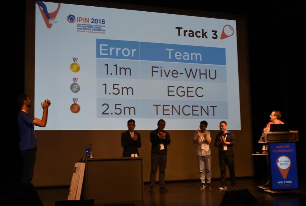
1 Smartphone Positioning and 3D Mapping Indoors Ruizhi Chen Wuhan University Oct. 4, 2018, Delft
2 Adding a Smart LIFE to 3D People spend 80% of their time indoors When People Communicates to a Robot, We Need Locations Locating Actors Living in 3D Space will Facilitate Smart Interactions and Enable Intelligent Applications

3 Mixed Reality Games in 3D Spaces Interaction between a virtual object and a human


4 Autonomous Driving for Underground Parking B06 56 m Precisely Locate the Vehicles in a 3D Space

5 Precision Marketing Interaction between human and goods
6 Contents Contents 1 Introduction 2 3 Current Smartphone Positioning Technologies Precise Smartphone Positioning Based on Built-in Sensors and RF Radios 4 Indoor Mapping
7 Contents Contents 1 Introduction 2 3 Current Smartphone Positioning Technologies Precise Smartphone Positioning Based on Built-in Sensors and RF Radios 4 Indoor Mapping

8 Your Phone Knows Where You Are Where am I?
9 The Market Size of LBS and RTLS The Location-Based Services (LBS) and Real-Time Location Systems (RTLS) market size was valued at USD billion in 2017 and is projected to reach USD billion by 2023, at a Compound Annual Growth Rate (CAGR) of 25.4% during the forecast period. The base year considered for the study is 2017 and the forecast period is from 2018 to MarketsandMarkets Reports/location-based-service-market html


10 Challenges for Indoor Positioning Complex topology Complex radio environment Complex human motion patterns


11 Visual Positioning Service A Google Core Technology


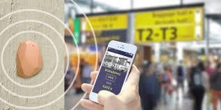
12 ibeacon An Apple Technology Near Far Immediate


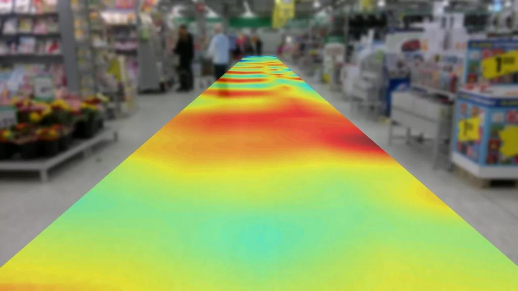

13 Baidu: Magnetic Fingerprinting
14 Contents Contents 1 Introduction 2 3 Current Smartphone Positioning Technologies Precise Smartphone Positioning Based on Built-in Sensors and RF Radios 4 Indoor Mapping


15 Positioning Sensors and RF Radios in Smartphones GNSS Sensors Beidou Galileo GPS GLONASS RF Radios RFID/ NFC BT/BLE WLAN Cellular network & Digital TV
16 Typical Observables GNSS Sensors Beidou Galileo GPS GLONASS RF Radios RFID/ NFC BT/BLE WLAN Cellular network & Digital TV


17 Positioning With WiFi,Sensors and GNSS GNSS GNSS Accelerometer Sensors Beidou Galileo Gyroscope RF signals GPS GLONASS Magnetometer WLAN RF Radios RFID/ NFC BT/BLE WLAN Cellular network & Digital TV
18 Fusing Sensor and RF Measurements Magnetometer Heading GPS Position Speed Gyros Unscented Kalman Filter Location & Heading Accelerometer Position WiFi/i Beacon Indoors/Outdoors Chen, R., Chu, T., Liu, K., Liu, J., & Chen, Y. (2015). Inferring Human Activity in Mobile Devices by Computing Multiple Contexts. Sensors,15(9),
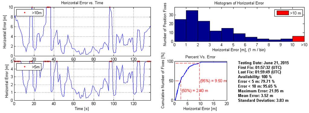

19 Positioning Accuracy 80% Ground Truth: GPS/INS


20 Real-Time : 2-5 meters under typical indoor environment 20 PerfLoc: NIST indoor Positioning Competition
21 Post-Processing Accuracy
22 Contents Contents 1 Introduction 2 3 Current Smartphone Positioning Technologies Precise Smartphone Positioning Based on Built-in Sensors and RF Radios 4 Indoor Mapping
23 Positioning with New Sensors GNSS Light sensor Sensors 北斗 Galileo Camera GPS GLONASS Acoustic sensor RF signals BT/BLE RFID/ NFC BT/BLE WLAN Cellular network & Digital TV

24 Positioning Based on Acoustic Signal


25 Acoustic Ranging Positioning Using the Mic and Speakers of the Smartphone Working spectrum ranges from 16-21KHz Not hearable by human, not interfered by human voices The speed of sound is slow compared to RF signals, therefore, the clock synchronization requirement is not high. Measure TOA Positioning accuracy:decimeters Effective Range:5-20m Speaker Sync. Power
26 Positioning Accuracy 0.2 m at 95%


27 Positioning Based on Light Signal

 or closed")


28 Positioning Using Light An light shade is divided into 8 rings,each ring has 48grids, there are 384 sectors in total. Each sectorial grid can be opened (0) or closed (1), by rotating the shade, the light sensor of the smartphone can receive different light patterns in different sectors. A sector is identified by the light patterns. No hardware change is needed from smartphones Positioning accuracy is 5-10cm. Single Station Positioning for Small Indoor Space Light source:850 nm Infrared

29 A fraction of cell correction in longitude direction Correction in Longitude Direction (ring number, cell number) is too coarse grained (e.g., 0.5 m) Need to obtain two offsets: ΔΘ and Δr A fraction of cell period (signal window length) is used to estimate ΔΘ
30 Δr=1 Δr=0.5 Correction in Radial Direction Δr=0 Inner ring, signal window length 0 Signal window length =0 Signal window length =1 Outer ring, signal window length 1 Signal window length varies between 0 and 1 for different Δr Triangle,NOT Trapezoid
31

32 Visual Positioning with Point-Line-2D-3D Objects


.")

33 Human Eyes vs Smartphone Camera 5 Types of smartphones Error Distribution 3 Test Fields 10 Students Positioning Error Human Brain Phone Camera 0.73m 0.31m Dewen Wu, Ruizhi Chen *, Liang Chen (2017). Visual Positioning Indoors: Human Eyes vs Smartphone Cameras. Sensors 2017, 17, 2645; doi: /s


34 Indoor Visual Positioning aided by CNN-based Image Retrieval Image Retrieval Pose Estimation Chen, Y.; Chen, R.; Liu, M.; Xiao, A.; Wu, D.; Zhao, S. Indoor Visual Positioning Aided by CNN-Based Image Retrieval: Training- Free, 3D Modeling-Free. Sensors 2018, 18, 2692.


35 CNN-Features Employ CNN model to extract features Rank images from database by feature similarity Convolution layers visualization Image feature vectors visualization
36 Positioning Errors Comparison based on the ICL-NUIM dataset Method Living Room Office Room 1495 Samples 1533 Samples PoseNet 0.60m, m, D PoseNet 0.58m, m, 2.81 CNN+LSTM 0.54m, m, 2.66 ours 0.36m, m, 2.47 Better position accuracy, Comparable orientation accuracy; Much fewer images in database construction period (Training images vs. Reference images); 3D-Modeling Free; Training Free; A set of images with high-precision pose is the key.
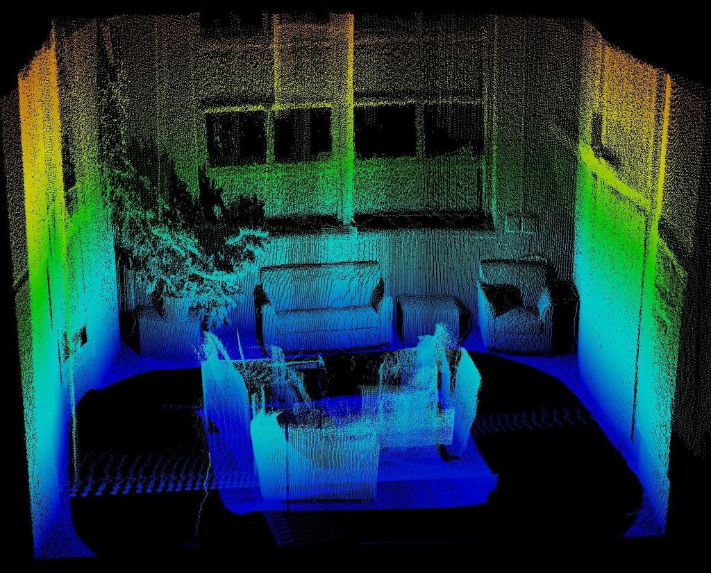

37 Visual Positioning With Depth Camera

38 Positioning Based on RF Signal

39 Nokia BLE Antenna Array


 0.1 Sec.")

40 Positioning With an BT Antenna Array A pseudolite-based approach Broadcast BS positions in WGS-84 TTFF (Time To First Fixed) 0.1 Sec. Low-cost, easy for installation Positioning update rate 1-10Hz Positioning accuracy: 1-2m


41 Wi-Fi Round Time Trip Ranging Wi-Fi AP Based on mc
42 Ranging Error (m) 测距精度 Wi-Fi RTT Ranging Accuracy Ranging Accuracy Measuring Distance (m)

43
44 Contents Contents 1 Introduction 2 3 Current Smartphone Positioning Technologies Precise Smartphone Positioning Based on Built-in Sensors and RF Radios 4 Indoor Mapping

45 Indoor Mapping Approaches Scanned FloorPlan CAD/BIM Indoor Maping Crowded Sources SLAM


46 An Example of Indoor Map Google: Here Map: Baidu: in China Lack of international standard

47 Indoor Mapping Demo

48 3D Modelling Based on Depth Camera


49 A Mobile SLAM Solution FC RGB-D SLAM PhD Thesis: PRECISE RECONSTRUCTION OF INDOOR ENVIRONMENTS USING RGB-DEPTH SENSORS By WALID ABDALLAH ABOUMANDOUR DARWISH Supervisor: Wu Chen Department of Land Surveying and Geo-Informatics Hong Kong Polytechnic University

50 Hong Kong Central Metro Station

51
52 Conclusions There are lots of positioning technologies for indoor, however, there is no such an indoor positioning technology that works like GNSS for outdoor. Using the built-in sensors and RF radios, smartphone positioning can achieve an accuracy of about 2-5meters in real time and about 1 meter by post processing. High precise indoor positioning technologies are capable to deliver centimeter level accuracy, but effective coverage of a single base station is limited. The new Wi-Fi ranging technology will resolve this problem partly. Integration of multiple positioning sources is probably the best option for complex indoor environments. Mobile devices with depth camera are capable of deliver 3D indoor models.
53 Thank You!
Introduction to Mobile Sensing Technology
 Introduction to Mobile Sensing Technology Kleomenis Katevas k.katevas@qmul.ac.uk https://minoskt.github.io Image by CRCA / CNRS / University of Toulouse In this talk What is Mobile Sensing? Sensor data,
Ubiquitous Positioning: A Pipe Dream or Reality?
 Ubiquitous Positioning: A Pipe Dream or Reality? Professor Terry Moore The University of What is Ubiquitous Positioning? Multi-, low-cost and robust positioning Based on single or multiple users Different
Indoor navigation with smartphones
 Indoor navigation with smartphones REinEU2016 Conference September 22 2016 PAVEL DAVIDSON Outline Indoor navigation system for smartphone: goals and requirements WiFi based positioning Application of BLE
Agenda Motivation Systems and Sensors Algorithms Implementation Conclusion & Outlook
 Overview of Current Indoor Navigation Techniques and Implementation Studies FIG ww 2011 - Marrakech and Christian Lukianto HafenCity University Hamburg 21 May 2011 1 Agenda Motivation Systems and Sensors
Hardware-free Indoor Navigation for Smartphones
 Hardware-free Indoor Navigation for Smartphones 1 Navigation product line 1996-2015 1996 1998 RTK OTF solution with accuracy 1 cm 8-channel software GPS receiver 2004 2007 Program prototype of Super-sensitive
MOBILE COMPUTING 1/29/18. Cellular Positioning: Cell ID. Cellular Positioning - Cell ID with TA. CSE 40814/60814 Spring 2018
 MOBILE COMPUTING CSE 40814/60814 Spring 2018 Cellular Positioning: Cell ID Open-source database of cell IDs: opencellid.org Cellular Positioning - Cell ID with TA TA: Timing Advance (time a signal takes
High Precision Urban and Indoor Positioning for Public Safety
 High Precision Urban and Indoor Positioning for Public Safety NextNav LLC September 6, 2012 2012 NextNav LLC Mobile Wireless Location: A Brief Background Mass-market wireless geolocation for wireless devices
Technology Challenges and Opportunities in Indoor Location. Doug Rowitch, Qualcomm, San Diego
 PAGE 1 qctconnect.com Technology Challenges and Opportunities in Indoor Location Doug Rowitch, Qualcomm, San Diego 2 nd Invitational Workshop on Opportunistic RF Localization for Future Directions, Technologies,
Mobile Security Fall 2015
 Mobile Security Fall 2015 Patrick Tague #8: Location Services 1 Class #8 Location services for mobile phones Cellular localization WiFi localization GPS / GNSS 2 Mobile Location Mobile location has become
Integrated Positioning The Challenges New technology More GNSS satellites New applications Seamless indoor-outdoor More GNSS signals personal navigati
 Integrated Indoor Positioning and Navigation Professor Terry Moore Professor of Satellite Navigation Nottingham Geospatial Institute The University of Nottingham Integrated Positioning The Challenges New
Testing of GNSS Dual-Frequency with Smartphones
 Testing of GNSS Dual-Frequency with Smartphones Towards better location performance in mass market applications P. Crosta, G. Galluzzo, R. Orus, R. Lucas, ESA J. Redelkiewicz, GSA ESA UNCLASSIFIED - For
A 3D Ubiquitous Multi-Platform Localization and Tracking System for Smartphones. Seyyed Mahmood Jafari Sadeghi
 A 3D Ubiquitous Multi-Platform Localization and Tracking System for Smartphones by Seyyed Mahmood Jafari Sadeghi A thesis submitted in conformity with the requirements for the degree of Doctor of Philosophy
Robust Positioning in Indoor Environments
 Presented at the FIG Congress 2018, May 6-11, 2018 in Istanbul, Turkey Robust Positioning in Indoor Environments Professor Allison Kealy RMIT University, Australia Professor Guenther Retscher Vienna University
LOCALIZATION WITH GPS UNAVAILABLE
 LOCALIZATION WITH GPS UNAVAILABLE ARES SWIEE MEETING - ROME, SEPT. 26 2014 TOR VERGATA UNIVERSITY Summary Introduction Technology State of art Application Scenarios vs. Technology Advanced Research in
Real Time Indoor Tracking System using Smartphones and Wi-Fi Technology
 International Journal for Modern Trends in Science and Technology Volume: 03, Issue No: 08, August 2017 ISSN: 2455-3778 http://www.ijmtst.com Real Time Indoor Tracking System using Smartphones and Wi-Fi
GPS-Aided INS Datasheet Rev. 2.6
 GPS-Aided INS 1 GPS-Aided INS The Inertial Labs Single and Dual Antenna GPS-Aided Inertial Navigation System INS is new generation of fully-integrated, combined GPS, GLONASS, GALILEO and BEIDOU navigation
Indoor Location System with Wi-Fi and Alternative Cellular Network Signal
 , pp. 59-70 http://dx.doi.org/10.14257/ijmue.2015.10.3.06 Indoor Location System with Wi-Fi and Alternative Cellular Network Signal Md Arafin Mahamud 1 and Mahfuzulhoq Chowdhury 1 1 Dept. of Computer Science
Terrestrial Laser Scanning. 3D Laser Scanner with Real-Time Registration & Processing. Preliminary Data Sheet
 VZ 4 3D Laser Scanner with Real-Time Registration & Processing RIEGL VZ-4i new, innovative processing architecture for data acquisition and simultaneous geo-referencing, filtering and analysis in real-time
ASR-2300 Multichannel SDR Module for PNT and Mobile communications. Dr. Michael B. Mathews Loctronix, Corporation
 ASR-2300 Multichannel SDR Module for PNT and Mobile communications GNU Radio Conference 2013 October 1, 2013 Boston, Massachusetts Dr. Michael B. Mathews Loctronix, Corporation Loctronix Corporation 2008,
Positioning Architectures in Wireless Networks
 Lectures 1 and 2 SC5-c (Four Lectures) Positioning Architectures in Wireless Networks by Professor A. Manikas Chair in Communications & Array Processing References: [1] S. Guolin, C. Jie, G. Wei, and K.
Indoor Navigation and the. Conferest Demo App
 Indoor Navigation and the Presented at the FIG Working Week 2017, May 29 - June 2, 2017 in Helsinki, Finland Conferest Demo App Dept. of Navigation and Positioning Finnish Geospatial Research Institute
Cooperative localization (part I) Jouni Rantakokko
 Jouni Rantakokko") Cooperative localization (part I) Jouni Rantakokko Cooperative applications / approaches Wireless sensor networks Robotics Pedestrian localization First responders Localization sensors - Small, low-cost
Cooperative localization (part I) Jouni Rantakokko Cooperative applications / approaches Wireless sensor networks Robotics Pedestrian localization First responders Localization sensors - Small, low-cost
GPS-Aided INS Datasheet Rev. 2.3
 GPS-Aided INS 1 The Inertial Labs Single and Dual Antenna GPS-Aided Inertial Navigation System INS is new generation of fully-integrated, combined L1 & L2 GPS, GLONASS, GALILEO and BEIDOU navigation and
Indoor Positioning System using Magnetic Positioning and BLE beacons
 Indoor Positioning System using Magnetic Positioning and BLE beacons Prof.Manoj.V. Bramhe 1, Jeetendra Gan 2, Nayan Ghodpage 3, Ankit Nawale 4, Gurendra Bahe 5 1Associate Professor & HOD, Dept of Information
Indoor Positioning and Navigation System Market Research Report- Forecast 2023
 Report Information More information from: https://www.marketresearchfuture.com/reports/1775 Indoor Positioning and Navigation System Market Research Report- Forecast 2023 Report / Search Code: MRFR/SEM/1243-CRR
Inertial Sensors. Ellipse Series MINIATURE HIGH PERFORMANCE. Navigation, Motion & Heave Sensing IMU AHRS MRU INS VG
 Ellipse Series MINIATURE HIGH PERFORMANCE Inertial Sensors IMU AHRS MRU INS VG ITAR Free 0.2 RMS Navigation, Motion & Heave Sensing ELLIPSE SERIES sets up new standard for miniature and cost-effective
Sponsored by. Nisarg Kothari Carnegie Mellon University April 26, 2011
 Sponsored by Nisarg Kothari Carnegie Mellon University April 26, 2011 Motivation Why indoor localization? Navigating malls, airports, office buildings Museum tours, context aware apps Augmented reality
Cooperative navigation: outline
 Positioning and Navigation in GPS-challenged Environments: Cooperative Navigation Concept Dorota A Grejner-Brzezinska, Charles K Toth, Jong-Ki Lee and Xiankun Wang Satellite Positioning and Inertial Navigation
Utility of Sensor Fusion of GPS and Motion Sensor in Android Devices In GPS- Deprived Environment
 Utility of Sensor Fusion of GPS and Motion Sensor in Android Devices In GPS- Deprived Environment Amrit Karmacharya1 1 Land Management Training Center Bakhundol, Dhulikhel, Kavre, Nepal Tel:- +977-9841285489
COMPARISON BETWEEN BROADCAST AND PRECISE ORBITS: GPS GLONASS GALILEO AND BEIDOU. A. Caporali and L. Nicolini University of Padova, Italy
 COMPARISON BETWEEN BROADCAST AND PRECISE ORBITS: GPS GLONASS GALILEO AND BEIDOU A. Caporali and L. Nicolini University of Padova, Italy Summary Previous works Input data and method used Comparison between
IoT Wi-Fi- based Indoor Positioning System Using Smartphones
 IoT Wi-Fi- based Indoor Positioning System Using Smartphones Author: Suyash Gupta Abstract The demand for Indoor Location Based Services (LBS) is increasing over the past years as smartphone market expands.
Cooperative navigation (part II)
") Cooperative navigation (part II) An example using foot-mounted INS and UWB-transceivers Jouni Rantakokko Aim Increased accuracy during long-term operations in GNSS-challenged environments for - First responders
Cooperative navigation (part II) An example using foot-mounted INS and UWB-transceivers Jouni Rantakokko Aim Increased accuracy during long-term operations in GNSS-challenged environments for - First responders
Precise Positioning with Smartphones running Android 7 or later
 Precise Positioning with Smartphones running Android 7 or later * René Warnant, * Cécile Deprez, + Quentin Warnant * University of Liege Geodesy and GNSS + Augmenteo, Plaine Image, Lille (France) Belgian
GPS-Aided INS Datasheet Rev. 2.7
 1 The Inertial Labs Single and Dual Antenna GPS-Aided Inertial Navigation System INS is new generation of fully-integrated, combined GPS, GLONASS, GALILEO, QZSS and BEIDOU navigation and highperformance
Indoor Localization and Tracking using Wi-Fi Access Points
 Indoor Localization and Tracking using Wi-Fi Access Points Dubal Omkar #1,Prof. S. S. Koul *2. Department of Information Technology,Smt. Kashibai Navale college of Eng. Pune-41, India. Abstract Location
RY836AI. High Performance GPS & Glonass / GPS & BeiDou Parallel mode antenna module with Compass, Gyroscope, Accelerometer, Pressure Sensor.
 27-OCT-2017 56312E31 High Performance GPS & Glonass / GPS & BeiDou Parallel mode antenna module with Compass, Gyroscope, Accelerometer, Pressure Sensor Datasheet PRODUCT DESCRIPTION The REYAX GNSS receiver
Inertial Sensors. Ellipse 2 Series MINIATURE HIGH PERFORMANCE. Navigation, Motion & Heave Sensing IMU AHRS MRU INS VG
 Ellipse 2 Series MINIATURE HIGH PERFORMANCE Inertial Sensors IMU AHRS MRU INS VG ITAR Free 0.1 RMS Navigation, Motion & Heave Sensing ELLIPSE SERIES sets up new standard for miniature and cost-effective
Development of Ultimate Seamless Positioning System for Global Cellular Phone Platform based on QZSS IMES
 Development of Ultimate Seamless Positioning System for Global Cellular Phone Platform based on QZSS IMES Dinesh Manandhar, Kazuki Okano, Makoto Ishii, Masahiro Asako, Hideyuki Torimoto GNSS Technologies
Multipath Mitigation Algorithm Results using TOA Beacons for Integrated Indoor Navigation
 Multipath Mitigation Algorithm Results using TOA Beacons for Integrated Indoor Navigation ION GNSS 28 September 16, 28 Session: FOUO - Military GPS & GPS/INS Integration 2 Alison Brown and Ben Mathews,
Webinar. 9 things you should know about centimeter-level GNSS accuracy
 Webinar 9 things you should know about centimeter-level GNSS accuracy Webinar agenda 9 things you should know about centimeter-level GNSS accuracy 1. High precision GNSS challenges 2. u-blox F9 technology
Inertial Sensors. Ellipse Series MINIATURE HIGH PERFORMANCE. Navigation, Motion & Heave Sensing IMU AHRS MRU INS VG
 Ellipse Series MINIATURE HIGH PERFORMANCE Inertial Sensors IMU AHRS MRU INS VG ITAR Free 0.1 RMS Navigation, Motion & Heave Sensing ELLIPSE SERIES sets up new standard for miniature and cost-effective
Wi-Fi Localization and its
 Stanford's 2010 PNT Challenges and Opportunities Symposium Wi-Fi Localization and its Emerging Applications Kaveh Pahlavan, CWINS/WPI & Skyhook Wireless November 9, 2010 LBS Apps from 10s to 10s of Thousands
NMI's Role and Expertise in Synchronization Applications
 NMI's Role and Expertise in Synchronization Applications Wen-Hung Tseng National Time and Frequency standard Lab, Telecommunication Laboratories, Chunghwa Telecom Co., Ltd., Taiwan APMP 2014 Time-transfer
Indoor localization using NFC and mobile sensor data corrected using neural net
 Proceedings of the 9 th International Conference on Applied Informatics Eger, Hungary, January 29 February 1, 2014. Vol. 2. pp. 163 169 doi: 10.14794/ICAI.9.2014.2.163 Indoor localization using NFC and
INDOOR LOCATION SENSING AMBIENT MAGNETIC FIELD. Jaewoo Chung
 INDOOR LOCATION SENSING AMBIENT MAGNETIC FIELD Jaewoo Chung Positioning System INTRODUCTION Indoor positioning system using magnetic field as location reference Magnetic field inside building? Heading
GPS-Aided INS Datasheet Rev. 3.0
 1 GPS-Aided INS The Inertial Labs Single and Dual Antenna GPS-Aided Inertial Navigation System INS is new generation of fully-integrated, combined GPS, GLONASS, GALILEO, QZSS, BEIDOU and L-Band navigation
AGENDA. NEI Overview. Mobile platforms with the new R1 / R2 GNSS receiver. High Accuracy Cloud Based Data Collection. Geo 7X Higher Accuracy Option
 AGENDA NEI Overview Mobile platforms with the new R1 / R2 GNSS receiver High Accuracy Cloud Based Data Collection Geo 7X Higher Accuracy Option Selecting - the Right Tool for the Right Job Field to Finish.
Smart Space - An Indoor Positioning Framework
 Smart Space - An Indoor Positioning Framework Droidcon 09 Berlin, 4.11.2009 Stephan Linzner, Daniel Kersting, Dr. Christian Hoene Universität Tübingen Research Group on Interactive Communication Systems
SMART RFID FOR LOCATION TRACKING
 SMART RFID FOR LOCATION TRACKING By: Rashid Rashidzadeh Electrical and Computer Engineering University of Windsor 1 Radio Frequency Identification (RFID) RFID is evolving as a major technology enabler
IOT GEOLOCATION NEW TECHNICAL AND ECONOMICAL OPPORTUNITIES
 IOT GEOLOCATION NEW TECHNICAL AND ECONOMICAL OPPORTUNITIES Florian LECLERE f.leclere@kerlink.fr EOT Conference Herning 2017 November 1st, 2017 AGENDA 1 NEW IOT PLATFORM LoRa LPWAN Platform Geolocation
Surveying in the Year 2020
 Surveying in the Year 2020 Johannes Schwarz Leica Geosystems My first toys 2 1 3 Questions Why is a company like Leica Geosystems constantly developing new surveying products and instruments? What surveying
Public or Private (2)
") // Public or Private () CCST90 Mar, 0 Dr. Hayden Kwok-Hay So Department of Electrical and Electronic Engineering The Making of Google Street View Google Street View Systematically capture photos of the
// Public or Private () CCST90 Mar, 0 Dr. Hayden Kwok-Hay So Department of Electrical and Electronic Engineering The Making of Google Street View Google Street View Systematically capture photos of the
ARUBA LOCATION SERVICES
 ARUBA LOCATION SERVICES Powered by Aruba Beacons The flagship product of the product line is Aruba Beacons. When Aruba Beacons are used in conjunction with the Meridian mobile app platform, they enable
GPS and Recent Alternatives for Localisation. Dr. Thierry Peynot Australian Centre for Field Robotics The University of Sydney
 GPS and Recent Alternatives for Localisation Dr. Thierry Peynot Australian Centre for Field Robotics The University of Sydney Global Positioning System (GPS) All-weather and continuous signal system designed
Inertial Sensors. Ellipse 2 Series MINIATURE HIGH PERFORMANCE. Navigation, Motion & Heave Sensing IMU AHRS MRU INS VG
 Ellipse 2 Series MINIATURE HIGH PERFORMANCE Inertial Sensors IMU AHRS MRU INS VG ITAR Free 0.1 RMS Navigation, Motion & Heave Sensing ELLIPSE SERIES sets up new standard for miniature and cost-effective
Continuous High Precision Navigation Using MEMS Inertial Sensors Aided RTK GPS for Mobile Mapping Applications
 Continuous High Precision Navigation Using MEMS Inertial Sensors Aided RTK GPS for Mobile Mapping Applications Yong Li 1, Augustine Tsai 2, Peter Mumford 1, Wei-sen Lin 2, I-chou Hong 2 1 School of Surveying
Mobile Cognitive Indoor Assistive Navigation for the Visually Impaired
 1 Mobile Cognitive Indoor Assistive Navigation for the Visually Impaired Bing Li 1, Manjekar Budhai 2, Bowen Xiao 3, Liang Yang 1, Jizhong Xiao 1 1 Department of Electrical Engineering, The City College,
Development of Hong Kong GNSS infrastructure
 Development of Hong Kong GNSS infrastructure Wu Chen Department of Land Surveying and Geoinformatics (LSGI) Hong Kong Polytechnic University Hong Kong 1 Research Areas Research Areas GNSS Positioning and
I E E E 5 G W O R L D F O R U M 5 G I N N O V A T I O N S & C H A L L E N G E S
 I E E E 5 G W O R L D F O R U M 5 G I N N O V A T I O N S & C H A L L E N G E S David Lu Vice President, ECOMP Platform & Systems Development AT&T 2018 AT&T Intellectual Property. All Rights Reserved.
Update on BeiDou Navigation Satellite System
 Update on BeiDou Navigation Satellite System 1 BDS Development 2 Near-term Plans BD-2 System FOC services from December, 2012 (5GEO+5IGSO+4MEO) Two on-orbit backup satellites launched in 2016 (1 IGSO+1
Mobile Positioning in Wireless Mobile Networks
 Mobile Positioning in Wireless Mobile Networks Peter Brída Department of Telecommunications and Multimedia Faculty of Electrical Engineering University of Žilina SLOVAKIA Outline Why Mobile Positioning?
Pedestrian Navigation System Using. Shoe-mounted INS. By Yan Li. A thesis submitted for the degree of Master of Engineering (Research)
") Pedestrian Navigation System Using Shoe-mounted INS By Yan Li A thesis submitted for the degree of Master of Engineering (Research) Faculty of Engineering and Information Technology University of Technology,
Pedestrian Navigation System Using Shoe-mounted INS By Yan Li A thesis submitted for the degree of Master of Engineering (Research) Faculty of Engineering and Information Technology University of Technology,
Near-Field Electromagnetic Ranging (NFER) Indoor Location
 Indoor Location") Near-Field Electromagnetic Ranging (NFER) Indoor Location 21 st Test Instrumentation Workshop Thursday May 11, 2017 Hans G. Schantz h.schantz@q-track.com Q-Track Corporation Sheila Jones sheila.jones@navy.mil
Near-Field Electromagnetic Ranging (NFER) Indoor Location 21 st Test Instrumentation Workshop Thursday May 11, 2017 Hans G. Schantz h.schantz@q-track.com Q-Track Corporation Sheila Jones sheila.jones@navy.mil
GNSS Technologies. GNSS integration with other positioning methods
 GNSS Technologies GNSS integration with other positioning methods 1 29.3.2017 Content Location system alternatives RF types and classifications Locationing using RF signals Cellular positioning DTV-signal
Wi-Fi Fingerprinting through Active Learning using Smartphones
 Wi-Fi Fingerprinting through Active Learning using Smartphones Le T. Nguyen Carnegie Mellon University Moffet Field, CA, USA le.nguyen@sv.cmu.edu Joy Zhang Carnegie Mellon University Moffet Field, CA,
INDOOR LOCATION SENSING USING GEO-MAGNETISM
 INDOOR LOCATION SENSING USING GEO-MAGNETISM Jaewoo Chung 1, Matt Donahoe 1, Chris Schmandt 1, Ig-Jae Kim 1, Pedram Razavai 2, Micaela Wiseman 2 MIT Media Laboratory 20 Ames St. Cambridge, MA 02139 1 {jaewoo,
ADMA. Automotive Dynamic Motion Analyzer with 1000 Hz. ADMA Applications. State of the art: ADMA GPS/Inertial System for vehicle dynamics testing
 ADMA Automotive Dynamic Motion Analyzer with 1000 Hz State of the art: ADMA GPS/Inertial System for vehicle dynamics testing ADMA Applications The strap-down technology ensures that the ADMA is stable
Case sharing of the use of RF Localization Techniques. Dr. Frank Tong LSCM R&D Centre LSCM Summit 2015
 Case sharing of the use of RF Localization Techniques Dr. Frank Tong LSCM R&D Centre LSCM Summit 2015 Outline A. LBS tracking and monitoring 1) Case of anti-wandering-off tracking vest system in elderly
PROTECTING GPS/GNSS-RELIANT MILITARY SYSTEMS
 PROTECTING GPS/GNSS-RELIANT MILITARY SYSTEMS John Fischer VP Advanced R&D Jon Sinden Product Manager, Rugged PNT 6/21/2018 ABOUT OROLIA A world leader in assured positioning, navigation and timing (PNT)
GALILEO AND EGNOS VALUE PROPOSITION FOR E112
 Ref. Ares(2014)1665692-22/05/2014 GALILEO AND EGNOS VALUE PROPOSITION FOR E112 Fiammetta Diani, Justyna REDELKIEWICZ European GNSS Agency (GSA) Brussels, 07/05/2014 Agenda European GNSS Agency at a glance
B L E N e t w o r k A p p l i c a t i o n s f o r S m a r t M o b i l i t y S o l u t i o n s
 B L E N e t w o r k A p p l i c a t i o n s f o r S m a r t M o b i l i t y S o l u t i o n s A t e c h n i c a l r e v i e w i n t h e f r a m e w o r k o f t h e E U s Te t r a m a x P r o g r a m m
NavShoe Pedestrian Inertial Navigation Technology Brief
 NavShoe Pedestrian Inertial Navigation Technology Brief Eric Foxlin Aug. 8, 2006 WPI Workshop on Precision Indoor Personnel Location and Tracking for Emergency Responders The Problem GPS doesn t work indoors
Using Intelligent Mobile Devices for Indoor Wireless Location Tracking, Navigation, and Mobile Augmented Reality
 Using Intelligent Mobile Devices for Indoor Wireless Location Tracking, Navigation, and Mobile Augmented Reality Chi-Chung Alan Lo, Tsung-Ching Lin, You-Chiun Wang, Yu-Chee Tseng, Lee-Chun Ko, and Lun-Chia
 Wireless Technology Wireless devices transmit information via Electromagnetic waves Early wireless devices Radios often called wireless in old WWII movies Broadcast TV TV remote controls Garage door openers
DYNAMIC BLUETOOTH BEACONS FOR PEOPLE WITH DISABILITIES
 DYNAMIC BLUETOOTH BEACONS FOR PEOPLE WITH DISABILITIES A journey from ibeacon to IoT beacons, InfinIT Summit 2017 BLUETOOTH BEACONS Short information sent by radio A few times per second Kind of radio
Fast radio interferometric measurement on low power COTS radio chips A. Bata, A. Bíró, Gy. Kalmár and M. Maróti University of Szeged, Hungary
 Fast radio interferometric measurement on low power COS radio chips A. Bata, A. Bíró, Gy. Kalmár and M. Maróti University of Szeged, Hungary ÁMOP-...A-//KONV-0-007: elemedicine oriented research in the
2017 Technology, Media and Telecommunications Predictions Middle East edition
 2017 Technology, Media and Telecommunications Predictions Middle East edition Foreword Welcome to the 2017 edition of Deloitte s Predictions for the technology, media and telecommunications (TMT) sectors.
Pervasive Indoor Localization and Tracking Based on Fingerprinting. Gary Chan Professor, CSE HKUST
 Pervasive Indoor Localization and Tracking Based on Fingerprinting Gary Chan Professor, CSE HKUST 2 Catchphrase: Location, Location, Location! 3 Outdoor Location-Based Services (LBS) Based on GPS (Global
Seamless Navigation Demonstration Using Japanese Quasi-Zenith Satellite System (QZSS) and IMES
 and IMES") Seamless Navigation Demonstration Using Japanese Quasi-Zenith Satellite System (QZSS) and IMES ICG WG-B Application SG Meeting Munich, Germany March 12, 2012 Satellite Positioning Research and Application
Seamless Navigation Demonstration Using Japanese Quasi-Zenith Satellite System (QZSS) and IMES ICG WG-B Application SG Meeting Munich, Germany March 12, 2012 Satellite Positioning Research and Application
Next Generation Positioning Infrastructure
 Next Generation Positioning Infrastructure The GNSS Network in the 21 st Century Joel VAN CRANENBROECK & Partners Beyond East & West GeoSensing Community 1 INFRASTRUCTURE "The installations that form the
Participants: A.K.A. "Senseless Confusion" Scott McNeese, Cirrus Logic. Facilitator: Ron Kuper, Sonos, Inc.
 Participants: A.K.A. "Senseless Confusion" Larry Przywara, Tensilica, Inc. Michael Pate, Audience Jan-Paul Huijser, NXP Cyril Martin, Analog Devices Scott McNeese, Cirrus Logic Howard Brown, IDT, Inc.
Low Power Gelocation Solution. Stéphane BOUDAUD CTO Abeeway Jonathan DAVID Polytech Student
 Low Power Gelocation Solution Stéphane BOUDAUD CTO Abeeway Jonathan DAVID Polytech Student Disruptive radio technologies is taking off for IoT 2 An estimated 50 billions of connected objects by 2020 [CISCO]
LOCALIZZAZIONE INDOOR
 Sicurezza partecipata in Sanita : l esperienza del Progetto Europeo REFIRE LOCALIZZAZIONE Localizzazione Indoor INDOOR Prof. Federica Pascucci RADIOLABS Università degli Studi Roma Tre With the financial
GS Keynote. by Gard Ueland Chairman of Galileo Services. ENC 2012 April 25 th, 2012 Gdańsk
 GS Keynote by Gard Ueland Chairman of Galileo Services ENC 2012 April 25 th, 2012 Gdańsk - GNSS applications and services - Best Growth Opportunity for Europe 2 Market applications and consumer services
SILS: a Smart Indoors Localization Scheme based on on-the-go cooperative Smartphones networks using onboard Bluetooth, WiFi and GNSS
 SILS: a Smart Localization Scheme based on on-the-go cooperative Smartphones networks using onboard Bluetooth, WiFi and GNSS Ihsan Alshahib Lami, Halgurd S. Maghdid and Torben Kuseler Applied Computing
Indoor Positioning Systems WLAN Positioning
 Praktikum Mobile und Verteilte Systeme Indoor Positioning Systems WLAN Positioning Prof. Dr. Claudia Linnhoff-Popien Florian Dorfmeister, Chadly Marouane, Kevin Wiesner http://www.mobile.ifi.lmu.de Sommersemester
FILA: Fine-grained Indoor Localization
 IEEE 2012 INFOCOM FILA: Fine-grained Indoor Localization Kaishun Wu, Jiang Xiao, Youwen Yi, Min Gao, Lionel M. Ni Hong Kong University of Science and Technology March 29 th, 2012 Outline Introduction Motivation
Understanding GPS: Principles and Applications Second Edition
 Understanding GPS: Principles and Applications Second Edition Elliott Kaplan and Christopher Hegarty ISBN 1-58053-894-0 Approx. 680 pages Navtech Part #1024 This thoroughly updated second edition of an
Foreword by Glen Gibbons About this book Acknowledgments List of abbreviations and acronyms List of definitions
 Table of Foreword by Glen Gibbons About this book Acknowledgments List of abbreviations and acronyms List of definitions page xiii xix xx xxi xxv Part I GNSS: orbits, signals, and methods 1 GNSS ground
Position Location using Radio Fingerprints in Wireless Networks. Prashant Krishnamurthy Graduate Program in Telecom & Networking
 Position Location using Radio Fingerprints in Wireless Networks Prashant Krishnamurthy Graduate Program in Telecom & Networking Agenda Introduction Radio Fingerprints What Industry is Doing Research Conclusions
Bringing Navigation Indoors
 Bringing Navigation Indoors Fabio Belloni Principal Researcher NRC Radio Systems Laboratory Finland Contents Why going indoors? Use cases, opportunities, and challenges Cognitive Positioning Hybrid positioning
The Global Positioning Sytem II 10/19/2017
 The Global Positioning System II Field Experiments 10/19/2017 5-1 Mexico DGPS Field Campaign Cenotes in Tamaulipas, MX, near Aldama 10/19/2017 5-2 Are Cenote Water Levels Related? 10/19/2017 5-3 M. Helper,
GPS Waypoint Application
 GPS Waypoint Application Kris Koiner, Haytham ElMiligi and Fayez Gebali Department of Electrical and Computer Engineering University of Victoria Victoria, BC, Canada Email: {kkoiner, haytham, fayez}@ece.uvic.ca
Indoor Positioning using IMU and Radio Reciever
 1 / 30 Mannesson et al., Indoor Positioning using IMU and Radio Reciever Indoor Positioning using IMU and Radio Reciever Anders Mannesson 1 Muhammad Atif Yaqoob 2 Bo Bernhardsson 1 Fredrik Tufvesson 2
School of Surveying & Spatial Information Systems, UNSW, Sydney, Australia
 Development of an Unmanned Aerial Vehicle Platform Using Multisensor Navigation Technology School of Surveying & Spatial Information Systems, UNSW, Sydney, Australia Gang Sun 1,2, Jiawei Xie 1, Yong Li
Resume of Yuanxin Wu
 Assistant Professor Department of Automatic Control National University of Defense Technology Changsha, Hunan, P. R. China, 410073 Email: yuanx_wu@hotmail.com Now Visiting Post Doctoral Fellow Department
Multipath Mitigation Algorithm Results using TOA Beacons for Integrated Indoor Navigation
 Multipath Mitigation Algorithm Results using TOA Beacons for Integrated Indoor Navigation ION GNSS 28 September 16, 28 Session: FOUO - Military GPS & GPS/INS Integration 2 Alison Brown and Ben Mathews,
Indoor Positioning by the Fusion of Wireless Metrics and Sensors
 Indoor Positioning by the Fusion of Wireless Metrics and Sensors Asst. Prof. Dr. Özgür TAMER Dokuz Eylül University Electrical and Electronics Eng. Dept Indoor Positioning Indoor positioning systems (IPS)
Reading and working through Learn Networking Basics before this document will help you with some of the concepts used in wireless networks.
 Networking Learn Wireless Basics Introduction This document covers the basics of how wireless technology works, and how it is used to create networks. Wireless technology is used in many types of communication.
Galileo. Opportunities and Challenges by Gard Ueland. November 22, 2011, Brussels. Secure World Foundation Conference. Chairman Galileo Services
 Galileo Opportunities and Challenges by Gard Ueland Chairman Galileo Services Secure World Foundation Conference The Brussels Space Policy Round Table - Galileo November 22, 2011, Brussels Galileo Launch