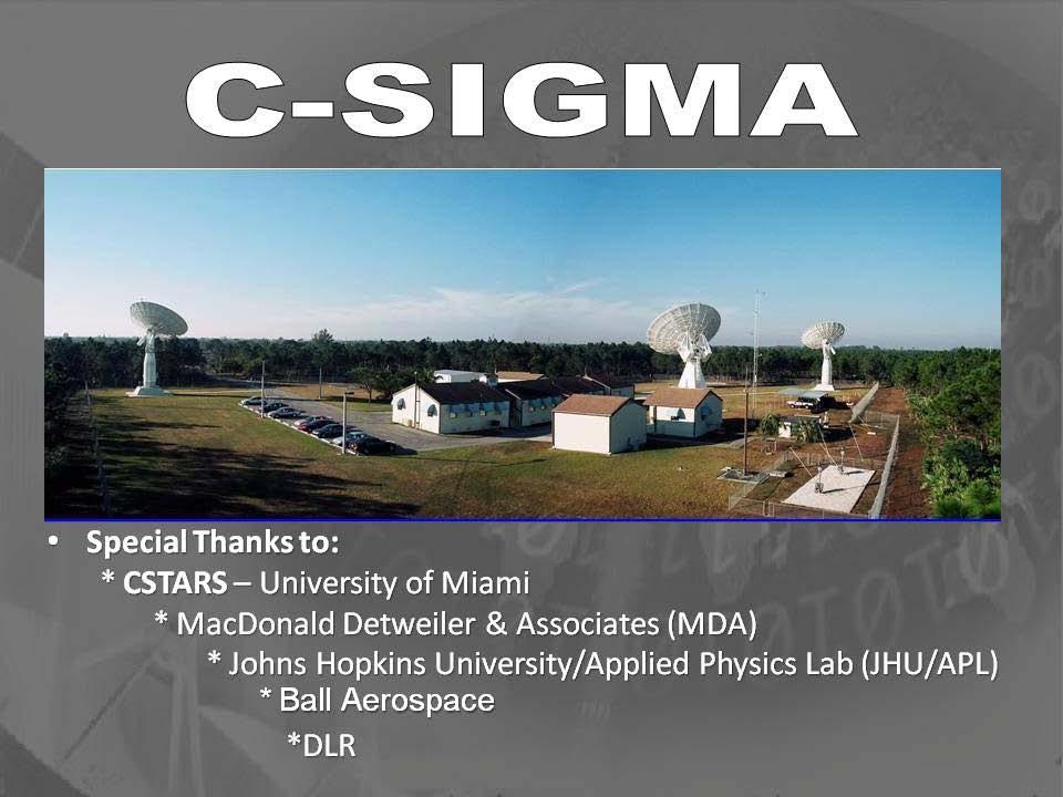
*For International Stewardship of the Maritime Environment and its Resources. Photo
|
|
|
- Cynthia Harris
- 5 years ago
- Views:
Transcription

1 *For International Stewardship of the Maritime Environment and its Resources *For Maritime Safety *For Security Photo
2 # Providing Environmental Monitoring* # Increasing Security* # Enabling Safety Efforts* # Guarding Natural Resources* - Fish - Energy - Mineral *Maritime & Otherwise
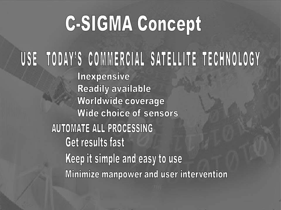
3 - # Not a Program # Not a Canned Solution # Not Even a Proposal # Governance is NOT Discussed # Is an Technology Examination # Is an Awareness Effort A Call to Action!
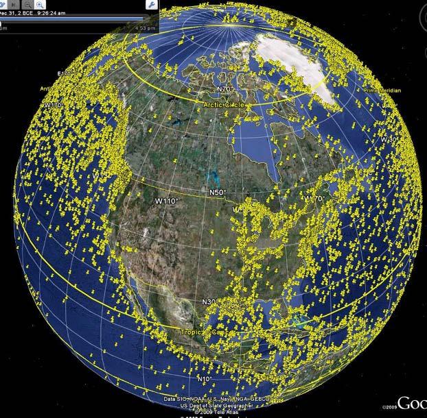
4 LiMES
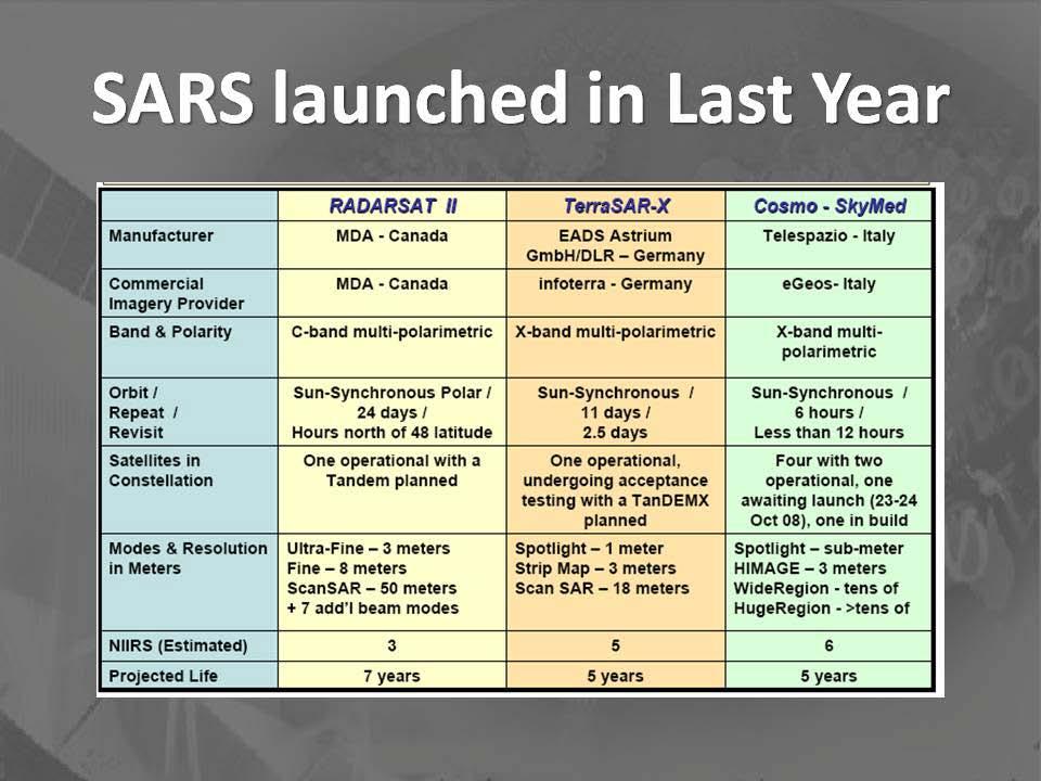
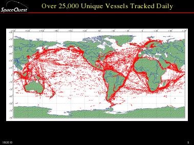
5
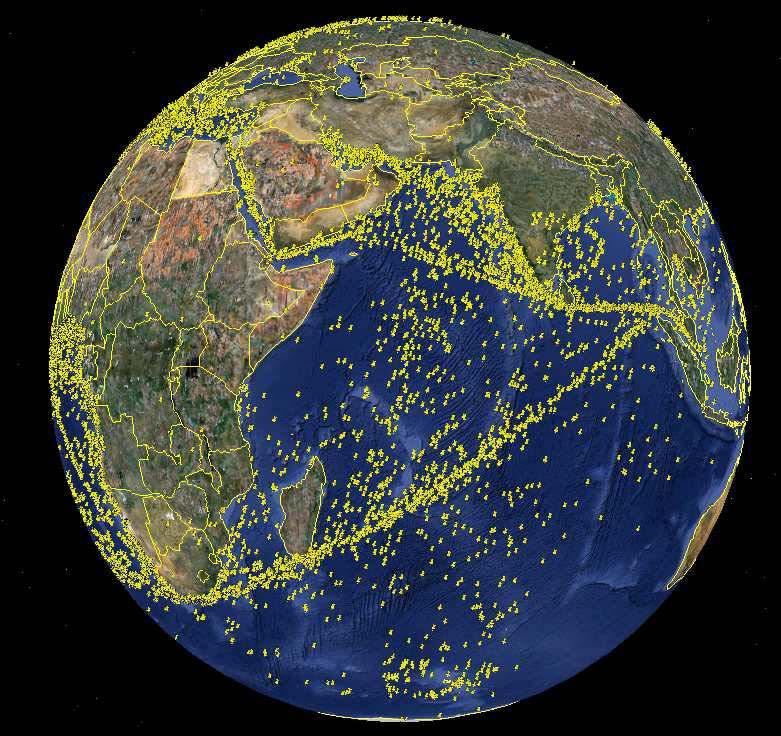
6 LiMES
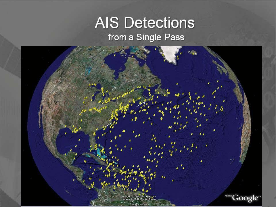
7


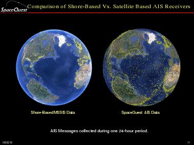
8 *From One Small, Cheap Satellite
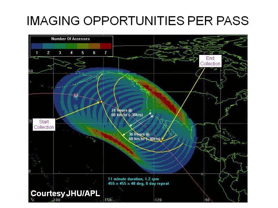
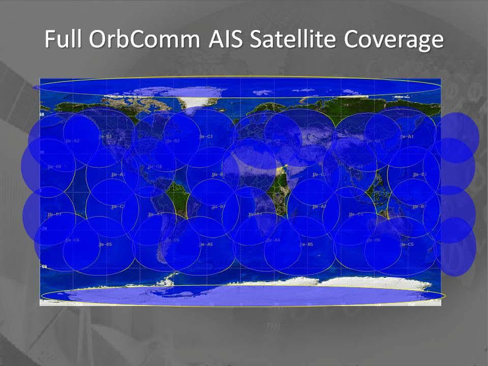
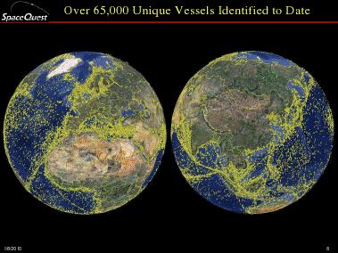
9
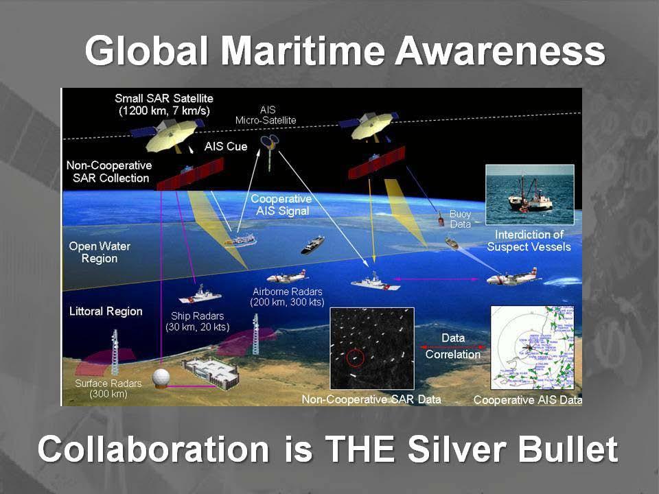
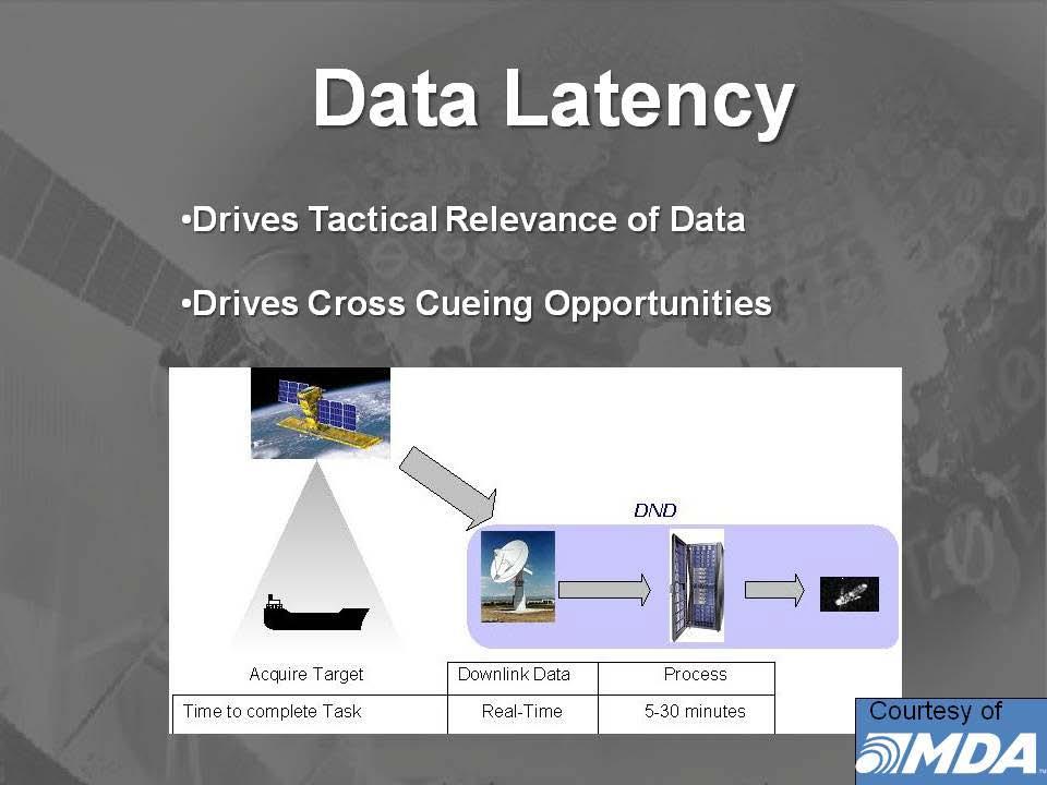
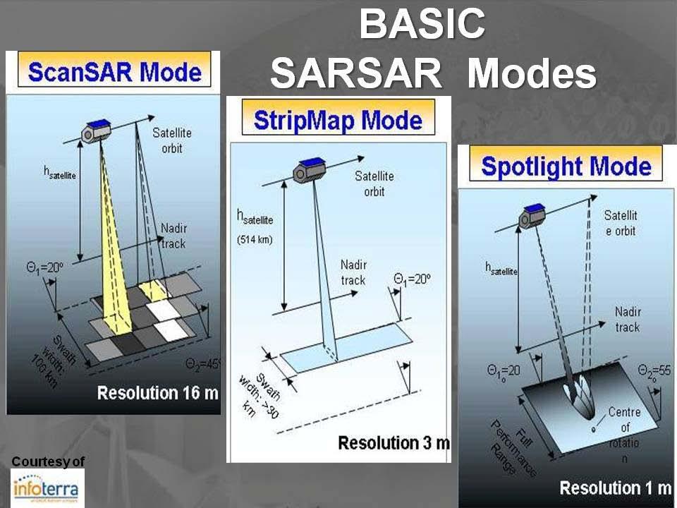
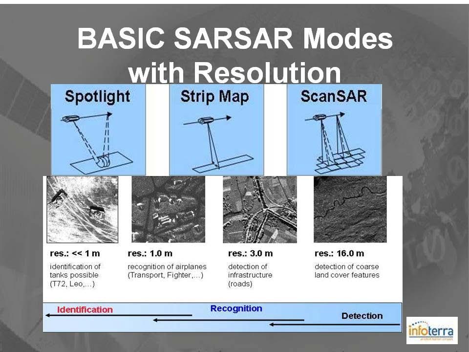
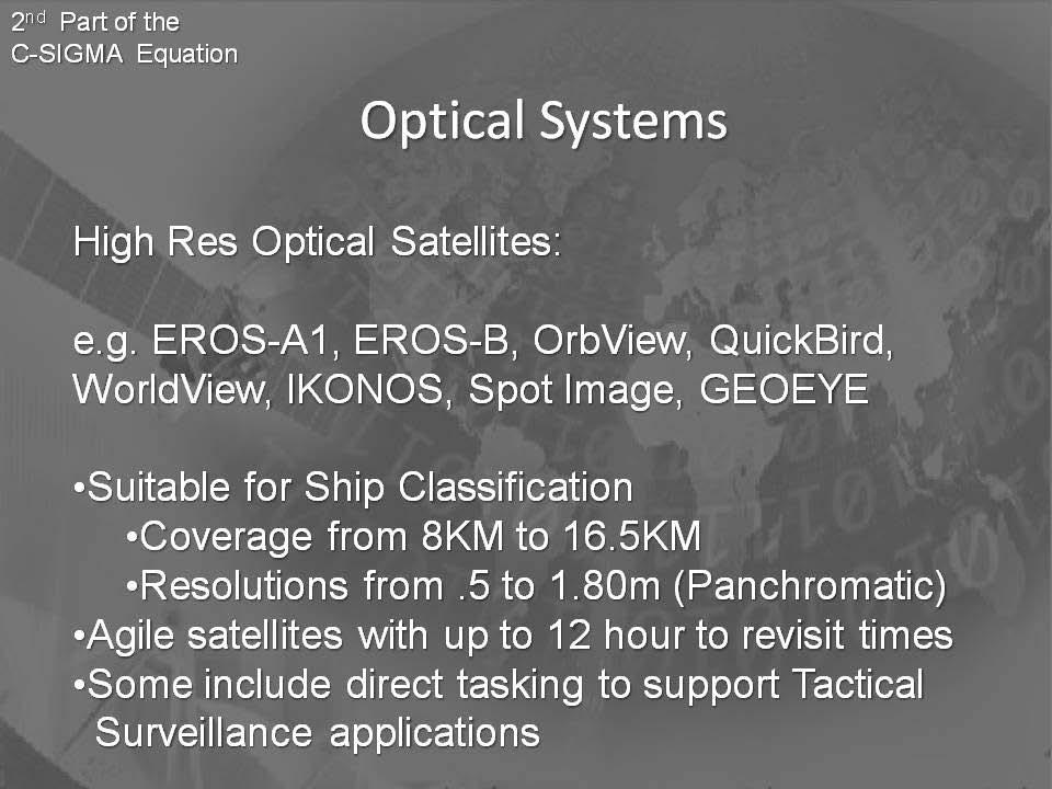
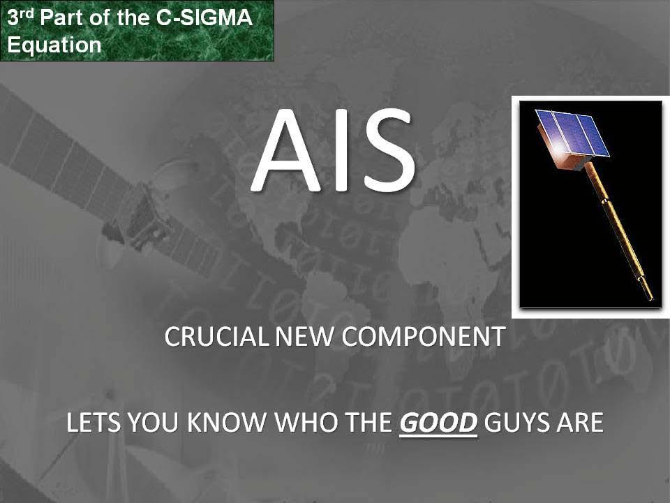
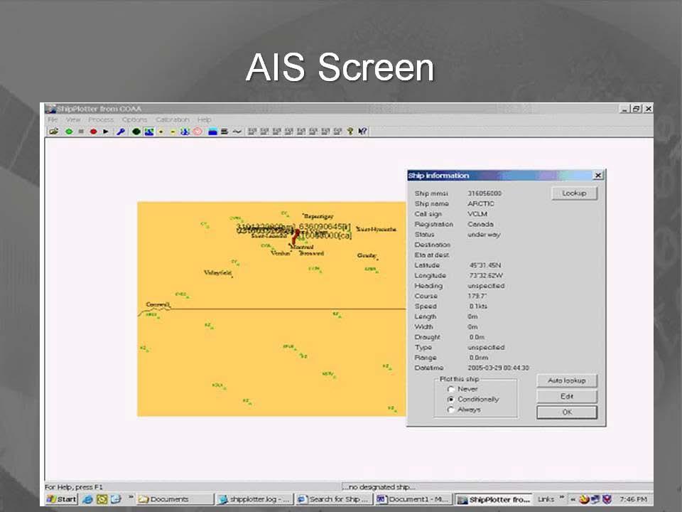
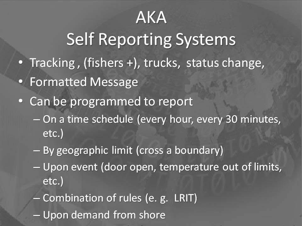
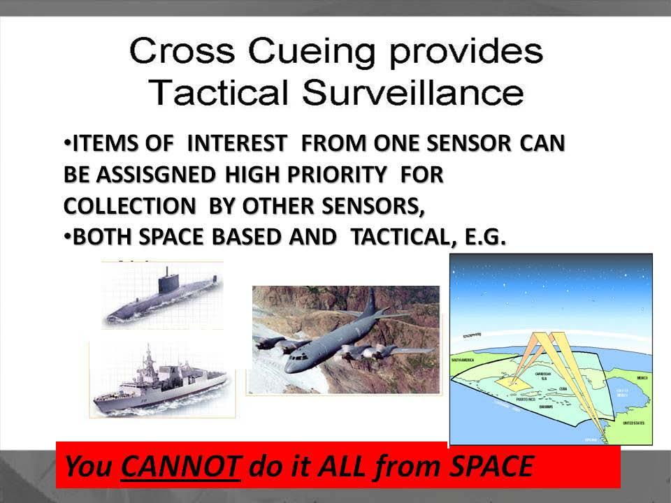
10 Important Factors re Maritime Awareness from Space Integrated into Existing Surveillance Efforts Data Latency Drives Relevance of data & Provides cross-cueing opportunities Applications: Detection: Wide Area Surveillance requires reliable detection Largest Possible Swath & Shortest Revisit Time Classification: AIS & Other Self Reporting Systems (or lack thereof) Identification: High Resolution EO/IR
11
12


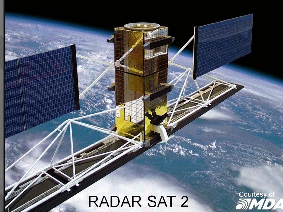
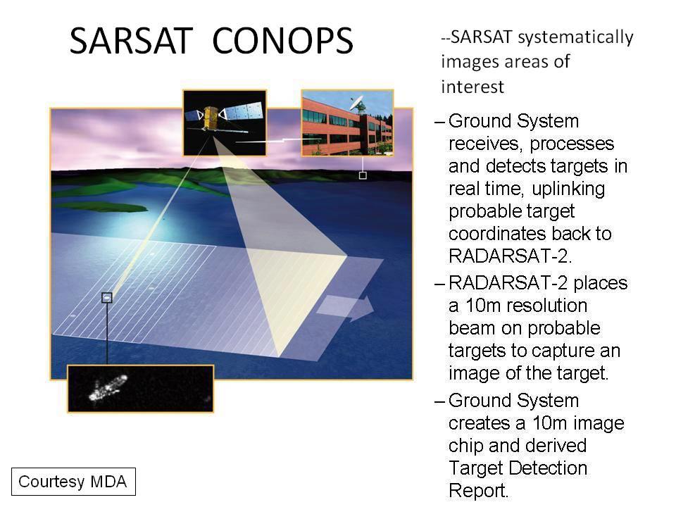
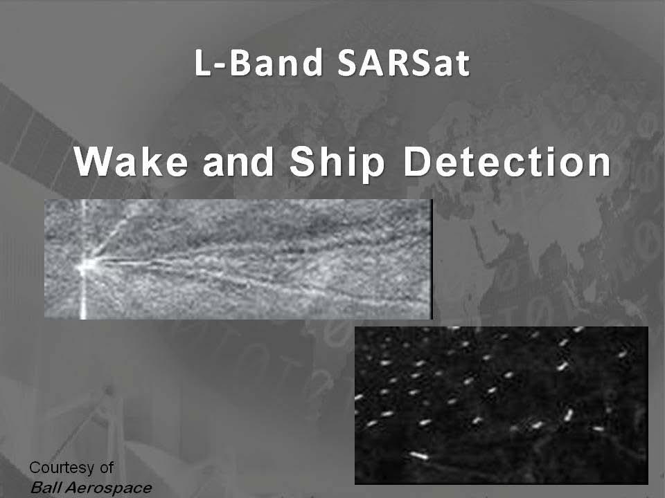
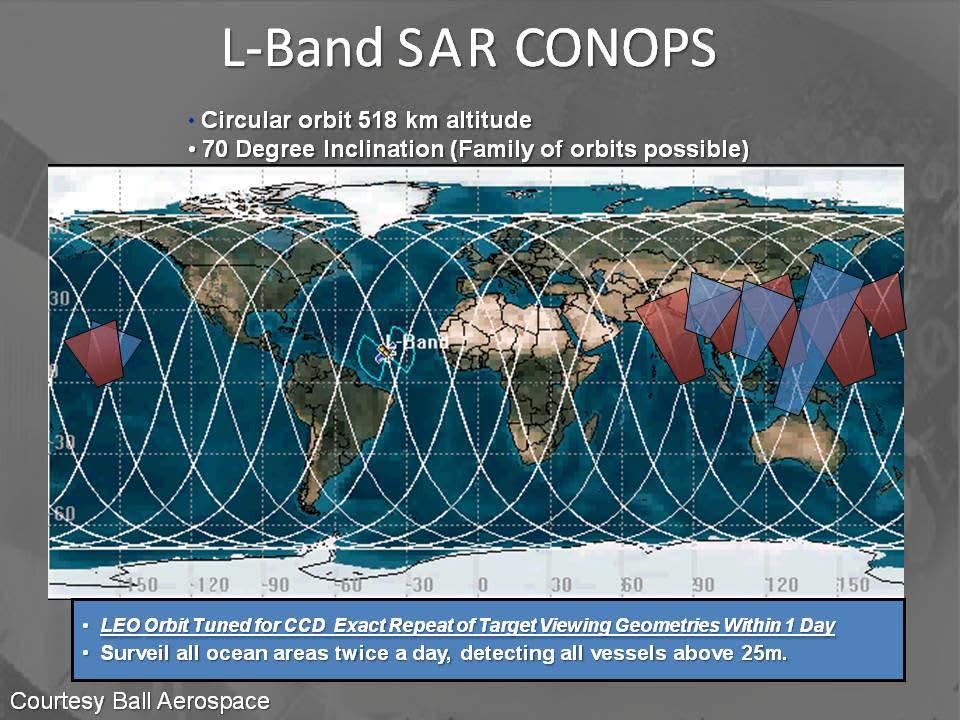
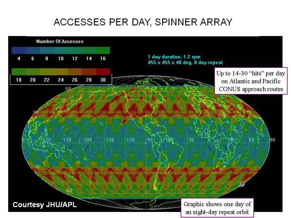
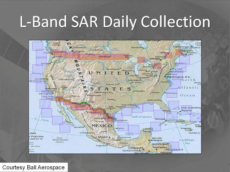
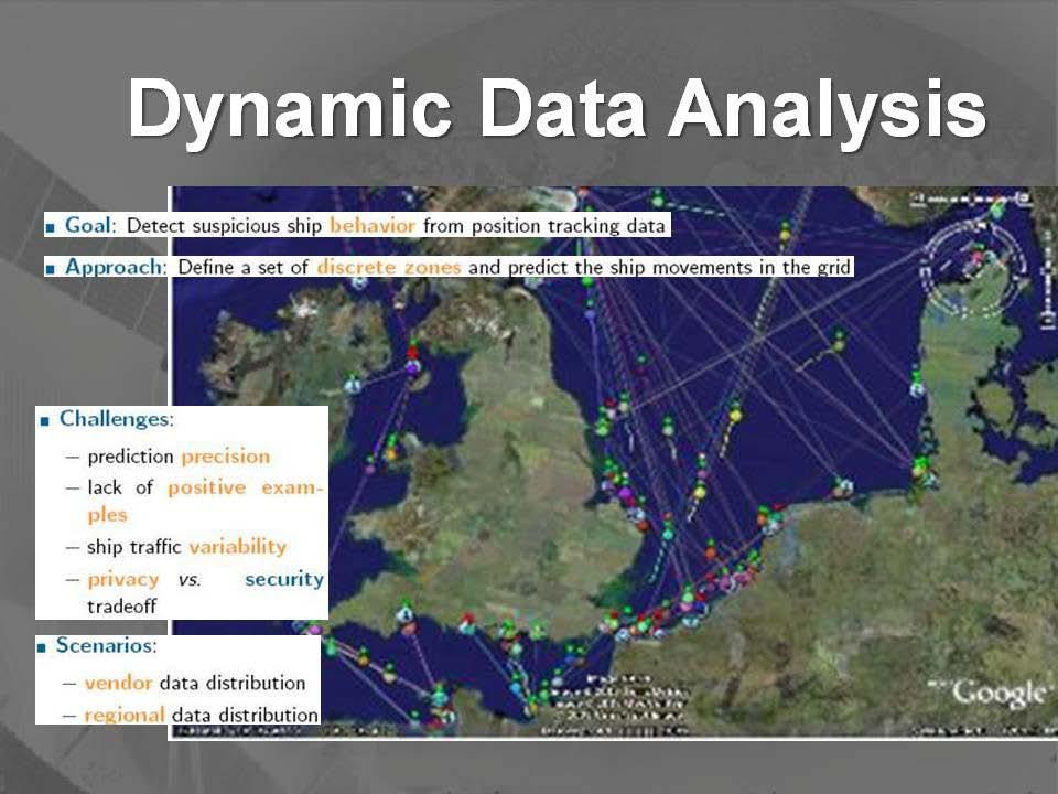
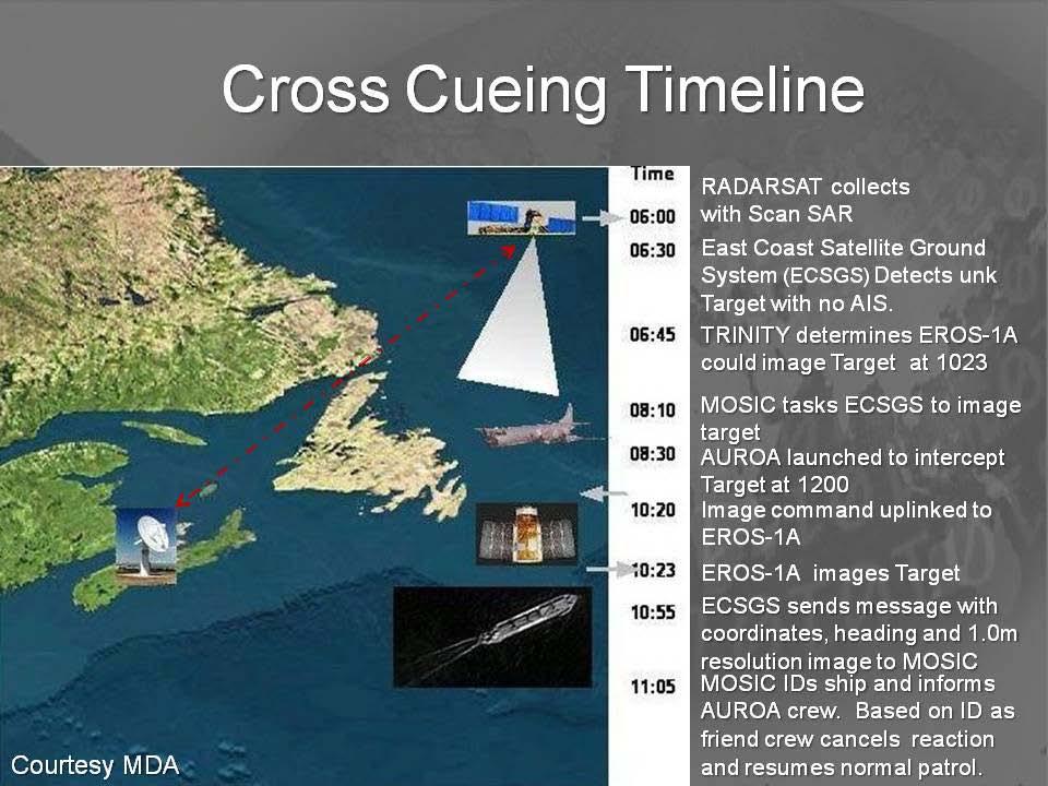
13 1 st Part of C-SIGMA Equation SARSats Space-Based SAR Provides Global Access All-Weather, Day-Night, Dynamically- Tasked, Tactical-Resolution SAR Optimized for large area collections Cues higher-resolution systems - Tipping & Cueing Repeat Orbit Nominal 24 Hour Repeat Optimal CCD over wide area Maritime Domain Awareness Non-SAR Mode for Vessel Detection SAR mode for wake detection Simultaneous SAR Imaging & Tagging TPED using existing ISR Infrastructure Theater tasking/downlink Automated CCD Processing Courtesy of Ball Aerospace Analysis of Change Indicates Potential Activities of Interest
14
15
16
17
18

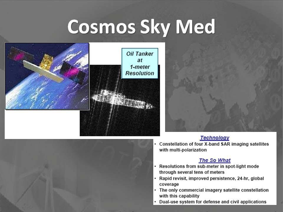
19 Cosmo-SkyMed 1, StripMap-HI imaging mode; 5 m resol. 13 Nov :13 UTC, Descending orbit, Left looking
20
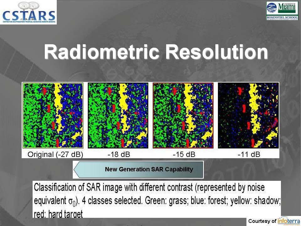
21
22
23
24
25
26
27

28 Frequency & FoPen (Also applies to Wake Detection)
29

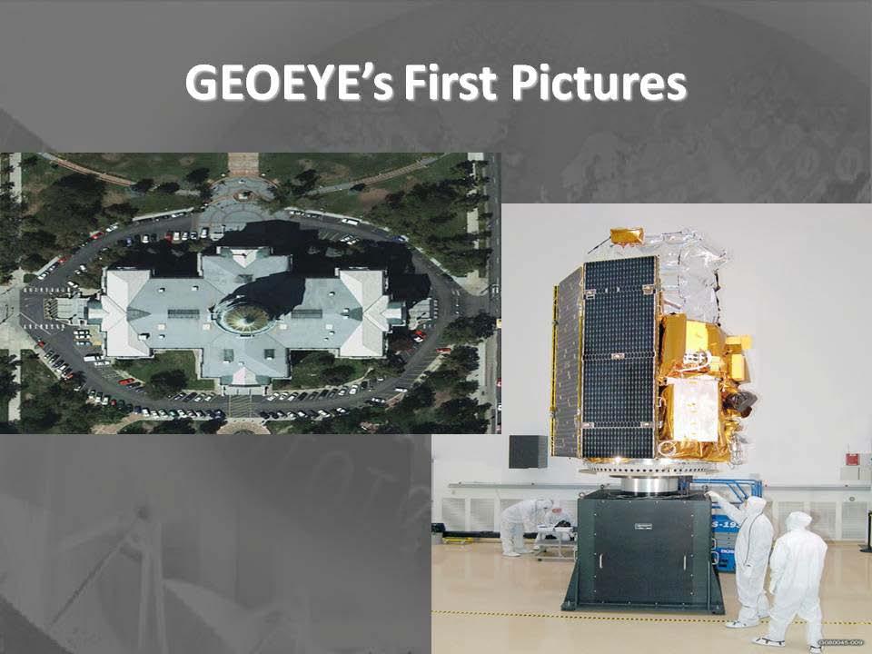
30 This 1-meter resolution image was collected November 20, 2008 by the IKONOS satellite. The image shows the SIRIUS Star, the Saudi-owned crude oil carrier Hijacked by Somali pirates, anchored approximately 5 miles off the Somali coast. (IKONOS is 10 years old.) Photo courtesy of GEO-EYE

31 Freighter off-loading at Casablanca, Morocco Photo courtesy of GEOEYE ½ meter resolution photo of Collected on October 25, 2008 by GEOEYE
32
33
34
35
36
37
38
39
40
41
42

43 VMS
44
45
46
47 Routine Event
48 C-SIGMA Event Timeline A. Commercial Satellites equipped with AIS receivers (S-AIS) continuously Detect s all AIS emitters in area of interest. B. Several Commercial Comm Satellites collect all ship positions reported via LRIT, VMS and private systems.
49 C-SIGMA Event Timeline 1. Radar Satellite images area of interest on routine pass. 2. Central processing facility correlates contacts detected via RadarSat to S-AIS, VMS and LRIT data. Detects three vessels of interest & 3. Alerts appropriate ground stations to task HR imaging satellite(s) to image the areas where the three vessels of interest can next be accessed, based on Traffic Patterns
50 C-SIGMA Event Timeline Routine Event 4. All three resulting images are studied for items of interest, anomalous activity One unit is deemed suspicious 5. MPA is dispatched for a closer look, and Cutter is diverted to intercept, if needed. 6. MPA detects possible illegal activity and maintains track until. 7. Cutter arrives on scene and boards
51
52
53 All of the foregoing begs the question: Initial Steps: 1. Set up International committee? 2.Coordination office at.? ESA? USCG? Canada? US DHS? 3.US coordination led by - USCG? Transportation? DHS? State???? Immediate Next Steps
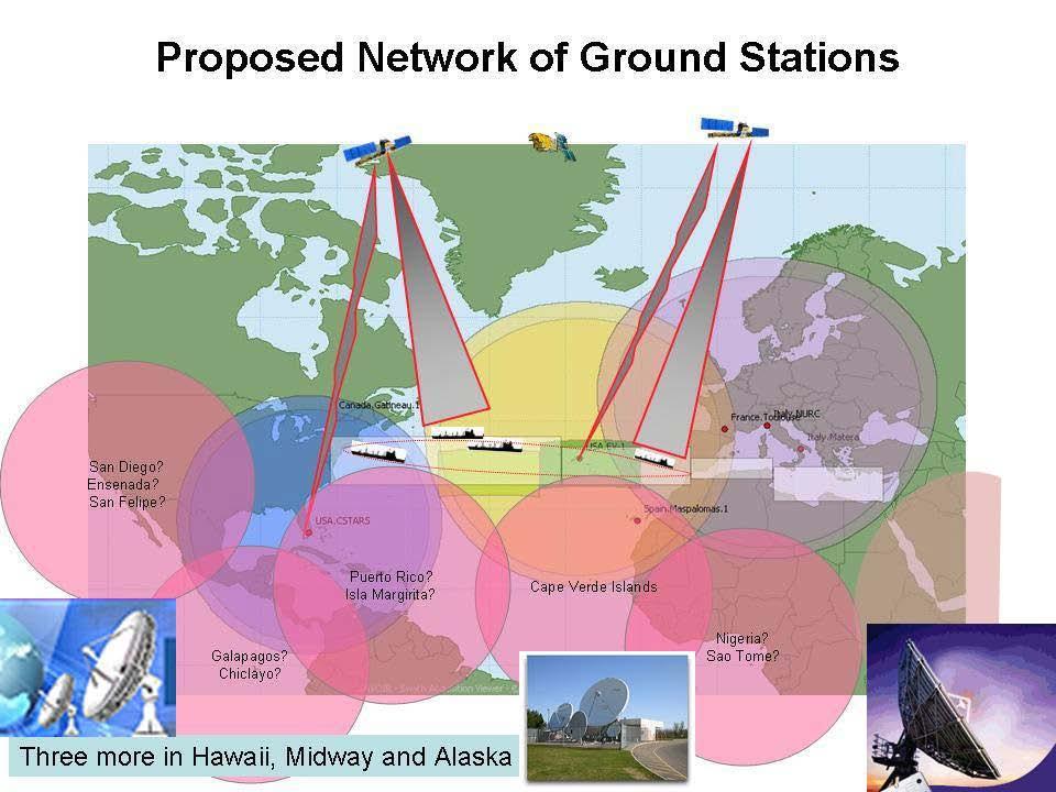
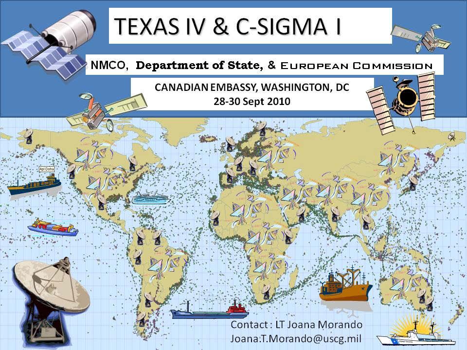
 systems To establish a mechanism for Global Maritime Awareness (GMA) Identify: Basic System Components Next Steps to Implement GMA.")
54 Purpose Achieve consensus: Exploratory Workshop With international and inter-agency partners Need to build an unclassified system using available space based (+ Terrestrial) systems To establish a mechanism for Global Maritime Awareness (GMA) Identify: Basic System Components Next Steps to Implement GMA.
55 Delayed
56
57 C-SIGMA, just a concept PPD-4, National Space Policy, June 28, 2010, emphasizes U.S. leadership in space and directs international collaboration on mutually beneficial space activities for the purpose of broadening and extending the benefits of space. To implement the President s direction the U.S. will begin the development of an open source system, utilizing government and commercial capabilities, to enhance global maritime domain awareness.


58 QUESTIONS?
*For International Stewardship of the Maritime Environment and its Resources. Photo
 *For International Stewardship of the Maritime Environment and its Resources *For Maritime Safety *For Security Photo # Providing Environmental Monitoring* # Increasing Security* # Enabling Safety Efforts*
The Ability of a Small Satellite Constellation to Tip and Cue Other Commercial Assets
 Changing the economics of space The Ability of a Small Satellite Constellation to Tip and Cue Other Commercial Assets Becky Cudzilo - Surrey Satellite US, LLC K.C. Foley - GeoEye, Inc. Chandler Smith -
satellite based maritime awareness and surveillance Italian Coast Guard Headquarters
 satellite based maritime awareness and surveillance THE ITCG S ACTIVITIES ARE PERFORMED FOR: BY LAW ITALIAN COAST GUARD IS RESPONSIBLE FOR: PERFORMING AND COORDINATING MARITIME SEARCH AND RESCUE OPERATIONS
Satellite services for maritime security
 Satellite services for ITS-T Sophia Antipolis 6 June 2007 Jean-Pierre Cauzac, CLS - Collecte Localisation Satellites 35 Are the seas becoming more dangerous? IMB report 2006 shows improvement: 239 piracy
PMAR Piracy, Maritime Awareness & Risks
 PMAR Piracy, Maritime Awareness & Risks Maritime Situational Awareness for Counter-Piracy European Commission Joint Research Centre 13 June 2012 GeoMaritime, London 1 MSA for counter-piracy study Key elements
KONGSBERG. WORLD CLASS through people, technology and dedication WORLD CLASS through people, technology and dedication
 WORLD CLASS through people, technology and dedication WORLD CLASS through people, technology and dedication Skipsdeteksjon fra radarsatellitter SkipSat Richard Hallr Kongsberg Satellite Services AS (KSAT)
KONGSBERG SATELLITE SERVICES 2017 Line Steinbakk, Director Programs. Himmel og hav - Ålesund 3. Oktober 2017
 KONGSBERG SATELLITE SERVICES 2017 Line Steinbakk, Director Programs Himmel og hav - Ålesund 3. Oktober 2017 KSAT HQ IN TROMSØ 69N Established in 1967 Kongsberg Satellite Services since 2002 World leading
Utilization of Radar data for Maritime Surveillance
 INDESO Project Utilization of Radar data for Maritime Surveillance DENDY MAHABROR MARINE RESEARCH CENTER INDESO RADAR GROUND STATION RADARSAT-2 AND COSMO-SKYMED BALI INDESO satelit VMS satelite radar vessel
Space Based Vessel Detection - Combining Earth Observation and AIS for Maritime surveillance TEXAS V and C-Σ III
 Space Based Vessel Detection - Combining Earth Observation and AIS for Maritime surveillance TEXAS V and C-Σ III Tony Bauna Director, Product and Service Development, Kongsberg Satellite Services, Tromsø,
KONGSBERG SATELLITE SERVICES Earth Observation for Maritime Operations Current Capabilities and Future Potential
 KONGSBERG SATELLITE SERVICES 2017 Earth Observation for Maritime Operations Current Capabilities and Future Potential Andreas Hay Kaljord Project Manager KSAT HQ IN TROMSØ - 69N WELCOME TO TROMSØ Established
Satellite data for Maritime Operations. Andreas Hay Kaljord Project Manager Energy, Environment & Security
 Satellite data for Maritime Operations Andreas Hay Kaljord Project Manager Energy, Environment & Security Kongsberg Satellite Services (KSAT) World leading provider within our business area Supports 85
SAR Interferometry Capabilities of Canada's planned SAR Satellite Constellation
 SAR Interferometry Capabilities of Canada's planned SAR Satellite Constellation Dirk Geudtner, Guy Séguin,, Ralph Girard Canadian Space Agency RADARSAT Follow-on Program CSA is in the middle of a Phase
Abstract. 1. Introduction
 Title: Satellite surveillance for maritime border monitoring Author: H. Greidanus Number: File: GMOSSBordMon1-2.doc Version: 1-2 Project: GMOSS Date: 25 Aug 2004 Distribution: Abstract Present day remote
It is an Interconnected World. Except in the Maritime Domain In 2008 Satellite AIS (S-AIS) Changed All that!
 Changed All that!") It is an Interconnected World Except in the Maritime Domain In 2008 Satellite AIS (S-AIS) Changed All that! Background This brief is the result of that Research, which continues to this day. Makes Regional
It is an Interconnected World Except in the Maritime Domain In 2008 Satellite AIS (S-AIS) Changed All that! Background This brief is the result of that Research, which continues to this day. Makes Regional
Remote Sensing Analysis Framework for Maritime Surveillance Application
 Remote Sensing Analysis Framework for Maritime Surveillance Application Olaf Frauenberger, Egbert Schwarz, Sergey Voinov Maritime Security Lab Neustrelitz (DFD) Maritime Big Data Workshop, 9-11 May, La
Government Agency Perspectives & Initiatives Canadian Coast Guard Laurent Tardif, Director, Safe Shipping
 Unclassified Government Agency Perspectives & Initiatives Canadian Coast Guard Laurent Tardif, Director, Safe Shipping Mariner s Workshop January 23, 2019 1 Overview 1 Context 2 Marine Fees 3 4 5 Update
Integration of AIS functionalities
 Integration of AIS functionalities by John O. Klepsvik FARGIS 05 March 01, 2005 WORLD CLASS through people, technology and dedication WORLD CLASS through people, technology and dedication KONGSBERG March
Kongsberg Satellite Services, KSAT
 SvalSat, Earth Station at 78 North Kongsberg Satellite Services, KSAT Making Sense of Space Sigmund Dehli International Sales Manager WORLD CLASS through people, technology and dedication My plan KSAT
Introduction to KOMPSAT
 Introduction to KOMPSAT September, 2016 1 CONTENTS 01 Introduction of SIIS 02 KOMPSAT Constellation 03 New : KOMPSAT-3 50 cm 04 New : KOMPSAT-3A 2 KOMPSAT Constellation KOMPSAT series National space program
Trusted for Life TM. USCG AIS Mandate. 3 rd December 10:30 am - 11:15 am
 Trusted for Life TM USCG AIS Mandate 3 rd December 10:30 am - 11:15 am The AIS Mandate McMurdo Stand 2335 CEO McMurdo UK McMurdo By the Numbers 25% Percentage of world s 406MHz beacons manufactured by
Cost Effective Control of your Coastal Waters
 Cost Effective Control of your Coastal Waters Olov Fäst SSC Airborne Systems 2013-07-03 SSC: A comprehensive space industry Founded in 1972 ~650 employees (2012) ~100 M turnover (2012) Since the start
Satellite SAR ship detections from PMAR in support of Cutlass Express
 Satellite SAR ship detections from PMAR in support of Cutlass Express Harm Greidanus, Marlene Alvarez, Tulay Cokacar, Andrea Pesaresi, Carlos Santamaria, Vladimir Kyovtorov EUR 25140 EN - 2011 The mission
SAR missions for oceanography at the European Space Agency
 SAR missions for oceanography at the European Space Agency ERS-1, ERS-2, Envisat, Sentinel-1A, Sentinel-1B, ESA 3 rd Party Missions (ALOS) Prepared by ESA teams and ESA supporting companies ESA and SAR
Canadian Space Agency program update
 Canadian Space Agency program update Briefing to the meeting of the Expert Team on Satellite Systems (ET-SAT-11) Geneva, 4 April 2017 Guennadi Kroupnik Canadian Space Agency RADARSAT-2: CURRENT OPERATIONAL
Downloaded by on April 16, DOI: /
 Polar Epsilon: Joint Space-Based Wide Area Surveillance and Support Project LCdr Robert Quinn Project Director Polar Epsilon Directorate of Space Development Phone: +1(613)945-5212 Quinn.rj2@forces.gc.ca
Integrating Spaceborne Sensing with Airborne Maritime Surveillance Patrols
 22nd International Congress on Modelling and Simulation, Hobart, Tasmania, Australia, 3 to 8 December 2017 mssanz.org.au/modsim2017 Integrating Spaceborne Sensing with Airborne Maritime Surveillance Patrols
Targeting a Safer World. Public Safety & Security
 Targeting a Safer World Public Safety & Security WORLD S MOST EFFECTIVE AND AFFORDABLE WIDE-AREA SITUATIONAL AWARENESS Accipiter provides the world s most effective and affordable wide-area situational
Targeting a Safer World
 Targeting a Safer World INTRODUCTION Accipiter Radar is a global provider of high performance radar surveillance solutions built upon its patented Radar Intelligence Network (RIN) Platform Technology.
Satellite Technologies for Fisheries Monitoring, Control and Surveillance (MCS)
") JRC IPSC Maritime Affairs 1 Satellite Technologies for Fisheries Monitoring, Control and Surveillance (MCS) Juan Cicuendez, Marlene Alvarez JRC Info Day Madrid, 2 June 2010 IPSC - Institute for the Protection
JRC IPSC Maritime Affairs 1 Satellite Technologies for Fisheries Monitoring, Control and Surveillance (MCS) Juan Cicuendez, Marlene Alvarez JRC Info Day Madrid, 2 June 2010 IPSC - Institute for the Protection
The RCAF S&T program and the All Domain
 The RCAF S&T program and the All Domain Situational Awareness (ADSA) S&T Program) CADSI AIR FORCE Martin McKinnon Director S&T Air (DSTA-3) Assistant Deputy Minister, Science and Technology Department
the use of satellite radar to improve surveillance of oil pollution over large areas
 Groupe de travail ORFEO - Mer et Littoral Réunion du 14 octobre 2004 the use of satellite radar to improve surveillance of oil pollution over large areas François Parthiot Cedre - Delegate for the Mediterranean
Demonstrator of a Data Processing Centre (DPC) for satellite-based AIS services
 for satellite-based AIS services") Page 1 Demonstrator of a Data Processing Centre (DPC) for satellite-based AIS services 19/20 April 2012 gfabritius@cls.fr Overview of the presentation Page 2 Introducing CLS Introducing AIS / SAT-AIS Scope
Page 1 Demonstrator of a Data Processing Centre (DPC) for satellite-based AIS services 19/20 April 2012 gfabritius@cls.fr Overview of the presentation Page 2 Introducing CLS Introducing AIS / SAT-AIS Scope
Copyright 2016 Raytheon Company. All rights reserved. Customer Success Is Our Mission is a registered trademark of Raytheon Company.
 Make in India Paradigm : Roadmap for a Future Ready Naval Force Session 9: Coastal Surveillance, Response Systems and Platforms Nik Khanna, President, India April 19, 2016 "RAYTHEON PROPRIETARY DATA THIS
RADAR SATELLITES AND MARITIME DOMAIN AWARENESS
 RADAR SATELLITES AND MARITIME DOMAIN AWARENESS J.K.E. Tunaley Corporation, 114 Margaret Anne Drive, Ottawa, Ontario K0A 1L0 (613) 839-7943 Report Documentation Page Form Approved OMB No. 0704-0188 Public
ERS/ENVISAT ASAR Data Products and Services
 ERS/ENVISAT ASAR Data Products and Services Andrea Celentano Business Manager celentan@eurimage.com What is Eurimage? Founded in 1989 Current shareholders: Since 1989 Commercial Partner of the European
GMDSS modernisation and e-navigation: spectrum needs
 ETSI Workshop "Future Evolution of Marine Communication", 7-8 November 2017, Sophia Antipolis, France GMDSS modernisation and e-navigation: spectrum needs Karlis Bogens BR Terrestrial Services Department
KOMPSAT Constellation. November 2012 Satrec Initiative
 KOMPSAT Constellation November 2012 Satrec Initiative KOMPSAT Constellation KOMPSAT National program Developed and operated by KARI (Korea Aerospace Research Institute) Dual use : Government & commercial
COMMUNICATIONS FOR MARITIME SAFETY AND EFFICIENCY. Francis Zachariae, Secretary-General, IALA
 COMMUNICATIONS FOR MARITIME SAFETY AND EFFICIENCY Francis Zachariae, Secretary-General, IALA IALA and its Purpose Non profit, international technical association established in 1957 Two Goals aimed at
An Introduction to INDUSTRY PARTNERS 25/05/2017. Military Army & Air Force. Government Defense & Rescue. Aviation Maritime Military. Other.
 An Introduction to 1 INDUSTRY PARTNERS Aviation Maritime Military Coast Guard & Navy Military Army & Air Force Government Defense & Rescue Other Commercial Commercial/Workboat Navy Air Force SAR Agencies
The ERS contribution to Oil Spill Monitoring - From R&D towards an operational service -
 The ERS contribution to Oil Spill Monitoring - From R&D towards an operational service - J.P. Pedersen, T.Bauna, L.G. Seljelv, L. Steinbakk, R.T.Enoksen Tromsø Satellite Station, N-9291 Tromsø, Norway
Port Security and Technology - the U.S. Perspective. Michael S. Bruno Stevens Institute of Technology March 14, 2012
 Port Security and Technology - the U.S. Perspective Michael S. Bruno Stevens Institute of Technology March 14, 2012 CSR A Department of Homeland Security National Center of Excellence for Port Security
Using satellite technology to monitor illegal, unreported, and unregulated (IUU) fishing
 fishing") Using satellite technology to monitor illegal, unreported, and unregulated (IUU) fishing Mark Richardson The Pew Charitable Trusts Blue Planet Symposium, June 2, 2017 The global threat of IUU fishing Illegal,
Using satellite technology to monitor illegal, unreported, and unregulated (IUU) fishing Mark Richardson The Pew Charitable Trusts Blue Planet Symposium, June 2, 2017 The global threat of IUU fishing Illegal,
Affordable space based radar for homeland security
 Changing the economics of space Affordable space based radar for homeland security Adam Baker Brent Abbott Phil Whittaker Rachel Bird Luis Gomes Summary Why Radar? However: Radar data is expensive Users
MEOSAR Performance Overview. SAR Controllers Training March 2016 Mickey Fitzmaurice NOAA Senior Systems Engineer
 MEOSAR Performance Overview SAR Controllers Training 2016 1 3 March 2016 Mickey Fitzmaurice NOAA Senior Systems Engineer MEOSAR: AN IMPROVED SYSTEM CONCEPT MEO sat at 20,000 km LEO sat at 800-900 km MEO
Coastal Surveillance. SCANTER Radar Solutions
 Coastal Surveillance SCANTER Radar Solutions Protecting Your Coastlines and Maritime Domain We provide radar coverage of the coastline to detect and track all types of surface vessels and air targets.
WHAT IS NEXT IN EARTH OBSERVATION. SkyMed Mission
 WHAT IS NEXT IN EARTH OBSERVATION COSMO-SkyMed SkyMed Mission Paolo Ammendola Italian Space Agency Florence, Sept. 19, 2001 ammendola@asi asi.it THE NEEDS Market studies indicate that the value of the
Collaborative use of SAR and AIS data from NovaSAR-S for Maritime Surveillance
 Collaborative use of SAR and AIS data from NovaSAR-S for Maritime Surveillance Lotfi Achiri, University of Surrey, Surrey Space Centre, l.achiri@surrey.ac.uk, UK Raffaella Guida, University of Surrey,
Innovative Maritime Surveillance Capabilities. Pre-operational Services for Highly. Development of. Maria Angelucci, e-geos
 Development of Pre-operational Services for Highly Innovative Maritime Surveillance Capabilities ASI Workshop - 7 th Framework Program Rome, June 27 th, 2012 Maria Angelucci, e-geos 1 Figures Start date:
NovaSAR-S - Bringing Radar Capability to the Disaster Monitoring Constellation
 Changing the economics of space NovaSAR-S - Bringing Radar Capability to the Disaster Monitoring Constellation SSTL: Philip Davies, Phil Whittaker, Rachel Bird, Luis Gomes, Ben Stern, Prof Sir Martin Sweeting
Introduction Objective and Scope p. 1 Generic Requirements p. 2 Basic Requirements p. 3 Surveillance System p. 3 Content of the Book p.
 Preface p. xi Acknowledgments p. xvii Introduction Objective and Scope p. 1 Generic Requirements p. 2 Basic Requirements p. 3 Surveillance System p. 3 Content of the Book p. 4 References p. 6 Maritime
Development of Microsatellite to Detect Illegal Fishing MS-SAT
 Development of Microsatellite to Detect Illegal Fishing MS-SAT Ernest S. C. P. Bintang A.S.W.A.M. Department of Aerospace Engineering Faculty of Mechanical and Aerospace Engineering Institut Teknologi
Marine Earth Observation & Applications at University College Cork
 Marine Earth Observation & Applications at University College Cork Rory Scarrott, with input from Eimear Tuohy & Chiara Pratola 2 nd Irish Industry Space Day, Hibernian Club, Dublin, September 2 nd 2015
School of Rural and Surveying Engineering National Technical University of Athens
 Laboratory of Photogrammetry National Technical University of Athens Combined use of spaceborne optical and SAR data Incompatible data sources or a useful procedure? Charalabos Ioannidis, Dimitra Vassilaki
Change Detection using SAR Data
 White Paper Change Detection using SAR Data John Wessels: Senior Scientist PCI Geomatics Change Detection using SAR Data The ability to identify and measure significant changes in target scattering and/or
Canada s. Third. Generation. High Frequency. Surface Wave. Radar System
 Canada s Third Generation High Frequency Surface Wave Radar System by Peter Moo, Tony Ponsford, David DiFilippo, Rick McKerracher, Nathan Kashyap, and Yannick Allard Introduction The granting of coastal
Enhanced Maritime Traffic Picture for the Canadian Arctic
 Enhanced Maritime Traffic Picture for the Canadian Arctic Giulia Battistello*, Martin Ulmke*, Camilla Mohrdieck** (*) Fraunhofer FKIE - Sensor Data and Information Fusion Department - Wachtberg, Germany
LRIT spectrum, cybersecurity and other ITU related activities
 IMSO Seminar Effective Implementation and Management of the LRIT System 15 16 February 2018, London, UK LRIT spectrum, cybersecurity and other ITU related activities Nikolai Vassiliev Chief, Terrestrial
The Role of RADARSAT-2 for Flood and Agriculture Monitoring
 The Role of RADARSAT-2 for Flood and Agriculture Monitoring Gordon Staples MDA Richmond, BC, CANADA gstaples@mda.ca RESTRICTION ON USE, PUBLICATION OR DISCLOSURE OF PROPRETIARY INFORMATION This document
Presentation to the UN COPUOS STSC LTSSA Workshop. ISO Space Standards. 14 February 2013
 Presentation to the UN COPUOS STSC LTSSA Workshop ISO Space Standards 14 February 2013 by Frederick A. Slane Head, U.S. Delegation ISO TC20/SC14 Executive Director Space Infrastructure Foundation Purpose
Maritime Geo-Fence Letter Report
 Report No. CG-D-10-16 Maritime Geo-Fence Letter Report Authors: Irene Gonin and Gregory Johnson Distribution Statement A: Approved for public release; distribution is unlimited. July 2016 Classification
NEREIDS: New concepts in maritime surveillance for consolidating operational developments
 SEASAR12 WORKSHOP, TROMSO, 06-12 NEREIDS: New concepts in maritime surveillance for consolidating operational developments Property of GMV All rights reserved SUMMARY NEREIDS PROJECT NEREIDS CHALLENGES
Space-Based AIS: Contributing to Global Safety and Security
 Space-Based AIS: Contributing to Global Safety and Security J.S. Cain 1, E. Meger 2, COM DEV Limited 155 Sheldon Ave, Cambridge, Ontario, Canada. Abstract Global trade continues to increase and today more
Co-ReSyF RA lecture: Vessel detection and oil spill detection
 This project has received funding from the European Union s Horizon 2020 Research and Innovation Programme under grant agreement no 687289 Co-ReSyF RA lecture: Vessel detection and oil spill detection
SAR and Intercept Features
 SAR and Intercept Features TZTL12F/15F v6.01 and later are compatible with useful functions of creating SAR (Search And Rescue) Patterns and Intercepting a target vessel that can be utilized in Coast Guard
FREQUENCIES FOR DISTRESS AND SAFETY, SEARCH AND RESCUE AND EMERGENCIES
 FREQUENCIES FOR DISTRESS AND SAFETY, SEARCH AND RESCUE AND EMERGENCIES Given the global nature of travel with the potential risk of accidents the international community has agreed that the use of certain
Regional and Inter-Regional Seminar and Workshop on Search and Rescue
 Regional and Inter-Regional Seminar and Workshop on Search and Rescue Mahe, Seychelles 19-22 July 2016 1 Agenda Aireon Introduction Space-Based ADS-B Overview Aireon System Deployment Status Aireon ALERT
ICAO Inter-regional SAR Workshop 2016
 ICAO Inter-regional SAR Workshop 2016 Global Aeronautical Distress and Safety System (GADSS) - Implications for Search And Rescue Services Dave Edwards U.S. Coast Guard Chairman, International Civil Aviation
CENTRA Technology, Inc. V 1.2
 CENTRA Technology, Inc. V 1.2 International Products Catalog 2013 CENTRA works to develop customized, affordable, and fully exportable technical solutions for our international clients priority missions.
Sensors, Tools and the Common Operating Picture. Sensors, Tools and the Common Operating Picture 14 th April Middleburg
 Sensors, Tools and the Common Operating Picture 14 th April 2015 - Middleburg Aptomar Established in 2005 Owned by Statoil, Investinor, Proventure Seed, Verdane Capitol Have developed and control all IPR
EUROPEAN COMMISSION SEVENTH FRAMEWORK PROGRAMME SEC GA No
 EUROPEAN COMMISSION SEVENTH FRAMEWORK PROGRAMME SEC-2013.2.4-2 GA No. 607685 Protection Measures for Merchant Ships Deliverable No. PROMERC D1.2 Deliverable Title Scenario Report Dissemination level Written
720 VHF/UHF 80 to 500 MHz Maritime and Coastal Surveillance
 720 VHF/UHF 80 to 500 MHz Maritime and Coastal Surveillance Radio Direction Finding (RDF) System The TCI Model 720 is a high-performance radio direction finder that can be easily integrated into maritime
Security Systems Division
 Security Systems Division SIVE A PIONEER MARITIME BORDER SURVEILLANCE SYSTEM. WHAT IS BEYOND? Pros and cons of the SIVE system today in the new coastal and deepwater border scenario and our vision of a
RADARSAT-2 Modes and Applications
 RADARSAT-2 Modes and Applications Gordon Staples MDA Geospatial Services February 6, 2017 1 Introduction RADARSAT-2 was developed to meet operational needs via a versatile space segment and a responsive
Observing Dry-Fallen Intertidal Flats in the German Bight Using ALOS PALSAR Together With Other Remote Sensing Sensors
 Observing Dry-Fallen Intertidal Flats in the German Bight Using ALOS PALSAR Together With Other Remote Sensing Sensors Martin Gade, Institut für Meereskunde & Kerstin Stelzer Brockmann Consult Outline
Table Satellites used for observations by members of the Disaster Charter and others (except Daichi)
") 2.1.4 Cooperation with from overseas institutions JAXA asked Sentinel Asia and, on behalf of the Cabinet Office, the Disaster Charter to carry out emergency observations immediately after the earthquake
2.1.4 Cooperation with from overseas institutions JAXA asked Sentinel Asia and, on behalf of the Cabinet Office, the Disaster Charter to carry out emergency observations immediately after the earthquake
DHS/U.S. Customs and Border Protection -
 DHS/U.S. Customs and Border Protection - Technology Solutions Program Office (TSPO) DHS/ Unmanned Aircraft System (UAS) October 31, 2006 1 Purpose Provide overall UAS program overview Program Description
Graham Stickler Esri Ocean GIS Forum, Redlands, CA, 5-7 November 2013
 Graham Stickler Esri Ocean GIS Forum, Redlands, CA, 5-7 November 2013 Imagine.. A world with no horizons Coastal Coverage Space View Satellite Constellation 6 satellite polar orbiting + 1 equatorial constellation
GNSS in Maritime and Education in Egypt
 GNSS in Maritime and Education in Egypt GNSS IN MARITIME PORTS SHIPS PORTS WATERWAYS GNSS maritime applications will help to improve: navigation. Ship operations. Traffic management. Seaport operations.
The Future in Marine Radio Communication GMDSS. Department of Transportation United States Coast Guard
 The Future in Marine Radio Communication GMDSS Department of Transportation United States Coast Guard Do you use a Maritime Radio System? If so, the new Global Maritime Distress and Safety System (GMDSS)
TerraSAR-X Applications Guide
 TerraSAR-X Applications Guide Extract: Maritime Monitoring: Ship Detection April 2015 Airbus Defence and Space Geo-Intelligence Programme Line Maritime Monitoring: Ship Detection Issue Maritime security
Multi Sensor Data Fusion
 Multi Sensor Data Fusion for improved maritime traffic monitoring in the Canadian Arctic Giulia Battistello*, Martin Ulmke*, Javier Gonzalez*, Camilla Mohrdieck** (*) Fraunhofer FKIE Sensor Data and Information
Sentinel-1 System Overview
 Sentinel-1 System Overview Dirk Geudtner, Rámon Torres, Paul Snoeij, Malcolm Davidson European Space Agency, ESTEC Global Monitoring for Environment and Security (GMES) EU-led program aiming at providing
Leadership built upon facts Cobham SATCOM Maritime communication solutions
 Friday, 10 April 2015 The most important thing we build is trust MARINE FleetBroadband VSAT solutions Satellite TV GMDSS VHF and MF/HF radios AIS, Navtex LAND BGAN Portable and Vehicular terminals VSAT
EMSA Additional Dataset Status 31 st March 2015
 EMSA Additional Dataset Status 31 st March 2015 DWH_MG2_EMSA_ADD_001a: _rush_optical_hr1... 2 DWH_MG2_EMSA_ADD_001b: _rush_optical_hr2... 3 DWH_MG2_EMSA_ADD_002a: ew acquisition_rush_optical_hr1... 4 DWH_MG2_EMSA_ADD_002b:
Document code: 6/2/INF Date: Submitted by: Chairman DRAFT PROPOSAL FOR OPERATIONAL DEFINITIONS OF AIS COVERAGE.
 HELSINKI COMMISSION HELCOM AIS EWG 21/2010 Expert Working Group for Mutual Exchange and Deliveries of AIS data 21 st Meeting Gdynia, Poland, 27-28 October 2010 Agenda Item 6 Definition of AIS coverage
A CONCEPT FOR NATURAL GAS TRANSMISSION PIPELINE MONITORING BASED ON NEW HIGH-RESOLUTION REMOTE SENSING TECHNOLOGIES
 A CONCEPT FOR NATURAL GAS TRANSMISSION PIPELINE MONITORING BASED ON NEW HIGH-RESOLUTION REMOTE SENSING TECHNOLOGIES Werner Zirnig - Ruhrgas Aktiengesellschaft Dieter Hausamann - DLR German Aerospace Center
Ian D Souza (1), David Martin (2)
, David Martin (2)") NANO-SATTELITE DEMONSTRATION MISSION: THE DETECTION OF MARITIME AIS SIGNALS FROM LOW EARTH ORBIT SMALL SATELLITE SYSTEMS AND SERVICES SYMPOSIUM Pestana Conference Centre Funchal, Madeira - Portugal 31
NANO-SATTELITE DEMONSTRATION MISSION: THE DETECTION OF MARITIME AIS SIGNALS FROM LOW EARTH ORBIT SMALL SATELLITE SYSTEMS AND SERVICES SYMPOSIUM Pestana Conference Centre Funchal, Madeira - Portugal 31
A Space-Based Solution for Illegal, Unregulated & Unreported Fishing. Emmanouil Detsis, International Space University
 Project Catch A Space-Based Solution for Illegal, Unregulated & Unreported Fishing Emmanouil Detsis, International Space University Project Catch COPUOS Presentation Team Project Oceans International Intercultural
ORBCOMM Machine-To-Machine (M2M)
") ORBCOMM Machine-To-Machine (M2M) Texas V & C-Sigma November 2012 Global M2M Connecting the World s Assets Machine-To-Machine (M2M) Applications Global M2M Wireless Network for Narrowband Data Applications
ORBCOMM Machine-To-Machine (M2M) Texas V & C-Sigma November 2012 Global M2M Connecting the World s Assets Machine-To-Machine (M2M) Applications Global M2M Wireless Network for Narrowband Data Applications
SAFELINK EPIRB (WITH GPS) 406 Beacon Specification. Meets the requirements of international standards:
 406 Beacon Specification. Meets the requirements of international standards:") SAFELINK EPIRB (WITH GPS) 406 Beacon Specification Meets the requirements of international standards: IEC 61097 2 2008, IEC/EN 60945 Fourth edition (2002 08), ETSI 300 066 v1.3.1 (2001 01), RTCM SC110
SAFELINK EPIRB (WITH GPS) 406 Beacon Specification Meets the requirements of international standards: IEC 61097 2 2008, IEC/EN 60945 Fourth edition (2002 08), ETSI 300 066 v1.3.1 (2001 01), RTCM SC110
Can Satellite Image Analysis Replace Manual Digitization?
 Can Satellite Image Analysis Replace Manual Digitization? GeoDATA London 30 th Nov 2017 LUCY KENNEDY Spottitt CEO Lucy.Kennedy@spottitt.com +44 772 594 4643 Agenda Why develop processes and services based
ESA IAP Blue Belt demonstration project:
 Page 1 ESA IAP Blue Belt demonstration project: supporting the European Maritime Safety Agency (EMSA) Blue Belt Project, by providing a service based on satellite based AIS data complementing the terrestrial
CHAPTER TWENTY COOPERATION. The objective of this Chapter is to facilitate the establishment of close cooperation aimed, inter alia, at:
 CHAPTER TWENTY COOPERATION ARTICLE 20.1: OBJECTIVE The objective of this Chapter is to facilitate the establishment of close cooperation aimed, inter alia, at: strengthening the capacities of the Parties
Special Projects Office. Mr. Lee R. Moyer Special Projects Office. DARPATech September 2000
 Mr. Lee R. Moyer DARPATech 2000 6-8 September 2000 1 CC&D Tactics Pose A Challenge to U.S. Targeting Systems The Challenge: Camouflage, Concealment and Deception techniques include: Masking: Foliage cover,
How Automatic Identification System (AIS) Is Being Used to Improve Navigation Safety Lock Operations Management Application Michael Winkler
 Is Being Used to Improve Navigation Safety Lock Operations Management Application Michael Winkler") How Automatic Identification System (AIS) Is Being Used to Improve Navigation Safety Lock Operations Management Application Michael Winkler June 2016 LOMA system overview USCG AIS data capabilities: AIS
How Automatic Identification System (AIS) Is Being Used to Improve Navigation Safety Lock Operations Management Application Michael Winkler June 2016 LOMA system overview USCG AIS data capabilities: AIS
Prague - 29 June 2009 A. COLETTA COLETTA. COSMO-SkyMed Mission: COSMO-SkyMed Mission. Application and Data Access
 A. A. COLETTA COLETTA COSMO-SkyMed COSMO-SkyMed Mission Mission Manager Manager ITALIAN ITALIAN SPACE SPACE AGENCY AGENCY COSMO-SkyMed Mission: Application and Data Access The COSMO-SkyMed PROGRAMME The
Limitations of Satellite AIS: Time Machine Wanted!
 Limitations of Satellite AIS: Time Machine Wanted! Eric Meger CEO, Maerospace Corporation eric.meger@!maerospace.com 3 October 2013 Maritime Domain Awareness is one of the most significant national and
COPERNICUS COLLABORATIVE GROUND SEGMENT TO SUPPORT MARITIME SITUATIONAL AWARENESS
 COPERNICUS COLLABORATIVE GROUND SEGMENT TO SUPPORT MARITIME SITUATIONAL AWARENESS D. Krause*, E. Schwarz, H. Damerow, German Aerospace Center (DLR), German Remote Sensing Data Center (DFD), Kalkhorstweg
Satellite technology to prevent and respond in cases of maritime accidents
 United Nations International Conference on Space-based Technologies for Disaster Management "Disaster risk identification, assessment and monitoring" 23-25 October 2013, Beijing, China. Satellite technology
L AGENCE NATIONALE DES FREQUENCES (ANFR) From Titanic to satellite from Morse to digital Entry in a new era for the maritime community
 From Titanic to satellite from Morse to digital Entry in a new era for the maritime community") L AGENCE NATIONALE DES FREQUENCES (ANFR) From Titanic to satellite from Morse to digital Entry in a new era for the maritime community ITU regional seminar 6-8 June 2018 St-Petersburg, Russian Federation
L AGENCE NATIONALE DES FREQUENCES (ANFR) From Titanic to satellite from Morse to digital Entry in a new era for the maritime community ITU regional seminar 6-8 June 2018 St-Petersburg, Russian Federation