EE Chapter 14 Communication and Navigation Systems
|
|
|
- Brandon Wright
- 5 years ago
- Views:
Transcription
1 EE Chapter 14 Communication and Navigation Systems Two way radio communication with air traffic controllers and tower operators is necessary. Aviation electronics or avionics: Avionic systems cover many controlling systems in an aircraft such as communication radio, navigation systems, weather detection systems and flight management systems. All modern avionic systems conform to Aeronautical Radio Incorporated (ARINC) standards. ARINC is a corporation established by foreign and domestic airlines, aircraft manufacturers and transport companies to set standards for aircraft systems. ARINC was incorporated in 1929 as Aeronautical Radio, Incorporated. It was chartered by the Federal Radio Commission (which later became the Federal Communications Commission) in order to serve as the airline industry s single licensee and coordinator of radio communication outside of the government. ARINC is a major provider of transport communications and systems engineering solutions for eight industries: aviation, airports, defense, government, healthcare, networks, security, and transportation. ARINC 500 and 700 standards for communication, navigation and identification systems: The 500 Series describes analog avionics equipment used on aircraft such as the Boeing 727, Douglas DC 9, DC 10, Boeing 737 and 747, and Airbus A300. ARINC 573 is a standard format for data parameters recorded by digital flight data recorder and flight data recorder required by the FAA and ICAO. The 700 Series describes digital systems and equipment installed on aircraft of digital avionics systems, including data link protocols.[6] ARINC 708 is the standard for airborne weather radar. It defines the airborne weather radar characteristics for civil and military aircraft. This standard also defines the way to control and get information from the radar. ARINC 717 Flight Data Recorder for Commercial Aircraft ARINC 739 is the standard for communication between the MCDU and the systems attached to it. ARINC 741 is the standard for a first generation L band satellite data unit. ARINC 746 is the standard for a cabin telecommunications unit, based on Q.931 and CEPT E1. ARINC 761 is the standard for a second generation L band satellite data unit, also called Swift64 by operator Inmarsat. ARINC 763 is the standard for a generic avionics file server and wireless access points. ARINC 781 is the standard for a third generation L band satellite data unit, also called SwiftBroadband by operator Inmarsat. ARINC 791 is the in work standard for a Ku band satellite data unit. 1

2 Communications Radio communication systems for aircraft are primarily for the purpose of air traffic control, however, commercial aircraft also utilize a range of high frequencies for communicating with ground stations and other aircraft. Communications for air traffic control are in the VHF band ( MHz range). High frequency communication systems Operating frequency range 2 to 30 MHz. HF communication systems are used for long distance radio transmissions to provide two way voice communication with ground stations or other aircraft. Antenna tuning for all transmission frequencies is accomplished automatically by means of an antenna coupler system. HF communication systems are not employed on all aircraft. VHF communication systems VHF communication systems are employed largely for controlling air traffic. The advantage is that the signals are not often distorted or rendered by static and other types of interference. 2
 in US are systems designed to reduce the amount of voice communication on the increasingly crowded communications frequencies. Federal Communication Commission (FCC, www.fcc.")
3 Antenna locations for communications and navigation equipment: Digital air/ground Communications services (AIRCOM) in Europe and Australia and ARINC Communication Addressing and Reporting System (ACARS) in US are systems designed to reduce the amount of voice communication on the increasingly crowded communications frequencies. Federal Communication Commission (FCC, is a government agency to control all electromagnetic emissions in USA and also issue licenses. Satellite Communication (SATCOM) equipment is typically found on aircraft that make intercontinental flights. Common HF communication radios will transmit long distance, however, they are susceptible to interference. SATCOM equipment utilizes frequencies that are relatively static free but normally limited to line of sight distances. SATCOM system consists of three subsystems: the ground earth station, the aircraft earth station and the satellite system. See Fig (pp.301) The satellites act as a relay station for various SATCOM signals. The satellites receive and transmit in L band frequencies (e.g MHz) when communicating with aircraft and in C band frequencies (e.g. 4 6 GHz) when communicating with ground stations. 3


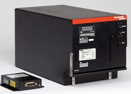
4 SATCOM Product from Rockwell Collins ( 4
5 14.2 Navigation Systems With advancements of electronics (solid state devices), microprocessors and digital signal processing, navigation systems have been improved over the years. Various systems are available for different applications. Automatic Direction Finder System (ADF): To determine the aircraft s position or direction of the radio stations being received. The principal units of an ADF system are a radio receiver, which includes the amplifiers and various other electronic components, a loop antenna, a sense antenna, a radio magnetic indicator, and a remote control unit, or control panel. Instrument Landing System (ILS): To allow pilots the opportunity to land their aircraft with the aid of instrument references from glide slope transmitter (provide horizontal direction reference and a vertical reference) and runway localizer (produce directional reference signal). If an airplane is approaching the runway and is above the glide path, the 90 Hz signal will predominate; and if the airplane is below the glide path, the 150 Hz signal will predominate. Other systems: Tactical Air Navigation (TACAN), Microwave Landing System (MLS) or Time reference Scanning beam Microwave Landing System (TRSB), Radio Tuning Systems, Flight Management System (FMS) 14.3 Long range Navigation Systems LOng Rang Navigation (LORAN) is a system that operates in the LF range (30 to 300 khz) and utilizes pulse transmitting stations to provide the signals necessary for navigational computation. Inertial Navigation System: The advantage is no external radio signals are required. The system determines an aircraft s position by using Newton s laws of inertia. Global Positioning System (GPS): The system consists of three independent segments: the space segment, the control segment and the user segment. The basic idea is to know the distance and location of three or more points (from satellites), exact location can be determined. The satellites transmit a location and timing signal to the user s receiver. The distance to a satellite is determined by measuring the travel time of the transmitted signal. Knowing the speed of radio wave propagation (the speed of light), the receiver calculates the distance to the satellites. See Fig , pp Integrated Navigation and Flight Systems: A completely integrated navigation and flight system includes flight instrumentation, navigation systems, communication systems, and the automatic flight system. Air traffic Control (ATC) Transponder: Transponder is an automatic receiver and transmitter that can receive a signal from a ground station and then send a reply back to the station. There are three modes of transponder: A, C and S (read details on page 321). 5
6 Traffic Alert and Collision Avoidance System (TCAS): Major components are 1) the receiver transmittercomputer unit, 2) two display units, 3) one or two mode S transponders, 4) a system with control panel and 5) the required antennas. If the receiver identifies a potential threat, an aural and visual advisory is displayed to the flight crew. The resolution advisory will offer either corrective or preventive maneuver that will help to avoid the collision. TCAS does not control the aircraft, but it only offers suggested maneuvers to the flight crew. Radar Altimeter: Radar altimeters were developed to give an accurate indication of aircraft altitude above ground level (AGL). It works by transmitting a VHF signal downward from the aircraft and receiving the reflected signal. A radar altimeter can determine the aircraft s AGL altitude. Integrated Avionics Processor System (IAPS): This system is designed to function as a central distribution network for virtually all the avionics of an aircraft. It coordinates many systems such as weather radar, instrument display unit, flight management system, flight control system, radio sensor system, aircraft data acquisition system, air data system and the altitude heading system. Flight Data and Voice Recorders: The system must monitor both flight parameters and flight deck voice activities. A flight data recorder is housed in a crushproof container located near the tail section of the aircraft Radar RADAR (RAdio Detecting And Ranging): Radio equipment which utilizes reflected pulse signals to locate and determine the distance to any reflecting object within its range. This equipment was developed to a high level of performance by Great Britain and the United States during World War II for the detection of enemy aircraft and surface vessels. The air carrier industry quickly recognized the advantages of early weather detection using radar. Radar operates on an echo principle in which high energy radio waves are directed in a beam toward a reflecting target. The beam of pulses is actually something like a stream of bullets from a machine gun, with a relatively long space between each pulse of energy. When the pulse of energy strikes the target, which may be a mountain, rain clouds, or an airplane, a portion of the pulse is reflected back to the receiving section of the radar. At A the pulse has just been emitted from the airplane radar antenna. At this point a pip appears on the radar scope At C the pulse is striking a rain cloud. A portion of the pulse is reflected by the cloud and returns toward the airplane, as shown at D. When the reflected pulse reaches the airplane at E, a second, smaller pip appears on the radar screen. The time between the two pips indicates the distance from the airplane to the cloud. At F another pulse is emitted from the radar antenna. A typical radar signal may consist of a carrier wave of 8,000 MHz broken into pulses with a duration of 1 μsec and spaced at intervals of 1/400 s or 2,500 μsec. This would be a ratio of roughly 2,500:1 for the time of no signal to the time of signal. It must be pointed out that the ratio of the length of a pulse to the time of no signal varies considerably with the frequency, which range from 1000 to 26,500 MHz. 6

7 Two of the most commonly employed scans for radar are the A scan and the P scan. The A scan produces a horizontal line on the face of the CRT monitor as the beam of electrons moves across the fluorescent surface. The horizontal line is used to establish the distance of the target from the radar transmitter. The P scan of radar scope may be called the plan position indicator (PPI), since it indicates both the distance and direction (azimuth) of the target. On the face of the PPI scope, the time trace starts at the same time that a pulse is transmitted from the radar antenna, and the reflected pulses cause bright spots along the trace line. Type A Type P 7


8 Figures show the application of radar system in military (L) and passenger (R) aircrafts. A weather mapping system is basically a radio receiver designed to detect thunderstorm activity and display a map of that activity on a display. The convective wind shear creates static electric charges that must discharges when they reach a certain voltage level. Since the number of static discharges increases with the severity of the storm, a weather mapping system can count the discharges to determine the storm s intensity. References: Textbooks # 1 and # 2 EE Aircraft Electricity and Electronics Asst. Prof. Thavatchai Tayjasanant, Ph.D. 8
AIRCRAFT AVIONIC SYSTEMS
 AIRCRAFT AVIONIC SYSTEMS B-777 cockpit Package C:\Documents and ettings\administrato Course Outline Radio wave propagation Aircraft Navigation Systems - Very High Omni-range (VOR) system - Instrument Landing
Introduction to: Radio Navigational Aids
 Introduction to: Radio Navigational Aids 1 Lecture Topics Basic Principles Radio Directional Finding (RDF) Radio Beacons Distance Measuring Equipment (DME) Instrument Landing System (ILS) Microwave Landing
Communication and Navigation Systems for Aviation
 Higher National Unit Specification General information for centres Unit title: Communication and Navigation Systems for Aviation Unit code: F0M3 35 Unit purpose: This Unit is designed to allow candidates
NAVIGATION INSTRUMENTS - BASICS
 NAVIGATION INSTRUMENTS - BASICS 1. Introduction Several radio-navigation instruments equip the different airplanes available in our flight simulators software. The type of instrument that can be found
Engineering. Aim. Unit abstract. QCF level: 6 Credit value: 15
 Unit T22: Avionic Systems Engineering Unit code: R/504/0134 QCF level: 6 Credit value: 15 Aim The aim of this unit is to provide learners with a detailed knowledge and understanding of a wide range of
Regulations. Aeronautical Radio Service
 Regulations Aeronautical Radio Service Version 1.0 Issue Date: 30 December 2009 Copyright 2009 Telecommunications Regulatory Authority (TRA). All rights reserved. P O Box 26662, Abu Dhabi, United Arab
Copyrighted Material - Taylor & Francis
 22 Traffic Alert and Collision Avoidance System II (TCAS II) Steve Henely Rockwell Collins 22. Introduction...22-22.2 Components...22-2 22.3 Surveillance...22-3 22. Protected Airspace...22-3 22. Collision
INTERFERENCE FROM PASSENGER-CARRIED
 E L E C T R O M A G N E T I C INTERFERENCE FROM PASSENGER-CARRIED PORTABLE ELECTRONIC DEVICES Operators of commercial airplanes have reported numerous cases of portable electronic devices affecting airplane
Public Workshop on Optimising the Use of the Radio Spectrum by the Public Sector in the EU. Applications and Technologies
 Public Workshop on Optimising the Use of the Radio Spectrum by the Public Sector in the EU Applications and Technologies John Burns, Aegis Systems Ltd 1st April 2008 0 Scope of Presentation Overview of
An Introduction to Airline Communication Types
 AN INTEL COMPANY An Introduction to Airline Communication Types By Chip Downing, Senior Director, Aerospace & Defense WHEN IT MATTERS, IT RUNS ON WIND RIVER EXECUTIVE SUMMARY Today s global airliners use
10 Secondary Surveillance Radar
 10 Secondary Surveillance Radar As we have just noted, the primary radar element of the ATC Surveillance Radar System provides detection of suitable targets with good accuracy in bearing and range measurement
Exam questions: AE3-295-II
 Exam questions: AE3-295-II 1. NAVIGATION SYSTEMS (30 points) In this question we consider the DME radio beacon. [a] What does the acronym DME stand for? (3 points) DME stand for Distance Measuring Equipment
Radiocommunications Regulations (General User Radio Licence for Aeronautical Purposes) Notice 2016
 Notice 2016") Radiocommunications Regulations (General User Radio Licence for Aeronautical Purposes) Notice 2016 Pursuant to section 111 of the Radiocommunications Act 1989 and Regulation 9 of the Radiocommunications
Radiocommunications Regulations (General User Radio Licence for Aeronautical Purposes) Notice 2016 Pursuant to section 111 of the Radiocommunications Act 1989 and Regulation 9 of the Radiocommunications
AE4-393: Avionics Exam Solutions
 AE4-393: Avionics Exam Solutions 2008-01-30 1. AVIONICS GENERAL a) WAAS: Wide Area Augmentation System: an air navigation aid developed by the Federal Aviation Administration to augment the Global Positioning
Fundamentals of HF Data Link
 Fundamentals of HF Data Link 2014 Rockwell 2014 Collins. Rockwell Collins. Framework for Discussion General Overview Propagation The Ground Component Architecture HFDL Ground Station The Airborne Component
ADS-B and WFP Operators. Safety Advantages Security Concerns. Thomas Anthony Director U.S.C. Aviation Safety and Security Program ADS-B
 ADS-B and WFP Operators Safety Advantages Security Concerns Thomas Anthony Director U.S.C. Aviation Safety and Security Program ADS-B How can ADS-B be useful for Humanitarian Air Operation? Are there security
RADAR CHAPTER 3 RADAR
 RADAR CHAPTER 3 RADAR RDF becomes Radar 1. As World War II approached, scientists and the military were keen to find a method of detecting aircraft outside the normal range of eyes and ears. They found
Radar observables: Target range Target angles (azimuth & elevation) Target size (radar cross section) Target speed (Doppler) Target features (imaging)
 Target size (radar cross section) Target speed (Doppler) Target features (imaging)") Fundamentals of Radar Prof. N.V.S.N. Sarma Outline 1. Definition and Principles of radar 2. Radar Frequencies 3. Radar Types and Applications 4. Radar Operation 5. Radar modes What What is is Radar? Radar?
Fundamentals of Radar Prof. N.V.S.N. Sarma Outline 1. Definition and Principles of radar 2. Radar Frequencies 3. Radar Types and Applications 4. Radar Operation 5. Radar modes What What is is Radar? Radar?
ST02893CH FAA Supplemental Type Certificate
 ST02893CH FAA Supplemental Type Certificate Installation of a SATCOM System on Boeing 767 Series Aircraft (FAA STC ST02893CH) OVERVIEW FAA STC ST02893CH. Argentina Civil Aviation Administration STC 1205.18.
TITLE 14 OF THE CODE OF FEDERAL REGULATIONS (14 CFR) GUIDANCE MATERIAL
 GUIDANCE MATERIAL") TITLE 14 OF THE CODE OF FEDERAL REGULATIONS (14 CFR) GUIDANCE MATERIAL Subject: INDEX OF AVIATION TECHNICAL STANDARD ORDERS Date: 10/10/00 Initiated by: AIR-120 AC No: AC 20-110L Change: 1. PURPOSE. This
TITLE 14 OF THE CODE OF FEDERAL REGULATIONS (14 CFR) GUIDANCE MATERIAL Subject: INDEX OF AVIATION TECHNICAL STANDARD ORDERS Date: 10/10/00 Initiated by: AIR-120 AC No: AC 20-110L Change: 1. PURPOSE. This
A Review of Vulnerabilities of ADS-B
 A Review of Vulnerabilities of ADS-B S. Sudha Rani 1, R. Hemalatha 2 Post Graduate Student, Dept. of ECE, Osmania University, 1 Asst. Professor, Dept. of ECE, Osmania University 2 Email: ssrani.me.ou@gmail.com
i 2 OE/AAA Spectrum Engineering Presented to: i 2 OE/AAA Ext. Users Conf Federal Aviation Administration Southern Pines, NC By: Date:
 i 2 OE/AAA Spectrum Engineering Services Presented to: i 2 OE/AAA Ext. Users Conf. 2007 Southern Pines, NC By: Date: René ( RJ ) Balanga April 25, 2007 Topics of Discussion Background of Me Organization
ADS-B Introduction Greg Dunstone
 ADS-B Introduction Greg Dunstone Surveillance Program Lead, Airservices Australia SURVEILLANCE Basics Primary and Secondary radar Why do we need Surveillance? Why surveillance? Improved safety Reduced
Chapter 10 Navigation
 Chapter 10 Navigation Table of Contents VHF Omnidirectional Range (VOR) VOR Orientation Course Determination VOR Airways VOR Receiver Check Points Automatic Direction Finder (ADF) Global Positioning System
ICAO Handbook on Radio Frequency Spectrum Requirements for Civil Aviation Vol. I - ICAO Spectrum Strategy Vol. II - Frequency Planning
 ICAO Handbook on Radio Frequency Spectrum Requirements for Civil Aviation Vol. I - ICAO Spectrum Strategy Vol. II - Frequency Planning 100 khz 200 khz 300 khz 400 khz 600 khz 800 khz 1 MHz 2 MHz 3 MHz
Advisory Circular AC91-5. Operation of Portable Electronic Devices (PEDs) During Flight Under IFR. Date: 1 April Subject: Author: Chris Lamain
 During Flight Under IFR. Date: 1 April Subject: Author: Chris Lamain") Advisory Circular Subject: Operation of Portable Electronic Devices (PEDs) During Flight Under IFR Date: 1 April 1997 Author: Chris Lamain AC91-5 1. GENERAL. Civil Aviation Authority Advisory Circulars
Advisory Circular Subject: Operation of Portable Electronic Devices (PEDs) During Flight Under IFR Date: 1 April 1997 Author: Chris Lamain AC91-5 1. GENERAL. Civil Aviation Authority Advisory Circulars
WRC-12 Implications for Terrestrial Services other than Mobile Broadband. John Mettrop BDT Expert. Scope
 WRC-12 Implications for Terrestrial Services other than Mobile Broadband John Mettrop BDT Expert Scope Areas addressed Aeronautical Amateur Maritime Radiodetermination Public protection & disaster relief
Radar Reprinted from "Waves in Motion", McGourty and Rideout, RET 2005
 Radar Reprinted from "Waves in Motion", McGourty and Rideout, RET 2005 What is Radar? RADAR (Radio Detection And Ranging) is a way to detect and study far off targets by transmitting a radio pulse in the
WRC19 Preparatory Workshop
 ICAO Doc 9718 Handbook on Radio Frequency Spectrum Requirements for Civil Aviation Vol. I - ICAO Spectrum Strategy Vol. II - Frequency Planning 100 khz 200 khz 300 khz 400 khz 600 khz 800 khz 1 MHz 2 MHz
Radar. Seminar report. Submitted in partial fulfillment of the requirement for the award of degree Of Mechanical
 A Seminar report on Radar Submitted in partial fulfillment of the requirement for the award of degree Of Mechanical SUBMITTED TO: SUBMITTED BY: www.studymafia.org www.studymafia.org Preface I have made
MDC , 402, 403, -404, -405 Display Control Panel DCP , 104, 106, -204, 206 Electronic Flight Display (PFD, MFD)
") COURSE TITLE: Pro Line 4 Bombardier Challenger CL-604 Level I Operations & Flightline Maintenance EQUIPMENT TYPE: EQUIPMENT NOMENCLATURE PART NUMBER IAPS Card Cage ICC 4007 822 0781 001 IAPS Power Supply
COURSE TITLE: Pro Line 4 Bombardier Challenger CL-604 Level I Operations & Flightline Maintenance EQUIPMENT TYPE: EQUIPMENT NOMENCLATURE PART NUMBER IAPS Card Cage ICC 4007 822 0781 001 IAPS Power Supply
Lecture 1 INTRODUCTION. Dr. Aamer Iqbal Bhatti. Radar Signal Processing 1. Dr. Aamer Iqbal Bhatti
 Lecture 1 INTRODUCTION 1 Radar Introduction. A brief history. Simplified Radar Block Diagram. Two basic Radar Types. Radar Wave Modulation. 2 RADAR The term radar is an acronym for the phrase RAdio Detection
Publications and Training Solutions Course Syllabus:
 COURSE TITLE: Bombardier Challenger 604 Pro Line Fusion PREREQUISITES: 1. Students should have basic knowledge of aircraft avionics systems and experience operating the Challenger 604. PURPOSE: This course
Mode S Skills 101. OK, so you ve got four basic surveillance skills, you ve got the: ATCRBS Skills Mode S Skills TCAS Skills ADS-B skills
 Mode S Skills 101 OK, so you ve got four basic surveillance skills, you ve got the: ATCRBS Skills Mode S Skills TCAS Skills ADS-B skills Fisher Fisher Slide 1 853D ELECTRONIC SYSTEMS GROUP MODE S 101 Prepared
2016 Bombardier Global 6000
 2016 Bombardier Global 6000 cbaviation.com/2015-bombardier-global-6000/ 10/21/2015 1/8 2/8 3/8 4/8 Asking Price: $49,900,000.00 USD Ser#: Reg#: CB Aviation is proud to bring this brand new 2016 Global
Radar Theory for Area/Approach Radar Controllers
 ZULFIQAR ALI MIRANI Radar Theory for Area/Approach Radar Controllers Info: neoindus@gmail.com Radar Theory For Area /Approach Controller ZULFIQAR ALI MIRANI Senior Electronics Engineer Civil Aviation Authority
TCAS Functioning and Enhancements
 TCAS Functioning and Enhancements Sathyan Murugan SASTRA University Tirumalaisamudram, Thanjavur - 613 402. Tamil Nadu, India. Aniruth A.Oblah KLN College of Engineering Pottapalayam 630611, Sivagangai
The Impact of Choice of Roofing Material on Navaids Wave Polarization
 The Impact of Choice of Roofing Material on Navaids Wave Polarization Robert J. Omusonga Directorate of Air Navigation Services, East African School of Aviation, P.O Box 93939-80100, Mombasa, Kenya Email:
P/N 135A FAA Approved: 7/26/2005 Section 9 Initial Release Page 1 of 10
 FAA APPROVED AIRPLANE FLIGHT MANUAL SUPPLEMENT FOR GARMIN GNS 430 - VHF COMM/NAV/GPS Serial No: Registration No: When installing the Garmin GNS 430 - VHF COMM/NAV/GPS in the Liberty Aerospace XL2, this
2. Radar receives and processes this request, and forwards it to Ground Datalink Processor (in our case named GRATIS)
") 1 Short Description The Traffic Information Service (TIS) provides information to the cockpit via data link that is similar to VFR radar traffic advisories normally received over voice radio. TIS is intended
1 Short Description The Traffic Information Service (TIS) provides information to the cockpit via data link that is similar to VFR radar traffic advisories normally received over voice radio. TIS is intended
Exhibit 1 - Product Description
 Exhibit 1 - Product Description SRT-2000 The SAT-2000 Satellite Communications System, an all solid-state aircraft earth station (AES) that operates as part of the SATCOM system, is designed to be compatible
Characteristics and spectrum considerations for sense and avoid systems use on unmanned aircraft systems
 Report ITU-R M.2204 (11/2010) Characteristics and spectrum considerations for sense and avoid systems use on unmanned aircraft systems M Series Mobile, radiodetermination, amateur and related satellites
NAVIGATION INTRUMENTATION ADF
 1. Introduction NAVIGATION INTRUMENTATION ADF The Automatic Direction Finding (ADF) equipment on-board of aircraft is used together with the Non Directional Beacon (NDB) transmitters installed on the ground.
Radio Spectrum Allocations 101
 Radio Spectrum Allocations 101 Presentation to The National Academies Board on Physics and Astronomy Committee on Radio Frequencies Washington DC May 27 th, 2009 Andrew Clegg National Science Foundation
COMPARISON OF SURVEILLANCE TECHNOLOGIES ICAO
 COMPARISON OF SURVEILLANCE TECHNOLOGIES By: M. Paydar ICAO ICAO Seminar on the Implementation of Aeronautical Surveillance and Automation Systems in the SAM Region (San Carlos de Bariloche, Argentina,
2010 EMBRAER LINEAGE 1000
 HIGHLIGHTS AIRFRAME Engines on GE Onpoint No Damage History ADS-B Upgraded Fresh 96 Month Inspection Will Deliver With; Crew Training EASA / Isle of Man Certification Post Delivery; FANS-1/A & CPDLC Upgrade
Standards Manager Web Standards List RTCA-Radio Technical Commission for Aeronautics
 Standards Manager Web Standards List RTCA-Radio Technical Commission for Aeronautics Id Number Title Year Organization Page DO-3A Minimum Operational Performance Standards for Nose-Mounted Radomes 06 RTCA
AT01 AIRPLANE FLIGHT MANUAL
 Table of Contents Supplement AVE12 1. Section 1 General AVE12 3 2. Section 2 Operating Limitations AVE12 3 3. Section 3 Emergency Procedures AVE12 3 4. Section 4 Normal Procedures AVE12 4 5. Section 5
RECOMMENDATION ITU-R SA.1624 *
 Rec. ITU-R SA.1624 1 RECOMMENDATION ITU-R SA.1624 * Sharing between the Earth exploration-satellite (passive) and airborne altimeters in the aeronautical radionavigation service in the band 4 200-4 400
Data and Computer Communications Chapter 4 Transmission Media
 Data and Computer Communications Chapter 4 Transmission Media Ninth Edition by William Stallings Data and Computer Communications, Ninth Edition by William Stallings, (c) Pearson Education - Prentice Hall,
SURVEILLANCE MONITORING OF PARALLEL PRECISION APPROACHES IN A FREE FLIGHT ENVIRONMENT. Carl Evers Dan Hicok Rannoch Corporation
 SURVEILLANCE MONITORING OF PARALLEL PRECISION APPROACHES IN A FREE FLIGHT ENVIRONMENT Carl Evers (cevers@rannoch.com), Dan Hicok Rannoch Corporation Gene Wong Federal Aviation Administration (FAA) ABSTRACT
Botswana Radio Frequency Plan, Published on 16 April TABLE OF CONTENTS
 , 2004 Radio Frequency Plan, 2004 Published on 16 April 2004 TABLE OF CONTENTS Part 1 PRELIMINARY 1 Introduction 2 Definitions 3 Interpretation of Table of Frequency Allocations Part II TABLE OF FREQUENCY
2009 Bombardier Challenger 300 S/N: Reg: T7-GOB
 2009 Bombardier Challenger 300 S/N: 20255 Reg: T7-GOB 2009 Challenger 300 Serial Number: 20255 Reg: T7-GOB Airframe / Engines / APU Airframe: 4,877.46 Hours Since New / 2,972 Landings Since New (as
Muscle Shoals Amateur Radio Club. Extra License Class Training Session 1
 Muscle Shoals Amateur Radio Club Extra License Class Training Session 1 Overview Introductions Format Syllabus Questions Introductions EMA Director, George Grabyran Coordinator and Instructors MSARC Officers
Rockwell Collins ADS-B Perspective Bangkok March 2005
 Rockwell Collins ADS-B Perspective Bangkok March 2005 Arnold Oldach aoldach@rockwellcollins.com NOTICE: The contents of this document are proprietary to Rockwell Collins, Inc. and shall not be disclosed,
Learning Objectives 062 Radio Navigation
 Learning Objectives 062 Radio Navigation Syllabus 060 00 00 00 NAVIGATION 062 00 00 00 RADIO NAVIGATION 062 01 00 00 BASIC RADIO PROPAGATION THEORY 062 01 01 00 Basic principles 062 01 01 01 Electromagnetic
Airmanship Knowledge Learning Outcome 1 Air Traffic Control
 Uncontrolled copy not subject to amendment Airmanship Knowledge Learning Outcome 1 Air Traffic Control Revision 1.00 Airmanship Knowledge Learning Outcome 1 Understand the types of airfield operations
Impact of ATC transponder transmission to onboard GPS-L5 signal environment
 SCRSP-WG IP-A10 18 May 2006 SURVEILLANCE AND CONFLICT RESOLUTION SYSTEMS PANEL (SCRSP) TENTH MEETING WG-A Montreal, May, 2006 WG-A Agenda Item 9 Any Other Bussiness Impact of ATC transponder transmission
Data and Computer Communications. Tenth Edition by William Stallings
 Data and Computer Communications Tenth Edition by William Stallings Data and Computer Communications, Tenth Edition by William Stallings, (c) Pearson Education - Prentice Hall, 2013 Wireless Transmission
AERONAUTICAL SURVEILLANCE PANEL (ASP) Working Group Meeting. Montreal, 15 to 19 October Draft Manual on Multilateration Surveillance
 Working Group Meeting. Montreal, 15 to 19 October Draft Manual on Multilateration Surveillance") WP ASP03-11 Agenda Item 5.5 16 October 2007 AERONAUTICAL SURVEILLANCE PANEL (ASP) Working Group Meeting Montreal, 15 to 19 October 2007 Draft Manual on Multilateration Surveillance (Prepared by TSG) (Presented
WP ASP03-11 Agenda Item 5.5 16 October 2007 AERONAUTICAL SURVEILLANCE PANEL (ASP) Working Group Meeting Montreal, 15 to 19 October 2007 Draft Manual on Multilateration Surveillance (Prepared by TSG) (Presented
Radar System Impacts on Spectrum Management
 Radar System Impacts on Spectrum Management National Spectrum Management Association Mitchell Lazarus 703-812-0440 0440 lazarus@fhhlaw.com May 13, 2014 Radar: Basic Principle Radio signal reflects from
AN/APN-242 Color Weather & Navigation Radar
 AN/APN-242 Color Weather & Navigation Radar Form, Fit and Function Replacement for the APN-59 Radar Previous Configuration: APN-59 Antenna Stabilization Data Generator Antenna Subsystem Radar Receiver
Module 13 Aircraft Aerodynamics, Structures and Systems
 13.1 Theory of Flight (a) Aeroplane Aerodynamics and Flight Controls Operation and effect of: roll control: ailerons and spoilers, pitch control: elevators, stabilators, variable incidence stabilisers
Microwave Remote Sensing (1)
") Microwave Remote Sensing (1) Microwave sensing encompasses both active and passive forms of remote sensing. The microwave portion of the spectrum covers the range from approximately 1cm to 1m in wavelength.
Microwave Remote Sensing (1) Microwave sensing encompasses both active and passive forms of remote sensing. The microwave portion of the spectrum covers the range from approximately 1cm to 1m in wavelength.
RADAR DEVELOPMENT BASIC CONCEPT OF RADAR WAS DEMONSTRATED BY HEINRICH. HERTZ VERIFIED THE MAXWELL RADAR.
 1 RADAR WHAT IS RADAR? RADAR (RADIO DETECTION AND RANGING) IS A WAY TO DETECT AND STUDY FAR OFF TARGETS BY TRANSMITTING A RADIO PULSE IN THE DIRECTION OF THE TARGET AND OBSERVING THE REFLECTION OF THE
AGENCY: Defense Security Cooperation Agency, Department of Defense. FOR FURTHER INFORMATION CONTACT: Kathy Valadez, (703) or Pamela
 or Pamela") 1 This document is scheduled to be published in the Federal Register on 05/26/2017 and available online at https://federalregister.gov/d/2017-09646, and on FDsys.gov Billing Code: 5001-06 DEPARTMENT OF
1 This document is scheduled to be published in the Federal Register on 05/26/2017 and available online at https://federalregister.gov/d/2017-09646, and on FDsys.gov Billing Code: 5001-06 DEPARTMENT OF
List of Common Technical Standard Orders
 1.0 SECTION I LIST OF COMMON CAN-TSO AND ETSO STANDARDS This section provides a list of common standards per section 2.2.1 (b) of the Agreement on Civil Aviation Safety between the European Union and Canada.
Publications and Training Solutions Course Syllabus:
 COURSE TITLE: PROLINE 4 CRJ 700/900 Level I Operators & Flightline Maintenance PREREQUISITES: 1. Students should have basic knowledge of aircraft avionics systems and a working command of the English language
A bluffer s guide to Radar
 A bluffer s guide to Radar Andy French December 2009 We may produce at will, from a sending station, an electrical effect in any particular region of the globe; (with which) we may determine the relative
Airborne Satellite Communications on the Move Solutions Overview
 Airborne Satellite Communications on the Move Solutions Overview High-Speed Broadband in the Sky The connected aircraft is taking the business of commercial airline to new heights. In-flight systems are
List of Common Technical Standard Orders
 1.0 SECTION I LIST OF COMMON ANAC-TSO AND ETSO STANDARDS This section provides a list of common standards per section 2.2.1 (b) of ANNEX A of the Agreement on Civil Aviation Safety between the European
Section 1 Wireless Transmission
 Part : Wireless Communication! section : Wireless Transmission! Section : Digital modulation! Section : Multiplexing/Medium Access Control (MAC) Section Wireless Transmission Intro. to Wireless Transmission
Automatic Dependent Surveillance -ADS-B
 ASECNA Workshop on ADS-B (Dakar, Senegal, 22 to 23 July 2014) Automatic Dependent Surveillance -ADS-B Presented by FX SALAMBANGA Regional Officer, CNS WACAF OUTLINE I Definition II Principles III Architecture
Pilot s Operating Handbook Supplement AS-21
 SECTION 9 Pilot s Operating Handbook Supplement Mode S Transponder GARMIN GTX 335 / GTX 345 This supplement is applicable and must be inserted into Section 9 of the POH when a GARMIN GTX 335 or GTX 345
Newcomers and Elmers Net: What Else can you do with a Soundcard Robert AK3Q
 Newcomers and Elmers Net: What Else can you do with a Soundcard Robert AK3Q 4-12-15 Sound card modes Beacons (NDBs-non-directional beacons) as well as amateur radio beacons in the 475 khz range plane plotter
TWELFTH AIR NAVIGATION CONFERENCE
 AN-Conf/12-IP/20 4/10/12 TWELFTH AIR NAVIGATION CONFERENCE Montréal, 19 to 30 November 2012 Agenda Item 1: Strategic issues that address the challenge of integration, interoperability and harmonization
AN/APS Only the control unit, indicator scopes, indicator amplifiers, and junction box are mounted within the aircraft.
 AN/APS-4 Figure 2-54.--With the APS-4 set for search its antenna executes a two-line scan. When the equipment is set for intercept the scanned area is broadened vertically, the antenna executing a four-line
11 Traffic-alert and Collision Avoidance System (TCAS)
") 11 Traffic-alert and Collision Avoidance System (TCAS) INSTRUMENTATION 11.1 Introduction In the early nineties the American FAA stated that civil aircraft flying in US airspace were equipped with a Traffic-alert
11 Traffic-alert and Collision Avoidance System (TCAS) INSTRUMENTATION 11.1 Introduction In the early nineties the American FAA stated that civil aircraft flying in US airspace were equipped with a Traffic-alert
ICAO SARPS AND GUIDANCE DOCUMENTS ON SURVEILLANCE SYSTEMS
 ICAO SARPS AND GUIDANCE DOCUMENTS ON SURVEILLANCE SYSTEMS MEETING/WORKSHOP ON AUTOMATIC DEPENDENT SURVEILLANCE BROADCAST (ADS B) IMPLEMENTATION (ADS B/IMP) (Lima, Peru, 13 to 16 November 2017) ONOFRIO
Cockpit Voice Recorder Intelligibility Analysis Flight Test Procedures
 Registration: Serial #: Model: Date: Important Note To Flight Crew The procedures detailed in this report are intended to demonstrate that the CVR records the required information. Failure to follow each
Subject: Aeronautical Telecommunications Aeronautical Radio Frequency Spectrum Utilization
 GOVERNMENT OF INDIA OFFICE OF DIRECTOR GENERAL OF CIVIL AVIATION TECHNICAL CENTRE, OPP SAFDARJANG AIRPORT, NEW DELHI CIVIL AVIATION REQUIREMENTS SECTION 4 - AERODROME STANDARDS & AIR TRAFFIC SERVICES SERIES
Navy Landing System Overview
 Navy Landing System Overview OPNAV N8853 CDR Brett Bucket Easler 1 Interoperable Solution USN Automatic Carrier Landing System (SPN-46) LHA/D Landing System (SPN-35) Shore Precision Approach Radar (PAR)
Advisory Circular. U.S. Department of Transportation Federal Aviation Administration
 U.S. Department of Transportation Federal Aviation Administration Advisory Circular Subject: Airworthiness Approval of Automatic Date: 11/07/12 AC No: 20-165A Dependent Surveillance - Broadcast (ADS-B)
The Global Flight Tracking (GFT) for Civil Aviation WRC-15 Report
 for Civil Aviation WRC-15 Report") The Global Flight Tracking (GFT) for Civil Aviation WRC-15 Report Dr. KY-Leng Deputy Director General General Department of Posts and Telecommunication Ministry of Posts and Telecommunication Email: leng-ky@mptc.gov.kh
The Global Flight Tracking (GFT) for Civil Aviation WRC-15 Report Dr. KY-Leng Deputy Director General General Department of Posts and Telecommunication Ministry of Posts and Telecommunication Email: leng-ky@mptc.gov.kh
AIRPLANE FLIGHT MANUAL AQUILA AT01. Date of Issue A.01 Initial Issue (minor change MB-AT ) all March
 all March") 0.1 LIST OF REVISIONS AND AMENDMENTS Revision Reason for Amendment/Revision Affected Pages Date of Issue A.01 Initial Issue (minor change MB-AT01-00297) all 2009 19. March 0.2 LIST OF EFFECTIVE PAGES Page
0.1 LIST OF REVISIONS AND AMENDMENTS Revision Reason for Amendment/Revision Affected Pages Date of Issue A.01 Initial Issue (minor change MB-AT01-00297) all 2009 19. March 0.2 LIST OF EFFECTIVE PAGES Page
Wireless Transmission Rab Nawaz Jadoon
 Wireless Transmission Rab Nawaz Jadoon DCS Assistant Professor COMSATS IIT, Abbottabad Pakistan COMSATS Institute of Information Technology Mobile Communication Frequency Spectrum Note: The figure shows
Footnotes to National Frequency Allocation of Japan (Column 4)
") Footnotes to National Frequency Allocation of Japan (Column 4) J1 In authorizing the use of frequencies below 8.3kHz, it shall be ensured that no harmful interference is thereby caused to the services
Footnotes to National Frequency Allocation of Japan (Column 4) J1 In authorizing the use of frequencies below 8.3kHz, it shall be ensured that no harmful interference is thereby caused to the services
Acknowledgment. Process of Atmospheric Radiation. Atmospheric Transmittance. Microwaves used by Radar GMAT Principles of Remote Sensing
 GMAT 9600 Principles of Remote Sensing Week 4 Radar Background & Surface Interactions Acknowledgment Mike Chang Natural Resources Canada Process of Atmospheric Radiation Dr. Linlin Ge and Prof Bruce Forster
SwiftBroadband Safety Frequency Management
 SwiftBroadband Safety Frequency Management Presentation to ICAO ACP Working Group F 17-24 September 2012 Contents 1. Overview of SwiftBroadband Safety Service Performance and Benefits 2. How the SwiftBroadband
SPECIAL EFFECTS OF THE REGIONAL SATELLITE AUGMENTATION SYSTEM (RSAS)
") St. D. Ilcev (Mangosuthu University of Technology (MUT) South Africa) SPECIAL EFFECTS OF THE REGIONAL SATELLITE AUGMENTATION SYSTEM (RSAS) This paper introduces the special effects of the new developed
St. D. Ilcev (Mangosuthu University of Technology (MUT) South Africa) SPECIAL EFFECTS OF THE REGIONAL SATELLITE AUGMENTATION SYSTEM (RSAS) This paper introduces the special effects of the new developed
Report ITU-R M (11/2017)
") Report ITU-R M.2413-0 (11/2017) Reception of automatic dependent surveillance broadcast via satellite and compatibility studies with incumbent systems in the frequency band 1 087.7-1 092.3 MHz M Series
Report ITU-R M.2413-0 (11/2017) Reception of automatic dependent surveillance broadcast via satellite and compatibility studies with incumbent systems in the frequency band 1 087.7-1 092.3 MHz M Series
General. VHF Communications System. HF Communications System
 Comm.10 Communications-Description and Operation General The MD-11communications system consists of the following: VHF communications system. HF communications system. Communication Radio Panels (CRP).
Civil Radar Systems.
 Civil Radar Systems www.aselsan.com.tr Civil Radar Systems With extensive radar heritage exceeding 20 years, ASELSAN is a new generation manufacturer of indigenous, state-of-theart radar systems. ASELSAN
2 VHF DIRECTION FINDING
 2 VHF DIRECTION FINDING This chapter explains the principle of operation and the use of the VHF Ground Direction Finding (VDF). VDF provides means of determining the aircraft bearing from a ground station.
Sense and Avoid: Analysis of Sensor Design Factors for Optimal Deconfliction
 Sense and Avoid: Analysis of Sensor Design Factors for Optimal Deconfliction Basically, we want this: For these: Background: UAVs Weight Mid-Sized UAVs The Big Ones Small UAVs MAVs The area of study for
Publications and Training Solutions Course Syllabus:
 COURSE TITLE: Pro Line 21 Advanced Bombardier Challenger 300/350 Combo, Level I Operations & Flightline Maintenance PREREQUISITES: Students should have basic knowledge of aircraft avionics systems and
ATS 351 Lecture 9 Radar
 ATS 351 Lecture 9 Radar Radio Waves Electromagnetic Waves Consist of an electric field and a magnetic field Polarization: describes the orientation of the electric field. 1 Remote Sensing Passive vs Active
A feasibility study of CDMA technology for ATC. Summary
 International Civil Aviation Organization Tenth Meeting of Working Group C of the Aeronautical Communications Panel Montréal, Canada, 13 17 March 2006 Agenda Item 4: New technologies selection criteria
RADIO NAVIGATION
 details and associated Learning Objectives ATPL CPL ATPL/ ATPL CPL 062 00 00 00 RADIO NAVIGATION 062 01 00 00 BASIC RADIO PROPAGATION THEORY 062 01 01 00 Basic principles 062 01 01 01 Electromagnetic waves
Avionics Navigation Systems, Second Edition Myron Kayton and Walter R. Fried John Wiley & Sons, Inc (Navtech order #1014)
") Avionics Navigation Systems, Second Edition Myron Kayton and Walter R. Fried John Wiley & Sons, Inc. 1997 (Navtech order #1014) Table of Contents Preface... xvii Acknowledgments... xxi List of Contributors...1
Avionics Navigation Systems, Second Edition Myron Kayton and Walter R. Fried John Wiley & Sons, Inc. 1997 (Navtech order #1014) Table of Contents Preface... xvii Acknowledgments... xxi List of Contributors...1