EarthData International
|
|
|
- Alberta McGee
- 5 years ago
- Views:
Transcription

1
2 (Part 3) EarthData International >> By Marc S. Cheves, LS I recently met with Jeff Leonard, President and General Manager of EarthData International in Frederick, Maryland, and Tom Harrington, President and General Manager of EarthData Aviation in Hagerstown, Maryland, to discuss the history and the status of GeoSAR (see sidebar on page 77 for a complete explanation of GeoSAR, what it is, and how it works). GeoSAR was first used commercially on a 40,000- square-kilometer NOAA Coastal Services Center project in Southern California (Southern California Coastal Water Resources Program). Completed in May of this year, the project also was the first large-scale collection of GeoSAR data. Deliverables included DEMs and image maps in USGS digital orthophoto quad format. The GeoSAR system operates on some of the same radio frequencies used in highly populated areas like Southern California. For example, air traffic control and military communications utilize some of the same frequencies as GeoSAR. Prior to each collection, to avoid interfering with the operations of other frequency users within the project area, EarthData mission planners obtain permission from the national frequency manager to transmit on the GeoSAR frequencies. Through a unique feature of EarthData s flight planning software, frequencies not approved for use can be notched, or disabled, in the program that automatically operates the radar system. While notching P-band frequencies reduces foliage-penetrating capability, notching complies with the requirements to protect other users and optimize GeoSAR operations by avoiding the frequencies not approved for use. In unpopulated, and often unmapped, areas where there are no frequency restrictions, GeoSAR s powerful P-band can be used to its full potential. continued >

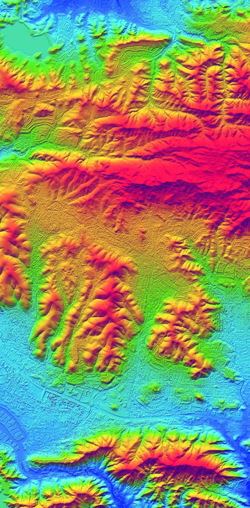
3 Gathered as part of the Southern California project, this image consists of a 3-meter grid GeoSAR DEM, colorized and merged with a 3-meter X-band magnitude image.


4 Gathered during GeoSAR engineering test flights, this image reveals a buried shipwreck in the bed of a dry lake, and shows the ability of GeoSAR P-Band data to penetrate dry soil The perfect example of the P-band operating at its full potential is a recent NGA project in Colombia, South America, where EarthData used GeoSAR to map the Cano-Limon oil pipeline, a project that covered nearly 94,000 square kilometers. Up until that time, even the best maps of this inaccessible jungle area contained voids and were outdated. While this was an ideal project for EarthData s second commercial GeoSAR project, there were a number of serious challenges. The dramatic variation in terrain elevation 5,000 meters from the coast to the Andes and the ruggedness of the terrain presented the first challenge. Careful flight planning ensured that the rugged terrain did not shadow the radar coverage of the ground. Additionally, because area maps were outdated, precise locations of international borders were unknown. Concern for creating an international incident manifested as extreme caution in maintaining a buffer zone to prevent inadvertent border crossing. Flight planners used NGA maps and ancillary data sources such as SRTM Flight line diagram of GLAD-P project. Note proximity to Venezuela. data to make certain flight crews acquired complete coverage with high-quality data. Difficult Project Conditions The installation of ground radar reflectors presented another challenge. Although plans indicated the placement of six reflectors to provide control, limited access and heightened security concerns resulted in the ground crews installing only three reflectors. Similarly, planners would have preferred three GPS base stations but ground crews could establish only two. One of the biggest challenges was the security of personnel, aircraft, and equipment. EarthData took extraordinary precautions, even hiring a local security


5 GeoSAR By The Numbers Most East Coast aerial data acquisition flights take place around mid-day in the winter when leafless trees and high sun angle provide the best conditions for sensors to collect ground feature data. Once the leaves emerge, acquiring data that accurately portrays the ground surface and elevations beneath the tree canopy becomes virtually impossible. This challenge is especially great in areas of the world where seasonal change has little impact on foliage canopy cover and where year-round cloud cover further obscures the ground. A new airborne mapping technology, GeoSAR, introduced at Washington s Reagan National Airport in the summer of 2001, has virtually eliminated this problem by using radar to gather both the elevations of the tops of the trees and the ground beneath them. GeoSAR is a dual band, interferometric synthetic aperture radar (SAR) system that was developed in cooperation with the California Institute of Technology Jet Propulsion Lab (JPL), the National Geospatial- Intelligence Agency (NGA), and EarthData. Work on the system began in 1995 under a contract from the Defense Advanced Research Projects Agency (DARPA). From the beginning, the project s primary goal was to develop GeoSAR into a fully operational system to be used in commercial applications, and this is where EarthData came in. Two of the end-products of this technology are Digital Elevation Models (DEMs) and orthorectified radar reflectance maps (also known as magnitude image maps), which provide information for applications like land use/land cover mapping and terrain analysis, among others. Topographic mapping with 3-meter contours is possible, and planimetric mapping can be done at 1:24,000 scale and larger. Military uses include mobilization planning, target detection and other specialized analyses. GeoSAR terrain models also can be used to orthorectify satellite imagery and supplement data collected by NASA s Shuttle Radar Topography Mission (SRTM), which has a ±10-meter vertical accuracy. 160 Square Kilometers per Minute Installed on EarthData s Gulfstream II jet aircraft, the GeoSAR system consists of radar transmitters, receivers, and recording equipment located in the cabin as well as antennas mounted outside the aircraft. The X-band system, with antenna pods located under each wing, emits 3-centimeter-wavelength pulses, which are reflected off the tops of vegetation (or any other first surface encountered). P-band antennas, located in wingtip pods, emit 86-centimeter-wavelength pulses capable of penetrating vegetation. Both X- and P-band pulses are reflected back to the antennas and then routed to a tape system in the cabin where the data is stored. As shown in the diagram, each antenna is capable of covering a swath on both sides of the aircraft, allowing simultaneous collection of X- and P-band data in each of two swaths, each approximately 10 kilometers width. Aerial operations overlap flight lines to provide coverage of the space between the swaths directly beneath the aircraft. As a result, some points on the ground are covered eight times. With the aircraft operating at over 30,000 feet above the ground, even minute movements of the wing-mounted antennas can greatly displace the swath on the ground. To compensate for this, the system designers developed a laser system, mounted in a pod beneath the fuselage of the aircraft, that precisely measures the position of each of the four antenna to an accuracy of ±0.3 millimeter. This data is recorded onboard the aircraft and subsequently incorporated when the radar data is processed. Data from the four antennas is processed using interferometry, which has been used in astronomy and for industrial applications for many years. In airborne remote sensing, SAR interferometry determines the topographic height of the observed surface by combining the phase history of the radar data collected by two separated SAR antennas looking at the same surface at the same time. Terrain canopy elevation data obtained by interferometric processing of GeoSAR s X-band data yields vertical accuracies of meters and planimetric accuracies of 1-3 meters. Ground elevation derived from the P-band yields vertical accuracies of 1-4 meters and planimetric accuracies of 3-5 meters, depending on the type of vegetation cover (height, moisture, density, etc.). Capable of acquiring data regardless of cloud cover, day or night, the system gathers data an at enormous rate. The two 10-kilometer-wide swaths are collected at a rate of 160 square kilometers per minute. The high-speed tape system in the aircraft stores data at the rate of 1gigabyte per second, which means a flight s worth of data can amount to one terabyte.
, are clearly visible in the P-band image (right) company for added protection.")


6 From the GLAD-P project, man-made features (outlined in red) such as buildings and fences, as well as small drainage networks (outlined in green) that are obscured by vegetation in the X-band image (left), are clearly visible in the P-band image (right) company for added protection. The company coordinated all flight activity with civilian and military agencies that controlled Colombian airspace. Leonard said the project would not have been successful without the cooperation and support of these groups. 22 Terabytes Collected After months of planning and preparation, project staff completed all the pre-deployment logistics, and the mission began. The crew of three pilots, one aircraft mechanic, three radar technicians, and a GPS operator arrived in Colombia ready for flight operations. At the end of the project, 478 tapes were needed to store the more than 22 terabytes of data collected and returning the nearly 3,000 pounds of tapes to the United States proved to be quite a challenge. To keep data from being lost or damaged during shipment, a courier periodically handcarried tapes back to EarthData s processing facility in Frederick, Maryland. This laborious procedure proved to be an effective way both to secure the data and to return it as soon as possible for processing. GPS data, on the other hand, was much easier to transport. After processing the GPS data in the field, the technician used a high-speed Internet connection at a nearby Colombian Navy facility to send the data back to Frederick each day. GeoSAR is just one of the mapping tools in EarthData s suite of airborne sensors, yet its capabilities for global mapping are revolutionary. Tropical jungle areas some with triple canopy layers can now be penetrated by GeoSAR technology, enabling mappers to view ground features such as trails, buildings, and other man-made structures heretofore hidden from view. With the successes of these first commercial projects, EarthData plans to use GeoSAR on other U.S. and international projects. Foreign national mapping organizations, as well as oil companies, mineral exploration companies, archeologists, and strategic partners and affiliates throughout the world have expressed interest in acquiring GeoSAR data. Even with these successful missions, EarthData continues to be cautious and conservative in mission planning and product development. Unlike lidar, which now has many equipment vendors and service providers, GeoSAR remains a one-of-akind system; its complexities and capabilities continue to be tested and developed as new applications arise and new users come forward. Left: Ground corner reflector for P-band imagery Right: Image of Thousand Oaks, California showing color DEM on right and magnitude image on left.
7
Configuration, Capabilities, Limitations, and Examples
 FUGRO EARTHDATA, Inc. Introduction to the New GeoSAR Interferometric Radar Sensor Bill Sharp GeoSAR Regional Director - Americas Becky Morton Regional Manager Configuration, Capabilities, Limitations,
Active and Passive Microwave Remote Sensing
 Active and Passive Microwave Remote Sensing Passive remote sensing system record EMR that was reflected (e.g., blue, green, red, and near IR) or emitted (e.g., thermal IR) from the surface of the Earth.
Active and Passive Microwave Remote Sensing
 Active and Passive Microwave Remote Sensing Passive remote sensing system record EMR that was reflected (e.g., blue, green, red, and near IR) or emitted (e.g., thermal IR) from the surface of the Earth.
GeoSAR P-band and X-band Performance In Southern California and Colombia, South America
 GeoSAR P-band and X-band Performance In Southern California and Colombia, South America ISPRS International WG 1/2 Workshop 2005 James J Reis, EarthData Technologies Dr. Scott Hensley, Jet Propulsion Laboratory
RADAR (RAdio Detection And Ranging)
") RADAR (RAdio Detection And Ranging) CLASSIFICATION OF NONPHOTOGRAPHIC REMOTE SENSORS PASSIVE ACTIVE DIGITAL CAMERA THERMAL (e.g. TIMS) VIDEO CAMERA MULTI- SPECTRAL SCANNERS VISIBLE & NIR MICROWAVE Real
RADAR (RAdio Detection And Ranging) CLASSIFICATION OF NONPHOTOGRAPHIC REMOTE SENSORS PASSIVE ACTIVE DIGITAL CAMERA THERMAL (e.g. TIMS) VIDEO CAMERA MULTI- SPECTRAL SCANNERS VISIBLE & NIR MICROWAVE Real
MODULE 7 LECTURE NOTES 3 SHUTTLE RADAR TOPOGRAPHIC MISSION DATA
 MODULE 7 LECTURE NOTES 3 SHUTTLE RADAR TOPOGRAPHIC MISSION DATA 1. Introduction Availability of a reasonably accurate elevation information for many parts of the world was once very much limited. Dense
SAR Imagery: Airborne or Spaceborne? Presenter: M. Lorraine Tighe PhD
 SAR Imagery: Airborne or Spaceborne? Presenter: M. Lorraine Tighe PhD Introduction The geospatial community has seen a plethora of spaceborne SAR imagery systems where there are now extensive archives
ACTIVE SENSORS RADAR
 ACTIVE SENSORS RADAR RADAR LiDAR: Light Detection And Ranging RADAR: RAdio Detection And Ranging SONAR: SOund Navigation And Ranging Used to image the ocean floor (produce bathymetic maps) and detect objects
THE NASA/JPL AIRBORNE SYNTHETIC APERTURE RADAR SYSTEM. Yunling Lou, Yunjin Kim, and Jakob van Zyl
 THE NASA/JPL AIRBORNE SYNTHETIC APERTURE RADAR SYSTEM Yunling Lou, Yunjin Kim, and Jakob van Zyl Jet Propulsion Laboratory California Institute of Technology 4800 Oak Grove Drive, MS 300-243 Pasadena,
NEXTMAP. P-Band. Airborne Radar Imaging Technology. Key Benefits & Features INTERMAP.COM. Answers Now
 INTERMAP.COM Answers Now NEXTMAP P-Band Airborne Radar Imaging Technology Intermap is proud to announce the latest advancement of their Synthetic Aperture Radar (SAR) imaging technology. Leveraging over
THREE-DIMENSIONAL MAPPING USING BOTH AIRBORNE AND SPACEBORNE IFSAR TECHNOLOGIES ABSTRACT INTRODUCTION
 THREE-DIMENSIONAL MAPPING USING BOTH AIRBORNE AND SPACEBORNE IFSAR TECHNOLOGIES Trina Kuuskivi Manager of Value Added Products and Services, Intermap Technologies Corp. 2 Gurdwara Rd, Suite 200, Ottawa,
Microwave Remote Sensing (1)
") Microwave Remote Sensing (1) Microwave sensing encompasses both active and passive forms of remote sensing. The microwave portion of the spectrum covers the range from approximately 1cm to 1m in wavelength.
Microwave Remote Sensing (1) Microwave sensing encompasses both active and passive forms of remote sensing. The microwave portion of the spectrum covers the range from approximately 1cm to 1m in wavelength.
ANALYSIS OF SRTM HEIGHT MODELS
 ANALYSIS OF SRTM HEIGHT MODELS Sefercik, U. *, Jacobsen, K.** * Karaelmas University, Zonguldak, Turkey, ugsefercik@hotmail.com **Institute of Photogrammetry and GeoInformation, University of Hannover,
Principles of Remote Sensing. Shuttle Radar Topography Mission S R T M. Michiel Damen. Dept. Earth Systems Analysis
 Principles of Remote Sensing Shuttle Radar Topography Mission S R T M Michiel Damen Dept. Earth Systems Analysis Contents Present problems with DEMs Advantage of SRTM Cell size Mission and system Radar
Introduction Active microwave Radar
 RADAR Imaging Introduction 2 Introduction Active microwave Radar Passive remote sensing systems record electromagnetic energy that was reflected or emitted from the surface of the Earth. There are also
9/13/2011. Training Course Remote Sensing Basic Theory & Image Processing Methods September 2011
 Training Course Remote Sensing Basic Theory & Image Processing Methods 19 23 September 2011 DIGITAL TERRAIN MODELS Introduction Michiel Damen (April 2011) damen@itc.nl 1 Digital Elevation and Terrain Models
Sources of Geographic Information
 Sources of Geographic Information Data properties: Spatial data, i.e. data that are associated with geographic locations Data format: digital (analog data for traditional paper maps) Data Inputs: sampled
Synthetic Aperture Radar
 Synthetic Aperture Radar Picture 1: Radar silhouette of a ship, produced with the ISAR-Processor of the Ocean Master A Synthetic Aperture Radar (SAR), or SAR, is a coherent mostly airborne or spaceborne
EarthData International
 EarthData International The aeroplane has unveiled for us the true face of the earth, wrote French aviator Antoine de Saint-Exupéry in his book Wind, Sand, and Stars, published in 1939. Decades later,
Synthetic aperture RADAR (SAR) principles/instruments October 31, 2018
 principles/instruments October 31, 2018") GEOL 1460/2461 Ramsey Introduction to Remote Sensing Fall, 2018 Synthetic aperture RADAR (SAR) principles/instruments October 31, 2018 I. Reminder: Upcoming Dates lab #2 reports due by the start of next
GEOL 1460/2461 Ramsey Introduction to Remote Sensing Fall, 2018 Synthetic aperture RADAR (SAR) principles/instruments October 31, 2018 I. Reminder: Upcoming Dates lab #2 reports due by the start of next
Module 3 Introduction to GIS. Lecture 8 GIS data acquisition
 Module 3 Introduction to GIS Lecture 8 GIS data acquisition GIS workflow Data acquisition (geospatial data input) GPS Remote sensing (satellites, UAV s) LiDAR Digitized maps Attribute Data Management Data
Windstorm Simulation & Modeling Project
 Windstorm Simulation & Modeling Project Manatee County Digital Elevation Models Preliminary Report Prepared for: The Manatee County Public Safety Department 1112 Manatee Avenue West, Suite 525 Bradenton,
Microwave Remote Sensing
 Provide copy on a CD of the UCAR multi-media tutorial to all in class. Assign Ch-7 and Ch-9 (for two weeks) as reading material for this class. HW#4 (Due in two weeks) Problems 1,2,3 and 4 (Chapter 7)
The studies began when the Tiros satellites (1960) provided man s first synoptic view of the Earth s weather systems.
 provided man s first synoptic view of the Earth s weather systems.") Remote sensing of the Earth from orbital altitudes was recognized in the mid-1960 s as a potential technique for obtaining information important for the effective use and conservation of natural resources.
Remote sensing of the Earth from orbital altitudes was recognized in the mid-1960 s as a potential technique for obtaining information important for the effective use and conservation of natural resources.
An Introduction to Geomatics. Prepared by: Dr. Maher A. El-Hallaq خاص بطلبة مساق مقدمة في علم. Associate Professor of Surveying IUG
 An Introduction to Geomatics خاص بطلبة مساق مقدمة في علم الجيوماتكس Prepared by: Dr. Maher A. El-Hallaq Associate Professor of Surveying IUG 1 Airborne Imagery Dr. Maher A. El-Hallaq Associate Professor
Passive Microwave Sensors LIDAR Remote Sensing Laser Altimetry. 28 April 2003
 Passive Microwave Sensors LIDAR Remote Sensing Laser Altimetry 28 April 2003 Outline Passive Microwave Radiometry Rayleigh-Jeans approximation Brightness temperature Emissivity and dielectric constant
Flood modelling and management. Glasgow University. 8 September Paul Shaw - GeoVision
 Flood modelling and management Glasgow University 8 September 2004 Paul Shaw - GeoVision How important are heights in flood modelling? Comparison of data collection technologies GPS - Global Positioning
Introduction to Radar
 National Aeronautics and Space Administration ARSET Applied Remote Sensing Training http://arset.gsfc.nasa.gov @NASAARSET Introduction to Radar Jul. 16, 2016 www.nasa.gov Objective The objective of this
GEO 428: DEMs from GPS, Imagery, & Lidar Tuesday, September 11
 GEO 428: DEMs from GPS, Imagery, & Lidar Tuesday, September 11 Global Positioning Systems GPS is a technology that provides Location coordinates Elevation For any location with a decent view of the sky
Remote Sensing. Ch. 3 Microwaves (Part 1 of 2)
") Remote Sensing Ch. 3 Microwaves (Part 1 of 2) 3.1 Introduction 3.2 Radar Basics 3.3 Viewing Geometry and Spatial Resolution 3.4 Radar Image Distortions 3.1 Introduction Microwave (1cm to 1m in wavelength)
Remote Sensing Ch. 3 Microwaves (Part 1 of 2) 3.1 Introduction 3.2 Radar Basics 3.3 Viewing Geometry and Spatial Resolution 3.4 Radar Image Distortions 3.1 Introduction Microwave (1cm to 1m in wavelength)
MSB Imagery Program FAQ v1
 MSB Imagery Program FAQ v1 (F)requently (A)sked (Q)uestions 9/22/2016 This document is intended to answer commonly asked questions related to the MSB Recurring Aerial Imagery Program. Table of Contents
AIRPORT MAPPING JUNE 2016 EXPLORING UAS EFFECTIVENESS GEOSPATIAL SLAM TECHNOLOGY FEMA S ROMANCE WITH LIDAR VOLUME 6 ISSUE 4
 VOLUME 6 ISSUE 4 JUNE 2016 AIRPORT MAPPING 18 EXPLORING UAS EFFECTIVENESS 29 GEOSPATIAL SLAM TECHNOLOGY 36 FEMA S ROMANCE WITH LIDAR Nearly 2,000 U.S. landfill facilities stand to gain from cost-effective
Introduction of Satellite Remote Sensing
 Introduction of Satellite Remote Sensing Spatial Resolution (Pixel size) Spectral Resolution (Bands) Resolutions of Remote Sensing 1. Spatial (what area and how detailed) 2. Spectral (what colors bands)
FLIGHT SUMMARY REPORT
 FLIGHT SUMMARY REPORT Flight Number: 97-011 Calendar/Julian Date: 23 October 1996 297 Sensor Package: Area(s) Covered: Wild-Heerbrugg RC-10 Airborne Visible and Infrared Imaging Spectrometer (AVIRIS) Southern
Monitoring the Earth Surface from space
 Monitoring the Earth Surface from space Picture of the surface from optical Imagery, i.e. obtained by telescopes or cameras operating in visual bandwith. Shape of the surface from radar imagery Surface
ASSESSMENT OF SRTM, ACE2 AND ASTER-GDEM USING RTK-GPS
 ASSESSMENT OF SRTM, ACE2 AND ASTER-GDEM USING RTK-GPS Hsing-Chung Chang, Xiaojing Li, Linlin Ge School of Surveying and Spatial Information Systems The University of New South Wales, Sydney, NSW 2052,
Acquisition of Aerial Photographs and/or Satellite Imagery
 Acquisition of Aerial Photographs and/or Satellite Imagery Acquisition of Aerial Photographs and/or Imagery From time to time there is considerable interest in the purchase of special-purpose photography
Remote Sensing for Rangeland Applications
 Remote Sensing for Rangeland Applications Jay Angerer Ecological Training June 16, 2012 Remote Sensing The term "remote sensing," first used in the United States in the 1950s by Ms. Evelyn Pruitt of the
Review. Guoqing Sun Department of Geography, University of Maryland ABrief
 Review Guoqing Sun Department of Geography, University of Maryland gsun@glue.umd.edu ABrief Introduction Scattering Mechanisms and Radar Image Characteristics Data Availability Example of Applications
Radio Mobile. Software for Wireless Systems Planning
 Latin American Networking School (EsLaRed) Universidad de Los Andes Merida Venezuela Javier Triviño and E.Pietrosemoli Radio Mobile Software for Wireless Systems Planning About Radio Mobile It is a tool
Electronic Warfare Training in the Pacific Northwest
 Electronic Warfare Training in the Pacific Northwest Mission of the U.S. Navy To maintain, train and equip combat-ready naval forces capable of winning wars, deterring aggression and maintaining freedom
Air-to-Ground Data Link: Proof of Concept Test Report. CoE
 Scope of the Report Air-to-Ground Data Link: Proof of Concept Test Report CoE-17-003.1 The Center of Excellence for Advanced Technology Aerial Firefighting (CoE) is charged with researching, testing, and
PHOTOGRAMMETRIC RESECTION DIFFERENCES BASED ON LABORATORY vs. OPERATIONAL CALIBRATIONS
 PHOTOGRAMMETRIC RESECTION DIFFERENCES BASED ON LABORATORY vs. OPERATIONAL CALIBRATIONS Dean C. MERCHANT Topo Photo Inc. Columbus, Ohio USA merchant.2@osu.edu KEY WORDS: Photogrammetry, Calibration, GPS,
INTEGRATIVE MIGRATORY BIRD MANAGEMENT ON MILITARY BASES: THE ROLE OF RADAR ORNITHOLOGY
 INTEGRATIVE MIGRATORY BIRD MANAGEMENT ON MILITARY BASES: THE ROLE OF RADAR ORNITHOLOGY Sidney A. Gauthreaux, Jr. and Carroll G. Belser Department of Biological Sciences Clemson University Clemson, SC 29634-0314
The Shuttle Radar Topography Mission: A Global DEM
 The Shuttle Radar Topography Mission: A Global DEM Tom G. Farr, Mike Kobrick Jet Propulsion Laboratory California Institute of Technology Pasadena, CAUSA Digital topographic data are critical for a variety
Govt. Engineering College Jhalawar Model Question Paper Subject- Remote Sensing & GIS
 Govt. Engineering College Jhalawar Model Question Paper Subject- Remote Sensing & GIS Time: Max. Marks: Q1. What is remote Sensing? Explain the basic components of a Remote Sensing system. Q2. What is
The SARTOM Project; Tomography for enhanced target detection for foliage penetrating airborne SAR (First-Year Results)
") The SARTOM Project; Tomography for enhanced target detection for foliage penetrating airborne SAR (First-Year Results) Ralf Horn 1, Jens Fischer 1, Armando Marino 2, Matteo Nannini 1, Kim Partington 3,
The SARTOM Project; Tomography for enhanced target detection for foliage penetrating airborne SAR (First-Year Results) Ralf Horn 1, Jens Fischer 1, Armando Marino 2, Matteo Nannini 1, Kim Partington 3,
(Presented by Jeppesen) Summary
 Summary") International Civil Aviation Organization SAM/IG/6-IP/06 South American Regional Office 24/09/10 Sixth Workshop/Meeting of the SAM Implementation Group (SAM/IG/6) - Regional Project RLA/06/901 Lima, Peru,
International Civil Aviation Organization SAM/IG/6-IP/06 South American Regional Office 24/09/10 Sixth Workshop/Meeting of the SAM Implementation Group (SAM/IG/6) - Regional Project RLA/06/901 Lima, Peru,
Radar Imagery for Forest Cover Mapping
 Purdue University Purdue e-pubs LARS Symposia Laboratory for Applications of Remote Sensing 1-1-1981 Radar magery for Forest Cover Mapping D. J. Knowlton R. M. Hoffer Follow this and additional works at:
Improving Airport Planning & Development and Operations & Maintenance via Skyline 3D Software
 Improving Airport Planning & Development and Operations & Maintenance via Skyline 3D Software By David Tamir, February 2014 Skyline Software Systems has pioneered web-enabled 3D information mapping and
Aerial Photo Interpretation
 Aerial Photo Interpretation Aerial Photo Interpretation To date, course has focused on skills of photogrammetry Scale Distance Direction Area Height There s another side to Aerial Photography: Interpretation
Orthoimagery Standards. Chatham County, Georgia. Jason Lee and Noel Perkins
 1 Orthoimagery Standards Chatham County, Georgia Jason Lee and Noel Perkins 2 Table of Contents Introduction... 1 Objective... 1.1 Data Description... 2 Spatial and Temporal Environments... 3 Spatial Extent
TEMPORAL ANALYSIS OF MULTI EPOCH LANDSAT GEOCOVER IMAGES IN ZONGULDAK TESTFIELD
 TEMPORAL ANALYSIS OF MULTI EPOCH LANDSAT GEOCOVER IMAGES IN ZONGULDAK TESTFIELD Şahin, H. a*, Oruç, M. a, Büyüksalih, G. a a Zonguldak Karaelmas University, Zonguldak, Turkey - (sahin@karaelmas.edu.tr,
MPA Baseline Program. Annual Progress Report
 MPA Baseline Program Annual Progress Report Principal Investigators please use this form to submit your MPA Baseline Program project annual report, including an update on activities completed over the
Project Planning and Cost Estimating
 CHAPTER 17 Project Planning and Cost Estimating 17.1 INTRODUCTION Previous chapters have outlined and detailed technical aspects of photogrammetry. The basic tasks and equipment required to create various
3/31/03. ESM 266: Introduction 1. Observations from space. Remote Sensing: The Major Source for Large-Scale Environmental Information
 Remote Sensing: The Major Source for Large-Scale Environmental Information Jeff Dozier Observations from space Sun-synchronous polar orbits Global coverage, fixed crossing, repeat sampling Typical altitude
to Geospatial Technologies
 What s in a Pixel? A Primer for Remote Sensing What s in a Pixel Development UNH Cooperative Extension Geospatial Technologies Training Center Shane Bradt UConn Cooperative Extension Geospatial Technology
Acquisition of Aerial Photographs and/or Imagery
 Acquisition of Aerial Photographs and/or Imagery Acquisition of Aerial Photographs and/or Imagery From time to time there is considerable interest in the purchase of special-purpose photography contracted
The studies began when the Tiros satellites (1960) provided man s first synoptic view of the Earth s weather systems.
 provided man s first synoptic view of the Earth s weather systems.") Remote sensing of the Earth from orbital altitudes was recognized in the mid-1960 s as a potential technique for obtaining information important for the effective use and conservation of natural resources.
Remote sensing of the Earth from orbital altitudes was recognized in the mid-1960 s as a potential technique for obtaining information important for the effective use and conservation of natural resources.
DRAPP Product QAQC Participating Partner Process Guidelines Steve Ashbee ASPRS Certified Photogrammetrist PMI Project Management Professional Sanborn
 DRAPP Product QAQC Participating Partner Process Guidelines Steve Ashbee ASPRS Certified Photogrammetrist PMI Project Management Professional Sanborn Program Manager Area naming and other general feedback
RECOMMENDATION ITU-R SA.1624 *
 Rec. ITU-R SA.1624 1 RECOMMENDATION ITU-R SA.1624 * Sharing between the Earth exploration-satellite (passive) and airborne altimeters in the aeronautical radionavigation service in the band 4 200-4 400
Detecting and Mapping Invasive Phragmites australis in the Coastal Great Lakes with ALOS PALSAR Imagery
 Detecting and Mapping Invasive Phragmites australis in the Coastal Great Lakes with ALOS PALSAR Imagery Brian Huberty U.S Fish & Wildlife Service Region 3 Ecological Services Laura L. Bourgeau-Chavez,
Specificities of Near Nadir Ka-band Interferometric SAR Imagery
 Specificities of Near Nadir Ka-band Interferometric SAR Imagery Roger Fjørtoft, Alain Mallet, Nadine Pourthie, Jean-Marc Gaudin, Christine Lion Centre National d Etudes Spatiales (CNES), France Fifamé
HARRIS GEOSPATIAL MARKETPLACE. HarrisGeospatial.com
 HARRIS GEOSPATIAL MARKETPLACE HarrisGeospatial.com Satellite image of Washington, D.C. Image courtesy of DigitalGlobe GET IT ALL IN ONE PLACE Data for Any Project Map Products Vis/Sim Products Geospatial
Ge111A Remote Sensing and GIS Lecture
 Ge111A Remote Sensing and GIS Lecture Remote Sensing - many different geophysical data sets. We concentrate on the following: Imagery (optical and radar) Topography Geographical Information Systems (GIS)
RADAR REMOTE SENSING
 RADAR REMOTE SENSING Jan G.P.W. Clevers & Steven M. de Jong Chapter 8 of L&K 1 Wave theory for the EMS: Section 1.2 of L&K E = electrical field M = magnetic field c = speed of light : propagation direction
BYU SAR: A LOW COST COMPACT SYNTHETIC APERTURE RADAR
 BYU SAR: A LOW COST COMPACT SYNTHETIC APERTURE RADAR David G. Long, Bryan Jarrett, David V. Arnold, Jorge Cano ABSTRACT Synthetic Aperture Radar (SAR) systems are typically very complex and expensive.
NAVIGATION AND REMOTE SENSING PAYLOADS AND METHODS OF THE SARVANT UNMANNED AERIAL SYSTEM
 NAVIGATION AND REMOTE SENSING PAYLOADS AND METHODS OF THE SARVANT UNMANNED AERIAL SYSTEM P. Molina, P. Fortuny, I. Colomina Institute of Geomatics -- Castelldefels (ES) M. Remy, K.A.C. Macedo, Y.R.C. Zúnigo,
DEMS BASED ON SPACE IMAGES VERSUS SRTM HEIGHT MODELS. Karsten Jacobsen. University of Hannover, Germany
 DEMS BASED ON SPACE IMAGES VERSUS SRTM HEIGHT MODELS Karsten Jacobsen University of Hannover, Germany jacobsen@ipi.uni-hannover.de Key words: DEM, space images, SRTM InSAR, quality assessment ABSTRACT
RADAR INTERFEROMETRY FOR SAFE COAL MINING IN CHINA
 RADAR INTERFEROMETRY FOR SAFE COAL MINING IN CHINA L. Ge a, H.-C. Chang a, A. H. Ng b and C. Rizos a Cooperative Research Centre for Spatial Information School of Surveying & Spatial Information Systems,
NON-PHOTOGRAPHIC SYSTEMS: Multispectral Scanners Medium and coarse resolution sensor comparisons: Landsat, SPOT, AVHRR and MODIS
 NON-PHOTOGRAPHIC SYSTEMS: Multispectral Scanners Medium and coarse resolution sensor comparisons: Landsat, SPOT, AVHRR and MODIS CLASSIFICATION OF NONPHOTOGRAPHIC REMOTE SENSORS PASSIVE ACTIVE DIGITAL
Sea Surface Backscatter Distortions of Scanning Radar Altimeter Ocean Wave Measurements
 Sea Surface Backscatter Distortions of Scanning Radar Altimeter Ocean Wave Measurements Edward J. Walsh and C. Wayne Wright NASA Goddard Space Flight Center Wallops Flight Facility Wallops Island, VA 23337
EARLY DEVELOPMENT IN SYNTHETIC APERTURE LIDAR SENSING FOR ON-DEMAND HIGH RESOLUTION IMAGING
 EARLY DEVELOPMENT IN SYNTHETIC APERTURE LIDAR SENSING FOR ON-DEMAND HIGH RESOLUTION IMAGING ICSO 2012 Ajaccio, Corse, France, October 11th, 2012 Alain Bergeron, Simon Turbide, Marc Terroux, Bernd Harnisch*,
MAPPING DAMAGES CAUSED BY THE OCTOBER 2003 WILDFIRES IN CALIFORNIA
 MAPPING DAMAGES CAUSED BY THE OCTOBER 2003 WILDFIRES IN CALIFORNIA Louis Demargne & Mitch Jordan EarthData International 7320 Executive Way, Frederick, MD 21702 ABSTRACT EarthData, in coordination with
Accuracy assessment of a digital height model derived from airborne synthetic aperture radar measurements
 Kleusberg, Klaedtke 139 Accuracy assessment of a digital height model derived from airborne synthetic aperture radar measurements ALFRED KLEUS BERG and HANS-GEORG KLAEDTKE, S tuttgart ABSTRACT A digital
Exploring the Earth with Remote Sensing: Tucson
 Exploring the Earth with Remote Sensing: Tucson Project ASTRO Chile March 2006 1. Introduction In this laboratory you will explore Tucson and its surroundings with remote sensing. Remote sensing is the
Synthetic Aperture Radar. Hugh Griffiths THALES/Royal Academy of Engineering Chair of RF Sensors University College London
 Synthetic Aperture Radar Hugh Griffiths THALES/Royal Academy of Engineering Chair of RF Sensors University College London CEOI Training Workshop Designing and Delivering and Instrument Concept 15 March
SECOND OPEN SKIES REVIEW CONFERENCE (OSRC) 2010
 2010") OSCC.RC/40/10 9 June 2010 Open Skies Consultative Commission ENGLISH only US Chair of the OSCC Review Conference SECOND OPEN SKIES REVIEW CONFERENCE (OSRC) 2010 7 to 9 June 2010 Working Session 2 Exploring
OSCC.RC/40/10 9 June 2010 Open Skies Consultative Commission ENGLISH only US Chair of the OSCC Review Conference SECOND OPEN SKIES REVIEW CONFERENCE (OSRC) 2010 7 to 9 June 2010 Working Session 2 Exploring
Helicopter Aerial Laser Ranging
 Helicopter Aerial Laser Ranging Håkan Sterner TopEye AB P.O.Box 1017, SE-551 11 Jönköping, Sweden 1 Introduction Measuring distances with light has been used for terrestrial surveys since the fifties.
21 st Century Skills. Describe how satellite data is transmitted from space to Earth,
 Level of Difficulty: 4 Grade Range: 9-12 Activity Time: 45-60 min Business Category: IT Topic: Information and Communication OVERVIEW Information and Communication In this lesson, students will explore
Remote Sensing of the Environment
 Remote Sensing of the Environment An Earth Resource Perspective John R. Jensen University of South Carolina Prentice Hall Upper Saddle River, New Jersey 07458 Brief Contents 1 Remote Sensing of the Environment
10 Radar Imaging Radar Imaging
 10 Radar Imaging Active sensors provide their own source of energy to illuminate the target. Active sensors are generally divided into two distinct categories: imaging and non-imaging. The most common
UNERSITY OF NAIROBI UNIT: PRICIPLES AND APPLICATIONS OF REMOTE SENSING AND APLLIED CLIMATOLOGY
 UNERSITY OF NAIROBI DEPARTMENT OF METEOROLOGY UNIT: PRICIPLES AND APPLICATIONS OF REMOTE SENSING AND APLLIED CLIMATOLOGY COURSE CODE: SMR 308 GROUP TWO: SENSORS MEMBERS OF GROUP TWO 1. MUTISYA J.M I10/2784/2006
A map says to you, 'Read me carefully, follow me closely, doubt me not.' It says, 'I am the Earth in the palm of your hand. Without me, you are alone
 A map says to you, 'Read me carefully, follow me closely, doubt me not.' It says, 'I am the Earth in the palm of your hand. Without me, you are alone and lost. Beryl Markham (West With the Night, 1946
TerraSAR-X Applications Guide
 TerraSAR-X Applications Guide Extract: Change Detection and Monitoring: Geospatial / Image Intelligence April 2015 Airbus Defence and Space Geo-Intelligence Programme Line Change Detection and Monitoring:
MODULE 9 LECTURE NOTES 2 ACTIVE MICROWAVE REMOTE SENSING
 MODULE 9 LECTURE NOTES 2 ACTIVE MICROWAVE REMOTE SENSING 1. Introduction Satellite sensors are capable of actively emitting microwaves towards the earth s surface. An active microwave system transmits
A Report on the Ground Penetrating Radar Survey 205 Little Plains Road Southampton, NY
 A Report on the Ground Penetrating Radar Survey 205 Little Plains Road Southampton, NY November 18, 2016 Conducted by Robert W. Perry TOPOGRAPHIX, LLC Hudson, NH Requested by Southampton Town Historical
The Normal Baseline. Dick Gent Law of the Sea Division UK Hydrographic Office
 The Normal Baseline Dick Gent Law of the Sea Division UK Hydrographic Office 2 The normal baseline for measuring the breadth of the territorial sea is the low water line along the coast as marked on large
746A27 Remote Sensing and GIS
 746A27 Remote Sensing and GIS Lecture 1 Concepts of remote sensing and Basic principle of Photogrammetry Chandan Roy Guest Lecturer Department of Computer and Information Science Linköping University What
WHAT S INSIDE THE BUILDING?
 WHAT S INSIDE THE BUILDING? Patrik Dammert, Hans Hellsten, Anders Åhlander, Anders Nilsson, Magnus Gisselfält, Niklas Eriksson Aerospace Technology Congress 2016 Flygteknik 2016 This document and the information
Combining Technologies: LiDaR, High Resolution Digital Images, Infrared Thermography and Geographic Information Systems
 : LiDaR, High Resolution Digital Images, Infrared Thermography and Geographic Information Systems Presented by: Eldris Ferrer, Ms E, GIS Analyst and Remote Sensing Specialist, CSA Group Alexis Ocasio,
2012 PRODUCT INFORMATION SHEET. EagleEye 350 Multi-Role, Special Missions Aerial Surveillance Platform
 2012 PRODUCT INFORMATION SHEET EagleEye 350 Multi-Role, Special Missions Aerial Surveillance Platform The EagleEye 350 is a unique, highly-capable Airborne Multi-Role, Multi-Sensor, Special Missions -
Radar Imaging Wavelengths
 A Basic Introduction to Radar Remote Sensing ~~~~~~~~~~ Rev. Ronald J. Wasowski, C.S.C. Associate Professor of Environmental Science University of Portland Portland, Oregon 3 November 2015 Radar Imaging
UAV-based L-band SAR with precision flight path control
 UAV-based L-band SAR with precision flight path control Soren N. Madsen, Scott Hensley, Kevin Wheeler, Greg Sadowy, Tim Miller, Ron Muellerschoen, Yunling Lou, and Paul Rosen Jet Propulsion Laboratory,
Stratollites set to provide persistent-image capability
 Stratollites set to provide persistent-image capability [Content preview Subscribe to Jane s Intelligence Review for full article] Persistent remote imaging of a target area is a capability previously
National Height Modernization: Cost comparison of conducting a vertical survey by leveling versus by GPS in western North Carolina
 Introduction: National Height Modernization: Cost comparison of conducting a vertical survey by leveling versus by GPS in western North Carolina The North Carolina Geodetic Survey (NCGS) conducted a National
Geo/SAT 2 INTRODUCTION TO REMOTE SENSING
 Geo/SAT 2 INTRODUCTION TO REMOTE SENSING Paul R. Baumann, Professor Emeritus State University of New York College at Oneonta Oneonta, New York 13820 USA COPYRIGHT 2008 Paul R. Baumann Introduction Remote
Customer Showcase > Defense and Intelligence
 Customer Showcase Skyline TerraExplorer is a critical visualization technology broadly deployed in defense and intelligence, public safety and security, 3D geoportals, and urban planning markets. It fuses
Development of the Technology of Utilization of Airborne Synthetic Aperture Radar (SAR)
") Development of the Technology of Utilization of Airborne Synthetic Aperture Radar (SAR) Mamoru Koarai, Kouichi Moteki, Nobuyuki Watanabe, Takaki Okatani,Youko Yamada and Kaoru Matsuo Geographical Survey
Development of the Technology of Utilization of Airborne Synthetic Aperture Radar (SAR) Mamoru Koarai, Kouichi Moteki, Nobuyuki Watanabe, Takaki Okatani,Youko Yamada and Kaoru Matsuo Geographical Survey
Land Navigation / Map Reading
 Land Navigation / Map Reading What is the Field Manual for map reading and land navigation? FM 3-25.26 What are the basic colors of a map, and what does each color represent? Black - Indicates cultural