IIT Illinois Institute of Technology Lew Collens, President
|
|
|
- Sandra Osborne
- 5 years ago
- Views:
Transcription
1

2

3


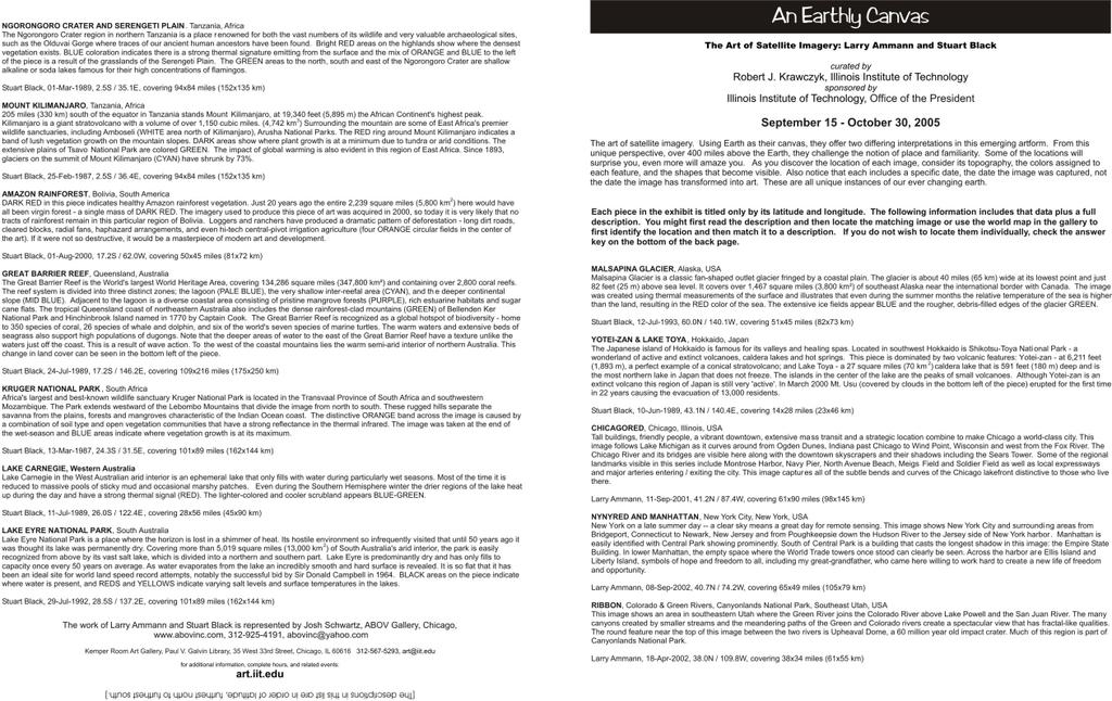
4 IIT Illinois Institute of Technology Lew Collens, President IIT Art Board Judith Carr, Chair Executive Assistant to the President Office of the President Catherine Bruck University Archivist Paul V. Galvin Library Justine Jentes Director of Marketing Mies Society Nora Kyger Associate Director Institute of Design Chuck Owen Research Professor Institute of Design Christopher Stewart Acting Dean Paul V. Galvin Library Gallery Staff Robert J. Krawczyk Gallery Director Assistant Professor, College of Architecture Mindy Sherman Exhibition Coordinator College of Science and Letters Kemper Room Art Gallery Paul V. Galvin Library exhibition hours: Monday - Thursday: 12 noon - 10 pm Friday: 12 noon - 5 pm Saturday: 8:30 am - 5 pm Sunday: 2-10 pm Kemper Room Art Gallery, Paul V. Galvin Library, 35 West 33rd Street, Chicago, IL , art@iit.edu for additional information, complete hours, and related events: art.iit.edu The Art of Satellite Imagery: Larry Ammann and Stuart Black IIT ILLINOIS INSTITUTE OF TECHNOLOGY
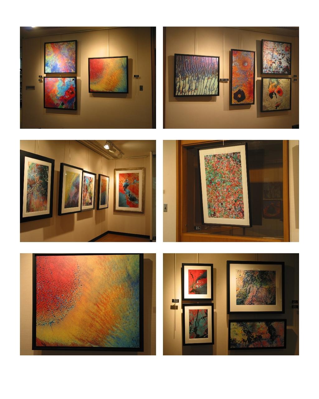
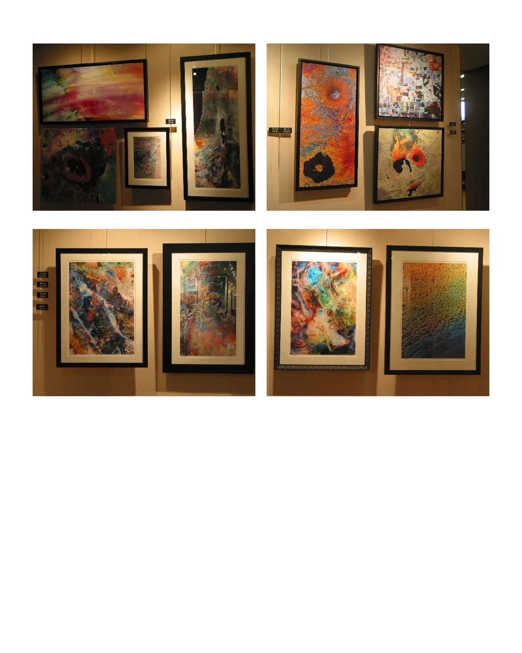
5 curated by Robert J. Krawczyk, Illinois Institute of Technology sponsored by Illinois Institute of Technology, Office of the President September 15 - October 30, 2005 The art of satellite imagery. Using Earth as their canvas, they offer two differing interpretations in this emerging artform. From this unique perspective, over 400 miles above the Earth, they challenge the notion of place and familiarity. Some of the locations will surprise you, even more will amaze you. Their art is based on the science of remote sensing. This is the name given to a host of activities designed to gather data and information about the Earth's surface without actually being in contact with it. This is done by using space-borne sensors to measure energy reflected or emitted by surface features. The data collected is then processed into imagery from which information can be visually interpreted or derived using complex algorithms. Part science, part art, remote sensing has transformed how we view our planet and the way we conduct our daily lives. Applications are as varied as they are numerous; from mapping every facet of life on Earth, to real-time pollution monitoring, and forecasting the weather. This exhibit covers a diverse selection of the earth; urban areas, deserts, rainforests, mountains, rivers, and oceans. Discover how these artists use color to highlight the variety of topographic features observed. Larry's approach and interpretation is to reveal the unique compositions, shapes, and colors of the Earth that are hidden in the data while still retaining recognizable topographic features. Stuart using similar data creates images that are more in an abstract or impressionist style. Many of his images obscure the actual topography to highlight prominent features. Larry Ammann Stuart Black Artist Statement: I think that people have always been fascinated by views of our planet from vantage points other than our own eyes. Artists and photographers have trekked to remote lands or ascended to great heights by balloon, by airplane, and by spacecraft to show our planet as we cannot see it from the surface. My goal is to use remote sensing satellite data to show our planet in ways that our eyes are incapable of seeing, and as a result, to reveal the abstract compositions, shapes, and colors of the Earth that are hidden in this data. I start by searching for an area that looks interesting from the satellite's perspective 420 miles above the surface. I then try to create an image from the raw data that displays a unique combination of composition, shape, and color to show the area in ways that cannot be seen visually but which reveals its inherent beauty. My goal is to create an image that is art first and a place second. This is accomplished by making use of my image processing programs to first separate different features numerically and then to map these separate features to different colors. Every type of material - different rock types, different minerals, vegetation and crops, buildings and other artifacts of civilization - all reflect electromagnetic energy differently. Most of these differences occur in the infra-red portion of the spectrum. The colors that result from my image processing are not real in the sense that they are not colors that we can see with our eyes. But they are not false colors since different colors correspond to different features on the surface. The result is a unique view of an area that can be seen as a 4-dimensional image. Viewed from afar, you see the basic shapes and colors, but as you move closer, you begin to see details and textures that get finer and finer the closer you come to the print. Larry Ammann is a Professor of Statistics and Associate Department Head of Mathematical Sciences at the University of Texas at Dallas. He received his PhD in Statistics from the Florida State University and is currently on leave at the Southwestern Medical Center's Advanced Imaging Research Center at the University of Texas. Artist Statement: As if by placing his palette high in orbit above the planet, Stuart's Nature's Canvas works are created from digital data acquired by the Landsat satellites, observing the Earth from 705 km away. These satellites measure surface radiation across seven bands of the electromagnetic spectrum - three in the visible portion (the colors we can see) and four in the infrared region (indicators of plant growth, surface moisture, underlying geology and temperature). At times during the year when climatic conditions and the vegetation cycle produce the greatest natural contrast, merging a specific selection of these bands can generate resonant interpretations of the landscape, and provide Stuart with the raw imagery for his scientific creations. Stuart's contemporary work displays characteristics of both abstract and impressionist styles, but with the added dimension of science and the truly unique perspective of space. But why does his brand of digital art succeed in the eyes of the public where others fail? Opinion suggests the answer lies with the obvious though-process behind the work and our fascination with exotic travel destinations, but Stuart prefers the theory that our programmed familiarity with natural shapes and patterns helps us to more readily identify with the subject material. Understanding the processes behind the hidden attributes of a geographical location is the key to a successful Nature's Canvas piece, however even when all seems right the results sometimes don't match the expectation. A day here or there, rain the week before, or wind blowing from the wrong direction can make all the difference. The diversity of textures found on the Earth's surface and adds a further abstract dimension to the artwork. Stuart is a native of England, attended University of Surrey, Roehampton, South East Missouri State University, University of Arizona where he received a Doctoral in Arid Lands Resource Sciences. He is a Fellow of the Royal Geographical Society and a winner of the Alfred Steers Dissertation Prize and recipient of a Fulbright Commission Scholarship. Currently he is a resident artist at the Tree of Life Gallery in Phoenix. The work of Larry Ammann and Stuart Black is represented by Josh Schwartz, ABOV Gallery, Chicago, , abovinc@yahoo.com On the cover: Psychedelic by Larry Ammann and Liwa Oasis by Stuart Black, courtesy of ABOV Gallery, Chicago
6

7

8
9
10
IIT Illinois Institute of Technology Lew Collens, President Nora Kyger Associate Director Institute of Design
 art @ IIT Illinois Institute of Technology Lew Collens, President IIT Art Board Judith Carr, Chair Executive Assistant to the President Office of the President Catherine Bruck University Archivist Paul
INTERNATIONAL RAPID PROTOTYPING SCULPTURE EXHIBITION
 art @ IIT Illinois Institute of Technology Lew Collens, President IIT Art Board Judith Carr, Chair Executive Assistant to the President Office of the President Catherine Bruck University Archivist Paul
The (False) Color World
 Color World") There s more to the world than meets the eye In this activity, your group will explore: The Value of False Color Images Different Types of Color Images The Use of Contextual Clues for Feature Identification
There s more to the world than meets the eye In this activity, your group will explore: The Value of False Color Images Different Types of Color Images The Use of Contextual Clues for Feature Identification
Satellite Imagery and Remote Sensing. DeeDee Whitaker SW Guilford High EES & Chemistry
 Satellite Imagery and Remote Sensing DeeDee Whitaker SW Guilford High EES & Chemistry whitakd@gcsnc.com Outline What is remote sensing? How does remote sensing work? What role does the electromagnetic
A map says to you, 'Read me carefully, follow me closely, doubt me not.' It says, 'I am the Earth in the palm of your hand. Without me, you are alone
 A map says to you, 'Read me carefully, follow me closely, doubt me not.' It says, 'I am the Earth in the palm of your hand. Without me, you are alone and lost. Beryl Markham (West With the Night, 1946
Geo/SAT 2 INTRODUCTION TO REMOTE SENSING
 Geo/SAT 2 INTRODUCTION TO REMOTE SENSING Paul R. Baumann, Professor Emeritus State University of New York College at Oneonta Oneonta, New York 13820 USA COPYRIGHT 2008 Paul R. Baumann Introduction Remote
First Exam. Geographers Tools: Gathering Information. Photographs and Imagery. SPIN 2 Image of Downtown Atlanta, GA 1995 REMOTE SENSING 9/19/2016
 First Exam Geographers Tools: Gathering Information Prof. Anthony Grande Hunter College Geography Lecture design, content and presentation AFG 0616. Individual images and illustrations may be subject to
First Exam: New Date. 7 Geographers Tools: Gathering Information. Photographs and Imagery REMOTE SENSING 2/23/2018. Friday, March 2, 2018.
 First Exam: New Date Friday, March 2, 2018. Combination of multiple choice questions and map interpretation. Bring a #2 pencil with eraser. Based on class lectures supplementing chapter 1. Review lecture
Important Missions. weather forecasting and monitoring communication navigation military earth resource observation LANDSAT SEASAT SPOT IRS
 Fundamentals of Remote Sensing Pranjit Kr. Sarma, Ph.D. Assistant Professor Department of Geography Mangaldai College Email: prangis@gmail.com Ph. No +91 94357 04398 Remote Sensing Remote sensing is defined
Interpreting land surface features. SWAC module 3
 Interpreting land surface features SWAC module 3 Interpreting land surface features SWAC module 3 Different kinds of image Panchromatic image True-color image False-color image EMR : NASA Echo the bat
NRS 415 Remote Sensing of Environment
 NRS 415 Remote Sensing of Environment 1 High Oblique Perspective (Side) Low Oblique Perspective (Relief) 2 Aerial Perspective (See What s Hidden) An example of high spatial resolution true color remote
First Exam: Thurs., Sept 28
 8 Geographers Tools: Gathering Information Prof. Anthony Grande Hunter College Geography Lecture design, content and presentation AFG 0917. Individual images and illustrations may be subject to prior copyright.
Exploring the Earth with Remote Sensing: Tucson
 Exploring the Earth with Remote Sensing: Tucson Project ASTRO Chile March 2006 1. Introduction In this laboratory you will explore Tucson and its surroundings with remote sensing. Remote sensing is the
Lecture Series SGL 308: Introduction to Geological Mapping Lecture 8 LECTURE 8 REMOTE SENSING METHODS: THE USE AND INTERPRETATION OF SATELLITE IMAGES
 LECTURE 8 REMOTE SENSING METHODS: THE USE AND INTERPRETATION OF SATELLITE IMAGES LECTURE OUTLINE Page 8.0 Introduction 114 8.1 Objectives 115 115 8.2 Remote Sensing: Method of Operation 8.3 Importance
INTRODUCTORY REMOTE SENSING. Geob 373
 INTRODUCTORY REMOTE SENSING Geob 373 Landsat 7 15 m image highlighting the geology of Oman http://www.satimagingcorp.com/gallery-landsat.html ASTER 15 m SWIR image, Escondida Mine, Chile http://www.satimagingcorp.com/satellite-sensors/aster.html
Using Multi-spectral Imagery in MapInfo Pro Advanced
 Using Multi-spectral Imagery in MapInfo Pro Advanced MapInfo Pro Advanced Tom Probert, Global Product Manager MapInfo Pro Advanced: Intuitive interface for using multi-spectral / hyper-spectral imagery
Dr. P Shanmugam. Associate Professor Department of Ocean Engineering Indian Institute of Technology (IIT) Madras INDIA
 Madras INDIA") Dr. P Shanmugam Associate Professor Department of Ocean Engineering Indian Institute of Technology (IIT) Madras INDIA Biography Ph.D (Remote Sensing and Image Processing for Coastal Studies) - Anna University,
Dr. P Shanmugam Associate Professor Department of Ocean Engineering Indian Institute of Technology (IIT) Madras INDIA Biography Ph.D (Remote Sensing and Image Processing for Coastal Studies) - Anna University,
2017 REMOTE SENSING EVENT TRAINING STRATEGIES 2016 SCIENCE OLYMPIAD COACHING ACADEMY CENTERVILLE, OH
 2017 REMOTE SENSING EVENT TRAINING STRATEGIES 2016 SCIENCE OLYMPIAD COACHING ACADEMY CENTERVILLE, OH This presentation was prepared using draft rules. There may be some changes in the final copy of the
Fundamentals of Remote Sensing
 Climate Variability, Hydrology, and Flooding Fundamentals of Remote Sensing May 19-22, 2015 GEO-Latin American & Caribbean Water Cycle Capacity Building Workshop Cartagena, Colombia 1 Objective To provide
to Geospatial Technologies
 What s in a Pixel? A Primer for Remote Sensing What s in a Pixel Development UNH Cooperative Extension Geospatial Technologies Training Center Shane Bradt UConn Cooperative Extension Geospatial Technology
9/12/2011. Training Course Remote Sensing Basic Theory & Image Processing Methods September 2011
 Training Course Remote Sensing Basic Theory & Image Processing Methods 19 23 September 2011 Introduction to Remote Sensing Michiel Damen (September 2011) damen@itc.nl 1 Overview Some definitions Remote
How can we "see" using the Infrared?
 The Infrared Infrared light lies between the visible and microwave portions of the electromagnetic spectrum. Infrared light has a range of wavelengths, just like visible light has wavelengths that range
Introduction to Remote Sensing
 Introduction to Remote Sensing Spatial, spectral, temporal resolutions Image display alternatives Vegetation Indices Image classifications Image change detections Accuracy assessment Satellites & Air-Photos
Visualizing a Pixel. Simulate a Sensor s View from Space. In this activity, you will:
 Simulate a Sensor s View from Space In this activity, you will: Measure and mark pixel boundaries Learn about spatial resolution, pixels, and satellite imagery Classify land cover types Gain exposure to
An Introduction to Remote Sensing & GIS. Introduction
 An Introduction to Remote Sensing & GIS Introduction Remote sensing is the measurement of object properties on Earth s surface using data acquired from aircraft and satellites. It attempts to measure something
Remote Sensing. in Agriculture. Dr. Baqer Ramadhan CRP 514 Geographic Information System. Adel M. Al-Rebh G Term Paper.
 Remote Sensing in Agriculture Term Paper to Dr. Baqer Ramadhan CRP 514 Geographic Information System By Adel M. Al-Rebh G199325390 May 2012 Table of Contents 1.0 Introduction... 4 2.0 Objective... 4 3.0
Blue Ridge Mountains Arts Association 2017 National Juried Photography Show
 Blue Ridge Mountains Arts Association 2017 National Juried Photography Show September 2 30, 2017 Entry Deadline July 1, 2017 You are invited to enter the Blue Ridge Mountains Arts Association (BRMAA) 2017
Remote Sensing for Rangeland Applications
 Remote Sensing for Rangeland Applications Jay Angerer Ecological Training June 16, 2012 Remote Sensing The term "remote sensing," first used in the United States in the 1950s by Ms. Evelyn Pruitt of the
Lecture 13: Remotely Sensed Geospatial Data
 Lecture 13: Remotely Sensed Geospatial Data A. The Electromagnetic Spectrum: The electromagnetic spectrum (Figure 1) indicates the different forms of radiation (or simply stated light) emitted by nature.
Govt. Engineering College Jhalawar Model Question Paper Subject- Remote Sensing & GIS
 Govt. Engineering College Jhalawar Model Question Paper Subject- Remote Sensing & GIS Time: Max. Marks: Q1. What is remote Sensing? Explain the basic components of a Remote Sensing system. Q2. What is
University of Wisconsin-Madison, Nelson Institute for Environmental Studies September 2, 2014
 University of Wisconsin-Madison, Nelson Institute for Environmental Studies September 2, 2014 The Earth from Above Introduction to Environmental Remote Sensing Lectures: Tuesday, Thursday 2:30-3:45 pm,
Remote Sensing Techniques
 1 of 8 7/9/2009 12:18 PM Remote Sensing Techniques Table of Contents Remote sensing basics Aerial photography Manned-space photography Landsat satellite imagery Remote Sensing Basics Remote sensing is
NON-PHOTOGRAPHIC SYSTEMS: Multispectral Scanners Medium and coarse resolution sensor comparisons: Landsat, SPOT, AVHRR and MODIS
 NON-PHOTOGRAPHIC SYSTEMS: Multispectral Scanners Medium and coarse resolution sensor comparisons: Landsat, SPOT, AVHRR and MODIS CLASSIFICATION OF NONPHOTOGRAPHIC REMOTE SENSORS PASSIVE ACTIVE DIGITAL
7 Geographers Tools: Gathering Information
 FIRST EXAM TODAY ExCr ATLAS EXERCISE for EXAM I is DUE. Bubble in your vtues., Feb. 26, 2019. Pass Scantrons forward. name on the back. Combination of multiple choice questions and map interpretation.
August 9-13, 2017 Welcome to the Art League of Ocean City s 2017 Plein Air event!
 August 9-13, 2017 Welcome to the Art League of Ocean City s 2017 Plein Air event! Come and be a part of our plein air event - pull out your paint, pastels or pencils and set up an easel in the beautiful
The Heckscher Museum of Art
 The Heckscher Museum of Art EXHIBITION GUIDE FOR TEACHERS earth muse art and the environment Winn Rea, Topo Shift: Upper Saranac, 2016. Courtesy of the Artist. Image Winn Rea. Thaddeus Holownia, Tree III,
Geo/SAT 2 TROPICAL WET REALMS OF CENTRAL AFRICA, PART II
 Geo/SAT 2 TROPICAL WET REALMS OF CENTRAL AFRICA, PART II Paul R. Baumann Professor of Geography (Emeritus) State University of New York College at Oneonta Oneonta, New York 13820 USA COPYRIGHT 2009 Paul
Scanners find secrets from Picasso s Blue Period
 AiA Art News-service Visual Arts Scanners find secrets from Picasso s Blue Period Originally published April 20, 2018 at 3:57 pm Using tools originally developed for medicine, manufacturing and geology,
Module 4, Investigation 2: Log 1 What features do archaeologists look for on an image?
 What are the seven elements used by geoarchaeologists to analyze and interpret remotely sensed images? Geoarchaeologists face several issues when using remotely sensed images. They must determine the location
EE 529 Remote Sensing Techniques. Introduction
 EE 529 Remote Sensing Techniques Introduction Course Contents Radar Imaging Sensors Imaging Sensors Imaging Algorithms Imaging Algorithms Course Contents (Cont( Cont d) Simulated Raw Data y r Processing
APCAS/10/21 April 2010 ASIA AND PACIFIC COMMISSION ON AGRICULTURAL STATISTICS TWENTY-THIRD SESSION. Siem Reap, Cambodia, April 2010
 APCAS/10/21 April 2010 Agenda Item 8 ASIA AND PACIFIC COMMISSION ON AGRICULTURAL STATISTICS TWENTY-THIRD SESSION Siem Reap, Cambodia, 26-30 April 2010 The Use of Remote Sensing for Area Estimation by Robert
An Introduction to Geomatics. Prepared by: Dr. Maher A. El-Hallaq خاص بطلبة مساق مقدمة في علم. Associate Professor of Surveying IUG
 An Introduction to Geomatics خاص بطلبة مساق مقدمة في علم الجيوماتكس Prepared by: Dr. Maher A. El-Hallaq Associate Professor of Surveying IUG 1 Airborne Imagery Dr. Maher A. El-Hallaq Associate Professor
''Wonders of Nature" MAPS 2017 Nature Photography Exhibit at "A Gallery of Nature" Located at the Wasco Nursery and Garden Center
 ''Wonders of Nature" MAPS 2017 Nature Photography Exhibit at "A Gallery of Nature" Located at the Wasco Nursery and Garden Center The Exhibit We are excited to announce that once again MAPS will participate
Chapter 1 Overview of imaging GIS
 Chapter 1 Overview of imaging GIS Imaging GIS, a term used in the medical imaging community (Wang 2012), is adopted here to describe a geographic information system (GIS) that displays, enhances, and facilitates
Concealed Wetlands: Rendering the Invisible Pierce Cedar Creek Institute Final Report
 Concealed Wetlands: Rendering the Invisible Pierce Cedar Creek Institute Final Report Taylor Bishop (BFA Candidate)- Gordon Art Fellow Professor Bill Davis - Mentor Western Michigan University October
2015 Prospectus Please read entire Prospectus before you apply.
 About the Program 2015 Prospectus Please read entire Prospectus before you apply. Easels in Frederick is a juried plein-air painting competition produced and managed by an all-volunteer committee. The
Outline Remote Sensing Defined Resolution Electromagnetic Energy (EMR) Types Interpretation Applications
 Types Interpretation Applications") Introduction to Remote Sensing Outline Remote Sensing Defined Resolution Electromagnetic Energy (EMR) Types Interpretation Applications Remote Sensing Defined Remote Sensing is: The art and science of
Introduction to Remote Sensing Outline Remote Sensing Defined Resolution Electromagnetic Energy (EMR) Types Interpretation Applications Remote Sensing Defined Remote Sensing is: The art and science of
Blue Ridge Mountains Arts Association 2016 National Juried Photography Show
 Blue Ridge Mountains Arts Association 2016 National Juried Photography Show September 3 October 9, 2016 Entry Deadline July 1, 2016 You are invited to enter the Blue Ridge Mountains Arts Association (BRMAA)
Outline Remote Sensing Defined Resolution Electromagnetic Energy (EMR) Types Interpretation Applications 2
 Types Interpretation Applications 2") Introduction to Remote Sensing 1 Outline Remote Sensing Defined Resolution Electromagnetic Energy (EMR) Types Interpretation Applications 2 Remote Sensing Defined Remote Sensing is: The art and science
Introduction to Remote Sensing 1 Outline Remote Sensing Defined Resolution Electromagnetic Energy (EMR) Types Interpretation Applications 2 Remote Sensing Defined Remote Sensing is: The art and science
Some Basic Concepts of Remote Sensing. Lecture 2 August 31, 2005
 Some Basic Concepts of Remote Sensing Lecture 2 August 31, 2005 What is remote sensing Remote Sensing: remote sensing is science of acquiring, processing, and interpreting images and related data that
NVCC-TV Program Guide and Weekly Schedule
 NVCC-TV Program Guide and Weekly See Weekly below for Days/Times or check out the on line schedule at http://www.nvcc.edu/tvcenter/ for specific episodes A program produced by NVCC-TV offering a glimpse
SPRING 2017 Ursula Biemann: Subatlantic
 SPRING 2017 Ursula Biemann: Subatlantic Ursula Biemann, Subatlantic, 2015, video. Image courtesy of the artist. URSULA BIEMANN: SUBATLANTIC MAY 4 TO JULY 5, 2017 CURATED BY JENNIFER MATOTEK, DIRECTOR/CURATOR
Aerial Photo Interpretation
 Aerial Photo Interpretation Aerial Photo Interpretation To date, course has focused on skills of photogrammetry Scale Distance Direction Area Height There s another side to Aerial Photography: Interpretation
Sautee Plein Air Painting Experience April 12-14, 2019
 Sautee Nacoochee Cultural Center And Skylake Galleries Sautee Plein Air Painting Experience April 12-14, 2019 About Sautee: Sautee Nacoochee, Georgia in White County has been well known for decades as
How to Access Imagery and Carry Out Remote Sensing Analysis Using Landsat Data in a Browser
 How to Access Imagery and Carry Out Remote Sensing Analysis Using Landsat Data in a Browser Including Introduction to Remote Sensing Concepts Based on: igett Remote Sensing Concept Modules and GeoTech
Digital Image Processing - A Remote Sensing Perspective
 ISSN 2278 0211 (Online) Digital Image Processing - A Remote Sensing Perspective D.Sarala Department of Physics & Electronics St. Ann s College for Women, Mehdipatnam, Hyderabad, India Sunita Jacob Head,
Concepts and Challenges
 Concepts and Challenges LIFE Science Globe Fearon Correlated to Pennsylvania Department of Education Academic Standards for Science and Technology Grade 7 3.1 Unifying Themes A. Explain the parts of a
August 8-12, 2018 Welcome to the Art League of Ocean City s 2018 Plein Air event!
 August 8-12, 2018 Welcome to the Art League of Ocean City s 2018 Plein Air event! Come and be a part of our plein air event - pull out your paint, pastels or pencils and set up an easel in the beautiful
CHARACTERISTICS OF REMOTELY SENSED IMAGERY. Spatial Resolution
 CHARACTERISTICS OF REMOTELY SENSED IMAGERY Spatial Resolution There are a number of ways in which images can differ. One set of important differences relate to the various resolutions that images express.
Monitoring agricultural plantations with remote sensing imagery
 MPRA Munich Personal RePEc Archive Monitoring agricultural plantations with remote sensing imagery Camelia Slave and Anca Rotman University of Agronomic Sciences and Veterinary Medicine - Bucharest Romania,
Smithsonian. Reflections National Earth: AirExploring and Space Planet Earth Museu from Space program is made possible by support from Honda.
 Smithsonian Reflections National Earth: AirExploring and Space Planet Earth Museu from Space program is made possible by support from Honda. Reflections on Earth: Exploring Planet Earth from Space Reflections
Blacksburg, VA July 24 th 30 th, 2010 Remote Sensing Page 1. A condensed overview. For our purposes
 A condensed overview George McLeod Prepared by: With support from: NSF DUE-0903270 in partnership with: Geospatial Technician Education Through Virginia s Community Colleges (GTEVCC) The art and science
The International Sculpture Collection Royal Botanical Gardens
 Public Art Opportunity: Call for Completed Works, Hendrie Park Deadline: Friday April 1, 2016 Budget: $20,000-50,000 CAD (maximum) For more information: Kim Selman T: 905-548-0111 E: kim@cobaltconnects.ca
FOR 474: Forest Inventory. FOR 474: Forest Inventory. Why do we Care About Forest Sampling?
 FOR 474: Forest Inventory 1. Advanced Forest Inventory The Need for Forest Sampling Brief Intro to Remote Sensing and GIS Readings: FOR 474: Forest Inventory Related Courses! FOR 274: Forest Measurements
Contents Remote Sensing for Studying Earth Surface and Changes
 Contents Remote Sensing for Studying Earth Surface and Changes Anupma Prakash Day : Tuesday Date : September 26, 2008 Audience : AMIDST Participants What is remote sensing? How does remote sensing work?
Application of Satellite Imagery for Rerouting Electric Power Transmission Lines
 Application of Satellite Imagery for Rerouting Electric Power Transmission Lines T. LUEMONGKOL 1, A. WANNAKOMOL 2 & T. KULWORAWANICHPONG 1 1 Power System Research Unit, School of Electrical Engineering
FRED WILLIAMS Silver and grey FRED WILLIAMS
 Silver and grey Fred Williams was born in Melbourne in 1927 and is regarded as one of Australia s finest landscape painters and printmakers. Williams began studying at the National Gallery Art School in
Viewing New Hampshire from Space
 Viewing New Hampshire from Space A Bird s-eye View of the Granite State! Introduction Environmental changes are a major concern for researchers and policy makers today since these changes have both human
Introduction of Satellite Remote Sensing
 Introduction of Satellite Remote Sensing Spatial Resolution (Pixel size) Spectral Resolution (Bands) Resolutions of Remote Sensing 1. Spatial (what area and how detailed) 2. Spectral (what colors bands)
2017 Juried Photographic Exhibition
 Pinelands 2017 Juried Photographic Exhibition The Pinelands Preservation Alliance (PPA) is pleased to announce "Pinelands" 2017 Juried Photographic Exhibition. Black and white and color images taken within
The studies began when the Tiros satellites (1960) provided man s first synoptic view of the Earth s weather systems.
 provided man s first synoptic view of the Earth s weather systems.") Remote sensing of the Earth from orbital altitudes was recognized in the mid-1960 s as a potential technique for obtaining information important for the effective use and conservation of natural resources.
Remote sensing of the Earth from orbital altitudes was recognized in the mid-1960 s as a potential technique for obtaining information important for the effective use and conservation of natural resources.
Introduction to Remote Sensing Fundamentals of Satellite Remote Sensing. Mads Olander Rasmussen
 Introduction to Remote Sensing Fundamentals of Satellite Remote Sensing Mads Olander Rasmussen (mora@dhi-gras.com) 01. Introduction to Remote Sensing DHI What is remote sensing? the art, science, and technology
IMA APRIL PUBLIC TOURS 2018
 IMA APRIL PUBLIC TOURS 2018 SPECIAL EXHIBITION TOURS Hello Spring Gallery Tour April 1 May 31, 2018 Stroll through the galleries to see how Spring is captured on canvas and discover great connections to
Remote sensing in archaeology from optical to lidar. Krištof Oštir ModeLTER Scientific Research Centre of the Slovenian Academy of Sciences and Arts
 Remote sensing in archaeology from optical to lidar Krištof Oštir ModeLTER Scientific Research Centre of the Slovenian Academy of Sciences and Arts Introduction Optical remote sensing Systems Search for
PRECONCEIVED NOTIONS OF SCALE RELATIONSHIPS. Jeffrey Bruce McClung MASTER OF FINE ARTS UNIVERSITY OF NORTH TEXAS. December 2002
 PRECONCEIVED NOTIONS OF SCALE RELATIONSHIPS By Jeffrey Bruce McClung Problem in Lieu of Thesis Prepared for the Degree of MASTER OF FINE ARTS UNIVERSITY OF NORTH TEXAS December 2002 APPROVED: Richard Davis,
Satellite Remote Sensing: Earth System Observations
 Satellite Remote Sensing: Earth System Observations Land surface Water Atmosphere Climate Ecosystems 1 EOS (Earth Observing System) Develop an understanding of the total Earth system, and the effects of
HYPERSPECTRAL IMAGERY FOR SAFEGUARDS APPLICATIONS. International Atomic Energy Agency, Vienna, Austria
 HYPERSPECTRAL IMAGERY FOR SAFEGUARDS APPLICATIONS G. A. Borstad 1, Leslie N. Brown 1, Q.S. Bob Truong 2, R. Kelley, 3 G. Healey, 3 J.-P. Paquette, 3 K. Staenz 4, and R. Neville 4 1 Borstad Associates Ltd.,
Module 3 Introduction to GIS. Lecture 8 GIS data acquisition
 Module 3 Introduction to GIS Lecture 8 GIS data acquisition GIS workflow Data acquisition (geospatial data input) GPS Remote sensing (satellites, UAV s) LiDAR Digitized maps Attribute Data Management Data
AGRON / E E / MTEOR 518: Microwave Remote Sensing
 AGRON / E E / MTEOR 518: Microwave Remote Sensing Dr. Brian K. Hornbuckle, Associate Professor Departments of Agronomy, ECpE, and GeAT bkh@iastate.edu What is remote sensing? Remote sensing: the acquisition
Ground Truth for Calibrating Optical Imagery to Reflectance
 Visual Information Solutions Ground Truth for Calibrating Optical Imagery to Reflectance The by: Thomas Harris Whitepaper Introduction: Atmospheric Effects on Optical Imagery Remote sensing of the Earth
This exhibit is open to photographers residing in Florida; both full-time and seasonal residents.
 Friends of Rookery Bay (FORB) and the United Arts Council of Collier County (UAC) are seeking submissions for their annual photography exhibit at the Rookery Bay Environmental Learning Center in Naples,
Throughout this article CAP will refer both to the actual Collie Art Prize competition and the Gallery representatives, as the context dictates.
 Terms and Conditions These terms and conditions form the agreement between the artist and the Collie Gallery Group Inc. that governs the entry of the Collie Art Prize (CAP). Throughout this article CAP
Exercise 4-1 Image Exploration
 Exercise 4-1 Image Exploration With this exercise, we begin an extensive exploration of remotely sensed imagery and image processing techniques. Because remotely sensed imagery is a common source of data
International Digital Art Awards + The Harries National Digital Art Awards. Teachers Resource
 International Digital Art Awards + The Harries National Digital Art Awards Above: Wang Jinsong Teachers Resource EXHIBITION INFORMATION The International Digital Art Awards (IDAA) features a selection
Sommersemester Prof. Dr. Christoph Kleinn Institut für Waldinventur und Waldwachstum Arbeitsbereich Fernerkundung und Waldinventur.
 Basics of Remote Sensing Some literature references Franklin, SE 2001 Remote Sensing for Sustainable Forest Management Lewis Publishers 407p Lillesand, Kiefer 2000 Remote Sensing and Image Interpretation
Lecture 1 Introduction to Remote Sensing
 Lecture 1 Introduction to Remote Sensing Dr Ian Leiper School of Environmental and Life Sciences Bldg Purple 12.2.27 1 2 Lecture Outline Introductions Unit admin Learning outcomes Unit outline Practicals
For more Information or to join Salem Arts visit salemarts.org
 Impressions of Salem Inspired by American Impressionist Childe Hassam and the Isle of Shoals Salem Arts Associations 10th Annual PEM Inspirational Exhibition Juried by Austen Barron Bailly, The George
SPECIAL EXHIBITION RESOURCE GUIDE FOR TEACHERS
 SPECIAL EXHIBITION RESOURCE GUIDE FOR TEACHERS The Luminous Landscapes of April Gornik May 2 - July 5, 2009 April Gornik, Fresh Light, 1987, Oil on linen, 74 x 96 in. Collection of April Gornik. What s
746A27 Remote Sensing and GIS. Multi spectral, thermal and hyper spectral sensing and usage
 746A27 Remote Sensing and GIS Lecture 3 Multi spectral, thermal and hyper spectral sensing and usage Chandan Roy Guest Lecturer Department of Computer and Information Science Linköping University Multi
Remote Sensing. The following figure is grey scale display of SPOT Panchromatic without stretching.
 Remote Sensing Objectives This unit will briefly explain display of remote sensing image, geometric correction, spatial enhancement, spectral enhancement and classification of remote sensing image. At
Sensors and Data Interpretation II. Michael Horswell
 Sensors and Data Interpretation II Michael Horswell Defining remote sensing 1. When was the last time you did any remote sensing? acquiring information about something without direct contact 2. What are
Earth Exploration-Satellite Service (EESS) - Passive Spaceborne Remote Sensing
 - Passive Spaceborne Remote Sensing") Earth Exploration-Satellite Service (EESS) - Passive Spaceborne Remote Sensing John Zuzek Vice-Chairman ITU-R Study Group 7 ITU/WMO Seminar on Spectrum & Meteorology Geneva, Switzerland 16-17 September
Earth Exploration-Satellite Service (EESS) - Passive Spaceborne Remote Sensing John Zuzek Vice-Chairman ITU-R Study Group 7 ITU/WMO Seminar on Spectrum & Meteorology Geneva, Switzerland 16-17 September
March 29- April 19, 2015 Opening Reception (By Invitation) 2:00 to 5:00pm, Sunday, March 29
 2:00 to 5:00pm, Sunday, March 29") 15th Annual Empire 100 Western Art Show & Sale sponsored by the Empire Ranch Foundation March 29- April 19, 2015 Opening Reception (By Invitation) 2:00 to 5:00pm, Sunday, March 29 WE RE EXCITED TO ANNOUNCE
15th Annual Empire 100 Western Art Show & Sale sponsored by the Empire Ranch Foundation March 29- April 19, 2015 Opening Reception (By Invitation) 2:00 to 5:00pm, Sunday, March 29 WE RE EXCITED TO ANNOUNCE
Image interpretation I and II
 Image interpretation I and II Looking at satellite image, identifying different objects, according to scale and associated information and to communicate this information to others is what we call as IMAGE
Ghazanfar A. Khattak National Centre of Excellence in Geology University of Peshawar
 INTRODUCTION TO REMOTE SENSING Ghazanfar A. Khattak National Centre of Excellence in Geology University of Peshawar WHAT IS REMOTE SENSING? Remote sensing is the science of acquiring information about
Application of GPS and Remote Sensing Image Technology in Construction Monitoring of Road and Bridge
 2017 3rd International Conference on Social Science, Management and Economics (SSME 2017) ISBN: 978-1-60595-462-2 Application of GPS and Remote Sensing Image Technology in Construction Monitoring of Road
Application of Remote Sensing in the Monitoring of Marine pollution. By Atif Shahzad Institute of Environmental Studies University of Karachi
 Application of Remote Sensing in the Monitoring of Marine pollution By Atif Shahzad Institute of Environmental Studies University of Karachi Remote Sensing "Remote sensing is the science (and to some extent,
UNERSITY OF NAIROBI UNIT: PRICIPLES AND APPLICATIONS OF REMOTE SENSING AND APLLIED CLIMATOLOGY
 UNERSITY OF NAIROBI DEPARTMENT OF METEOROLOGY UNIT: PRICIPLES AND APPLICATIONS OF REMOTE SENSING AND APLLIED CLIMATOLOGY COURSE CODE: SMR 308 GROUP TWO: SENSORS MEMBERS OF GROUP TWO 1. MUTISYA J.M I10/2784/2006
Outline for today. Geography 411/611 Remote sensing: Principles and Applications. Remote sensing: RS for biogeochemical cycles
 Geography 411/611 Remote sensing: Principles and Applications Thomas Albright, Associate Professor Laboratory for Conservation Biogeography, Department of Geography & Program in Ecology, Evolution, & Conservation
PROSPECTUS. The League of Milwaukee Artists Presents: The 2018 West Bend Plein Air Competition and Paint the Market
 PROSPECTUS The League of Milwaukee Artists Presents: The 2018 West Bend Plein Air Competition and Paint the Market August 16 August 18, 2018 West Bend, Wisconsin DESCRIPTION The League of Milwaukee Artists