; ; IR
|
|
|
- Barnaby Green
- 5 years ago
- Views:
Transcription


1 MS SATELLITE The MS satellite is designed for Earth Remote Sensing with the use of high resolution IR and multi-band imager. The satellite performs natural and man-caused disasters monitoring, reconnaissance, mapping and etc. Mass, kg ~ 200 Orbit: - altitude, km inclination, deg 98 Wavelengths for imaging modes, μm: - panchromatic multispectral ; ; IR Resolution in nadir, m 2.5 pan; 5 multi Swath width in nadir, km 15, for IR 55 Coverage area width, km ±420 Accuracy, deg Propulsion orbit support On-board memory, Gb 96 Transmission rate, Mbps 100 Frequency band for payload, MHz Frequency bands for radio-lines, MHz Lifetime, years


2 OPTOELECTRONIC OBSERVATION SATELLITE SICH-3-O The satellite is designed for optoelectronic observation of the Earth for mapping, land utilization, studies of meteorological processes, conditions of vegetation and soil cover, water resources as well as situations in emergency areas Mass, kg 1000 Wavelengths, μm: track and frame panchromatic imaging modes multispectral imaging mode ; ; Projection of pixel in nadir, m: panchromatic track/frame / imaging mode multispectral 1 2 / 2 3 track/stereoscopic imaging mode Imaged areas size, km: track panchromatic and multispectral imaging modes frame panchromatic imaging mode stereoscopic imaging mode 8 8 Lifetime, years 7 Off-track pointing distance, km: track mode ±500 frame mode ±80


3 RADAR OBSERVATION SATELLITE SICH-3-R Mass, kg 810 Payload synthesized aperture radar Wavelength, cm 3 Swath width, km 10 Ground resolution, m m 2 2 Minimum scattering cross-section for object detection, m 2 1 Off-track pointing distance, km ±500 The satellite is designed for radar observation of meteorological processes, monitoring of origination and behavior of cyclones, water resources, conditions of vegetation, intensity and amount of precipitation, and prediction of possible areas of disasters.

 at the end of swath across track: 1.7 at the beginning of swath 1.3 (0.")
4 RADAR OBSERVATION SATELLITE SICH-3-RL The satellite is designed for radar observation of meteorological processes, monitoring of origination and behavior of cyclones, water resources, conditions of vegetation, intensity and amount of precipitation as well as prediction of possible areas of disasters Mass 900 Payload synthesized aperture radar Wavelength, cm 3 Coverage area width, km 450 or 700 (imaged area starts at a distance of 230 km to the right and left off-track) Resolution in coordinates, km in-track: 1.7 at the beginning of swath 2.5 (2.8) at the end of swath across track: 1.7 at the beginning of swath 1.3 (0.7) at the end of swath

5 LUNAR MISSION MULTI-PURPOSE SPACECRAFT LUNISAT WITH ELECTRIC-JET PROPULSION Mass at the Low Earth Parking Orbit, kg 450 Payload mass, kg 80 Altitude of Low Earth parking orbit, km 800 Duration of transfer to GEO, days near 210 Duration of transfer to the Earth escape trajectory, days near 150
6 COMPONENTS DEVELOPED BY YUZHNOYE


7 HEAT PIPES WITH CONSTANT THERMAL RESISTANCE FOR SPACE APPLICATION The heat pipes have characteristics that correspond to those of the best world pipes Material: aluminum alloy AD31-Т1, aluminum alloy 6060 Thermal resistance, K/W Pipe length, m up to 6 Density of the input flow, W/cm 2 up to 18 Working temperatures, K Heat carrier ammonia, propylene, methane, nitrogen, spirits, acetone, water


8 SATELLITE TRUSS MADE OF CARBON-REINFORCED REINFORCED PLASTICS Truss dimensions Truss mass mm 74 kg Truss elements made of carbonreinforced plastics by automated winding of plastics band


9 COMPONENTS Oxidizer Tank (Liquid Oxygen) Aft Bay Volume ~ l, Diameter 3900 mm, Length mm. Made of high-strength aluminum alloy. Waffle Structure. Mass ~800 kg, Diameter 3680 mm, Length 2325 mm. Made of aluminum alloy. Highly-efficient thermal protection is applied.


10 COMPONENTS Inter-stage Frame Fairing Mass ~700 kg, Diameter 3900 mm, Length 1500 mm. Made of high-strength steel, operating under cryogenic temperatures. Diameter 3900 mm, Length mm. Made of highly-strength aluminum alloy with highly efficient thermal protection, equipped with ventilating system.


11 COMPONENTS Dispenser Bellows Designed for installing 12 SC; Made of high-strength aluminum alloy; It is installed on the pipes with diameter of 400 mm. Equipped with ventilating and separation systems.


12 HONEYCOMB STUCTURES Element of a Fairing Heat shields of spacecraft Bases for solar panels Elements of heat insulation


13 UNITS MADE OF CARBON-CARBON MATERIALS Nozzle extension for Solid-propellant rocket engine Liquid-propellant rocket engine with uncooled nozzle extenstion made of carbon-carbon Elements of a nozzle unit

14 COMPONENTS AND ELEMENTS OF STRUCTURES MADE OF MULTI-LAYER LAYER METAL-COMPOSITES Steel-copper-brass composition Steel-aluminum bimetallic adapters Steel-aluminum composition Aluminum-copper compositions


15 UNITS MADE OF POLYMERIC COMPOSITE MATERIALS Aft bay Case of Solid Propellant Rocket Engine Metal-plastic ball gas container Coal-plastic truss for SC
16 PROJECTS PROPOSED FOR JOINT DEVELOPMENT


17 SPACE DISPOSAL OF HAZARDOUS WASTE The analysis of the ecological situation involving the increasing amount of waste of the atomic power stations shows that the issue of the waste isolating becomes extremely urgent for mankind. Isolation in space shall enable the globe to get rid of the long-lasting radioactive wastes forever unlike any other ways of burial on the planet.
, kg number of Zenit-3 LV launches for removing of such amount of radioactive")
18 At present there is a technical possibility to create a space rocket system for removing the highly radioactive waste into the remote space. weight of the annual radioactive waste of all the nuclear power stations of the country like e.g. Sweden or UK (10 GWatt), kg number of Zenit-3 LV launches for removing of such amount of radioactive waste the results of the project may serve a basis for launching a global program to remove the long-living radioactive waste from the Earth. - the cost of such a global program s implementation is estimated to be about 1 billion US dollars. - the expected profit is over 2 billion US dollars.


19 SOLAR KEY Space Solar Energy System The technology will be used for generating electric power from solar energy by application of special spacecraft and further energy transmission to users. At the areas of high sun light concentration there can be applied a number of reflecting spacecraft. The application of several spacecraft will make it possible to increase the power transmitted to the users. Re-reflecting spacecraft Re reflected energy ray Focal line Energy ray receiver Solar radiation density area Reflecting spacecraft Earth shadow Re-reflecting spacecraft 550 thousand km thousand km. Working part of concentration area

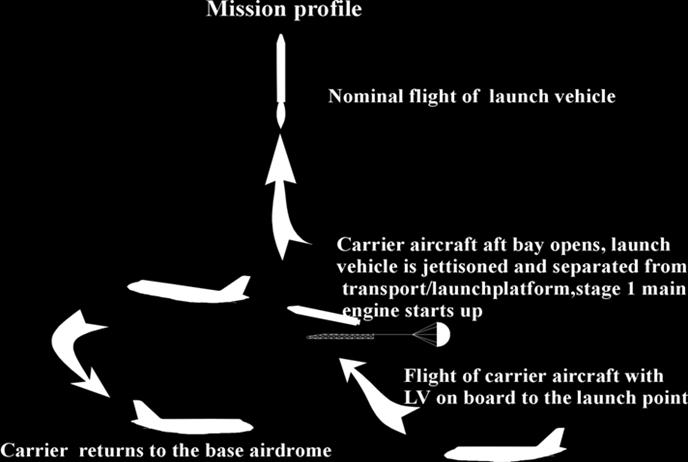
20 MICROSPACE Purpose of MICROSPACE is the injection of microsatellites into a wide orbit range using supersonic aircraft

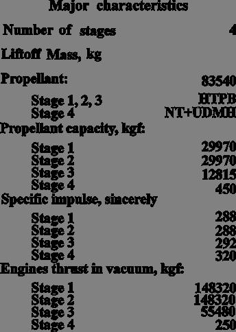
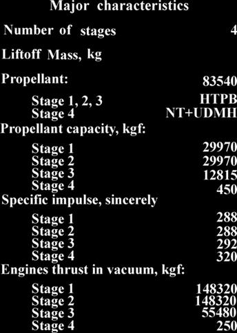
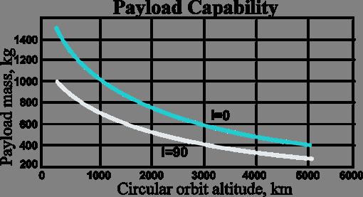
21 LV MAIN SPECIFICATIONS Number of stages 3 Launch mass, kg 4945 Propellant mass, kg: I stage 3000 II stage 1070 III stage 120 Length, mm 8490 Diameter, mm 1090 Orbit injected SC mass, kg: H=500 km, i=97,4 deg 65 H=500 km, i=0 deg 107

22 REUSABLE SPACE TRANSPORTATION SYSTEM RASSVET LIQUID ENGINE RD-8 BASED DEMONSTRATOR OF RSTS TECHNOLOGIES Planer Fuel tank RD-8 engines Oxidizer tank Landing gear Booster
23 DEMONSTRATOR OF RSTS TECHNOLOGIES WITH RAMJET ENGINE View A

24 ALGORITHM OF RAMJET ENGINE DEVELOPMENT FOR REUSABLE FIRST STAGE OF RASSVET RSTS RD-8 Engine chamber Demonstrator of RSTS technologies Ramjet engine Multi-chamber module Suborbital airborne vehicle of the RSTS Ramjet engine 2G 0 =400т 1G 0 =200т
25
26
27


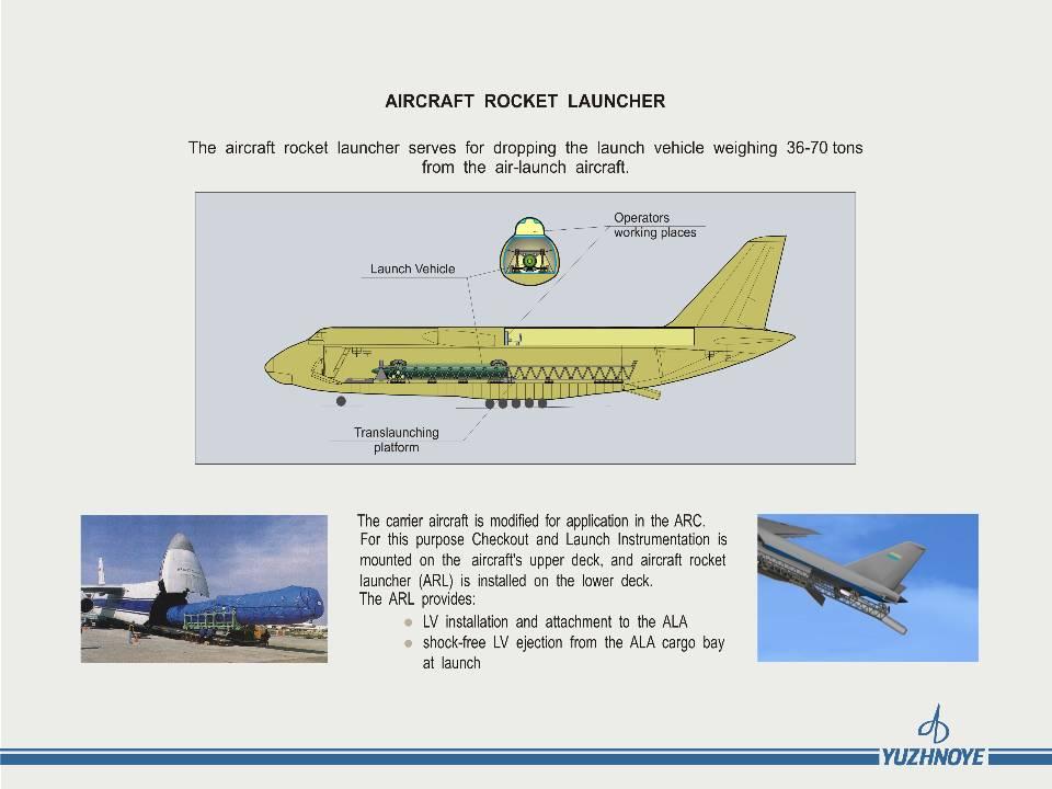
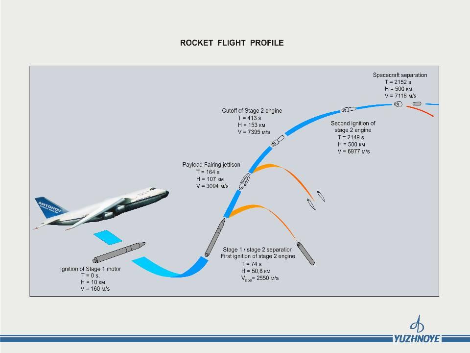
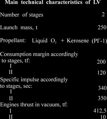
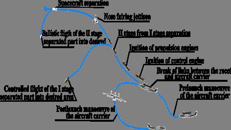
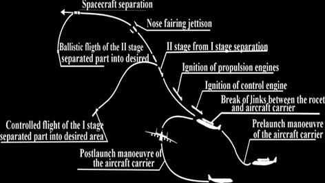
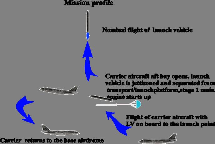
28 Aerospace rocket complex Svityaz is determined for injection of different SC to the circular, elliptical and higher circular orbits including geostationary orbit. Aircraft An is developed by Aviation Science-Technical complex named after O. Antonov. It is the modification of serial aircraft An-225 Mriya. Svityaz LV is developed on the base of units, aggregates and systems of Zenit LV. It includes three stages and is working on nontoxic fuel components - liquid oxygen and kerosene.
29
30
31
32 CONTACT DETAILS Stanislav Konyukhov General Designer- General Director Yuzhnoye SDO Alexander Degtyarev First Deputy General Designer- General Director Yuzhnoye SDO 3, Krivorozhskaya Street Dniepropetrovsk, UKRAINE, Phone: Fax: , Krivorozhskaya Street Dniepropetrovsk 49008, UKRAINE Phone: Fax: Oleg Ventskovsky Director European Representation Yuzhnoye SDO 20, rue Vautier, B-1050, Bruxelles, BELGIUM Phone/Fax +32 (2)
Research by Ukraine of the near Earth space
 MEETING BETWEEN YUZHNOYE SDO AND HONEYWELL, DECEMBER 8, 2009 Research by Ukraine of the near Earth space YUZHNOYE SDO PROPOSALS 50 th session FOR of COOPERATION STSC COPUOS WITH HONEYWELL Vienna 11-22
GLOBAL SATELLITE SYSTEM FOR MONITORING
 MEETING BETWEEN YUZHNOYE SDO AND HONEYWELL, International Astronautical Congress IAC-2012 DECEMBER 8, 2009 GLOBAL SATELLITE SYSTEM FOR MONITORING YUZHNOYE SDO PROPOSALS FOR COOPERATION WITH HONEYWELL EARTH
The Nemo Bus: A Third Generation Nanosatellite Bus for Earth Monitoring and Observation
 The Nemo Bus: A Third Generation Nanosatellite Bus for Earth Monitoring and Observation FREDDY M. PRANAJAYA Manager, Advanced Systems Group S P A C E F L I G H T L A B O R A T O R Y University of Toronto
Mission requirements and satellite overview
 Mission requirements and satellite overview E. BOUSSARIE 1 Dual concept Users need Defence needs Fulfil the Defence needs on confidentiality and security Civilian needs Fulfillment of the different needs
PEGASUS : a future tool for providing near real-time high resolution data for disaster management. Lewyckyj Nicolas
 PEGASUS : a future tool for providing near real-time high resolution data for disaster management Lewyckyj Nicolas nicolas.lewyckyj@vito.be http://www.pegasus4europe.com Overview Vito in a nutshell GI
Microsatellite Constellation for Earth Observation in the Thermal Infrared Region
 Microsatellite Constellation for Earth Observation in the Thermal Infrared Region Federico Bacci di Capaci Nicola Melega, Alessandro Tambini, Valentino Fabbri, Davide Cinarelli Observation Index 1. Introduction
Remote Sensing Platforms
 Types of Platforms Lighter-than-air Remote Sensing Platforms Free floating balloons Restricted by atmospheric conditions Used to acquire meteorological/atmospheric data Blimps/dirigibles Major role - news
Int n r t o r d o u d c u ti t on o n to t o Remote Sensing
 Introduction to Remote Sensing Definition of Remote Sensing Remote sensing refers to the activities of recording/observing/perceiving(sensing)objects or events at far away (remote) places. In remote sensing,
Geospatial Vision and Policies Korean Industry View 26 November, 2014 SI Imaging Services
 Geospatial Vision and Policies Korean Industry View 26 November, 2014 SI Imaging Services Distribution Limitation, SI Imaging Services Proprietary Data : The data contained in this document, without the
INTRODUCTION The validity of dissertation Object of investigation Subject of investigation The purpose: of the tasks The novelty:
 INTRODUCTION The validity of dissertation. According to the federal target program "Maintenance, development and use of the GLONASS system for 2012-2020 years the following challenges were determined:
Remote Sensing Platforms
 Remote Sensing Platforms Remote Sensing Platforms - Introduction Allow observer and/or sensor to be above the target/phenomena of interest Two primary categories Aircraft Spacecraft Each type offers different
FORMOSAT-5. - Launch Campaign-
 1 FORMOSAT-5 - Launch Campaign- FORMOSAT-5 Launch Campaign 2 FORMOSAT-5 Launch Campaign Launch Date: 2017.08.24 U.S. Pacific Time Activities 11:50-12:23 Launch Window 13:30-16:00 Reception 3 FORMOSAT-5
detected by Himawari-8 then the location will be uplinked to approaching Cubesats as an urgent location for medium resolution imaging.
 Title: Cubesat constellation for monitoring and detection of bushfires in Australia Primary Point of Contact (POC) & email: siddharth.doshi2@gmail.com Co-authors: Siddharth Doshi, David Lam, Himmat Panag
SOME ASPECT AND PERSPECTIVES OF IMPLEMENTATION OF THE NATIONAL POLICY IN THE FIELD OF EXPLORATION AND PEACEFUL USES OF OUTER SPACE
 SOME ASPECT AND PERSPECTIVES OF IMPLEMENTATION OF THE NATIONAL POLICY IN THE FIELD OF EXPLORATION AND PEACEFUL USES OF OUTER SPACE 1 Folie 1 NKS Raumfahrt, Dr. Adrian klein Background National Academy
CubeSat Integration into the Space Situational Awareness Architecture
 CubeSat Integration into the Space Situational Awareness Architecture Keith Morris, Chris Rice, Mark Wolfson Lockheed Martin Space Systems Company 12257 S. Wadsworth Blvd. Mailstop S6040 Littleton, CO
NON-PHOTOGRAPHIC SYSTEMS: Multispectral Scanners Medium and coarse resolution sensor comparisons: Landsat, SPOT, AVHRR and MODIS
 NON-PHOTOGRAPHIC SYSTEMS: Multispectral Scanners Medium and coarse resolution sensor comparisons: Landsat, SPOT, AVHRR and MODIS CLASSIFICATION OF NONPHOTOGRAPHIC REMOTE SENSORS PASSIVE ACTIVE DIGITAL
MISSION OVERVIEW SLC-37 CCAFS, FL
 MISSION OVERVIEW SLC-37 CCAFS, FL The ULA team is proud to be the launch provider for the U.S. Air Force (USAF) Global Positioning System (GPS) Directorate by delivering replenishment satellites aboard
Passive Microwave Sensors LIDAR Remote Sensing Laser Altimetry. 28 April 2003
 Passive Microwave Sensors LIDAR Remote Sensing Laser Altimetry 28 April 2003 Outline Passive Microwave Radiometry Rayleigh-Jeans approximation Brightness temperature Emissivity and dielectric constant
Wind Imaging Spectrometer and Humidity-sounder (WISH): a Practical NPOESS P3I High-spatial Resolution Sensor
: a Practical NPOESS P3I High-spatial Resolution Sensor") Wind Imaging Spectrometer and Humidity-sounder (WISH): a Practical NPOESS P3I High-spatial Resolution Sensor Jeffery J. Puschell Raytheon Space and Airborne Systems, El Segundo, California Hung-Lung Huang
Wind Imaging Spectrometer and Humidity-sounder (WISH): a Practical NPOESS P3I High-spatial Resolution Sensor Jeffery J. Puschell Raytheon Space and Airborne Systems, El Segundo, California Hung-Lung Huang
Science and Technology SATellite Program of KOREA
 Science and Technology SATellite Program of KOREA November 2, 2004-1- Contents Introduction KITSAT (Korea Institute of Technology SATellite) STSAT (Science and Technology SATellite) KOMPSAT (KOrea( Multi-Purpose
NEPTUNE 30. Micro Satellite Launch Vehicle. Interorbital Systems
 NEPTUNE 30 Micro Satellite Launch Vehicle : Mojave California Liquid Rocket Engine Tests IOS Areas of Specialization Orbital Launch Vehicles Sea Star TSAAHTO Micro Satellite Launch Vehicle (MSLV) Neptune
H ~ 580 mm Paper used: 0,26 mm gr ("cardstock") 0,15 mm gr Glue: PVA
 0,15 mm gr Glue: PVA") The Angara rocket family is a family of space-launch vehicles currently under development by the Khrunichev State Research and Production Space Center. The rockets, which are to provide lifting capabilities
The Angara rocket family is a family of space-launch vehicles currently under development by the Khrunichev State Research and Production Space Center. The rockets, which are to provide lifting capabilities
Outline for today. Geography 411/611 Remote sensing: Principles and Applications. Remote sensing: RS for biogeochemical cycles
 Geography 411/611 Remote sensing: Principles and Applications Thomas Albright, Associate Professor Laboratory for Conservation Biogeography, Department of Geography & Program in Ecology, Evolution, & Conservation
HEMERA Constellation of passive SAR-based micro-satellites for a Master/Slave configuration
 HEMERA Constellation of passive SAR-based micro-satellites for a Master/Slave HEMERA Team Members: Andrea Bellome, Giulia Broggi, Luca Collettini, Davide Di Ienno, Edoardo Fornari, Leandro Lucchese, Andrea
US Commercial Imaging Satellites
 US Commercial Imaging Satellites In the early 1990s, Russia began selling 2-meter resolution product from its archives of collected spy satellite imagery. Some of this product was down-sampled to provide
Lecture 6: Multispectral Earth Resource Satellites. The University at Albany Fall 2018 Geography and Planning
 Lecture 6: Multispectral Earth Resource Satellites The University at Albany Fall 2018 Geography and Planning Outline SPOT program and other moderate resolution systems High resolution satellite systems
AG-VA Fully Autonomous UAV Sprayers
 AG-VA Fully Autonomous UAV Sprayers One of the most advance sprayer technology on the market! Best Price - Best Flight Time - Best Coverage Rate - 1 Yr Warranty* The AG-VA UAV Sprayer is available in 3
REMOTE SENSING. Topic 10 Fundamentals of Digital Multispectral Remote Sensing MULTISPECTRAL SCANNERS MULTISPECTRAL SCANNERS
 REMOTE SENSING Topic 10 Fundamentals of Digital Multispectral Remote Sensing Chapter 5: Lillesand and Keifer Chapter 6: Avery and Berlin MULTISPECTRAL SCANNERS Record EMR in a number of discrete portions
STATUS OF CURRENT AND FUTURE RUSSIAN SATELLITE SYSTEMS by Roscosmos / Roshydromet. Presented to CGMS-45 plenary session
 STATUS OF CURRENT AND FUTURE RUSSIAN SATELLITE SYSTEMS by Roscosmos / Roshydromet Presented to CGMS-45 plenary session 2017 Objectives: Hydrometeorological Satellite Observation System HYDROMETEOROLOGY
Japan's Greenhouse Gases Observation from Space
 1 Workshop on EC CEOS Priority on GHG Monitoring Japan's Greenhouse Gases Observation from Space 18 June, 2018@Ispra, Italy Masakatsu NAKAJIMA Japan Aerospace Exploration Agency Development and Operation
CIRiS: Compact Infrared Radiometer in Space August, 2017
 1 CIRiS: Compact Infrared Radiometer in Space August, 2017 David Osterman PI, CIRiS Mission Presented by Hansford Cutlip 10/8/201 7 Overview of the CIRiS instrument and mission The CIRiS instrument is
Satellite Testing. Prepared by. A.Kaviyarasu Assistant Professor Department of Aerospace Engineering Madras Institute Of Technology Chromepet, Chennai
 Satellite Testing Prepared by A.Kaviyarasu Assistant Professor Department of Aerospace Engineering Madras Institute Of Technology Chromepet, Chennai @copyright Solar Panel Deployment Test Spacecraft operating
Philpot & Philipson: Remote Sensing Fundamentals Scanners 8.1 W.D. Philpot, Cornell University, Fall 2015
 Philpot & Philipson: Remote Sensing Fundamentals Scanners 8.1 8. SCANNERS 8.1 General Scanners are scanning radiometers which, when operated from an airborne or spaceborne platform, image the terrain in
High Resolution Sensor Test Comparison with SPOT, KFA1000, KVR1000, IRS-1C and DPA in Lower Saxony
 High Resolution Sensor Test Comparison with SPOT, KFA1000, KVR1000, IRS-1C and DPA in Lower Saxony K. Jacobsen, G. Konecny, H. Wegmann Abstract The Institute for Photogrammetry and Engineering Surveys
EXAMPLES OF TOPOGRAPHIC MAPS PRODUCED FROM SPACE AND ACHIEVED ACCURACY CARAVAN Workshop on Mapping from Space, Phnom Penh, June 2000
 EXAMPLES OF TOPOGRAPHIC MAPS PRODUCED FROM SPACE AND ACHIEVED ACCURACY CARAVAN Workshop on Mapping from Space, Phnom Penh, June 2000 Jacobsen, Karsten University of Hannover Email: karsten@ipi.uni-hannover.de
RECONNAISSANCE PAYLOADS FOR RESPONSIVE SPACE
 3rd Responsive Space Conference RS3-2005-5004 RECONNAISSANCE PAYLOADS FOR RESPONSIVE SPACE Charles Cox Stanley Kishner Richard Whittlesey Goodrich Optical and Space Systems Division Danbury, CT Frederick
IKONOS High Resolution Multispectral Scanner Sensor Characteristics
 High Spatial Resolution and Hyperspectral Scanners IKONOS High Resolution Multispectral Scanner Sensor Characteristics Launch Date View Angle Orbit 24 September 1999 Vandenberg Air Force Base, California,
India recently successfully launched its PSLV-C16 rocked that carried into orbit the latest remote
 India recently successfully launched its PSLV-C16 rocked that carried into orbit the latest remote sensing satellite REsourcesat-2 that would study and help manage natural resources along with two Nano
Monitoring Natural Disasters with Small Satellites Smart Satellite Based Geospatial System for Environmental Protection
 Monitoring Natural Disasters with Small Satellites Smart Satellite Based Geospatial System for Environmental Protection Krištof Oštir, Space-SI, Slovenia Contents Natural and technological disasters Current
Radiometric performance of Second Generation Global Imager (SGLI) using integrating sphere
 using integrating sphere") Radiometric performance of Second Generation Global Imager (SGLI) using integrating sphere Taichiro Hashiguchi, Yoshihiko Okamura, Kazuhiro Tanaka, Yukinori Nakajima Japan Aerospace Exploration Agency
Radiometric performance of Second Generation Global Imager (SGLI) using integrating sphere Taichiro Hashiguchi, Yoshihiko Okamura, Kazuhiro Tanaka, Yukinori Nakajima Japan Aerospace Exploration Agency
Outline. Introduction. Introduction: Film Emulsions. Sensor Systems. Types of Remote Sensing. A/Prof Linlin Ge. Photographic systems (cf(
 GMAT x600 Remote Sensing / Earth Observation Types of Sensor Systems (1) Outline Image Sensor Systems (i) Line Scanning Sensor Systems (passive) (ii) Array Sensor Systems (passive) (iii) Antenna Radar
Chapter 3 Solution to Problems
 Chapter 3 Solution to Problems 1. The telemetry system of a geostationary communications satellite samples 100 sensors on the spacecraft in sequence. Each sample is transmitted to earth as an eight-bit
CAL/VAL ACTIVITIES IN ROSHYDROMET. GSICS Executive Panel 14, Tokyo, 15 July. 2013
 CAL/VAL ACTIVITIES IN ROSHYDROMET GSICS Executive Panel 14, Tokyo, 15 July. 2013 Future CAL/VAL system deployment in Roshydromet Roshydromet has started the deployment of ground-based calibration/validation
STRATEGIC CHOICES FOR SMALL AND MIDDLE POWERS
 Chapter Five STRATEGIC CHOICES FOR SMALL AND MIDDLE POWERS SPACE DEVELOPMENT IN KOREA Hong-Yul Paik, Director, Satellite Operation Center, Korea Aerospace Research Institute, South Korea Korea is a young
The Challenge. SPOT Vegetation. miniaturization. Proba Vegetation. Technology assessment:
 The Challenge Spot-5 lifetime expires in 2012. The next French satellite, Pleiades, is solely dedicated to HiRes. The Belgian Federal Science Policy Office (BELSPO) declared their interest to develop an
Solar Power Satellite, Space Elevator, and Reusable Launch
 AIAA-2010-791690 Solar Power Satellite, Space Elevator, and Reusable Launch Dr. James A. Martin Consultant, Associate Editor JSR Space 2010 Conference Anaheim, CA August 30, 2010 Solar Power Satellites
Baumanets student micro-satellite
 Baumanets student micro-satellite Presentation at UNIVERSAT 2006 International Symposium June 28, 2006 Moscow, Russia Victoria Mayorova Director of Youth Space Center of Bauman Moscow State Technical University
Aral Sea profile Selection of area 24 February April May 1998
 250 km Aral Sea profile 1960 1960 1985 1986 1987 1988 1989 1990 1991 1992 1993 1994 1995 1996 1997 1998 2010? Selection of area Area of interest Kzyl-Orda Dried seabed 185 km Syrdarya river Aral Sea Salt
Space Debris Mitigation Status of China s Launch Vehicle
 Space Debris Mitigation Status of China s Launch Vehicle SONG Qiang (Beijing Institute of Aerospace Systems Engineering) Abstract: China s launch vehicle has being developed for more than 40 years. Various
Four Aerospace Issues Addressed by the Kennedy Space Center Applied Physics Lab
 Four Aerospace Issues Addressed by the Kennedy Space Center Applied Physics Lab June 20, 2017 Robert C. Youngquist Four Aerospace Issues at KSC The KSC Applied Physics Lab (formed in 1989) helps the programs
RADIOMETRIC TRACKING. Space Navigation
 RADIOMETRIC TRACKING Space Navigation Space Navigation Elements SC orbit determination Knowledge and prediction of SC position & velocity SC flight path control Firing the attitude control thrusters to
THE SPACE TECHNOLOGY RESEARCH VEHICLE 2 MEDIUM WAVE INFRA RED IMAGER
 THE SPACE TECHNOLOGY RESEARCH VEHICLE 2 MEDIUM WAVE INFRA RED IMAGER S J Cawley, S Murphy, A Willig and P S Godfree Space Department The Defence Evaluation and Research Agency Farnborough United Kingdom
Introduction to MATE-CON. Presented By Hugh McManus Metis Design 3/27/03
 Introduction to MATE-CON Presented By Hugh McManus Metis Design 3/27/03 A method for the front end MATE Architecture Tradespace Exploration A process for understanding complex solutions to complex problems
9/12/2011. Training Course Remote Sensing Basic Theory & Image Processing Methods September 2011
 Training Course Remote Sensing Basic Theory & Image Processing Methods 19 23 September 2011 Popular Remote Sensing Sensors & their Selection Michiel Damen (September 2011) damen@itc.nl 1 Overview Low resolution
AGRON / E E / MTEOR 518: Microwave Remote Sensing
 AGRON / E E / MTEOR 518: Microwave Remote Sensing Dr. Brian K. Hornbuckle, Associate Professor Departments of Agronomy, ECpE, and GeAT bkh@iastate.edu What is remote sensing? Remote sensing: the acquisition
Airbus DS ESA Phase-0 L5 Spacecraft/Orbital Concept Overview. Emanuele Monchieri 6 th March 2017
 Airbus DS ESA Phase-0 L5 Spacecraft/Orbital Concept Overview Emanuele Monchieri 6 th March 2017 Airbus DS ESA Phase-0 L5 Spacecraft/Orbital Concept Overview Contents L5 Mission Outline Mission Concept
CubeSat Propulsion using Electrospray Thrusters
 CubeSat Propulsion using Electrospray Thrusters Tom Roy, Nathaniel Demmons, Vlad Hruby, Nathan Rosenblad, Peter Rostler and Douglas Spence Busek Co., Natick, MA 01760 Paper SSC09-II-6 SmallSat Conference,
Research Activities on Small Satellite in HIT
 7th UK-China Workshop on Space Science and Technology Research Activities on Small Satellite in HIT Prof. ZHANG Shijie (RCST) Contents 7th UK-China Workshop on Space Science and Technology 1. RCST Overview
Detection and Monitoring Through Remote Sensing....The Need For A New Remote Sensing Platform
 WILDFIRES Detection and Monitoring Through Remote Sensing...The Need For A New Remote Sensing Platform Peter Kimball ASEN 5235 Atmospheric Remote Sensing 5/1/03 1. Abstract This paper investigates the
Istanbul Technical University Faculty of Aeronautics and Astronautics Space Systems Design and Test Laboratory
 Title: Space Advertiser (S-VERTISE) Primary POC: Aeronautics and Astronautics Engineer Hakan AYKENT Organization: Istanbul Technical University POC email: aykent@itu.edu.tr Need Worldwide companies need
RECOMMENDATION ITU-R SA (Question ITU-R 210/7)
") Rec. ITU-R SA.1016 1 RECOMMENDATION ITU-R SA.1016 SHARING CONSIDERATIONS RELATING TO DEEP-SPACE RESEARCH (Question ITU-R 210/7) Rec. ITU-R SA.1016 (1994) The ITU Radiocommunication Assembly, considering
Rec. ITU-R SA.1016 1 RECOMMENDATION ITU-R SA.1016 SHARING CONSIDERATIONS RELATING TO DEEP-SPACE RESEARCH (Question ITU-R 210/7) Rec. ITU-R SA.1016 (1994) The ITU Radiocommunication Assembly, considering
ECE 6390: Satellite Communications and Navigation Systems TEST 1 (Fall 2010)
") Name: GTID: ECE 6390: Satellite Communications and Navigation Systems TEST 1 (Fall 2010) Please read all instructions before continuing with the test. This is a closed notes, closed book, closed friend,
Name: GTID: ECE 6390: Satellite Communications and Navigation Systems TEST 1 (Fall 2010) Please read all instructions before continuing with the test. This is a closed notes, closed book, closed friend,
ACTIVITY OF RUSSIAN FEDERATION ON SPACE DEBRIS PROBLEM
 FEDERAL SPACE AGENCY OF RUSSIA CENTRAL RESEARCH INSTITUTE OF MACHINE BUILDING ACTIVITY OF RUSSIAN FEDERATION ON SPACE DEBRIS PROBLEM 46-th session of the Scientific and Technical Subcommittee of the UN
A CONCEPT FOR NATURAL GAS TRANSMISSION PIPELINE MONITORING BASED ON NEW HIGH-RESOLUTION REMOTE SENSING TECHNOLOGIES
 A CONCEPT FOR NATURAL GAS TRANSMISSION PIPELINE MONITORING BASED ON NEW HIGH-RESOLUTION REMOTE SENSING TECHNOLOGIES Werner Zirnig - Ruhrgas Aktiengesellschaft Dieter Hausamann - DLR German Aerospace Center
Remote Sensing. Division C. Written Exam
 Remote Sensing Division C Written Exam Team Name: Team #: Team Members: _ Score: /132 A. Matching (10 points) 1. Nadir 2. Albedo 3. Diffraction 4. Refraction 5. Spatial Resolution 6. Temporal Resolution
HYPERCUBE: Hyperspectral Imaging Using a CUBESAT
 HYPERCUBE: Hyperspectral Imaging Using a CUBESAT Ian S. Robinson Senior Engineering Fellow Raytheon Certified Architect Ian.Robinson@Raytheon.com Customer Success Is Our Mission Copyright 2011 Raytheon
Chapter 8. Remote sensing
 1. Remote sensing 8.1 Introduction 8.2 Remote sensing 8.3 Resolution 8.4 Landsat 8.5 Geostationary satellites GOES 8.1 Introduction What is remote sensing? One can describe remote sensing in different
A Framework for Incorporating ilities in Tradespace Studies
 A Framework for Incorporating ilities in Tradespace Studies September 20, 2007 H. McManus, M. Richards, A. Ross, and D. Hastings Massachusetts Institute of Technology Need for ilities Washington, DC in
HYDROS Development of a CubeSat Water Electrolysis Propulsion System
 HYDROS Development of a CubeSat Water Electrolysis Propulsion System Vince Ethier, Lenny Paritsky, Todd Moser, Jeffrey Slostad, Robert Hoyt Tethers Unlimited, Inc 11711 N. Creek Pkwy S., Suite D113, Bothell,
KEY TECHNOLOGY DEVELOPMENT FOR THE ADVENACED LAND OBSERVING SATELLITE
 KEY TECHNOLOGY DEVELOPMENT FOR THE ADVENACED LAND OBSERVING SATELLITE Takashi HAMAZAKI, and Yuji OSAWA National Space Development Agency of Japan (NASDA) hamazaki.takashi@nasda.go.jp yuji.osawa@nasda.go.jp
Study of Polarimetric Calibration for Circularly Polarized Synthetic Aperture Radar
 Study of Polarimetric Calibration for Circularly Polarized Synthetic Aperture Radar 2016.09.07 CEOS WORKSHOP 2016 Yuta Izumi, Sevket Demirci, Mohd Zafri Baharuddin, and Josaphat Tetuko Sri Sumantyo JOSAPHAT
CYGNSS Mission Update
 International Ocean Vector Wind Science Team Meeting Portland, OR 19-21 May 2015 CYGNSS Mission Update Chris Ruf (1) CYGNSS Principal Investigator Paul Chang (2), Maria Paola Clarizia (1), Scott Gleason
Abstract Quickbird Vs Aerial photos in identifying man-made objects
 Abstract Quickbird Vs Aerial s in identifying man-made objects Abdullah Mah abdullah.mah@aramco.com Remote Sensing Group, emap Division Integrated Solutions Services Department (ISSD) Saudi Aramco, Dhahran
Introduction to Remote Sensing Fundamentals of Satellite Remote Sensing. Mads Olander Rasmussen
 Introduction to Remote Sensing Fundamentals of Satellite Remote Sensing Mads Olander Rasmussen (mora@dhi-gras.com) 01. Introduction to Remote Sensing DHI What is remote sensing? the art, science, and technology
A 1m Resolution Camera For Small Satellites
 A 1m Resolution Camera For Small Satellites Paper SSC06-X-5 Presenter: Jeremy Curtis 1 Introduction TopSat launched October 2005 carrying RAL s 2.5m GSD camera into a 686km orbit Built and operated by
Workshop on Intelligent System and Applications (ISA 17)
") Telemetry Mining for Space System Sara Abdelghafar Ahmed PhD student, Al-Azhar University Member of SRGE Workshop on Intelligent System and Applications (ISA 17) 13 May 2017 Workshop on Intelligent System
Telemetry Mining for Space System Sara Abdelghafar Ahmed PhD student, Al-Azhar University Member of SRGE Workshop on Intelligent System and Applications (ISA 17) 13 May 2017 Workshop on Intelligent System
Remote Sensing in Daily Life. What Is Remote Sensing?
 Remote Sensing in Daily Life What Is Remote Sensing? First time term Remote Sensing was used by Ms Evelyn L Pruitt, a geographer of US in mid 1950s. Minimal definition (not very useful): remote sensing
Orbicraft Pro Complete CubeSat kit based on Raspberry-Pi
 Orbicraft Pro Complete CubeSat kit based on Raspberry-Pi (source IAA-AAS-CU-17-10-05) Speaker: Roman Zharkikh Authors: Roman Zharkikh Zaynulla Zhumaev Alexander Purikov Veronica Shteyngardt Anton Sivkov
Current and Future Meteorological Satellite Program of China
 Current and Future Meteorological Satellite Program of China ZHANG Wenjian, DONG Chaohua XU Jianmin, YANG Jun China Meteorological Administration May 30, 2005 Beijing, CHINA Outline of the Presentation
Radar Reprinted from "Waves in Motion", McGourty and Rideout, RET 2005
 Radar Reprinted from "Waves in Motion", McGourty and Rideout, RET 2005 What is Radar? RADAR (Radio Detection And Ranging) is a way to detect and study far off targets by transmitting a radio pulse in the
RADIOMETRIC TRACKING. Space Navigation
 RADIOMETRIC TRACKING Space Navigation October 24, 2016 D. Kanipe Space Navigation Elements SC orbit determination Knowledge and prediction of SC position & velocity SC flight path control Firing the attitude
Information furnished in conformity with the Convention on Registration of Objects Launched into Outer Space
 United Nations Secretariat Distr.: General 9 September 2003 Original: English Committee on the Peaceful Uses of Outer Space Information furnished in conformity with the Convention on Registration of Objects
European Manned Space Projects and related Technology Development. Dipl.Ing. Jürgen Herholz Mars Society Deutschland Board Member marssociety.
 European Manned Space Projects and related Technology Development Dipl.Ing. Jürgen Herholz Mars Society Deutschland Board Member marssociety.de EMC18 26-29 October 2018 jherholz@yahoo.de 1 European Projects
NASA Earth Science Division Status and Decadal Survey Thoughts Michael H. Freilich
 NASA Earth Science Division Status and Decadal Survey Thoughts Michael H. Freilich March 4, 2014 Earth Science Program Overall Strategy Freilich Maintain a balanced program that: advances Earth System
Primary POC: Prof. Hyochoong Bang Organization: Korea Advanced Institute of Science and Technology KAIST POC
 Title: Demonstration of Optical Stellar Interferometry with Near Earth Objects (NEO) using Laser Range Finder by a Nano Satellite Constellation: A Cost effective approach. Primary POC: Prof. Hyochoong
Microwave Remote Sensing (1)
") Microwave Remote Sensing (1) Microwave sensing encompasses both active and passive forms of remote sensing. The microwave portion of the spectrum covers the range from approximately 1cm to 1m in wavelength.
Microwave Remote Sensing (1) Microwave sensing encompasses both active and passive forms of remote sensing. The microwave portion of the spectrum covers the range from approximately 1cm to 1m in wavelength.
Credits. National Aeronautics and Space Administration. United Space Alliance, LLC. John Frassanito and Associates Strategic Visualization
 A New Age in Space The Vision for Space Exploration Credits National Aeronautics and Space Administration United Space Alliance, LLC John Frassanito and Associates Strategic Visualization Coalition for
Advanced Optical Satellite (ALOS-3) Overviews
 Overviews") K&C Science Team meeting #24 Tokyo, Japan, January 29-31, 2018 Advanced Optical Satellite (ALOS-3) Overviews January 30, 2018 Takeo Tadono 1, Hidenori Watarai 1, Ayano Oka 1, Yousei Mizukami 1, Junichi
K&C Science Team meeting #24 Tokyo, Japan, January 29-31, 2018 Advanced Optical Satellite (ALOS-3) Overviews January 30, 2018 Takeo Tadono 1, Hidenori Watarai 1, Ayano Oka 1, Yousei Mizukami 1, Junichi
Analysis of Potential for Venus-Bound Cubesat Scientific Investigations
 Analysis of Potential for Venus-Bound Cubesat Scientific Investigations Image Sources: Earth Science and Remote Sensing Unit, NASA Johnson Space Center; JAXA / ISAS / DARTS / Damia Bouic / Elsevier inc.
CHAPTER 6 ENVIRONMENTAL CONDITIONS
 CHAPTER 6 ENVIRONMENTAL CONDITIONS 6.1 Summary This Chapter provides the natural environment at Xichang Satellite Launch Center (XSLC), the thermal environment during satellite processing, the thermal
Project of space experiment "Shadow" on ISS
 Project of space experiment "Shadow" on ISS New challenge and new opportunity for Amateur Radio Community 22.05.2004 1 Invitation Russian Aviation and Space Agency (Rosaviacosmos, the Russian analogue
An Introduction to Geomatics. Prepared by: Dr. Maher A. El-Hallaq خاص بطلبة مساق مقدمة في علم. Associate Professor of Surveying IUG
 An Introduction to Geomatics خاص بطلبة مساق مقدمة في علم الجيوماتكس Prepared by: Dr. Maher A. El-Hallaq Associate Professor of Surveying IUG 1 Airborne Imagery Dr. Maher A. El-Hallaq Associate Professor
Presentation to the UN COPUOS STSC LTSSA Workshop. ISO Space Standards. 14 February 2013
 Presentation to the UN COPUOS STSC LTSSA Workshop ISO Space Standards 14 February 2013 by Frederick A. Slane Head, U.S. Delegation ISO TC20/SC14 Executive Director Space Infrastructure Foundation Purpose
Kennedy Space Center. Connecting Space Grant with Spaceport and Range Technology and Science Thrust Areas
 Kennedy Space Center Connecting Space Grant with Spaceport and Range Technology and Science Thrust Areas Michael Freeman, PhD michael.freeman@nasa.gov Kennedy Space Center Mission Space Launch Operations
Satellite/Aircraft Imaging Systems Imaging Sensors Standard scanner designs Image data formats
 CEE 6150: Digital Image Processing 1 Satellite/Aircraft Imaging Systems Imaging Sensors Standard scanner designs Image data formats CEE 6150: Digital Image Processing 2 CEE 6150: Digital Image Processing
KOMPSAT Constellation. November 2012 Satrec Initiative
 KOMPSAT Constellation November 2012 Satrec Initiative KOMPSAT Constellation KOMPSAT National program Developed and operated by KARI (Korea Aerospace Research Institute) Dual use : Government & commercial
Geo/SAT 2 INTRODUCTION TO REMOTE SENSING
 Geo/SAT 2 INTRODUCTION TO REMOTE SENSING Paul R. Baumann, Professor Emeritus State University of New York College at Oneonta Oneonta, New York 13820 USA COPYRIGHT 2008 Paul R. Baumann Introduction Remote
launch probability of success
 Using Architecture Models to Understand Policy Impacts Utility 1 0.995 0.99 Policy increases cost B C D 10 of B-TOS architectures have cost increase under restrictive launch policy for a minimum cost decision
OVERVIEW OF THE ALOS SATELLITE SYSTEM
 OVERVIEW OF THE ALOS SATELLITE SYSTEM Presented to The Symposium for ALOS Data Application Users @Kogakuin University, Tokyo, Japan Mar. 27, 2001 Takashi Hamazaki Senior Engineer ALOS Project National
Final Examination Introduction to Remote Sensing. Time: 1.5 hrs Max. Marks: 50. Section-I (50 x 1 = 50 Marks)
") Final Examination Introduction to Remote Sensing Time: 1.5 hrs Max. Marks: 50 Note: Attempt all questions. Section-I (50 x 1 = 50 Marks) 1... is the technology of acquiring information about the Earth's
Final Examination Introduction to Remote Sensing Time: 1.5 hrs Max. Marks: 50 Note: Attempt all questions. Section-I (50 x 1 = 50 Marks) 1... is the technology of acquiring information about the Earth's