Agency Report Na/onal Ins/tute for Space Research INPE Brazil. Lubia Vinhas. WGISS/CEOS 42 Mee/ng, September 2016, Frasca/, Italy
|
|
|
- Cecilia Boone
- 6 years ago
- Views:
Transcription
1 Agency Report Na/onal Ins/tute for Space Research INPE Brazil Lubia Vinhas WGISS/CEOS 42 Mee/ng, September 2016, Frasca/, Italy


2 INPE: CONVERTING DATA INTO KNOWLEDGE SATELLITES Earth observa/on, scien/fic, and data collec/on satellites GROUND SYSTEMS Satellite control, recep/on, processing and distribu/on of satellite data ANALYSIS AND MODELLING Space Weather, Weather Predic/on and Earth System Science SOCIETAL BENEFITS Innova/ve products to meet Brazil s needs
3 Fostering the concept of public- good data Brazil, 2004 INPE set a free data policy for CBERS in Brazil CBERS data available free of charges on the Web Impacts on EO consulting and services in Brazil Increasing EO data distribution for society South Africa, 2007 Announcement of the CBERS for Africa Initiative Extension of CBERS free data policy for Africa America, 2008 USGS adopted a free data policy for Landsat Landsat image data also available free of charges Europe, 2009 ESA announced a free data policy for Sentinels
4 CBERS Program - Status CBERS-3 was lost after a failure in the last stage of the launching rocket in CBERS-4 was successfully launched in December CBERS-4 images have been regularly acquired in Cuiabá. Commissioning phase was executed from December 2015 to May 2016 to assess and validate CBERS-4 cameras. Images are available on the web (www2.dgi.inpe.br/cdsr).
5 CBERS 3 & 4 2 nd genera/on series Sun- synchronous orbit Al/tude = 778 km Inclina/on = 98.5º Nodal period = minutes Repeat cycle = 26 days Descending node at 10h30 local /me
6 CBERS 3 & 4 2 nd genera/on series Parameter CBERS 1, 2, 2B CBERS 3, 4 Total mass 1,450 kg 2,020 kg Power 1,100 W 2,300 W Data rate 100 Mbit/s 305 Mbit/s Design life/me 2 years 3 years
7 CBERS 3 & 4 cameras Payloads MUX PAN IRS WFI Manufacturer Brazil China China Brazil Type Pushbroom Pushbroom Scanner Pushbroom Revisit /me 26 days 52 days (nadir opera/on) side looking (32 degrees) 26 days 5 days Quan/za/on 8 bits 8 bits 8 bits 10 bits Data rate 68 Mbits/s 67, 100 Mbits/s 17 Mbits/s 53 Mbits/s Compression 2:1 pan band
8 CBERS 3 & 4 cameras Payloads MUX PAN IRS WFI Band µm µm µm µm Band µm µm µm µm Band µm µm µm µm Band µm µm µm µm Resolu/on 20 m 5 m, 10 m 40 m, 80 m 70 m Swath width 120 km 60 km 120 km 866 km
9 Basic processing levels of CBERS- 4 L0: raw image data. L1: radiometrically corrected images. L2: L1 plus geometric system-correction. L3: L2 plus registration through ground control points. L4: L2 plus registration through ground control points and terrain correction (orthorectification). L3 and L4 are processed automatically by means of image correlation techniques and geometric transformations.
10 Internal accuracy es/ma/on for MUX Points Scenes L4 (m) L4 > > > > Ground control points extracted from terrain- corrected (orthorec/fied) Landsat- 8 images : root mean square error; : standard devia/on; CT: across- track; AT: along- track
11 Internal accuracy es/ma/on for MUX Points Scenes L3 (m) L3 > Points Scenes L2 AGer translahon (m) L2 AGer translahon > Ground control points extracted from terrain- corrected (orthorec/fied) Landsat- 8 images : root mean square error; : standard devia/on; CT: across- track; AT: along- track
12 Internal accuracy es/ma/on for WFI Points Scenes L4 (m) L4 > > > > Ground control points extracted from subsampled terrain- corrected Landsat- 8 images : root mean square error; : standard devia/on; CT: across- track; AT: along- track
13 Internal accuracy es/ma/on for WFI Points Scenes L3 (m) L3 > Points Scenes L2 AGer translahon (m) L2 AGer translahon > Ground control points extracted from subsampled terrain- corrected Landsat- 8 images : root mean square error; : standard devia/on; CT: across- track; AT: along- track
14 Internal accuracy es/ma/on for PAN5 Points Scenes L4 (m) L4 > > > > Ground control points extracted from terrain- corrected (orthorec/fied) RapidEye images : root mean square error; : standard devia/on; CT: across- track; AT: along- track
15 Internal accuracy es/ma/on for PAN5 Points Scenes L3 (m) L3 > Points Scenes L2 AGer translahon (m) L2 AGer translahon > Ground control points extracted from terrain- corrected (orthorec/fied) RapidEye images : root mean square error; : standard devia/on; CT: across- track; AT: along- track
16 Internal accuracy es/ma/on for PAN10 Points Scenes L4 (m) L4 > > > > Ground control points extracted from terrain- corrected (orthorec/fied) RapidEye images : root mean square error; : standard devia/on; CT: across- track; AT: along- track
17 Internal accuracy es/ma/on for PAN10 Points Scenes L3 (m) L3 > Points Scenes L2 AGer translahon (m) L2 AGer translahon > Ground control points extracted from terrain- corrected (orthorec/fied) RapidEye images : root mean square error; : standard devia/on; CT: across- track; AT: along- track
18 Internal accuracy es/ma/on for IRS Points Scenes L4 (m) L4 > > > > Ground control points extracted from terrain- corrected (orthorec/fied) Landsat- 8 images : root mean square error; : standard devia/on; CT: across- track; AT: along- track
19 Internal accuracy es/ma/on for IRS Points Scenes L3 (m) L3 > Points Scenes L2 AGer translahon (m) L2 AGer translahon > Ground control points extracted from terrain- corrected (orthorec/fied) Landsat- 8 images : root mean square error; : standard devia/on; CT: across- track; AT: along- track
20 Summarizing MUX L4 images are suitable for mapping at scales 1:50,000 and smaller. WFI L4 images are suitable for mapping at scales 1:250,000 and smaller. PAN5 and PAN10 L4 images are suitable for mapping at scales 1:50,000 and smaller. IRS L4 images are suitable for mapping at scales 1:100,000 and smaller. These conclusions are based on the comparison of resulting s with commonly accepted cartographic standards.
21 Summarizing MUX L4 images are extremely consistent in time in terms of their geometric internal accuracies. Although WFI L4 images have acceptable geometric internal accuracies, a refinement in the optical distortion model of the two optical systems of the camera is still being analyzed. PAN5 and PAN10 L4 images have acceptable geometric internal accuracies that are about to be improved by the application of optical distortion models provided recently by our Chinese partners. IRS L4 geometric internal accuracies are not as acceptable as it should be, as a result of inaccurate modeling of its camera push broom system.
22 SOME IMAGES

23 Brasilia, DF, Brazil - MUX

24 Rio de Janeiro, RJ, Brazil - PAN - 10
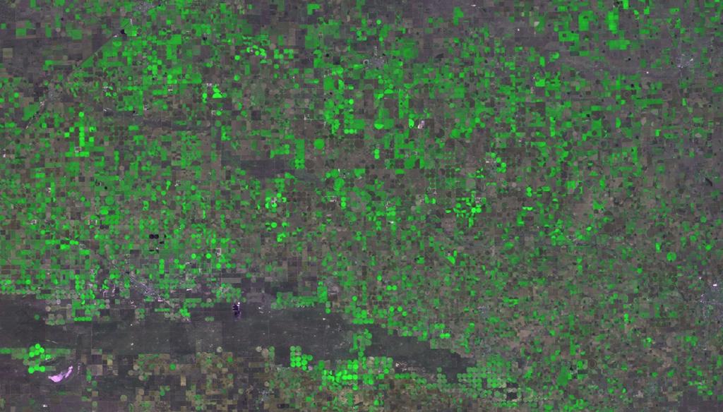
25 EUA WFI

26 Uyuni Salar, Chile WFI

27 Uyuni Salar, Chile Pan 10

28 Distribu/on Images are available on the web (www2.dgi.inpe.br/cdsr). 21,381 scenes last 2 months: 9,117 MUX, 5,299 PAN 10, 4,274 PAN 5, 2,089 WFI and 602 IRS

29 Distribu/on PHP access API to support CWIC connector

30 Discovery OpenSearch prototype implementation

31 Discovery OpenSearch prototype implementation

32 CBERS 4A equipment reuse Sun- synchronous orbit Al/tude = 628 km Inclina/on = 97.89º Repeat cycle = 31 days Descending node at 10h30 local /me Launching: 2018
33 CBERS 4A cameras Payloads MUX WPM WFI Manufacturer Brazil China Brazil Type Pushbroom Pushbroom TDI Pushbroom Revisit /me 31 days 31 days 5 days Quan/za/on 8 bits 10 bits 10 bits Swath width 95 km 92 km 684 km
34 CBERS 4A cameras Payloads MUX WPM WFI Band µm µm µm Band µm µm µm Band µm µm µm Band µm µm µm Band 5 (PAN) µm Resolu/on 16 m 2 m, 8 m 55 m
35 OBRIGADO. GRAZIE.
PLANET IMAGERY PRODUCT SPECIFICATIONS PLANET.COM
 PLANET IMAGERY PRODUCT SPECIFICATIONS SUPPORT@PLANET.COM PLANET.COM LAST UPDATED JANUARY 2018 TABLE OF CONTENTS LIST OF FIGURES 3 LIST OF TABLES 4 GLOSSARY 5 1. OVERVIEW OF DOCUMENT 7 1.1 Company Overview
Abstract Quickbird Vs Aerial photos in identifying man-made objects
 Abstract Quickbird Vs Aerial s in identifying man-made objects Abdullah Mah abdullah.mah@aramco.com Remote Sensing Group, emap Division Integrated Solutions Services Department (ISSD) Saudi Aramco, Dhahran
KOMPSAT Constellation. November 2012 Satrec Initiative
 KOMPSAT Constellation November 2012 Satrec Initiative KOMPSAT Constellation KOMPSAT National program Developed and operated by KARI (Korea Aerospace Research Institute) Dual use : Government & commercial
Geometric Quality Assessment of CBERS-2. Julio d Alge Ricardo Cartaxo Guaraci Erthal
 Geometric Quality Assessment of CBERS-2 Julio d Alge Ricardo Cartaxo Guaraci Erthal Contents Monitoring CBERS-2 scene centers Satellite orbit control Band-to-band registration accuracy Detection and control
NON-PHOTOGRAPHIC SYSTEMS: Multispectral Scanners Medium and coarse resolution sensor comparisons: Landsat, SPOT, AVHRR and MODIS
 NON-PHOTOGRAPHIC SYSTEMS: Multispectral Scanners Medium and coarse resolution sensor comparisons: Landsat, SPOT, AVHRR and MODIS CLASSIFICATION OF NONPHOTOGRAPHIC REMOTE SENSORS PASSIVE ACTIVE DIGITAL
GEOMETRIC RECTIFICATION OF EUROPEAN HISTORICAL ARCHIVES OF LANDSAT 1-3 MSS IMAGERY
 GEOMETRIC RECTIFICATION OF EUROPEAN HISTORICAL ARCHIVES OF LANDSAT -3 MSS IMAGERY Torbjörn Westin Satellus AB P.O.Box 427, SE-74 Solna, Sweden tw@ssc.se KEYWORDS: Landsat, MSS, rectification, orbital model
Update on Landsat Program and Landsat Data Continuity Mission
 Update on Landsat Program and Landsat Data Continuity Mission Dr. Jeffrey Masek LDCM Deputy Project Scientist NASA GSFC, Code 923 November 21, 2002 Draft LDCM Implementation Phase RFP Overview Page 1 Celebrate!
Aral Sea profile Selection of area 24 February April May 1998
 250 km Aral Sea profile 1960 1960 1985 1986 1987 1988 1989 1990 1991 1992 1993 1994 1995 1996 1997 1998 2010? Selection of area Area of interest Kzyl-Orda Dried seabed 185 km Syrdarya river Aral Sea Salt
Monitoring Natural Disasters with Small Satellites Smart Satellite Based Geospatial System for Environmental Protection
 Monitoring Natural Disasters with Small Satellites Smart Satellite Based Geospatial System for Environmental Protection Krištof Oštir, Space-SI, Slovenia Contents Natural and technological disasters Current
Data Sharing Issues in SE Asia
 Data Sharing Issues in SE Asia Kandasri Limpakom User Service and Business Development Office About GISTDA THEOS & Its Applications GISTDA s Data Sharing Geo-Informatics and Space Technology Development
Copernicus Introduction Lisbon, Portugal 13 th & 14 th February 2014
 Copernicus Introduction Lisbon, Portugal 13 th & 14 th February 2014 Contents Introduction GMES Copernicus Six thematic areas Infrastructure Space data An introduction to Remote Sensing In-situ data Applications
OVERVIEW OF KOMPSAT-3A CALIBRATION AND VALIDATION
 OVERVIEW OF KOMPSAT-3A CALIBRATION AND VALIDATION DooChun Seo 1, GiByeong Hong 1, ChungGil Jin 1, DaeSoon Park 1, SukWon Ji 1 and DongHan Lee 1 1 KARI(Korea Aerospace Space Institute), 45, Eoeun-dong,
STRIPING NOISE REMOVAL OF IMAGES ACQUIRED BY CBERS 2 CCD CAMERA SENSOR
 STRIPING NOISE REMOVAL OF IMAGES ACQUIRED BY CBERS 2 CCD CAMERA SENSOR a E. Amraei a, M. R. Mobasheri b MSc. Electrical Engineering department, Khavaran Higher Education Institute, erfan.amraei7175@gmail.com
Rapideye (2008 -> ) Not just another high resolution satellite sensor. 5 satellites RapidEye constellation. 5 million km² daily collection capacity
 Not just another high resolution satellite sensor. 5 satellites RapidEye constellation. 5 million km² daily collection capacity") Rapideye (2008 -> ) Not just another high resolution satellite sensor 5 satellites RapidEye constellation 5 million km² daily collection capacity Price: $1.40 / sq km ($2.50 rectified) Orbit: http://www.youtube.com/watch?feature=player_embedded&v=ovpulctoqgs
Rapideye (2008 -> ) Not just another high resolution satellite sensor 5 satellites RapidEye constellation 5 million km² daily collection capacity Price: $1.40 / sq km ($2.50 rectified) Orbit: http://www.youtube.com/watch?feature=player_embedded&v=ovpulctoqgs
Lecture 6: Multispectral Earth Resource Satellites. The University at Albany Fall 2018 Geography and Planning
 Lecture 6: Multispectral Earth Resource Satellites The University at Albany Fall 2018 Geography and Planning Outline SPOT program and other moderate resolution systems High resolution satellite systems
Sentinel-2 Products and Algorithms
 Sentinel-2 Products and Algorithms Ferran Gascon (Sentinel-2 Data Quality Manager) Workshop Preparations for Sentinel 2 in Europe, Oslo 26 November 2014 Sentinel-2 Mission Mission Overview Products and
MODULE 2 Sensors and Platforms
 MODULE 2 Sensors and Platforms Eric C. Wood, USGS / EROS Kim E. Keith, CEOS SEO (NASA) March 25, 2013 (Week #6) Outline of Presentation Introduction Satellite Earth orbits Mission operations overview Sensors
Final Examination Introduction to Remote Sensing. Time: 1.5 hrs Max. Marks: 50. Section-I (50 x 1 = 50 Marks)
") Final Examination Introduction to Remote Sensing Time: 1.5 hrs Max. Marks: 50 Note: Attempt all questions. Section-I (50 x 1 = 50 Marks) 1... is the technology of acquiring information about the Earth's
Final Examination Introduction to Remote Sensing Time: 1.5 hrs Max. Marks: 50 Note: Attempt all questions. Section-I (50 x 1 = 50 Marks) 1... is the technology of acquiring information about the Earth's
Staring Imaging Overview
 Staring Imaging Overview Gazing at the Solar System: Capturing the Evolu8on of Dunes, Faults, Volcanoes and Ice from Space KISS Workshop 2014 Joseph Green Jet Propulsion Laboratory California Ins8tute
FORMOSAT-5. - Launch Campaign-
 1 FORMOSAT-5 - Launch Campaign- FORMOSAT-5 Launch Campaign 2 FORMOSAT-5 Launch Campaign Launch Date: 2017.08.24 U.S. Pacific Time Activities 11:50-12:23 Launch Window 13:30-16:00 Reception 3 FORMOSAT-5
Remote Sensing Platforms
 Types of Platforms Lighter-than-air Remote Sensing Platforms Free floating balloons Restricted by atmospheric conditions Used to acquire meteorological/atmospheric data Blimps/dirigibles Major role - news
The use of satellite images to forecast agricultural
 The use of satellite images to forecast agricultural Luxembourg, 12.03.2014 r. Tomasz Milewski NUTS for Poland: NUTS 1 macro-regions (grup of province, voivodships) (6), NUTS 2 - regions (province,
Geospatial Vision and Policies Korean Industry View 26 November, 2014 SI Imaging Services
 Geospatial Vision and Policies Korean Industry View 26 November, 2014 SI Imaging Services Distribution Limitation, SI Imaging Services Proprietary Data : The data contained in this document, without the
9/12/2011. Training Course Remote Sensing Basic Theory & Image Processing Methods September 2011
 Training Course Remote Sensing Basic Theory & Image Processing Methods 19 23 September 2011 Popular Remote Sensing Sensors & their Selection Michiel Damen (September 2011) damen@itc.nl 1 Overview Low resolution
Digital database creation of historical Remote Sensing Satellite data from Film Archives A case study
 Digital database creation of historical Remote Sensing Satellite data from Film Archives A case study N.Ganesh Kumar +, E.Venkateswarlu # Product Quality Control, Data Processing Area, NRSA, Hyderabad.
ERS/ENVISAT ASAR Data Products and Services
 ERS/ENVISAT ASAR Data Products and Services Andrea Celentano Business Manager celentan@eurimage.com What is Eurimage? Founded in 1989 Current shareholders: Since 1989 Commercial Partner of the European
Advanced Optical Satellite (ALOS-3) Overviews
 Overviews") K&C Science Team meeting #24 Tokyo, Japan, January 29-31, 2018 Advanced Optical Satellite (ALOS-3) Overviews January 30, 2018 Takeo Tadono 1, Hidenori Watarai 1, Ayano Oka 1, Yousei Mizukami 1, Junichi
K&C Science Team meeting #24 Tokyo, Japan, January 29-31, 2018 Advanced Optical Satellite (ALOS-3) Overviews January 30, 2018 Takeo Tadono 1, Hidenori Watarai 1, Ayano Oka 1, Yousei Mizukami 1, Junichi
PLANET IMAGERY PRODUCT SPECIFICATION: PLANETSCOPE & RAPIDEYE
 PLANET IMAGERY PRODUCT SPECIFICATION: PLANETSCOPE & RAPIDEYE LAST UPDATED OCTOBER 2016 SALES@PLANET.COM PLANET.COM Table of Contents LIST OF FIGURES 3 LIST OF TABLES 3 GLOSSARY 5 1. OVERVIEW OF DOCUMENT
Operational Space-Based Imaging Systems
 Operational Space-Based Imaging Systems R E M O T E S E N S I N G & G E O S PAT I A L A N A LY S I S L A B D O I : 2 0 A U G U S T, 2 0 1 6 Earth Observation Systems U.S. or foreign government systems
Compact High Resolution Imaging Spectrometer (CHRIS) siraelectro-optics
 siraelectro-optics") Compact High Resolution Imaging Spectrometer (CHRIS) Mike Cutter (Mike_Cutter@siraeo.co.uk) Summary CHRIS Instrument Design Instrument Specification & Performance Operating Modes Calibration Plan Data
Compact High Resolution Imaging Spectrometer (CHRIS) Mike Cutter (Mike_Cutter@siraeo.co.uk) Summary CHRIS Instrument Design Instrument Specification & Performance Operating Modes Calibration Plan Data
Remote Sensing Platforms
 Remote Sensing Platforms Remote Sensing Platforms - Introduction Allow observer and/or sensor to be above the target/phenomena of interest Two primary categories Aircraft Spacecraft Each type offers different
Sentinel-1 System Overview
 Sentinel-1 System Overview Dirk Geudtner, Rámon Torres, Paul Snoeij, Malcolm Davidson European Space Agency, ESTEC Global Monitoring for Environment and Security (GMES) EU-led program aiming at providing
ROLE OF SATELLITE DATA APPLICATION IN CADASTRAL MAP AND DIGITIZATION OF LAND RECORDS DR.T. RAVISANKAR GROUP HEAD (LRUMG) RSAA/NRSC/ISRO /DOS HYDERABAD
 RSAA/NRSC/ISRO /DOS HYDERABAD") ROLE OF SATELLITE DATA APPLICATION IN CADASTRAL MAP AND DIGITIZATION OF LAND RECORDS DR.T. RAVISANKAR GROUP HEAD (LRUMG) RSAA/NRSC/ISRO /DOS HYDERABAD WORKSHOP on Best Practices under National Land Records
ROLE OF SATELLITE DATA APPLICATION IN CADASTRAL MAP AND DIGITIZATION OF LAND RECORDS DR.T. RAVISANKAR GROUP HEAD (LRUMG) RSAA/NRSC/ISRO /DOS HYDERABAD WORKSHOP on Best Practices under National Land Records
PLANET IMAGERY PRODUCT SPECIFICATION: PLANETSCOPE & RAPIDEYE
 PLANET IMAGERY PRODUCT SPECIFICATION: PLANETSCOPE & RAPIDEYE LAST UPDATED FEBRUARY 2017 SALES@PLANET.COM PLANET.COM Table of Contents LIST OF FIGURES 3 LIST OF TABLES 3 GLOSSARY 5 1. OVERVIEW OF DOCUMENT
Japan's Greenhouse Gases Observation from Space
 1 Workshop on EC CEOS Priority on GHG Monitoring Japan's Greenhouse Gases Observation from Space 18 June, 2018@Ispra, Italy Masakatsu NAKAJIMA Japan Aerospace Exploration Agency Development and Operation
EnMAP Environmental Mapping and Analysis Program
 EnMAP Environmental Mapping and Analysis Program www.enmap.org Mathias Schneider Mission Objectives Regular provision of high-quality calibrated hyperspectral data Precise measurement of ecosystem parameters
NEXT GENERATION HYPER RESOLUTION WIDE SWATH AND MULTI_CHANNEL OPTICAL PAYLOAD FOR CBERS SERIES
 CS 2014 nternational Conference on Space ptics 7-10 ctober 2014 E GEER HPER RES WE SWH _CHE PC P FR CBERS SERES Wang Weigang 1,2 1 Beijing nstitute of Space echanics and Electricity, China. 2 anjing niversity
Remote Sensing Exam 2 Study Guide
 Remote Sensing Exam 2 Study Guide Resolution Analog to digital Instantaneous field of view (IFOV) f ( cone angle of optical system ) Everything in that area contributes to spectral response mixels Sampling
Sources of Geographic Information
 Sources of Geographic Information Data properties: Spatial data, i.e. data that are associated with geographic locations Data format: digital (analog data for traditional paper maps) Data Inputs: sampled
EARTH OBSERVATION WITH SMALL SATELLITES
 EARTH OBSERVATION WITH SMALL SATELLITES AT THE FUCHS-GRUPPE B. Penné, C. Tobehn, M. Kassebom, H. Lübberstedt OHB-System GmbH, Universitätsallee 27-29, D-28359 Bremen, Germany www.fuchs-gruppe.com ABSTRACT
The availability of cloud free Landsat TM and ETM+ land observations and implications for global Landsat data production
 14475 The availability of cloud free Landsat TM and ETM+ land observations and implications for global Landsat data production *V. Kovalskyy, D. Roy (South Dakota State University) SUMMARY The NASA funded
Introduction to KOMPSAT
 Introduction to KOMPSAT September, 2016 1 CONTENTS 01 Introduction of SIIS 02 KOMPSAT Constellation 03 New : KOMPSAT-3 50 cm 04 New : KOMPSAT-3A 2 KOMPSAT Constellation KOMPSAT series National space program
HyperSTREEGO A Reactive Multispectral Optical Payload for Small Satellites
 Driving Innovation in Space Optics and Optical Systems HyperSTREEGO A Reactive Multispectral Optical Payload for Small Satellites Giovanni Bianucci 1 Introduction Demand for remote sensing data is increasing
Introduction to image processing for remote sensing: Practical examples
 Università degli studi di Roma Tor Vergata Corso di Telerilevamento e Diagnostica Elettromagnetica Anno accademico 2010/2011 Introduction to image processing for remote sensing: Practical examples Dr.
DESIS Applications & Processing Extracted from Teledyne & DLR Presentations to JACIE April 14, Ray Perkins, Teledyne Brown Engineering
 DESIS Applications & Processing Extracted from Teledyne & DLR Presentations to JACIE April 14, 2016 Ray Perkins, Teledyne Brown Engineering 1 Presentation Agenda Imaging Spectroscopy Applications of DESIS
PLANET: IMAGING THE EARTH EVERY DAY
 PLANET: IMAGING THE EARTH EVERY DAY Benjamin Trigona-Harany Mailiao Refinery, Taiwan May 31, 2016 To image the whole world every day, making change visible, accessible and actionable. HONG KONG January
The studies began when the Tiros satellites (1960) provided man s first synoptic view of the Earth s weather systems.
 provided man s first synoptic view of the Earth s weather systems.") Remote sensing of the Earth from orbital altitudes was recognized in the mid-1960 s as a potential technique for obtaining information important for the effective use and conservation of natural resources.
Remote sensing of the Earth from orbital altitudes was recognized in the mid-1960 s as a potential technique for obtaining information important for the effective use and conservation of natural resources.
High Resolution Sensor Test Comparison with SPOT, KFA1000, KVR1000, IRS-1C and DPA in Lower Saxony
 High Resolution Sensor Test Comparison with SPOT, KFA1000, KVR1000, IRS-1C and DPA in Lower Saxony K. Jacobsen, G. Konecny, H. Wegmann Abstract The Institute for Photogrammetry and Engineering Surveys
US Commercial Imaging Satellites
 US Commercial Imaging Satellites In the early 1990s, Russia began selling 2-meter resolution product from its archives of collected spy satellite imagery. Some of this product was down-sampled to provide
(CSES) Introduction for China Seismo- Electromagnetic Satellite
 Introduction for China Seismo- Electromagnetic Satellite") Introduction for China Seismo- Electromagnetic Satellite (CSES) Wang Lanwei Working Group of China Earthquake-related related Satellites Mission China Earthquake Administration Outline Project Objectives
Introduction for China Seismo- Electromagnetic Satellite (CSES) Wang Lanwei Working Group of China Earthquake-related related Satellites Mission China Earthquake Administration Outline Project Objectives
National Aeronautics and Space Administration. Landsat Update. Jeff Masek, NASA GSFC Jim Irons, NASA GSFC. April 3, 2012 LCLUC Meeting.
 National Aeronautics and Space Administration Landsat Update Jeff Masek, NASA GSFC Jim Irons, NASA GSFC April 3, 2012 LCLUC Meeting www.nasa.gov Agenda Landsat-5/7 Update LDCM / Landsat-8 Mission Status
FEDERAL SPACE AGENCY SOVZOND JSC компания «Совзонд»
 FEDERAL SPACE AGENCY Resurs-DK.satellite SOVZOND JSC SPECIFICATIONS Launch date June 15, 2006 Carrier vehicle Soyuz Orbit Elliptical Altitude 360-604 km Revisit frequency (at nadir) 6 days Inclination
Mission requirements and satellite overview
 Mission requirements and satellite overview E. BOUSSARIE 1 Dual concept Users need Defence needs Fulfil the Defence needs on confidentiality and security Civilian needs Fulfillment of the different needs
Innovation Needs Support: Two Examples of German Support Strategy in Satcom
 The Space Congress Proceedings 2016 (44th) The Journey: Further Exploration for Universal Opportunities May 25th, 10:45 AM Innovation Needs Support: Two Examples of German Support Strategy in Satcom Frank
Futrajaya, Malaysia JULY 12, Jeong Heon SONG. Korea Aerospace Research Institution
 J P T M 2 0 1 1 Futrajaya, Malaysia JULY 12, 2011 Jeong Heon SONG Korea Aerospace Research Institution Outline Contribution of KARI Sentinel Asia / Data Provider Node International Charter KARI Space Activities
Not just another high resolution satellite sensor
 Global Forest Change Published by Hansen, Potapov, Moore, Hancher et al. http://earthenginepartners.appspot.com/science-2013-global-forest Rapideye Not just another high resolution satellite sensor 5 satellites
Sensor resolutions from space: the tension between temporal, spectral, spatial and swath. David Bruce UniSA and ISU
 Sensor resolutions from space: the tension between temporal, spectral, spatial and swath David Bruce UniSA and ISU 1 Presentation aims 1. Briefly summarize the different types of satellite image resolutions
9/12/2011. Training Course Remote Sensing Basic Theory & Image Processing Methods September 2011
 Training Course Remote Sensing Basic Theory & Image Processing Methods 19 23 September 2011 Remote Sensing Platforms Michiel Damen (September 2011) damen@itc.nl 1 Overview Platforms & missions aerial surveys
ANALYSIS OF LAND COVER AND LAND USE CHANGES USING SENTINEL-2 IMAGES
 DOI 10.1515/pesd-2016-0034 PESD, VOL. 10, no. 2, 2016 ANALYSIS OF LAND COVER AND LAND USE CHANGES USING SENTINEL-2 IMAGES Nicoleta Iurist (Dumitrașcu) 1,, Florian Stătescu 2, Iustina Lateș 3 Key words,
DIGITAL EARTH: BRIDGING THE SCALES FROM GLOBAL TO LOCAL FOR SUSTAINABLE DEVELOPMENT
 DIGITAL EARTH: BRIDGING THE SCALES FROM GLOBAL TO LOCAL FOR SUSTAINABLE DEVELOPMENT GUO Huadong WANG Changlin Institute of Remote Sensing Applications Chinese Academy of Sciences P.O. Box 9718, Beijing
Chapter 8. Remote sensing
 1. Remote sensing 8.1 Introduction 8.2 Remote sensing 8.3 Resolution 8.4 Landsat 8.5 Geostationary satellites GOES 8.1 Introduction What is remote sensing? One can describe remote sensing in different
The first part of Module three, data and tools, presents some of the resources available on the internet to get images from the satellites presented
 The first part of Module three, data and tools, presents some of the resources available on the internet to get images from the satellites presented in the previous module and some uses of the images,
Some Basic Concepts of Remote Sensing. Lecture 2 August 31, 2005
 Some Basic Concepts of Remote Sensing Lecture 2 August 31, 2005 What is remote sensing Remote Sensing: remote sensing is science of acquiring, processing, and interpreting images and related data that
NASA Missions and Products: Update. Garik Gutman, LCLUC Program Manager NASA Headquarters Washington, DC
 NASA Missions and Products: Update Garik Gutman, LCLUC Program Manager NASA Headquarters Washington, DC 1 JPSS-2 (NOAA) SLI-TBD Formulation in 2015 RBI OMPS-Limb [[TSIS-2]] [[TCTE]] Land Monitoring at
From Proba-V to Proba-MVA
 From Proba-V to Proba-MVA Fabrizio Niro ESA Sensor Performances Products and Algorithm (SPPA) ESA UNCLASSIFIED - For Official Use Proba-V extension in the Copernicus era Proba-V was designed with the main
The Sentinel-1 Constellation
 The Sentinel-1 Constellation Evert Attema, Sentinel-1 Mission & System Manager AGRISAR and EAGLE Campaigns Final Workshop 15-16 October 2007 ESA/ESTECNoordwijk, The Netherlands Sentinel-1 Programme Sentinel-1
China-Brazil Cooperation: CBERS
 Symposium on Legal and Policy Aspects of Space Cooperation between Europe and the BRICS Countries Inventory, Challenges and Opportunities International Institute of Air and Space Law (IIASL), Latin American
EXAMPLES OF TOPOGRAPHIC MAPS PRODUCED FROM SPACE AND ACHIEVED ACCURACY CARAVAN Workshop on Mapping from Space, Phnom Penh, June 2000
 EXAMPLES OF TOPOGRAPHIC MAPS PRODUCED FROM SPACE AND ACHIEVED ACCURACY CARAVAN Workshop on Mapping from Space, Phnom Penh, June 2000 Jacobsen, Karsten University of Hannover Email: karsten@ipi.uni-hannover.de
Biomass, a polarimetric interferometric P-band SAR mission
 Biomass, a polarimetric interferometric P-band SAR mission M. Arcioni, P. Bensi, M. Fehringer, F. Fois, F. Heliere, N. Miranda, K. Scipal Fringe 2015, ESRIN 27/03/2015 The Biomass Mission 1. Biomass was
SEA GRASS MAPPING FROM SATELLITE DATA
 JSPS National Coordinators Meeting, Coastal Marine Science 19 20 May 2008 Melaka SEA GRASS MAPPING FROM SATELLITE DATA Mohd Ibrahim Seeni Mohd, Nurul Hazrina Idris, Samsudin Ahmad 1. Introduction PRESENTATION
EVALUATION OF PLEIADES-1A TRIPLET ON TRENTO TESTFIELD
 EVALUATION OF PLEIADES-1A TRIPLET ON TRENTO TESTFIELD D. Poli a, F. Remondino b, E. Angiuli c, G. Agugiaro b a Terra Messflug GmbH, Austria b 3D Optical Metrology Unit, Fondazione Bruno Kessler, Trento,
R a d i o m e t r i c C a l i b r a t i o n N e t w o r k o f A u t o m a t e d I n s t r u m e n t s
 RadCalNet R a d i o m e t r i c C a l i b r a t i o n N e t w o r k o f A u t o m a t e d I n s t r u m e n t s Jeffrey Czapla-Myers* on behalf of the RadCalNet Working Group *Remote Sensing Group, College
International Conference on Space Optics ICSO 2014 La Caleta, Tenerife, Canary Islands 7 10 October /cso _2014 ono ' r
 International Conference on Space Optics La Caleta, Tenerife, Canary Islands 7 10 October 2014 Edited by Zoran Sodnik, Bruno Cugny, and Nikos Karafolas /cso _2014 ono ' r 6 October 2014: La Palma Excursion
MAPS AND SATELLITE IMAGES TOOLS FOR AN EFFECTIVE MANAGEMENT OF THE HISTORIC CENTER OF SIGHISOARA, AN UNESCO WORLD HERITAGE SITE
 Journal of Young Scientist, Volume VI, 2018 ISSN 2344-1283; ISSN CD-ROM 2344-1291; ISSN Online 2344-1305; ISSN-L 2344 1283 MAPS AND SATELLITE IMAGES TOOLS FOR AN EFFECTIVE MANAGEMENT OF THE HISTORIC CENTER
Geomatica OrthoEngine Orthorectifying SPOT6 data
 Geomatica OrthoEngine Orthorectifying SPOT6 data On September 9, 2012, SPOT 6 was launched adding to the constellation of Earthimaging satellites designed to provide 1.5m high-resolution data. The architecture
WHAT IS NEXT IN EARTH OBSERVATION. SkyMed Mission
 WHAT IS NEXT IN EARTH OBSERVATION COSMO-SkyMed SkyMed Mission Paolo Ammendola Italian Space Agency Florence, Sept. 19, 2001 ammendola@asi asi.it THE NEEDS Market studies indicate that the value of the
ASSESSMENT BY ESA OF GCOS CLIMATE MONITORING PRINCIPLES FOR GMES
 Prepared by ESA Agenda Item: III.5 Discussed in WG3 ASSESSMENT BY ESA OF GCOS CLIMATE MONITORING PRINCIPLES FOR GMES The ESA Sentinel missions are being designed for the GMES services, with special emphasis
National Remote Sensing Center of China Agency Report
 National Remote Sensing Center of China Agency Report Presented by Chuanrong Li National Remote Sensing Center of China Ministry of Science and Technology, P. R. China Feb. 2014 CEOS/WGCV-37 Plenary Outline
Microsatellite Constellation for Earth Observation in the Thermal Infrared Region
 Microsatellite Constellation for Earth Observation in the Thermal Infrared Region Federico Bacci di Capaci Nicola Melega, Alessandro Tambini, Valentino Fabbri, Davide Cinarelli Observation Index 1. Introduction
Geostationary satellites
 Polar satellites 800 km. 99 relative to the Equator S-N during ascending leg & N-S during descending leg Each orbit 100 minutes 14 orbits a day. Sun-Synchronous provides consistent lighting of Earth-scan
The Biomass Mission, status of the satellite system
 The Biomass Mission, status of the satellite system M. Arcioni, P. Bensi, M. Fehringer, F. Fois, F. Heliere, K. Scipal PolInSAR/Biomass Meeting 2015, ESRIN 29/01/2015 1. Key facts (lifetime, duty cycle
An Alternative Source of Very High-resolution Imagery The Resurs-DK1 Satellite
 Article An Alternative Source of Very High-resolution Imagery The Resurs-DK1 Satellite Although the Resurs-DK1 satellite has been in operation for over three years, its operations and its imagery are not
Satellite/Aircraft Imaging Systems Imaging Sensors Standard scanner designs Image data formats
 CEE 6150: Digital Image Processing 1 Satellite/Aircraft Imaging Systems Imaging Sensors Standard scanner designs Image data formats CEE 6150: Digital Image Processing 2 CEE 6150: Digital Image Processing
sunspace experience with sumbandilasat
 sunspace experience with sumbandilasat "Our children may learn about the heroes of the past. Our task is to make ourselves the architects of the future." Jomo Kenyatta, first president of Kenya, from an
Kazuhiro TANAKA GCOM project team/jaxa April, 2016
 Kazuhiro TANAKA GCOM project team/jaxa April, 216 @ SPIE Asia-Pacific 216 at New Dehli, India 1 http://suzaku.eorc.jaxa.jp/gcom_c/index_j.html GCOM mission and satellites SGLI specification and IRS overview
Landsat 8 Pansharpen and Mosaic Geomatica 2015 Tutorial
 Landsat 8 Pansharpen and Mosaic Geomatica 2015 Tutorial On February 11, 2013, Landsat 8 was launched adding to the constellation of Earth imaging satellites. It is the seventh satellite to reach orbit
Int n r t o r d o u d c u ti t on o n to t o Remote Sensing
 Introduction to Remote Sensing Definition of Remote Sensing Remote sensing refers to the activities of recording/observing/perceiving(sensing)objects or events at far away (remote) places. In remote sensing,
Disruptive technologies and future trends of small satellites
 2016 SSTL Disruptive technologies and future trends of small satellites Luis Gomes Director of EO & science Surrey Satellite Technology Limited Radio Communication June 1978 2016 SSTL The DMC and RapidEye
PIXELS. For the People: HiRISE Data Products
 For the People: HiRISE Data Products Alfred McEwen, Rod Heyd, Sarah Sutton, Ari Espinosa, Audrey Fennema, Rich Leis, Guy McArthur, Chris Schaller, Matt Chojnacki, Laz Kestay, Kris Becker, Randy Kirk, Eric
CHAPTER 7: Multispectral Remote Sensing
 CHAPTER 7: Multispectral Remote Sensing REFERENCE: Remote Sensing of the Environment John R. Jensen (2007) Second Edition Pearson Prentice Hall Overview of How Digital Remotely Sensed Data are Transformed
Light penetration within a clear water body. E z = E 0 e -kz
 THE BLUE PLANET 1 2 Light penetration within a clear water body E z = E 0 e -kz 3 4 5 Pure Seawater Phytoplankton b w 10-2 m -1 b w 10-2 m -1 b w, Morel (1974) a w, Pope and Fry (1997) b chl,loisel and
Leica ADS80 - Digital Airborne Imaging Solution NAIP, Salt Lake City 4 December 2008
 Luzern, Switzerland, acquired at 5 cm GSD, 2008. Leica ADS80 - Digital Airborne Imaging Solution NAIP, Salt Lake City 4 December 2008 Shawn Slade, Doug Flint and Ruedi Wagner Leica Geosystems AG, Airborne
An Introduction to Geomatics. Prepared by: Dr. Maher A. El-Hallaq خاص بطلبة مساق مقدمة في علم. Associate Professor of Surveying IUG
 An Introduction to Geomatics خاص بطلبة مساق مقدمة في علم الجيوماتكس Prepared by: Dr. Maher A. El-Hallaq Associate Professor of Surveying IUG 1 Airborne Imagery Dr. Maher A. El-Hallaq Associate Professor
Application of GIS to Fast Track Planning and Monitoring of Development Agenda
 Application of GIS to Fast Track Planning and Monitoring of Development Agenda Radiometric, Atmospheric & Geometric Preprocessing of Optical Remote Sensing 13 17 June 2018 Outline 1. Why pre-process remotely
Results of Hodoyoshi-3 and -4 Earth Observation Missions
 Trans. JSASS Aerospace Tech. Japan Vol. 4, No. ists3, pp. Pn_5-Pn_22, 26 Results of Hodoyoshi-3 and -4 Earth Observation Missions By Yoshihide AOYANAI, ) Akira IWASAKI, ) Shinichi NAKASUKA, ) Takuji EBINUMA,
News on Image Acquisition for the CwRS Campaign new sensors and changes
 Control Methods Workshop: 6-8 / 4 / 2009 [CwRS KO Meeting Campaign 2009] 1 News on Image Acquisition for the CwRS Campaign 2009 - new sensors and changes Pär Johan Åstrand, Joanna Nowak, Maria Erlandsson
EO Sensors : ISRO Past, Current & Future
 EO Sensors : ISRO Past, Current & Future Vinay K Dadhwal Director National Remote Sensing Centre, ISRO, Hyderabad, INDIA International Regional Science Meeting on Land Cover and Land Use Change Dynamics
SDCG-5 Session 2. Landsat 7/8 status and 2013 Implementation Plan (Element 1)
") Session 2 Landsat 7/8 status and 2013 Implementation Plan (Element 1) Gene Fosnight Mission Landsat Launch and commissioning Landsat 7 Operational: since 15 April 1999 Expected life time:; anticipate decommissioning
Session 2 Landsat 7/8 status and 2013 Implementation Plan (Element 1) Gene Fosnight Mission Landsat Launch and commissioning Landsat 7 Operational: since 15 April 1999 Expected life time:; anticipate decommissioning
Introduction to Radar
 National Aeronautics and Space Administration ARSET Applied Remote Sensing Training http://arset.gsfc.nasa.gov @NASAARSET Introduction to Radar Jul. 16, 2016 www.nasa.gov Objective The objective of this
Introduction to Remote Sensing Fundamentals of Satellite Remote Sensing. Mads Olander Rasmussen
 Introduction to Remote Sensing Fundamentals of Satellite Remote Sensing Mads Olander Rasmussen (mora@dhi-gras.com) 01. Introduction to Remote Sensing DHI What is remote sensing? the art, science, and technology