Documentation of Afyonkarahisar Mevlevi Lodge by Digital Close Range Photogrammetry
|
|
|
- Aron Casey
- 6 years ago
- Views:
Transcription
1 Documentation of Afyonkarahisar Mevlevi Lodge by Digital Close Range Photogrammetry Murat UYSAL, Tamer BAYBURA and İbrahim YILMAZ, Turkey Key words: Digital Close Range Photogrammetry, Cultural Heritage, Mevlevi Lodge SUMMARY Conservation of the historical monuments and transferred for next generation is important task for human being. Historical buildings have often been destroyed or damaged by natural events and human activities. Photogrammetry such as many application of field is very important in architecture, documentation and conservation of historical monuments. Architectural photogrammetry is oldest branch of photogrammetry and is used in 3D models of building with high accuracy. Recently, progress in 3D modeling method is developed in using field of 3D models. Three-dimensional digital models are needed in many applications such as inspection, navigation, object identification, visualization and animation. It becomes a very important and fundamental step for cultural heritage digital archiving In this study, Afyonkarahisar mevlevi lodge is documented with photogrammetry. And a rolove of the mosque is prepared. Afyonkarahisar mevlevi lodge is the most important center of mevlevi order that comes later head lodge at Konya. Afyonkarahisar mevlevi lodge was made in However, this building was destroyed and rebuilding in 1844 by Sultan Abdulmejid. Afyonkarahisar mevlevi lodge as a result of a big fire, repaired again in 1905 by the Sultan Abdülhamit II. Afyonkarahisar mevlevi lodge are used today as a mosque. 1/1
2 Documentation of Afyonkarahisar Mevlevi Lodge by Digital Close Range Photogrammetry Murat UYSAL, Tamer BAYBURA and İbrahim YILMAZ, Turkey 1. INTRODUCTION Conservation of cultural heritage and transferring them to future generations is one of important tasks of mankind. Most of historical buildings destroyed or damaged by natural phenomena and human activities. Documentation of cultural heritage must be fulfilled against these threats. Photogrammetry, as in many fields is very important in architecture documentation and conservation of historical monuments. Architectural Photogrammetry is one of the oldest branches in photogrammetry and used in the production 3D models of building with high geometric accuracy. Together with advances in methods of 3D modelling in time, usage of 3D models has also become widespread. Camera calibration and image orientation processes are required to obtain reliable 3D information. The Venice Charter for the Conservation and Restoration of Monuments and Sites is a treaty that gives an international framework for the preservation and restoration of ancient buildings. Article 2 of Venice charter; the conservation and restoration of monuments must have recourse to all the sciences and techniques which can contribute to the study and safeguarding of the architectural heritage (URL-1). Several techniques are used in the documentation of cultural heritage. (Böhler and Heinz 1999). Such techniques are important tools for conservation of cultural heritage. The techniques used for the documentation of cultural heritage are traditional manual methods, topographic methods, photogrammetric methods, and scanning methods (Böhler and Heinz 1999, Scherer 2002). Afyonkarahisar mevlevi lodge is the most important centre of mevlevi order that comes later head lodge at Konya. Afyonkarahisar mevlevi lodge was made in However, this building was destroyed and rebuilding in 1844 by Sultan Abdulmejid. Afyonkarahisar mevlevi lodge as a result of a big fire, repaired again in 1905 by the Sultan Abdülhamit II. Afyonkarahisar mevlevi lodge are used today as a mosque. (URL-2).This study documented Afyonkarahisar Mevlevi Lodge using the digital close range photogrammetry. Façade plans producing by the means of digital close range photogrammetry. 2/2
3 2. DIGITAL CLOSE RANGE PHOTOGRAMMETRY Photogrammetry is a technique for obtaining information about the position, size and shape of an object by measuring images of it instead of by measuring it directly. The term close range photogrammetry is used to describe the technique when the extent of the object to be measured is less than about 100 meters and cameras are positioned close to it (Atkinson, 1996). Digital Close range photogrammetry measures objects directly from photographs or digital images captured with a camera at close range. Digital cameras, visualization and automated image measuring software, and desktop computing power, have made digital close range photogrammetry a useful, practical tool for construction (Yakar, et al, 2008,). The measurements of historical monument environment and control points coordinates are essential work. Especially, measurements of control points coordinates have vital importance for stereo model restitution. In general, signalised points and natural points are used as control point in close range photogrammetry.(yastikli and Alkis,2003) 3. CASE STUDY (AFYONKARAHISAR MEVLEVI LODGE) Afyonkarahisar is in west part of Anatolia and also has the most important historical monuments. Afyonkarahisar is located on junction of east-west and north-south connected roads and rail. One of the most important historical places that are cultural heritages is Afyonkarahisar Mevlevi lodge (Figure 1). 3/3
4 Figure 1 Location of Afyonkarahisar and Mevlevi Lodge A local network covering Afyonkarahisar Mevlevi lodge is created to measure of ground control points. 139 Ground control point selected on surface of Mevlevi lodge was measured. Ground control points were measured by using reflectorless total station South NTS-352R (Figure 2). Measurement accuracy is ±(2 mm+2 ppm) for South NTS-352R total station. The images of Afyonkarahisar mevlevi lodge are taken with Samsung S730 digital camera. Samsung S730 is a non-metric camera (Figure 3). Samsung S730 digital camera is calibrated by using Photomodeler software. Calculated camera parameters of the Samsung S730 digital camera; f= mm x 0 = mm y 0 = mm K 1 = 5.476e-003, K 2 = e-004 P 1 = e-004, P 2 = e-004 4/4


5 Where; f: focal length x 0, y 0 : coordinates of principal point K 1, K 2, P 1, P 2 : distortion parameters Figure 2 South NTS-352R Figure 3 Samsung S730 Restitutions and drawings of images of objects are realized by Photomodeler Software. PhotoModeler Software is developed by Eos Systems Inc. PhotoModeler photogrammetry software provides image-based modeling, for accurate measurement and 3D models in engineering, architecture, etc. Façade plan of Afyonkarahisar mevlevi lodge was carried out by the means of digital photogrammetric method (Figure 4). 5/5


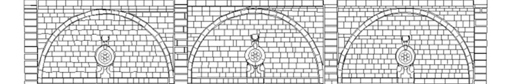
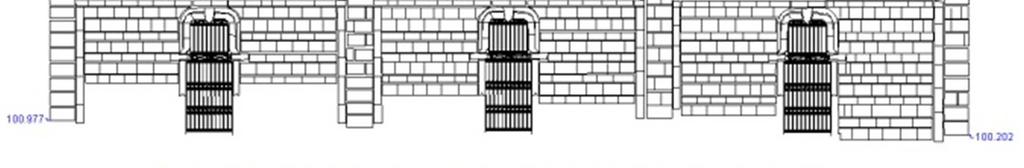
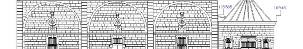
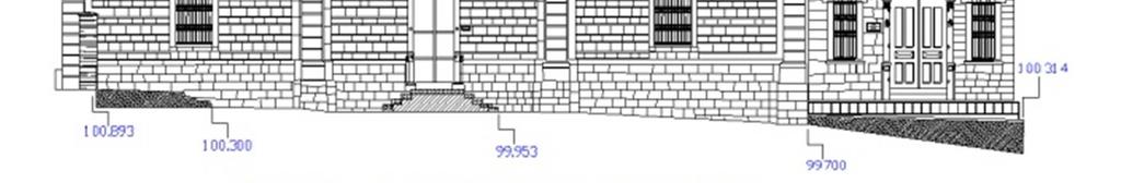

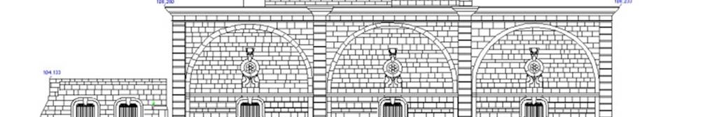
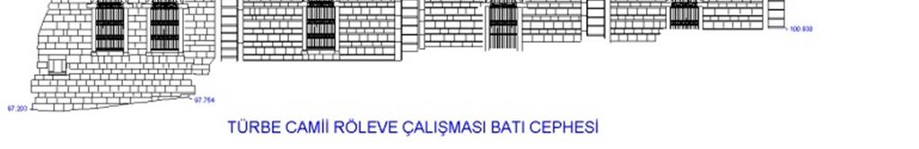
6 Figure 4 Façade drawings of Afyonkarahisar mevlevi lodge 6/6
7 4. CONCLUSIONS Most of the cultural heritages are lost or destroyed in the time. Conservation of cultural heritage and transferring them to future generations is important task. Close range photogrammetry is used for documentation of cultural heritage for many years. Close-range photogrammetry is very fast, powerful and reliable for documentation of cultural heritage. Digital close range photogrammetry is an important technique for documentation of cultural heritage. In this study, documentation of Afyonkarahisar Mevlevi lodge is presented. Façade drawings of Afyonkarahisar Mevlevi lodge were successfully obtained by the means of digital photogrammetry. Photomodeler software was used in this study. REFERENCES Atkinson, K.B., Close Range Photogrammetry and Machine Vision, Whittles Publishing, Scotland, 1996 Yastikli, N., Alkış, Z., Documentation of Cultural Heritage by Using Digital Close Range Photogrammetry, Proc. XIXth International Symposium CIPA 2003, New Perspective to Save Cultural Heritage, 30 September-04 October, pp , Antalya, Yakar, M., Yilmaz, H.M., Mutluoglu, O., Photogrammetric Measurement for the Kizil Kilise ( Red Church), FIG Working Week, June 2008, Stockholm, Sweden, Böhler W, Heinz G. Documentation, surveying, photogrammetry. XVII CIPA Symposium. Recife, Olinda. Brazil Available from Karabork, H., Yakar, M., Goktepe, A., Yildiz, F., Obtaining of Rolove for Some Historical Works of Art in the Ermenek (Karaman) Township by Photogrammetry, CIPA 2009 XXII International Symposium Digital Documentation, Interpretation & Presentation of Cultural Heritage, Kyoto, Japan, October 11-15, 2009 Scherer M. About the synthesis of different methods in surveying. XVIII International Symposium of CIPA, Potsdam, Germany, p URL-1, URL-2, 7/7
8 BIOGRAPHICAL NOTES Assistant Professor Dr. Murat UYSAL, was born in He graduated in 1995 as Dipl.-Ing. in Geodesy and Photogrammetry Engineering at Selcuk University. He obtained Msc degree in 1999 at Kocatepe University and obtained his doctorate degree in 2009 in Photogrammetry and Remote Sensing at Yildiz Technical University. He is since 2009 Assistant Professor of Engineering Faculty, Kocatepe University. Tamer BAYBURA was born in 1966 at Sulz am Neckar/Germany. In 1991 he graduated from The University of Selcuk; Department of Engineering and Architecture Faculty as a Geodesy and Photogrammetry Engineer. He finished his M.Sc. in 1994 at Graduate School of Natural and Applied Sciences that is within The University of Selcuk in Konya/Turkey. His PhD completed in 2001 at Graduate School of Natural and Applied Sciences that is within The Technical University of Istanbul. He worked as an research assistant in The University of Selcuk; Department of Engineering and Architecture Faculty between 1992 and Continuing from 2000, and current to date, he is working as Assistant Professor in Afyon Kocatepe University; Department of Engineering Faculty. Baybura has many studies on the area like highway and railway alignment geometry and deformation measurements and analysis. Ibrahim YILMAZ was born in 1970 at Afyonkarahisar, Turkey. In 1992 he graduated from The University of Selcuk; Department of Engineering and Architecture Faculty as a Geodesy and Photogrammetry Engineer. He finished his MSc in 1996 and completed his PhD in 2002 at Graduate School of Natural and Applied Sciences that is within The University of Selcuk. He worked as Research Assistant in The University of Selcuk; Department of Engineering and Architecture Faculty between 1992 and Continuing from 2002, and current to date, he is working as Assistant Professor in Afyon Kocatepe University; Department of Engineering Faculty. Yilmaz has many studies on the area like cartography, historical maps, georeferencing and colour science. CONTACTS Dr.Murat UYSAL Afyon Kocatepe University, Faculty of Engineering, Department of Surveying ANS Campus Gazlıgol Yolu,Afyonkarahisar Turkey Tel Fax muysal@aku.edu.tr Dr.Tamer BAYBURA Afyon Kocatepe University, Faculty of Engineering, Department of Surveying ANS Campus Gazlıgol Yolu,Afyonkarahisar Turkey 8/8
9 Tel Fax Dr.İbrahim YILMAZ Afyon Kocatepe University, Faculty of Engineering, Department of Surveying ANS Campus Gazlıgol Yolu,Afyonkarahisar Turkey Tel Fax /9
SAINT ANTHONY'S CHAPEL FAÇADE PATHOLOGY DOCUMENTATION
 SAINT ANTHONY'S CHAPEL FAÇADE PATHOLOGY DOCUMENTATION Mario Gardiol¹, Ana Maria Pighini² ¹ Associate Professor, Head of Photogrammetry Laboratory, UNL FICH. Pasaje Suarez 2631-3000 - Santa Fe - Argentina
Evaluation of Distortion Error with Fuzzy Logic
 Key Words: Distortion, fuzzy logic, radial distortion. SUMMARY Distortion can be explained as the occurring of an image at a different place instead of where it is required. Modern camera lenses are relatively
VISUALISATION OF UNDISCOVERED BOŘIVOJ II PRINCE TOMB INTERIOR AT THE PRAGUE CASTLE
 VISUALISATION OF UNDISCOVERED BOŘIVOJ II PRINCE TOMB INTERIOR AT THE PRAGUE CASTLE 1 Karel Pavelka, 2 Eva Štefanová, 3 Lena Halounová, 4 Martin Štroner 1 Head of Laboratory of Photogrammetry, Dept. Mapping
Desktop - Photogrammetry and its Link to Web Publishing
 Desktop - Photogrammetry and its Link to Web Publishing Günter Pomaska FH Bielefeld, University of Applied Sciences Bielefeld, Germany, email gp@imagefact.de Key words: Photogrammetry, image refinement,
Aerial photography: Principles. Frame capture sensors: Analog film and digital cameras
 Aerial photography: Principles Frame capture sensors: Analog film and digital cameras Overview Introduction Frame vs scanning sensors Cameras (film and digital) Photogrammetry Orthophotos Air photos are
CLOSE RANGE ORTHOIMAGE USING A LOW COST DIGITAL CAMCORDER
 CLOSE RANGE ORTHOIMAGE USING A LOW COST DIGITAL CAMCORDER E. Tsiligiris a, M. Papakosta a, C. Ioannidis b, A. Georgopoulos c a Surveying Engineer, Post-graduate Student, National Technical University of
AUTOMATED PROCESSING OF DIGITAL IMAGE DATA IN ARCHITECTURAL SURVEYING
 International Archives of Photogrammetry and Remote Sensing. Vol. XXXII, Part 5. Hakodate 1998 AUTOMATED PROCESSING OF DIGITAL IMAGE DATA IN ARCHITECTURAL SURVEYING Gunter Pomaska Prof. Dr.-lng., Faculty
KEY WORDS: Animation, Architecture, Image Rectification, Multi-Media, Texture Mapping, Visualization
 AUTOMATED PROCESSING OF DIGITAL IMAGE DATA IN ARCHITECTURAL SURVEYING Günter Pomaska Prof. Dr.-Ing., Faculty of Architecture and Civil Engineering FH Bielefeld, University of Applied Sciences Artilleriestr.
ATTEMPTS TO AUTOMATE THE PROCESS OF GENERATION OF ORTHOIMAGES OF OBJECTS OF CULTURAL HERITAGE
 ATTEMPTS TO AUTOMATE THE PROCESS OF GENERATION OF ORTHOIMAGES OF OBJECTS OF CULTURAL HERITAGE J.S. Markiewicz a*, P. Podlasiak a, D. Zawieska a a Faculty of Geodesy and Cartography, Institute of Photogrammetry,
PHOTOGRAMMETRIC-BASED SECURITY SYSTEM
 PHOTOGRAMMETRIC-BASED SECURITY SYSTEM Mohd Farid Mohd Ariff 1, Zulkepli Majid 1, Albert K. Chong 2 and Halim Setan 1 1 UTM-Photogrammetry and Laser Scanning Research Group, Universiti Teknologi Malaysia
SIMPLE METHODS FOR CLOSE RANGE PHOTOGRAMMETRY SURVEYING OF RURAL INDUSTRIAL CONSTRUCTIONS
 SIMPLE METHODS FOR CLOSE RANGE PHOTOGRAMMETRY SURVEYING OF RURAL INDUSTRIAL CONSTRUCTIONS P. Arias, H. Lorenzo, C. Ordoñez EUET Industrial, University of Vigo. r/ Torrecedeira 86, 36208-Vigo, Spain. Tlf.-
MINIMISING SYSTEMATIC ERRORS IN DEMS CAUSED BY AN INACCURATE LENS MODEL
 MINIMISING SYSTEMATIC ERRORS IN DEMS CAUSED BY AN INACCURATE LENS MODEL R. Wackrow a, J.H. Chandler a and T. Gardner b a Dept. Civil and Building Engineering, Loughborough University, LE11 3TU, UK (r.wackrow,
APPLICATION OF SPECTRAL AND TEXTURAL CLASSIFICATIONS TO RECOGNIZE MATERIALS AND DAMAGES ON HISTORIC BUILDING FACADES
 APPLICATION OF SPECTRAL AND TEXTURAL CLASSIFICATIONS TO RECOGNIZE MATERIALS AND DAMAGES ON HISTORIC BUILDING FACADES José Luis LERMA, Luis Ángel RUIZ, Fernando BUCHÓN Polytechnic University of Valencia,
COMPLEX DOCUMENTATION OF THE BRONZE EQUESTRIAN STATUE OF JAN ZIZKA BY USING PHOTOGRAMMETRY AND LASER SCANNING
 COMPLEX DOCUMENTATION OF THE BRONZE EQUESTRIAN STATUE OF JAN ZIZKA BY USING PHOTOGRAMMETRY AND LASER SCANNING K. Pavelka a, J. Reznicek b, B. Koska c a Head of Laboratory of Photogrammetry, Department
NON-METRIC BIRD S EYE VIEW
 NON-METRIC BIRD S EYE VIEW Prof. A. Georgopoulos, M. Modatsos Lab. of Photogrammetry, Dept. of Rural & Surv. Engineering, National Technical University of Athens, 9, Iroon Polytechniou, GR-15780 Greece
Assessment of Unmanned Aerial Vehicle for Management of Disaster Information
 Journal of the Korea Academia-Industrial cooperation Society Vol. 16, No. 1 pp. 697-702, 2015 http://dx.doi.org/10.5762/kais.2015.16.1.697 ISSN 1975-4701 / eissn 2288-4688 Assessment of Unmanned Aerial
NOTES. Institute of Engineering Surveying Department of Geomatics,
 AUTHORS ADDRESSES ADDRESSES of authors of articles in the Photogrammetric Record, 17(99), April 2002: James C. Adams, Clive S. Fraser, Institute of Engineering Surveying Department of Geomatics, and Space
Using the Photo-CD as a Digital Memory for Photogrammetric Images
 K. Hanke: Using the Photo-CD as a Digital Memory for Photogrammetric Images 1 Using the Photo-CD as a Digital Memory for Photogrammetric Images Klaus Hanke, Innsbruck Abstract The Photo-Compact Disk, introduced
Sample Copy. Not For Distribution.
 Photogrammetry, GIS & Remote Sensing Quick Reference Book i EDUCREATION PUBLISHING Shubham Vihar, Mangla, Bilaspur, Chhattisgarh - 495001 Website: www.educreation.in Copyright, 2017, S.S. Manugula, V.
The Most Suitable Sizes Of Ground Control Points (Gcps) For World View2
 For World View2") The Most Suitable Sizes Of Ground Control Points (Gcps) For World View2 Dr. O. Mutluoglu Dr.M. Yakar Dr. H.M. Yilmaz 1 INTRODUCTION High resolution satellite images, (less than 1 m. Resolution) are used
The Most Suitable Sizes Of Ground Control Points (Gcps) For World View2 Dr. O. Mutluoglu Dr.M. Yakar Dr. H.M. Yilmaz 1 INTRODUCTION High resolution satellite images, (less than 1 m. Resolution) are used
A SYSTEM FOR THE NORMAL CASE OF CLOSE-RANGE PHOTOGRAPHY WITH TERRESTRIAL CAMERA
 A SYSTEM FOR THE NORMAL CASE OF CLOSE-RANGE PHOTOGRAPHY WITH TERRESTRIAL CAMERA Oguz MÜFTÜOGLU - Cankut ÖRMEC! Surveying Department of Civil Engineering Faculty!stanbul Technical University,!stanbul -
Unmanned Aerial Vehicle Data Acquisition for Damage Assessment in. Hurricane Events
 Unmanned Aerial Vehicle Data Acquisition for Damage Assessment in Hurricane Events Stuart M. Adams a Carol J. Friedland b and Marc L. Levitan c ABSTRACT This paper examines techniques for data collection
0. Introduction 2 hours
 Lecture 0-1 _ February 2003 0. Introduction 2 hours History (analog, analytical, digital) Image information (physical, geometrical, semantic Literature Organizations Part 1 of 2 0.1. Definitions Photogrammetry
Technical information about PhoToPlan
 Technical information about PhoToPlan The following pages shall give you a detailed overview of the possibilities using PhoToPlan. kubit GmbH Fiedlerstr. 36, 01307 Dresden, Germany Fon: +49 3 51/41 767
MURAL PAINTING DIGITAL SURVEYS. Elena Murariu, private practice restorer, Bucharest, Romania Florian Petrescu, GEOSYSTEMS Romania, Bucharest, Romania
 MURAL PAINTING DIGITAL SURVEYS Elena Murariu, private practice restorer, Bucharest, Romania Florian Petrescu, GEOSYSTEMS Romania, Bucharest, Romania str. Roma 8, sector 1, 71219 Bucharest, Romania, e-mail:
PERSPECTIVE VIEWS AND PANORAMAS IN PRESENTATION OF RELIEF FORMS IN POLAND
 PERSPECTIVE VIEWS AND PANORAMAS IN PRESENTATION OF RELIEF FORMS IN POLAND Waldemar Rudnicki Institute of Geodesy and Cartography, ul. Modzelewskiego 27, 02 679 Warsaw, Poland Tel: +48 22 3291993, Fax:
SURVEY AND REPRESENTATION METHODOLOGIES IN TEACHING EXPERIENCE
 SURVEY AND REPRESENTATION METHODOLOGIES IN TEACHING EXPERIENCE E. Agosto (*), S. Coppo (**), A. Osello (**), F. Rinaudo (*) (*) DITAG, Politecnico di Torino, Corso duca degli Abruzzi, 24 10129 Torino,
SCIENCE & TECHNOLOGY
 Pertanika J. Sci. & Technol. 21 (2): 387-396 (2013) SCIENCE & TECHNOLOGY Journal homepage: http://www.pertanika.upm.edu.my/ Production of Orthophoto and Volume Determination Using Low-Cost Digital Cameras
Modern Methods for using Single Images in Conservation. by Walter Schuhr and Erich Kanngieser. for Applied Sciences for Applied Sciences
 Modern Methods for using Single Images in Conservation by Walter Schuhr and Erich Kanngieser University University for Applied Sciences for Applied Sciences Magdeburg Hamburg e-mail:schuhr3d@hotmail.com
CSI: Rombalds Moor Photogrammetry Photography
 Photogrammetry Photography Photogrammetry Training 26 th March 10:00 Welcome Presentation image capture Practice 12:30 13:15 Lunch More practice 16:00 (ish) Finish or earlier What is photogrammetry 'photo'
Technology Accreditation Canada (TAC) SURVEY/GEOMATICS TECHNOLOGY TECHNOLOGIST Canadian Technology Accreditation Criteria (CTAC)
 SURVEY/GEOMATICS TECHNOLOGY TECHNOLOGIST Canadian Technology Accreditation Criteria (CTAC)") Technology Accreditation Canada (TAC) SURVEY/GEOMATICS TECHNOLOGY TECHNOLOGIST Canadian Technology Accreditation Criteria (CTAC) Preamble These CTAC are applicable to programs having titles involving Survey/Geomatics
Technology Accreditation Canada (TAC) SURVEY/GEOMATICS TECHNOLOGY TECHNOLOGIST Canadian Technology Accreditation Criteria (CTAC) Preamble These CTAC are applicable to programs having titles involving Survey/Geomatics
HD aerial video for coastal zone ecological mapping
 HD aerial video for coastal zone ecological mapping Albert K. Chong University of Otago, Dunedin, New Zealand Phone: +64 3 479-7587 Fax: +64 3 479-7586 Email: albert.chong@surveying.otago.ac.nz Presented
AN AUTOMATIC PROCESS FOR THE EXTRACTION OF THE 3D MODEL OF THE HUMAN BACK SURFACE FOR SCOLIOSIS TREATMENT
 AN AUTOMATIC PROCESS FOR THE EXTRACTION OF THE 3D MODEL OF THE HUMAN BACK SURFACE FOR SCOLIOSIS TREATMENT Lazaros SECHIDIS, Vassilios TSIOUKAS, Petros PATIAS The Aristotle University of Thessaloniki Department
switzerland Commission II, ISPRS Kyoto, July 1988
 TOWARDS THE DIGITAL FUTURE stefan Lutz Kern & CO.., Ltd 5000 Aarau switzerland Commission II, ISPRS Kyoto, July 1988 ABSTRACT The equipping of the Kern Digital stereo Restitution Instrument (DSR) with
D. Hunter, J. Smart Kern & Co.., Ltd 5000 Aarau switzerland Commission II, ISPRS Kyoto, July 1988
 IMAGE ORIENTATION ON THE KERN DSR D. Hunter, J. Smart Kern & Co.., Ltd 5000 Aarau switzerland Commission II, ISPRS Kyoto, July 1988 Abstract A description of the possible image orientation capabilities
AERIAL SURVEY TEST PROJECT WITH DJI PHANTOM 3 QUADROCOPTER DRONE
 T. Jancso, P. Engler, P. Udvardy Aerial Survey Test Project with DJI Phantom 3 Quadrocopter Drone AERIAL SURVEY TEST PROJECT WITH DJI PHANTOM 3 QUADROCOPTER DRONE Tamas JANCSO, Associate Professor Phd
A FEASIBLE METHODOLOGY FOR THE USE OF CLOSE RANGE PHOTOGRAMMETRY FOR THE RECORDING OF ARCHAEOLOGICAL EXCAVATIONS
 A FEASIBLE METHODOLOGY FOR THE USE OF CLOSE RANGE PHOTOGRAMMETRY FOR THE RECORDING OF ARCHAEOLOGICAL EXCAVATIONS F. Tack a, J. Debie b, R. Goossens a, J. De Meulemeester c, D. Devriendt a a Ghent University,
FROM METRIC IMAGE ARCHIVES TO POINT CLOUD RECONSTRUCTION: CASE STUDY OF THE GREAT MOSQUE OF ALEPPO IN SYRIA
 FROM METRIC IMAGE ARCHIVES TO POINT CLOUD RECONSTRUCTION: CASE STUDY OF THE GREAT MOSQUE OF ALEPPO IN SYRIA P. Grussenmeyer a, O. Al Khalil b a Photogrammetry and Geomatics Group, ICube Laboratory UMR
Investigating the Movements of Bosporus Bridge by Different Types of Loads
 Investigating the Movements of Bosporus Bridge by Different Types of Loads Hediye ERDOĞAN, Burak AKPINAR, V.Engin GÜLAL, Ercenk. ATA, Turkey Key words: Bridge Surveying, Bosporus Bridge, RTK GPS, Fast
Commission 6 Engineering Surveys Work Plan
 Appendix to item 21.6 Commission 6 Engineering Surveys Work Plan 2007 2010 1. Title Engineering Surveys 2. Terms of reference - Acquisition, processing and management of topometric data and all related
INSERTING THE PAST IN VIDEO SEQUENCES
 INSERTING THE PAST IN VIDEO SEQUENCES Elli Petsa, Stefanos Kouroupis Department of Surveying, Technological Educational Institute of Athens GR-12210 Athens, Greece (e-mail: petsa@teiath.gr) George Karras
MODERN PROCESSING CAPABILITIES OF ANALOG DATA FROM DOCUMENTATION OF THE GREAT OMAYYAD MOSQUE IN ALEPPO, SYRIA, DAMAGED IN CIVIL WAR
 MODERN PROCESSING CAPABILITIES OF ANALOG DATA FROM DOCUMENTATION OF THE GREAT OMAYYAD MOSQUE IN ALEPPO, SYRIA, DAMAGED IN CIVIL WAR K.Pavelka a, J.Šedina a, P.Raeva a, M. Hůlková a a Czech Technical University
DETERMINATION OF ST. GEORGE BASILICA TOWER HISTORICAL INCLINATION FROM CONTEMPORARY PHOTOGRAPH
 DETERMINATION OF ST. GEORGE BASILICA TOWER HISTORICAL INCLINATION FROM CONTEMPORARY PHOTOGRAPH Bronislav KOSKA 1 1 Czech Technical University in Prague, Faculty of Civil Engineering Thákurova 7, Prague
OVERVIEW OF KOMPSAT-3A CALIBRATION AND VALIDATION
 OVERVIEW OF KOMPSAT-3A CALIBRATION AND VALIDATION DooChun Seo 1, GiByeong Hong 1, ChungGil Jin 1, DaeSoon Park 1, SukWon Ji 1 and DongHan Lee 1 1 KARI(Korea Aerospace Space Institute), 45, Eoeun-dong,
DEVELOPMENT OF IMAGE-BASED INFORMATION SYSTEM FOR RESTORATION OF CULTURAL HERITAGE
 Hongo, Kenji DEVELOPMENT OF IMAGE-BASED INFORMATION SYSTEM FOR RESTORATION OF CULTURAL HERITAGE Kenji Hongo*, Ryuji Matsuoka*, Seiju Fujiwara*, Katsuhiko Masuda** and Shigeo Aoki** * Kokusai Kogyo Co.,
INFORMATION CONTENT ANALYSIS FROM VERY HIGH RESOLUTION OPTICAL SPACE IMAGERY FOR UPDATING SPATIAL DATABASE
 INFORMATION CONTENT ANALYSIS FROM VERY HIGH RESOLUTION OPTICAL SPACE IMAGERY FOR UPDATING SPATIAL DATABASE M. Alkan a, * a Department of Geomatics, Faculty of Civil Engineering, Yıldız Technical University,
APPLICATION OF PHOTOGRAMMETRY TO BRIDGE MONITORING
 APPLICATION OF PHOTOGRAMMETRY TO BRIDGE MONITORING Jónatas Valença, Eduardo Júlio, Helder Araújo ISR, University of Coimbra, Portugal jonatas@dec.uc.pt, ejulio@dec.uc.pt, helder@isr.uc.pt KEYWORDS: Photogrammetry;
ON THE CREATION OF PANORAMIC IMAGES FROM IMAGE SEQUENCES
 ON THE CREATION OF PANORAMIC IMAGES FROM IMAGE SEQUENCES Petteri PÖNTINEN Helsinki University of Technology, Institute of Photogrammetry and Remote Sensing, Finland petteri.pontinen@hut.fi KEY WORDS: Cocentricity,
OUR INDUSTRIAL LEGACY WHAT ARE WE LEAVING OUR CHILDREN REAAA Roadshow Taupo, August 2016 Young presenter s competition
 OUR INDUSTRIAL LEGACY WHAT ARE WE LEAVING OUR CHILDREN Preserving the country s aerial photography archive for future generations Abstract For over eighty years, aerial photography has captured the changing
Cors Networks And Investigation Of Point Positioning Accuracy Of Konya Permanent GNSS Network (Kosaga)
") Cors Networks And Investigation Of Point Positioning Accuracy Of Konya Permanent GNSS Network (Kosaga) Ayhan CEYLAN, Turkey Key words: GNSS, Cors-Tr, Kosaga SUMMARY Mankind has always wondered where it
Cors Networks And Investigation Of Point Positioning Accuracy Of Konya Permanent GNSS Network (Kosaga) Ayhan CEYLAN, Turkey Key words: GNSS, Cors-Tr, Kosaga SUMMARY Mankind has always wondered where it
Technical Evaluation of Khartoum State Mapping Project
 Technical Evaluation of Khartoum State Mapping Project Nagi Zomrawi 1 and Mohammed Fator 2 1 School of Surveying Engineering, Collage of Engineering, Sudan University of Science and Technology, Khartoum,
High Resolution Imaging for DMLS Inspection
 High Resolution Imaging for DMLS Inspection Institute of Imaging and Computer Vision RWTH Aachen University Germany 1 Agenda The BIGS Research Project Image Acquisition Setup Application Example: Material
DIGITAL BUILDING HERITAGE GROUP. Recreating the past to preserve our future
 DIGITAL BUILDING HERITAGE GROUP Recreating the past to preserve our future CONTENTS Imagine the possibilities 3-4 A passion for the past 5-6 Helping to tell your stories 7-8 Case studies 9-12 Study with
Tutorial 10 Information extraction from high resolution optical satellite sensors
 Tutorial 10 Information extraction from high resolution optical satellite sensors Karsten Jacobsen 1, Emmanuel Baltsavias 2, David Holland 3 1 University of, Nienburger Strasse 1, D-30167, Germany, jacobsen@ipi.uni-hannover.de
DIGITAL TECHNOLOGY IN THE DOCUMENTATION AND CONSERVATION OF CULTURAL MONUMENTS
 POSTER SESSIONS 217 Abstract DIGITAL TECHNOLOGY IN THE DOCUMENTATION AND CONSERVATION OF CULTURAL MONUMENTS Clifford L. Ogleby Department of Geomatics The University of Melbourne Parkville. 3052. A~stralia
Digital Image Processing
 Digital Image Processing 1 Patrick Olomoshola, 2 Taiwo Samuel Afolayan 1,2 Surveying & Geoinformatic Department, Faculty of Environmental Sciences, Rufus Giwa Polytechnic, Owo. Nigeria Abstract: This paper
Author manuscript, published in "XXth Congress of the International Society for Photogrammetry and Remote Sensing (ISPRS), Istanbul : Turkey (2004)"
, Istanbul : Turkey (2004)") Author manuscript, published in "XXth Congress of the International Society for Photogrammetry and Remote Sensing (ISPRS), Istanbul : Turkey (2004)" PHOTOGRAMMETRY FOR THE PREPARATION OF ARCHAEOLOGICAL
Author manuscript, published in "XXth Congress of the International Society for Photogrammetry and Remote Sensing (ISPRS), Istanbul : Turkey (2004)" PHOTOGRAMMETRY FOR THE PREPARATION OF ARCHAEOLOGICAL
VERIFICATION OF POTENCY OF AERIAL DIGITAL OBLIQUE CAMERAS FOR AERIAL PHOTOGRAMMETRY IN JAPAN
 VERIFICATION OF POTENCY OF AERIAL DIGITAL OBLIQUE CAMERAS FOR AERIAL PHOTOGRAMMETRY IN JAPAN Ryuji. Nakada a, *, Masanori. Takigawa a, Tomowo. Ohga a, Noritsuna. Fujii a a Asia Air Survey Co. Ltd., Kawasaki
Calibration Report. Short Version. UltraCam L, S/N UC-L Vexcel Imaging GmbH, A-8010 Graz, Austria
 Calibration Report Short Version Camera: Manufacturer: UltraCam L, S/N UC-L-1-00612089 Vexcel Imaging GmbH, A-8010 Graz, Austria Date of Calibration: Mar-23-2010 Date of Report: May-17-2010 Camera Revision:
Karlskirche IVR, a questionnaire on a VR user experience
 Karlskirche IVR, a questionnaire on a VR user experience Michael Klein (7reasons, Austria), Martin Schaich (Arctron, Germany), Wolfgang Sovis (WU, Austria), Barbara Fink (WU, Austria), Thomas Reutterer
THE ERATO PROJECT AND ITS CONTRIBUTION TO OUR UNDERSTANDING OF THE ACOUSTICS OF ANCIENT THEATRES
 THE ERATO PROJECT AND ITS CONTRIBUTION TO OUR UNDERSTANDING OF THE ACOUSTICS OF ANCIENT THEATRES Jens Holger Rindel Odeon A/S, Scion-DTU, DK 2800 Kgs. Lyngby, Denmark e-mail: jhr@odeon.dk Abstract The
RESEARCH ON LOW ALTITUDE IMAGE ACQUISITION SYSTEM
 RESEARCH ON LOW ALTITUDE IMAGE ACQUISITION SYSTEM 1, Hongxia Cui, Zongjian Lin, Jinsong Zhang 3,* 1 Department of Information Science and Engineering, University of Bohai, Jinzhou, Liaoning Province,11,
Graduate in Food Engineering. Program Educational Objectives and Student Outcomes
 1. Program Educational Objectives and Student Outcomes A graduate in Food Engineering is a professional specially trained to plan design and implementation of projects and production processes in the food
PERFORMANCE EVALUATIONS OF MACRO LENSES FOR DIGITAL DOCUMENTATION OF SMALL OBJECTS
 PERFORMANCE EVALUATIONS OF MACRO LENSES FOR DIGITAL DOCUMENTATION OF SMALL OBJECTS ideharu Yanagi a, Yuichi onma b, irofumi Chikatsu b a Spatial Information Technology Division, Japan Association of Surveyors,
APPLICATION OF STRUCTURE FROM MORTION IN JAPANESE ARCHAEOLOGY
 APPLICATION OF STRUCTURE FROM MORTION IN JAPANESE ARCHAEOLOGY Akihiro Kaneda A, *, Yama Ahmad Nawabi B, Hiroshi Yamaguchi C. A Nara National Research Institute for Cultural Properties, Center for Archaeological
CHAPTER 144. Interpretation of Shoreline Position from Aerial Photographs John S. Fisher 1 Margery F. Overton 2
 CHAPTER 144 Interpretation of Shoreline Position from Aerial Photographs John S. Fisher 1 Margery F. Overton 2 Abstract A review of some of the potential sources of error associated with the use of aerial
14 th Congress of the International Society of Photogrammetry Hamburg Commission V. Presented Paper
 14 th Congress of the International Society of Photogrammetry Hamburg 1980 Commission V Presented Paper Prof.Dr.Habil. Zbigniew SITEK University of Mining and Metallurgy Krakow, Poland CHECKING OF PHOTOGRAMMETRIC
PHOTOMOD Lite Project Contest
 PHOTOMOD Lite Project Contest Nomination: Education with PHOTOMOD Lite Institute name: Laboratory of Photogrammetry, School of Rural and Surveying Engineer, National Technical University of Athens Address:
A New Capability for Crash Site Documentation
 A New Capability for Crash Site Documentation By Major Adam Cybanski, Directorate of Flight Safety, Ottawa Major Adam Cybanski is the officer responsible for helicopter investigation (DFS 2-4) at the Canadian
STUDYING THE EFFECT OF SOME IMAGE ENHANCEMENT FEATURES ON THE ACCURACY OF CLOSE RANGE PHOTOGRAMMETRIC MEASUREMENTS USING CAD ENVIRONMENT
 STUDYING THE EFFECT OF SOME IMAGE ENHANCEMENT FEATURES ON THE ACCURACY OF CLOSE RANGE PHOTOGRAMMETRIC MEASUREMENTS USING CAD ENVIRONMENT M. A.-B. Ebrahim Lecturer at Civil Engineering Department, Faculty
DIFFERENTIAL APPROACH FOR MAP REVISION FROM NEW MULTI-RESOLUTION SATELLITE IMAGERY AND EXISTING TOPOGRAPHIC DATA
 DIFFERENTIAL APPROACH FOR MAP REVISION FROM NEW MULTI-RESOLUTION SATELLITE IMAGERY AND EXISTING TOPOGRAPHIC DATA Costas ARMENAKIS Centre for Topographic Information - Geomatics Canada 615 Booth Str., Ottawa,
Volume 1 - Module 6 Geometry of Aerial Photography. I. Classification of Photographs. Vertical
 RSCC Volume 1 Introduction to Photo Interpretation and Photogrammetry Table of Contents Module 1 Module 2 Module 3.1 Module 3.2 Module 4 Module 5 Module 6 Module 7 Module 8 Labs Volume 1 - Module 6 Geometry
Determining Crash Data Using Camera Matching Photogrammetric Technique
 SAE TECHNICAL PAPER SERIES 2001-01-3313 Determining Crash Data Using Camera Matching Photogrammetric Technique Stephen Fenton, William Neale, Nathan Rose and Christopher Hughes Knott Laboratory, Inc. Reprinted
EXPERIENCES AND PROCEDURES ON MAKING TECHNICAL DOCUMENTATION FOR THE OBJECTS OF HISTORICAL AND CULTURAL HERITAGE
 EXPERIENCES AND PROCEDURES ON MAKING TECHNICAL DOCUMENTATION FOR THE OBJECTS OF HISTORICAL AND CULTURAL HERITAGE D. Kukolj a,, D. Mihajlovic b, I. Nedeljkovic a a MAPSOFT Ltd, Zahumska 26, Belgrade, Serbia
Tree Age Estimation by Tree Diameter Measurement using Digital Close Range Photogrammetry (DCRP)
") Tree Age Estimation by Tree Diameter Measurement using Digital Close Range Photogrammetry (DCRP) Muhd Safarudin Chek Mat *1, Mohammad Asyraf Mohd Nor *1, Jezan Md Diah #2, Mokhtar Azizi Mohd Din #3, Khairil
Tree Age Estimation by Tree Diameter Measurement using Digital Close Range Photogrammetry (DCRP) Muhd Safarudin Chek Mat *1, Mohammad Asyraf Mohd Nor *1, Jezan Md Diah #2, Mokhtar Azizi Mohd Din #3, Khairil
Overview. Objectives. The ultimate goal is to compare the performance that different equipment offers us in a photogrammetric flight.
 Overview At present, one of the most commonly used technique for topographic surveys is aerial photogrammetry. This technique uses aerial images to determine the geometric properties of objects and spatial
AUTOMATED PAVEMENT IMAGING PROGRAM (APIP) FOR PAVEMENT CRACKS CLASSIFICATION AND QUANTIFICATION A PHOTOGRAMMETRIC APPROACH
 FOR PAVEMENT CRACKS CLASSIFICATION AND QUANTIFICATION A PHOTOGRAMMETRIC APPROACH") AUTOMATED PAVEMENT IMAGING PROGRAM (APIP) FOR PAVEMENT CRACKS CLASSIFICATION AND QUANTIFICATION A PHOTOGRAMMETRIC APPROACH M. Mustaffar a*, T. C. Ling b, O. C. Puan b a Surveying Unit, Faculty of Civil
AUTOMATED PAVEMENT IMAGING PROGRAM (APIP) FOR PAVEMENT CRACKS CLASSIFICATION AND QUANTIFICATION A PHOTOGRAMMETRIC APPROACH M. Mustaffar a*, T. C. Ling b, O. C. Puan b a Surveying Unit, Faculty of Civil
Calibration Report. Short version. UltraCam Xp, S/N UC-SXp Vexcel Imaging GmbH, A-8010 Graz, Austria
 Calibration Report Short version Camera: Manufacturer: UltraCam Xp, S/N UC-SXp-1-61212452 Vexcel Imaging GmbH, A-8010 Graz, Austria Date of Calibration: Mar-05-2009 Date of Report: Mar-13-2009 Camera Revision:
High Resolution Sensor Test Comparison with SPOT, KFA1000, KVR1000, IRS-1C and DPA in Lower Saxony
 High Resolution Sensor Test Comparison with SPOT, KFA1000, KVR1000, IRS-1C and DPA in Lower Saxony K. Jacobsen, G. Konecny, H. Wegmann Abstract The Institute for Photogrammetry and Engineering Surveys
Calibration Report. Short Version. Vexcel Imaging GmbH, A-8010 Graz, Austria
 Calibration Report Short Version Camera: Manufacturer: UltraCam D, S/N UCD-SU-2-0039 Vexcel Imaging GmbH, A-8010 Graz, Austria Date of Calibration: Mar-14-2011 Date of Report: Mar-17-2011 Camera Revision:
Calibration Report. Short Version. UltraCam Eagle, S/N UC-E f210. Vexcel Imaging GmbH, A-8010 Graz, Austria
 Calibration Report Short Version Camera: Manufacturer: Date of Calibration: Date of Report: Revision of Camera: Version of Report: UltraCam Eagle, S/N UC-E-1-00518105-f210 Vexcel Imaging GmbH, A-8010 Graz,
INVESTIGATION OF PHOTOTRIANGULATION ACCURACY WITH USING OF VARIOUS TECHNIQUES LABORATORY AND FIELD CALIBRATION
 INVESTIGATION OF PHOTOTRIANGULATION ACCURACY WITH USING OF VARIOUS TECHNIQUES LABORATORY AND FIELD CALIBRATION A. G. Chibunichev 1, V. M. Kurkov 1, A. V. Smirnov 1, A. V. Govorov 1, V. A. Mikhalin 2 *
Using Low Cost DeskTop Publishing (DTP) Scanners for Aerial Photogrammetry
 Scanners for Aerial Photogrammetry") Journal of Geosciences and Geomatics, 21, Vol. 2, No., 17- Available online at http://pubs.sciepub.com/jgg/2//5 Science and Education Publishing DOI:1.12691/jgg-2--5 Using Low Cost DeskTop Publishing (DTP)
Journal of Geosciences and Geomatics, 21, Vol. 2, No., 17- Available online at http://pubs.sciepub.com/jgg/2//5 Science and Education Publishing DOI:1.12691/jgg-2--5 Using Low Cost DeskTop Publishing (DTP)
CALIBRATION OF AN AMATEUR CAMERA FOR VARIOUS OBJECT DISTANCES
 CALIBRATION OF AN AMATEUR CAMERA FOR VARIOUS OBJECT DISTANCES Sanjib K. Ghosh, Monir Rahimi and Zhengdong Shi Laval University 1355 Pav. Casault, Laval University QUEBEC G1K 7P4 CAN A D A Commission V
Panorama Photogrammetry for Architectural Applications
 Panorama Photogrammetry for Architectural Applications Thomas Luhmann University of Applied Sciences ldenburg Institute for Applied Photogrammetry and Geoinformatics fener Str. 16, D-26121 ldenburg, Germany
How we build reality. Company Overview. The value of 3D data for restoration purposes The Mack - Mackintosh Building
 How we build reality The value of 3D data for restoration purposes The Mack - Mackintosh Building Case Study Glasgow, Scotland Company Overview Z+F is one of the world s leading manufacturers in the fi
THE METRIC DOCUMENTATION OF VILLA POIANA BY ANDREA PALLADIO WITH SPHERICAL PHOTOGRAMMETRY
 22nd CIPA Symposium, October 11-15, 29, Kyoto, Japan THE METRIC DOCUMENTATION OF VILLA POIANA BY ANDREA PALLADIO WITH SPHERICAL PHOTOGRAMMETRY P. Clini, G. Fangi p.clini@univm.it g.fangi@univpm.it Dardus,
INFORMATION CONTENT ANALYSIS OF KVR-1000 ORTHO-IMAGE BASED ON THE AVAILABLE TOPOGRAPHIC MAPS IN THE GIS ENVIRONMENT
 EARSEL Workshop on Remote Sensing for Developing Countries, Cairo, 2004 1 INFORMATION CONTENT ANALYSIS OF KVR-1000 ORTHO-IMAGE BASED ON THE AVAILABLE TOPOGRAPHIC MAPS IN THE GIS ENVIRONMENT H. Sahin, G.
Outline Remote Sensing Defined Resolution Electromagnetic Energy (EMR) Types Interpretation Applications
 Types Interpretation Applications") Introduction to Remote Sensing Outline Remote Sensing Defined Resolution Electromagnetic Energy (EMR) Types Interpretation Applications Remote Sensing Defined Remote Sensing is: The art and science of
Introduction to Remote Sensing Outline Remote Sensing Defined Resolution Electromagnetic Energy (EMR) Types Interpretation Applications Remote Sensing Defined Remote Sensing is: The art and science of
DETAILED RESTITUTION AND REPRESENTATION OF THE SEAWARD CASTLE OF CHIOS
 DETAILED RESTITUTION AND REPRESENTATION OF THE SEAWARD CASTLE OF CHIOS C. IOANNIDIS (1), C. POTSIOU (2) (1) Lecturer, School of Rural and Surveying Engineering, Lab. of Photogrammetry, National Technical
Services Overview. Northeast Blueprint
 Services Overview 2D CAD Conversions Paper to CAD 2D CAD Conversions Construction Engineering / CAD Services Construction Markups Consultant Drawings Coordinated Drawings As -Builts Steel Structural Detailing
Leica Viva Image Assisted Surveying & Image Notes
 Leica Viva Image Assisted Surveying & Image Notes Contents 1. Introduction 3. Image Notes 4. Availability 5. Summary 1. Introduction Image Assisted Surveying Camera live view of what the total station
The 3D Documentation of Al-Jahili Fort in Al-Ain, United Arab Emirates (UAE): A Virtual Reality Application
: A Virtual Reality Application") The 3D Documentation of Al-Jahili Fort in Al-Ain, United Arab Emirates (UAE): A Virtual Reality Application Ihab Nabil Elkhawas, M.Sc.Arch, MCRP, Ph.D. And Amal Abdullah Al Qubaisi, MPhil.Arch, Ph.D. Assistant
The 3D Documentation of Al-Jahili Fort in Al-Ain, United Arab Emirates (UAE): A Virtual Reality Application Ihab Nabil Elkhawas, M.Sc.Arch, MCRP, Ph.D. And Amal Abdullah Al Qubaisi, MPhil.Arch, Ph.D. Assistant
A DETAILED GEOMETRIC DOCUMENTATION OF THE ATHENS ACADEMY PUBLIC MEETING HALL
 A DETAILED GEOMETRIC DOCUMENTATION OF THE ATHENS ACADEMY PUBLIC MEETING HALL D. Balodimos (a), S. Dogouris (a), A. Georgopoulos (b), Ch. Ioannidis (b), S. Soile (b), M. Tsilikis (c) (a) Laboratory of General
products PC Control
 products PC Control 04 2017 PC Control 04 2017 products Image processing directly in the PLC TwinCAT Vision Machine vision easily integrated into automation technology Automatic detection, traceability
Inventory of the Bernard Warshaw Holocaust Atrocity Photographs, , circa 2000
 Inventory of the Bernard Warshaw Holocaust Atrocity Photographs, 1942-1945, circa 2000 Addlestone Library, Special Collections College of Charleston 66 George Street Charleston, SC 29424 USA http://archives.library.cofc.edu
A Report on the ISPRS Commission V 2010 Symposium Close-Range Imaging & Measuring Techniques
 A Report on the ISPRS Commission V 2010 Symposium Close-Range Imaging & Measuring Techniques Close-range non-topographic photogrammetry used to form a very minor part of the overall science of photogrammetry.
Camera Calibration PhaseOne 80mm Lens A & B. For Jamie Heath Terrasaurus Aerial Photography Ltd.
 Camera Calibration PhaseOne 80mm Lens A & B For Jamie Heath Terrasaurus Aerial Photography Ltd. Page 2 PhaseOne with 80mm lens PhaseOne with 80mm lens Table of Contents Executive Summary 5 Camera Calibration
Camera Calibration Certificate No: DMC II
 Calibration DMC II 230 015 Camera Calibration Certificate No: DMC II 230 015 For Air Photographics, Inc. 2115 Kelly Island Road MARTINSBURG WV 25405 USA Calib_DMCII230-015_2014.docx Document Version 3.0
Time-Lapse Panoramas for the Egyptian Heritage
 Time-Lapse Panoramas for the Egyptian Heritage Mohammad NABIL Anas SAID CULTNAT, Bibliotheca Alexandrina While laser scanning and Photogrammetry has become commonly-used methods for recording historical