Land Use Change Detection Using Satellite Imagery
|
|
|
- Ferdinand Carr
- 6 years ago
- Views:
Transcription


1 Land Use Change Detection Using Satellite Imagery Chi-Farn Chen Center for Space and Remote Sensing Research National Central University TAIWAN Tel : Fax : cfchen@csrsr.ncu.edu.tw 1

2 Land cover / Land use Change Detection in Taiwan TAIWAN Area: 36,000 sq km Landscape: 2/3 are mountains and hills Population: 23,000,000, 90% reside in west coastal plants 2
3 Land cover / Land use Change Detection in Taiwan Illegal activities of land use is inevitable. Land use monitoring heavily depends on patrolmen that is labor-intensive and inefficient for a large-scale operation. For the purpose of sustainable development, the government becomes aware of that the land use management needs the aid of remote sensing technology. 3

4 Land cover / Land use Change Detection in Taiwan A joint project to monitor the land use has been conducted by : Center for Space and Remote Sensing Research National Central University National Land Surveying and Mapping Center Ministry of Interior ( 整合營建署 水利署 水保局土地利用監測的業務 ) 4
5 Land cover / Land use Change Detection in Taiwan The system integrates multi-temporal images with GIS The main objective is to use the remote sensing images to detect the land use changes every two month on a national scale. 5
6 FORMOSAT-2 Satellite Satellite Spectral Range Resolution Period Coverage Height FS-2 (μm) (m) (day) (km 2 ) (km) Multispectral 1.B G R NIR daily 24 X Panchromatic
7 FORMOSAT-2 Orbits over Taiwan 7
8 SPOT Satellite Satellite Spectral Range Resolution Period Coverage Height SPOT 5 (μm) (m) (day) (km 2 ) (km) Multispectral 1.G R NIR SWIR / X Panchromatic /2.5 8
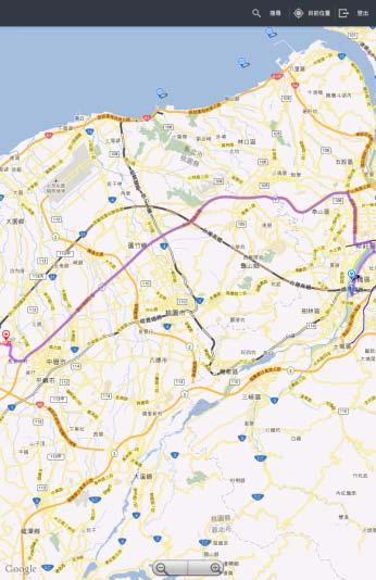
9 SPOT Orbits over Taiwan 9

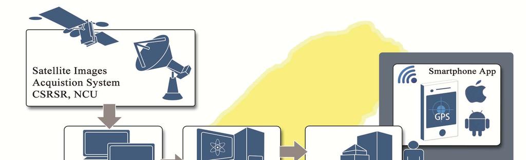
10 Multi-temporal Images Image at Time 1 Image at Time 2 1. the detection of changes 2. the notification of change information 3. the field investigation of change spots 10
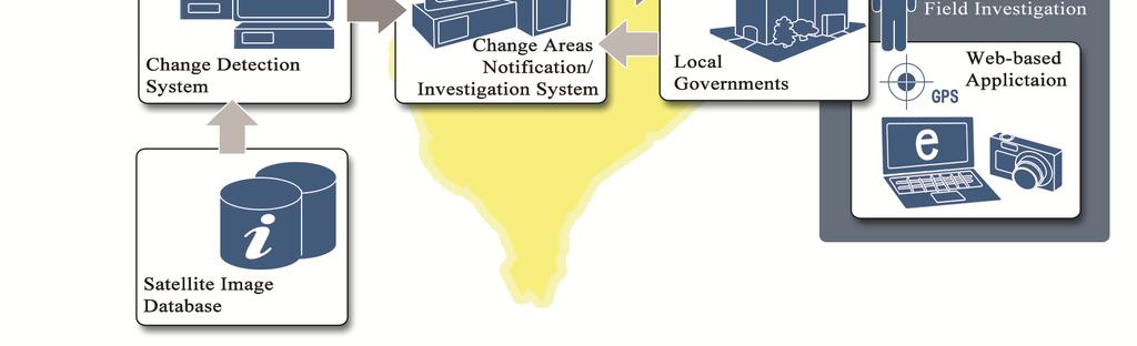
11 Infrastructure The system basically consists of three sub-systems: Land Change Detection System Web-based Land Change Reporting System Digital Field Investigation System 11
12 Infrastructure 12

13 Land Change Detection System Basic DIP functions Change detection capability Editing functions Output 13


14 Land Change Detection System FUNCTIONS SYSTEM MANAGEMENT OPERATION SETTING IMAGE MANAGEMENT BATCH LAYOUT STATISTICS 14

15 Land Change Detection System 5400 map frames with scale of 1/
16 Image Pre-Processing Image Acquisition Raw Image Image Catalogue Level-1A Image Ortho-Rectified Image (Level-4) Fusion of XS and PAN Registration of Multi-temporal images 16

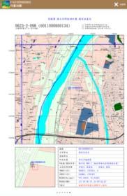
17 Land Change Detection System Change detection:1. computer processing Threshold of Histogram Matching Change Detection Using Histogram Matching(HM) 17


18 Land Change Detection System Image at Time 1 Image at Time 2 HM Result of Image at Time 2 White Areas are the Changes 18

19 Land Change Detection System Change detection:2. manual editing (with supplementary GIS data : land use map, topo. maps with differential scales, aerial photos, etc.) 19


20 Land Change Detection System The supplementary GIS data used for manual editing Land use map 1/5,000 Topo. map 1/25,000 Topo. map Slop map Aerial photo Land development permitted map 20 20


21 Land Change Detection System Computer Processing Manual Editing Aerial Photo Land Use Map Tour Guide Map Land change inside the campus of a college NO notification 21


22 Land Change Detection System Computer Processing Manual Editing Aerial Photo Land Use Map Tour Guide Map Land development in the farm land Notification 22

23 Land Change Detection System End editing 23
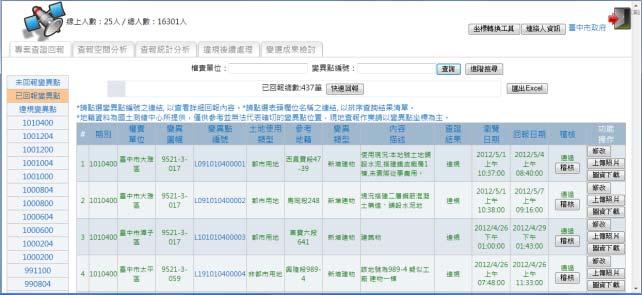
24 Land Change Detection System Output based on 1/5000 scale map 5400 map frames with scale of 1/

25 Land Change Detection System Output Change spot on Image at Time 1 Change spot on Image at Time 2 25


26 Land Change Detection System Output Digital map Aerial photo Change spot 26

27 Land Change Detection System Output Change spot on Image at Time 1 Change spot on Image at Time 2 Change spot on Digital map Change spot on Aerial photo 27

28 Web-based Land Change Reporting System Declare the changed spots through internet Report the survey results through internet 28
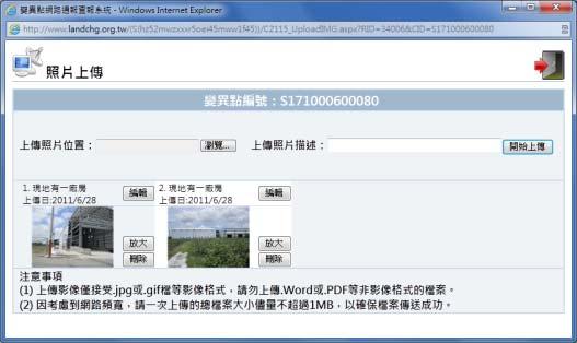
29 Web-based Land Change Reporting System Change Detection System Web-based Reporting System County Township 29
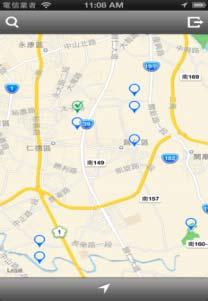
30 Web-based Land Change Reporting System Notices of change spots by Information of Change Spots Investigation Notices 30

31 Web-based Land Change Reporting System Web-base GIS system 31


32 Web-based Land Change Reporting System Download change spot s maps Prior Satellite Digital Map Aerial Photo Subsequent Satellite Google Earth (KML) 32


33 Digital Field Investigation System GPS, digital camera and digital maps Smartphone Apps Aid Field Investigation GPS Digital Camera Smartphone 33

34 Field Investigation Using GPS, Digital Maps Lead the way to the change spot Judge the legality of the use of the land 34
35 Field Investigation Report Through Web-based Land Change Reporting System Report the survey results through internet : text 35


36 Field Investigation Report Report the survey results through internet : picture 36


37 Digital Field Investigation System Smartphone Apps for : Aiding Field Investigation Land Change Reporting 37
38 Digital Field Investigation System Search 國土監測查報 for ios and Android Apple Store Google Play 38

39 Digital Field Investigation System User interface 39

40 Digital Field Investigation System Download Geospatial Data Navigation Information 40


41 Digital Field Investigation Report Through Smartphone Apps Record / Upload Survey Result Coordinates are automatically tagged on photos 41

42 Inspection Progress Report s progress can be inspect through Web-based Land Change Reporting System 42


43 Change Area No. Name of Map H 永安 Prior Data 05/14/2012 Subsequent Data 08/20/2012 Prior Image Field Investigation Report 1/10 Subsequent Image Change Type Description New Building Result Illegal New temple under construction Photo 43


44 Change Area No. Name of Map F 八里 Prior Data 05/25/2012 Subsequent Data 07/02/2012 Prior Image Field Investigation Report 2/10 Subsequent Image Change Type Description New Building Result New build factory Photo Illegal 44


45 Change Area No. Name of Map T 西勢村 Prior Data 06/03/2013 Subsequent Data 07/17/2013 Prior Image Field Investigation Report 3/10 Subsequent Image Change Type Description New Building Result Illegal Illegal farm house Photo 45


46 Change Area No. Name of Map T 載興 Prior Data 05/27/2013 Subsequent Data 07/10/2013 Prior Image Field Investigation Report 4/10 Subsequent Image Change Type Description Water Body Result Illegal fish pond Photo Illegal 46


47 Change Area No. Name of Map U 大和 Prior Data 11/27/2013 Subsequent Data 01/31/2014 Prior Image Field Investigation Report 5/10 Subsequent Image Change Type Description New Road Result New constructed road Photo Illegal 47


48 Change Area No. Name of Map Q 三界埔 Prior Data 02/06/2011 Subsequent Data 04/02/2011 Prior Image Field Investigation Report 6/10 Subsequent Image Change Type Description Grading Result Illegal Industrial waste Photo 48


49 Change Area No. Name of Map N 梧鳳 Prior Data 06/03/2013 Subsequent Data 07/17/2013 Prior Image Field Investigation Report 7/10 Subsequent Image Change Type Description Grading Result Illegal Cement pavement Photo 49


50 Change Area No. Name of Map N 永靖 Prior Data 11/27/2013 Subsequent Data 01/18/2014 Prior Image Field Investigation Report 8/10 Subsequent Image Change Type Description New Building Result Illegal Market and parking lot Photo 50


51 Change Area No. Name of Map F 湊角山 Prior Data 11/09/2013 Subsequent Data 01/30/2014 Prior Image Field Investigation Report 9/10 Subsequent Image Change Type Description Grading Result Illegal Fruit tree in forest land area Photo 51


52 Field Investigation Report 10/10 Change Area No. Name of Map F 橫溪 Prior Data 04/16/2013 Subsequent Data 07/14/2013 Prior Image Subsequent Image Change Type Description New Building Result Illegal Illegal building for recycling use Photo 52
53 Statistics of The average rate of investigation report is over 98% The average ratio of illegal land usage is near 28% 53

54 Volunteer Reporting System Web-based GIS system for volunteer to report suspicious spots (legal? or illegal?) 54


55 Volunteer Reporting System Report suspicious spot by text and photos Description of suspicious spot Locate suspicious spot and feedback coordinates to system Upload photos of suspicious spot 55


56 Volunteer Reporting System Progress report system for suspicious spot investigation 56


57 Volunteer Reporting System 1/4 Change Area No. V9503 Name of Map Prior Data 1/18/2006 Subsequent Data 3/11/2006 Prior Image Subsequent Image Change Type Description Bare Land Result Legal 94 年 12 月 27 日府農保字 C 號函核准之開挖案件 Photo 57


58 Volunteer Reporting System 2/4 Change Area No. V9706 Name of Map Change Type Bare Land Result Illegal Prior Data 2/16/2008 Subsequent Data 5/14/2008 Prior Image Subsequent Image Description 疑似低漥地填土, 人工機具開墾山坡地 Photo 58


59 Volunteer Reporting System 3/4 Change Area No. V9707 Name of Map Prior Data 12/21/2007 Subsequent Data 6/10/2008 Prior Image Subsequent Image Change Type Description Crop Changed Result Illegal 本案變異點之土地占用本轄立霧溪事業區 67 林班地種植蔬菜, 現在靠近台 14 甲線之土地, 為空地, 本案目前已移送民事訴訟繫屬中地 Photo 59


60 Volunteer Reporting System 4/4 Change Area No Name of Map Prior Data 9/09/2008 Subsequent Data 10/26/2008 Prior Image Subsequent Image Change Type Description Bare Land Result Illegal 經 97 年 11 月 26 日農業處水土保持科主辦會勘, 確認現場為山坡地未經許可整地, 已由該處依違反水土保持法規定辦理中 Photo 60

61 Conclusion Dynamic information is important for a successful land management policy 61

62 Thank You For Listening
24GHz BSD Radar. 24 GHz Radar Blind Spot Detection. Installation Guide
 P/N : VS-91A001 Page :1 of 8 24 GHz Radar Blind Spot Detection Installation Guide P/N : VS-91A001 Page :2 of 8 CONTENT 1. SYSTEM ARCHITECTURE TURE 1.1 Layout... 3 1.2 Components.....4 2. Installation 2.1
WG5: AGRICULTURE & FOOD SECURITY FORMOSAT SATELLITES IN AGRICULTURAL MONITORING
 WG5: AGRICULTURE & FOOD SECURITY FORMOSAT SATELLITES IN AGRICULTURAL MONITORING Franz M.C. Cheng & Satellite Image Division National Space Organization, NARLabs www.nspo.org.tw franz.cheng@nspo.narl.org.tw
2018 WITSA Global ICT Excellence Awards Remote Immersive Experience Platform
 2018 WITSA Global ICT Excellence Awards Remote Immersive Experience Platform SECTOR: SUSTAINABLE GROWTH AWARD Remote Immersive Experience Platform, developed by Institute for Information Industry, leverages
User Manual bgn WLAN MODULE MODEL DWM-W042
 User Manual 802.11bgn WLAN MODULE MODEL DWM-W042 The purpose of this manual is to explain correct way how to integrate module DWM-W042 to the end product. It includes procedures that shall assist you to
海象觀測同調性都卜勒微波雷達的開發 林昭暉 國立中央大學水文與海洋科學研究所助理教授 2 國立中央大學水文與海洋科學研究所博士班研究生 2 國立中央大學水文與海洋科學研究所研究助理 國家實驗研究院台灣海洋科技研究中心助理研究員
 第 35 屆海洋工程研討會論文集國立中山大學 2013 年 11 月 Proceedings of the 35 th Ocean Engineering Conference in Taiwan National Sun Yat-sen University, November 2013 海象觀測同調性都卜勒微波雷達的開發 錢樺 1 鄭皓元 2 林昭暉 3 賴堅戊 1 國立中央大學水文與海洋科學研究所助理教授
Using the Keyboard (VGP-WKB11)
") n 32 (VGP-WKB11) A wireless keyboard is supplied with your computer. The wireless keyboard uses a standard key arrangement with additional keys that perform specific functions. Using the Wireless Keyboard
n 32 (VGP-WKB11) A wireless keyboard is supplied with your computer. The wireless keyboard uses a standard key arrangement with additional keys that perform specific functions. Using the Wireless Keyboard
2018 TAIROS 國際論壇 TAIROS International Forum 2018
 2018 TAIROS 國際論壇 TAIROS International Forum 2018 TAIROS 國際論壇邀集美國 MICROSOFT IOT & AI Solutions UL 澳門大學科技學院 國立中央大學電機系 美國約翰霍布金斯大學等多位國際機器人與人工智慧專家齊聚一堂, 深度剖析產業趨勢和技術動態, 預計將吸引國內外產業專業人士參與, 連同 TAIROS 2018 展覽精彩引爆!
OEM Installation Guidance Document For BRCM WLAN + Bluetooth Module, BCM94313HMGB FCC ID: QDS-BRCM1051; IC: 4324A-BRCM1051
 Conditions on using BRCM regulatory approvals: A. Customer must ensure that its product (the CUSTOMER Product ) is electrically identical to Broadcom s reference designs. Customer acknowledges that any
How to Find the Best Expert Witness & Techniques for Preparing For Expert Witness Depositions
 全國工業總會研討會 : 美國聯邦法院訴訟之進階策略 CNFI Seminars: Advanced U.S. Federal Court Litigation Strategies 全國工業總會 Chinese National Federation of Industries (CNFI) 博欽律師事務所 Perkins Coie LLP 博欽外國法事務律師事務所 Perkins Coie Foreign
BIOGRAPHICAL DETAILS OF DIRECTORS, COMPANY SECRETARY AND CHIEF FINANCIAL OFFICER
 BIOGRAPHICAL DETAILS OF DIRECTORS, EXECUTIVE DIRECTORS Mr. Lin Fan, aged 50, is the chairman and an executive director of the Company. Mr. Lin was appointed as the vice president of CIHC and CIHK in July
DBUB-P705 Bluetooth Adapter User s Manual
 DBUB-P705 Bluetooth Adapter User s Manual This document provides safety instructions and describes the specifications. Read this document carefully before installing to ensure your safety and product performance.
歷年具審稿之學術論文 (Refereed Papers)(* Corresponding author)
(* Corresponding author)") 歷年具審稿之學術論文 (Refereed Papers)(* Corresponding author) 1. 呂世通 *(2000), 公共工程變更設計原因之統計分析 - 以台北市公共工程為例, 審計季刊, 第二十一卷, 第一期, pp. 49-66 2. 謝定亞 呂世通 * 陳正鈞 (2001), 台北市公共工程完工驗收延遲原因分析及其改善途徑, 審計季刊, 第二十二卷, 第一期, pp.27-43
歷年具審稿之學術論文 (Refereed Papers)(* Corresponding author) 1. 呂世通 *(2000), 公共工程變更設計原因之統計分析 - 以台北市公共工程為例, 審計季刊, 第二十一卷, 第一期, pp. 49-66 2. 謝定亞 呂世通 * 陳正鈞 (2001), 台北市公共工程完工驗收延遲原因分析及其改善途徑, 審計季刊, 第二十二卷, 第一期, pp.27-43
Wireless Communications
 Wireless Communications Chapter 2 Modern Wireless Communication Systems [1] The widespread adoption of wireless communications was accelerated in the mid 1990s, when governments throughout the world provided
Bluetooth Module : MB8811C1 SPECIFICATION. Tx Power Rx Sensitivity < -70dBm (BER 0.1%)
") Bluetooth Module : MB8811C1 [top] [bottom] This MB8811C1 Module is compatible with Bluetooth specification version 4.0. MB8811C1 is a fully integrated RF, baseband controller etc. SPECIFICATION Main Chips
Bluetooth Module : MB8811C1 [top] [bottom] This MB8811C1 Module is compatible with Bluetooth specification version 4.0. MB8811C1 is a fully integrated RF, baseband controller etc. SPECIFICATION Main Chips
Taipei: Places & Spaces for History & Memory
 Taipei: Places & Spaces for History & Memory 超級大國民 Super Citizen Ko Outline Discussion Questions Place and Space Super Citizen Ko: General Intro Places: &, Home & Political Sites Spaces of Memories, Quest
WML- 43 User Manual. Content. 1. General. Page 1 of 6 WML-C43_User_Manual Jun
 Page 1 of 6 WML- 43 User Manual The purpose of this manual is to explain correct way how to integrate module WML- 43 to the end product. It includes procedures that shall assist you to avoid unforeseen
Multimeter 3 1/2經濟款數位電錶 MT User s Manual 2nd Edition, Copyright by Prokit s Industries Co., Ltd.
 MT-1210 Multimeter 3 1/2經濟款數位電錶 User s Manual 2nd Edition, 2017 2017 Copyright by Prokit s Industries Co., Ltd. SAFETY INFORMATION This multimeter has been designed according to IEC 1010 concerning electronic
GENERAL RULES & REGULATIONS FOR THE 23 rd DA DUN FINE ARTS EXHIBITION OF TAICHUNG CITY
 GENERAL RULES & REGULATIONS FOR THE 23 rd DA DUN FINE ARTS EXHIBITION OF TAICHUNG CITY 1. Purpose: To enhance international cultural exchanges and raise standards for artistic creation. 2. Organizers:
Taipei: Places & Spaces for History & Memory
 Taipei: Places & Spaces for History & Memory 超級大國民 Super Citizen Ko Question No: 7 Types: 1 theory, 6 text 6. Places or Spatial P 5. Techniqu e 1. Theme 4. Irony 3. Plot -- ending 2. Main Character experience
Academic Year
 Academic Year 2018-19 2018 Autumn Term: Chinese Language Computing/Electronic & Computer Engineering GEN B167CF Investment Fundamentals 基礎投資知識 GEN A205CF Discovering Cultures in China 中國文化探索 GEN E142CF
MULTILAYER HIGH CURRENT/HIGH FREQUENCY FERRITE CHIP BEAD
 INTRODUCTION 產品介紹 Multilayer high current chip beads are SMD components that possess a low DC resistance. Their impedance mainly comprises resistive part. Therefore, when this component is inserted in
Radio Frequency Data For Class B
 For 4409209 September 2013, Rev.2, 8/17 2013-2017 Fluke Corporation. All rights reserved. All product names are trademarks of their respective companies. Introduction Information about radio frequency
行政院國家科學委員會專題研究計畫成果報告
 行政院國家科學委員會專題研究計畫成果報告 W-CDMA 基地台接收系統之初始擷取與多用戶偵測子系統之研究與實作 Study and Implementation of the Acquisition and Multiuser Detection Subsystem for W-CDMA systems 計畫編號 :NSC 90-229-E-009-0 執行期限 : 90 年 月 日至 9 年 7
Model RM Wireless Link Module External Interface Specification
 Model 420128RM Wireless Link Module External Interface Specification 2016/6/13 Introduction Model 420128RM Wireless Link Module is for the low latency wireless link between console and bass box or rear
HONG KONG SAR, CHINA
 HONG KONG SAR, CHINA Richard Kirke MANAGING DIRECTOR HONG KONG Richard.Kirke@colliers.com DIR +852 2822 0699 FAX +852 2107 6001 Richard Kirke joined in 2009 as Managing Director of the Hong Kong office.
Brazil. Canada. European Union (EU) Japan. PRSE User Manual - Certifications
 Japan. PRSE User Manual - Certifications") Country/Region Brazil Certification Information Canada Este equipamento opera em caráter secundário, isto é, não tem direito a proteção contra interferência prejudicial, mesmo de estações do mesmo tipo,
Country/Region Brazil Certification Information Canada Este equipamento opera em caráter secundário, isto é, não tem direito a proteção contra interferência prejudicial, mesmo de estações do mesmo tipo,
bizhub C450/C352/C351 Shortcut Manual
 bizhub C450/C352/C351 Shortcut Manual For detail information,please refer to the User Manual C450/C352/C351 Shortcut Manual Place Originals on the Feeder(Face Up) or/ On the Original Glass (Face Down)
工業 4.0. Development of new products Creativity and Innovation methods for small and medium sized enterprises. May I introduce myself..
 Smart Home Smart Factory Embedded Systems Smart City Guten Tag! Prof. Dr. Ing. Henrik Schnegas Dept. of Mechanical Engineering / Engineering Design Hanseatic Town of Wismar, Germany Cyber physical systems
User guide Air USB. For other languages visit:
 User guide Air USB For other languages visit: /support Air USB 2 Congratulations on your new Profoto product! Air USB Regardless if you chose a new flash or a new light-shaping tool, know that almost half
香港工商專業訪京團 全國政協副主席董建華率領 70 多名工商及專業界人士, 於 9 月 22 日訪京, 並獲國家主席習近平接見, 香港測量師學會上任會長賴旭輝測量師, 代表學會參與了訪京團
 香港工商專業訪京團 全國政協副主席董建華率領 70 多名工商及專業界人士, 於 9 月 22 日訪京, 並獲國家主席習近平接見, 香港測量師學會上任會長賴旭輝測量師, 代表學會參與了訪京團 訪京團由全國政協副主席 前特首董建華擔任團長, 國務院港澳辦主任王光亞, 和中聯辦主任張曉明擔任顧問 ; 人大委員長張德江 國家副主席李源潮亦有出席會面, 晚上並由張德江委員長宴請 於會面期間, 習近平主席充份肯定包括香港工商界
Monitoring Natural Disasters with Small Satellites Smart Satellite Based Geospatial System for Environmental Protection
 Monitoring Natural Disasters with Small Satellites Smart Satellite Based Geospatial System for Environmental Protection Krištof Oštir, Space-SI, Slovenia Contents Natural and technological disasters Current
樊晉源簡歷 元智大學 / 工業工程與管理研究所 / 博士 (2005/06/30~2009/06/30) 大葉大學 / 事業經營研究所 / 碩士 (2001/06/30~2003/06/30) 科技政策研究與資訊中心政策研究組副研究員 (2014/01/01~ 迄今 )
 大葉大學 / 事業經營研究所 / 碩士 (2001/06/30~2003/06/30) 科技政策研究與資訊中心政策研究組副研究員 (2014/01/01~ 迄今 )") 樊晉源簡歷 一 基本資料 : 姓名 : 樊晉源 E-MAIL:cyfan@stpi.narl.org.tw 二 教育背景 : 元智大學 / 工業工程與管理研究所 / 博士 (2005/06/30~2009/06/30) 大葉大學 / 事業經營研究所 / 碩士 (2001/06/30~2003/06/30) 三 現職 : 科技政策研究與資訊中心政策研究組副研究員 (2014/01/01 迄今 ) 四
樊晉源簡歷 一 基本資料 : 姓名 : 樊晉源 E-MAIL:cyfan@stpi.narl.org.tw 二 教育背景 : 元智大學 / 工業工程與管理研究所 / 博士 (2005/06/30~2009/06/30) 大葉大學 / 事業經營研究所 / 碩士 (2001/06/30~2003/06/30) 三 現職 : 科技政策研究與資訊中心政策研究組副研究員 (2014/01/01 迄今 ) 四
聽力內容與圖片不符, 因此選 (B) 例題 Amy: Who s that man? Mike: 答案是 (C) (A) He s a cook. (B) Yes, he s my classmate. (C) He s our coach.
 例題 Amy: Who s that man? Mike: 答案是 (C) (A) He s a cook. (B) Yes, he s my classmate. (C) He s our coach.") 新北市立江翠國民中學 103 學年度第一學期第一次定期考查七年級英語科試卷 P.1 測驗說明 : ( 一 ) 範圍 : 翰林版第一冊 Starter Unit 至 Review 1 ( 二 ) 本試卷含答案卷共 4 頁 ( 雙面印製 ) ( 三 ) 全部試題共 50 題, 第 1-35 題為單一選擇題, 請以 2B 鉛筆將正確答案的代碼劃在答案卡上, 第 36-50 題請用黑色或藍色原子筆寫在第 4
新北市立江翠國民中學 103 學年度第一學期第一次定期考查七年級英語科試卷 P.1 測驗說明 : ( 一 ) 範圍 : 翰林版第一冊 Starter Unit 至 Review 1 ( 二 ) 本試卷含答案卷共 4 頁 ( 雙面印製 ) ( 三 ) 全部試題共 50 題, 第 1-35 題為單一選擇題, 請以 2B 鉛筆將正確答案的代碼劃在答案卡上, 第 36-50 題請用黑色或藍色原子筆寫在第 4
國立交通大學 電子研究所 碩士論文 多電荷幫浦系統及可切換級數負電壓產生器之設計及生醫晶片應用
 國立交通大學 電子研究所 碩士論文 多電荷幫浦系統及可切換級數負電壓產生器之設計及生醫晶片應用 Design of Multiple-Charge-Pump System and Stage-Selective Negative Voltage Generator for Biomedical Applications 研究生 : 林曉平 (Shiau-Pin Lin) 指導教授 : 柯明道教授 (Prof.
電機驅動方案產品介紹 廣閎科技 2016 May. 25 inergy 大比特研讨会资料区 :
 電機驅動方案產品介紹 廣閎科技 2016 May. 25 Copyright 2016 technology incorporation. All rights reserved. 廣閎科技簡介 廣閎科技是專注於節能方案應用之 IC 設計公司, 提供了由方案角度延伸的各類 IC 產品, 包含了照明 電源及電機驅動領域 廣閎科技不僅提供高品質的 IC 產品, 也協助客戶完成系統的設計及生產, 近幾年來更結合了許多上下游產業提供客戶更完整的服務
機械工程研究所博士聯絡電話 : (03) International Crisis Management Association. 2003,2005 Training Organization 2003, 2005, 2007,2009.
 International Crisis Management Association. 2003,2005 Training Organization 2003, 2005, 2007,2009.") 姓名 : 陳文欽學歷 : 美國佛羅里達大學 (University of Florida) 機械工程研究所博士聯絡電話 : (03) 518-6585 傳真 : (03) 518-6575 E - mail:wenchin@chu.edu.tw 類別 : 專任師資職稱 : 教授兼推廣教育處處長研究專長 : 製程參數最佳化系統 先進製程控制與類神經應用 自動化監控系統 績效評估 國內外之成就與榮譽 International
姓名 : 陳文欽學歷 : 美國佛羅里達大學 (University of Florida) 機械工程研究所博士聯絡電話 : (03) 518-6585 傳真 : (03) 518-6575 E - mail:wenchin@chu.edu.tw 類別 : 專任師資職稱 : 教授兼推廣教育處處長研究專長 : 製程參數最佳化系統 先進製程控制與類神經應用 自動化監控系統 績效評估 國內外之成就與榮譽 International
User s Manual. Wi-Fi Smart Plug HS100 Wi-Fi Smart Plug with Energy Monitoring HS REV 2.0.0
 Wi-Fi Smart Plug HS100 Wi-Fi Smart Plug with Energy Monitoring HS110 1910012024 REV 2.0.0 Copyright & Trademarks Specifications are subject to change without notice. TP-Link is a registered trademark of
Package Contents. If any of the above items are missing, please contact your reseller. System Requirements
 Package Contents DWL-8600AP 802.11ac Power over Ethernet (PoE) Access Point Ethernet Cable Console Cable Mounting Plate CD-ROM Note: No PSU supplied. To power the units use an D-Link PoE switch or the
8000 Postcard Images of the Korean Colonial Period Digitization Process
 8000 Postcard Images of the Korean Colonial Period Digitization Process Jee-Young Park Korean Studies Librarian The University of Chicago Library 2017 CEAL CKM About the Postcard Image Collection of Colonial
to possess 2. Description of type or types of irradiating apparatus for which licence is required : dental X-ray machine
 RADIATION ORDINANCE (Chapter 303) APPLICATION FOR IRRADIATING APPARATUS LICENCE I ABC Company Limited (Name of full) of Information (Address in full) hereby make application for a licence (a) to possess
NON-PHOTOGRAPHIC SYSTEMS: Multispectral Scanners Medium and coarse resolution sensor comparisons: Landsat, SPOT, AVHRR and MODIS
 NON-PHOTOGRAPHIC SYSTEMS: Multispectral Scanners Medium and coarse resolution sensor comparisons: Landsat, SPOT, AVHRR and MODIS CLASSIFICATION OF NONPHOTOGRAPHIC REMOTE SENSORS PASSIVE ACTIVE DIGITAL
1995 年間, 彼擔任香港期貨交易所主席,1989 至 2000 年同時為香港期貨交易所及香港期貨結算有限公司董事 彼曾任香港證券及期貨事務監察委員會諮詢委員會成員, 及股東權益小組成員 梁肩負培育金融專才的使命 彼曾任香港
 LEONG Ka-Chai 梁家齊 OBE SBS JP 銀紫荊星章太平紳士 Leong Ka-Chai has over 30 years experience in the securities and derivatives industry. He has been the Chairman of Roctec group of companies since 1983. He is committed
igs01 Specification BLE( Bluetooth Smart) to WiFi Gateway Features Applications Block Diagram Specification Ver.1b
 to WiFi Gateway Features Applications Block Diagram Specification Ver.1b") Specification Ver.1b igs01 Specification BLE( Bluetooth Smart) to WiFi Gateway igs01 is a BLE to WiFi gateway and bridge. The gateway reads ibeacon and Eddystone like beacon or customized Tag( w/ sensor)
Specification Ver.1b igs01 Specification BLE( Bluetooth Smart) to WiFi Gateway igs01 is a BLE to WiFi gateway and bridge. The gateway reads ibeacon and Eddystone like beacon or customized Tag( w/ sensor)
DISTINGUISHING URBAN BUILT-UP AND BARE SOIL FEATURES FROM LANDSAT 8 OLI IMAGERY USING DIFFERENT DEVELOPED BAND INDICES
 DISTINGUISHING URBAN BUILT-UP AND BARE SOIL FEATURES FROM LANDSAT 8 OLI IMAGERY USING DIFFERENT DEVELOPED BAND INDICES Mark Daryl C. Janiola (1), Jigg L. Pelayo (1), John Louis J. Gacad (1) (1) Central
Quick Installation Guide
 Quick Installation Guide This document will guide you through the basic installation process for your new D-Link Access Point. DWL-8710AP Documentation is also available on the CD and the D-Link website
R-GAGE Q240RA-IL (-UL) Sensor
 Sensor") R-GAGE QRA-IL (-UL) Sensor Datasheet Radar-Based Dual-Zone Narrow-Beam Sensors for Detection of Moving and Stationary Targets FMCW (true-presence) radar detects moving and stationary objects Narrow beam
R-GAGE QRA-IL (-UL) Sensor Datasheet Radar-Based Dual-Zone Narrow-Beam Sensors for Detection of Moving and Stationary Targets FMCW (true-presence) radar detects moving and stationary objects Narrow beam
PART III: BOOTH CONSTRUCTION FORMS 第三部分..攤位裝修表格
 PART III: BOOTH CONSTRUCTION FORMS 第三部分..攤位裝修表格 FORM 表格 DESCRIPTION 表格名稱 SUBMISSION 表格遞交 DEADLINE 遞交期限 RETURN TO 交回 2.1 Raw Space Exhibitors Declaration 展覽空地參展商申報 Compulsory for Raw Space Exhibitors 空地參展商必須交回
Belt and Road Initiative: Infrastructure Financing 一帶一路基建融資論壇暨對話
 Joint Organisers 聯 合 主 辦 機 構 : Joint Organisers: Forum-cum-Dialogue on HKIBHKIB CPD CPD CPD The TheLaw Law Society Society CPD 3.5 hours 2.5 2.5points points AM AM 3.5 hours PM 3 hours 2.5 points PM 3
Remote Sensing Platforms
 Remote Sensing Platforms Remote Sensing Platforms - Introduction Allow observer and/or sensor to be above the target/phenomena of interest Two primary categories Aircraft Spacecraft Each type offers different
Unit 6: Movies. Film Genre ( 可加 film 或 movie) Adjectives. Vocabulary. animation. action. drama. comedy. crime. romance. horror
 Adjectives. Vocabulary. animation. action. drama. comedy. crime. romance. horror") Unit 6: Movies Vocabulary Film Genre ( 可加 film 或 movie) action comedy romance horror thriller adventure animation drama crime science fiction (sci-fi) musical war Adjectives exciting fascinating terrifying
Unit 6: Movies Vocabulary Film Genre ( 可加 film 或 movie) action comedy romance horror thriller adventure animation drama crime science fiction (sci-fi) musical war Adjectives exciting fascinating terrifying
Abstract Quickbird Vs Aerial photos in identifying man-made objects
 Abstract Quickbird Vs Aerial s in identifying man-made objects Abdullah Mah abdullah.mah@aramco.com Remote Sensing Group, emap Division Integrated Solutions Services Department (ISSD) Saudi Aramco, Dhahran
微奈米光電製程 管傑雄 國立台灣大學電機系
 微奈米光電製程 管傑雄 國立台灣大學電機系 1 Outlines 1. 基本概念 2. Optical Lithography 3. E-Beam Lithography 4. Etching Techniques 5. Applications 6. Summary 2 基本概念 (I) Scattering Length 載子傳導並遭遇散射 1. 影響散射機制 : 雜質 ( 低溫 ) 及聲子振動
計畫編號 : NSC E 執行時程 : 93 年 8 月 1 日至 94 年 7 月 31 日 計畫主持人 : 連豊力 國立台灣大學電機系助理教授 共同主持人 : 呂良鴻 國立台灣大學電子所助理教授 計畫參與人員 : 許瑋豪 方文杰 林雍倫 馮天俊 魏嘉樑 麥肇元
 微型仿生生物體之研發 (2/3) 子計畫二 : 生物群體協調行為之探討與無線通訊機制之整合 (2/3) Study of Group Behaviors of Biological Systems and Integration of Wireless Communication Protocol Design 計畫編號 : NSC 93-2213-E-002-049- 執行時程 : 93 年 8
EAST ASIA THIRD-SECTOR RESEARCHERS NETWORK NEWSLETTER NEWS 最新消息
 EAST ASIA THIRD-SECTOR RESEARCHERS NETWORK NEWSLETTER 東亞第三部門研究人員網絡通信 Issue 5 / February, 2018 CONTENTS 目錄 News 最新消息 Introduction 簡介 Publications 學術出版 VOLUNTAS. Volume 28, Issue 6, December 2017. Conference
測試報告 TestReport 號碼 (No.) : CE/2017/B1020 日期 (Date) : 2017/11/13 明輝化工實業有限公司 MIN FEI CHEMICALS INDUSTRIES CO., LTD. 新北市土城區大安路 138 巷 32 號 NO. 32, LANE 13
 : CE/2017/B1020 日期 (Date) : 2017/11/13 明輝化工實業有限公司 MIN FEI CHEMICALS INDUSTRIES CO., LTD. 新北市土城區大安路 138 巷 32 號 NO. 32, LANE 13") 頁數 (Page) 1 of 5 以下測試樣品係由申請廠商所提供及確認 (The following sample(s) was/were submitted and identified by/on behalf of the applicant as) 送樣廠商 (Sample Submitted By) 樣品名稱 (Sample Description) 樣品型號 (Style/Item No.)
頁數 (Page) 1 of 5 以下測試樣品係由申請廠商所提供及確認 (The following sample(s) was/were submitted and identified by/on behalf of the applicant as) 送樣廠商 (Sample Submitted By) 樣品名稱 (Sample Description) 樣品型號 (Style/Item No.)
Dr RV Ahilan 20 th March 2018
 Dr RV Ahilan 20 th March 2018 ONE PARTNER. WORLDWIDE SUPPORT 一个合作伙伴 国际资源支持 Renewables 新能源 Shipping 航运 Established 1979 成立 LOC Group Marine and Engineering Consultants Oil & Gas 能源 400+ staff 员工 30 offices
BOARD OF DIRECTORS AND COMMITTEES 董事局及委員會
 BOARD OF DIRECTORS AND COMMITTEES 04 Hong Kong Internet Registration Corporation Limited 2017 Annual Report Hong Kong Internet Registration Corporation Limited ( HKIRC ) is a non-profit-distributing, non-statutory,
允許學生個人 非營利性的圖書館或公立學校合理使用本基金會網站所提供之各項試題及其解答 可直接下載而不須申請. 重版 系統地複製或大量重製這些資料的任何部分, 必須獲得財團法人臺北市九章數學教育基金會的授權許可 申請此項授權請電郵
 注意 : 允許學生個人 非營利性的圖書館或公立學校合理使用本基金會網站所提供之各項試題及其解答 可直接下載而不須申請 重版 系統地複製或大量重製這些資料的任何部分, 必須獲得財團法人臺北市九章數學教育基金會的授權許可 申請此項授權請電郵 ccmp@seed.net.tw Notice: Individual students, nonprofit libraries, or schools are
5G Technology Development in ITRI
 5G Technology Development in ITRI Pang-An Ting Division for Emerging Wireless Application Technology ICL/ITRI 2017/01/22 Copyright 2017 ITRI 工業技術研究院 Our Views on 5G R&D Copyright 2017 ITRI 工業技術研究院 3 Our
RTL8188CE b/g/n RTL8188CE minicard User s Manual. Rev Dec Realtek Semiconductor Corp.
 802.11b/g/n RTL8188CE minicard Rev. 1.0 03 Dec 2009 Realtek Semiconductor Corp. No. 2, Innovation Road II, Hsinchu Science Park, Hsinchu 300, Taiwan Tel.: +886-3-578-0211. Fax: +886-3-577-6047 www.realtek.com.tw
中华人民共和国国家计量技术规范 定量包装商品净含量计量检验规则
 National Metrology Technical Specifications of the People's Republic of China 中华人民共和国国家计量技术规范 JJF 1070-2005 Rules of Metrological Testing for Net Quantity of Products in Prepackages with Fixed Content
bizhub 751 / 601 Shortcut Manual
 bizhub 751 / 601 Shortcut Manual For detail information,please refer to the User Manual 1 1. Touch Panel 2. Main Power 3. Power 4. Mode Memory 5. Utility/Counter 6. Reset 7. Interrupt 8. Stop 9. Proof
ORDER FORM 3A - Booth Packages Rental 訂購表格 3A - 攤位裝修設計租用
 ORDER FORM 3A - Booth Packages Rental 訂購表格 3A - 攤位裝修設計租用 Post or fax to 請郵寄或傳真往 : Tel 電話 : (852) 3605 9551/ 3605 9615 Fax 傳真 : (852) 3605 9480 Optional 隨意交回 DEADLINE : January 8, 2016 截止日期 :2016 年 1 月
Selected Resources for the Study & Research on Local Gazetteers
 Selected Resources for the Study & Research on Local Gazetteers Compiled by Tang Li, East Asia Library, Yale University. tang.li@yale.edu Union catalogue 1. 中國地方志聯合目錄 The standard union catalogue of Chinese
Global Positioning System (GPS)
") Global Positioning System (GPS) GPS enables users to easily record the location of natural and man-made features on the land. It allows users to identify where a photo or video is taken, revisit previously
Global Positioning System (GPS) GPS enables users to easily record the location of natural and man-made features on the land. It allows users to identify where a photo or video is taken, revisit previously
ROLE OF SATELLITE DATA APPLICATION IN CADASTRAL MAP AND DIGITIZATION OF LAND RECORDS DR.T. RAVISANKAR GROUP HEAD (LRUMG) RSAA/NRSC/ISRO /DOS HYDERABAD
 RSAA/NRSC/ISRO /DOS HYDERABAD") ROLE OF SATELLITE DATA APPLICATION IN CADASTRAL MAP AND DIGITIZATION OF LAND RECORDS DR.T. RAVISANKAR GROUP HEAD (LRUMG) RSAA/NRSC/ISRO /DOS HYDERABAD WORKSHOP on Best Practices under National Land Records
ROLE OF SATELLITE DATA APPLICATION IN CADASTRAL MAP AND DIGITIZATION OF LAND RECORDS DR.T. RAVISANKAR GROUP HEAD (LRUMG) RSAA/NRSC/ISRO /DOS HYDERABAD WORKSHOP on Best Practices under National Land Records
User guide Air Remote TTL-S
 User guide Air Remote TTL-S For other languages visit: /support Air Remote TTL-S 2 Congratulations on your new Profoto product! Regardless if you chose a new flash or a new light shaping tool, know that
2013 Vol. 6. Focus Topic : China A View From the Future
 2013 Vol. 6 Focus Topic : China A View From the Future Profile: The Chinese University of Hong Kong The Chinese University of Hong Kong (CUHK) was established in 1963 after the amalgamation of existing
Alien invasion: Is There Really Such a Thing?
 Unit 23 Alien invasion: Is There Really Such a Thing? Grace Hsu Pre-reading 1. Use your imagination to draw an alien. 2. How much do you know about Superman (Clark Kent) and his birth planet Krypton? 3.
BM70 Regulatory Compliance Information
 Revision 0.1 Dec 2015 This document covers the Regulatory Compliance information which is part of the BM70 Module datasheet and related documents shared with customers. 1.0 ANTENNA 1.1 Antenna Characteristics
CANNONWAY CONSTRUCTION CONSULTANTS (MACAU ) CO. LTD. Cannonway 建築諮詢顧問 ( 澳門 ) 有限公司
 CO. LTD. Cannonway 建築諮詢顧問 ( 澳門 ) 有限公司") Presents A HALF DAY SEMINAR The Effect of the Economic Tsunami on Construction and Investment in Macau 主辨金融海嘯下如何影響澳門的建設界與投資 **Revised Date To be held on 11 th December 2008 Revised Date** From 2:00 to
Presents A HALF DAY SEMINAR The Effect of the Economic Tsunami on Construction and Investment in Macau 主辨金融海嘯下如何影響澳門的建設界與投資 **Revised Date To be held on 11 th December 2008 Revised Date** From 2:00 to
Leading Provider of Industrial Networking Solutions
 Leading Provider of Industrial Networking Solutions Moxa at a Glance Moxa was founded in 1987, and is now a leading supplier of device networking products and solutions for industry. Moxa has networked
Satellite and GPS technology
 Satellite and GPS technology Maryna Strydom (GIS Tg SA) Tel: (011) 441 6163 mstrydom@srk.co.za Overview General How Earth Observation Satellites work Uses of different EOS outputs How GPS work Types of
Proposed Programme 草擬程序表. Welcoming Remarks by Hong Kong Trade Development Council 由香港貿易發展局致歡迎辭
 Symposium on Innovation & Technology 創新科技論壇 Date 日期 : 13 / 10 / 2017 (Friday 星期五 ) Time 時間 : 10:15am 4:35pm Venue 地點 : Theatre I, Hong Kong Convention & Exhibition Centre 香港會議展覽中心演講廳一 Language 語言 : English
Remote Sensing. in Agriculture. Dr. Baqer Ramadhan CRP 514 Geographic Information System. Adel M. Al-Rebh G Term Paper.
 Remote Sensing in Agriculture Term Paper to Dr. Baqer Ramadhan CRP 514 Geographic Information System By Adel M. Al-Rebh G199325390 May 2012 Table of Contents 1.0 Introduction... 4 2.0 Objective... 4 3.0
Milton Group Newsletter Season 1, 2015
 1 Milton Group Project Management Workshop 2015 2 We are Celebrating 25th Anniversary 2015 3 Milton Granted The 4th outstanding SME Social Responsibility Award 2015 by The Mirror Post 4 Milton builds a
National Standard of the People's Republic of China 中华人民共和国国家标准
 UDC GB National Standard of the People's Republic of China 中华人民共和国国家标准 P GB/T 50062 2008 Code for Design of Relaying Protection and Automatic Device of Electric Power Installations 电力装置的继电保护和自动装置设计规范 Issued
GEOGRAPHIC INFORMATION SYSTEMS Lecture 22: Field Mapping with GPS
 GEOGRAPHIC INFORMATION SYSTEMS Lecture 22: Field Mapping with GPS GPS Receivers - there are many GPS receivers on the market today - some receivers are relatively inexpensive (recreational grade receivers)
BA 商品多樣化 商品多樣性的介紹 可以和感應器和指示燈等各種元件連接的端子台模組 有 點型 ( 輸入 ) 點型 ( 輸入 輸出 ) 0 點型 ( 輸入 輸出 ) 等種類 可以不經由繼電器轉接而可以和空氣閥和電磁閥等直接連接的 00mA 開關型式 配備可簡單進行動作確認的 LED 指示燈 DIN 軌
 點型 ( 輸入 輸出 ) 0 點型 ( 輸入 輸出 ) 等種類 可以不經由繼電器轉接而可以和空氣閥和電磁閥等直接連接的 00mA 開關型式 配備可簡單進行動作確認的 LED 指示燈 DIN 軌") e.enproteko.com BA 型連接端子系列 用一對纜線傳送多數個信號的省配線 模組備有多樣化系列產品 依各類需求 可自由自在做應用組合 益 成 h 自 H ttp ://s 動控 ale 制.en 材 pro 料 tek 行 o.c om 特 長 一對纜線連接 輸入 / 輸出機器最遠可達 00m B A 型 連 接 端 子 系 列 Q 使用前 配線作業及維修之效率化 防止配線錯誤 削減成本
e.enproteko.com BA 型連接端子系列 用一對纜線傳送多數個信號的省配線 模組備有多樣化系列產品 依各類需求 可自由自在做應用組合 益 成 h 自 H ttp ://s 動控 ale 制.en 材 pro 料 tek 行 o.c om 特 長 一對纜線連接 輸入 / 輸出機器最遠可達 00m B A 型 連 接 端 子 系 列 Q 使用前 配線作業及維修之效率化 防止配線錯誤 削減成本
DIGITALGLOBE SATELLITE IMAGERY AND CLOUD SERVICES FOR SUGARCANE MAPPING
 DIGITALGLOBE SATELLITE IMAGERY AND CLOUD SERVICES FOR SUGARCANE MAPPING PRESENTER: DILLON PANIZZOLO (TECHNICAL MANAGER) COMPANY: GEO DATA DESIGN DATE: 18 TH AUGUST 2015 SASTA Congress Sugar Cane Mapping
The studies began when the Tiros satellites (1960) provided man s first synoptic view of the Earth s weather systems.
 provided man s first synoptic view of the Earth s weather systems.") Remote sensing of the Earth from orbital altitudes was recognized in the mid-1960 s as a potential technique for obtaining information important for the effective use and conservation of natural resources.
Remote sensing of the Earth from orbital altitudes was recognized in the mid-1960 s as a potential technique for obtaining information important for the effective use and conservation of natural resources.
ジェスチャ併用型 Voice-to-MIDI システムの提案 第五回知識創造支援システムシンポジウム報告書 : 本著作物の著作権は著者に帰属します
 JAIST Reposi https://dspace.j Title ジェスチャ併用型 Voice-to-MIDI システムの提案 Author(s) 伊藤, 直樹 ; 西本, 一志 Citation 第五回知識創造支援システムシンポジウム報告書 : 167-172 Issue Date 2008-03-14 Type Conference Paper Text version author URL
允許學生個人 非營利性的圖書館或公立學校合理使用本基金會網站所提供之各項試題及其解答 可直接下載而不須申請. 重版 系統地複製或大量重製這些資料的任何部分, 必須獲得財團法人臺北市九章數學教育基金會的授權許可 申請此項授權請電郵
 注意 : 允許學生個人 非營利性的圖書館或公立學校合理使用本基金會網站所提供之各項試題及其解答 可直接下載而不須申請 重版 系統地複製或大量重製這些資料的任何部分, 必須獲得財團法人臺北市九章數學教育基金會的授權許可 申請此項授權請電郵 ccmp@seed.net.tw Notice: Individual students, nonprofit libraries, or schools are
第壹部分 : 選擇題 (60 分 ) 一 綜合測驗 ( 第 1-15 題, 每題 2 分, 共 30 分 )
 一 綜合測驗 ( 第 1-15 題, 每題 2 分, 共 30 分 )") 第壹部分 : 選擇題 (60 分 ) 一 綜合測驗 ( 第 1-15 題, 每題 2 分, 共 30 分 ) 說明 : 下列三篇短文共有 15 個空格, 請依短文文意, 選出一個最適合該空格的答案, 並將代號標示在答案卡上 1-5 題為題組 There is majesty about the sea, which covers over 70 percent of the Earth s surface.
第壹部分 : 選擇題 (60 分 ) 一 綜合測驗 ( 第 1-15 題, 每題 2 分, 共 30 分 ) 說明 : 下列三篇短文共有 15 個空格, 請依短文文意, 選出一個最適合該空格的答案, 並將代號標示在答案卡上 1-5 題為題組 There is majesty about the sea, which covers over 70 percent of the Earth s surface.
Introduction of Satellite Remote Sensing
 Introduction of Satellite Remote Sensing Spatial Resolution (Pixel size) Spectral Resolution (Bands) Resolutions of Remote Sensing 1. Spatial (what area and how detailed) 2. Spectral (what colors bands)
DIRECTORS, MANAGEMENT AND STAFF
 DIRECTORS Executive Directors Mr. Zhu Yu Guo ( 朱玉國 ), aged 52, was one of the two founders of our Group. Mr. Zhu is the husband of Mrs. Zhu, our non-executive Director, and the father of Mr. Zhu Mo Qun,
The studies began when the Tiros satellites (1960) provided man s first synoptic view of the Earth s weather systems.
 provided man s first synoptic view of the Earth s weather systems.") Remote sensing of the Earth from orbital altitudes was recognized in the mid-1960 s as a potential technique for obtaining information important for the effective use and conservation of natural resources.
Remote sensing of the Earth from orbital altitudes was recognized in the mid-1960 s as a potential technique for obtaining information important for the effective use and conservation of natural resources.
The audience has given us a lot of positive feedback, some typical ones are listed below:
 NEWSLETTER December 2010 Successful Closing of 2 nd Sharing Best Practice Workshop The 2 nd Sharing Best Practice Workshop held on 2 nd and 3 rd of December, 2010 at the Nansha Grand Hotel cohosted by
User Guide. AC1300 Whole Home Wi-Fi System Deco M5 Router
 User Guide AC1300 Whole Home Wi-Fi System Deco M5 Router REV1.0.0 1910012013 Contents About This Guide..................................................... 1 Chapter 1. Get to Know Your Deco...................................
Quick Reference Guide
 Sony Remote Control RMF-TX300E, RMF-TX300U, RMF-TX300B, RMF-TX301E, RMF-TX300A, RMF-TX300P, RMF-TX300T, RMF-TX300C, RMF-TX300J Quick Reference Guide CONTROLLING YOUR TV (English) 1. Press Power key to
Remote Sensing Platforms
 Types of Platforms Lighter-than-air Remote Sensing Platforms Free floating balloons Restricted by atmospheric conditions Used to acquire meteorological/atmospheric data Blimps/dirigibles Major role - news
國立交通大學 經營管理研究所 碩士論文 上游獨占下之外部授權者的最適授權策略. The Optimal Licensing Strategy of an Outsider Patentee under. the Single Upstream Supplier 研究生 : 林錦宏
 國立交通大學 經營管理研究所 碩士論文 上游獨占下之外部授權者的最適授權策略 The Optimal Licensing Strategy of an Outsider Patentee under the Single Upstream Supplier 研究生 : 林錦宏 指導教授 : 胡均立教授 中華民國九十八年五月 上游獨占下之外部授權者的最適授權策略 The Optimal Licensing
Module 3 Introduction to GIS. Lecture 8 GIS data acquisition
 Module 3 Introduction to GIS Lecture 8 GIS data acquisition GIS workflow Data acquisition (geospatial data input) GPS Remote sensing (satellites, UAV s) LiDAR Digitized maps Attribute Data Management Data
WL-330NUL All-in-One Wireless-N Pocket Router (For g/b/n Wireless Networks)
") WL-330NUL All-in-One Wireless-N Pocket Router (For 802.11g/b/n Wireless Networks) Quick Start Guide E7564 / First Edition / December 2012...3...12...21 Bahasa Indonesia...30 Bahasa Malaysia...39 ไทย...48
WL-330NUL All-in-One Wireless-N Pocket Router (For 802.11g/b/n Wireless Networks) Quick Start Guide E7564 / First Edition / December 2012...3...12...21 Bahasa Indonesia...30 Bahasa Malaysia...39 ไทย...48
Dr. Chen-Tsang (Simon) Tsai Associate Professor, Dept. of Food & Beverage Services, Tainan University of Technology.
 Tsai Associate Professor, Dept. of Food & Beverage Services, Tainan University of Technology.") Dr. Chen-Tsang (Simon) Tsai Associate Professor, Dept. of Food & Beverage Services, Tainan University of Technology. Qualifications Ph.D. (2010), Div. of Hospitality Management & Education, Dept. of Human
Dr. Chen-Tsang (Simon) Tsai Associate Professor, Dept. of Food & Beverage Services, Tainan University of Technology. Qualifications Ph.D. (2010), Div. of Hospitality Management & Education, Dept. of Human
The Sean Yu Group at Morgan Stanley
 The Sean Yu Group at Morgan Stanley A financial practice that shares your values. Left to right: Julie Liu, Wealth Management Associate, Patty Chao, Client Service Associate, Sean Yu, Managing Director,
6. Material Description and RoHS Test Report / Page 9 ~ end
 Specification For Approval Date: 2014 / 03 / 13 File No.: 140313004 Version: 1.0 Customer: XW Customer P/N: / INVAX P/N: SMA312-CGT5PB-D Description : Coaxial Connector Cortec Checked By: Customer Approved
國家同步輻射研究中心出國報告書 出國人姓名 : 王端正 出國日期 :105 年 4 月 25 日至 29 日 目的地 ( 國家 城市 ): 中國, 蘇州
: 中國, 蘇州") 國家同步輻射研究中心出國報告書 出國人姓名 : 王端正 出國日期 :105 年 4 月 25 日至 29 日 目的地 ( 國家 城市 ): 中國, 蘇州 參加會議名稱或考察 研究訓練地點 : 2016 先進光學製造與檢測技術研討會 The 8 th SPIE international Symposium on advanced optical manufacturing and testing technology
國家同步輻射研究中心出國報告書 出國人姓名 : 王端正 出國日期 :105 年 4 月 25 日至 29 日 目的地 ( 國家 城市 ): 中國, 蘇州 參加會議名稱或考察 研究訓練地點 : 2016 先進光學製造與檢測技術研討會 The 8 th SPIE international Symposium on advanced optical manufacturing and testing technology
Land Cover Analysis to Determine Areas of Clear-cut and Forest Cover in Olney, Montana. Geob 373 Remote Sensing. Dr Andreas Varhola, Kathry De Rego
 1 Land Cover Analysis to Determine Areas of Clear-cut and Forest Cover in Olney, Montana Geob 373 Remote Sensing Dr Andreas Varhola, Kathry De Rego Zhu an Lim (14292149) L2B 17 Apr 2016 2 Abstract Montana