STK Missile Defense. Introduction: Scenario Storyline:
|
|
|
- Angelica Booth
- 6 years ago
- Views:
Transcription
1 Introduction: STK Missile Defense STK provides missile defense professionals with an environment for performing system-level analysis of threats, sensors, communications, intercept engagements, and defense architecture performance. This scenario illustrates how STK can be used to model end-to-end missile defense simulation by highlighting some of the core analysis features within the STK software for the missile defense community: Modeling and simulating threat & interceptor missiles trajectories Evaluating sensor platforms (satellites, aircraft, ships, etc.) Evaluating radars placement, constraints, and performance Evaluating communication links between assets Situational Awareness Pre & Post Mission Planning Scenario Storyline: The scenario begins with a new foreign threat launched from Masudan Ri, North Korea. The threat is a three stage missile capable of impacting anyone of the major metropolitan cities on the west coast of the United States and or Hawaiian Islands.
2 Exploring this demo: Use the Animation toolbar to put the scenario into motion: Use Stored Views to visualize each section Use Quick Reports to evaluate each section Creating missile(s) in STK: In this scenario an external simulator known as Missile Modeling Tools (MMT) was used to create the simulated powered missile flight trajectory of the Threat External STK missile object for this scenario. STK allows users to load external missile ephemeris (.e) files provided it is in one of the expected external formats that STK can read and load in the scenario. The other missile models available in STK are: Ballistic: - Threat_Ballistic Defines the missile following an elliptical path that begins and ends at the Earth's surface. TwoBody: Two-Body is an analytical propagator that generates ephemeris by evaluating a formula. Two-Body's formula is exact (that is, the formula generates the known solution for a missilemoving about a central body considering only the effect of the body viewed as a point mass) but is not an accurate model of a missile's actual force environment. HPOP: - Threat_StateVector The High-Precision Orbit Propagator (HPOP) uses numerical integration of the differential equations of motions to generate ephemeris. Several different force modeling effects can be included in the analysis, including a full gravitational field model (based upon spherical harmonics), third-body gravity, atmospheric drag and solar radiation pressure. The default initial altitude for a missile using the HPOP propagator is 100 km, to allow for accurate drag modeling. Stored Views: 1_HomeView, 2_Threat_Launch, & 3_Decoys_released These stored views provide STK user(s) with an overhead view of all of the events taking placing during threat launch, detection, and end-game engagement of the threat in this scenario. Users are able to visualize and evaluate the performance of each of the assets in this STK scenario through the use of the STK 3D window to better understand how assets integrate and communicate with one another in this notional simulated missile defense architecture to evaluate the results and effectiveness of each asset and their sensor and radar payloads. Once the threat is launched in this STK scenario, users will be able to see custom reports created in the STK Report & Graph Manager are then able to be viewed as Data Displays in the STK 3D Window. The custom report highlighted in Red will report out the velocity, ground range, and altitude of the missile respectively. Users will also see text annotations depicting all of the important events involving all of the assets in this scenario.


3 Stored View: 1_Home_View: Stored View: 2_Threat_Launch: Stored View: 3_Decoys_Released:
 Visibility_To_All_Threats displayed on the STK 3D Window a user can visually see where the best place to place the SBX radar for this specific missile")
4 Coverage: In this scenario the STK Coverage modules demonstrates how an analyst can determine the optimal placement for the Sea Based X-Band Radar (SBX) to track the threat missile. The by view the default figure of merit (FOM) Visibility_To_All_Threats displayed on the STK 3D Window a user can visually see where the best place to place the SBX radar for this specific missile threat. The blue area indicates the best possible locating in terms of radar access times to the threat. Placing the SBX radar farther from the blue outlined coverage area will result in less track time from the radar to the threat missile. The other figure of merit named SBX_Radar_Track_SNR_Alt_1200km defines the best possible location of placing the SBX radar in terms of Signal-to-Noise Ratio (SNR) at an altitude of 1200 km based off of the RCS file loaded into the ThreatExternal missile object, where the SBX radar in this case where at an altitude where the SBX first detects the threat. Loading and visualizing RCS files in STK: A nominal aspect dependent Radar Cross Section (RCS) file was inserted into the threat RV STK missile object and used to calculate the coverage signal-to-noise FOM from the SBX radar to the threat RV at the specific altitude of 1200 km. Users can also visualize the shape of the RCS files in the STK 3D window by creating a pattern file from the RCS data file. Stored Views: 4_STSS_tracks_RV, 5_Interceptor, & 7_SBX Stored View: 4_STSS_Tracks_RV:

5 Stored View: 4a_SBX: Stored View: 5_Interceptor:

 and decoys are released.")
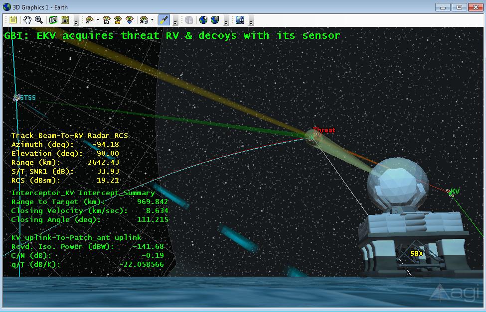
6 Stored View: 6_Kill_Vehicle: Communications & Sensors Modeling: Various targeted and fix sensors are modeled in the scenario to define communication links between assets and track the threat missile in this scenario; starting with the targeted Track_Sensor sensor object inserted on the STSS satellite. The sensor has a nominal range and grazing altitude constraint suitable for this long-range exo-atmospheric missile flight. The sensor begins tracking the threat missile shortly before the Re-entry Vehicle (RV) and decoys are released. Once the STSS satellite acquires the threat missile with its tracking sensor, it is able to simulate a comm downlink with the SBX radar with its targeted Gaussian

7 antenna transmitter. The Gaussian antenna pattern can be seen by zooming in on the STSS satellite object in the STK 3D window where you will also see a custom comm data display report on the left hand side of the 3D window. The STSS will also simulate a comm downlink to the Clear_AFB facility receiver to relay the threat missile trajectory prior to the Ground Base interceptor being launched near Kodiak, Ak. The Clear_AFB facility will also provide additional tracking of the threat missile with its defined complex sensor with a range of 4500 km. The sensor on the Kill Vehile (KV) ejected from the Ground Base Interceptor (GBI) missile simulates an infrared seeker which detects and track all incoming objects. Initially when the KV is deployed it uses it sensor to track the following stars (HR-213, HR-219, & HR-235) to orient itself before the intercept with the RV can take place. The maneuvers are done through the use of the Multi- Segment feature provided in the STK Attitude module. The KV is able to simulate the uplink of telemetry data from the Kodiak facility by using a Patch external antenna pattern generated in Pattern Magus. This software allows the ability for users to create their own custom external antenna files which can then be integrated for comm analysis between assets in STK. Radar Modeling: The Sea Based X-Band radar (SBX) ship object uses a targeted aperture configured radar with a designed frequency of 10 GHz and peak power of 90 dbw. The main and back lobe gains for the radar are 38.4 db and -30 db respectively. The Goal SNR is set at 16 db with a constant efficiency of.950. A minimum single pulse probability of detection Single Pulse Pdet constraint of 0.6 was applied to the radar for the purposes of tracking this threat missile. The Radar_Search_Track_Integrated_SNR2 quick report linked to the Track_Beam radar object on the SBX ship object shows the single pulse detection verse range plot to the RV object; users are able to see SNR value improves as the distance between the threat missile and the SBX radar decreases.


8 Intercept: The interceptor missile which intercepts the RV is this scenario is also created through the use of the MMT product. Stored views 5,6,7, & 8 provide several 3D shots of a potential intercept views. Once the KV is deployed users are able to see the intercept summary report data display on the left hand side of the STK 3D window which displays the range to the target, the closing velocity, and closing angle to the RV.This test is designed to evaluate the performance of a ground based radar tracking an incoming aircraft.
Synthetic Aperture Radar (SAR) Analysis with STK
 Analysis with STK") Synthetic Aperture Radar (SAR) Analysis with STK Problem Statement You are conducting an exercise testing a Spotlight Synthetic Aperture Radar (SAR) system over a ground site. An experimental satellite
Synthetic Aperture Radar (SAR) Analysis with STK Problem Statement You are conducting an exercise testing a Spotlight Synthetic Aperture Radar (SAR) system over a ground site. An experimental satellite
ASM(AR) Demonstration Engagements Anti-Ship Missile Active Radar Homing
 Demonstration Engagements Anti-Ship Missile Active Radar Homing") ASM(AR) Demonstration Engagements Anti-Ship Missile Active Radar Homing The demonstration scenarios are: 1) Demo_1: Anti-Ship missile versus target ship executing an evasive maneuver 2) Demo_2: Anti-Ship
ASM(AR) Demonstration Engagements Anti-Ship Missile Active Radar Homing The demonstration scenarios are: 1) Demo_1: Anti-Ship missile versus target ship executing an evasive maneuver 2) Demo_2: Anti-Ship
Design of a Free Space Optical Communication Module for Small Satellites
 Design of a Free Space Optical Communication Module for Small Satellites Ryan W. Kingsbury, Kathleen Riesing Prof. Kerri Cahoy MIT Space Systems Lab AIAA/USU Small Satellite Conference August 6 2014 Problem
CubeSat Integration into the Space Situational Awareness Architecture
 CubeSat Integration into the Space Situational Awareness Architecture Keith Morris, Chris Rice, Mark Wolfson Lockheed Martin Space Systems Company 12257 S. Wadsworth Blvd. Mailstop S6040 Littleton, CO
DRONACHARYA GROUP OF INSTITUTIONS, GREATER NOIDA. SATELLITE COMMUNICATIONS (EEC 021) QUESTION BANK
 QUESTION BANK") DRONACHARYA GROUP OF INSTITUTIONS, GREATER NOIDA. SATELLITE COMMUNICATIONS (EEC 021) QUESTION BANK 1. Write the advantages and disadvantages of Satellite Communication. 2. Distinguish between active and
DRONACHARYA GROUP OF INSTITUTIONS, GREATER NOIDA. SATELLITE COMMUNICATIONS (EEC 021) QUESTION BANK 1. Write the advantages and disadvantages of Satellite Communication. 2. Distinguish between active and
Primary POC: Prof. Hyochoong Bang Organization: Korea Advanced Institute of Science and Technology KAIST POC
 Title: Demonstration of Optical Stellar Interferometry with Near Earth Objects (NEO) using Laser Range Finder by a Nano Satellite Constellation: A Cost effective approach. Primary POC: Prof. Hyochoong
Uranus Exploration Challenges
 Uranus Exploration Challenges Steve Matousek Workshop on the Study of Icy Giant Planet (2014) July 30, 2014 (c) 2014 California Institute of Technology. Government sponsorship acknowledged. JPL URS clearance
Simulation of GPS-based Launch Vehicle Trajectory Estimation using UNSW Kea GPS Receiver
 Simulation of GPS-based Launch Vehicle Trajectory Estimation using UNSW Kea GPS Receiver Sanat Biswas Australian Centre for Space Engineering Research, UNSW Australia, s.biswas@unsw.edu.au Li Qiao School
Orbit Determination for CE5T Based upon GPS Data
 Orbit Determination for CE5T Based upon GPS Data Cao Jianfeng (1), Tang Geshi (2), Hu Songjie (3), ZhangYu (4), and Liu Lei (5) (1) Beijing Aerospace Control Center, 26 Beiqing Road, Haidian Disrtrict,
HEMERA Constellation of passive SAR-based micro-satellites for a Master/Slave configuration
 HEMERA Constellation of passive SAR-based micro-satellites for a Master/Slave HEMERA Team Members: Andrea Bellome, Giulia Broggi, Luca Collettini, Davide Di Ienno, Edoardo Fornari, Leandro Lucchese, Andrea
The Evolution of Nano-Satellite Proximity Operations In-Space Inspection Workshop 2017
 The Evolution of Nano-Satellite Proximity Operations 02-01-2017 In-Space Inspection Workshop 2017 Tyvak Introduction We develop miniaturized custom spacecraft, launch solutions, and aerospace technologies
RADIOMETRIC TRACKING. Space Navigation
 RADIOMETRIC TRACKING Space Navigation Space Navigation Elements SC orbit determination Knowledge and prediction of SC position & velocity SC flight path control Firing the attitude control thrusters to
NASDA S PRECISE ORBIT DETERMINATION SYSTEM
 NASDA S PRECISE ORBIT DETERMINATION SYSTEM Maki Maeda Takashi Uchimura, Akinobu Suzuki, Mikio Sawabe National Space Development Agency of Japan (NASDA) Sengen 2-1-1, Tsukuba, Ibaraki, 305-8505, JAPAN E-mail:
Final Examination. 22 April 2013, 9:30 12:00. Examiner: Prof. Sean V. Hum. All non-programmable electronic calculators are allowed.
 UNIVERSITY OF TORONTO FACULTY OF APPLIED SCIENCE AND ENGINEERING The Edward S. Rogers Sr. Department of Electrical and Computer Engineering ECE 422H1S RADIO AND MICROWAVE WIRELESS SYSTEMS Final Examination
Active microwave systems (1) Satellite Altimetry
 Satellite Altimetry") Remote Sensing: John Wilkin Active microwave systems (1) Satellite Altimetry jwilkin@rutgers.edu IMCS Building Room 214C 732-932-6555 ext 251 Active microwave instruments Scatterometer (scattering from
Remote Sensing: John Wilkin Active microwave systems (1) Satellite Altimetry jwilkin@rutgers.edu IMCS Building Room 214C 732-932-6555 ext 251 Active microwave instruments Scatterometer (scattering from
Istanbul Technical University Faculty of Aeronautics and Astronautics Space Systems Design and Test Laboratory
 Title: Space Advertiser (S-VERTISE) Primary POC: Aeronautics and Astronautics Engineer Hakan AYKENT Organization: Istanbul Technical University POC email: aykent@itu.edu.tr Need Worldwide companies need
Tailored Tactical Surveillance
 Mr. Tim Clark Program Manager Special Projects Office At our last DARPATech, the Special Projects Office (SPO) discussed the need for persistent global and theater surveillance and how, by advancing the
CubeSat Proximity Operations Demonstration (CPOD) Mission Update Cal Poly CubeSat Workshop San Luis Obispo, CA
 Mission Update Cal Poly CubeSat Workshop San Luis Obispo, CA") CubeSat Proximity Operations Demonstration (CPOD) Mission Update Cal Poly CubeSat Workshop San Luis Obispo, CA 04-22-2015 Austin Williams VP, Space Vehicles ConOps Overview - Designed to Maximize Mission
CubeSat Proximity Operations Demonstration (CPOD) Mission Update Cal Poly CubeSat Workshop San Luis Obispo, CA 04-22-2015 Austin Williams VP, Space Vehicles ConOps Overview - Designed to Maximize Mission
RADIOMETRIC TRACKING. Space Navigation
 RADIOMETRIC TRACKING Space Navigation October 24, 2016 D. Kanipe Space Navigation Elements SC orbit determination Knowledge and prediction of SC position & velocity SC flight path control Firing the attitude
Miguel A. Aguirre. Introduction to Space. Systems. Design and Synthesis. ) Springer
 Springer") Miguel A. Aguirre Introduction to Space Systems Design and Synthesis ) Springer Contents Foreword Acknowledgments v vii 1 Introduction 1 1.1. Aim of the book 2 1.2. Roles in the architecture definition
Miguel A. Aguirre Introduction to Space Systems Design and Synthesis ) Springer Contents Foreword Acknowledgments v vii 1 Introduction 1 1.1. Aim of the book 2 1.2. Roles in the architecture definition
Track Generation and Management Within ACES
 TRACK GENERATION AND MANAGEMENT WITHIN ACES Track Generation and Management Within ACES Chad W. Bates Rebecca J. Gassler Simon Moskowitz Michael J. Burke and Joshua M. Henly This article describes the
Satellite Engineering BEST Course. CubeSats at ULg
 Satellite Engineering BEST Course CubeSats at ULg Nanosatellite Projects at ULg Primary goal Hands-on satellite experience for students 2 Nanosatellite Projects at ULg Primary goal Hands-on satellite experience
Remote Sensing: John Wilkin IMCS Building Room 211C ext 251. Active microwave systems (1) Satellite Altimetry
 Satellite Altimetry") Remote Sensing: John Wilkin wilkin@marine.rutgers.edu IMCS Building Room 211C 732-932-6555 ext 251 Active microwave systems (1) Satellite Altimetry Active microwave instruments Scatterometer (scattering
Remote Sensing: John Wilkin wilkin@marine.rutgers.edu IMCS Building Room 211C 732-932-6555 ext 251 Active microwave systems (1) Satellite Altimetry Active microwave instruments Scatterometer (scattering
Deep Space Communication The further you go, the harder it gets. D. Kanipe, Sept. 2013
 Deep Space Communication The further you go, the harder it gets D. Kanipe, Sept. 2013 Deep Space Communication Introduction Obstacles: enormous distances, S/C mass and power limits International Telecommunications
Emergency Locator Signal Detection and Geolocation Small Satellite Constellation Feasibility Study
 Emergency Locator Signal Detection and Geolocation Small Satellite Constellation Feasibility Study Authors: Adam Gunderson, Celena Byers, David Klumpar Background Aircraft Emergency Locator Transmitters
Space Systems Engineering
 Space Systems Engineering This course studies the space systems engineering referring to spacecraft examples. It covers the mission analysis and design, system design approach, systems engineering process
debris manoeuvre by photon pressure
 Satellite target for demonstration of space debris manoeuvre by photon pressure Benjamin Sheard EOS Space Systems Pty. Ltd. / Space Environment Research Centre Space Environment Research Centre (SERC):
Air Force Institute of Technology. A CubeSat Mission for Locating and Mapping Spot Beams of GEO Comm-Satellites
 Air Force Institute of Technology A CubeSat Mission for Locating and Mapping Spot Beams of GEO Comm-Satellites Lt. Jake LaSarge PI: Dr. Jonathan Black Dr. Brad King Dr. Gary Duke August 9, 2015 1 Outline
Allen Guzik Trajectory. AAE 450 Spring 2008 Trajectory Optimization 1/25
 Allen Guzik Trajectory Trajectory Optimization 1/25 Delta V at Each Latitude Initial Assessment Only looks at Velocity gained from the rotation of the Earth Assume Launched Vertically and directly East
Development of Microsatellite to Detect Illegal Fishing MS-SAT
 Development of Microsatellite to Detect Illegal Fishing MS-SAT Ernest S. C. P. Bintang A.S.W.A.M. Department of Aerospace Engineering Faculty of Mechanical and Aerospace Engineering Institut Teknologi
SATELLITE TRACKING THROUGH THE ANALYSIS OF RADIATION PATTERNS
 1 SATELLITE TRACKING THROUGH THE ANALYSIS OF RADIATION PATTERNS David Olivera Mezquita Abstract This paper describes the process of tracking the trajectory of a satellite by analyzing the radiation pattern
GNSS Reflectometry and Passive Radar at DLR
 ACES and FUTURE GNSS-Based EARTH OBSERVATION and NAVIGATION 26./27. May 2008, TU München Dr. Thomas Börner, Microwaves and Radar Institute, DLR Overview GNSS Reflectometry a joined proposal of DLR and
High Speed Data Downlink for NSF Space Weather CubeSats
 High Speed Data Downlink for NSF Space Weather CubeSats National Science Foundation Meeting Monday August 31, 2009 Charles Swenson Satellite Data Flow Onboard Instruments R collected Spacecraft Memory
Chapter 4 The RF Link
 Chapter 4 The RF Link The fundamental elements of the communications satellite Radio Frequency (RF) or free space link are introduced. Basic transmission parameters, such as Antenna gain, Beamwidth, Free-space
Annex B: HEO Satellite Mission
 Annex B: HEO Satellite Mission Table of Content TABLE OF CONTENT...I 1. INTRODUCTION...1 1.1. General... 1 1.2. Response Guidelines... 1 2. BRAODBAND CAPACITY...2 2.1. Mission Overview... 2 2.1.1. HEO
1. Detect and locate potentially illegal fishing ship using satellite image, AIS data, and external sources.
 Title: Development of Microsatellite to Detect Illegal Fishing MS-SAT Primary Point of Contact (POC) & email: Dr. Ridanto Eko Poetro; ridanto@ae.itb.ac.id Co-authors: Ernest Sebastian C., Bintang A.S.W.A.M.
On January 14, 2004, the President announced a new space exploration vision for NASA
 Exploration Conference January 31, 2005 President s Vision for U.S. Space Exploration On January 14, 2004, the President announced a new space exploration vision for NASA Implement a sustained and affordable
Small Satellites: The Execution and Launch of a GPS Radio Occultation Instrument in a 6U Nanosatellite
 Small Satellites: The Execution and Launch of a GPS Radio Occultation Instrument in a 6U Nanosatellite Dave Williamson Director, Strategic Programs Tyvak Tyvak: Satellite Solutions for Multiple Organizations
Technician Licensing Class
 Technician Licensing Class Talk to Outer Presented Space by Amateur Radio Technician Class Element 2 Course Presentation ELEMENT 2 SUB-ELEMENTS (Groupings) About Ham Radio Call Signs Control Mind the Rules
Baumanets student micro-satellite
 Baumanets student micro-satellite Presentation at UNIVERSAT 2006 International Symposium June 28, 2006 Moscow, Russia Victoria Mayorova Director of Youth Space Center of Bauman Moscow State Technical University
Worst-Case GPS Constellation for Testing Navigation at Geosynchronous Orbit for GOES-R
 Worst-Case GPS Constellation for Testing Navigation at Geosynchronous Orbit for GOES-R Kristin Larson, Dave Gaylor, and Stephen Winkler Emergent Space Technologies and Lockheed Martin Space Systems 36
INTRODUCTION The validity of dissertation Object of investigation Subject of investigation The purpose: of the tasks The novelty:
 INTRODUCTION The validity of dissertation. According to the federal target program "Maintenance, development and use of the GLONASS system for 2012-2020 years the following challenges were determined:
The Analysis Module of ESA s Space Trajectory Analysis software
 The Analysis Module of ESA s Space Trajectory Analysis software Ana Margarida Teixeira Pinto Raposo Instituto Superior Técnico, Portugal, December 2010 Abstract- The use of simulation software has proven
RECOMMENDATION ITU-R SA.1628
 Rec. ITU-R SA.628 RECOMMENDATION ITU-R SA.628 Feasibility of sharing in the band 35.5-36 GHZ between the Earth exploration-satellite service (active) and space research service (active), and other services
36. Global Positioning System
 36. Introduction to the Global Positioning System (GPS) Why do we need GPS? Position: a basic need safe sea travel, crowed skies, resource management, legal questions Positioning: a challenging job local
GLOBAL POSITIONING SYSTEMS. Knowing where and when
 GLOBAL POSITIONING SYSTEMS Knowing where and when Overview Continuous position fixes Worldwide coverage Latitude/Longitude/Height Centimeter accuracy Accurate time Feasibility studies begun in 1960 s.
AN/ALE-55 Fiber-Optic Towed Decoy ELECTRONIC SYSTEMS
 AN/ALE-55 Fiber-Optic Towed Decoy ELECTRONIC SYSTEMS 1 Benefits Reliable protection against advanced RF threats High-power coherent jamming Rapid launch Stable flight across wide speed and altitude variations
SATELLITE SUBSYSTEMS. Networks and Communication Department. Dr. Marwah Ahmed
 1 SATELLITE SUBSYSTEMS Networks and Communication Department Dr. Marwah Ahmed Outlines Attitude and Orbit Control System (AOCS) Telemetry, Tracking, Command and Monitoring (TTC & M) Power System Communication
Tactical and Strategic Missile Guidance
 Israel Association for Automatic Control 5 Day Course 10-14 March 2013 Hotel Daniel, Herzliya Tactical and Strategic Missile Guidance Fee: 5000 NIS/participant for participants 1-20 from the same company
CubeSat Proximity Operations Demonstration (CPOD) Vehicle Avionics and Design
 Vehicle Avionics and Design") CubeSat Proximity Operations Demonstration (CPOD) Vehicle Avionics and Design August CubeSat Workshop 2015 Austin Williams VP, Space Vehicles CPOD: Big Capability in a Small Package Communications ADCS
CubeSat Proximity Operations Demonstration (CPOD) Vehicle Avionics and Design August CubeSat Workshop 2015 Austin Williams VP, Space Vehicles CPOD: Big Capability in a Small Package Communications ADCS
ECE 6390: Satellite Communications and Navigation Systems TEST 1 (Fall 2004)
") Name: GTID: ECE 6390: Satellite Communications and Navigation Systems TEST 1 (Fall 2004) Please read all instructions before continuing with the test. This is a closed notes, closed book, closed friend,
Name: GTID: ECE 6390: Satellite Communications and Navigation Systems TEST 1 (Fall 2004) Please read all instructions before continuing with the test. This is a closed notes, closed book, closed friend,
AIRSAM: A Tool for Assessing Airborne Infrared Countermeasures
 AIRSAM: A Tool for Assessing Airborne Infrared Countermeasures David Forrai Sverdrup Technology, Inc. 4200 Colonel Glenn Hwy. Beavercreek, OH 45431 937.429.5056 forraidp@sverdrup.com James Maier Air Force
Microsatellite Constellation for Earth Observation in the Thermal Infrared Region
 Microsatellite Constellation for Earth Observation in the Thermal Infrared Region Federico Bacci di Capaci Nicola Melega, Alessandro Tambini, Valentino Fabbri, Davide Cinarelli Observation Index 1. Introduction
Riza Muhida. Presented at he 22nd Session of the Asia Pacific Regional Space Agency Forum (APRSAF 22), Bali, Indonesia, December 1 4, 2015
, Bali, Indonesia, December 1 4, 2015") Riza Muhida Presented at he 22nd Session of the Asia Pacific Regional Space Agency Forum (APRSAF 22), Bali, Indonesia, December 1 4, 2015 1 Presentation Outline Abstract Background Objective Project Scope
Riza Muhida Presented at he 22nd Session of the Asia Pacific Regional Space Agency Forum (APRSAF 22), Bali, Indonesia, December 1 4, 2015 1 Presentation Outline Abstract Background Objective Project Scope
RAX: The Radio Aurora explorer
 RAX: Matt Bennett University of Michigan CubeSat Workshop Cal Poly, San Luis Obispo April 22 nd, 2009 Background Sponsored by National Science Foundation University of Michigan and SRI International Collaboration
MICROSCOPE Mission operational concept
 MICROSCOPE Mission operational concept PY. GUIDOTTI (CNES, Microscope System Manager) January 30 th, 2013 1 Contents 1. Major points of the operational system 2. Operational loop 3. Orbit determination
Chapter 13: Wave Propagation. EET-223: RF Communication Circuits Walter Lara
 Chapter 13: Wave Propagation EET-223: RF Communication Circuits Walter Lara Electrical to Electromagnetic Conversion Since the atmosphere is not a conductor of electrons (instead a good insulator), electrical
ExoMars and Beyond. Thales Alenia Space. Feb 28th, 9:00 AM. Follow this and additional works at: https://commons.erau.edu/space-congress-proceedings
 The Space Congress Proceedings 2018 (45th) The Next Great Steps Feb 28th, 9:00 AM ExoMars and Beyond Thales Alenia Space Follow this and additional works at: https://commons.erau.edu/space-congress-proceedings
The FAST, Affordable, Science and Technology Satellite (FASTSAT) Mission
 Mission") The FAST, Affordable, Science and Technology Satellite (FASTSAT) Mission 27 th Year of AIAA/USU Conference on Small Satellites, Small Satellite Constellations: Strength in Numbers, Session X: Year in Review
The FAST, Affordable, Science and Technology Satellite (FASTSAT) Mission 27 th Year of AIAA/USU Conference on Small Satellites, Small Satellite Constellations: Strength in Numbers, Session X: Year in Review
Introduction Objective and Scope p. 1 Generic Requirements p. 2 Basic Requirements p. 3 Surveillance System p. 3 Content of the Book p.
 Preface p. xi Acknowledgments p. xvii Introduction Objective and Scope p. 1 Generic Requirements p. 2 Basic Requirements p. 3 Surveillance System p. 3 Content of the Book p. 4 References p. 6 Maritime
Proximity Operations Nano-Satellite Flight Demonstration (PONSFD) Overview
 Overview") Proximity Operations Nano-Satellite Flight Demonstration (PONSFD) Overview April 25 th, 2013 Scott MacGillivray, President Tyvak Nano-Satellite Systems LLC 15265 Alton Parkway, Suite 200 Irvine, CA 92618-2606
Proximity Operations Nano-Satellite Flight Demonstration (PONSFD) Overview April 25 th, 2013 Scott MacGillivray, President Tyvak Nano-Satellite Systems LLC 15265 Alton Parkway, Suite 200 Irvine, CA 92618-2606
Chapter 3 Solution to Problems
 Chapter 3 Solution to Problems 1. The telemetry system of a geostationary communications satellite samples 100 sensors on the spacecraft in sequence. Each sample is transmitted to earth as an eight-bit
ATMOSPHERIC NUCLEAR EFFECTS
 EC3630 Radiowave Propagation ATMOSPHERIC NUCLEAR EFFECTS by Professor David Jenn (version 1.1) 1 Atmospheric Nuclear Effects (1) The effect of a nuclear blast on the atmosphere is a complicated function
CubeSat Advisors: Mechanical: Dr. Robert Ash ECE: Dr. Dimitrie Popescu 435 Team Members: Kevin Scott- Team Lead Robert Kelly- Orbital modeling and
 CubeSat Fall 435 CubeSat Advisors: Mechanical: Dr. Robert Ash ECE: Dr. Dimitrie Popescu 435 Team Members: Kevin Scott- Team Lead Robert Kelly- Orbital modeling and power Austin Rogers- Attitude control
Space Situational Awareness 2015: GPS Applications in Space
 Space Situational Awareness 2015: GPS Applications in Space James J. Miller, Deputy Director Policy & Strategic Communications Division May 13, 2015 GPS Extends the Reach of NASA Networks to Enable New
Small UAV Radiocommunication Channel Characterization
 Small UAV Radiocommunication Channel Characterization Jordi Romeu, Albert Aguasca, Javier Alonso, Sebastián Blanch, Ricardo R. Martins AntennaLab, Dpt. Signal Theory and Communications. Universitat Politecnica
Quantifying the Effects of Chaff Screening on Hardkill and Softkill Coordination
 Screening on Hardkill and Softkill Coordination Nekmohamed Manji, Murat Kocakanat, and Agis Kitsikis Defence R&D Canada Ottawa Department of National Defence 3701 Carling Ave Ottawa, ON, K1A 0Z4 CANADA
TELEMETRY CHALLENGES FOR BALLISTIC MISSILE TESTING IN THE CENTRAL PACIFIC
 TELEMETRY CHALLENGES FOR BALLISTIC MISSILE TESTING IN THE CENTRAL PACIFIC Item Type text; Proceedings Authors Markwardt, Jack; LaPoint, Steve Publisher International Foundation for Telemetering Journal
Project Bellerophon April 17, 2008
 Project Bellerophon April 17, 2008 Overview Telecommunications Flight Control Power Systems Vehicle Ground Data Processing Inputs Outputs Source Antennas Antennas Sensors Controls Supply Data Channels
Remote Sensing: John Wilkin IMCS Building Room 211C ext 251. Active microwave systems (1) Satellite Altimetry
 Satellite Altimetry") Remote Sensing: John Wilkin wilkin@marine.rutgers.edu IMCS Building Room 211C 732-932-6555 ext 251 Active microwave systems (1) Satellite Altimetry Active microwave instruments Scatterometer (scattering
Remote Sensing: John Wilkin wilkin@marine.rutgers.edu IMCS Building Room 211C 732-932-6555 ext 251 Active microwave systems (1) Satellite Altimetry Active microwave instruments Scatterometer (scattering
DHS/U.S. Customs and Border Protection -
 DHS/U.S. Customs and Border Protection - Technology Solutions Program Office (TSPO) DHS/ Unmanned Aircraft System (UAS) October 31, 2006 1 Purpose Provide overall UAS program overview Program Description
L-BAND ICE-PENETRATING RADAR ON BOARD A SMALL SATELLITE
 L-BAND ICE-PENETRATING RADAR ON BOARD A SMALL SATELLITE Anoop Parthasarathy Mtech. Digital Signal Processing Centre for Emerging Technologies Jain University ACKNOWLEDGEMENTS My sincere thanks to Dr. G.
CubeSat Communications Review and Concepts. Workshop, July 2, 2009
 CubeSat Communications Review and Concepts CEDAR CubeSats Constellations and Communications Workshop, July 2, 29 Charles Swenson Presentation Outline Introduction slides for reference Link Budgets Data
Satellite Testing. Prepared by. A.Kaviyarasu Assistant Professor Department of Aerospace Engineering Madras Institute Of Technology Chromepet, Chennai
 Satellite Testing Prepared by A.Kaviyarasu Assistant Professor Department of Aerospace Engineering Madras Institute Of Technology Chromepet, Chennai @copyright Solar Panel Deployment Test Spacecraft operating
Acoustic Based Angle-Of-Arrival Estimation in the Presence of Interference
 Acoustic Based Angle-Of-Arrival Estimation in the Presence of Interference Abstract Before radar systems gained widespread use, passive sound-detection based systems were employed in Great Britain to detect
NAVAL POSTGRADUATE SCHOOL THESIS
 NAVAL POSTGRADUATE SCHOOL MONTEREY, CALIFORNIA THESIS REQUIREMENTS AND LIMITATIONS OF BOOST PHASE BALLISTIC MISSILE INTERCEPT SYSTEMS by Kubilay Uzun September 2004 Thesis Advisor: Co Advisor: Phillip
AstroBus S, the high performance and competitive Small Satellites platform for Earth Observation
 AstroBus S, the high performance and competitive Small Satellites platform for Earth Observation Dr. Jean Cheganças 10th IAA Symposium on Small Satellites for Earth Observation April 20-24, 2015 Berlin,
Phoenix. A 3U CubeSat to Study Urban Heat Islands. Sarah Rogers - Project Manager NASA Space Grant Symposium April 14, 2018
 Phoenix A 3U CubeSat to Study Urban Heat Islands Sarah Rogers - Project Manager NASA Space Grant Symposium April 14, 2018 Phoenix Overview Undergraduate-led 3U CubeSat to study Urban Heat Islands through
Amateur Radio Satellites
 Amateur Radio Satellites An Introduction and Demo of AO-85 Eddie Pettis, N5JGK and Russ Tillman, K5NRK Presentation Outline History of Amateur Radio Satellites: Project OSCAR and AMSAT Amateur Radio Satellites
Keysight Technologies Virtual Flight Testing of Radar System Performance Using SystemVue and STK
 Keysight Technologies Virtual Flight Testing of Radar System Performance Using SystemVue and STK White Paper Abstract Keysight SystemVue (electronic system simulation) and AGI STK (inertial and environmental
Design of an Airborne SLAR Antenna at X-Band
 Design of an Airborne SLAR Antenna at X-Band Markus Limbach German Aerospace Center (DLR) Microwaves and Radar Institute Oberpfaffenhofen WFMN 2007, Markus Limbach, Folie 1 Overview Applications of SLAR
Platform Independent Launch Vehicle Avionics
 Platform Independent Launch Vehicle Avionics Small Satellite Conference Logan, Utah August 5 th, 2014 Company Introduction Founded in 2011 The Co-Founders blend Academia and Commercial Experience ~20 Employees
2009 Small Satellite Conference Logan, Utah
 Exploiting Link Dynamics in LEO-to-Ground Communications 2009 Small Satellite Conference Logan, Utah Joseph Palmer jmp@lanl.gov Michael Caffrey mpc@lanl.gov Los Alamos National Laboratory Paper Abstract
Module 3: Lecture 8 Standard Terminologies in Missile Guidance
 48 Guidance of Missiles/NPTEL/2012/D.Ghose Module 3: Lecture 8 Standard Terminologies in Missile Guidance Keywords. Latax, Line-of-Sight (LOS), Miss-Distance, Time-to-Go, Fire-and-Forget, Glint Noise,
Spectrum Sharing between High Altitude Platform and Fixed Satellite Networks in the 50/40 GHz band
 Spectrum Sharing between High Altitude Platform and Fixed Satellite Networks in the 50/40 GHz band Vasilis F. Milas, Demosthenes Vouyioukas and Prof. Philip Constantinou Mobile Radiocommunications Laboratory,
59TH ANNUAL FUZE CONFERENCE MAY 3-5, 2016 CHARLESTON, SC Fuzing Challenges for Guided Ammunition
 59TH ANNUAL FUZE CONFERENCE MAY 3-5, 2016 CHARLESTON, SC Fuzing Challenges for Guided Ammunition Introduction: Finmeccanica Guided Ammunition DART (Driven Ammunition Reduced Time-of-flight) Fired by Naval
X-band CubeSat Communication System Demonstration
 X-band CubeSat Communication System Demonstration Serhat Altunc, Obadiah Kegege, Steve Bundick, Harry Shaw, Scott Schaire, George Bussey, Gary Crum, Jacob C. Burke NASA Goddard Space Flight Center (GSFC)
JWST Functional Flow Diagrams and Schematic Block Diagrams
 CC532 Collaborate System Design Fundamentals of Systems Engineering W6, Spring, 2012 KAIST JWST Functional Flow Diagrams and Schematic Block Diagrams 1 JWST Operational s and System Functional Breakdown
A High-Speed Data Downlink for Wide-Bandwidth CubeSat Payloads
 A High-Speed Data Downlink for Wide-Bandwidth CubeSat Payloads John Buonocore 12 th Annual Developer s Workshop 22 April 2015 Cal Poly San Luis Obispo High Speed Data Downlink The need for wider bandwidth
VSAT (Very Small Aperture Terminal) TRAINING. 25 Hrs / 2 Weeks / Customized. DP Project Development Pvt. Ltd.
 TRAINING. 25 Hrs / 2 Weeks / Customized. DP Project Development Pvt. Ltd.") VSAT (Very Small Aperture Terminal) TRAINING A very small aperture terminal (VSAT), is a two-way satellite ground station or a stabilized maritime VSAT antenna with a dish antenna that smaller than 3 meters.
VSAT (Very Small Aperture Terminal) TRAINING A very small aperture terminal (VSAT), is a two-way satellite ground station or a stabilized maritime VSAT antenna with a dish antenna that smaller than 3 meters.
Improving CubeSat Communications
 Improving CubeSat Communications Nestor Voronka, Tyrel Newton, Alan Chandler, Peter Gagnon, Nate Storrs, Jory St.Luise, Rob Hoyt Tethers Unlimited, Inc. 11711 N. Creek Pkwy S., Suite D113 Bothell, WA 98011
Basic Satellite Communication. Thaicom Customer and Network Services Department
 Basic Satellite Communication Thaicom Customer and Network Services Department Satellite Communication System Control & Monitoring Station Satellite Space Segment Uplink Signals Downlink Signals Receive
Satellite Communications System
 Satellite Communications System Capacity Allocation Multiplexing Transponders Applications Maria Leonora Guico Tcom 126 Lecture 13 Capacity Allocation Strategies Frequency division multiple access (FDMA)
Post-Flight Analysis of the Radio Doppler Shifts of the ExoMars Schiaparelli Lander
 Post-Flight Analysis of the Radio Doppler Shifts of the ExoMars Schiaparelli Lander Ö. Karatekin 1, B. Van Hove 1, N. Gerbal 1, S. Asmar 2, D. Firre 3, M. Denis 3, A. Aboudan 4, F. Ferri 4 and AMELIA team
Active microwave systems (2) Satellite Altimetry * range data processing * applications
 Satellite Altimetry * range data processing * applications") Remote Sensing: John Wilkin wilkin@marine.rutgers.edu IMCS Building Room 211C 732-932-6555 ext 251 Active microwave systems (2) Satellite Altimetry * range data processing * applications Satellite Altimeters
Remote Sensing: John Wilkin wilkin@marine.rutgers.edu IMCS Building Room 211C 732-932-6555 ext 251 Active microwave systems (2) Satellite Altimetry * range data processing * applications Satellite Altimeters
2013 RockSat-C Preliminary Design Review
 2013 RockSat-C Preliminary Design Review TEC (The Electronics Club) Eastern Shore Community College Melfa, VA Larry Brantley, Andrew Carlton, Chase Riley, Nygel Meece, Robert Williams Date 10/26/2012 Mission
Presentation to CDW Niels Jernes Vej Aalborg E - Denmark - Phone:
 Presentation to CDW 2014 GomSpace at a Glance A space company situated in Denmark Nano-satellite products & platforms Micro-satellites (tailored products) Re-entry systems & micro-gravity R&D Established
National Aerospace Initiative
 National Aerospace Initiative Dr. Ron Sega Dr. Ron Sega Director, Defense Research & Engineering NATIONAL AEROSPACE INITIATIVE Agenda Background Transformation The National Aerospace Initiative (NAI) Overview
Introduction to Radar Systems. The Radar Equation. MIT Lincoln Laboratory _P_1Y.ppt ODonnell
 Introduction to Radar Systems The Radar Equation 361564_P_1Y.ppt Disclaimer of Endorsement and Liability The video courseware and accompanying viewgraphs presented on this server were prepared as an account
RECOMMENDATION ITU-R SA.1624 *
 Rec. ITU-R SA.1624 1 RECOMMENDATION ITU-R SA.1624 * Sharing between the Earth exploration-satellite (passive) and airborne altimeters in the aeronautical radionavigation service in the band 4 200-4 400