«Navi-Campus» : an orientation and navigation app for helping visually impaired people to walk independently on any university campus
|
|
|
- Louise Barber
- 6 years ago
- Views:
Transcription


1 «Navi-Campus» : an orientation and navigation app for helping visually impaired people to walk independently on any university campus Jesus ZEGARRA FLORES Altran Research Medic@ Laurence RASSENEUR Université Strasbourg Marie Odile HEMERLIN Université Strasbourg Catherine PEYRANI René FARCY Association d aveugles d Alsace Université Paris Sud Laboratoire Aimé Cotton
2 State of the art Use of Talk Back or Voice Over accessibility layer to give the vocal instructions (phone interaction and navigation app) Human Machine Interface (HMI) for entering addresses. Guidance information heading and distance or first to the right, etc.. Examples of current GPS devices: Trekker (2004) Navigon Mobile Navigator (2009) Kapten Mobility (2012) Via Opta Nav (Information turn right, etc.) (last version, may 2016) BlindSquare (Distance & heading information, points of interests) (last version june 2017) Ariadne GPS for iphone (Distance & heading ) (july 2016)
3 Problems of the GPS heading in urban areas Heading GPS walking displacement Heading GPS in a car
4 Problems of the GPS heading in case of hesitation m 90 6 mètres
5 Practical orientation problems with current devices If you only meet right angle intersections, if you never take the wrong way, if your starting point is not a large place etc. you will arrive at destination. In case of punctual hesitation, of an Y intersection, of a large place to cross etc you will be definitively lost.
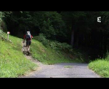
6 Specific Work Merge of GPS antennas, compasses and inertial sensors in Smartphones in order to give instant updated orientation to visually impaired people in Urban environments : Naviurbain Hiking environments : Navirando Large private facilities as campuses : Navicampus We will present the outcome of instant orientation, and the specific problems of mapping on a campus.


")

7 Materials Prototype developed in a ios operative system and Android. Programming in Objective C (X code) and JAVA. Devices which come with sensors: GPS, compass, accelerometer and gyrometers.
8 Results: improving heading information in case of hesitation Routes Real heading ( ) Maximu m error ( ) heading GPS Standard deviatio n heading GPS Maxim um error ( ) headin g IMU Standard deviation heading IMU route A-B route B-C route C-D route D-A route A-C route C-A route A-E


9 Interface The app uses the «heading» and «distance» information because it takes into account the axis displacement of the person and also the change of direction. It has been used the «heading» given by the compass coupled to the gyroscope and GPS. Heading and distance : case 1: 9 o clock 150 meters ; case 2: 6 o clock 150 meters 30 meters before the current point, information to the next point
10
11 Body axis Basic guidance : Point 3 3 o clock 150 meters Law faculty Basic guidance : point 3 12 o clock 150 meters Information for buildings at less than 50 meters : Law Faculty on the right Point 3 X Advance guidance : point 3 12 o clock, 150 meters + Advance Information : Route at 3 o clock X Spatial representation and anticipation training


12 Problems about cartography In some GPS devices, the GPS coordinates found from a faculty building address do not correspond to the real entrance (the path does not exist). Google does not enter in private facilities. Google position Real position 90 meters

13 Adapted cartography In order to have a good cartography adapted to the visually impaired displacements: - All public entries of buildings are identified - All practicable segments of routes are identified - Path finding using Dijkstra algorithm, the paths generated priories the main roads which have good haptic feedbacks for the white cane.
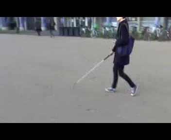
14 Test with a visual impaired student Person always accompanied, the purpose is to reach autonomy in the campus Previous basic mobility course We have taken the information from the speed of the GPS, 10 meters before and 10 meter after each turn (T1 T2 T3, etc.) in order to have an average speed. The efficiency in a turn is obtained by using: average speed in the turn / average speed in a straight line. The average speed in straight line is: 3km/h.
 :")
: T6: 90 turn T7: 90 turn T8: 90")
15 Campus Esplanade Test Escarpe to Cafétéria Chimie (688 m): T1: 90 turn T2: 90 turn T3: 90 turn Cafétéria Chimie to Pangloss (438m) : T4: <45 turn T5: 90 turn in a small square 25 m2 Pangloss to Institue Physique de Globe (588m): T6: 90 turn T7: 90 turn T8: 90 turn T9: 90 turn
16
17 Results: 1 st path : Escarpe to Cafétéria Chimie (15min 46 seconds) 2 nd path : Cafétéria Chimie to Pangloss (17min 25 seconds) 3 rd path Pangloss to Institute de Physique de Globe (11min 25seconds) km/h Efficiency % T1 2,73 91% T2 2,11 70% T3 2,15 71% T4 1,53 51% T5 1,74 58% T6 2,27 75% T7 2,32 77% T8 2,42 80% T9 2,5 83%
18 51% 58% T4 : the person did not take the road to the left. T5: the person hesitated because of the small square
19 Conclusions Merging GPS heading with compass and gyroscope improve the heading information in case of hesitation. Instant updated information relatively to body axis can extend GPS use to complex environments. Training is important to be efficient in merging GPS information with his own sensorial information. To extend mobility and maintain security is the challenge.
A MOBILE SOLUTION TO HELP VISUALLY IMPAIRED PEOPLE IN PUBLIC TRANSPORTS AND IN PEDESTRIAN WALKS
 D. Brito, et al., Int. J. Sus. Dev. Plann. Vol. 13, No. 2 (2018) 281 293 A MOBILE SOLUTION TO HELP VISUALLY IMPAIRED PEOPLE IN PUBLIC TRANSPORTS AND IN PEDESTRIAN WALKS D. BRITO, T. VIANA, D. SOUSA, A.
Outdoor Navigation Systems to Promote Urban Mobility to Aid Visually Impaired People
 Journal of Information Systems Engineering & Management, 2018, 3(2), 14 ISSN: 2468-4376 Outdoor Navigation Systems to Promote Urban Mobility to Aid Visually Impaired People André Lima 1, Daniela Mendes
Hardware-free Indoor Navigation for Smartphones
 Hardware-free Indoor Navigation for Smartphones 1 Navigation product line 1996-2015 1996 1998 RTK OTF solution with accuracy 1 cm 8-channel software GPS receiver 2004 2007 Program prototype of Super-sensitive
idocent: Indoor Digital Orientation Communication and Enabling Navigational Technology
 idocent: Indoor Digital Orientation Communication and Enabling Navigational Technology Final Proposal Team #2 Gordie Stein Matt Gottshall Jacob Donofrio Andrew Kling Facilitator: Michael Shanblatt Sponsor:
Remote PED Assistant. Gabriel DeRuwe. Department of Electrical & Computer Engineering
 Remote PED Assistant Gabriel DeRuwe NIATT Department of Electrical & Computer Engineering Smart Signals Research Advanced Pedestrian Assistant What is it: A handheld device for activation of pedestrian
NAV CAR Lane-sensitive positioning and navigation for innovative ITS services AMAA, May 31 st, 2012 E. Schoitsch, E. Althammer, R.
 NAV CAR Lane-sensitive positioning and navigation for innovative ITS services AMAA, May 31 st, 2012 E. Schoitsch, E. Althammer, R. Kloibhofer (AIT), R. Spielhofer, M. Reinthaler, P. Nitsche (ÖFPZ), H.
Indoor Positioning 101 TECHNICAL)WHITEPAPER) SenionLab)AB) Teknikringen)7) 583)30)Linköping)Sweden)
WHITEPAPER) SenionLab)AB) Teknikringen)7) 583)30)Linköping)Sweden)") Indoor Positioning 101 TECHNICAL)WHITEPAPER) SenionLab)AB) Teknikringen)7) 583)30)Linköping)Sweden) TechnicalWhitepaper)) Satellite-based GPS positioning systems provide users with the position of their
Indoor Positioning 101 TECHNICAL)WHITEPAPER) SenionLab)AB) Teknikringen)7) 583)30)Linköping)Sweden) TechnicalWhitepaper)) Satellite-based GPS positioning systems provide users with the position of their
BeFitter Apps Manual
 BeFitter Apps Manual Key features The apps BF Hiker, BF Cycle, BF XC Ski and BF Runner have 13 pages. You can toggle through these pages with the previous page and next page function. See the chapter User
Precise Positioning with Smartphones running Android 7 or later
 Precise Positioning with Smartphones running Android 7 or later * René Warnant, * Cécile Deprez, + Quentin Warnant * University of Liege Geodesy and GNSS + Augmenteo, Plaine Image, Lille (France) Belgian
Chapter 2 Outdoor Navigation
 Chapter 2 Outdoor Navigation 2.1 Introduction In this chapter, the technologies and techniques that are employed in outdoor navigation systems/services along with their features and users are discussed.
Concept of the application supporting blind and visually impaired people in public transport
 Academia Journal of Educational Research 5(12): 472-476, December 2017 DOI: 10.15413/ajer.2017.0714 ISSN 2315-7704 2017 Academia Publishing Research Paper Concept of the application supporting blind and
Team members: Christopher A. Urquhart Oluwaseyitan Joshua Durodola Nathaniel Sims
 Team members: Christopher A. Urquhart Oluwaseyitan Joshua Durodola Nathaniel Sims Background Problem Formulation Current State of Art Solution Approach Systematic Approach Task and Project Management Costs
Location and navigation system for visually impaired
 Česky Paper: # 8/11/2002 ISSN 1213-161X Content Location and navigation system for visually impaired Václav Eksler *), Genevičve Baudoin *)), Martine Villegas *)) Department of Telecommunications Faculty
Multi-sensory Tracking of Elders in Outdoor Environments on Ambient Assisted Living
 Multi-sensory Tracking of Elders in Outdoor Environments on Ambient Assisted Living Javier Jiménez Alemán Fluminense Federal University, Niterói, Brazil jjimenezaleman@ic.uff.br Abstract. Ambient Assisted
Utility of Sensor Fusion of GPS and Motion Sensor in Android Devices In GPS- Deprived Environment
 Utility of Sensor Fusion of GPS and Motion Sensor in Android Devices In GPS- Deprived Environment Amrit Karmacharya1 1 Land Management Training Center Bakhundol, Dhulikhel, Kavre, Nepal Tel:- +977-9841285489
From Room Instrumentation to Device Instrumentation: Assessing an Inertial Measurement Unit for Spatial Awareness
 From Room Instrumentation to Device Instrumentation: Assessing an Inertial Measurement Unit for Spatial Awareness Alaa Azazi, Teddy Seyed, Frank Maurer University of Calgary, Department of Computer Science
On Attitude Estimation with Smartphones
 On Attitude Estimation with Smartphones Thibaud Michel Pierre Genevès Hassen Fourati Nabil Layaïda Université Grenoble Alpes, INRIA LIG, GIPSA-Lab, CNRS March 16 th, 2017 http://tyrex.inria.fr/mobile/benchmarks-attitude
A VIRTUAL VALIDATION ENVIRONMENT FOR THE DESIGN OF AUTOMOTIVE SATELLITE BASED NAVIGATION SYSTEMS FOR URBAN CANYONS
 49. Internationales Wissenschaftliches Kolloquium Technische Universität Ilmenau 27.-30. September 2004 Holger Rath / Peter Unger /Tommy Baumann / Andreas Emde / David Grüner / Thomas Lohfelder / Jens
Technology offer. Aerial obstacle detection software for the visually impaired
 Technology offer Aerial obstacle detection software for the visually impaired Technology offer: Aerial obstacle detection software for the visually impaired SUMMARY The research group Mobile Vision Research
Algorithm for blind navigation along a GPS track
 Algorithm for blind navigation along a GPS track Rosen Ivanov Abstract: Most of existing navigation systems for the blind require a precise GPS maps. This makes them unusable in regions where there are
CENG 5931 HW 5 Mobile Robotics Due March 5. Sensors for Mobile Robots
 CENG 5931 HW 5 Mobile Robotics Due March 5 Sensors for Mobile Robots Dr. T. L. Harman: 281 283-3774 Office D104 For reports: Read HomeworkEssayRequirements on the web site and follow instructions which
Buddy Bearings: A Person-To-Person Navigation System
 Buddy Bearings: A Person-To-Person Navigation System George T Hayes School of Information University of California, Berkeley 102 South Hall Berkeley, CA 94720-4600 ghayes@ischool.berkeley.edu Dhawal Mujumdar
PERSONS AND OBJECTS LOCALIZATION USING SENSORS
 Investe}te în oameni! FONDUL SOCIAL EUROPEAN Programul Operational Sectorial pentru Dezvoltarea Resurselor Umane 2007-2013 eng. Lucian Ioan IOZAN PhD Thesis Abstract PERSONS AND OBJECTS LOCALIZATION USING
Smart Space - An Indoor Positioning Framework
 Smart Space - An Indoor Positioning Framework Droidcon 09 Berlin, 4.11.2009 Stephan Linzner, Daniel Kersting, Dr. Christian Hoene Universität Tübingen Research Group on Interactive Communication Systems
PerSec. Pervasive Computing and Security Lab. Enabling Transportation Safety Services Using Mobile Devices
 PerSec Pervasive Computing and Security Lab Enabling Transportation Safety Services Using Mobile Devices Jie Yang Department of Computer Science Florida State University Oct. 17, 2017 CIS 5935 Introduction
Introduction...3. System Overview...4. Navigation Computer GPS Antenna...6. Speed Signal...6 MOST RGB Lines...6. Navigation Display...
 Table of Contents E65 NAVIGATION SYSTEM Subject Page Introduction...............................................3 System Overview...........................................4 Components Navigation Computer.....................................
Sponsored by. Nisarg Kothari Carnegie Mellon University April 26, 2011
 Sponsored by Nisarg Kothari Carnegie Mellon University April 26, 2011 Motivation Why indoor localization? Navigating malls, airports, office buildings Museum tours, context aware apps Augmented reality
International Journal OF Engineering Sciences & Management Research
 EMBEDDED MICROCONTROLLER BASED REAL TIME SUPPORT FOR DISABLED PEOPLE USING GPS Ravi Sankar T *, Ashok Kumar K M.Tech, Dr.M.Narsing Yadav M.S.,Ph.D(U.S.A) * Department of Electronics and Computer Engineering,
Smart Navigation System for Visually Impaired Person
 Smart Navigation System for Visually Impaired Person Rupa N. Digole 1, Prof. S. M. Kulkarni 2 ME Student, Department of VLSI & Embedded, MITCOE, Pune, India 1 Assistant Professor, Department of E&TC, MITCOE,
Easy-OBU Project. The Easy-OBU way to bridge GNSS outages
 Easy-OBU Project The Easy-OBU way to bridge GNSS outages Easy-OBU research project in a nutshell: GSA supported international project aimed at an introduction of cheap positioning solution with improved
24-27 september 2018 Cité des congrès de Nantes
 Press kit IPIN 2018 24-27 september 2018 Cité des congrès de Nantes The sponsors Media partner 1 Editorial Creating continuity between outdoor and indoor navigation systems By Valérie Renaudin, director
Indoor Positioning by the Fusion of Wireless Metrics and Sensors
 Indoor Positioning by the Fusion of Wireless Metrics and Sensors Asst. Prof. Dr. Özgür TAMER Dokuz Eylül University Electrical and Electronics Eng. Dept Indoor Positioning Indoor positioning systems (IPS)
Integrated Driving Aware System in the Real-World: Sensing, Computing and Feedback
 Integrated Driving Aware System in the Real-World: Sensing, Computing and Feedback Jung Wook Park HCI Institute Carnegie Mellon University 5000 Forbes Avenue Pittsburgh, PA, USA, 15213 jungwoop@andrew.cmu.edu
Senion IPS 101. An introduction to Indoor Positioning Systems
 Senion IPS 101 An introduction to Indoor Positioning Systems INTRODUCTION Indoor Positioning 101 What is Indoor Positioning Systems? 3 Where IPS is used 4 How does it work? 6 Diverse Radio Environments
Touch Your Way: Haptic Sight for Visually Impaired People to Walk with Independence
 Touch Your Way: Haptic Sight for Visually Impaired People to Walk with Independence Ji-Won Song Dept. of Industrial Design. Korea Advanced Institute of Science and Technology. 335 Gwahangno, Yusong-gu,
Algorithm for GPS Navigation, Adapted for Visually Impaired People
 Algorithm for GPS Navigation, Adapted for Visually Impaired People Rosen S. Ivanov Abstract The paper presents an algorithm for speech enabled GPS navigation in Bulgarian. The algorithm is part of the
ADMA. Automotive Dynamic Motion Analyzer with 1000 Hz. ADMA Applications. State of the art: ADMA GPS/Inertial System for vehicle dynamics testing
 ADMA Automotive Dynamic Motion Analyzer with 1000 Hz State of the art: ADMA GPS/Inertial System for vehicle dynamics testing ADMA Applications The strap-down technology ensures that the ADMA is stable
Using Intelligent Mobile Devices for Indoor Wireless Location Tracking, Navigation, and Mobile Augmented Reality
 Using Intelligent Mobile Devices for Indoor Wireless Location Tracking, Navigation, and Mobile Augmented Reality Chi-Chung Alan Lo, Tsung-Ching Lin, You-Chiun Wang, Yu-Chee Tseng, Lee-Chun Ko, and Lun-Chia
AN UNIQUE METHODOLOGY ENABLING BUS BOARD NAVIGATING SYSTEM USING WSN
 AN UNIQUE METHODOLOGY ENABLING BUS BOARD NAVIGATING SYSTEM USING WSN Ms.R.Madhumitha [1], N.Nandhini [2], R.Rajalakshmi [3], K.Raja Rajeswari [4]. [1] UG Student, Department of ECE,Panimalar Engineering
The Jigsaw Continuous Sensing Engine for Mobile Phone Applications!
 The Jigsaw Continuous Sensing Engine for Mobile Phone Applications! Hong Lu, Jun Yang, Zhigang Liu, Nicholas D. Lane, Tanzeem Choudhury, Andrew T. Campbell" CS Department Dartmouth College Nokia Research
Satellite and Inertial Attitude. A presentation by Dan Monroe and Luke Pfister Advised by Drs. In Soo Ahn and Yufeng Lu
 Satellite and Inertial Attitude and Positioning System A presentation by Dan Monroe and Luke Pfister Advised by Drs. In Soo Ahn and Yufeng Lu Outline Project Introduction Theoretical Background Inertial
ANNUAL OF NAVIGATION 16/2010
 ANNUAL OF NAVIGATION 16/2010 STANISŁAW KONATOWSKI, MARCIN DĄBROWSKI, ANDRZEJ PIENIĘŻNY Military University of Technology VEHICLE POSITIONING SYSTEM BASED ON GPS AND AUTONOMIC SENSORS ABSTRACT In many real
Micro-Technology for Positioning, Navigation and Timing
 Micro-Technology for Positioning, Navigation and Timing (µpnt) Dr. Program Manager DARPA/MTO Aggregation Overall goal: Enable self-contained chip-scale inertial navigation Reduce SWaP of existing Inertial
IoT Wi-Fi- based Indoor Positioning System Using Smartphones
 IoT Wi-Fi- based Indoor Positioning System Using Smartphones Author: Suyash Gupta Abstract The demand for Indoor Location Based Services (LBS) is increasing over the past years as smartphone market expands.
CCNY Smart Cane. Qingtian Chen 1, Muhammad Khan 1, Christina Tsangouri 2, Christopher Yang 2, Bing Li 1, Jizhong Xiao 1* and Zhigang Zhu 2*
 The 7th Annual IEEE International Conference on Cyber Technology in Automation, Control and Intelligent Systems July 31-August 4, 2017, Hawaii, USA CCNY Smart Cane Qingtian Chen 1, Muhammad Khan 1, Christina
Mobile Sensing: Opportunities, Challenges, and Applications
 Mobile Sensing: Opportunities, Challenges, and Applications Mini course on Advanced Mobile Sensing, November 2017 Dr Veljko Pejović Faculty of Computer and Information Science University of Ljubljana Veljko.Pejovic@fri.uni-lj.si
Sensing self motion. Key points: Why robots need self-sensing Sensors for proprioception in biological systems in robot systems
 Sensing self motion Key points: Why robots need self-sensing Sensors for proprioception in biological systems in robot systems Position sensing Velocity and acceleration sensing Force sensing Vision based
Hack Your Ride With Beacon Technology!
 Hack Your Ride With Beacon Technology! #kontakt_io Trevor Longino Head of Marketing & PR @trevorlongino @kontakt_io We help build the world s best proximity solutions 10 thousand+ clients! Welcome to the
Fire Fighter Location Tracking & Status Monitoring Performance Requirements
 Fire Fighter Location Tracking & Status Monitoring Performance Requirements John A. Orr and David Cyganski orr@wpi.edu, cyganski@wpi.edu Electrical and Computer Engineering Department Worcester Polytechnic
A Survey of UAS Industry Professionals to Guide Program Improvement
 A Survey of Industry Professionals to Guide Program Improvement Saeed M. Khan Kansas State University, Polytechnic Campus Abstract The engineering technology unmanned systems option (ET-US) of K-State
Introduction to Mobile Sensing Technology
 Introduction to Mobile Sensing Technology Kleomenis Katevas k.katevas@qmul.ac.uk https://minoskt.github.io Image by CRCA / CNRS / University of Toulouse In this talk What is Mobile Sensing? Sensor data,
Acoustic INS aiding NASNet & PHINS
 NAUTRONIX MARINE TECHNOLOGY SOLUTIONS Acoustic INS aiding NASNet & PHINS Sam Hanton Aberdeen Houston Rio Positioning Options Satellites GPS, GLONASS, COMPASS Acoustics LBL, SBL, USBL Relative sensors Laser
PROTECTING GPS/GNSS-RELIANT MILITARY SYSTEMS
 PROTECTING GPS/GNSS-RELIANT MILITARY SYSTEMS John Fischer VP Advanced R&D Jon Sinden Product Manager, Rugged PNT 6/21/2018 ABOUT OROLIA A world leader in assured positioning, navigation and timing (PNT)
Cooperative navigation (part II)
") Cooperative navigation (part II) An example using foot-mounted INS and UWB-transceivers Jouni Rantakokko Aim Increased accuracy during long-term operations in GNSS-challenged environments for - First responders
Cooperative navigation (part II) An example using foot-mounted INS and UWB-transceivers Jouni Rantakokko Aim Increased accuracy during long-term operations in GNSS-challenged environments for - First responders
TEST DATA, DEMONSTRATION VIDEOS, AND TRANSCEIVERS
 PRODUCT 0-6838-P1 TXDOT PROJECT NUMBER 0-6838 TEST DATA, DEMONSTRATION VIDEOS, AND TRANSCEIVERS Christian Claudel Paul Avery Kara Kockelman CENTER FOR TRANSPORTATION RESEARCH BUREAU OF ENGINEERING RESEARCH
A Novel Tracking System for AAL Based on Smartphone Technology. DIEEI University of Catania, Italy
 A Novel Tracking System for AAL Based on Smartphone Technology DIEEI University of Catania, Italy Outline AAL research activities at DIEEI The proposed methodology for user tracking The proposed methodology
High-accuracy Indoor Positioning Project - Providing assistance for everyone to avoid stress to travel
 High-accuracy Indoor Positioning Project - Providing assistance for everyone to avoid stress to travel March 7 th, 2017 Naoya AOTO Director, National Land Information Division, National Spatial Planning
Multi-Modal User Interaction
 Multi-Modal User Interaction Lecture 4: Multiple Modalities Zheng-Hua Tan Department of Electronic Systems Aalborg University, Denmark zt@es.aau.dk MMUI, IV, Zheng-Hua Tan 1 Outline Multimodal interface
GPS-Aided INS Datasheet Rev. 2.7
 1 The Inertial Labs Single and Dual Antenna GPS-Aided Inertial Navigation System INS is new generation of fully-integrated, combined GPS, GLONASS, GALILEO, QZSS and BEIDOU navigation and highperformance
Classical Control Based Autopilot Design Using PC/104
 Classical Control Based Autopilot Design Using PC/104 Mohammed A. Elsadig, Alneelain University, Dr. Mohammed A. Hussien, Alneelain University. Abstract Many recent papers have been written in unmanned
Ohio State University, Partners Develop 'Smart Paint' to Help the Visually Impaired Navigate Cities
 p. 1 Ohio State University, Partners Develop 'Smart Paint' to Help the Visually Impaired Navigate Cities Ben Levine February 12, 2018 In this installment of the Innovation of the Month series (read last
IOT GEOLOCATION NEW TECHNICAL AND ECONOMICAL OPPORTUNITIES
 IOT GEOLOCATION NEW TECHNICAL AND ECONOMICAL OPPORTUNITIES Florian LECLERE f.leclere@kerlink.fr EOT Conference Herning 2017 November 1st, 2017 AGENDA 1 NEW IOT PLATFORM LoRa LPWAN Platform Geolocation
SPEEDBOX Technical Datasheet
 SPEEDBOX Technical Datasheet Race Technology Limited, 2008 Version 1.1 1. Introduction... 3 1.1. Product Overview... 3 1.2. Applications... 3 1.3. Standard Features... 3 2. Port / Connector details...
Evaluating EGNOS technology in an ITS driving assistance application
 Evaluating EGNOS technology in an ITS driving assistance application A. Gómez Skarmeta H. Martínez Barberá M. Zamora Izquierdo J. Cánovas Quiñonero L. Tomás Balibrea Dept. of Communications and Information
Cooperative navigation: outline
 Positioning and Navigation in GPS-challenged Environments: Cooperative Navigation Concept Dorota A Grejner-Brzezinska, Charles K Toth, Jong-Ki Lee and Xiankun Wang Satellite Positioning and Inertial Navigation
SYSTEM OF IDENTIFICATION AND INFORMATION OF BLIND AND VISUALLY IMPAIRED PERSONS IN THE TRAFFIC NETWORK
 SYSTEM OF IDENTIFICATION AND INFORMATION OF BLIND AND VISUALLY IMPAIRED PERSONS IN THE TRAFFIC NETWORK Dragan Peraković 1 - Marko Periša 2 - Tina Runjić 3 Abstract: The mobility of visually impaired persons
Landmark-based Navigation System for Mobile Devices Have No Built-in GPS Receiver and Compass
 Landmark-based Navigation System for Mobile Devices Have No Built-in GPS Receiver and Compass Min-Chang Wu Chung-Yuan Christian University 2, Chung Pei Rd., Chung Li, Maiga Chang Athabasca University 2,
Webinar. 9 things you should know about centimeter-level GNSS accuracy
 Webinar 9 things you should know about centimeter-level GNSS accuracy Webinar agenda 9 things you should know about centimeter-level GNSS accuracy 1. High precision GNSS challenges 2. u-blox F9 technology
and Vehicle Sensors in Urban Environment
 AvailabilityImprovement ofrtk GPS GPSwithIMU and Vehicle Sensors in Urban Environment ION GPS/GNSS 2012 Tk Tokyo University it of Marine Si Science and Technology Nobuaki Kubo, Chen Dihan 1 Contents Background
GPS Apps for Smart Phone and PC YHA Bushwalking Club Night Presentation. Lutz Lademann May 2016
 GPS Apps for Smart Phone and PC YHA Bushwalking Club Night Presentation Lutz Lademann walks@lademann.de May 2016 Content How Does GPS Work What are GPX Files Where to Find GPX Files/Tracks/Walks How to
Formula Student Racing Championship: Design and implementation of an automatic localization and trajectory tracking system
 Formula Student Racing Championship: Design and implementation of an automatic localization and trajectory tracking system Diogo Carvalho diogo.carvalho@ist.utl.pt Instituto Superior Técnico Abstract.
GPS-free Geolocation using LoRa in Low-Power WANs. Bernat Carbonés Fargas, Martin Nordal Petersen 08/06/2017
 GPS-free Geolocation using LoRa in Low-Power WANs Bernat Carbonés Fargas, Martin Nordal Petersen 08/06/2017 Outline 1. Introduction 2. LoRaWAN for geolocation 3. System design 4. Multilateration in LoRaWAN
Implementation of a Beacon-Enabled Mobile Indoor Navigation System Using Augmented Reality
 ISSN 1330-3651 (Print), ISSN 1848-6339 (Online) https://doi.org/10.17559/tv-20160428091101 Original scientific paper Implementation of a Beacon-Enabled Mobile Indoor Navigation System Using Augmented Reality
GPS-Aided INS Datasheet Rev. 3.0
 1 GPS-Aided INS The Inertial Labs Single and Dual Antenna GPS-Aided Inertial Navigation System INS is new generation of fully-integrated, combined GPS, GLONASS, GALILEO, QZSS, BEIDOU and L-Band navigation
Collaboration en Réalité Virtuelle
 Réalité Virtuelle et Interaction Collaboration en Réalité Virtuelle https://www.lri.fr/~cfleury/teaching/app5-info/rvi-2018/ Année 2017-2018 / APP5 Info à Polytech Paris-Sud Cédric Fleury (cedric.fleury@lri.fr)
Marco Cavallo. Merging Worlds: A Location-based Approach to Mixed Reality. Marco Cavallo Master Thesis Presentation POLITECNICO DI MILANO
 Marco Cavallo Merging Worlds: A Location-based Approach to Mixed Reality Marco Cavallo Master Thesis Presentation POLITECNICO DI MILANO Introduction: A New Realm of Reality 2 http://www.samsung.com/sg/wearables/gear-vr/
Long range magnetic localization- accuracy and range study
 Journal of Physics: Conference Series OPEN ACCESS Long range magnetic localization- accuracy and range study To cite this article: J Vcelak et al 2013 J. Phys.: Conf. Ser. 450 012023 View the article online
Future Rehabilitative and Assistive Technology
 Future Rehabilitative and Assistive Technology John Grencer, Administrative Director Technology Program, Strategic Planning December 14 th, 2013 Financial disclosure: the speakers have no relevant financial
Connected Car Networking
 Connected Car Networking Teng Yang, Francis Wolff and Christos Papachristou Electrical Engineering and Computer Science Case Western Reserve University Cleveland, Ohio Outline Motivation Connected Car
EnGIS Technologies, Inc. Navigation. User Manual: South Africa. Version 0.1
 EnGIS Technologies, Inc. Navigation User Manual: South Africa Version 0.1 CONTENTS 1. Connecting your Smartphone... 4 How BringGo Works... 4 iphone User... 5 Android Smartphone User... 6 2. Getting Started...
COST Action: TU1302 Action Title: Satellite Positioning Performance Assessment for Road Transport SaPPART. STSM Scientific Report
 COST Action: TU1302 Action Title: Satellite Positioning Performance Assessment for Road Transport SaPPART STSM Scientific Report Assessing the performances of Hybrid positioning system COST STSM Reference
Cooperative localization (part I) Jouni Rantakokko
 Jouni Rantakokko") Cooperative localization (part I) Jouni Rantakokko Cooperative applications / approaches Wireless sensor networks Robotics Pedestrian localization First responders Localization sensors - Small, low-cost
Cooperative localization (part I) Jouni Rantakokko Cooperative applications / approaches Wireless sensor networks Robotics Pedestrian localization First responders Localization sensors - Small, low-cost
Advanced Techniques for Mobile Robotics Location-Based Activity Recognition
 Advanced Techniques for Mobile Robotics Location-Based Activity Recognition Wolfram Burgard, Cyrill Stachniss, Kai Arras, Maren Bennewitz Activity Recognition Based on L. Liao, D. J. Patterson, D. Fox,
BluEye. Thomas Kelly, EE, Krista Lohr, CSE, Stephen Fialli, EE, and Divya Reddy, CSE
 1 BluEye Thomas Kelly, EE, Krista Lohr, CSE, Stephen Fialli, EE, and Divya Reddy, CSE Abstract BLuEye is a navigation system that will guide the blind and visually impaired in unfamiliar indoor and outdoor
Week 6: Location tracking and use
 Week 6: Location tracking and use Constandache, Bao, Azizyan, and Choudhury. Did You See Bob?: Human Localization using Mobile Phones Philip Cootey pcootey@wpi.eduedu CS 525w Mobile Computing (03/01/11)
GE 113 REMOTE SENSING
 GE 113 REMOTE SENSING Topic 9. Introduction to Global Positioning Systems (GPS) and Other GNSS Technologies Lecturer: Engr. Jojene R. Santillan jrsantillan@carsu.edu.ph Division of Geodetic Engineering
Precision Estimation of GPS Devices in Static and Dynamic Modes
 Transporta elektronikas un telemātikas katedra RTU ETF Precision Estimation of GPS Devices in Static and Dynamic Modes A. Kluga, V. Beļinska, I. Mitrofanovs, J. Kluga Department of Transport Electronics
Navigation System (8-inch with Navi system only)
") Navigation System (8-inch with Navi system only) Basic Operation Map Screen Map Screen Overview Map Screen Buttons Overview Map Screen Operation Current Position Display Map Scale Orientation Of The Map
Navigation System (8-inch with Navi system only) Basic Operation Map Screen Map Screen Overview Map Screen Buttons Overview Map Screen Operation Current Position Display Map Scale Orientation Of The Map
SpinLoc: Spin Around Once to Know Your Location. Souvik Sen Romit Roy Choudhury, Srihari Nelakuditi
 SpinLoc: Spin Around Once to Know Your Location Souvik Sen Romit Roy Choudhury, Srihari Nelakuditi 2 Context Advances in localization technology = Location-based applications (LBAs) (iphone AppStore: 6000
Generating Schematic Indoor Representation based on Context Monitoring Analysis of Mobile Users
 UNIVERSITY OF TARTU FACULTY OF MATHEMATICS AND COMPUTER SCIENCE Institute of Computer Science Martti Marran Generating Schematic Indoor Representation based on Context Monitoring Analysis of Mobile Users
HMD based VR Service Framework. July Web3D Consortium Kwan-Hee Yoo Chungbuk National University
 HMD based VR Service Framework July 31 2017 Web3D Consortium Kwan-Hee Yoo Chungbuk National University khyoo@chungbuk.ac.kr What is Virtual Reality? Making an electronic world seem real and interactive
FAQ for City of Tacoma employees
 General: How do I update my contact information (address, phone number, email address)? How do I change my password? Forgot password Forgot username How do I favorite or bookmark the login page? Can I
The widespread dissemination of
 Location-Based Services LifeMap: A Smartphone- Based Context Provider for Location-Based Services LifeMap, a smartphone-based context provider operating in real time, fuses accelerometer, digital compass,
Aerospace Sensor Suite
 Aerospace Sensor Suite ECE 1778 Creative Applications for Mobile Devices Final Report prepared for Dr. Jonathon Rose April 12 th 2011 Word count: 2351 + 490 (Apper Context) Jin Hyouk (Paul) Choi: 998495640
Distribution Statement A (Approved for Public Release, Distribution Unlimited)
") www.darpa.mil 14 Programmatic Approach Focus teams on autonomy by providing capable Government-Furnished Equipment Enables quantitative comparison based exclusively on autonomy, not on mobility Teams add
www.darpa.mil 14 Programmatic Approach Focus teams on autonomy by providing capable Government-Furnished Equipment Enables quantitative comparison based exclusively on autonomy, not on mobility Teams add
Heterogeneous Control of Small Size Unmanned Aerial Vehicles
 Magyar Kutatók 10. Nemzetközi Szimpóziuma 10 th International Symposium of Hungarian Researchers on Computational Intelligence and Informatics Heterogeneous Control of Small Size Unmanned Aerial Vehicles
Utilizing Batch Processing for GNSS Signal Tracking
 Utilizing Batch Processing for GNSS Signal Tracking Andrey Soloviev Avionics Engineering Center, Ohio University Presented to: ION Alberta Section, Calgary, Canada February 27, 2007 Motivation: Outline
Measuring Galileo s Channel the Pedestrian Satellite Channel
 Satellite Navigation Systems: Policy, Commercial and Technical Interaction 1 Measuring Galileo s Channel the Pedestrian Satellite Channel A. Lehner, A. Steingass, German Aerospace Center, Münchnerstrasse
University of Toronto. Companion Robot Security. ECE1778 Winter Wei Hao Chang Apper Alexander Hong Programmer
 University of Toronto Companion ECE1778 Winter 2015 Creative Applications for Mobile Devices Wei Hao Chang Apper Alexander Hong Programmer April 9, 2015 Contents 1 Introduction 3 1.1 Problem......................................
Azaad Kumar Bahadur 1, Nishant Tripathi 2
 e-issn 2455 1392 Volume 2 Issue 8, August 2016 pp. 29 35 Scientific Journal Impact Factor : 3.468 http://www.ijcter.com Design of Smart Voice Guiding and Location Indicator System for Visually Impaired