This Land Surveying course has been developed by. Failure & Damage Analysis, Inc. Earthwork
|
|
|
- Calvin Richards
- 6 years ago
- Views:
Transcription

1 This Land Surveying course has been developed by Failure & Damage Analysis, Inc. Earthwork
2 CHAPTER 4 EARTHWORK Section I. PLANNING OF EARTHWORK OPERATIONS IMPORTANCE In road, railroad, and airfield construction, the movement of large volumes of earth (earthwork) is one of the most important construction operations. It requires a great amount of engineering effort. The planning, scheduling, and supervising of earthwork operations are of major importance in obtaining an efficiently operated construction project. TO plan a schedule, the quantities of clearing, grubbing, and stripping, as well as the quantities and positions of cuts and fills, must be known. Then, the most efficient type and number of pieces of earthmoving equipment can be chosen, the proper number of personnel assigned, and the appropriate time allotted. Earthwork computations involve the calculation of volumes or quantities, the determination of final grades, the balancing of cuts and fills, and the planning of the most economical haul of material. The surveyor uses field notes and established grade to plot the cross sections at regular stations and at any plus stations which may have been established at critical intermediate points. The line representing the existing ground surface and those lines representing the proposed cut or fill enclose cross-section areas. The surveyor uses these areas and the measured distances along the centerline to compute earthwork volumes. CROSS SECTIONS The cross section used in earthwork computations is a vertical section. It is perpendicular to the centerline at full and plus stations and represents the boundaries 4-1
3 of a proposed or existing cut or fill. Typical cross sections for a roadbed are illustrated in figure 4-1. The determination of cross-section areas is simplified when the sections are plotted on cross-section paper. This is usually done to the same vertical and horizontal scale, standard practice being 1 inch equals 10 feet. However, if the vertical cut or fill is small in comparison with the width, the surveyor may use an exaggerated vertical scale to gain additional precision in plotting such sections. The surveyor must take care, however, when computing areas of this type of plotted section that the proper area is obtained. For example, a 1 inch equals 10 foot scale, both vertical and 4-2
4 horizontal, yields 100 square feet, but 1 inch equals 10 foot horizontal and 1 inch equals 2 foot vertical yields only 20 square feet. An exaggerated vertical scale is used in figure 4-2 to illustrate a five-level section. The side slopes of a cross section are expressed by a ratio of horizontal distance to vertical distance. A 1 ½:1 side slope indicates a slope extending 1 ½ feet horizontally per foot of vertical rise or fall. Slopes may be inclined more or less sharply than this, such as 3:1, 2:1, or 1:1. The surveyor usually determines the slope by the design specifications based on the stability of the soil in cut or fill. However, the need for economy in construction operations must often be considered. For example, cut slopes may be flattened more than is required by soil characteristics solely to produce enough material for a nearby fill. This practice is more economical than operating a borrow pit to obtain this material. AREA COMPUTATION The surveyor can determnecross-section areas for construction earthwork volumes by one of the following methods: the counting squares method, the geometric method (geometry of trapezoids and triangles), the stripper method, or the double-meridiandistance method. The stripper and counting- Section II. AREAS the-squares methods are simple and given approximate results, while the other methods give results as accurate as the cross-section field data will permit. Standard practice requires that cut and fill areas of a cross section, where both occur simultaneously, be determined separately. 4-3
5 Counting-Squares Method To make a hasty approximation of a crosssection area plotted on cross-section paper, count the number of squares enclosed by the boundary lines of the section. Then multiply the total number of counted squares by the number of square feet represented by a single square. For example, the cross section in figure 4-2 encloses approximately 350 1/10-inch squares or 3.5 l-inch squares. The scales of the cross section indicate that one 1/l0-inch square represents 1 foot horizontally and 6 inches vertically, or one half of a square foot in area. Therefore, the approximate area of the cross section is 350 divided by 2 equals 175 square feet. Using the l-inch square, which represents 10 feet horizontally and 5 feet vertically or 50 square feet in area, the crosssection area is approximately 3.5 x 50 = 175 square feet. Geometric Method To compute the area of a cross section by the geometric method, sometimes called the trapezoidal method, subdivide the area into simple geometrical figures, calculate each area according to its geometry, and total the results. There is no set rule for performing the subdivisions. The computer selects those subdivisions which will produce the most direct and accurate results. Figure 4-3a illustrates the subdivision of a typical threelevel section into five triangles. Figure 4-3b illustrates the subdivision of a five-level section into two triangles and two trapezoids. The following computations apply to the geometric method in figure 4-2. Basic formulas are as follows. A = area; b, b l, and b 2 = the lengths of the bases; and h = the perpendicular distance, or height, between parallel bases for a trapezoid and from base to vertex for a triangle. square feet 2A of triangle AJK = 5.7 x 4.0 = 22.8 = 2A of triangle ABJ = 5.2 ( ) A of trapezoid BCIJ = 9.3 ( ) = A of trapezoid CDHI = 15.0 ( ;= A of trapezoid DEGH = 4.8 ( )= A of triangle EFG = 1.5 x 4.5 = 6.8 Total (double area of AFHK) = Area of the cross section = = Note that the computation is simplified by adding all the numerical products for triangles and trapezoids together and then dividing the total by 2. The dashed line, AJ, is added to subdivide quadrilateral ABJK into two triangles, AJK and ABJ. Stripper Method To determine the area of a plotted cross section by strip measurements, subdivide the area into strips by vertical lines spaced at regular intervals. Measure the total length of these lines by cumulatively marking the length of each line along the edge of a stripper made of paper or plastic. Then, multiply the cumulative total of the average base lengths by the width of the strip. Regular 4-4
6 intervals of 3, 5, or 10 feet, depending upon given to the horizontal and vertical scales of the roughness of the ground, give satisfactory the cross section. The procedure is illustrated results for strip widths. Due regard must be in figure
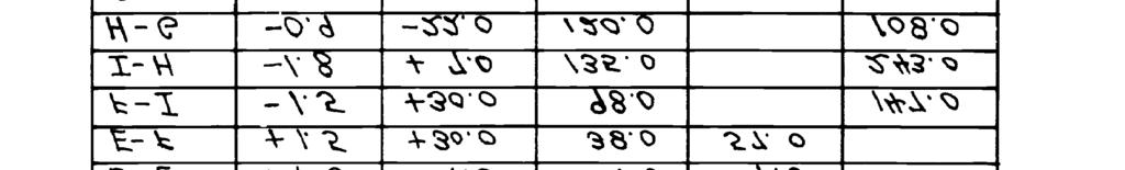
7 The stripper shown is 5 squares wide by 60 squares long. Its zero index is placed at the intersection of the ground and side-slope line of the section. The stripper is moved an interval of 5 squares to the right with zero reading at the bottom. It is then moved another 5 squares to the right with the previous top reading (2.5) now adjacent to the bottom line. The stripper is again moved 5 squares to the right for another interval with the previous top reading (6.0) adjacent to the bottom line. This process of moving 5 squares to the right and bringing the top reading to the bottom line is continued until the stripper reaches the right edge of the cross section with a final reading of Multiply this last reading (53.0) by the strip width used (5) to get the number of squares in the section (265.0). To find the area of the cross section in square feet, multiply the number of squares by the area in square feet of one square. Double-Meridian- Distance Method The double-meridian-distance (DMD) method gives a more precise value for a cross-section area than the stripper method. It does, however, involve more effort and time. It is essential that the elevations (latitudes) and the distance from the centerline (departures) of all points on the cross section be known. The method is based on the theory that the area of a right triangle equals one half of the product of the two sides. Since latitudes and departures are at right angles to each other, the area bounded by the distance, the latitude, and the departure is a right angle. The surveyor can determine this area by taking one half of the product of the latitude and the departure. However, depending on its location, the triangle may add to or subtract from the total area of the irregular figure. To avoid determining a plus or minus area for each triangle, a slight refinement is made. The departure is added twice. It is first added when determining the DMD of the course and second, when determining the next course s DMD. Multiplying the DMD of each course by its latitude results in twice the area, but the sign of this product illustrates whether the area adds to or subtracts from the figure area. A step-by-step procedure to work out a DMD area is given below and illustrated in figure 4-5. (1) (2) Select the far left station (D) as the first point and D-E as the first course to avoid negative areas in the DMD. (3) (4) (5) (6) (7) Compute and departures. record all the latitudes and The DMD of the first course equals the departure of the course itself, 4.0. The DMD of any other course (E-F) equals the DMD of the preceding course (D-E) plus the departure of the preceding course (D-E) and the departure of the course (E- F) itself or ,0 = For the next course (F-I), the same procedure is followed. Add together the DMD of the preceding course, the departure of the preceding course, and the departure of the course itself, or = The DMD of the last course is numerically equal to its departure but with the opposite sign (+14.0). Multiply each DMD value by its latitude. Positive products are entered under north double areas and negative products under south double areas. The sum of all north double areas minus the sum of all the south double areas, DISREGARDING THE SIGNS, equals twice the cross-section areas. Divide this double area by 2 to get the true crosssection area. 4-6

8 4-7
9 AREA BY PLANIMETER The surveyor uses a polar planimeter to measure the area of a plotted figure. There are two types of planimeters. One has a fixed scale, and one has an adjustable scale. Basically, the surveyor uses both in the same way, with the exception that the fixed scale cannot be adjusted to yield a 1:1 ratio when tracing areas. Operation The planimeter (figure 4-6) touches the paper at four points: the anchor point (B), the tracing point (A), the drum (C), and the support wheel (G). The adjustable tracing arm (E) is graduated to permit adjustment to the scale of the plotted figure. This adjustment provides a direct ratio between the area traced by the tracing point and the revolutions of the roller. The scale screws, Fl, F2, and F3, are used to accomplish the proper adjustment of the tracing arm scale. Proper scale settings are provided with each instrument. If the scale setting provided yields an area that is too large, the scale reading must be increased and vice versa. enables a single unit (ones) reading. The disk (D) is attached to the drum by a worm gear, counting the number of drum revolutions and giving the thousands reading. The surveyor must first read the disk for thousands, then the drum for hundreds and tens, and finally, the vernier for single units (ones). As the planimeter encircles the area to be measured, the drum (C) revolves and records the answer in tens and hundreds. A vernier (M) is mounted adjacent to the drum and 4-8
10 Procedures The following are rules for using a planimeter, Always measure cut and fill areas separately. Check the accuracy of the planimeter as a measuring device to guard against errors due to temperature changes and other noncompensating factors. A simple method of testing its consistency of operation is to trace an area of 1 square inch with the arm set for a 1:1 ratio. The disk, drum, and vernier combined should read for this area. Before measuring a specific area, determine the scale of the plot and set the adjustable arm of the planimeter according to the chart in the planimeter case. Check the setting by carefully tracing a known area, such as five large squares on the cross-section paper, and verifying the reading on the disk, drum, and vernier. If the reading is inconsistent with the known area, readjust the arm settings until a satisfactory reading is obtained. To measure an area, set the anchor point of the adjusted planimeter at a convenient position outside the plotted area; place the tracing point on a selected point on the perimeter of the cross section; take an initial reading from the disk, drum, and vernier; continue tracing the perimeter clockwise, keeping the tracing point carefully on the line being followed; and when the tracing point closes on the initial point, again take a reading from the disk, drum, and vernier. The difference between the initial reading and the final reading gives a value proportional to the area being traced. Make two independent measurements of the area to insure accurate results. Make the second measurement with the tracing point placed at a point on the opposite side of the first measurement. This procedure gives two compensating readings. The mean of these readings is more accurate than either one individually. To measure plotted areas larger than the capacity of the planimeter, divide the areas into sections and measure each separately. Section III. EARTH AND ROCK EXCAVATION CLASSES OF EXCAVATED MATERIAL Excavated material is usually classified as common excavation, loose rock, and solid rock. Although classifying excavation material is not a survey function, the surveyor must differentiate among the different types so excavation records will match the construction work. When performing surveys to determine quantities of excavated materials, the surveyor must record common excavation, loose-rock excavation, and solidrock excavation data separately in the field notes. Common excavation involves the moving of earth or of earth with detached boulders less than one-half cubic yard in volume. Looserock excavation involves the moving of consolidated materials which have been loosened without blasting with picks, bars, or simple air and mechanical devices. Solidrock excavation involves the moving of rock from solid beds or the breaking up of boulders measuring 1 cubic yard or more by means of explosives. 4-9
11 BORROW PITS When there is an imbalance in the volume of cuts and fills in construction projects, it is often necessary to borrow the required fill dirt from borrow pits outside the construction limits but near the fill site. Any time the haul distance between the last available dirt and the fill site becomes too far, it is cheaper to establish a borrow pit. Under some circumstances, it is not necessary to survey borrow pits. However, it is often necessary to buy the fill dirt. The surveyor must determine how much earth was removed from the borrow pit. This can be done by establishing a grid over the area to be excavated. The grid can beat any convenient interval (for example, 10-, 25-, 50-, or 100-foot squares). Once the grid is staked, the surveyor can determine the elevation of each grid corner by leveling. The volume of earth that has been removed can be computed at any time by reestablishing the grid corners and determining their new elevation. The surveyor does this by subtracting the average elevation of the grid corners after excavation from the average elevation of the same grid corners before excavation and multiplying the difference by the number of square feet in the grid square. When laying out the grid, the surveyor must lay out two baselines parallel to two adjacent sides of the grid for use in reestablishing the grid. The surveyor should place them far enough outside the area of excavation to avoid destruction but close enough to be convenient. (See figure 4-7.) The surveyor should treat waste areas or dumps where excess material is deposited in the same manner as borrow pits, with the exception that the volume to be measured is the volume deposited, not excavated. 4-10
12 4-11
QUANTITY SURVEYS. Introduction
 QUANTITY SURVEYS Introduction In engineering surveying, we often consider a route (road, sewer pipeline, channel, etc.) from three distinct perspectives. The plan view of route location is the same as
Legal Description & Site Plan Requirements and Layouts
 Legal Description & Site Plan Requirements and Layouts Plot Plan * A plot plan shows the location of a house from an aerial view. * The site plan, also known as a plot or lot plan includes: 1. Site plan
We will study all three methods, but first let's review a few basic points about units of measurement.
 WELCOME Many pay items are computed on the basis of area measurements, items such as base, surfacing, sidewalks, ditch pavement, slope pavement, and Performance turf. This chapter will describe methods
Question bank. Unit 1: Introduction
 Question bank Unit 1: Introduction 1. Define surveying. 2. State the objects of surveying 3. State and explain the principle of surveying 4. State and explain the classification of surveying 5. Differentiate
Math Review Questions
 Math Review Questions Working with Feet and Inches A foot is broken up into twelve equal parts called inches. On a tape measure, each inch is divided into sixteenths. To add or subtract, arrange the feet
Chapter 3: Assorted notions: navigational plots, and the measurement of areas and non-linear distances
 : navigational plots, and the measurement of areas and non-linear distances Introduction Before we leave the basic elements of maps to explore other topics it will be useful to consider briefly two further
Lesson 8: Surveying the Forest
 Lesson 8: Surveying the Forest TEACHER: SCHOOL: GRADE LEVEL: 9-12 TASKS/COMPETENCIES ANR8046.172 Set up and operate a transit level and rod. ANR8046.173 Read a rod and a level to calculate slope. ANR8046.174
This Land Surveying course has been developed by. Failure & Damage Analysis, Inc.
 This Land Surveying course has been developed by Failure & Damage Analysis, Inc. www.discountpdh.com www.pepdh.com Bridge Surveying SURVEYS Bridge surveying is necessary to locate a site, obtain information
Surveying & Measurement. Detail Survey Topographic Surveying
 Surveying & Measurement Detail Survey Topographic Surveying Introduction Mapping surveys are made to determine the relief of the earth s surface and locate critical points on it. to determine the locations
appendix f: slope density
 CONTENTS: F-2 Statement of Purpose F-3 Discussion of Slope F-4 Description of Slope Density The Foothill Modified Slope Density The Foothill Modified 1/2 Acre slope density The 5 20 slope density F-7 How
Shoe Box Activity Constructing a Topographic Map
 Shoe Box Activity Constructing a Topographic Map Background Information All maps are models of some feature of the real world. The kind of map oen used by scientists is called a contour or topographic
4 th Grade Curriculum Map
 4 th Grade Curriculum Map 2017-18 MONTH UNIT/ CONTENT CORE GOALS/SKILLS STANDARDS WRITTEN ASSESSMENTS ROUTINES RESOURCES VOCABULARY September Chapter 1 8 days NUMBERS AND OPERATIONS IN BASE TEN WORKING
Geometry. Practice Pack
 Geometry Practice Pack WALCH PUBLISHING Table of Contents Unit 1: Lines and Angles Practice 1.1 What Is Geometry?........................ 1 Practice 1.2 What Is Geometry?........................ 2 Practice
SECTION 3. Housing. FAppendix F SLOPE DENSITY
 SECTION 3 Housing FAppendix F SLOPE DENSITY C-2 Housing Commission Attachment B Appendix F Slope Density STATEMENT OF PURPOSE This appendix has been prepared with the intent of acquainting the general
Unit 6, Activity 1, Measuring Scavenger Hunt
 Unit 6, Activity 1, Measuring Scavenger Hunt Name: Measurement Descriptions Object 1. 2. 3. 4. 5. 6. 7. 8. 9. 10. Blackline Masters, Mathematics, Grade 7 Page 6-1 Unit 6, Activity 4, Break it Down Name
Leveling. Double-Rodded Leveling. Illustrative Problem. Double-Rodded Leveling 8/17/2014
 Double-Rodded Leveling Double-Rodded Leveling A method of determining the differences in elevation between points by employing two level routes simultaneously Two turning points are established such that
Copyrighted Material. Copyrighted Material. Copyrighted. Copyrighted. Material
 Engineering Graphics ORTHOGRAPHIC PROJECTION People who work with drawings develop the ability to look at lines on paper or on a computer screen and "see" the shapes of the objects the lines represent.
Lesson 5: Area of Composite Shape Subject: Math Unit: Area Time needed: 60 minutes Grade: 6 th Date: 2 nd
 Lesson 5: Area of Composite Shape Subject: Math Unit: Area Time needed: 60 minutes Grade: 6 th Date: 2 nd Materials, Texts Needed, or advanced preparation: Lap tops or computer with Geogebra if possible
1 Exam Prep Prov Module: Distance Measurement and Leveling Questions and Answers
 1 Exam Prep Prov Module: 28306-05 Distance Measurement and Leveling Questions and Answers 1. Site layout involves extensive use of plans. A. Foundation B. Elevation C. Floor D. Plot 2. Contour lines are
Intermediate Mathematics League of Eastern Massachusetts
 Intermediate Mathematics League of Eastern Massachusetts Meet # 2 December 2000 Category 1 Mystery 1. John has just purchased five 12-foot planks from which he will cut a total of twenty 3-inch boards
Honors Geometry Summer Math Packet
 Honors Geometry Summer Math Packet Dear students, The problems in this packet will give you a chance to practice geometry-related skills from Grades 6 and 7. Do your best to complete each problem so that
Locating the House on the Building Site
 9 Locating the House on the Building Site Section 9.1 Basic Site Layout Section 9.2 Establishing Lines & Grades Chapter Objectives After completing this chapter, you will be able to: Create a simple building
The Grade 6 Common Core State Standards for Geometry specify that students should
 The focus for students in geometry at this level is reasoning about area, surface area, and volume. Students also learn to work with visual tools for representing shapes, such as graphs in the coordinate
COURSE SYLLABUS SURVEYING I
 Solution Manual for Surveying Fundamentals and Practices 6th Edition by Nathanson Lanzafama Emeritus Link full download: http://testbankcollection.com/download/solution-manual-forsurveying-fundamentals-and-practices-6th-edition-by-nathanson-lanzafamaemeritus/
Squares Multiplication Facts: Square Numbers
 LESSON 61 page 328 Squares Multiplication Facts: Square Numbers Name Teacher Notes: Introduce Hint #21 Multiplication/ Division Fact Families. Review Multiplication Table on page 5 and Quadrilaterals on
4 th Grade Mathematics Learning Targets By Unit
 INSTRUCTIONAL UNIT UNIT 1: WORKING WITH WHOLE NUMBERS UNIT 2: ESTIMATION AND NUMBER THEORY PSSA ELIGIBLE CONTENT M04.A-T.1.1.1 Demonstrate an understanding that in a multi-digit whole number (through 1,000,000),
1 st Subject: 2D Geometric Shape Construction and Division
 Joint Beginning and Intermediate Engineering Graphics 2 nd Week 1st Meeting Lecture Notes Instructor: Edward N. Locke Topic: Geometric Construction 1 st Subject: 2D Geometric Shape Construction and Division
Park Forest Math Team. Meet #2. Geometry. Self-study Packet
 Park Forest Math Team Meet #2 Self-study Packet Problem Categories for this Meet: 1. Mystery: Problem solving 2. : ngle measures in plane figures including supplements and complements 3. Number Theory:
NSCAS - Math Table of Specifications
 NSCAS - Math Table of Specifications MA 3. MA 3.. NUMBER: Students will communicate number sense concepts using multiple representations to reason, solve problems, and make connections within mathematics
3.3. You wouldn t think that grasshoppers could be dangerous. But they can damage
 Grasshoppers Everywhere! Area and Perimeter of Parallelograms on the Coordinate Plane. LEARNING GOALS In this lesson, you will: Determine the perimeter of parallelograms on a coordinate plane. Determine
Vocabulary slope, parallel, perpendicular, reciprocal, negative reciprocal, horizontal, vertical, rise, run (earlier grades)
") Slope Reporting Category Reasoning, Lines, and Transformations Topic Exploring slope, including slopes of parallel and perpendicular lines Primary SOL G.3 The student will use pictorial representations,
Slope Reporting Category Reasoning, Lines, and Transformations Topic Exploring slope, including slopes of parallel and perpendicular lines Primary SOL G.3 The student will use pictorial representations,
What You ll Learn. Why It s Important. You see geometric figures all around you.
 You see geometric figures all around you. Look at these pictures. Identify a figure. What would you need to know to find the area of that figure? What would you need to know to find the perimeter of the
Suveying Lectures for CE 498
 Suveying Lectures for CE 498 SURVEYING CLASSIFICATIONS Surveying work can be classified as follows: 1- Preliminary Surveying In this surveying the detailed data are collected by determining its locations
Section E NSPS MODEL STANDARDS FOR TOPOGRAPHIC SURVEYS Approved 3/12/02
 Section E NSPS MODEL STANDARDS FOR TOPOGRAPHIC SURVEYS Approved 3/12/02 1. INTRODUCTION This standard is written to provide the professional surveyor (Surveyor) and the client with a guideline for producing
Introduction to Surveying. Chapter -One-
 Introduction to Surveying Chapter -One- 1 GENERAL INFORMATION FALL 2016 Assistant Lecturer : Asmaa Abdulmajeed Research Assistant: Zanyar Bazyan Course Title : Surveying 1 Course Code : CE 215 Class No
Geometry Topic 4 Quadrilaterals and Coordinate Proof
 Geometry Topic 4 Quadrilaterals and Coordinate Proof MAFS.912.G-CO.3.11 In the diagram below, parallelogram has diagonals and that intersect at point. Which expression is NOT always true? A. B. C. D. C
Figure Sample field notes from cross-section leveling at first three stations shown in figure NAVEDTRA 14069A 15-26
 method so that a point 100 feet away is within 1 foot of the true perpendicular. Measure elevations consisting of abrupt changes or breaks in the ground with a rod and level. Use a metallic tape to measure
UNIT 10 PERIMETER AND AREA
 UNIT 10 PERIMETER AND AREA INTRODUCTION In this Unit, we will define basic geometric shapes and use definitions to categorize geometric figures. Then we will use the ideas of measuring length and area
Fair Game Review. Chapter 4. Name Date. Find the area of the square or rectangle Find the area of the patio.
 Name Date Chapter Fair Game Review Find the area of the square or rectangle... ft cm 0 ft cm.. in. d in. d. Find the area of the patio. ft 0 ft Copright Big Ideas Learning, LLC Big Ideas Math Green Name
Chapter 3 Linear Equations in Two Variables
 Chapter Linear Equations in Two Variables. Check Points. 6. x y x ( x, y) y ( ) 6, 6 y ( ), 0 y (0) 0, y () 0,0 y (),. E(, ) F(,0) G (6,0). a. xy 9 ( ) 9 69 9 9, true (, ) is a solution. b. xy 9 () 9 99
CHECKLIST PRELIMINARY SUBDIVISION AND PRELIMINARY SITE PLAN
 N/A Waiver (1) Four (4) copies of application form. (2) Fifteen (15) copies of plan (3) Subdivision/site plan application fee & professional review escrow deposit (4) Variance application fee & professional
CHAPTER 3 MARGINAL INFORMATION AND SYMBOLS
 CHAPTER 3 MARGINAL INFORMATION AND SYMBOLS A map could be compared to any piece of equipment, in that before it is placed into operation the user must read the instructions. It is important that you, as
B 2 3 = 4 B 2 = 7 B = 14
 Bridget bought a bag of apples at the grocery store. She gave half of the apples to Ann. Then she gave Cassie 3 apples, keeping 4 apples for herself. How many apples did Bridget buy? (A) 3 (B) 4 (C) 7
Measurement and Data Core Guide Grade 4
 Solve problems involving measurement and conversion of measurements from a larger unit to a smaller unit (Standards 4.MD.1 2) Standard 4.MD.1 Know relative sizes of measurement units within each system
How to Graph Trigonometric Functions
 How to Graph Trigonometric Functions This handout includes instructions for graphing processes of basic, amplitude shifts, horizontal shifts, and vertical shifts of trigonometric functions. The Unit Circle
Excavation and embankment (cut and fill)
") Excavation and embankment (cut and fill) Excavation = the removal of soil or rock from its natural location. Embankment = the placement and compaction of layers of earth or rock to form a roadbed of the
Excavation and embankment (cut and fill) Excavation = the removal of soil or rock from its natural location. Embankment = the placement and compaction of layers of earth or rock to form a roadbed of the
Location of Structure on Site
 Chapter 1 Location of Structure on Site A number of factors affect the location of a structure on a site, as well as the type of building that may be erected. Once the site is chosen, different methods
Pennsylvania System of School Assessment
 Mathematics, Grade 04 Pennsylvania System of School Assessment The Assessment Anchors, as defined by the Eligible Content, are organized into cohesive blueprints, each structured with a common labeling
10/9/2018. Introduction to Surveying. Chapter -One-
 Introduction to Surveying Chapter -One- 1 GENERAL INFORMATION FALL 2018-2019 Assistant Lecturer : Asmaa Ab. Mustafa Research Assistant: Course Title : Surveying Course Code : ARCH 224 Class No : S. 203
Objective: Use the addition of adjacent angle measures to solve problems using a symbol for the unknown angle measure.
 Lesson 10 Objective: Use the addition of adjacent angle measures to solve problems using a Suggested Lesson Structure Fluency Practice Application Problem Concept Development Student Debrief Total Time
+ 4 ~ You divided 24 by 6 which equals x = 41. 5th Grade Math Notes. **Hint: Zero can NEVER be a denominator.**
 Basic Fraction numerator - (the # of pieces shaded or unshaded) denominator - (the total number of pieces) 5th Grade Math Notes Mixed Numbers and Improper Fractions When converting a mixed number into
MEA 501 LESSON _NOTES Period. CRS SKILL LEVEL DESCRIPTION Level 1 ALL students must MEA 301 Compute the perimeter of polygons when all
 MEA 501 LESSON _NOTES Period Name CRS SKILL LEVEL DESCRIPTION Level 1 ALL students must MEA 301 Compute the perimeter of polygons when all attain mastery at this level side lengths are given MEA 302 Compute
Math + 4 (Red) SEMESTER 1. { Pg. 1 } Unit 1: Whole Number Sense. Unit 2: Whole Number Operations. Unit 3: Applications of Operations
 SEMESTER 1. { Pg. 1 } Unit 1: Whole Number Sense. Unit 2: Whole Number Operations. Unit 3: Applications of Operations") Math + 4 (Red) This research-based course focuses on computational fluency, conceptual understanding, and problem-solving. The engaging course features new graphics, learning tools, and games; adaptive
Math + 4 (Red) This research-based course focuses on computational fluency, conceptual understanding, and problem-solving. The engaging course features new graphics, learning tools, and games; adaptive
Lesson 1 Area of Parallelograms
 NAME DATE PERIOD Lesson 1 Area of Parallelograms Words Formula The area A of a parallelogram is the product of any b and its h. Model Step 1: Write the Step 2: Replace letters with information from picture
Northern York County School District Curriculum
 Northern York County School District Curriculum Course Name Grade Level Mathematics Fourth grade Unit 1 Number and Operations Base Ten Time Frame 4-5 Weeks PA Common Core Standard (Descriptor) (Grades
PHOTOGRAMMETRY STEREOSCOPY FLIGHT PLANNING PHOTOGRAMMETRIC DEFINITIONS GROUND CONTROL INTRODUCTION
 PHOTOGRAMMETRY STEREOSCOPY FLIGHT PLANNING PHOTOGRAMMETRIC DEFINITIONS GROUND CONTROL INTRODUCTION Before aerial photography and photogrammetry became a reliable mapping tool, planimetric and topographic
h r c On the ACT, remember that diagrams are usually drawn to scale, so you can always eyeball to determine measurements if you get stuck.
 ACT Plane Geometry Review Let s first take a look at the common formulas you need for the ACT. Then we ll review the rules for the tested shapes. There are also some practice problems at the end of this
Figure 8-1 Layout equipment and tools. Tape measure. String line level. Eyepiece level. Laser plane level Delmar/Cengage Learning.
 3 2 1 0 Tape measure String line level Clinometer Eyepiece level Transit Dumpy level Carpenter s or builder s level Electronic measurement Tool Laser plane level Figure 8-1 Layout equipment and tools.
Subdivision Application Checklist
 City of Portsmouth, New Hampshire Subdivision Application Checklist This subdivision application checklist is a tool designed to assist the applicant in the planning process and for preparing the application
STATE UNIVERSITY CONSTRUCTION FUND
 DIRECTIVE 1C-12 Issue date: August 2012 1. General SURVEY, MAPPING AND UTILITY LOCATING This Directive has been developed as a general guide for the survey and mapping effort required for Fund projects.
8/17/2014. Process of directly or indirectly measuring vertical distances to determine the elevation of points or their differences in elevation
 Process of directly or indirectly measuring vertical distances to determine the elevation of points or their differences in elevation Leveling results are used: To design highways, railroads, canals, sewers,
Construction Surveying and Layout
 Construction Surveying and Layout A Field Engineering Methods Manual Third Edition WESLEY G. CRAWFORD.CREATIVE CONSTRUCTION Creative Construction Publishing, Inc. 2720 South River Road West Lafayette,
Section 2.3 Task List
 Summer 2017 Math 108 Section 2.3 67 Section 2.3 Task List Work through each of the following tasks, carefully filling in the following pages in your notebook. Section 2.3 Function Notation and Applications
Mapping The Study Area
 While on the beach you will need to take some measurements to show where the study area is relative to the rest of the world and to show what is inside the study area. Once the measurements have been taken,
Slope Floor. Measurement Methods
 Slope Floor Measurement Methods Many chair installations are on sloped floors. Hussey Seating uses five different feet for floor mount chairs based on the degree of slope. The slope of the floor is a critical
SESSION THREE AREA MEASUREMENT AND FORMULAS
 SESSION THREE AREA MEASUREMENT AND FORMULAS Outcomes Understand the concept of area of a figure Be able to find the area of a rectangle and understand the formula base times height Be able to find the
Geometer s Skethchpad 8th Grade Guide to Learning Geometry
 Geometer s Skethchpad 8th Grade Guide to Learning Geometry This Guide Belongs to: Date: Table of Contents Using Sketchpad - - - - - - - - - - - - - - - - - - - - - - - - - - - - - - - - - - - - - - - -
INTERMEDIATE LEVEL MEASUREMENT
 INTERMEDIATE LEVEL MEASUREMENT TABLE OF CONTENTS Format & Background Information...3-6 Learning Experience 1- Getting Started...6-7 Learning Experience 2 - Cube and Rectangular Prisms...8 Learning Experience
Title: How steep are those hills? Engineering Grade: Estimated Time: 3 hours (2 days) Groups: 3 to 4 students
 Groups: 3 to 4 students") Title: How steep are those hills? Engineering Grade: 10-12 Estimated Time: 3 hours (2 days) Groups: 3 to 4 students Synopsis: Students will be able to understand the concept of surveying and mapping ground
Title: How steep are those hills? Engineering Grade: 10-12 Estimated Time: 3 hours (2 days) Groups: 3 to 4 students Synopsis: Students will be able to understand the concept of surveying and mapping ground
Math 2 nd Grade GRADE LEVEL STANDARDS/DOK INDICATORS
 Number Properties and Operations Whole number sense and addition and subtraction are key concepts and skills developed in early childhood. Students build on their number sense and counting sense to develop
Georgia Department of Education
 Fourth Grade 4.NOP.1 Multiplication and division; Find the factor pairs for a given whole number less than or equal to 100; recognize prime numbers as numbers greater than 1 with exactly one factor pair.
LIST OF HANDS-ON ACTIVITIES IN MATHEMATICS FOR CLASSES III TO VIII. Mathematics Laboratory
 LIST OF HANDS-ON ACTIVITIES IN MATHEMATICS FOR CLASSES III TO VIII Mathematics Laboratory The concept of Mathematics Laboratory has been introduced by the Board in its affiliated schools with the objective
Applications and Setups
 1 Applications and Setups Manhole stake This section describes three fundamentals for using the Model DG813/613 to install gravity flow pipe; they are Grade, Elevation, and Line otherwise known as G-E-L.
The several methods for making linear measurements are quite simple and straightforward. They are described below:
 INTRODUCTION TO LINEAR MEASUREMENTS Many pay items are measured on the basis of linear measurements - items such as guardrail, pipe culvert, curb and gutter, fencing, etc. These measurements usually are
Mathematics Geometry Grade 6AB
 Mathematics Geometry Grade 6AB It s the Right Thing Subject: Mathematics: Geometry: Ratio and Proportion Level: Grade 7 Abstract: Students will learn the six types of triangles and the characteristics
Angle Measure and Plane Figures
 Grade 4 Module 4 Angle Measure and Plane Figures OVERVIEW This module introduces points, lines, line segments, rays, and angles, as well as the relationships between them. Students construct, recognize,
1. Convert 60 mi per hour into km per sec. 2. Convert 3000 square inches into square yards.
 ACT Practice Name Geo Unit 3 Review Hour Date Topics: Unit Conversions Length and Area Compound shapes Removing Area Area and Perimeter with radicals Isosceles and Equilateral triangles Pythagorean Theorem
Summer Solutions Common Core Mathematics 4. Common Core. Mathematics. Help Pages
 4 Common Core Mathematics 63 Vocabulary Acute angle an angle measuring less than 90 Area the amount of space within a polygon; area is always measured in square units (feet 2, meters 2, ) Congruent figures
Geometer s Skethchpad 7th Grade Guide to Learning Geometry
 Geometer s Skethchpad 7th Grade Guide to Learning Geometry This Guide Belongs to: Date: 2 -- Learning with Geometer s Sketchpad **a story can be added or one could choose to use the activities alone and
50.24 Type, Size and Location Plans for Culverts, Bridges and Culvert Bridges
 50.24 Culverts, Bridges and Culvert Bridges Type, Size and Location (T, S & L) Plans shall be required for all Bridges, Culvert Bridges and Culverts of eight-foot (8') clear span or greater as follows:
MATH MEASUREMENT AND GEOMETRY
 Students: 1. Students choose appropriate units of measure and use ratios to convert within and between measurement systems to solve problems. 1. Compare weights, capacities, geometric measures, time, and
Area of Composite Figures. ESSENTIAL QUESTION How do you find the area of composite figures? 7.G.2.6
 LESSON 9.3 Area of Composite Figures Solve real-world and mathematical problems involving area, of objects composed of triangles, quadrilaterals, polygons,. ESSENTIAL QUESTION How do you find the area
Activity overview. Background. Concepts. Random Rectangles
 by: Bjørn Felsager Grade level: secondary (Years 9-12) Subject: mathematics Time required: 90 minutes Activity overview What variables characterize a rectangle? What kind of relationships exists between
Mrs. Ambre s Math Notebook
 Mrs. Ambre s Math Notebook Almost everything you need to know for 7 th grade math Plus a little about 6 th grade math And a little about 8 th grade math 1 Table of Contents by Outcome Outcome Topic Page
1 six 2 sixes 3 sixes 4 sixes 5 sixes 6 sixes 7 sixes 8 sixes 9 sixes 10 sixes
 Lesson 5 3 6 Lesson 5 Objective: Create ruler with 1-inch, 1 -inch, and 1 -inch intervals, and 2 generate Suggested Lesson Structure Fluency Practice Concept Development Student Debrief Total Time (10
What Is Leaps and Bounds? A Research Foundation How to Use Leaps and Bounds Frequently Asked Questions Components
 Contents Program Overview What Is Leaps and Bounds? A Research Foundation How to Use Leaps and Bounds Frequently Asked Questions Components ix x xiv xvii xix Teaching Notes Strand: Number Number Strand
Grade 4 Mathematics Indiana Academic Standards Crosswalk
 Grade 4 Mathematics Indiana Academic Standards Crosswalk 2014 2015 The Process Standards demonstrate the ways in which students should develop conceptual understanding of mathematical content and the ways
determining the relative height of different
 Levelling & Contouring Principle of levelling Principle:-The principle of levelling is to obtain horizontal line of sight with respect to which vertical distances of the points above or below this line
Important Questions. Surveying Unit-II. Surveying & Leveling. Syllabus
 Surveying Unit-II Important Questions Define Surveying and Leveling Differentiate between Surveying and Leveling. Explain fundamental Principles of Surveying. Explain Plain and Diagonal Scale. What is
6.00 Trigonometry Geometry/Circles Basics for the ACT. Name Period Date
 6.00 Trigonometry Geometry/Circles Basics for the ACT Name Period Date Perimeter and Area of Triangles and Rectangles The perimeter is the continuous line forming the boundary of a closed geometric figure.
Owner's Manual & Assembly Instructions
 Owner's Manual & Assembly Instructions PK01 BASE KIT Model No. FDN106 71706011 CAUTION: SOME PARTS HAVE SHARP EDGES. CARE MUST BE TAKEN WHEN HANDLING THE VARIOUS PIECES TO AVOID A MISHAP. FOR SAFETY SAKE,
SECTION SITE SURVEYS
 SECTION 02 21 13 SITE SURVEYS SPEC WRITER NOTE: 1. Delete text between // // not applicable to project. Edit remaining text to suit project. 2. Use this section to specify survey required before design
Grade 8, Unit 3 Practice Problems - Open Up Resources
 Grade 8, - Open Up Resources Lesson 1 Priya jogs at a constant speed. The relationship between her distance and time is shown on the graph. Diego bikes at a constant speed twice as fast as Priya. Sketch
Drawing Daisy Wheel Angles and Triangles
 Drawing Daisy Wheel Angles and Triangles Laurie Smith Laurie Smith is an independent early-building design researcher, specialising in geometrical design systems. Because geometry was part of the medieval
Common Core State Standard I Can Statements 2 nd Grade
 CCSS Key: Operations and Algebraic Thinking (OA) Number and Operations in Base Ten (NBT) Measurement and Data (MD) Geometry (G) Common Core State Standard 2 nd Grade Common Core State Standards for Mathematics
Find the value of the expressions. 3 x = 3 x = = ( ) 9 = 60 (12 + 8) 9 = = 3 9 = 27
 9 = 60 (12 + 8) 9 = = 3 9 = 27") PreAlgebra Concepts Important Concepts exponent In a power, the number of times a base number is used as a factor order of operations The rules which tell which operation to perform first when more than
PreAlgebra Concepts Important Concepts exponent In a power, the number of times a base number is used as a factor order of operations The rules which tell which operation to perform first when more than
Contour An imaginary line on the ground surface joining the points of equal elevation is known as contour.
 Contour An imaginary line on the ground surface joining the points of equal elevation is known as contour. In other words, contour is a line in which the ground surface is intersected by a level surface
2.NBT.1 20) , 200, 300, 400, 500, 600, 700, 800, NBT.2
 , 200, 300, 400, 500, 600, 700, 800, NBT.2") Saxon Math 2 Class Description: Saxon mathematics is based on the principle of developing math skills incrementally and reviewing past skills daily. It also incorporates regular and cumulative assessments.
Saxon Math 2 Class Description: Saxon mathematics is based on the principle of developing math skills incrementally and reviewing past skills daily. It also incorporates regular and cumulative assessments.
THE SIX SIMPLE MACHINES
 Simple Machines A machine is a device that helps make work easier to perform. (Remember, Work = Force X Distance). A machine makes work easier to perform by accomplishing one or more of the following functions:
Selected Answers for Core Connections, Course 2
 Selected Answers for Core Connections, Course 2 Lesson 6.1.1 6-6. x x + 1 3 = 2 b: 2x 2 + 4x x + 2 3 = 2x 2 + 3x 1 6-7. Parts a, c, and d match the perimeter. 6-8. a: 23 20 or 1 3 20 d: 19 15 or 1 4 15