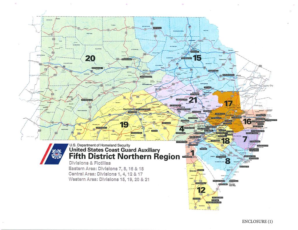
Sector Delaware Bay/District 5NR - Coast Guard Auxiliary Patrol Areas. Eastern Area
|
|
|
- Paula Hart
- 5 years ago
- Views:
Transcription
1
2 Enclosure (2) to SECDELBAYINST F Sector Delaware Bay/District 5NR - Coast Guard Auxiliary Patrol Areas STA Manasquan Inlet: (Div 16) Eastern Area Station (Small) Shark River: AREA 1 Shark River and offshore (Long Branch to Spring Lake) and all navigable waterways. Station Manasqaun Inlet: AREA 2 Manasquan River and offshore (Spring Lake to Seaside Pier) and all navigable waterways. AREA 3 Northern entrance of the Point Pleasant Canal to ICW marker # 19 and all navigable waters including the Beaverdam Creek and the Metedeconk River. AREA 4 Back Bay from ICW marker # 19 South to the Seaside/Thomas Mathis Bridge all navigable waters including Kettle Creek and Silver Bay Areas. STA Barnegat Light: (Div 7) AREA 1- (Northern) - RT 37 Bridge Seaside/Thomas Mathis Bridge to NJICW Light #42, including Barnegat Inlet (Oyster Creek and Double Creek Channels) Barnegat Bay and offshore. AREA 2 - (Central North) NJICW Light #40 to RT 72 Bridge, including Barnegat Inlet (Oyster Creek Channel, Double Creek Channel) Barnegat Bay and offshore. Station (Small) Beach Haven: AREA 3- (Central South) - RT 72 Bridge to Little Egg Inlet, including Little Egg Harbor, Little Egg/Beach Haven Inlets and offshore. AREA 4 - (Southern) NJICW Light #104 to NJICW Light #139, including Great Bay, Mullica River and Bass River to the G.S. Pkwy Bridges, Little Egg/Beach Haven Inlet and offshore. STA Atlantic City: (Div 8) AREA 1 - NJICW North - NJICW #181 to NJICW #139, to include Absecon Inlet, Mullica River, Bass River, Great Bay and Absecon Bay. AREA 2- NJICW Middle - NJICW #182 to NJICW #233, to include Longport Channel and Lakes Bay 1
3 Enclosure (2) to SECDELBAYINST F Eastern Area (continued) Station (Small) Great Egg: AREA 3- NJICW South - NJICW #234 to NJICW #309, to include Great Egg Inlet, Great Egg Harbor River, Great Egg Harbor Bay and Ships Channel. AREA 4 - Offshore - Little Egg Inlet to Corson Inlet STA Cape May: (Div 8) AREA 1- (Cape May) Flotilla 8-2 Covers Cape May Harbor, inlet, canal, and offshore up to 3 nm, the ICW north to Stone Harbor, and Delaware Bay up to Brandywine Light out to the Main Shipping Channel. Station (Small) Townsend Inlet: AREA 2- (Wildwood) -Flotilla 8-3 Covers from Herford Inlet to Cape May, offshore, ICW, and Delaware Bay north to 14 Foot Bank Light out to the Main Shipping Channel. AREA 3- (Lower Township) -Flotilla 8-6 Covers ICW from Herford Inlet up to Great Egg Inlet with coverage of Delaware Bay including Private Aid Position reporting. Station (Small) Fortesque: AREA 4 - (Maurice River) - Flotilla 8-8 Covers Maurice River and Northern Delaware Bay. STA Indian River Inlet: (Div 12) Central Area SARDET Bowers Beach: AREA 1A North - Delaware Bay from Ship John Shoal to Brown Shoal Light out to the Main Shipping Channel Station (Small) Roosevelt Inlet: AREA 1B South - Delaware Bay from Ship John Shoal to Cape Henlopen out to the Main Shipping Channel including Harbor of Refuge and Lewes Harbor. AREA 2- (Southern) Rehoboth Bay / Indian River Bay, including Indian River Inlet and up to 3 miles offshore between Cape Henlopen and Fenwick Island to the 5NR and 5SR border. AREA 3 - (Delaware Inland) Nanticoke Creek, Seaford to D5-SR Border (DE/MD line) 2
4 STA Philadelphia (Delaware River) Enclosure (2) to SECDELBAYINST F Central Area (continued) Station (Small) Salem AREA 9 Ship John Shoal to C & D Canal DIVISION 1 C & D Canal to Delaware/Maryland State Line SARDET Marcus Hook AREA 9 Ship John Shoal to C & D Canal DIVISION 1 AREA 10 C & D Canal to DE/PA State Line at Marcus Hook DIVISION 1 AREA 11 DE/PA State Line to Schuylkill River DIVISION 4 AREA 12 Schuylkill River to Betsy Ross Bridge DIVISION 4 and 18 AREA 13 Betsy Ross Bridge to Mudd Island DIVISION 18 SARDET Bordentown AREA 14 Mudd Island to Trenton DIVISION 17 Western Area Sector Delaware Bay: (OPCOM for all Western Patrol Areas) AREA 15A Raystown Lake North DIVISION 20 AREA 15B Raystown Lake South DIVISION 20 AUXSTA Long Level AREA 16 Lake Clarke DIVISION 19 AREA 17 Lake Nockamixon DIVISION 21 AREA 18 Lake Beltsville DIVISION 15 AREA 19 Blue Marsh Lake DIVISION 21 AREA 20 Lake Glendale DIVISION 20 AREA 21A Lake Wallenpaupak East DIVISION 15 AREA 21B Lake Wallenpaupak West DIVISION 15 AREA 22 Harvey s Lake DIVISION 15 3
5 Enclosure (2) to SECDELBAYINST F Western Area (continued) AREA 23 Williamsport Pool Susquehanna River DIVISION 20 AUXSTA Long Level AREA 24 Lake Aldred Susquehanna River DIVISION 19 AREA 25 (No longer Exists) AREA 26 Lake Frederick Susquehanna River DIVISION 19 AREA 27 Harrisburg Pool Susquehanna River DIVISION 19 AREA 28 Shikellemy Pool Susquehanna River DIVISION 20 AREA 29 Tioga/Hammond Lake DIVISION 20 AREA 30 Lake Marburg DIVISION 19 AREA 31 Cowansque Lake DIVISION 20 AREA 32 Sayers Lake DIVISION 20 AREA 33 East Branch Lake DIVISION 20 AREA 34 Susquehanna River Towanda DIVISION 15 AREA 35 Susquehanna River Jersey Shore, PA DIVISION 20 AREA 36 Allegheny River Kinzua Lake DIVISION 20 AREA 37A Lake Hopatcong North DIVISION 15 AREA 37B Lake Hopatcong South DIVISION 15 4
6
7
8

9
Dredging, Beach Nourishment and. Bird Conservation Workshop Atlantic Coast Region
 Dredging, Beach Nourishment and US Army Corps Bird Conservation Workshop Atlantic Coast Region Beach Nourishment and Bird Habitat Restoration in Southern New Jersey Shore Protection and Ecosystem Restoration
New Jersey Dept. of Environmental Protection Shore Protection Program
 New Jersey Dept. of Environmental Protection William Dixon, Acting Manager 1510 Hooper Avenue, Suite 140 Toms River, New Jersey 08753 1-732-255-0767 New Jersey s State of New Jersey Chris Christie, Governor
TABLE OF CONTENTS. Executive Summary 1 Acknowledgements 3 Introduction 3 Storm Recovery and Beach Project Effectiveness 3
 TABLE OF CONTENTS Executive Summary 1 Acknowledgements 3 Introduction 3 Storm Recovery and Beach Project Effectiveness 3 Monmouth County 4 Figures 1a-1d. Monmouth County Station Locations 5 Site Descriptions
New Jersey Dept. of Environmental Protection Shore Protection Program
 New Jersey Dept. of Environmental Protection Benjamin Keiser, Manager 1510 Hooper Avenue, Suite 140 Toms River, New Jersey 08753 1-732-255-0767 New Jersey s State of New Jersey Chris Christie, Governor
2012 STATUS REPORT NJ BEACHES AND INLETS PHILADELPHIA DISTRICT, USACE
 2012 STATUS REPORT NJ BEACHES AND INLETS PHILADELPHIA DISTRICT, USACE Jeff Gebert, Coastal Planning, USACE Philadelphia Philadelphia District Established 1866 Delaware River Basin Parts of 5 states 9 million
New Jersey Regional Sediment Management
 New Jersey Regional Sediment Management RSM Demo: Cape May Inlet / Wildwood Sand Bypassing Project Ocean County N Atlantic Ocean Atlantic County Delaware Bay Cape May County 8 0 8 16 Miles Regional Sediment
Philadelphia District: Cape May County, New Jersey
 ERDC/RSM-DB6, June 2003 Regional Sediment Management (RSM) Demonstration Program Project Brief Philadelphia District: Cape May County, New Jersey ISSUE The Atlantic coast of New Jersey extends from Sandy
NJ Marine Sediment Data from the National Coastal Condition Assessment and 2010
 NJ Marine Sediment Data from the National Coastal Condition Assessment 2000-2006 and 2010 Bob Schuster NJDEP Water Monitoring and Standards Bureau of Marine Water Monitoring NJ Water Monitoring Council
SECTION III NM 15/12 MARINE INFORMATION
 SECTION III NM 15/12 MARINE INFORMATION CHANGES TO BROADCAST OF WEATHER FORECASTS FOR THE OFFSHORE SOUTHWEST NORTH ATLANTIC, CARIBBEAN, AND GULF OF MEXICO Effective Tuesday April 03, 2012 at 2:00 pm Eastern
BookletChart. Chesapeake Bay Pocomoke and Tangier Sounds NOAA Chart A reduced-scale NOAA nautical chart for small boaters
 BookletChart Chesapeake Bay Pocomoke and Tangier Sounds NOAA Chart 12228 A reduced-scale NOAA nautical chart for small boaters When possible, use the full-size NOAA chart for navigation. Published by the
State of New Jersey Chris Christie, Governor. Dept. of Environmental Protection Bob Martin, Commissioner
 Cape May Beach 2016/2017 Renourishment Cape May Inlet to Lower Township & Lower Cape May Meadows Cape May Point Cape May County, New Jersey New Jersey Department of Environmental Protection Engineering
Directions to Shore Conference Fields
 Directions to Shore Conference Fields MONMOUTH COUNTY ASBURY PARK Field address: Sunset Avenue, Asbury Park Directions: From South -- Parkway Exit 100A. Take Route 66 east to traffic circle. Follow Route
Corps Dredge Plan 2016 Emily Hughes Env Resources, USACE BUILDING STRONG
 Corps Dredge Plan 2016 Emily Hughes Env Resources, USACE Goodbye Jeff Richter!! Navigation/Operations USACE Goal/Mission: To maintain safe Navigation in Federal Channels using methods that are most (1)
Sightings. Steve Kerr, Photo Editor. Cassinia 89. Black-bellied Whistling-Ducks South Cape May Meadows Cape May, NJ August 23, 2010 Karl Lukens
 Steve Kerr, Photo Editor Black-bellied Whistling-Ducks South Cape May Meadows August 23, 2010 Karl Lukens Trumpeter Swan Forsythe NWR, NJ December 10, 2011 Marvin Hyett Barnacle Goose Green Lane Reservoir
Piping Plover Nesting Results in New Jersey: 2017
 Piping Plover Nesting Results in New Jersey: 2017 Prepared by Emily Heiser, Wildlife Biologist Conserve Wildlife Foundation of New Jersey and Christina Davis, Environmental Specialist II New Jersey Division
PECO Energy EDACS Trunked Radio System
 PECO Energy PECO Energy EDACS Trunked Radio System Philadelphia System Trunked Frequency Assignment 851.8875 (trunked) 01 852.8875 (trunked) 02 853.8875 (trunked) 03 854.8875 (trunked) 04 855.8875 (trunked)
PECO Energy EDACS Trunked Radio System
 PECO Energy PECO Energy EDACS Trunked Radio System Philadelphia System Trunked Frequency Assignment 851.8875 (trunked) 01 852.8875 (trunked) 02 853.8875 (trunked) 03 854.8875 (trunked) 04 855.8875 (trunked)
Harmful Algae Report University of Delaware Citizen Monitoring Program
 Harmful Algae Report All data between 4/1/2017 and 5/31/2017 BR01: Broadkill river @ PEL dock. 4/3/2017 16:15 4/12/2017 8:50 Net Ditylum spp. (T) 0.017 0.013 4/26/2017 8:45 Net Ditylum spp. (T) "Gymnodinioid"
Update on American Oystercatcher Reseach and Conservation in New Jersey
 Update on American Oystercatcher Reseach and Conservation in New Jersey - 2007 Todd Pover, New Jersey Division of Fish and Wildlife - Endangered and Nongame Species Program Tom Virzi, PhD Candidate Department
ATLANTIC COUNTY MUNICIPAL JOINT INSURANCE FUND 2018 RISK MANAGEMENT CONSULTANTS
 Absecon City Michael F Thomas Acct Mgr: Brian Kenny Glenn Insurance, Inc 500 East Absecon Blvd. mthomas@glenninsurance.com Avalon Borough Michael McLaughlin Brigantine City J Eugene Siracusa Siracusa Kaufmann
HDD Wire Guided Waterway Crossing ATON Plan. Youghiogheny River (S122)
") HDD Wire Guided Waterway Crossing ATON Plan Youghiogheny River (S122) Mariner East Phase 2 Pipeline Project Prepared for: Sunoco Pipeline, L.P. 535 Friztown Road Sinking Springs, PA 19608 Prepared by:
HDD Wire Guided Waterway Crossing ATON Plan Youghiogheny River (S122) Mariner East Phase 2 Pipeline Project Prepared for: Sunoco Pipeline, L.P. 535 Friztown Road Sinking Springs, PA 19608 Prepared by:
Inland Waterways Users Board #60. Inland Navigation R&D
 Inland Waterways Users Board #60 Inland Navigation R&D 19 February 2009 Vicksburg, MS Agenda 0845-0900 Welcome Dr. Jeff Holland 0900 0920 Agenda & Navigation R&D Overview Mr. Jeff Lillycrop 0920-0940 Mississippi
ASSEMBLY JOINT RESOLUTION No. 48 STATE OF NEW JERSEY. 218th LEGISLATURE INTRODUCED JANUARY 29, 2018
 ASSEMBLY JOINT RESOLUTION No. STATE OF NEW JERSEY th LEGISLATURE INTRODUCED JANUARY, 0 Sponsored by: Assemblywoman DIANNE C. GOVE District (Atlantic, Burlington Ocean) Assemblyman BRIAN E. RUMPF District
Facts about the DuPont Nature Center at Mispillion Harbor Reserve
 Facts about the DuPont Nature Center at Mispillion Harbor Reserve The Center: The DuPont Nature Center at Mispillion Harbor Reserve is a $2.1 million natural history interpretive center and wildlife observatory.
Delaware All Hazard Mitigation Plan
 Delaware All Hazard Mitigation Plan By David Carlson David.carlson@state.de.us State Hazard Mitigation Officer Introduction Disaster Mitigation Act of 2000 requires States to maintain a Standard State
DIRECTIONS: FROM I476 Blue Route North and I95 South. FROM I95 North, Philadelphia
 STRYBUC INDUSTRIES 2006 Elmwood Ave Sharon Hill, PA 19079 (Philadelphia, PA area) 610-534-3200 DIRECTIONS: FROM I476 Blue Route North and I95 South Take Route I476 (Blue Route) South to I-95 North to Philadelphia.
by Williston Shor nd St., N.W. Washington, D.C
 BANDING RECOVERIES OF ARCTIC MIGRANT PEREGRINES OF THE ATLANTIC COAST AND GREENLAND POPULATIONS by Williston Shor 6614 32nd St., N.W. Washington, D.C. 20015 A strong/'all migration of pere ine falcons
BookletChart. St. Joseph and Benton Harbor NOAA Chart A reduced-scale NOAA nautical chart for small boaters
 BookletChart St. Joseph and Benton Harbor NOAA Chart 14930 A reduced-scale NOAA nautical chart for small boaters When possible, use the full-size NOAA chart for navigation. Included Area Published by the
Alliance Created State Giant Traveling Map Lesson
 Title: Simon Says Recommended Grades: 3 rd grade, 4 th grade Time Needed: 30 minutes Objectives: Students will: Explore the features and key locations on the map. Materials: Colored lanyards Simon Says
Geographic Response Plan Map: SC-56. Map Continued on SC-50 XXX. Fripps Inlet. Raptor Nesting Area. Recreational Fishing. Sea Turtles.
 32 22'30"N Map Continued on SC-55 80 30'0"W X ull et SC56-01 Story/Harbor River Junction Story River!h!S(!d Old House Creek 1050 [ 400 1000 SC56-03 Old House Creek «Geographic Response Plan Map: SC-56
Geographic [x Response Plan Map: GA-12 [r. Map Continued on GA-8 XXX. GA12-01 Green Island Sound. OSSABAW ISLAND WMA Raccoon Key XXX
 Charles Ogeechee River tal Waterway 31 52'30"N Little Ogeechee River Harveys Island 81 7'30"W Charles Rush Charles 950 Ogeechee River Geographic Response Plan Map: GA-12 Map Continued on GA-8 Green Island
SEA ISLE CITY HISTORY -- EARLY DAYS IN TOWNSEND S INLET --
 SEA ISLE CITY HISTORY -- EARLY DAYS IN TOWNSEND S INLET -- Townsend s Inlet is now, and has always been, a part of Sea Isle City. That s easier to see today than it was a hundred years ago when there was
APPENDIX M BIRD NESTING DATA ( )
") APPENDIX M BIRD NESTING DATA (1984-2011) Final Environmental Impact Statement Village of Bald Head Island Shoreline Protection Project Brunswick County, North Carolina Date Species Number of Birds Number
APPENDIX M BIRD NESTING DATA (1984-2011) Final Environmental Impact Statement Village of Bald Head Island Shoreline Protection Project Brunswick County, North Carolina Date Species Number of Birds Number
[ Gull/Tern Nesting Area
 33 30'0"N 79 15'0"W Geographic Response Plan Map: SC-10 Georgetown County Chapel Creek Tho roughfar e C reek Holly Hill 550 200 SC10-04 (tidal flats) 79 7'30"W Br ook g Sandhole Creek Oaks Island 33 30'0"N
CCMP Expert Workshops Preliminary Results and Next Steps
 Credit: Mark Houlday Lewes, DE Credit: Sandi Bisgood CCMP Expert Workshops Preliminary Results and Next Steps 2 Workshop Schedule Webinar: 11/7 Recording available online Healthy Waters (1): 11/17 DRBC;
Lab #8: Topographic Map Lab
 NAME: LAB TIME: TA NAME: Lab #8: Topographic Map Lab Topography is the shape of the land. Topographic maps are used to aid in the visualization of the shape of the land. Topographic maps include the accurate
BookletChart. Sacramento River Andrus Island to Sacramento NOAA Chart A reduced-scale NOAA nautical chart for small boaters
 BookletChart Sacramento River Andrus Island to Sacramento NOAA Chart 18662 A reduced-scale NOAA nautical chart for small boaters When possible, use the full-size NOAA chart for navigation. Included Area
WINTERING RAPTORS AND WATERFOWL OF THE SOUTHERN NEW JERSEY RIVERS
 WINTERING RAPTORS AND WATERFOWL OF THE SOUTHERN NEW JERSEY RIVERS Long-Term Studies: Comparisons, Contrasts, and Observed Status and Trends 1987-2013 An in-depth review of The Delaware Bayshore s Maurice
Ensuring habitat considerations in beach and shoreline management along Delaware Bay a bay wide perspective.
 Ensuring habitat considerations in beach and shoreline management along Delaware Bay a bay wide perspective. Kimberly B. Cole, David B. Carter, Tricia K. Arndt Delaware Coastal Programs Delaware Bay Coastal
Economic Values Generated by the New Jersey Shore for Climate Change and Coastal Hazards Conference
 Economic Values Generated by the New Jersey Shore for Climate Change and Coastal Hazards Conference Professor Joseph J. Seneca Bloustein School of Planning and Public Policy, Rutgers University 25 May
Unit #2 PA History- Lesson #4- PA Economical History A Diversity of Industries
 Unit #2 PA History- Lesson #4- PA Economical History A Diversity of Industries The Edgar Thomson Steel Works, by William Rau, Braddock, PA, 1891 The Rustbelt runs right through Pennsylvania, the former
BookletChart. Intracoastal Waterway Grassy Key to Bahia Honda Key NOAA Chart A reduced-scale NOAA nautical chart for small boaters
 BookletChart Intracoastal Waterway Grassy Key to Bahia Honda Key NOAA Chart 11453 A reduced-scale NOAA nautical chart for small boaters When possible, use the full-size NOAA chart for navigation. Published
AN INSTANCE OF OSPREY BREEDING IN THE TOWN OF HEMPSTEAD
 AN INSTANCE OF OSPREY BREEDING IN THE TOWN OF HEMPSTEAD Introduction Ospreys (Pandion haliaetus) historically have bred on the eastern end of Long Island (Geraud 1843) including Gardiner's, Shelter, Plum,
Cape May: Fall Migration With Naturalist Journeys & Caligo Ventures
 October 15 22, 2017 866.900.1146 800.426.7781 520.558.1146 naturalistjourneys@gmail.com www.naturalistjourneys.com or find us on Facebook at Naturalist Journeys, LLC Cape May is considered the top birding
Geographic Response Plan Map: SC-50. Map Continued on SC-42. St Helena Sound. SC50-04 Ashepoo River. Combahee. Bank
 Back -05 e Morgan Village Creek # 32 30'0"N Beaufort County Coosaw R Creeks Map Continued on SC-49 750 900 SC42-03 ICWW - 80 30'0"W Coosaw River iver 1050 1050 Coosaw River Morgan Back Creeks Village Creek
Palm Beach County. Estuarine Habitat Mapping
 Palm Beach County Estuarine Habitat Mapping Coastal Habitat Integrated Mapping and Monitoring Program (CHIMMP) April 29, 2014 Eric Anderson, Environmental Analyst Palm Beach County Department of Environmental
Chapter 7. Figures. The following good practices can help to maximize the effectiveness of figures in NEPA documents:
 Examples of Effective Techniques for Improving the Quality of Environmental Documents Chapter 7. Figures Figures help to enhance readability by enabling a reader to visualize conditions that are described
Geographic Response Plan Map: SC-42
 w Bowles SC41-07 New Chehaw 750! 80 30'0"W BASIN NERR 32 37'30"N Map Contined on SC-41 32 30'0"N Beafort Conty Coosaw R Ashepoo 80 30'0"W iver Legend Beet Coosaw [!d Crooked SC42-03 ICWW - Coosaw 650 Rock
THE SPATIAL AND TEMPORAL DISTRIBUTION OF PIPING PLOVERS IN NEW JERSEY: CHRISTINA LIN KISIEL. A Thesis submitted to the
 THE SPATIAL AND TEMPORAL DISTRIBUTION OF PIPING PLOVERS IN NEW JERSEY: 1987-2007 by CHRISTINA LIN KISIEL A Thesis submitted to the Graduate School-New Brunswick Rutgers, The State University of New Jersey
Species Conclusions Table
 Project Manager: Melissa Nash Project Name: Sandbridge Road/Nimmo VII-A Project Description:City of Virginia Beach safety improvements to Sandbridge Rd from McClanan s Curve to one mile east of intersection
natural thin stone veneer
 natural thin stone veneer PRODUCT CATALOG native natural cuts. Our expert craftsmen harvest and process stones from quarries, mountains, fields and woodlands throughout New England. We have everything
We are pleased to provide below an article published in the Partnership for the Delaware Estuary Newsletter
 1 of 5 7/3/17, 12:56 PM We are pleased to provide below an article published in the Partnership for the Delaware Estuary Newsletter ESTUARY EXCURSIONS/WORLD CLASS SPRINGTIME TOURING Byways to Encircle
SENATE CONCURRENT RESOLUTION No. 158 STATE OF NEW JERSEY. 217th LEGISLATURE INTRODUCED JUNE 26, 2017
 SENATE CONCURRENT RESOLUTION No. STATE OF NEW JERSEY th LEGISLATURE INTRODUCED JUNE, 0 Sponsored by: Senator JEFF VAN DREW District (Atlantic, Cape May and Cumberland) Senator ROBERT M. GORDON District
TENNESSEE-TOMBIGBEE WATERWAY AB01. Aberdeen Lake Normal El Aberdeen. Lock & Dam (Mile 357.5) ( ( ( Aberdeen. Port
 ( ( ( Aberdeen. Port") AB03 360 88 32' 30" W 33 50' 0" N Blue Bluff Camground Ram Blue Bluff Recreation Area Blue Bluff Day Use Ram Blue Bluff Beach AB01 358 359 Aberdeen Lake Normal El. 190 AB02 M O N R O E C O U N T Y Aberdeen
AB03 360 88 32' 30" W 33 50' 0" N Blue Bluff Camground Ram Blue Bluff Recreation Area Blue Bluff Day Use Ram Blue Bluff Beach AB01 358 359 Aberdeen Lake Normal El. 190 AB02 M O N R O E C O U N T Y Aberdeen
2015 / 2016 STATUS REPORT IRRIGATION REHABILITATION PROGRAM
 2015 / 2016 STATUS REPORT IRRIGATION REHABILITATION PROGRAM Agriculture and Forestry IRRIGATION REHABILITATION PROGRAM 2015/2016 STATUS REPORT Prepared by Irrigation Secretariat Lethbridge, Alberta January
Eco-Tourism and GIS. By: Sharon Mollick, GISP Assistant Planner Cumberland County Department of Planning & Development Bridgeton, New Jersey USA
 Eco-Tourism and GIS By: Sharon Mollick, GISP Assistant Planner Cumberland County Department of Planning & Development Bridgeton, New Jersey 08302 USA Abstract Cumberland County, NJ has an economic situation
PART II CANAL AND LAKES (CHARACTERISTICS) CHAPTER VI CANAL AND LAKES CHARACTERISTICS
 CHAPTER VI CANAL AND LAKES CHARACTERISTICS") PART II CANAL AND LAKES (CHARACTERISTICS) CHAPTER VI CANAL AND LAKES CHARACTERISTICS Art. 79- Canal and Approaches: A- THE NAVIGABLE CHANNEL: (1) North Approach Channel (Port Said) : (1.1) East: a) From
PART II CANAL AND LAKES (CHARACTERISTICS) CHAPTER VI CANAL AND LAKES CHARACTERISTICS Art. 79- Canal and Approaches: A- THE NAVIGABLE CHANNEL: (1) North Approach Channel (Port Said) : (1.1) East: a) From
Lakes and Rivers Division, David Dale
 Locks and Dams 2, 3, and 4 Monongahela River, PA (Lower Mon Project) Inland Waterways Users Board Lakes and Rivers Division, David Dale November 2014 David Dale, PE, PMP Braddock Dam US Army Corps of Engineers
CO-OPS Current Sensors Data Telemetry and Formatting
 CO-OPS Current Sensors Data Telemetry and Formatting NOAA/NOS Center for Operational Oceanographic Products and Services User Report IHO Currents Working Group June, 2014 Program Elements 2 Physical Oceanographic
National Maritime Center
 National Maritime Center Providing Credentials to Mariners (Sample Examination) Page 1 of 5 Choose the best answer to the following Multiple Choice Questions. 1. The following questions should be answered
OCONEE COUNTY LOCAL TRAFFIC COUNTS
 Station Number Location Description (Highlighted areas are not in MACORTS region) 2017 2016 2015 Volume Volume Volume 2014 Volume 2013 Volume 1169 Astondale Rd E SR 15 end of Astondale Rd. 1170 Astondale
WHITTLE, A Myrtle Warbler Invasion. 23
 VoL XXXlX] WHITTLE, A Myrtle Warbler Invasion. 23 Chief Ranger Forest Townsley reports that a pair of Harlequin Ducks have visited the Yosemite for a number of years. We hope to see them again next year
INGESTION OF JALBTCX ALB DATASET INTO NOAA'S CHART PRODUCTION
 INGESTION OF JALBTCX ALB DATASET INTO NOAA'S CHART PRODUCTION Shachak Pe eri (JHC/CCOM) and Gretchen Imahori (NOAA) OCS/MCD (NOAA): John Barber, Anthony Klemm, Julia Powell, Mike Brown and John Nyberg
Cat Island Chain Restoration Project Brown County Port & Resource Recovery Department
 Cat Island Chain Restoration Project Brown County Port & Resource Recovery Department February 2, 2015 Fox River and Lower Green Bay Cat Island Chain - 1938 Cat Island Brown County Aerial Photography,
Geographic Response Plan Map: SFL-31. Bradley. Map continued Key on: SFL-34. Key. Murray Key XXX SFL Clive Key XXX. SFL31-06 Clive Key
 ! 1550 1450 81 0'0"W # [\ m [] Geographic Response Plan Map: SFL-31 Bradley Map continued on: SFL-34 Jow Kemp Florida Bay 80 52'30"W 25 7'30"N 1550 1350 SFL31-01 Conchie Channel SFL31-02 Oyster Oyster
SUMMARY: The Coast Guard is declaring Sea Area A1 in certain. areas off the coast of the United States based upon the
 DEPARTMENT OF HOMELAND SECURITY Coast Guard [Docket No. USCG-2015-0002] Declaration of Sea Area A1 ACTION: Notice. This document is scheduled to be published in the Federal Register on 01/20/2015 and available
SECTION III NM 17/15 MARINE INFORMATION
 SECTION III NM 17/15 MARINE INFORMATION NOAA CHART NEW EDITIONS AND THEIR AVAILABILITY NOAA produces nautical chart products to support Federal chart carriage requirements. These nautical charts are available
Peregrine Falcon Research and Management Program In New Jersey, 2013
 New Jersey Department of Environmental Protection Division of Fish and Wildlife Dave Chanda, Director C. David Jenkins, Chief Endangered and Nongame Species Program Peregrine Falcon Research and Management
SPRING RAPTOR MIGRATION IN OTTAWA NATIONAL WILDLIFE REFUGE AND SURROUNDING LAKE ERIE MARSHES, OHIO PROGRESS REPORT-2009 BSBO-ONWR09-2 INTRODUCTION
 SPRING RAPTOR MIGRATION IN OTTAWA NATIONAL WILDLIFE REFUGE AND SURROUNDING LAKE ERIE MARSHES, OHIO Mark Shieldcastle, Research Director Black Swamp Bird Observatory 13551 W SR 2 Oak Harbor, Ohio 43449
Bensalem High School 4319 Hulmeville Road Bensalem, PA 19020
 Bensalem High School 4319 Hulmeville Road Bensalem, PA 19020 PA Turnpike EAST to PHILADELPHIA EXIT 351 to RT. 1 SOUTH then take STREET RD. EAST. Follow Street Road East until you get into Bensalem. Turn
Real-Time Current Measurements Improve Vessel Safety and Port Efficiency
 REPRINT Real-Time Current Measurements Improve Vessel Safety and Port Efficiency The ATON System Provides Port Decision Makers With a Reliable and Cost-Effective Alternative in Real-Time Current Monitoring
Drawbridge Operation Regulation; Oakland Inner Harbor, ACTION: Notice of deviation from drawbridge regulation.
 This document is scheduled to be published in the Federal Register on 03/06/2015 and available online at http://federalregister.gov/a/2015-05231, and on FDsys.gov 9110-04-P DEPARTMENT OF HOMELAND SECURITY
Thomas F. Bayard Collection
 Dates of Creation: 1901-2007; predominantly 1978-2004 Physical Extent: 0.65 meters of textual records; 171 photographs; b&w, col. (4x6-8x10 ); 305 negatives; col. (35mm); 1 audio videocassette Administrative
Hammond s Flycatcher Banded at John Heinz NWR
 Hammond s Flycatcher Banded at John Heinz NWR At 7.30am on Sunday, 14 May 2000, while operating mist nets at our banding lane at the John Heinz National Wildlife Refuge in Philadelphia, PA, we captured
AGENCY: National Marine Fisheries Service (NMFS), National Oceanic and Atmospheric
, National Oceanic and Atmospheric") This document is scheduled to be published in the Federal Register on 12/30/2014 and available online at http://federalregister.gov/a/2014-30398, and on FDsys.gov Billing Code: 3510-22-P DEPARTMENT OF
This document is scheduled to be published in the Federal Register on 12/30/2014 and available online at http://federalregister.gov/a/2014-30398, and on FDsys.gov Billing Code: 3510-22-P DEPARTMENT OF
IT'S YOUR TIME. BlueChart. g2 Vision HD
 IT'S YOUR TIME BlueChart g2 Vision HD Auto Guidance Garmin's patented Auto Guidance is now capable of providing routing guidance to virtually any accessible destination on the water. Auto Guidance provides
Migration Math N79. Theme: Natural History. Author: Loris J. Chen Teacher, North Arlington Middle School. Subject Areas Science, Math
 Migration Math Theme: Natural History Author: Loris J. Chen Teacher, North Arlington Middle School Subject Areas Science, Math Duration 42-minute class period Setting Classroom Skills Reading comprehension,
Calendar of Events Bird Walks, Hikes, Programs, & Special Events January March 2019
 Valley Forge Audubon Society & John James Audubon Center at Mill Grove Calendar of Events Bird Walks, Hikes, Programs, & Special Events January March 2019 1201 Pawlings Road, Audubon, PA 19403 Phone: 610-666-5593
COOK INLET NAVIGATION CHANNEL
 COOK INLET NAVIGATION CHANNEL 1-5 COOK INLET NAVIGATION CHANNEL, ALASKA (CWIS NO. 10324, 10534) Condition of Improvement 30 September 2011 AUTHORIZATION: (1) Water Resources Development Act of 1996 (Public
PRIME LOCATION OFFICE/FLEX SPACE FOR LEASE
 PRIME LOCATION OFFICE/FLEX SPACE FOR LEASE 262 VAN BUREN AVENUE Norristown, PA, 9403 FOR LEASE FOR MORE INFORMATION, PLEASE CONTACT: MICHAEL M. COLGAN Senior Vice President + 60 25 548 michael.colgan@cbre.com
Egg Harbor Township Ordinance No
 Egg Harbor Township Ordinance No. 15 2015 AN ORDINANCE TO AMEND CHAPTER 213 OF THE TOWNSHIP CODE ENTITLED VEHICLES AND TRAFFIC BE IT ORDAINED, by the Township Committee for the Township of Egg Harbor,
Rutter High Resolution Radar Solutions
 Rutter High Resolution Radar Solutions High Resolution Imagery, Target Detection, and Tracking At the core of our enhanced radar capabilities are proprietary radar processing and imaging technologies.
2018 FUNERAL DIRECTORS CONVENTION AND EXPO EXHIBITOR RENTAL APPLICATION AND CONTRACT
 2018 FUNERAL DIRECTORS CONVENTION AND EXPO EXHIBITOR RENTAL APPLICATION AND CONTRACT New schedule New floor plan New sponsorship opportunities New way to receive attendee information Harrah s Waterfront
THE CORPORATION OF THE MUNICIPALITY OF SHUNIAH A G E N D A
 THE CORPORATION OF THE MUNICIPALITY OF SHUNIAH A G E N D A Special Meeting of Council June 2, 2015 COUNCIL ROAD AND INFRASTRUCTURE TOUR Commencing in Council Chambers at 420 Leslie Ave Travelling through
Parkland, FL Eruv. Boundaries: North: Loxahatchee Canal till 441and SW 18 th till turnpike South: Sawgrass East: Tunrpike West: Wall at Everglades
 Boundaries: North: Loxahatchee Canal till 441and SW 18 th till turnpike South: Sawgrass East: Tunrpike West: Wall at Everglades DRIVING DIRECTIONS FOR ONE PERSON TO CHECK EVERYTHING Starting Point: Closed
ROADWAY CROSS SECTIONS
 LAKE ONTARIO U:\190335\Transportation\Design - Highway\Drawing\Plan Set\XSC\XSC_COVER.dgn 11:43:37 AM D. CLARK T. BRADLEY D. CLARK T. BRADLEY JOB MANAGER S. MILLER B. WALKER DESIGN DRAFTING S. MILLER CHECK
SECTION III NM 50/12 MARINE INFORMATION NOAA CHART NEW EDITIONS AND THEIR AVAILABILITY
 SECTION III NM 50/12 MARINE INFORMATION NOAA CHART NEW EDITIONS AND THEIR AVAILABILITY NOAA recognizes two paper nautical chart products: - the Print-on-Demand (POD) chart distributed by OceanGrafix (www.oceangrafix.com),
Kinzua Timberlands. Topographic Maps. Prepared June 9, 2017 by F&W Forestry
 Topographic Maps Prepared June 9, 2017 by F&W Forestry Locus Map q 4,198 GIS Acres Northwestern Pennsylvania Clark 118 Acres Allen 124 Acres Sword 30 Acres Matthews Run 43 Acres Little 176 Acres ERIE Dunn
2003 New Jersey Endangered Beach Nesting Bird (Piping Plover, Least Tern and Black Skimmer) Site Management Report
 Site Management Report") 2003 New Jersey Endangered Beach Nesting Bird (Piping Plover, Least Tern and Black Skimmer) Site Report Prepared By C. David Jenkins, Principal Zoologist Todd Pover, Biological Assistant New Jersey Department
2003 New Jersey Endangered Beach Nesting Bird (Piping Plover, Least Tern and Black Skimmer) Site Report Prepared By C. David Jenkins, Principal Zoologist Todd Pover, Biological Assistant New Jersey Department
What to See and Do In and Around Bangor
 Bangor Public Library Bangor Community: Digital Commons@bpl Books and Publications Special Collections 1955 What to See and Do In and Around Bangor Bangor Chamber of Commerce Follow this and additional
Squam Contaminants Meeting PSU
 Squam Contaminants Meeting 11/1/2017 @ PSU Welcome to PSU Reason for meeting o Discuss LPC reports and historical data, o Gather other information and provide some context of results, o Answer your questions
Birding Information for Photographers DPI- SIG 5/9/2013
 Birding Information for Photographers DPI- SIG 5/9/2013 Title: Finding the Birds by Arthur Sissman & Ron Perkins 20 minutes I. Factors to Consider Tides (Charts) Water - Fresh, Salt, Brackish Habitat Time
GENEALOGICAL RESEARCH IN PENNSYLVANIA
 GENEALOGICAL RESEARCH IN PENNSYLVANIA Gary A Zimmerman Fiske Genealogy Library 04 February 2009 Historical Review 1633-1670 s Swedish, Dutch and English settlements on land of future Pennsylvania 1681
The Marine Managed Areas Inventory of the United States
 The Marine Managed Areas Inventory of the United States The National Marine Protected Areas Center Dan Farrow, MMA Inventory Coordinator Wednesday, June 25, 2003 Overview MMA Inventory Basics Status of
Office: From Atlanta VIA I 85 Directions to Alpine Helen from Outback Lodge
 From Atlanta VIA I 85 Take I 85 North to I 85/I 985 interchange at Exit 113 (I 985 is a left side exit) Follow I 985/US 23 (Sidney Lanier Parkway) North After Exit 24 I 985/US 23 becomes US 23/GA 365 Continue
Anthony Gonzon DE Division of Fish & Wildlife DNREC
 Anthony Gonzon DE Division of Fish & Wildlife DNREC Thousands of birds migrate through Delaware every Fall Fall migration Sept Nov Thousands more call Delaware home in winter Nov Mar Wide-ranging diversity
Introduction to Aerial Photographs and Topographic maps (Chapter 7, 9 th edition) or (chapter 3, 8 th edition)
 or (chapter 3, 8 th edition)") GEOLOGY 306 Laboratory Instructor: TERRY J. BOROUGHS NAME: Introduction to Aerial Photographs and Topographic maps (Chapter 7, 9 th edition) or (chapter 3, 8 th edition) For this assignment you will require:
GEOLOGY 306 Laboratory Instructor: TERRY J. BOROUGHS NAME: Introduction to Aerial Photographs and Topographic maps (Chapter 7, 9 th edition) or (chapter 3, 8 th edition) For this assignment you will require:
Guide to the Nancy H. Marshall Lighthouse Photograph Collection MS0340. The Mariners Museum Library at Christopher Newport University
 Guide to the Nancy H. Marshall Lighthouse Photograph Collection MS0340 The Mariners Museum Library at Christopher Newport University Contact Information: The Mariners Museum Library 100 Museum Drive Newport
~~MICROCOPY RESOLUTION TEST CHART. A l l N NATIONAJ I PJ1 ~ S i, *-" . o IIIo. . o, r
 AO-A152 IEuIIIIIIIIII 171 EXPLORATORY REMOTE-SENSING SURVEY OF THE 1/1 FOLLY-RIVER-STONO INLET SOUTH CA.. (U) GULF SOUTH RESEARCH INST BATON ROUGE LA A R SALTUS APR 78 UNCLASSIFIED 0ACM54-7?-C-4139 F/G
Spring-Summer Issue 66. The Great Egg Harbor Watershed Association s website has a new look. Check us out.
 Spring-Summer 2015 www.gehwa.org Issue 66 The Great Egg Harbor Watershed Association s website has a new look. Check us out. National Park Foundation 2014 Impact Grant In 2014 the National Park Foundation,