Botanical Surveys. Appendix E
|
|
|
- Jonah Ross
- 6 years ago
- Views:
Transcription
1 Botanical Surveys Appendix E
2
3 Botanical Survey Honua ula
4
5
6
7

8
9
10
11
12
13
14

15

16
17
18
19
20
21
22
23
24
25
26
27
28
29

30
31

32
33
34
35 Botanical Survey Wastewaterline
36
37
38
39

40
41
42
43
44
45
46
47 Botanical and Wildlife Survey Waterline
48

49 Terrestrial Flora and Fauna Survey of the Honua ula (Wailea 670) Water System TABLE OF CONTENTS Terrestrial Flora and Fauna Survey Proposed Honua ula (Wailea 670) Water System K hei, Maui, Hawai i 1.0 INTRODUCTION DESCRIPTION OF THE SURVEY AREA PREVIOUS STUDIES SWCA SURVEY METHODS Flora Fauna FINDINGS Flora Fauna CONCLUSIONS AND RECOMMENDATIONS LITERATURE CITED...10 APPENDIX 1: List of Plant Species Observed LIST OF FIGURES Figure 1. Vicinity Map Figure 2. Honua ula Water System Survey Area Figure 3. View of the drought stricken kiawe-buffelgrass (Prosopis pallida-cenchrus ciliaris) grassland in the well field portion of the survey area Figure 4. View of kiawe trees (Prosopis pallida) and sparse buffelgrass (Cenchrus ciliaris) cover near the Maui Meadows subdivision along the proposed distribution line Prepared for Honua ula Partners, LLC 381 Huku Lii Place, Suite 202 Kihei, Maui LIST OF TABLES Table 1. Relative abundance of birds observed during point counts Prepared by SWCA Environmental Consultants 201 Merchant Street, Suite 2310 Honolulu, HI December SWCA Environmental Consultants i
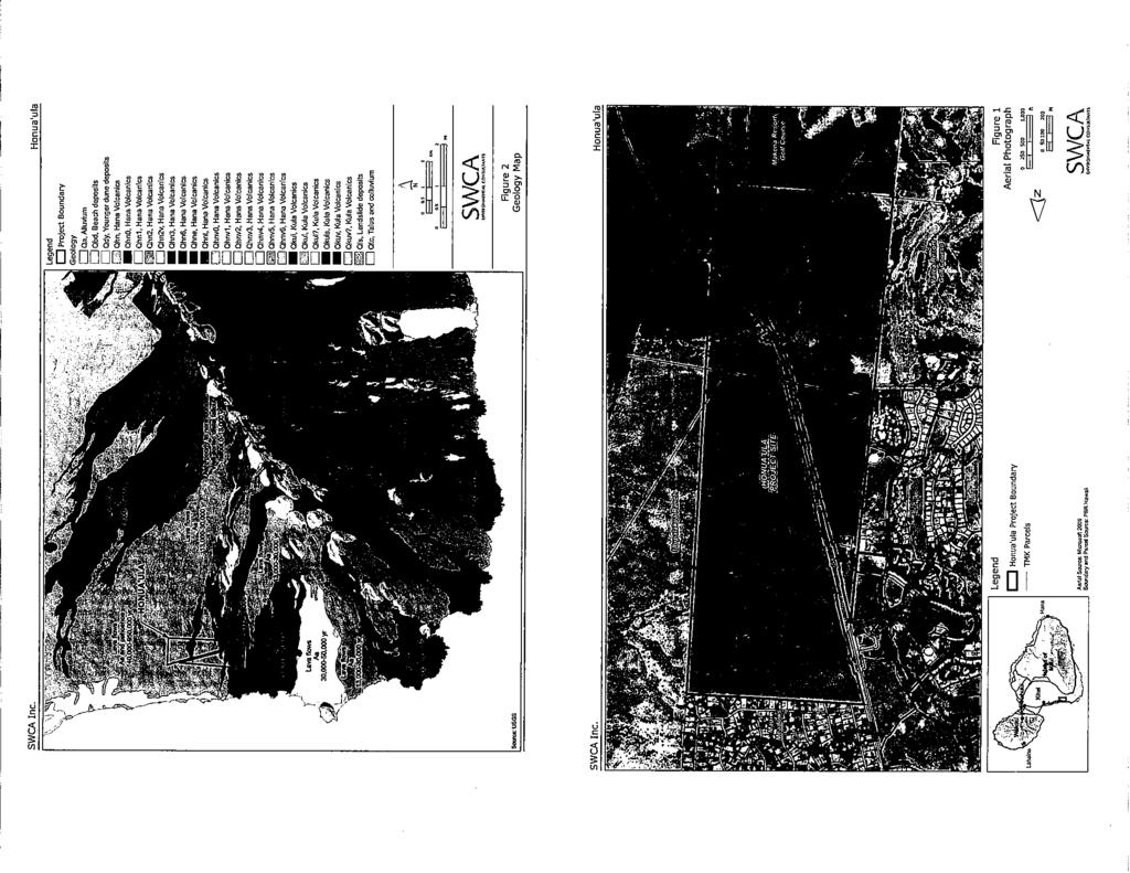
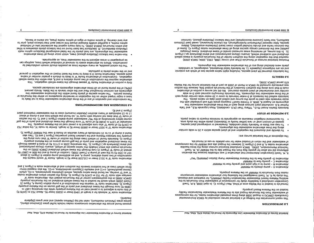
50 Terrestrial Flora and Fauna Survey of the Honua ula (Wailea 670) Water System Terrestrial Flora and Fauna Survey of the Honua ula (Wailea 670) Water System 1.0 INTRODUCTION Figure 1. Vicinity Map. In August 2010, SWCA Environmental Consultants (SWCA) was tasked by Honua ula Partners, LLC to conduct a terrestrial flora and fauna survey for a proposed conveyance system to provide both potable and non-potable water for the proposed Honua ula project. The survey was conducted in support of an Environmental Impact Statement (EIS) being prepared by PBR Hawaii & Associates, Inc. (PBR Hawaii), in compliance with Chapter 343 Hawaii Revised Statutes (HRS) and Habitat Conservation Plan (HCP) being prepared by SWCA under Section 10 of the Endangered Species Act (ESA) for the proposed Honua ula project. Honua ula is a master-planned, mixed-residential community encompassing a rectangular area of 271 hectares (ha) or 670 acres (ac) east of, and adjacent to, the existing Wailea Resort in K hei, Maui (Figure 1). It is bounded by the Maui Meadows subdivision to the north, the Makena Golf Course to the south, the Wailea Golf Course to the west, and the Ulupalakua Ranch to the east. The offsite components of the proposed private water system consist of: 1) brackish water wells within the subject well field; 2) one potable water storage tank and one non-potable water tank located mauka of the project area; and 3) waterlines to convey brackish water from the wells to the project area and the mauka tanks and then back to the project area. Water treatment and storage facilities and waterlines for the proposed water system also occur within the Honua ula project area (PBR Hawaii 2010). Puu o Kali quad Makena quad Haleakala Ranch < Well Field This report summarizes the findings of a terrestrial flora and fauna survey conducted by SWCA biologists Ling Ong, Ph.D., Shahin Ansari, Ph.D., Jaap Eijzenga, M.S., Tiffany Thair, M.S. candidate, and Ryan Taira, B.A. between August 30 and September 1, 2010 and on November 23, The survey area is shown in Figure 2. The objectives of the survey were: 1. To identify and document the presence and relative abundance of all plant species which occur within the survey area; 2. To provide a general description of the vegetation in the survey area; 3. To identify and document the presence and relative abundance (as appropriate) of bird, mammal, amphibian, reptile, and invertebrate macrofauna which occur within the survey area; 4. Identify and map any State- or Federally listed candidate, threatened, or endangered species, species of concern and/or rare (either locally or State-wide) species found or known to occur at the survey area. Honua ula < Ulupalakua Ranch Proposed Water Line 2.0 DESCRIPTION OF THE SURVEY AREA The survey area is located on the lower slopes of Haleakal in the K hei-m kena region on the leeward side of East Maui (Figure 1). The climate in the region is generally dry with an average annual rainfall ranging from 178 to 761 mm ( inches) and an annual average temperature of about 76 F (County of Maui 2008). The survey area can be divided into two distinct areas: 1) the well field; and 2) the water distribution line/tanks (Figure 2). < Proposed Reservoir The well field is a rectangular area located on agricultural land owned by Haleakal Ranch immediately north of the Maui Meadows subdivision and 4 km (2.5 mi) to the north of Honua ula. The area is designated for well development for Honua ula. The general topography of the well field is characterized as relatively flat to gently sloping westerly toward the ocean. Soils are primarily characterized as Keawakapu Extremely Stony Silty Clay Loam, 3 to 25% slopes, with a small area of Very Stony Land in the north (Foote et al. 1972). The substrate of the well field is primarily rocky. Several small drainage gulches, characterized by patches of exposed bedrock, transverse portions of the field; however, these intermittent gulches likely only carry water for a short time following intense rainfall events. Most of the field is underlain by a and p hoehoe lava flows ranging from 140,000 to 950,000 years old. A younger flow, between 13,000 and 30,000 years old, crosses the northern portion of the field (Sherrod et al. 2007). The younger flows have not undergone as extensive weathering and are characterized by a rough surface composed of broken a lava. Numerous jeep roads cross over the area. Legend Source(s): USGS; AECOM Proposed Water Line Well Field Honua'ula Boundary ,000 1,500 Meters ,000 2,000 3,000 4,000 5,000 Feet Wailuku!! Lahaina PROJECT SITE Kahului! Kihei! Island of Maui Hana! 2010 SWCA Environmental Consultants SWCA Environmental Consultants 2
51 Terrestrial Flora and Fauna Survey of the Honua ula (Wailea 670) Water System Terrestrial Flora and Fauna Survey of the Honua ula (Wailea 670) Water System Figure 2. Honua ula Water System Survey Area. Legend "/ Bird and Bat Count Station Source(s): USGS; AECOM 0 Botanical Survey Transect Proposed Water Line Well Field Honua'ula Boundary Meters 500 1,000 2,000 3,000 Feet Haleakala Ranch "/ "/ "/ "/ "/ < "/ Well Field The proposed water distribution line is located along the eastern (mauka) boundary of the Maui Meadows subdivision and proposed Honua ula project and adjacent areas within lands owned by Ulupalakua Ranch. A 9 m (30 ft) wide easement exists for the distribution line. It is anticipated that all construction related impacts would be confined to the easement; thus, our survey area for the distribution line is roughly 9 m wide. Two proposed offsite water storage tanks are located mauka of the distribution line at approximately 247 m (810 ft) elevation (PBR Hawaii 2010; Wilson Okamoto Corporation 2010). SWCA surveyed an area of approximately 0.25 ha (0.61 ac) for the tanks. SWCA also surveyed a 7 m (24 ft) wide and 229 m (750 ft) long area connecting the waterline from the Honua ula property line to the offsite tanks. This portion of the survey area is primarily flat, but slopes seaward near the proposed water tanks and slightly slopes seaward toward the adjacent residences. Soils are defined entirely as Keawakapu Extremely Stony Silty Clay Loam, 3 to 25% slopes (Foote et al. 1972). The majority of this area is underlain by a and p hoehoe lava flows ranging from 140,000 to 950,000 years old. A portion is underlain by a younger a flow between 55,000 and 140,000 years old (Sherrod et al. 2007). The landscape and vegetation in the area has been historically influenced by military training activities (WWII), invasion by non-native plants species, cattle grazing, grazing by feral ungulates, residential development, and fires (SWCA 2010a). Several components of the water system occur within the proposed Honua ula project area including one potable water tank, one non-potable water tank, a reverse osmosis plant, two brackish water wells, and portions of the distribution line. The flora and fauna of the Honua ula property were already surveyed by SWCA in 2008 (SWCA 2010a, 2010b). "/ "/ 3.0 PREVIOUS STUDIES Various flora and fauna surveys have been conducted within the nearby Honua ula property (Char and Linney 1988; Char 1993, 2004; Bruner 1988, 1993 and 2004; and SWCA 2006, 2009a, 2009b, 2010a and 2010b; Altenberg 2007); however, none have been conducted specifically within the areas where the offsite components of the water system are proposed. "/ "/ Ulupalakua Ranch As mentioned above, some of the components of the water system fall within the boundaries of the Honua ula property. Three distinct vegetation types are found within Honua ula: kiawe-buffelgrass (Prosopis pallida-cenchrus ciliaris) grassland, gulch vegetation, and mixed kiawe-wiliwili (Prosopis pallida-erythrina sandwicensis) shrubland (SWCA 2010a). All of the proposed onsite components of the water system occur within the kiawe-buffelgrass grassland of the Honua ula property. During SWCA s botanical survey of the project area in March and May 2008, no native plant species were identified within the footprint of the water system components within the Honua ula property. Honua ula "/ "/ "/ < Proposed Water Line No Blackburn s sphinx moths (Manduca blackburni), caterpillars or signs were observed within the footprint of the water system components on the Honua ula property by SWCA (2010b) or Bruner (1988, 1993 and 2004). SWCA biologists observed a single endangered Hawaiian hoary bat (Lasiurus cinereus semotus) flying seaward over the property at the southern boundary (SWCA 2010b). Sixteen species of introduced birds and one native bird, the pueo (Asio flammeus sandwichensis), have also been seen at Honua ula (SWCA 2010b). Prior surveys of the same parcel by Bruner (1988, 1993 and 2004) documented similar non-native avian species. Bruner (1988, 1994 and 2004) did not find pueo or the endangered Hawaiian hoary bat. "/ "/ "/ < Proposed Reservoir 4.0 SWCA SURVEY METHODS 4.1 Flora SWCA biologists initially conducted a literature review of available scientific and technical literature regarding natural resources within the vicinity of the survey area. A pedestrian survey of the area was conducted on August 31, September 1, and November 23, A Trimble GeoXT mapping-grade GPS unit preloaded with the study transects was used to guide the survey and collect point data on rare native plants (Figure 2). The SWCA botanists walked transects at 50 m (164 ft) intervals. Each botanist thoroughly scanned roughly 25 m (82 ft) on both sides of each transect and documented all plant species observed. Due to the exceptionally dry conditions in the survey area, the biologists 2010 SWCA Environmental Consultants SWCA Environmental Consultants 4
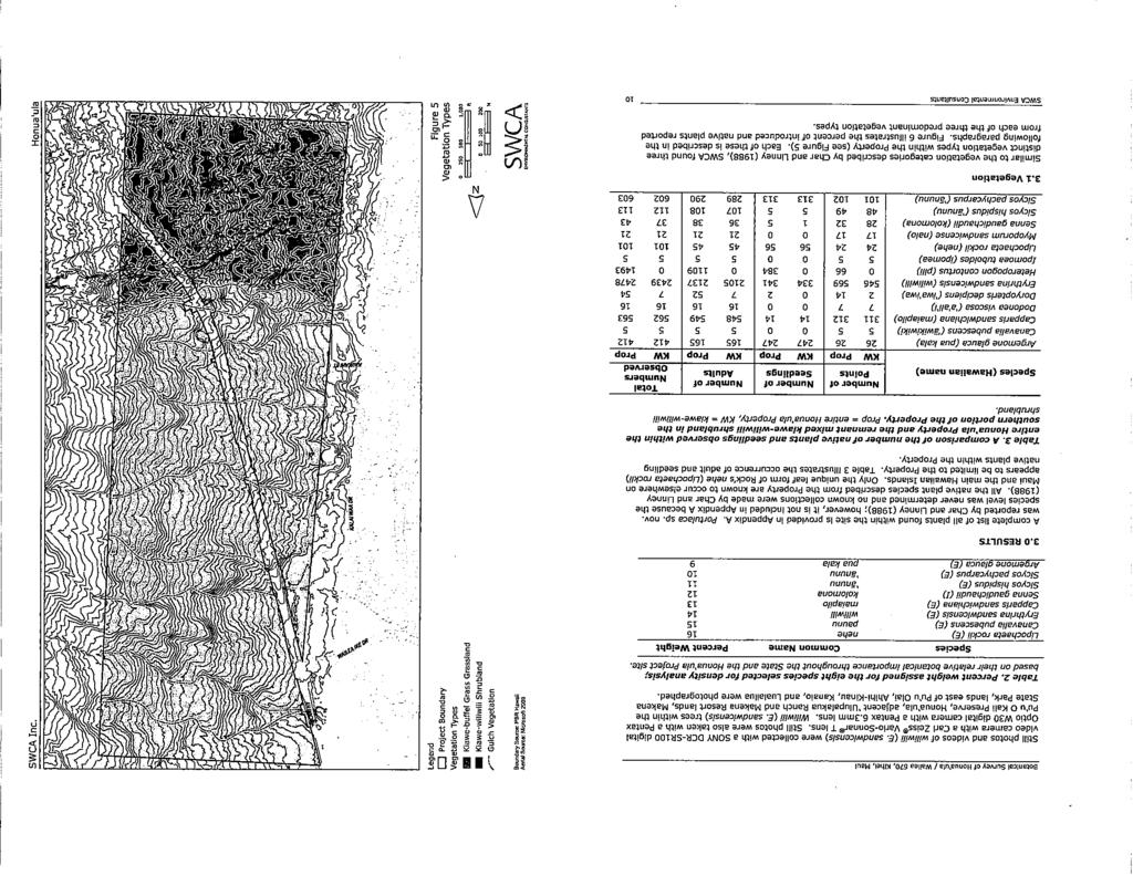
52 Terrestrial Flora and Fauna Survey of the Honua ula (Wailea 670) Water System Terrestrial Flora and Fauna Survey of the Honua ula (Wailea 670) Water System conducted more intensive searches of gullies, overhangs, steep slopes, shaded sites, and other areas most likely to support vegetation. All plant species observed within the survey area were documented and notes were made on their abundance and distribution, community structure, and disturbances. Plants were identified in the field wherever possible. Plants which could not be positively identified were collected for later determination in the herbarium and for comparison with the most recent taxonomic literature. Plants recorded during the survey are indicative of the season and environmental conditions at the time of the survey. This survey was conducted during an extensive drought period, which can mask the presence or identification of plant species known to occur in similar habitats within the region. It is possible that additional surveys conducted at a different time of the year, or after a significant rain event, would result in variations in the species and abundances of plants observed due to species present in the seed bank or dispersal from adjacent areas. 4.2 Fauna SWCA wildlife biologists conducted avian point count surveys on August 31, September 1, and November 23, Sixteen point count stations were placed within the study area (Figure 2). The location of the observer at each point count site was established in the field with a hand-held GPS receiver. Field observations of birds were recorded using 10 x 50 binoculars with a 6.5 degree field of vision. The observer also listened for avian vocalizations. The relative densities of species were estimated using eight-minute 100 m (328 ft) radius point counts (Lynch 1995) during peak bird activity periods ( , ) to maximize the likelihood of detecting birds during the survey. Birds observed between count stations were also noted. Mammals, reptiles, amphibians, insects, and other invertebrates seen or heard during the point count surveys or between count stations were also documented. SWCA biologists conducted evening surveys for the endangered Hawaiian hoary bat (Lasiurus cinereus semotus). Surveys were conducted on the evenings of August 30 and 31, and November 23, 2010 (between 1800 and 0000). The same point count stations for the avian fauna survey were used and each count station was sampled for eight minutes. These surveys were conducted under ideal weather conditions using night vision goggles (Morovison PVS-7 Ultra) during count stations surveyed after twilight. The detection distance for bats using night vision goggles was estimated to be 30 m (98 ft) radius at each point count station. Surveys for the endangered Blackburn s sphinx moth (Manduca blackburni) were conducted by inspecting non-native tree tobacco plants (Nicotiana glauca) encountered in the survey area. This species is a host plant used by the various life stages of Blackburn s sphinx moths. Leaves and stems were examined carefully for the presence or sign of moths, including frass (fecal matter), cut stems and leaves, and eggs. Normally, caterpillars and sign are expected to be more abundant in November to December following periods of heavy rainfall (USFWS 2005). 5.0 FINDINGS 5.1 Flora Thirty (30) plant species were recorded within the survey area, none of which are listed as threatened, endangered, or candidate endangered species or rare native Hawaiian plant species by the Federal or State governments. Six of these species (or 20% of the total species) are native to the Hawaiian Islands: wiliwili (Erythrina sandwicensis), uhaloa (Waltheria indica), pili grass (Heteropogon contortus), iwa iwa (Doryopteris decipiens), pua kala (Argemone glauca), and ilie e (Plumbago zeylanica). Of these, only wiliwili, iwa iwa, and pua kala are endemic, or found only in the Hawaiian Islands (Wagner et al. 1999; Palmer 2003). A list of all plant species observed by SWCA biologists within the survey area is included in Appendix 1 of this report. 3). Guinea grass (Urochloa maxima) and tree tobacco (Nicotiana glauca) are scattered throughout the field, and uhaloa is present on some of the rocky outcrops. A small wiliwili grove, consisting of six trees, occurs in the northeastern portion of the well field. As mentioned in Section 4 above, most of the vegetation in the well field was extremely dry or dead during the survey due to prolonged drought conditions in southeast Maui. Extensive grazing has also disturbed the vegetation in the area. The waterline/tanks portion of the survey area supports vegetation similar to that found in the well field. Kiawe trees are abundant in the canopy and buffelgrass is sparsely present in the understory (Figure 4). Several ornamental species are growing over the fence line from the adjacent subdivision such as Plumbago auriculata and coconut (Cocos nucifera). Other non-native weedy trees isolated throughout the distribution line area include koa haole (Leucaena leucocephala), African tulip tree (Spathodea campanulata), and chinaberry (Melia azedarach). 5.2 Fauna No State- or Federally listed threatened, endangered, or candidate bird, mammal, or insect species were observed during our survey. None of the fauna recorded by SWCA biologists during the survey are native to the Hawaiian Islands. Fifteen introduced bird species and a single migratory visiting bird species were recorded during the survey. Zebra doves (Geopelia striata) were notably the most abundant during the survey. Grey francolin (Francolinus pondicerianus), common myna (Acridotheres tristis), Japanese white-eye (Zosterops japonicus), and African silverbill (Lonchura cantans) were also common. All of these species are common to the main Hawaiian Islands, particularly in urban or disturbed areas (HAS 2005). The migratory Pacific golden-plover (Pluvialis fulva) or kolea was also heard during the survey. Several additional non-naturalized birds were also heard near the Maui Meadows subdivision including blue macaw (Cyanopsitta spixii), African grey parrot (Psittacus erithacus), and salmon-crested cockatoo (Cacatua moluccensis). The relative abundance of observed bird species is shown in Table 1. The avian diversity and abundance in the survey area is low, possibly due to the prolonged drought in the area. Based on observations at similar habitats at the nearby Honua ula project area under normal rainfall conditions, other birds that may occur in the area include Erckel s francolin (Francolinus erckelli), nutmeg manikin (Lonchura punctulata), and chestnut munia (Lonchura atricapilla). The native Hawaiian short-eared owl (Asio flammeus sandwichensis) and the introduced barn owl (Tyto alba) may also be expected to be in the area based upon previous surveys of adjacent lands (SWCA 2010b). The endangered Hawaiian hoary bat (Lasiurus cinereus semotus) was not seen during the three evenings. The only living mammals observed during the survey were mice (Mus domesticus), dogs (Canis lupus familiaris), mongoose (Herpestes javanicus), and axis deer (Axis axis). Skeletal remains of six cows (Bos taurus), and several deer were seen in the well field. Deer and cow droppings were reported from both areas. Although not observed, it is likely that non-native rats (Rattus spp.), and feral cats (Felis catus) also occur in the area. There are no native reptiles or amphibians in Hawai i (McKeown 1996). During the survey, geckos (Family: Gekkonidae) were heard, but not seen. Neither adult nor larval endangered Blackburn sphinx moths (Manduca blackburni) were observed by SWCA biologists during the survey. Despite the presence of the tree tobacco (Nicotiana glauca), a non-native larval host plant, no sign of the Blackburn sphinx moth (e.g., cut stems and leaves, frass and eggs) was observed. Other insects and invertebrates observed in the survey area include the carpenter bee (Xylocopa sonorina), moths (Order: Lepidoptera), including a large number of koa haole moths (Macaria abydata) and dragonflies (Order: Odonata). The vegetation in the well field portion of the survey area is characterized as kiawe-buffelgrass (Prosopis pallida-cenchrus ciliaris) grassland. The kiawe trees range from 4.5 to 8 m (15-26 ft) tall with sparse buffelgrass cover in the understory due to dry conditions and grazing by ungulates (Figure 2010 SWCA Environmental Consultants SWCA Environmental Consultants 6
 Status Birds per point count (n=16) Abundance Rank ARDEIDAE Bulbulcus ibis Cattle egret X 0.")

53 Terrestrial Flora and Fauna Survey of the Honua ula (Wailea 670) Water System Terrestrial Flora and Fauna Survey of the Honua ula (Wailea 670) Water System Table 1. Relative abundance of birds observed during point counts. Species Name Common Name(s) Status Birds per point count (n=16) Abundance Rank ARDEIDAE Bulbulcus ibis Cattle egret X PHASIANIDAE Francolinus francolinus Black francolin X Francolinus pondicerianus Grey francolin X CHARADRIIDAE Pluvialis fulva Pacific golden-plover V * * COLUMBIDAE Geopelia striata Zebra dove X Streptopelia chinensis Spotted dove X Zenaida macroura Mourning dove X ZOSTEROPIDAE Zosterops japonicus Japanese white-eye X Figure 3. View of the drought stricken kiawe-buffelgrass (Prosopis pallida-cenchrus ciliaris) grassland in the well field portion of the survey area. MIMIDAE Mimus polyglottos Northern mockingbird X STURNIDAE Acridotheres tristis Common myna X EMBERIZIDAE Cardiinalis cardinalis Northern cardinal X Paroaria coronata Red-crested cardinal X FRINGILLIDAE Carpodacus mexicanus House finch X PASSERIDAE Padda oryzivora Java sparrow X Passer domesticus House sparrow X Lonchura cantans African silverbill X Unknown 1.50 * = observed outside of point count stations. X = non-native/introduced to the Hawaiian Islands. V = visitor; seasonally present in the Hawaiian Islands. 6.0 CONCLUSIONS AND RECOMMENDATIONS Figure 4. View of kiawe trees (Prosopis pallida) and sparse buffelgrass (Cenchrus ciliaris) cover near the Maui Meadows subdivision along the proposed distribution line. No Federal or State candidate, proposed or listed threatened or endangered species were observed or previously reported to be within the proposed well field, waterline, or tank areas. The majority of the species observed in the proposed water system area (80% of the flora and over 95% of the birds and mammals) are introduced to the Hawaiian Islands. Most of the native plants observed during the survey are commonly found throughout Maui and the main Hawaiian Islands. Of the native plants in the survey area, only wiliwili has a limited distribution throughout the Hawaiian Islands. It remains locally common in southeastern Maui. The only native bird species recorded during the survey - the 2010 SWCA Environmental Consultants SWCA Environmental Consultants 8
54 Terrestrial Flora and Fauna Survey of the Honua ula (Wailea 670) Water System Terrestrial Flora and Fauna Survey of the Honua ula (Wailea 670) Water System Pacific golden-plover - is abundant throughout Hawai i and uses a variety of habitats including mudflats, lawns and rooftops (HAS 2005). As stated above, this survey was conducted during an extensive drought period, which can possibly mask the presence or identification of plant species known to occur in similar habitats within the region. It is possible that additional surveys conducted at a different time of the year or after a significant rain event would result in variations in the species and abundances of plants observed due to species present in the seed bank or dispersal from adjacent areas. Patches of native plants [e.g., wiliwili (Erythrina sandwicensis) and maiapilo (Capparis sandwichiana)] do occur in the vicinity of the well field in the adjacent younger lava flows. Based on findings of this survey and the results of prior flora and fauna surveys within the Honua ula project area, no intact native ecosystems are expected to be impacted by the proposed well development and waterline transmission work associated with the Honua ula development. Furthermore, given that the survey area has been highly altered by human activity and lacks any native species or habitats of special concern, the proposed work is not expected to result in any significant adverse impact on the flora or fauna in this part of Maui. Wiliwili trees throughout Maui were damaged or destroyed during the statewide outbreak of the invasive gall wasp (Quadrastichus erythrinae). Protecting local surviving wiliwili tress will contribute to enhancing the island-wide population of this endemic species. It is recommended that during construction of the water system the wiliwili trees located in the northern portion of the well field and within the proposed waterline be avoided to the maximum extent possible. If non-native tree tobacco plants need to be removed or disturbed while conducting the proposed work, the plants should first be surveyed by a qualified biologist for the presence of Blackburn s sphinx moth eggs, larvae, or signs indicating the possibility of pupating larvae (frass, chewed stems or other browsing characteristic of Blackburn s sphinx moth on tree tobacco plants). If the tree tobacco plant is entirely herbaceous (such as a small un-branched young plant), and there are no Blackburn s sphinx moth eggs, larvae, or signs indicating the possibility of pupating larvae, the plant may be removed by the roots. If Blackburn s sphinx moth eggs, larvae, or signs indicating the possibility of pupating larvae (such as frass, chewed stems or other browsing characteristic of Blackburn s sphinx moth on the plant) are observed, the USFWS recommends that the plant not be removed until the plants are free of Blackburn s sphinx moth eggs and larvae. Then the following steps should be taken to minimize potential impacts to Blackburn s sphinx moth individuals: If the plant is woody and there are no Blackburn s sphinx moth eggs, larvae, or signs indicating the possibility of pupating larvae (such as frass, chewed stems or other browsing characteristic of Blackburn s sphinx moth on the plant), the above-ground portion of the plant may be cut off and removed. If the plant has developed woody structure, it is possible that the signs of Blackburn s sphinx moth foraging have been shed and that root disturbance could dislodge larvae. Therefore, the soil and plant roots should be left undisturbed for a one-year period. A 10 m (33 ft) buffer should be established around the woody host plant to prevent disturbance to any pupating larvae which may be in the ground in the area around the plant. Cut stems should be maintained to be free of re-growth (by either carefully painting herbicide on the cut stem or frequent hand clipping) to prevent leaf growth and potential use by the moth. After one year, the plant roots may be removed. Because Blackburn s sphinx moth larvae burrow into the substrate near host plants and may remain in a state of torpor for up to a year before emerging from the soil (USFWS 2005), soil disturbance at the base of the tobacco plants may harm Blackburn s sphinx moth larvae. The one-year period will ensure any larvae pupating in the soil will have pupated and emerged from soil prior to disturbance of the plant or soil. During construction of the wells, waterline, and storage tanks, care should be taken to minimize the introduction of new weeds into the area. All vehicles, entering or leaving the construction site should be thoroughly cleaned (preferably pressure washed). If landscaping is included as part of the proposed water system, native plants should be employed to the maximum extent practicable. If native plants do not meet landscaping objectives, plants with a low risk of becoming invasive may be substituted. Additional information can be gleaned from the following websites for use in selecting appropriate native species for landscaping: Native Plants Hawai i ( Pacific Island Ecosystems at Risk ( and Weed Risk Assessments for Hawai i and Pacific Islands ( 7.0 LITERATURE CITED Altenberg, L Remnant Wiliwili forest habitat at Wailea 670, Maui, Hawaii. Available at: Accessed October 16, American Ornithologists Union (AOU) List of The 2,037 Bird Species (With Scientific and English Names) Known From The A.O.U. Checklist Area. 55 pp. Bruner, P.L Survey of the avifauna and feral mammals at Makena 700 property, Makena, Maui. Contract report prepared for PBR Hawaii Faunal (bird and mammal) survey of Wailea Ranch (Maui Wailea 670), Maui. Contract report prepared for PBR Hawaii Avifaunal and feral mammal field survey of Wailea 670, Maui. Contract report prepared for PBR Hawaii. Char, W.P Wailea Ranch (Maui Wailea 670) Botanical Survey Update, letter report dated 19 July 1993 to D. Hulse, PBR Hawaii Wailea 670 Property Botanical Resources Update, letter report dated 30 August 2004 to Charles Jencks, Wailea 670 Associates. Char, W.P., and G.K. Linney Botanical Survey Maui Wailea 670 Project Wailea, Makawao District, Island of Maui. Contract report prepared for PBR Hawaii. County of Maui Maui County Data Book Available at: Accessed September 16, Evenhuis, N.L. and L.G. Eldredge (eds.) Records of the Hawaii Biological Survey. Bishop Museum Occasional Papers No Foote, D.E., E.L. Hill, S. Nakamura, and F. Stephens Soil Survey of the Islands of Kaua i, O ahu, Maui, Moloka i, and L na i, State of Hawai i. U.S. Department of Agriculture, Soil Conservation Service. HAS (Hawaii Audubon Society) Hawaii s Birds, 6 th Edition. Honolulu, Hawaii. 141 pp. Lynch, J.F Effects of point count duration, time-of-day, and aural stimuli on detectability of migratory and resident bird species in Quintana Roo, Mexico. USDA Forest Service General Technical Report PSW-GTR-149. McKeown, S A field guide to reptiles and amphibians in the Hawaiian Islands. Los Osos, CA.: Diamond Head Publishing. Palmer, D.D Hawai i s Ferns and Fern Allies. Honolulu: University of Hawai i Press. PBR Hawaii Honua ula Draft Environmental Impact Statement. Prepared for Maui Planning Department/Maui Planning Commission. Sherrod, D.R., J.M. Sinton, S.E. Watkins, and K.M. Brunt Geological Map of the State of Hawai i. U.S. Geological Survey Open-File Report , Version SWCA Environmental Consultants SWCA Environmental Consultants 10
55 Terrestrial Flora and Fauna Survey of the Honua ula (Wailea 670) Water System Staples, G.W., and D.R. Herbst A Tropical Garden Flora: Plants Cultivated in the Hawaiian Islands And Other Tropical Places. Honolulu: Bishop Museum Press. SWCA (Environmental Consultants) Draft conservation and stewardship plan, Honua ula/ Wailea 670, K hei, Maui. Contract report prepared for WCPT/GW Land Associates, LLC, May a. Botanical survey of Honua ula (Wailea 670), K hei, Maui. Contract report prepared for Honua ula Partners, LLC. March b. Wildlife survey of Honua ula (Wailea 670), K hei, Maui. Contract report prepared for Honua ula Partners, LLC. March a. Botanical Survey of Honua ula/wailea 670, Kihei, Maui. Contract report prepared for Honua ula Partners, LLC. Updated January b. Wildlife Survey of Honua ula/wailea 670, Kihei, Maui. Contract report prepared for Honua ula Partners, LLC. Updated February c. Honua ula/wailea 670 Conservation & Stewardship Plan, Kihei, Maui. Contract report prepared for Honua ula Partners, LLC. USFWS (U.S. Fish and Wildlife Service) Recovery plan for the Blackburn s sphinx moth (Manduca blackburni). Portland, OR. Wagner, W.L., D.R. Herbst, and S.H. Sohmer Manual of the flowering plants of Hawaii. Honolulu: University of Hawaii Press and Bishop Museum Press. Wagner, W.L., and D.R. Herbst Supplement to the Manual of the Flowering Plants of Hawaii. Version 3.1 (12 Dec 2003). Available online at: Accessed September 17, Wilson Okamoto Corporation Preliminary Engineering Report, Honua ula, Wailea, Maui. Appendix P of the Honua ula Draft Environmental Impact Statement. Prepared for Honua ula Partners, LLC SWCA Environmental Consultants 11 Terrestrial Flora and Fauna Survey of the Honua ula (Wailea 670) Water System APPENDIX 1: List of Plant Species Observed The following checklist is an inventory of all the plant species observed by SWCA biologists at the proposed Honua ula private water system survey area in K hei-m kena, Maui, Hawai i. The plant names are arranged alphabetically by family and then by species into three groups: Ferns, Monocots, and Dicots. The taxonomy and nomenclature of the flowering plants are in accordance with Wagner et al. (1999), Wagner and Herbst (2003), and Staples and Herbst (2005). Fern taxonomy follows Palmer (2003). Recent name changes are those recorded in the Hawaii Biological Survey series (Evenhuis and Eldredge ). Status: E = endemic = native only to the Hawaiian Islands. I = indigenous = native to the Hawaiian Islands and elsewhere. P = Polynesian = introduced by Polynesians. X = introduced/ alien = all those plants brought to the Hawaiian Islands by humans, intentionally or accidentally, after Western contact (Cook s arrival in the islands in 1778). Abundance Location: Field = Proposed well field on Haleakal Ranch land. Dist/Tank = Proposed distribution line and tanks on Ulupalakua Ranch land. Relative Site Abundance: Abundant = forming a major part of the vegetation within the survey area. Common = widely scattered throughout the area or locally abundant within a portion of the area. Uncommon = scattered sparsely throughout the area or occurring in a few small patches. Rare = only a few isolated individuals within the survey area. Scientific Name Hawaiian, Common Name(s) Status Field Abundance Dist/Tank FERNS Adiantaceae Doryopteris decipiens (Hook.) J. Sm. iwa iwa E Rare MONOCOTS Aloeaceae Aloe vera (L.) Burm.f. aloe X Rare 2010 SWCA Environmental Consultants 12
56 Terrestrial Flora and Fauna Survey of the Honua ula (Wailea 670) Water System Arecaceae Scientific Name Hawaiian, Common Name(s) Status Field Abundance Cocos nucifera L. niu, ololani, coconut P Rare Poaceae Dist/Tank Cenchrus ciliaris L. buffelgrass X Abundant Abundant Heteropogon contortus (L.) P.Beauv. ex Roem. & Schult. pili, lule I Rare Rare Urochloa maxima (Jacq.) R.D. Webster Guinea grass X Uncommon Uncommon DICOTS Asclepiadaceae Calotropis gigantea (L.) W.T.Aiton crownflower, giant milkweed X Rare Tridax procumbens L. coat buttons X Rare Asteraceae Senecio madagascariensis Poiret fireweed X Rare Verbesina encelioides (Cav.) Benth. & Hook golden crown beard X Rare Bignoniaceae Spathodea campanulata P.Beauv. African tulip tree X Rare Cactaceae Opuntia ficus-indica (L.) Mill. panini X Rare Pilocereus royenii (L.) Byles & Rowley Royen s tree cactus X Rare Cucurbitaceae Momordica charantia L. balsam pear, bitter melon X Rare Euphorbiaceae Chamaesyce hypercifolia (L.) Millsp. graceful spurge X Rare Rare 2010 SWCA Environmental Consultants 13 Terrestrial Flora and Fauna Survey of the Honua ula (Wailea 670) Water System Fabaceae Scientific Name Hawaiian, Common Name(s) Status Field Abundance Erythrina sandwicensis O.Deg. wiliwili E Rare Rare Indigofera suffritocosa Mill. iniko X Rare Dist/Tank Leucaena leucocephala (Lam.) de Wit koa haole X Uncommon Uncommon Macroptilium lathyroides (L.) Urb. wild bean, cow pea X Rare Prosopis pallida (Humb. & Bonpl. Ex Willd.) Kunth Lamiaceae kiawe X Abundant Abundant Leonotis nepetifolia (L.) R.Br. lion s ear X Rare Malvaceae Abutilon grandifolium (Willd.) Sweet hairy abutilon, ma o X Rare Rare Malvastrum coromandelianum (L.) Garcke false mallow X Rare Meliaceae Melia azedarach L. chinaberry, pride-of-india X Rare Papavaraceae Argemone glauca (Nutt. Ex Prain (Pope) pua kala E Rare Plumbaginaceae Plumbago auriculata Lam. X Rare Plumbago zeylanica L. ilie e I Rare Solanaceae Nicotiana glauca R.C. Graham tree tobacco X Uncommon Sterculiaceae Waltheria indica L. uhaloa I Uncommon Rare Verbenaceae Lantana camara L. Sacramento bur X Rare Rare 2010 SWCA Environmental Consultants 14
Wildlife Survey. Appendix H
 Wildlife Survey Appendix H Wildlife Survey of Honua ula (Wailea 670) K hei, Maui Prepared for Honua ula Partners, LLC 381 Huku Li i Place, Suite 202 K hei, Maui 96753 Prepared by SWCA Environmental Consultants
ARE ENDANGERED BIOLOGICAL RESOURCES THREATENED BY REZONING MAKENA RESORT PROPERTY?
 Testimony on zoning change request by Makena Resort Corp. ARE ENDANGERED BIOLOGICAL RESOURCES THREATENED BY REZONING MAKENA RESORT PROPERTY? by Lee Altenberg, Ph.D. Associate Professor, Information and
National Park Service U.S. Department of the Interior. Haleakala National Park Makawao, Maui, Hawai'i
 National Park Service U.S. Department of the Interior Haleakala National Park Makawao, Maui, Hawai'i HAWAIIAN PETRELS NEAR THE HALEAKALÄ OBSERVATORIES: A REPORT TO K. C. ENVIRONMENTAL, CO. INC. FOR PREPARATION
APPENDIX G. Biological Resources Reports
 APPENDIX G Biological Resources Reports November 9, 2009 David Geiser Merlone Geier Management, LLC 3580 Carmel Mountain Rd., Suite 260 San Diego, California 92130 RE: Neighborhood at Deer Creek, Petaluma,
Appendix C-2. Nesting Bird Survey
 Appendix C-2 April 27, 2014 Rincon Project Number: 14-00929 Glassell Park, LLC Attn: Nancy Johns 23622 Calabasas Road, Suite 220 Calabasas, California 91302 Via Email: wildflowerdevelopment@yahoo.com Subject:
HALEAKALA NATIONAL PARK CRATER DISTRICT RESOURCES BASIC INVENTORY: BIRDS OF THE CRATER DISTRICT
 71 HALEAKALA NATIONAL PARK CRATER DISTRICT RESOURCES BASIC INVENTORY: BIRDS OF THE CRATER DISTRICT Sheila Conant Department of General Science and Maile A. Stemmermann Depar tment of Zoology University
Golden Eagle (Aquila chrysaetos) Management Indicator Species Assessment Ochoco National Forest
 Management Indicator Species Assessment Ochoco National Forest") Golden Eagle (Aquila chrysaetos) Management Indicator Species Assessment Ochoco National Forest I. Introduction The golden eagle was chosen as a terrestrial management indicator species (MIS) on the Ochoco
Golden Eagle (Aquila chrysaetos) Management Indicator Species Assessment Ochoco National Forest I. Introduction The golden eagle was chosen as a terrestrial management indicator species (MIS) on the Ochoco
Comments on the Guam Military Buildup Draft Environmental Impact Statement (DEIS)
") Comments on the Guam Military Buildup Draft Environmental Impact Statement (DEIS) Mariana eight spot butterfly, Hypolimnas octocula marianensis, male. Image from Butterflies of Micronesia by Ise H. Schreiner
Comments on the Guam Military Buildup Draft Environmental Impact Statement (DEIS) Mariana eight spot butterfly, Hypolimnas octocula marianensis, male. Image from Butterflies of Micronesia by Ise H. Schreiner
PART FIVE: Grassland and Field Habitat Management
 PART FIVE: Grassland and Field Habitat Management PAGE 64 15. GRASSLAND HABITAT MANAGEMENT Some of Vermont s most imperiled birds rely on the fields that many Vermonters manage as part of homes and farms.
4-H Conservation Guidelines
 4-H Conservation Guidelines The following are guidelines for providing learning experiences in the conservation project area. THE GUIDELINES FOR ALL MEMBERS Understand what Natural Resources are; how to
Least Bell's Vireo & Western Burrowing Owl Surveys
 I - 15 CORRIDOR CAMPUS MASTER PLAN DRAFT EIR MT. SAN JACINTO COMMUNITY COLLEGE DISTRICT Appendices Appendix D5 Least Bell's Vireo & Western Burrowing Owl Surveys August 2017 I - 15 CORRIDOR CAMPUS MASTER
Results of Nesting Bird Survey in Support of Fiscalini Ranch Forest Test Plots, Cambria, California
 May 26, 2016 Carlos Mendoza Cambria Community Services District 1316 Tamsen Drive, Suite 201 Cambria, California 93428 RE: Results of Nesting Bird Survey in Support of Fiscalini Ranch Forest Test Plots,
Work Plan for 2015 Pre- Construction Avian and Bat Surveys Swanton Wind Project
 Work Plan for 2015 Pre- Construction Avian and Bat Surveys Swanton Wind Project Swanton Wind Project Swanton, Vermont Prepared for: Vermont Environmental Research Associates 1209 Harvey Farm Road Waterbury
Loggerhead Shrike (Lanius ludovicianus)
") Loggerhead Shrike (Lanius ludovicianus) NMPIF level: Species Conservation Concern, Level 2 (SC2) NMPIF Assessment score: 14 NM stewardship responsibility: Moderate National PIF status: No special status
Loggerhead Shrike (Lanius ludovicianus) NMPIF level: Species Conservation Concern, Level 2 (SC2) NMPIF Assessment score: 14 NM stewardship responsibility: Moderate National PIF status: No special status
The Quail Valley study area is located in the hills surrounding Railroad Canyon Reservoir, approximately 4 miles east of Lake Elsinore.
 County of Riverside - PSEC Project General Habitat Assessment Appendix A Quail Valley Quail Valley The Quail Valley study area is located in the hills surrounding Railroad Canyon Reservoir, approximately
Fruits and vegetables Insect infested plants Noxious weeds, cut flowers, branches, and coconut products Ornamental plants...
 The Unwanteds Grades 4 6 Lesson at a Glance: Students read and discuss a story of how voyaging canoe crews prevented no-no flies from entering Hawai i. Groups of students then become invaders and inspectors
Chapter-VIII SUMMARY AND CONCLUSION
 Chapter-VIII SUMMARY AND CONCLUSION Andaman and Nicobar Islands are very rich in bird diversity and hence have high importance in conservation planning. Both in species endemism and species diversity these
12 March Terra Nova Planning and Research 400 S. Farrell Drive, Suite B-205 Palm Springs, CA (760) (FAX)
 (FAX)") 12 March 2010 Terra Nova Planning and Research 400 S. Farrell Drive, Suite B-205 Palm Springs, CA 92262 (760) 320-9040 (FAX) 322-2760 ATTN: John Criste RE: Altamira (TT 18255) Update to April 2007 Report
12 March 2010 Terra Nova Planning and Research 400 S. Farrell Drive, Suite B-205 Palm Springs, CA 92262 (760) 320-9040 (FAX) 322-2760 ATTN: John Criste RE: Altamira (TT 18255) Update to April 2007 Report
STATEMENT OF QUALIFICATIONS
 STATEMENT OF QUALIFICATIONS Southern Nevada Environmental, Inc. (SNEI) is a certified Women and Minority-owned Small Business Enterprise, with offices in Las Vegas NV, and Victorville CA. SNEI is recognized
Chapter 5: MIP Elepaio Management
 5-1 Chapter 5: MIP Elepaio Management The initial Biological Opinion (BO) that triggered the development of the Mākua Implementation Plan (MIP) was issued in 1999. At that time, the O ahu Elepaio (Chasiempis
RAPTOR SURVEYS CONDUCTED AT NEAR WEST 2013 RESOLUTION COPPER MINING
 RAPTOR SURVEYS CONDUCTED AT NEAR WEST 2013 RESOLUTION COPPER MINING Prepared for: 102 Magma Heights PO Box 1944 Superior, Arizona 85173 Prepared by: 4001 E Paradise Falls Drive Tucson, Arizona 85712 April
Peregrine Falcon Falco peregrinus
 Plant Composition and Density Mosaic Distance to Water Prey Populations Cliff Properties Minimum Patch Size Recommended Patch Size Home Range Photo by Christy Klinger Habitat Use Profile Habitats Used
2017 Monarch Butterfly Conservation Fund Grant Slate
 2017 Monarch Butterfly Conservation Fund Grant Slate NFWF CONTACT Todd Hogrefe Director, Central Regional Office todd.hogrefe@nfwf.org 612-564-7286 PARTNERS Monarch butterflies ABOUT NFWF The National
Mesquite-Acacia. Conservation Profile 11,400 ha [28,200 acres] 0.04% of state. Key Bird-Habitat Attributes. Hab-10-1
![Mesquite-Acacia. Conservation Profile 11,400 ha [28,200 acres] 0.04% of state. Key Bird-Habitat Attributes. Hab-10-1](/thumbs/74/70299362.jpg "Mesquite-Acacia. Conservation Profile 11,400 ha [28,200 acres] 0.04% of state. Key Bird-Habitat Attributes. Hab-10-1") Mesquite bosque near Corn Creek, Clark County. Photo by Elisabeth Ammon. Key Bird-Habitat Attributes Stand Structure Ideal Scale for Conservation Action Plant Species Composition Plant Condition Distance
Mesquite bosque near Corn Creek, Clark County. Photo by Elisabeth Ammon. Key Bird-Habitat Attributes Stand Structure Ideal Scale for Conservation Action Plant Species Composition Plant Condition Distance
* * * * * * * * * * * * * * * * For Judges Use Only
 Welcome to the Wildlife O-Rama! SENIOR KEY NAME: COUNTY: * * * * * * * * * * * * * * * * For Judges Use Only Score Wildlife ID (30 pts) Wildlife Foods (15 pts) Wildlife Concepts (15 pts) Total RANK: Wildlife
Roberts Bank Terminal 2 Project Field Studies Information Sheet
 January 2013 Port Metro Vancouver is continuing field studies in January as part of ongoing environmental and technical work for the proposed. The is a proposed new multi berth container terminal which
Grassland Bird Survey Protocol Sauvie Island Wildlife Area
 Grassland Bird Survey Protocol Sauvie Island Wildlife Area Project Objective: Help determine if native grassland bird species are benefiting from restoration of grassland/pasture habitats at the Sauvie
Establishment of Additional Monarch Butterfly Host Plants at the Sand Hill Lakes Mitigation Bank
 Establishment of Additional Monarch Butterfly Host Plants at the Sand Hill Lakes Mitigation Bank David Clayton Environmental Scientist III David.Clayton@nwfwater.com Northwest Florida Water Management
Say s Phoebe Sayornis saya Conservation Profile
 Ed Harper Habitat Use Profile Habitats Used in California Grasslands, 1,2 open areas with bare ground, 3 agricultural areas 1 Key Habitat Parameters Plant Composition No plant affinities known. Plant Density
Natural Heritage Inventory and Evaluation for the Medway Valley Heritage Forest South ESA. Public Meeting January 27, 2014
 Natural Heritage Inventory and Evaluation for the Medway Valley Heritage Forest South ESA Welcome! Tonight you will have the opportunity to learn and comment on: Purpose of the Inventory and Evaluation
Camera Trap Reconnaissance of Wildlife in the Napatree Point Conservation Area: Sampling
 Camera Trap Reconnaissance of Wildlife in the Napatree Point Conservation Area: 2016-2017 Sampling Peter August 1, Janice Sassi 2 & Scott Rasmussen 1 1 Department of Natural Resources Science, University
MIGRATORY LANDBIRD CONSERVATION REPORT MOSQUITO GRAZING ALLOTMENT MANAGEMENT PROJECT AMERICAN RIVER RANGER DISTRICT TAHOE NATIONAL FOREST
 MIGRATORY LANDBIRD CONSERVATION REPORT MOSQUITO GRAZING ALLOTMENT MANAGEMENT PROJECT AMERICAN RIVER RANGER DISTRICT TAHOE NATIONAL FOREST Prepared By: Roy Bridgman Wildlife Biologist American River Ranger
Work Plan for Pre-Construction Avian and Bat Surveys
 Work Plan for Pre-Construction Avian and Bat Surveys, Steuben County, New York Prepared For: EverPower Wind Holdings, Inc. 1251 Waterfront Place, 3rd Floor Pittsburgh, PA 15222 Prepared By: Stantec Consulting
Jackson Bottom Wetlands Preserve BCS Number: 47-14
 Jackson Bottom Wetlands Preserve BCS Number: 47-14 Site description author(s) Greg Gillson, Jackson Bottom Wetlands Preserve Primary contact for this site Ed Becker, Natural Resources Manager, Jackson
Atrytone arogos (Boisduval & LeConte), 1834 Arogos Skipper (Hesperiidae: Hesperiinae) SUMMARY
, 1834 Arogos Skipper (Hesperiidae: Hesperiinae) SUMMARY") Shepherd, M. D. 2005. Species Profile: Atrytone arogos. In Shepherd, M. D., D. M. Vaughan, and S. H. Black (Eds). Red List of Pollinator Insects of North America. CD-ROM Version 1 (May 2005). Portland,
Shepherd, M. D. 2005. Species Profile: Atrytone arogos. In Shepherd, M. D., D. M. Vaughan, and S. H. Black (Eds). Red List of Pollinator Insects of North America. CD-ROM Version 1 (May 2005). Portland,
Baskett Slough National Wildlife Refuge BCS number: 47-4
 Baskett Slough National Wildlife Refuge BCS number: 47-4 Site description author(s) Daphne E. Swope, Research and Monitoring Team, Klamath Bird Observatory Primary contact for this site N/A Location (UTM)
Shrubland Bird Ecology & Management. What are shrublands?
 Shrubland Bird Ecology & Management Matt Tarr Associate Extension Professor Wildlife Specialist University of New Hampshire Cooperative Extension Shrublands are habitats: dominated by shrubs and young
Mexican Spotted Owl Monitoring and Inventory from in the Lincoln National Forest, New Mexico
 Mexican Spotted Owl Monitoring and Inventory from 2001-2005 in the Lincoln National Forest, New Mexico Submitted to: Rene Guaderrama Lincoln National Forest Sacramento Ranger District P. O. Box 288 Cloudcroft,
Ferruginous Hawk Buteo regalis
 Photo by Teri Slatauski Habitat Use Profile Habitats Used in Nevada Sagebrush Pinyon-Juniper (Salt Desert Scrub) Key Habitat Parameters Plant Composition Sagebrush spp., juniper spp., upland grasses and
Mixed Conifer Working Group Meeting February 17, 2011 Wildlife Habitat Management Considerations
 Mixed Conifer Working Group Meeting February 17, 2011 Wildlife Habitat Management Considerations Overview 1. Existing mixed conifer habitat 2. Habitat trends 3. Factors influencing wildlife habitat suitability
Habitat Use by Wildlife in Agricultural and Ranching Areas in the Pantanal and Everglades. Dr. Júlio Cesar de Souza and Dr. Elise V.
 Habitat Use by Wildlife in Agricultural and Ranching Areas in the Pantanal and Everglades Dr. Júlio Cesar de Souza and Dr. Elise V. Pearlstine Pantanal 140,000 km 2 of wetlands with a monomodal flood pulse
Roberts Bank Terminal 2 Project Field Studies Information Sheet
 May 2013 Port Metro Vancouver is continuing field studies in May as part of ongoing environmental and technical work for the proposed Roberts Bank Terminal 2 Project. Roberts Bank Terminal 2 Project The
Effects of Herbaceous Field Borders on Farmland Birds in the Mississippi Alluvial Valley
 Technical Note July 26 Effects of Herbaceous Field Borders on Farmland Birds in the Mississippi Alluvial Valley Issued July 26 Information for this report was modified from the M.S. research of Ross R.
Arkansas Wildlife Action Plan, State Wildlife Grants Pre-proposal - Cover Page
 Arkansas Wildlife Action Plan, State Wildlife Grants Pre-proposal - Cover Page Project Title: Prairie Restoration of an abandoned railroad to benefit grassland birds and insects in the Grand Prairie Region
Expansion Work Has Begun The perimeter dike for Cell 7 is now visible
 Summer/Fall 2017 In This Issue Poplar Island Expansion Wetland Cell 5AB Development Wildlife Update Birding tours on Poplar Island Expansion Work Has Begun The perimeter dike for Cell 7 is now visible
Re: Environmental Review for Proposed Palmer Solar Project in El Paso County
 Southeast Region, Area 14 4255 Sinton Road Colorado Springs, CO 80907 P 719.227.5200 F 719.227.5223 May 21, 2018 juwi Inc. 1710 29 th Street, Suite 1068 Boulder, CO 80301 Re: Environmental Review for Proposed
HAWAIIAN HAWK NESTING STUDY Spring 1984
 HAWAIIAN HAWK NESTING STUDY Spring 1984 Maile Stemmermann P.O. Box 476 Volcano, HI 96785 .. ~ ". INTRODUCTION The Puna geothermal resource area has been the focus of keen interest on the part of potential
Application Submittal Checklist for a BASIC USE PERMIT (BUP) Planning & Development Department Planning Division
 Planning & Development Department Planning Division") Application Submittal Checklist for a BASIC USE PERMIT (BUP) APPLICABILITY. This checklist should be used when submitting an application for a Basic Use Permit. When is a Basic Use Permit required? Section
Application Submittal Checklist for a BASIC USE PERMIT (BUP) APPLICABILITY. This checklist should be used when submitting an application for a Basic Use Permit. When is a Basic Use Permit required? Section
Icaricia icarioides fenderi Macy, 1931 Fender s Blue (Lycaenidae: Polyommatinae: Polyommatini)
") Black, S. H., and D. M. Vaughan. 2005. Species Profile: Icaricia icarioides fenderi. In Shepherd, M. D., D. M. Vaughan, and S. H. Black (Eds). Red List of Pollinator Insects of North America. CD-ROM Version
Black, S. H., and D. M. Vaughan. 2005. Species Profile: Icaricia icarioides fenderi. In Shepherd, M. D., D. M. Vaughan, and S. H. Black (Eds). Red List of Pollinator Insects of North America. CD-ROM Version
FIELD SURVEYS FOR MOUNTAIN PLOVERS (Charadrius montanus) IN THE CASPER FIELD OFFICE REGION
 IN THE CASPER FIELD OFFICE REGION") FIELD SURVEYS FOR MOUNTAIN PLOVERS (Charadrius montanus) IN THE CASPER FIELD OFFICE REGION Report prepared by: Dr. Gary P. Beauvais, Director Wyoming Natural Diversity Database University of Wyoming Laramie,
FIELD SURVEYS FOR MOUNTAIN PLOVERS (Charadrius montanus) IN THE CASPER FIELD OFFICE REGION Report prepared by: Dr. Gary P. Beauvais, Director Wyoming Natural Diversity Database University of Wyoming Laramie,
Preliminary Environmental Site Assessment Report
 Science Working For You Preliminary Environmental Site Assessment Report Wetland and Wildlife Survey Volusia County Parcel 06-19-32-00-00-0030 Prepared for: Orange Blossom Trail Orlando LLC 8650-12 Old
Bald Eagle Annual Report February 1, 2016
 Bald Eagle Annual Report 2015 February 1, 2016 This page intentionally blank. PROJECT SUMMARY Project Title: Bald Eagle HCP Monitoring Subject Area: Habitat Conservation Plan (HCP) monitoring Date initiated:
Cordilleran Flycatcher (Empidonax occidentalis)
") Cordilleran Flycatcher (Empidonax occidentalis) NMPIF level: Species Conservation Concern, Level 2 (SC2) NMPIF assessment score: 15 NM stewardship responsibility: High National PIF status: No special status
Cordilleran Flycatcher (Empidonax occidentalis) NMPIF level: Species Conservation Concern, Level 2 (SC2) NMPIF assessment score: 15 NM stewardship responsibility: High National PIF status: No special status
Candidate butterflies 11/13/08 Nathaniel B. Hawley, USFWS, Saipan, MP Antonio Castro, Division Fish and Wildlife, CNMI, Tinian, MP
 Candidate butterflies 11/13/08 Nathaniel B. Hawley, USFWS, Saipan, MP Antonio Castro, Division Fish and Wildlife, CNMI, Tinian, MP Introduction A survey was conducted on the island of Tinian, Commonwealth
NEST BOX TRAIL HISTORY
 NEST BOX TRAIL HISTORY 1985-2016 by KEITH EVANS and JACK RENSEL INTRODUCTION In August of 1984, members of the Wasatch Audubon Society (Ogden, Utah) held a workshop to construct bluebird nesting boxes.
Black-chinned Sparrow (Spizella atrogularis)
") Black-chinned Sparrow (Spizella atrogularis) NMPIF level: Species Conservation Concern, Level 1 (SC1) NMPIF assessment score: 17 NM stewardship responsibility: Moderate National PIF status: Watch List,
Black-chinned Sparrow (Spizella atrogularis) NMPIF level: Species Conservation Concern, Level 1 (SC1) NMPIF assessment score: 17 NM stewardship responsibility: Moderate National PIF status: Watch List,
Golden Eagle (Aquila chrysaetos)
") Golden Eagle (Aquila chrysaetos) NMPIF level: Biodiversity Conservation Concern, Level 2 (BC2) NMPIF assessment score: 12 NM stewardship responsibility: Low National PIF status: No special status New Mexico
Golden Eagle (Aquila chrysaetos) NMPIF level: Biodiversity Conservation Concern, Level 2 (BC2) NMPIF assessment score: 12 NM stewardship responsibility: Low National PIF status: No special status New Mexico
RECENT CHANGES TO THE ILLINOIS SMCRA THREATENED AND ENDANGERED SPECIES (T&E) REQUIREMENTS
 REQUIREMENTS") RECENT CHANGES TO THE ILLINOIS SMCRA THREATENED AND ENDANGERED SPECIES (T&E) REQUIREMENTS William O Leary, M.S. and Amanda Pankau, M.S. HDR Engineering Murphysboro, IL ILLINOIS SMCRA T&E HISTORY 1983 2009
RECENT CHANGES TO THE ILLINOIS SMCRA THREATENED AND ENDANGERED SPECIES (T&E) REQUIREMENTS William O Leary, M.S. and Amanda Pankau, M.S. HDR Engineering Murphysboro, IL ILLINOIS SMCRA T&E HISTORY 1983 2009
WISCONSIN BIRD CONSERVATION INITIATIVE IMPORTANT BIRD AREAS PROGRAM
 WISCONSIN BIRD CONSERVATION INITIATIVE IMPORTANT BIRD AREAS PROGRAM NOMINATION FORM The Wisconsin Bird Conservation Initiative (WBCI) is conducting an inventory of areas that may qualify as Important Bird
The Study of Vegetation Inventory Methods for NatureMapping : a Citizen Science Based Program. Erin Heidtke
 The Study of Vegetation Inventory Methods for NatureMapping : a Citizen Science Based Program Erin Heidtke Department of Geography & Anthropology, University of Wisconsin-Eau Claire In this research project,
Eddy Gulch Late-Successional Reserve Northern Spotted Owl, Northern Goshawk and Landbird Survey Report 2008
 Eddy Gulch Late-Successional Reserve Northern Spotted Owl, Northern Goshawk and Landbird Survey Report 2008 Submitted to Sam Cuenca District Wildlife Biologist Scott Salmon River Ranger District, Klamath
Minor Site Plan Application and Checklist Land Disturbing Activities
 Minor Site Plan Application and Checklist Land Disturbing Activities INSTRUCTIONS: Please provide the requested information below. The Development Services Department reviews each site plan submittal based
Differential Foraging Patterns of Rodents and Birds in a Restored Prairie
 ESSAI Volume 1 Article 25 Spring 2003 Differential Foraging Patterns of Rodents and Birds in a Restored Prairie Stephanie McMahan College of DuPage Follow this and additional works at: http://dc.cod.edu/essai
Youngs Creek Hydroelectric Project FERC No
 Youngs Creek Hydroelectric Project FERC No. 10359 WILDLIFE HABITAT MITIGATION PLAN License Article 403 2015 ANNUAL REPORT Prepared By: Everett, WA January 2016 Final This document has been prepared for
Mississippi s Conservation Reserve Program CP33 - Habitat Buffers for Upland Birds Mississippi Bird Monitoring and Evaluation Plan
 Mississippi s Conservation Reserve Program CP33 - Habitat Buffers for Upland Birds Mississippi Bird Monitoring and Evaluation Plan 2007 Annual Report Mississippi s Conservation Reserve Program CP33 -
Notes on a Breeding Population of Red-headed Woodpeckers in New York State. Jacob L. Berl and John W. Edwards
 Notes on a Breeding Population of Red-headed Woodpeckers in New York State Jacob L. Berl and John W. Edwards Division of Forestry and Natural Resources, West Virginia University Morgantown, WV 26505 The
GOODLIGHT LP Post Construction Monitoring Report Goodlight Solar Project
 GOODLIGHT LP Post Construction Monitoring Report Goodlight Solar Project A Monitoring Report in accordance with the commitments outlined in the project Natural Heritage Assessment. i Table of Contents
Chapter 2. Minnesota Species in Greatest Conservation Need
 Chapter 2. Minnesota Species in Greatest Conservation Need Definition States were required in the development of their 2005 Wildlife Action Plans to identify species in greatest conservation need and to
Partnerships in Action
 Partnerships in Action USDA NRCS Partnership History & Management of Golden Winged Warbler Habitat In Vermont. By: Dave Adams Vermont Fish and Wildlife Department Vermont Fish and Wildlife Department To
Bucks Creek Hydroelectric Project, FERC Project No. 619 Revised Study Plan
 Revised Study Plan RTE-S2 STUDY GOAL AND OBJECTIVE STUDY DESCRIPTION RTE-S2 BALD EAGLE & OSPREY September 2014 (Revised February 2015) The Bucks Creek Project (Project) Pre-Application Document (PAD) (November
Hawaiian Hoary bat occupancy at kalokohonokōhau
 Technical Report HCSU-051 Hawaiian Hoary bat occupancy at kalokohonokōhau National Historical park Corinna A. Pinzari 1, Frank J. Bonaccorso 2, and Kristina Montoya-Aiona 2 1 Hawai`i Cooperative Studies
Relicensing Study 3.5.1
 Relicensing Study 3.5.1 BASELINE INVENTORY OF WETLAND, RIPARIAN AND LITTORAL HABITAT IN THE TURNERS FALLS IMPOUNDMENT, AND ASSESSMENT OF OPERATIONAL IMPACTS ON SPECIAL-STATUS SPECIES Updated Study Report
Natural Resource Inventory/Forest Stand Delineation(NRI/FSD) and Forest Conservation Plan Exemption
 and Forest Conservation Plan Exemption") MONTGOMERY COUNTY PLANNING DEPARTMENT THE MARYLAND-NATIONAL CAPITAL PARK AND PLANNING COMMISSION Natural Resource Inventory/Forest Stand Delineation(NRI/FSD) and Forest Conservation Plan Exemption Application
MONTGOMERY COUNTY PLANNING DEPARTMENT THE MARYLAND-NATIONAL CAPITAL PARK AND PLANNING COMMISSION Natural Resource Inventory/Forest Stand Delineation(NRI/FSD) and Forest Conservation Plan Exemption Application
MASSABESIC AUDUBON CENTER SCHOOL PROGRAMS Let your students Find Science in Nature! Programs correlate with the N.H. Science Literacy Frameworks
 MASSABESIC AUDUBON CENTER SCHOOL PROGRAMS Let your students Find Science in Nature! Programs correlate with the N.H. Science Literacy Frameworks Let New Hampshire Audubon help your classroom discover a
Speyeria idalia (Drury), 1773 Regal Fritillary (Nymphalidae: Argynninae) SUMMARY
, 1773 Regal Fritillary (Nymphalidae: Argynninae) SUMMARY") Vaughan, D. M., and M. D. Shepherd. 2005. Species Profile: Speyeria idalia. In Shepherd, M. D., D. M. Vaughan, and S. H. Black (Eds). Red List of Pollinator Insects of North America. CD-ROM Version 1 (May
Vaughan, D. M., and M. D. Shepherd. 2005. Species Profile: Speyeria idalia. In Shepherd, M. D., D. M. Vaughan, and S. H. Black (Eds). Red List of Pollinator Insects of North America. CD-ROM Version 1 (May
INSECT FAMILIES AND LIFE CYCLES VOLUNTEER DIRECTIONS
 INSECT FAMILIES AND LIFE CYCLES VOLUNTEER DIRECTIONS Need to Know 1. Your station, INSECT FAMILIES AND LIFE CYCLES (Station #2), will have students: a. Understand the 3 basic life cycles: incomplete and
2011 Wisconsin Envirothon Wildlife Exam
 2011 Wisconsin Envirothon Wildlife Exam 1. The muskrat is a keystone species in Wisconsin estuaries. What is a keystone species? 2. Wisconsin estuaries are important areas for migrating shorebirds. Why
Paluma Environmental Education Centre
 Paluma Environmental Education Centre Science (Biology) Field Workbook for Picnic Bay Year 4 Unit 2 Mapping the life cycle and survival of the Bush stone-curlew My Name: My Class: My working group: My
2010 Ornithology (B/C) - Training Handout
 - Training Handout") This event will test knowledge of birds. 2010 Ornithology (B/C) - Training Handout KAREN LANCOUR National Bio Rules Committee Chairman karenlancour@charter.net The Official National List will be used for
This event will test knowledge of birds. 2010 Ornithology (B/C) - Training Handout KAREN LANCOUR National Bio Rules Committee Chairman karenlancour@charter.net The Official National List will be used for
GAP. presented by: Tim Haithcoat University of Missouri Columbia
 GAP presented by: Tim Haithcoat University of Missouri Columbia Schematic diagram showing steps in the development of a generalized predicted vertebrate, amphibian, reptile, bird, or mammal distribution
THE STATUS OF THE HAWAIIAN DARK-RUMPED PETREL AT HALEAKALA. John I. Kjargaard Haleakala National Park Maui, Hawaii 96768
 193 THE STATUS OF THE HAWAIIAN DARK-RUMPED PETREL AT HALEAKALA John I. Kjargaard Haleakala National Park Maui, Hawaii 96768 The Hawaiia~ Dark-rumped Petrel, or 'Ua'u (Pterodroma phaeopygia s~ndwichensis)
Learning about Forests (LEAF) Ireland. What Habitat do I Live in?
 Ireland. What Habitat do I Live in?") Learning about Forests (LEAF) Ireland What Habitat do I Live in? Activity Instructions: Print each individual slide (Think Green! laminate if you wish to reuse them) 12 Species cards & 12 Habitat cards
Learning about Forests (LEAF) Ireland What Habitat do I Live in? Activity Instructions: Print each individual slide (Think Green! laminate if you wish to reuse them) 12 Species cards & 12 Habitat cards
SHAWANGUNK KILL/SHAWANGUNK GRASSLANDS
 SHAWANGUNK KILL/SHAWANGUNK GRASSLANDS Written by NYS DEC: Hudson River Estuary Wildlife & Habitat Conservation Framework http://www.dec.ny.gov/docs/remediation_hudson_pdf/hrebcf.pdf Overview The Shawangunk
To: EverPower From: Stantec Consulting Services Inc. NYSDEC. 30 Park Drive Topsham, ME File: Date: February 11, 2014
 Memo To: From: Stantec Consulting Services Inc. NYSDEC 30 Park Drive Topsham, ME File: 195600883 Date: February 11, 2014 Reference: Cassadaga Wind Project Habitat Assessment INTRODUCTION Following the
Migratory Landbird Conservation on the. Stanislaus National Forest. City of Berkeley Tuolumne Camp Permit (46690)
") Migratory Landbird Conservation on the Stanislaus National Forest City of Berkeley Tuolumne Camp Permit (46690) Under the National Forest Management Act (NFMA), the U.S. Forest Service is directed to provide
Migratory Landbird Conservation on the Stanislaus National Forest City of Berkeley Tuolumne Camp Permit (46690) Under the National Forest Management Act (NFMA), the U.S. Forest Service is directed to provide
2003 Progress Report. Acoustic Inventory and Monitoring of Bats at National Parks in the San Francisco Bay Area
 2003 Progress Report Acoustic Inventory and Monitoring of Bats at National Parks in the San Francisco Bay Area Gary M. Fellers Western Ecological Research Center, USGS Point Reyes National Seashore Point
Buckner Preserve Shrubland Habitat Management Recommendations
 Buckner Preserve Shrubland Habitat Management Recommendations Margaret Fowle & Mark LaBarr Audubon Vermont 255 Sherman Hollow Rd Huntington, VT 05462 October 2015 Background Information The following pages
POPULAT A ION DYNAMICS
 POPULATION DYNAMICS POPULATIONS Population members of one species living and reproducing in the same region at the same time. Community a number of different populations living together in the one area.
GLENN LUKOS ASSOCIATES
 GLENN LUKOS ASSOCIATES Regulatory Services May 15, 2014 Mr. Jason Keller Stratford Ranch Investors, LLC 4100 Newport Place Suite 400 Newport Beach, California 92660 SUBJECT: Results of a Pre-Construction
MonarchButterfly. Tag & Release: Escarpment Biosphere Conservancy s Annual. Festival WRITTEN & PHOTOGRAPHED BY SANDRA J. HOWE
 Tag & Release: Escarpment Biosphere Conservancy s Annual MonarchButterfly Festival WRITTEN & PHOTOGRAPHED BY SANDRA J. HOWE Sofia Marques of Burlington, left, holds a tagged Monarch ready to fly while
Instructor Guide: Birds in Human Landscapes
 Instructor Guide: Birds in Human Landscapes Authors: Yula Kapetanakos, Benjamin Zuckerberg Level: University undergraduate Adaptable for online- only or distance learning Purpose To investigate the interplay
B IRD CONSERVATION FOREST BIRD SURVEY ENTERS FINAL WINTER V OLUME 11, NUMBER 1 JANUARY Board of. Trustees. Forest bird survey 1
 B IRD CONSERVATION V OLUME 11, NUMBER 1 JANUARY 2009 INSIDE THIS ISSUE: Forest bird survey 1 Forest bird survey (continued) 2 FOREST BIRD SURVEY ENTERS FINAL WINTER Forest bird paper 3 Populations decrease
Black-crowned Night-heron Minnesota Conservation Summary
 Credit Deborah Reynolds Black-crowned Night-heron Minnesota Conservation Summary Audubon Minnesota Spring 2014 The Blueprint for Minnesota Bird Conservation is a project of Audubon Minnesota written by
Forest Bird Habitat Assessment Fairlee Town Forest
 Forest Bird Habitat Assessment Fairlee Town Forest Fairlee, VT Prepared by: Steve Hagenbuch 1/3/2014 View north from Bald Top 2 Forest Bird Habitat Assessment Prepared for the Town of Fairlee, VT - Fairlee
AVIAN SPECIES ASSESSMENT FOR THE KUHIO HIGHWAY, MANOA STREAM FORD CROSSING PROJECT
 AVIAN SPECIES ASSESSMENT FOR THE KUHIO HIGHWAY, MANOA STREAM FORD CROSSING PROJECT Prepared for: Kodani & Associates, Inc. 3145 Akahi Street Lihue, Hawaii Prepared by: Ronald A. Englund and David J. Preston
Crescent Peak Wind Project (Briefing Document)
") Crescent Peak Wind Project (Briefing Document) Very Diverse & Rich Mojave Desert Habitat in Project Area Project Footprint Crescent Peak Wind Project Regional Context Few places in the American Southwest
Crescent Peak Wind Project (Briefing Document) Very Diverse & Rich Mojave Desert Habitat in Project Area Project Footprint Crescent Peak Wind Project Regional Context Few places in the American Southwest
Tahkenitch Creek Estuary BCS number: 47-35
 Tahkenitch Creek Estuary BCS number: 47-35 ***NOTE: We were unable to determine all necessary information for this site description. If you would like to contribute the needed information to this description,
Santa Clara Valley Habitat Plan
 Santa Clara Valley Habitat Plan Joint Governing & Implementation Board Meeting Burrowing Owl Survey Summary and Fee Map January 15, 2015 29 1 Agenda Brief Overview of the Key Aspects of the Burrowing Owl
Roberts Bank Terminal 2 Project Field Studies Information Sheet
 July 2012 Port Metro Vancouver is continuing field studies in July as part of ongoing environmental and technical work for the proposed Roberts Bank Terminal 2 Project. Roberts Bank Terminal 2 Project
Nest Survey Report for Dana Point Harbor (Areas 1-16), City of Dana Point, Orange County, California
, City of Dana Point, Orange County, California") September 26, 2011 David Rocha OC Dana Point Harbor 24650 Dana Point Harbor Drive Dana Point, California 92629 Bakersfield 661.334.2755 Fresno 559.497.0310 Irvine 714.508.4100 Subject: Nest Survey Report
September 26, 2011 David Rocha OC Dana Point Harbor 24650 Dana Point Harbor Drive Dana Point, California 92629 Bakersfield 661.334.2755 Fresno 559.497.0310 Irvine 714.508.4100 Subject: Nest Survey Report